European Red List of Habitats - Grasslands Habitat Group E1.9b Inland sanddrift and dune with siliceous grassland Summary Here are included usually sparse grasslands on sand drifts of inland dunes and other open landscapes, mainly in the north central European lowlands, where the nutrient-poor and highly acidic surface is prone to wind erosion and hot droughty summers. Small tussocks of Corynephorus canescens and other graminoids form an open matrix among which there can be rich contingents of mosses and lichens. The habitat probably originated in over-exploitation and desertification of woodlands and heaths since the Middle Ages, and it provides a highly distinctive landscape which can host far-flung outposts of steppe fauna. Abandonment of extensive grazing and concerns about sand erosion may encourage succession to closed swards, especially where there is eutrophication from atmospheric inputs, and afforestation can also be a threat. Enclosure for military training has sometimes provided a distinctive kind of protection but grazing and disturbance from agricultural or even recreational activities could also be beneficial. New occurrences developed after abandoned lignite mining should be welcomed. Synthesis Based on a 50 year reduction in quantity of more than 70%, this habitat type is assessed as Endangered (EN) both in EU28 and EU28+. Furthermore, long-term reduction data from just a few countries indicate a similar level of threat, while a significant reduction in biotic and abiotic quality results in a near-threat status (NT). Overall Category & Criteria EU 28 EU 28+ Red List Category Red List Criteria Red List Category Red List Criteria Endangered A1 Endangered A1 Sub-habitat types that may require further examination No sub-habitats have been distinguished for further analysis. Habitat Type Code and name E1.9b Inland sanddrift and dune with siliceous grassland Inland dunes in the National Park Hoge Veluwe, the Netherlands, dominated by stands of the Corynephorion canescentis (Photo: John Janssen). Details of a Corynephorion canescentis stand in East Poland with tussocks of the Grey Hair-grass (Corynephorus canescens) and the creeping branches of Thymus serpyllum in a carpet dominated by the moss Polytrichum piliferum and the lichen Cladonia foliacea (Photo: Jürgen Dengler). 1
Transcript
European Red List of Habitats - Grasslands Habitat Group
E1.9b Inland sanddrift and dune with siliceous grassland
SummaryHere are included usually sparse grasslands on sand drifts of inland dunes and other open landscapes,mainly in the north central European lowlands, where the nutrient-poor and highly acidic surface is proneto wind erosion and hot droughty summers. Small tussocks of Corynephorus canescens and othergraminoids form an open matrix among which there can be rich contingents of mosses and lichens. Thehabitat probably originated in over-exploitation and desertification of woodlands and heaths since theMiddle Ages, and it provides a highly distinctive landscape which can host far-flung outposts of steppefauna. Abandonment of extensive grazing and concerns about sand erosion may encourage succession toclosed swards, especially where there is eutrophication from atmospheric inputs, and afforestation canalso be a threat. Enclosure for military training has sometimes provided a distinctive kind of protection butgrazing and disturbance from agricultural or even recreational activities could also be beneficial. Newoccurrences developed after abandoned lignite mining should be welcomed.
SynthesisBased on a 50 year reduction in quantity of more than 70%, this habitat type is assessed as Endangered(EN) both in EU28 and EU28+. Furthermore, long-term reduction data from just a few countries indicate asimilar level of threat, while a significant reduction in biotic and abiotic quality results in a near-threatstatus (NT).
Overall Category & CriteriaEU 28 EU 28+
Red List Category Red List Criteria Red List Category Red List CriteriaEndangered A1 Endangered A1
Sub-habitat types that may require further examinationNo sub-habitats have been distinguished for further analysis.
Habitat TypeCode and nameE1.9b Inland sanddrift and dune with siliceous grassland
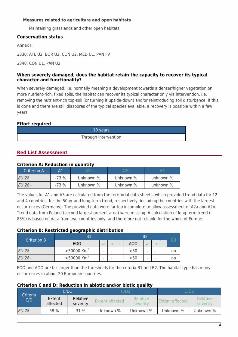
Inland dunes in the National Park Hoge Veluwe, the Netherlands, dominated bystands of the Corynephorion canescentis (Photo: John Janssen).
Details of a Corynephorion canescentis stand in East Poland with tussocks of theGrey Hair-grass (Corynephorus canescens) and the creeping branches of Thymusserpyllum in a carpet dominated by the moss Polytrichum piliferum and the lichenCladonia foliacea (Photo: Jürgen Dengler).
1
Habitat descriptionThese are open grasslands on inland sand-drift areas, dunes and other sites with poorly developed sandy,acidic and nutrient-poor soils, characterized by a pattern of small tussocks of the grass Corynephoruscanescens and/or patches of the stoloniferous graminoids Agrostis vinealis and Carex arenaria in a matrixof lichens, mosses and open sand. The habitat has its main distribution in the North Central Europeanlowland of the Netherlands, Germany and Poland, and in this region the large open landscapes formed bythe habitat are known as ‘Atlantic deserts’. The habitat is considered to be the result of overexploitation ofwoodlands and heathlands since the Middle Ages, and these sand drifts had their largest distribution in themiddle of the 19th century.
The open sand is an extreme habitat, with high temperatures and extreme drought during summer, whereonly a few plants and animals can live. Some of the characteristic fauna here have their main distributionin the Southeast European steppes, for example the grasshopper Oedipoda caerulescens and the butterflyHipparchia semele semele.
Soil development occurs very slowly, due to wind erosion and nutrient poverty. In the Netherlands andGermany the following succession stages have been distinguished: open sand, pioneer communities withPolytrichum piliferum, lichen-rich open grassland with Corynephorus canescens, lichen-rich open grasslandwith Agrostis vinealis and Festuca spp., and more closed grasslands with Carex areanaria andDeschampsia flexuosa with few lichens. Further development leads to heathland with Calluna vulgaris. Thissuccession is exaggerated by nutrient input, for example from nitrogen deposition, which also favours thedominance of the non-native moss Campylopus introflexus. Characteristic lichens of the youngersuccession stages are Stereocaulon condensatum and small-cup lichens, like Cladonia pulivinata, Cladoniacervicornis, Cladonia glauca, Cladonia strepsilis and Cladonia borealis. The Agrostis vinealis stage is alsoindicated by Cladonia portentosa, Cladonia zopfii and Cladonia uncialis. Where wind erosion of sand occursup to a deeper soil layer, moist depressions develop, in which typically Juncus sqarrosus is found.
The habitat occurs in mosaics with heathland, scrub and forest, and such mosaics are anespecially suitable habitat for birds like Lullula arborea and Anthus campestris. Small patches of openCorynephorus vegetation occur as open spots in heathlands, but in such cases these patches should beconsidered as part of dry heathlands, providing some differentiation in structure and some additionalspecies diversity and therefore adding to the quality of the heathland habitat.
Outside the North Central European plains, the habitat is found in lowlands of southern Central Europe, theBaltic states, Southern Sweden and Denmark, Western Ukraine and the region Aquitaine of SouthwestFrance. It occurs rarely in the UK, Italy and the Iberian Peninsula.
Habitat type E1.9b represents the part of the phytosociological order Corynephoretalia canescentis with itsonly alliance Corynephorion canescentis that occurs on sites not located close to the sea coast. On coastaldunes, there are floristically and ecologically very similar to indistinguishable stands, which in the currenttypology are considered as part of the habitat type B1.4a − Atlantic and Baltic coastal stable dunegrasslands (grey dunes).
With decreasing sand mobility, the natural succession of the habitat type typically leads to meso-xericsandy grasslands with closed swards (order Trifolio arvensis-Festucetalia ovinae; habitat type E1.9a −Oceanic to sub-continental inland sand grassland on dry acid and neutral soils). Under subcontinental tocontinental climates on base-rich soils, often sandy grasslands of the order Sedo acris-Festucetalia (habitattype E1.1a Pannonian and Pontic sandy steppe) are inserted in this sequence, while under the mostoceanic climates and most acidic soils, Deschampsia flexuosa grasslands or Calluna vulgaris heaths of theclass Calluno-Ulicetea might follow more or less immediately.
Indicators of good quality
2
Maintenance of open sand, and open grassland in different stages of succession●
Active processes of sand transport by wind●
High diversity in lichens●
Presence and maintenance of populations of characteristic fauna (birds, insects)●
Part of a landscape mosaic with forest and heathland●
No dominance of non-native species, such as Campylopus introflexus●
Thero-Airion Tx. ex Oberd. 1957 (marginal, within a context of Corynephorion)
Koelerion glaucae Volk 1931 (marginal, within a context of Corynephorion)
Annex 1:
2330 Inland dunes with open Corynephorus and Agrostis grasslands
3
23408 Pannonic inland dunes
Emerald:
E1.9 Open non-Mediterranean dry acid and neutral grassland, including inland dune grassland
MAES-2:
Sparsely vegetated land
IUCN:
4.4. Temperate grassland
Does the habitat type present an outstanding example of typical characteristics of oneor more biogeographic regions?Yes
RegionsAtlanticContinental
JustificationThis is a very distinctive habitat type that emerged in the central and northern parts of the Atlantic andContinental biogeographic regions in consequence of centuries of landscape overexploitation and thenbecame a typical element of nutrient poor, sandy landscapes in the North Central European plains,together with Calluna heaths and oligotrophic birch-oak-pine woodlands.
Geographic occurrence and trends
EU 28 Present or PresenceUncertain
Current area ofhabitat
Recent trend inquantity (last 50 yrs)
Recent trend inquality (last 50 yrs)
Austria Present 0.08 Km2 Decreasing DecreasingBelgium Present 8.4 Km2 Decreasing DecreasingCzech Republic Present 2 Km2 Decreasing DecreasingDenmark Present Unknown Km2 Unknown UnknownEstonia Present 0.5 Km2 Decreasing Decreasing
Finland
Aland Islands:Uncertain
Finland mainland:Uncertain
Unknown Km2 Unknown Unknown
France France mainland:Present 30 Km2 Decreasing Decreasing
Germany Present 81 Km2 Decreasing DecreasingHungary Present 1.3 Km2 Decreasing DecreasingIreland Uncertain Unknown Km2 Unknown Unknown
Italy Italy mainland:Present 0.034 Km2 Decreasing Unknown
Latvia Present 4.3 Km2 Decreasing DecreasingLithuania Present 4.7 Km2 Decreasing DecreasingLuxembourg Uncertain Unknown Km2 Unknown UnknownNetherlands Present 43 Km2 Stable DecreasingPoland Present 68 Km2 Unknown Stable
4
EU 28 Present or PresenceUncertain
Current area ofhabitat
Recent trend inquantity (last 50 yrs)
Recent trend inquality (last 50 yrs)
Portugal Portugal mainland:Present 40 Km2 Stable Unknown
Romania Uncertain Unknown Km2 Unknown UnknownSlovakia Present Unknown Km2 Unknown Unknown
Spain Spain mainland:Uncertain Unknown Km2 Unknown Unknown
Sweden Present Unknown Km2 Unknown Unknown
UK United Kingdom:Present Unknown Km2 Unknown Unknown
EU 28 + Present or PresenceUncertain
Current area ofhabitat
Recent trend inquantity (last 50 yrs)
Recent trend inquality (last 50 yrs)
Kaliningrad Present Unknown Km2 Unknown Unknown
Norway Norway Mainland:Uncertain Unknown Km2 Unknown Unknown
Extent of Occurrence, Area of Occupancy and habitat area
Extent ofOccurrence (EOO)
Area ofOccupancy
(AOO)
Currentestimated Total
AreaComment
EU 28 2811350 Km2 1241 380 Km2
Provided country data say 284 km², butseveral countries with occurrences did
not provide data and figures forGermany and Poland appear too low
EU 28+ 2811350 Km2 1241 400 Km2 Kaliningrad and possibly Norway
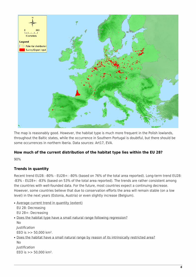
Distribution map
5
The map is reasonably good. However, the habitat type is much more frequent in the Polish lowlands,throughout the Baltic states, while the occurrence in Southern Portugal is doubtful, but there should besome occurrences in northern Iberia. Data sources: Art17, EVA.
How much of the current distribution of the habitat type lies within the EU 28?90%
Trends in quantityRecent trend EU28: -80% - EU28+: -80% (based on 76% of the total area reported). Long-term trend EU28:-83% - EU28+: -83% (based on 53% of the total area reported). The trends are rather consistent amongthe countries with well-founded data. For the future, most countries expect a continuing decrease.However, some countries believe that due to conservation efforts the area will remain stable (on a lowlevel) in the next years (Estonia, Austria) or even slightly increase (Belgium).
Average current trend in quantity (extent)●
EU 28: DecreasingEU 28+: DecreasingDoes the habitat type have a small natural range following regression?●
NoJustificationEEO is >> 50,000 km².Does the habitat have a small natural range by reason of its intrinsically restricted area?●
NoJustificationEEO is >> 50,000 km².
6
Trends in qualityWithin EU28, 58% of the remaining area are degraded with 31% severity, while within EU28+ 58% of theremaining area are degraded with 31% severity.
Average current trend in quality●
EU 28: DecreasingEU 28+: Decreasing
Pressures and threats
This habitat type largely emerged due to human overexploitation of sandy landscapes during pastcenturies and is characterised by very nutrient-poor, acidic soils. Since the land use systems that createdthis type (e.g. by deforestation followed by intensive overgrazing or even arable cultivation) are no longerin place, the main threatening factor is natural succession towards more closed grassland habitats onbetter developed soils, followed by heathlands, shrublands and finally forests. Eutrophication by atmogenicnitrogen input is a second major threat as it speeds up the natural succession and also might facilitateinvasion of competitive non-native (like the moss Campylopus introflexus) and native (like the tall grassCalamagrostis epigejos) species. Sometimes the areas no longer agriculturally used are also afforested.Individual countries also mentioned urbanisation and mining as threats. Sometimes outdoor sports (e.g.motocross) are considered as threats; however, in reality, they might often rather help to keep the sandsmobile and thus the habitat alive. Likewise with military activity, which occurs in some areas.
List of pressures and threatsSylviculture, forestry
Forest planting on open ground
PollutionNitrogen-input
Invasive, other problematic species and genesInvasive non-native speciesProblematic native species
Natural biotic and abiotic processes (without catastrophes)Biocenotic evolution, succession
Conservation and management
The most extensive and best developed stands of this habitat type are currently found on active militarytraining areas where soil disturbance continues through driving of tanks with no agricultural nitrogen input.This seems to be the most effective way to retain the habitat in a good state. In abandoned militarytraining areas and other sites with this habitat type, year-round grazing with robust cattle, sheep and otherherbivores in large-scale pasture landscapes seems to be the most promising approach. Human activitieslike walking on the dunes or motocross (as often) should not be forbidden because they keep the habitatalive, except in places with occurrences of particularly rare species. New stands of this habitat can emergefrom open lignite mining, when extremely nutrient-poor, acidic sand is exposed to the surface. In suchcases therefore part of the former mines should be excluded from usual kinds of recultivation.
List of conservation and management needs
7
Measures related to agriculture and open habitatsMaintaining grasslands and other open habitats
Conservation statusAnnex I:
2330: ATL U2, BOR U2, CON U2, MED U1, PAN FV
2340: CON U1, PAN U2
When severely damaged, does the habitat retain the capacity to recover its typicalcharacter and functionality?When severely damaged, i.e. normally meaning a development towards a denser/higher vegetation onmore nutrient-rich, fixed soils, the habitat can recover its typical character only via intervention, i.e.removing the nutrient-rich top-soil (or turning it upside-down) and/or reintroducing soil disturbance. If thisis done and there are still diaspores of the typical species available, a recovery is possible within a fewyears.
Effort required10 years
Through intervention
Red List Assessment
Criterion A: Reduction in quantityCriterion A A1 A2a A2b A3
The values for A1 and A3 are calculated from the territorial data sheets, which provided trend data for 12and 4 countries, for the 50-yr and long-term trend, respectively, including the countries with the largestoccurrences (Germany). The provided data were far too incomplete to allow assessment of A2a and A2b.Trend data from Poland (second largest present area) were missing. A calculation of long term trend (-83%) is based on data from two countries only, and therefore not reliable for the whole of Europe.
Criterion B: Restricted geographic distribution
Criterion BB1 B2
B3EOO a b c AOO a b c
EU 28 >50000 Km2 - - >50 - - noEU 28+ >50000 Km2 - - >50 - - no
EOO and AOO are far larger than the thresholds for the criteria B1 and B2. The habitat type has manyoccurrences in about 20 European countries.
Criterion C and D: Reduction in abiotic and/or biotic quality
The data for C/D1 were calculated from the territorial data sheets, which provided assessments for 11countries. No data were available for C/D2 and C/D3. The degradation quality refers to both biotic featuresand abiotic circumstances.
Criterion E: Quantitative analysis to evaluate risk of habitat collapseCriterion E Probability of collapse
EU 28 UnknownEU 28+ Unknown
There is no quantitative analysis available that estimates the probability of collapse of this habitat type.
Overall assessment "Balance sheet" for EU 28 and EU 28+ A1 A2a A2b A3 B1 B2 B3 C/D1 C/D2 C/D3 C1 C2 C3 D1 D2 D3 E
EU28 EN DD DD DD LC LC LC NT DD DD DD DD DD DD DD DD DDEU28+ EN DD DD DD LC LC LC NT DD DD DD DD DD DD DD DD DD
Overall Category & CriteriaEU 28 EU 28+
Red List Category Red List Criteria Red List Category Red List CriteriaEndangered A1 Endangered A1
Confidence in the assessmentMedium (evenly split between quantitative data/literature and uncertain data sources and assured expertknowledge)
AssessorsJ. Dengler
ContributorsType description: J.A.M. Janssen (revised by J. Dengler)
Territorial data: S. Armiraglio, S. Assini, G. Buffa, J. Capelo, M. Chytrý, J.M. Courvreur, D. Espírito-Santo, P.
9
Finck, Z. Kącki, G. Király, A. Mikolajczak, D. Paelinckx, D. Paternoster, V. Rašomavičius, U. Raths, U.Riecken, E. Roosaluste, S. Rusina, A. Ssymank, E. Weeda.
Working Group Grasslands: I. Biurrun, J. Dengler, D. Gigante, Z. Molnar, D. Paternoster, J. Rodwell, J.Schaminée, R. Tzonev
ReviewersJ. Rodwell
Date of assessment21/02/2016
Date of review25/03/2016
References
Hentschel, M. 2011. Die Gliederung des Corynephorion Klika 1931 (Silbergrasfluren) in Europa. PhD. thesis,University of Münster, Münster, DE.
Jentsch, A. and Beyschlag, W. 2003. Vegetation ecology of dry acidic grasslands in the lowland area ofcentral europe. Flora 198: 3–25.
Jeckel, G. (1984): Syntaxonomische Gliederung, Verbreitung und Lebensbedingungen nordwestdeutscherSandtrockenrasen (Sedo-Scleranthetea). Phytocoenologia 12: 9–153.
Juśkiewicz-Swaczyna, B. 2009. The psammophilous grassland community Corniculario aculeatae-Corynephoretum canescentis in the Masurian Lake District (NE Poland). Tuexenia 29: 391–408.
Sparrius, L.B. 2011. Inland dunes in the Netherlands: soil, vegetation, nitrogen deposition and invasivespecies. PhD thesis University of Amsterdam, Amsterdam, NL.


![Full page fax print - Terra Nova Nurseries, Inc....Hardy to Zone 9. [34] Corynephorus canescens 'Spiky Blue' Like a big blue-greer) Koosh ball, silver rass forms a 10-inch-tall dome](https://static.documents.pub/doc/80x56/60a1334700aca75fb7364500/full-page-fax-print-terra-nova-nurseries-inc-hardy-to-zone-9-34-corynephorus.jpg)


