Journal of Historical Geography, 4,4 (1978) 333-341 Early Cotswold woodland Della Hooke Many “wold” names are derived from the OE wald, meaning “woodland”. In a recent paper Everitt examined the evidence for Kent and suggested that areas of wold down- land had been wooded in the Anglo-Saxon period. They had also been territorially linked to river-estates as areas of outlying wood-pasture. The present paper examines the evidence for the Cotswolds. Here the name “weld” is applied to an area which was largely open pasture by the medieval period and the use of the term in its later sense of “high, open country” would not have been out of place. Yet the evidence from early place-names and pre-Conquest charters suggests that a great deal of woodland was present in the Anglo-Saxon period, especially in the valleys dissecting the escarpment and along the scarp face. Although this was a watershed area, divided between adjacent valley-based estates, as in Kent, there is little direct evidence here of an early interest in woodland-pasture. The importance of the area seems to have arisen in the middle and later Anglo-Saxon period as a result of an increased use of the upland for sheep pasture. Nevertheless, the term “weld” seems to date from an earlier period when woodland was indeed extensive. Alan Everitt has recently indicated that both the Weald and Wold areas of Kent were originally wooded. His argument was based upon ‘the evidence of place- names, of early charters, of topography and of tenurial and ecclesiastical relation- ships”, and he extended his hypothesis to include the Wolds of West Cambridge- shire and the area bordering Huntingdonshire, Bedfordshire and Northampton- shire known as the Bromswold .[ll Since the Cotswolds of Gloucestershire also derive their name from the Germanic wald an examination of the place-names and charter evidence available for this area provides some test of Everitt’s conclusions. Both Weald and Wold are derived from OE wald meaning “woodland, a tract of woodland, high forest-land”, and Margaret Gelling points to the dialectic difference between the two, with wold an Anglian form and weald a Saxon form.t21 However, although Weald remained a name associated with a thickly wooded landscape Wold was to become associated by medieval times with “elevated . . . open country or moorland”, a change of meaning associated by Smith with “the clearing of the large forest-tracts ” ~1 References to Wold in medieval literature . such as “Hereby apon a wolde Scheppardis watchyng there fold”t41 show that 111 A. Everitt, River and weld, reflections on the historical origin of regions and pays Journal of Historical Geography 3 (1977) 1-19 121 M. Gelling, The place-names of Oxfordshire I English Place-Name Society (hereafter E.P.N.S.) XXIII (1953) xix [3] A. H. Smith, English place-name elements II E.P.N.S. XXVI (1970) 239-40, and see Everitt’s comments op. cit. 10-15 141 Coventry Corpus Christi plays (1500), cited by A New English dictionary on historical prin- ciples X, Pt. II (Oxford 1928) 242 0305-7488/78/040333 + 09 $02.00/O @ 1978 Academic Press Inc. (London) Ltd
Transcript
Journal of Historical Geography, 4,4 (1978) 333-341
Early Cotswold woodland
Della Hooke
Many “wold” names are derived from the OE wald, meaning “woodland”. In a recent paper Everitt examined the evidence for Kent and suggested that areas of wold down- land had been wooded in the Anglo-Saxon period. They had also been territorially linked to river-estates as areas of outlying wood-pasture. The present paper examines the evidence for the Cotswolds. Here the name “weld” is applied to an area which was largely open pasture by the medieval period and the use of the term in its later sense of “high, open country” would not have been out of place. Yet the evidence from early place-names and pre-Conquest charters suggests that a great deal of woodland was present in the Anglo-Saxon period, especially in the valleys dissecting the escarpment and along the scarp face. Although this was a watershed area, divided between adjacent valley-based estates, as in Kent, there is little direct evidence here of an early interest in woodland-pasture. The importance of the area seems to have arisen in the middle and later Anglo-Saxon period as a result of an increased use of the upland for sheep pasture. Nevertheless, the term “weld” seems to date from an earlier period when woodland was indeed extensive.
Alan Everitt has recently indicated that both the Weald and Wold areas of Kent were originally wooded. His argument was based upon ‘the evidence of place- names, of early charters, of topography and of tenurial and ecclesiastical relation- ships”, and he extended his hypothesis to include the Wolds of West Cambridge- shire and the area bordering Huntingdonshire, Bedfordshire and Northampton- shire known as the Bromswold .[ll Since the Cotswolds of Gloucestershire also derive their name from the Germanic wald an examination of the place-names and charter evidence available for this area provides some test of Everitt’s conclusions.
Both Weald and Wold are derived from OE wald meaning “woodland, a tract of woodland, high forest-land”, and Margaret Gelling points to the dialectic difference between the two, with wold an Anglian form and weald a Saxon form.t21 However, although Weald remained a name associated with a thickly wooded landscape Wold was to become associated by medieval times with “elevated . . . open country or moorland”, a change of meaning associated by Smith with “the clearing of the large forest-tracts ” ~1 References to Wold in medieval literature . such as “Hereby apon a wolde Scheppardis watchyng there fold”t41 show that
111 A. Everitt, River and weld, reflections on the historical origin of regions and pays Journal of Historical Geography 3 (1977) 1-19
121 M. Gelling, The place-names of Oxfordshire I English Place-Name Society (hereafter E.P.N.S.) XXIII (1953) xix
[3] A. H. Smith, English place-name elements II E.P.N.S. XXVI (1970) 239-40, and see Everitt’s comments op. cit. 10-15
141 Coventry Corpus Christi plays (1500), cited by A New English dictionary on historical prin- ciples X, Pt. II (Oxford 1928) 242
Wold was by then being associated with sheep country, normally open land, and Harrison, writing in the sixteenth century, confirms the meaning then currently in existence : “This may suffice for the use of the word We&, which now differeth much from Wold. For as that signifieth a woody soil, so this betokeneth a soil without wood or plaine champaign country, without any store of trees.“[‘l
In the West Midlands all the place-names containing wald are late recordings and may reflect the later usage of the term. The name “Cotswold” itself is not recorded until the twelfth century, when Giraldus Cambrensis speaks of the montana de Codueuualt when describing land between Blockley and Evesham, the northern part of today’s Cotswold Hills. L21 By that time much of the Cotswolds was indeed “high, open country” and the name could be regarded as having no relevance to the debate, being simply a later usage when meanings had changed. However the name does appear to have had an earlier origin, for, as “the wald of Cod”, it con- tains an Anglo-Saxon personal name and this name is found elsewhere in the region in at Codesuuellan and Codestun, the “spring” and “estate’ of C5d” respectively, both identified with Cutsdean in the North Cotswolds, and in Codes &rig, “the burh or fortification of CGd”, on the northern boundary of Upper Swell parish.131 These names were recorded in A.D. 780, A.D. 977 and A.D. 1055 respectively and suggest that the association of C5d and wold originated at a similarly early date.
In the eighth and ninth centuries wald seems to have been used in its original sense in the West Midlands, for although absent from early place-names it is used in a number of pre-Conquest charters of areas that were heavily wooded. In Gloucestershire a Waldes Wellan, or “woodland spring”, is recorded in a charter of Stoke Bishop,[41 an area that lay within the later Forest of Kingswood. In corrupt form the term also occurs as Oldan on the boundary of Hasfield which formed part of the estate of Deerhurstt51 and lay within wooded country in the north of the county, and as a be Oldanlof &zre Oldan on the boundary of Croome d’Abitot in Worcestershire,t61 an estate which again lay within the later Forest of Horewell. Although Smith translates Cotswold as “Cod’s high open land”L71 there appears to be little direct evidence of wald used in such a context in the Anglo- Saxon period and since the name Cotswold may have originated at that time the nature of the landscape about Cutsdean in the Anglo-Saxon period obviously deserves careful attention.
An eighth-century charter refers to the high land in Cutsdean as the monte quam nominant incola mons Huuicciorum, “the hill which the inhabitants call ‘the hill of the Hwicce’ “.nJ1 The Hwiccan kingdom extended over the present counties
[l] W. Harrison, p. 261 of G. Edelen (Ed.), The description of England (New York 1968) [2] Giraldus Cambrensis, Speculam ecclesiae, in J. S. Brewer (Ed.) Rolls Series IV, 1873, 106 [3] H. P. R. Finberg, The early charters of the West Midlands (Leicester 1961) 72-6; S 1026,
K 801 (U. Swell); S 116, B 236, K 140 (Cutsdean); S 1335, B 1299 (Cutsdean). See charters in P. H. Sawyer, Anglo-Saxon charters, an annotated list and bibliography (London 1968); W. de Gray Birch, Cartularium saxonicum (London 1885-99); J. M. Kemble, Codex diplo- maticus aevi saxonici (London 1839-48)
[4] S 218, B 551, K 313 (Stoke Bishop) [5] S 1551, H. P. R. Finberg, op. cit. 82 (Deerhurst); for a reinterpretation of the boundary
clause see A. H. Smith, The place-names of Gloucestershire III E.P.N.S. XL (1964) 153 [6] S 1322, B 1235, K 549 (Croome D’Abitot), boundaries reinterpreted by R. For&erg, A
contribution to a dictionary of Old English place-names (Nomina Germanica, 9, Uppsala 1950) 212
[7] A. H. Smith, The place-names of Gloucestershire I E.P.N.S. XXXVIII (1964) 2 [8] S 116, op. cit.
EARLY COTSWOLD WOODLAND 335
of Worcestershire, most of Gloucestershire and part of Warwickshire and was cen- tred upon Worcester in the Severn valley. Cutsdean, the Mona . . . Huuicciorum, was granted with estates at Teddington, Little Washbourne and Bredon’s Norton to St Peter’s Minster, Bredon and this may reflect a linkage between this area and the latter estate, established in the Avon valley near its confluence with the Severn. Such an association between watershed areas and riverine-based estates was noted by Everitt in Kent and found to be typical of wooded areas used initially in a system of seasonal transhumance, Similar arrangements have been noted in Warwickshire by Ford[ll and again found to be typical of associations between developed and woodland areas. While both of these areas were ones in which Anglo-Saxon territorial arrangements were to predominate, the link between lowland centres and outlying areas used for seasonal transhumance is also clearly established in British areas and may have very ancient origins. In present-day Oxfordshire an area of dense woodland lying beyond the confines of the Hwiccan kingdom as revealed by later diocesan boundaries bore the name of Wychwood, “the wood of the Hwicce”. The name may merely indicate woodland on the frontiers of the Hwiccan kingdom since links from the Severn-Avon valleys to the Cotswolds are much more firmly established.
This watershed area of high land was to become subdivided between adjacent valley-based estates. The Abbeys of Winchcombe and Tewkesbury also acquired large estates on part of the Cotswold escarpment and the Abbey of Evesham and the Church of Worcester gained lands further east. In Kent, Everitt found such areas characterized by individual scattered settlements which developed from sea- sonal shielings, and although nucleated settlements were to become established in the valleys of the North Cotswolds isolated farms remain typical of the upland countryside. The territorial arrangements do seem, therefore, to show some simi- larity with those noted by Everitt in Kent. There is, however, no direct evidence of an interest in the North Cotswolds as a source of woodland-pasture and its economic importance appears to stem from later developments.
Place-name evidence The words of Giraldus Cambrensis suggest that it was the north Gloucestershire
part of the Oolitic escarpment that was called Cotswold in the twelfth century. This is the area in which associations with Cod are found, but the mans Huuicciorum of Cutsdean is extended in a later tenth-century charter as monte Wiccisca to cover the estates of Northwick and Dorn in Blockley, Evenlode, Daylesford and Icomb, taking in not only the Oolitic limestone escarpment but the adjacent valley of the River Evenlode, underlain by Lower Lias clays. Later references describe Cotswold as “towards Clapley” in Sezincote and add the suffix wold to the names of Withing- ton, Stow-on-the-Wold and Westington. [3J There are few references to wold in south-east Gloucestershire; the term seems to have been particularly associated with the escarpment and its surrounding valleys in the north-east of the present county. It is perhaps, therefore, in this area that one should seek for the early wald of C5d.
Place-name evidence shows that woodland was extensive along the scarp face of the Cotswolds in the Anglo-Saxon period at least as far north as Winchcombe
111 W. J. Ford, Some settlement patterns in the central region of the Warwickshire Avon, pp. 278-9 of P. H. Sawyer (Ed.), Medieval settlement, continuity and change (London 1976)
[2] S 731, B 1135, K 514 [3] A. H. Smith, op. cit. I, 2
336 D. HOOKE
(Fig. l).[ll A number of settlement names include the term Z&~/Z, among them Stan- ley Pontlarge and Sudeley, “the stony IZah” and “the south IZah”, names which probably indicate cleared areas within woodland, and later recorded l&zh names are also abundant. The survival of this scarp-face woodland is also reflected in the Domesday assessment in the north of the county. Even on parts of the scarp-face to the south of Minchinhampton where little woodland is recorded in 1086t21 place-name elements confirm that woodland was present at an earlier period. Moreover, woodland appears to have extended over the higher parts of the escarp- ment itself on to the Inferior Oolite, represented by such /Zah names as Wistley Hill in Coberley. Apart from 1Zah few other terms associated with woodland gave their name to major settlements. Notgrove, “the wet grove”, in the valley of the Sherbourne Brook, remains the only wood name recorded in a pre-Conquest context. Late-recorded names may not, of course, be used safely to reconstruct the distribution of early woodland, but they have been included on the map and seem to give some indication of woodland survival.
Charter evidence
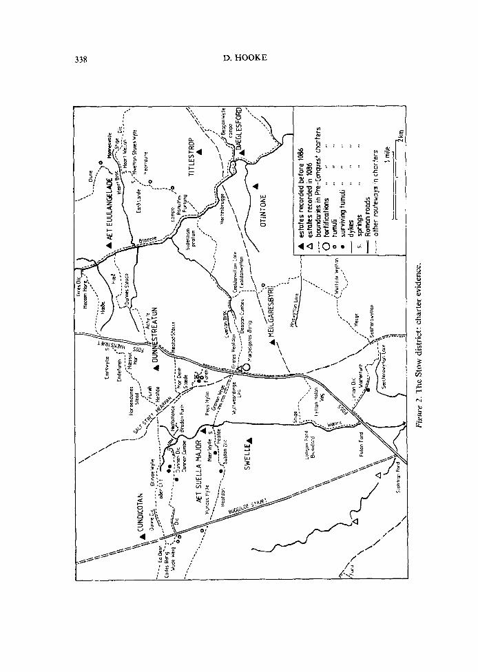
It is to Anglo-Saxon charters that one must turn for a more intimate knowledge of the landscape in the pre-Conquest period for these frequently carry within them a wealth of local detail, especially in boundary clauses referring to local landmarks. Although some areas are better endowed with charters than others and the North Cotswolds is not particularly rich in this respect, valuable additional information may be derived from this source. t31 Three landscape regions may be noted. In the valley of the Evenlode and its surrounding foot-hills there are more references to agriculture in the Middle and Later Anglo Saxon period than have been noted anywhere else in the county (Fig. 2), Although some terms like heafod, literally “a head”, must be omitted because they are often used in a purely topographical sense, others such as jreo Xceras Ear8 Landes, “three acres of ploughland”, Rahulfes Furlung que est in camp0 de Eunelode, “Rahulf’s furlong which is in the open field of Evenlode”, both referring to the parish of Evenlode, and &zt Hebfodland, “the headland”, of Broadwell,r41 seem quite specifically to describe areas of arable. Much of this detail is shown on Fig. 2. This area had already been intensively cleared and cultivated in Roman times and no fewer than eight Romano- British settlements are known within a few miles of the junction of the Fosse Way and the Ryknield Street. 151 Evidence of numerous other enclosures and probable settlements spread out over the Cotswold dip slope is revealed by cropmarks and pottery scatter, so that considerable clearance of woodland had been effected already in Roman times. On the drift-covered slopes bordering the Evenlode open heathland is evident with charter references to such land extending across the
(11 A. H. Smith, op. ciz. IV E.P.N.S. XL1 (1965) Map 3 [2] See C. S. Taylor, An analysis of the Domesday survey of Gloucestershire (Bristol 1899) and
H. C. Darby, Gloucestershire, pp. 26-32 of H. C. Darby and I. B. Terrett (Eds) The Domesday geography of Midland England (Cambridge 1954)
[3] Study at present being undertaken by the author for a Ph.D. thesis, Department of Geography, University of Birmingham
[4] S 1325, B 1238, K 554, K 1362 (Evenlode); S 1548, K 1367 (Aldestrop); S 1550, K 1359 (Broadwell)
[5] Royal Commission on Historical Monuments, England (R.C.H.M.E.), Ancient and historical monuments in the county of Gloucester I: Iron Age and Roman0 British monuments in the Gloucestershire Cotswolds (London H.M.S.O. 1976)
EARLY COTSWOLD WOODLAND 337
SWEL
LEA
1
A
esta
tes
reco
rded
be
fore
10
86
: A
es
tate
s re
cord
ed
in 1
086
/ ---
- bo
unda
ries
in P
re-C
onqu
est
char
ters
:’ 0
fort
ifica
tions
.q
9’
‘a
0 0
-
5. L
- --
tum
uli
,, I,
I<
surv
ivin
g tu
mul
i ‘9
*’
‘0
dyke
s ,#
II
,I
sprin
gs
,, 8.
,a
Rom
an
rood
s ot
her
rout
ewoy
s *n
cha
rter
s
1 m
ile
2km
Fiau
re
2.
The
St
ow
dist
rict
: ch
arte
r ev
iden
ce.
EARLY COTSWOLD WOODLAND 339
eastern portion of Donnington parish. tll From the evidence of woodland names, clearance seems to have spread outwards from the line of the Fosse Way with woodland pushed back north-westwards towards the Cotswold scarp and south- eastwards towards Wychwood Forest on the lower dip slope in Oxfordshire.
Yet within this cleared area there was sufficient woodland surviving to provide cover for the stags which gave their name to a spring, a stream, a hill, a valley and even a bridge, upon the bounds of the estate of Evenlode.[21 Stags are also asso- ciated with the Heortford of Notgrove and Aston in the valley of the Windrush,‘3J a place also frequented by the wild cat, as revealed by the place-name Castlett Farm in the parish of Guiting Power. Charter names confirm that woodland sur- vived in the valleys which drained the dip slope of the escarpment for the bounds of Maugersbury ran from i3es Gr6fe.s Hedfdon, “the head of the grove”,[41 and refer- ence to Wulfweardinge Lea, “the 1Eah of Wulfweard’s folk”, on the boundary of Upper Swell,c51 indicates woodland in the valley of the Dikler. Today, mixed woodland is still characteristic of the steeply sloping sides of the incised dip-slope valleys, but agricultural land is at a premium and the woodland is rarely extensive. On higher land it is confined to limited areas of game covert.
Woodland animals are also much in evidence in the Anglo-Saxon woods of the scarp slope, especially in the area south of Winchcombe where the limestone is deeply dissected by the headwaters of the River Isbourne, Not only are roe deer and harts mentioned in charters but wolves gave their name to the WuZJIeage on
the northern boundary of Southam and Brockhampton, then within the estate of Timbingctun.[61 A charter of Hawling[‘I confirms that woodland covered the higher slopes of the escarpment and the name Roel, derived from an eleventh-century stream name RawelZ,C81 indicates the presence of roebuck. Although Roman villas were established near the headwaters of the Beesmoor Brook in Sudeley the easternmost site, in Sudeley Wood, and perhaps, too, the westernmost at Wad- field,IQ1 lay within the bounds of Hawling woodland and it is possible that some regeneration of woodland had occurred in the sub-Roman period. Woodland names are most frequent in this area and woodland still clothes large areas of the scarp face today. The higher woods have retreated but Guiting Wood is still an extensive area of mixed woodland near the northern boundary of Roel.
Woodland was undoubtedly present upon the higher parts of the dip slope in the southern part of the region under discussion, and in the valleys over a much wider area. What is particularly difficult to judge is the extent of the woodland over the northern part of the dip slope. LZah place-names are not entirely absent, for Block- ley, situated on the headwaters of the Knee Brook, is “the ZZah of Blocca” and late-recorded names include Luckley Farm in Longborough, “the Z2ah of Lucca”, and Clapley Down in Sezincote, “the hill clearing”, here given to a spur of upland between the deeply incised valley of the Dikler and one of its tributaries. On the
[l] S 115, B 229, K 136, iii pp. 384-5 (Donnington) [2] S 1325; S 1238, K 963 (Daylesford); S 1548; S 550, B 882, K 426, iii p. 429, K 1360 (Dayles-
ford) [3] S 99, B 165, K 90 (Notgrove and Aston) [4] S 1553, K 1365 (Maugersbury) [S] H. P. R. Finberg, op. cit. 72-6 [6] S 141, B 246, K 150, iii pp. 385-6 (Timbingctun) [7j H. P. R. Finberg, op. cit. 191-3 [8] A. H. Smith, op. cit. II E.P.N.S. XXXIX (1964) 21 [9] R.C.H.M.E. op. cit. 112-14
340 D. HOOKE
western boundaries of Upper Swell and Donnington were trackways linking wood- land with cleared land referred to respectively as Fildene Wege and Wude Weig.[ll A landmark referred to as Ea Denn at the westernmost point of the estate of Don- nington may be a rare reference in this area to the term denn, meaning “woodland pasture”.t21 There are, however, indications of clear open land upon the higher parts of the limestone escarpment in the north of the area. A Lafercan Beorh, probably “the barrow where larks are plentiful”, stood upon the summit of Cuts- dean Hill (occasionally beorg may refer to the hill itself but in this area often describes tumuli) and the lark is a bird which favours an open habitat, preferring grassy country with a few shrubs and scattered trees. Similarly plants associated with such a habitat are in evidence, with thistles apparently occurring in quantity near the Jistel Mere or “thistle pond” of Broadway and woad growing near the boundaries of Broadway and Cutsdean. [31 A reference to Jane Ealdan Fe/d, “the old open country”, on the high land near Broadway suggests that here higher land had been cleared at an early date, although feld does seem to indicate open land on the margins of wooded areas. Although silva is recorded at Hazelton and Hawling in the south and along the scarp slope as far north as Stanton, the Domesday record confirms that little woodland remained in the North Cotswolds by the time of the Conquest. Apart from woodland measuring half a league by half a league in the manor of Blockley, t41 the sole reference to woodland on the northern dip slope is de silva et pastura xl gallenas, “woodland and pasture rendering 40 hens” in the manor of Temple Guiting. Charter and place-name evidence suggests that much of the woodland had gone by the Middle and Later Anglo-Saxon period. Certainly it seems to have been cleared sufficiently quickly for it to have little influence upon the place-names of the area and there is no jndication of the use of the term weald as understood in the later Middle Ages.
The reason for clearance is not far to seek. While the light soils of the Oohtic limestone would respond readily to initial cultivation, perhaps in association with Roman or even earlier settlement, the presence of grazing animals in large num- bers would significantly inhibit the regeneration of woodland. Details of the economy practised in the Roman period are as yet not forthcoming but there can be little doubt that sheep-rearing was being actively carried out on the escarpment by the mid-Anglo-Saxon period. By the eighth century the Abbess of St Peter’s, Gloucester, had acquired land at Pinswell in Colesbourne for bringing in her flocksr51 and in A.D. 784 Esme made a payment which included 100 sheep for a grant of land at Evenlode. L61 The existence of a settlement known as Shipton, with subsidiary settlements Shipton Oliffe and Shipton Solers, lying in a tributary valley of the Coin, implies that that part of the Cotswolds at least was sheep country.[71 There is little direct evidence for the North Cotswolds but on the upper
[l] H. P. R. Finberg, op. cit. 72-4; S 115, B 229, K 136, iii pp. 384-5 (Donnington) [2] A. H. Smith, English place-name elements I E.P.N.S. XXV (1970) 129; but &m j20f Denne
in a charter of Bickmarsh, Warks, S 751, B 1201, K 536, may be “thieve’s den” and M. Gelling notes one occurrence in Oxfordshire on the boundary of Taynton, see M. Gelling, op. cit. 488
[3] S 786, B 1282, K 570 (Broadway); S 1335; S 1353, K 660 (Cutsdean) [4] J. H. Round, The text of the Worcestershire Domesday The Victoria County History of the
Counties of England, Worcestershire I (1901) 293a [5] H. P. R. Finberg, Some early Gloucestershire estates, pp. 12-14 of H. P. R. Finberg (Ed.)
Gloucestershire studies (Leicester 1957) [6] S 122, B 244, K 147 [7] A. H. Smith, op. cit. IV E.P.N.S. 6
EARLY COTSWOLD WOODLAND 341
valley slopes in Cutsdean itself, tenth-century charters record a Scepe Clif, or “sheep cliff”, and the woad plant recorded here and elsewhere may well have been grown for its wool-dyeing properties. AgriculturaI communities, usually valley-based, were also thriving by the Conquest.
Conclusions
The evidence would suggest that woodland disappeared most rapidly from the northern areas of the Oolitic limestone escarpment. It remained dense along the scarp slope and probably in the valleys which dissect both the scarp and dip slopes. Originally, however, it appears to have spread over the higher slopes, especially over the watershed area between the headwaters of the Isbourne and the Windrush. A great deal of the watershed area seems to have been heavily wooded and, as a frontier area between valley estates to the north-west, west, north-east and east, perhaps represented an area of intercommoning. In this way it may originally have shared many of the characteristics noted by Everitt on the higher lands of Kent. As in Kent, it remained linked to the riverine estates in a reflection of early territorial arrangements and upland development appears to have been of a secondary nature. In the North Cotswolds, however, woodland clearance seems to have been effected early and woodland has therefore left less impression upon the place-names of the region than anywhere examined by Everitt in Kent. Clear- ance was probabIy the result of an increasing use of the land for sheep pasture, especially on lands held by the Church of Worcester and by the Abbey of Evesham. The Abbot of Evesham, indeed, was sufficiently aware of the commercial possi- bilities to establish the market town of Stow-on-the-Wold in the mid-eleventh cen- tury.lll
The reference to the personal name Cod suggests that the name Cotswold de- veloped in the Anglo-Saxon period, perhaps in the early stages of the Anglo-Saxon takeover, and that at this date it did indeed indicate an area of woodland. The distribution of similar place-names suggests that the woodland of Cod should be sought upon the higher part of the escarpment above the headwaters of the Wind- rush. Little is, as yet, understood about the names associated with particular individuals but the fortification of Cod apparently lay to the east (Fig. I), while the settlement associated with him was in the Windrush valley and the woodland perhaps away to the west. The evidence from Gloucestershire is not conclusive but does seem to support Everitt’s hypothesis that many Wold areas were initially areas of woodland, linked territorially as outlying summer pastures with river- estates. Cotswold is perhaps one of these names which was applied to an area at a very early date, giving a fleeting insight into the nature of the landscape as it was observed by the earliest Anglo-Saxon settlers in a district.r21
Department of Geography, University of Birmingham, Birmingham
[l] C. R. Elrington and K. Morgan, Stow-on-the-Wold The Victoria County Histary offhe Coun- ties of England, Gloucestershire VI (1965) 144
[2] The author wishes to thank Dr M. Gelling and Mr T. R. Slater for their help and encourage- ment during the course of this work.