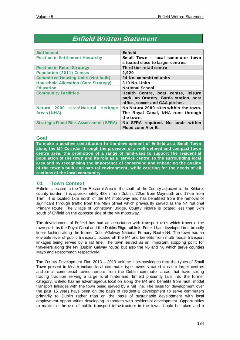
Volume 5 Enfield Written Statement Enfield Written Statement Settlement Enfield Position in Settlement Hierarchy Small Town – local commuter town situated close to larger centres. Position in Retail Strategy Third tier retail centre Population (2011) Census 2,929 Committed Housing Units (Not built) 24 No. committed units Household Allocation (Core Strategy) 319 No. Units Education National School Community Facilities Health Centre, boat centre, leisure park, an Oratory, Garda station, post office, soccer and GAA pitches. Natura 2000 sites/Natural Heritage Areas (NHA) No Natura 2000 sites within the town. The Royal Canal, NHA runs through the town. Strategic Flood Risk Assessment (SFRA) No SFRA required. No lands within Flood zone A or B. Goal To make a positive contribution to the development of Enfield as a Small Town along the M4 Corridor through the provision of a well-defined and compact town centre area, the promotion of a range of land-uses to support the residential population of the town and its role as a ‘service centre’ to the surrounding local area and by recognising the importance of conserving and enhancing the quality of the town’s built and natural environment, while catering for the needs of all sections of the local community. 01 Town Context Enfield is located in the Trim Electoral Area in the south of the County adjacent to the Kildare, county border. It is approximately 42km from Dublin, 22km from Maynooth and 17km from Trim. It is located 1km north of the M4 motorway and has benefited from the removal of significant through traffic from the Main Street which previously served as the N4 National Primary Route. The village of Johnstown Bridge, County Kildare is located less than 3km south of Enfield on the opposite side of the M4 motorway. The development of Enfield has had an association with transport uses which traverse the town such as the Royal Canal and the Dublin/Sligo rail link. Enfield has developed in a broadly linear fashion along the former Dublin/Galway National Primary Route N4. The town has an enviable level of public transport, located off the M4 and benefits from multi modal transport linkages being served by a rail line. The town served as an important stopping point for travellers along the N4 (Dublin Galway route) but also the N5 and N6 which serve counties Mayo and Roscommon respectively. The County Development Plan 2013 – 2019 Volume I acknowledges that the types of Small Town present in Meath include local commuter type towns situated close to larger centres and small commercial towns remote from the Dublin commuter areas that have strong trading tradition serving a large rural hinterland. Enfield presently falls into the former category. Enfield has an advantageous location along the M4 and benefits from multi modal transport linkages with the town being served by a rail line. The basis for development over the past 15 years have been on the basis of residential development to serve commuters primarily to Dublin rather than on the basis of sustainable development with local employment opportunities developing in tandem with residential development. Opportunities to maximise the use of public transport infrastructure in the town should be taken and a 134
Transcript
Volume 5 Enfield Written Statement
Enfield Written Statement Settlement Enfield Position in Settlement Hierarchy Small Town – local commuter town
situated close to larger centres. Position in Retail Strategy Third tier retail centre Population (2011) Census 2,929 Committed Housing Units (Not built) 24 No. committed units Household Allocation (Core Strategy) 319 No. Units Education National School Community Facilities Health Centre, boat centre, leisure
park, an Oratory, Garda station, post office, soccer and GAA pitches.
Natura 2000 sites/Natural Heritage Areas (NHA)
No Natura 2000 sites within the town. The Royal Canal, NHA runs through the town.
Strategic Flood Risk Assessment (SFRA) No SFRA required. No lands within Flood zone A or B.
Goal To make a positive contribution to the development of Enfield as a Small Town along the M4 Corridor through the provision of a well-defined and compact town centre area, the promotion of a range of land-uses to support the residential population of the town and its role as a ‘service centre’ to the surrounding local area and by recognising the importance of conserving and enhancing the quality of the town’s built and natural environment, while catering for the needs of all sections of the local community. 01 Town Context Enfield is located in the Trim Electoral Area in the south of the County adjacent to the Kildare, county border. It is approximately 42km from Dublin, 22km from Maynooth and 17km from Trim. It is located 1km north of the M4 motorway and has benefited from the removal of significant through traffic from the Main Street which previously served as the N4 National Primary Route. The village of Johnstown Bridge, County Kildare is located less than 3km south of Enfield on the opposite side of the M4 motorway. The development of Enfield has had an association with transport uses which traverse the town such as the Royal Canal and the Dublin/Sligo rail link. Enfield has developed in a broadly linear fashion along the former Dublin/Galway National Primary Route N4. The town has an enviable level of public transport, located off the M4 and benefits from multi modal transport linkages being served by a rail line. The town served as an important stopping point for travellers along the N4 (Dublin Galway route) but also the N5 and N6 which serve counties Mayo and Roscommon respectively. The County Development Plan 2013 – 2019 Volume I acknowledges that the types of Small Town present in Meath include local commuter type towns situated close to larger centres and small commercial towns remote from the Dublin commuter areas that have strong trading tradition serving a large rural hinterland. Enfield presently falls into the former category. Enfield has an advantageous location along the M4 and benefits from multi modal transport linkages with the town being served by a rail line. The basis for development over the past 15 years have been on the basis of residential development to serve commuters primarily to Dublin rather than on the basis of sustainable development with local employment opportunities developing in tandem with residential development. Opportunities to maximise the use of public transport infrastructure in the town should be taken and a
134
Volume 5 Enfield Written Statement
greater integration of land use and transport should be promoted. However, this must be managed to ensure that the town develops in a balanced manner, providing employment locally rather than creating a dependence on outward commuting for employment, even by public transport. It will be important to monitor future development patterns in the town to ensure that this does not happen. It is the objective of the Planning Authority to secure the consolidation and development of Enfield as a sustainable service centre in the south west of the County along the M4 Corridor. It is essential that development takes place in a manner that is capable of being supported by adequate water services and community services and in a way which consolidates the town’s character and develops the considerable amenity potential associated with the Royal Canal. Enfield has a commuter rail service to Dublin, good bus connections to Dublin and the west of the country, ready access to the M4 Motorway, proximity to Maynooth and the Greater Dublin Area and the availability of industrial lands. Taking all of these matters into account, it is considered the development of a balanced and sustainable community is possible and desirable. This land use framework seeks to provide the basis to achieve this strategy. The land use strategy provides that new land-use zonings are closely linked to, and integrated with, the existing town, thereby encouraging more sustainable modes of transportation such as walking and cycling. Furthermore, it promotes the future development of the town in a co-ordinated, planned and sustainable manner in order to conserve and enhance the established natural and historical amenities of the town and its intrinsic character. The provision of a compact, vibrant and effective town centre is essential if Enfield is to cater for its current and future population needs in a sustainable manner. In addition, the Framework seeks to provide the conditions conducive to the creation of employment opportunities locally. 02 Water and Wastewater Services The town is currently served by Enfield waste water treatment plant located approximately 1.5km southwest of the town to the north of Johnstown Bridge, County Kildare. The waste water treatment plant is designed to cater for a design capacity of 3,500 population equivalent (PE). Meath County Council treats the wastewater from Johnstown Bridge, County Kildare at the Enfield treatment plant. There remains 300 PE available in the waste water treatment plant, noting the extant permissions. Water supply for the town is obtained from the Enfield water treatment plant, which is designed to cater for a design capacity of 6,000 PE. The remaining PE for the entire catchment is 1,000. Future development proposals will be considered in this context. 03 Land Use The land use pattern evident in Enfield has originated from the existing and former transport uses to the west of the town with the town centre situated to the south of the canal and railway line. Enfield has developed along a single Main Street which was the former N4 National Primary Route. Over the past decade, the town has undergone residential expansion. This has taken place to the rear and east of the town centre area. The development of employment lands has seen the expansion of the town to the north of the railway line and canal. 04 Residential Development Enfield has been the subject of substantial residential development in recent years, specifically the construction of medium scale residential development projects. This is evidenced by the population increase between 1996 and 2011 from 566 to 2,929, more than a 5 fold increase over 15 years. The Core Strategy of this County Development Plan seeks to limit the further expansion of the town at a more moderate rate than that which was experienced over the past decade in particular. The household allocation contained in the Core Strategy of this Plan provides for an extension befitting the town’s position in the county settlement hierarchy. Further development and growth will need to take account of the
135
Volume 5 Enfield Written Statement
town’s ability to grow in a more sustainable manner without causing unacceptable impacts upon the surrounding environment. This policy framework endeavours to facilitate the continued growth of well designed, sustainable new residential communities, which are integrated with the existing town’s built environment. The Core Strategy of the County Development Plan (Table 2.4 refers) provides a housing allocation of 319 no. units to Enfield over the 2013-2019 period. The Planning Authority notes the extant planning permission for 24 no. units1, 14 of which are located centrally within the town centre area. The remaining 10 units are located within existing residential areas. These sites with the benefit of extant planning permission are identified on the land use zoning objectives map. The average density set down for Enfield in the County Development Plan is 25 units per hectare. In this context, there is a requirement for 12.8 hectares of residential land to be identified to satisfy this household allocation for Enfield. The land use zoning objectives map has identified the lands required to accommodate the allocation of 319 no. units provided for under the Core Strategy. This followed the carrying out of an examination of the lands previously identified for residential land use in the 2009 Enfield Local Area Plan and still available for development. The sites that were evaluated for inclusion within Phase 1 of the Order of Priority are presented in Appendix 1. The lands which have been identified for residential land use arising from this evaluation largely arise following the application of the sequential approach from the Main Street outwards. It was considered that the other sites which were previously identified for residential development in the 2009 Local Area Plan were considered less favourable on the basis of their peripheral location relative to the town centre, public transport nodes or lands being land locked with no obvious or deliverable access available. The Planning Authority will resist the provision of new entrances onto the Enfield Outer Relief Road and this is reflected in the evaluation which has been undertaken. The Planning Authority is satisfied that sufficient lands have been identified within Phase 1 of the proposed Order of Priority to accommodate the household allocation of 319 units. All other lands are identified as Residential Phase II (Post 2019) and are not intended for release within the life of this County Development Plan. All designers of multiple residential developments within the Plan boundary are requested to submit a Design Statement to the Planning Authority with their planning applications in accordance with the requirements of Section 11.2 Residential Development of Volume I. A Design Statement is an appraisal of the distinctive character of the area adjoining the proposed development site and must consider how the design and layout of the proposed development responds to, and preferably enriches that character. 05 Commercial, Economic and Retail Uses Enfield is included as a Level 3 Town or Sub County Town Centres in the County Retail Strategy along with Ashbourne, Dunboyne, Dunshaughlin, Kells, Trim and Laytown/Bettystown. These towns perform an important sub county retail role / function and generally include a good range of convenience provision and a modest provision of comparison offer. With the exception of the Tesco Express on Main Street, there are no other multiples present in Enfield. Nonetheless, Enfield supports a wide range of retail, commercial and professional services, catering for the resident population, surrounding hinterland and through traffic.
1 It is noted that the corresponding figure in Table 2.4 of Volume I of the County Development Plan is 31. However in the intervening period, 7 of these units have since been completed.
136
Volume 5 Enfield Written Statement
The 2011 Census of Population recorded that there are 1,534 persons aged 15 years and over in the labour force in Enfield and of these, 83.8% were at work. The unemployment rate for this area was 16.2% compared with the county average rate of 18.0%. The higher percentage of persons at work in Enfield compared to the County could be attributed to its location proximate to Dublin and good infrastructural links with the capital. Enfield is identified as Local Employment Centre in Table 4.2: Hierarchy of Economic Centres and Targeted Sectors (County Development Plan 2013 – 2019 Volume I refer). The role of such centres is to provide for the employment needs of local hinterlands. It is indicated that serviced industrial sites and incubator units should be available within these centres. With regard to the sectors to be targeted, local investment generally and small scale industry with flexibility afforded within walking distance (800 metres) of train station. The Enfield Local Area Plan (2009) identified 16.83 hectares of employment lands. The only employment lands that have developed to date are Enfield Industrial Estate and Enfield Business Park which are both located off the Trim Regional Road. Enfield Industrial Estate contains 6 units, 5 of which are presently in use. There is one unit, which is utilised by three different businesses, constructed in the Enfield Business Park to date. The Business Park extends to an area of 8.7 hectares. It is considered that there are sufficient available lands within the Business Park to accommodate employment related uses over the lifetime of the Plan. This land will be identified as Phase 1 in the Order of Priority presented in the land use zoning objectives map. The Enfield Local Area Plan (2009) also included further employment lands removed from the town centre off the R148 Kinnegad Road (former N4). These lands were contained within Framework Plan 2 (FP 2). Furthermore, the LAP identified additional lands to the east of the town included within Framework Plan 1 (FP1) to accommodate primarily employment generating uses and community uses. The lands previously identified within FP 1 and FP 2 have remained undeveloped to date. Furthermore, it is noted that the employment lands referenced within FP 1 did not have the benefit of land use zoning objectives having been applied to the lands in the 2009 LAP. This framework provides that the subject lands to the west of the town centre will be included within Phase 2 of the Order of Priority (LU OBJ 2). The lands to the east of the town is to be identified as White Lands in accordance with the land use zoning objectives contained in this County Development Plan, namely “to protect strategic lands from inappropriate forms of development which would impede the orderly expansion of a strategic urban centre”. These are strategic lands and their designation is to allow for a long term, integrated approach to be taken to the expansion of the urban area of Enfield. The White Lands (Strategic Lands) in Enfield are intended primarily for enterprise and employment uses. It is not generally envisaged that development proposals will be brought forward during the life of this Development Plan for these lands. No indication is therefore generally offered regarding the suitability or otherwise of individual uses on said lands within this Development Plan. The acceptability of specific proposals for development on the lands prior to that time, e.g. an expansion to an existing permitted business, will be considered on their merits. It is vital that such lands are protected against developments which would impede the orderly expansion of Enfield. Land was also formerly identified with a land use zoning objective on the northern side of the railway line for town centre uses under the Enfield Local Area Plan (2009). This land has not been developed to date. It is considered that opportunities exist for infill developments and redevelopment of opportunity sites in the town centre area. The Planning Authority will seek to encourage the intensification of business and community uses in the town centre. Three opportunity sites were identified in the County Retail Strategy. In pursuing a compact urban form, it is considered that it would be more desirable to accommodate town centre expansion to the south of the railway line within the core area identified in the County Retail Strategy and immediately adjoining the existing town centre. Further, it should be noted that the land
137
Volume 5 Enfield Written Statement
previously identified with a C1 “Mixed Use” land use zoning objective in the 2009 LAP adjacent to the town centre is now identified with a B1 “Town Centre” land use zoning objective having regard to the towns position in the settlement hierarchy as set down in Volume I of this County Development Plan. In this regard, it is considered that the land identified with a B1 land use zoning objective to the north of the railway line could provide for a mixture of commercial and residential uses. This Development Framework has ensured that sufficient and appropriately located land for town centre uses and employment generating uses has been identified for the life of the County Development Plan and beyond. In addition, it is considered that Enfield could develop as a more significant tourism centre building on the hospitality base of the town. The 4 star Johnstown House Hotel & Spa is set on 120 acres (0.49 km2) of parkland landscape on the edge of the town and boasts 126 bedrooms, gym and extensive conference facilities. There is a newly created amenity park along with a small harbour and slipway at the Royal Canal on the western side of the town synonymous with the transport heritage of the town. In addition, the proposed Dublin Galway Greenway will utilise the former tow path of the Canal as a long distance cycle and walking route. Enfield is well positioned along this route to maximise the economic spin offs arising from this development. Enfield also has its own micro-brewery, The Celtic Brew Company which produces the award winning Finian’s Lager which can be further developed as a tourism attraction. 06 Community Facilities and Open Spaces St. Mary’s National School is located adjacent to the town centre off the Johnstown Bridge Road. The nearest secondary school is in Longwood approximately 8km from Enfield or Kilcock which is 15km distant. The provision of additional schools is being pursued in the Enfield Johnstownbridge area in line with the Department of Education and Skills Programme. The 2011 Census of Population recorded the population of pre-school age (0 - 4 years) as 416, primary school going age (5 - 12 years) as 404 and secondary school going age (13 - 18 years) as 176. Having consulted with the Department of Education and Skills and having regard to the extent of residential zoned land being released over the lifetime of the plan (Phase 1 of the Order of Priority), the existing site of 5.85 hectares identified for community uses to the east of Enfield is considered adequate to accommodate both a primary and post-primary school. In this regard, it is considered that sufficient lands have been zoned to accommodate the projected educational requirements within the settlement. The existing Roman Catholic Church is located 3km outside Enfield in the townland of Jordanstown. The parish office is located on the Main Street adjoining the town centre area. A site adjoining the parish office is identified for community uses. Na Fianna G.A.A sports ground and Enfield Celtic Football Club are located to the east of the town and are identified with appropriate land use zoning objectives accordingly. There is a medical centre located adjoining the town centre opposite St. Mary’s National School. The Royal Canal is part of an attractive boating network and a long distance walking route which has been referred to in the preceding section. Coarse angling is also facilitated in the Royal Canal in Enfield. The existing level of civic and community facilities should continue to be monitored to cater for the town’s needs having regard to the population now resident and the additional population which has been projected. A site for a playground has been identified to the south of Enfield within an established wooded area. A site is also identified for community use opposite the industrial estate. Having regard to the existing population and the potential increase in population associated with the quantum of residential zoned land over the lifetime of the Plan, the Planning Authority is satisfied that the extent of lands identified for community uses is adequate for the life of this Plan. The Royal Canal and the associated Leisure Activity Area is the primary open space in Enfield. It is part of an attractive boating network and a long distance walking route. An area beside
138
Volume 5 Enfield Written Statement
the Park has been zoned (west of the canal and south of the R148) D1, ‘To provide for visitor and tourist accommodation and leisure facilities’. It is envisaged that the area would be developed for accommodation, boating, or such other uses as will be necessary for the long term development of the Royal Canal as a linear amenity corridor. A secondary open space is on the eastern bank of the canal and includes the site of a Ringfort. Other open spaces include Na Fianna G.A.A and Enfield Celtic Soccer grounds located to the east of the town. There are existing open spaces within housing developments. 07 Urban Design Unlike most towns in Ireland which emerged and grew around a focal point such as a Church or crossroads, Enfield developed in parallel with the various phases of transport history. Enfield was situated on the old N4 which ran from the east of the country to the west connecting Dublin and Galway. The Royal Canal construction began in Dublin in 1790 and signalled the end of the stage coach era, as the canals were a cheaper and more efficient means of transport. The Royal Canal was replaced by Rail Travel in 1847 and the Mullingar line was opened for public traffic as far as Enfield in July 1847. There are ten protected structures in the town and eight of these relate to the railway line and station. For example, the railway station, station master’s house and railway bridge. The Coach Yard building which related to a different mode of transport (stage coach) is located towards the eastern end of the main street and is now being used as a restaurant. Although many original features and materials of this former house have been replaced and various extensions added, it still remains of apparent architectural form and design. The substantial scale of the building makes it a notable contributor to the streetscape. Enfield has a long association with the hospitality trade as it was a stopover for people travelling through by coach, boat or rail. A number of public houses and hotels which are still visible today developed on the basis of this passing trade. In this regard, development in Enfield took place on an ad hoc basis. It would be desirable to prepare an urban design framework for the town. Section 11.1.7 and the Meath Rural Design Guide set down in the County Development Plan deal with Urban Design and Architectural Features. High quality architecture and urban design should be demonstrated in any future redevelopment of the town centre and new residential schemes. The Urban Design Strategy for Enfield seeks to: facilitate the creation of an urban environment of quality in a visual sense with good
urban design with appropriate attention to orientation and landscaping; enhance landmark/focal points in Enfield by redeveloping neglected sites and obsolete
areas, and; improve the street finishes, footpaths and public domain. 08 Heritage The built and natural heritage of the Enfield area are important resources that must be protected and enhanced to add to the local sense of place and belonging, and also to increase the attractiveness of the area to residents and visitors. The protection of these resources and presentation of their heritage value are key considerations in this Development Framework. There are a number of buildings and structures of historical significance within Enfield. The town has ten structures included in the Record of Protected Structures (RPS), eight of which are located close to the railway line. Enfield has five items on the Record of Monuments and Places (RMP) which are identified on the land use zoning objectives map as an ‘Area of Archaeological Interest’. The continued protection of the built heritage of Enfield is intrinsic to the sustained success and viability of the town itself.
139
Volume 5 Enfield Written Statement
Although the town and the surrounding environs hold environmental assets, none are designated at international level; the town does not contain nor is it adjacent to any Natura 2000 sites. The Blackwater River runs close to the southern edge of the development envelop. The Ballycorran River drains the Eastern environs of Enfield. In addition, there is an NHA, the Royal Canal, which traverses Enfield along side the railway line. The town also contains a number of trees of amenity value. These contribute to the attractiveness of Enfield. A tree survey was carried out in 2008. The protection of the natural environment of Enfield is fundamental to the success of this Development Framework, as it provides the town with its own unique identity and amenity background. Therefore it is vital to achieve the correct balance between protection of the natural environment and the future development of Enfield. 09 Movement & Access The underlying movement strategy for Enfield aims to ensure that: Movement is directed along looped routes so that internal movement can take place
independently of the Main Street, which carries most of the through traffic. Public transport accessibility is maximised. Pedestrian and cycle movement is encouraged to keep vehicular traffic to a minimum. Streets are designed to encourage pedestrian activity to make going outside a safe and
pleasant experience. All vehicular roads are designed in a manner that incorporates passive calming of traffic. Enfield has an advantageous location off the M4 Motorway and benefits from multi modal transport linkages with the town being served by a rail line. In this respect, car parking facilities at the railway station have been extended in recent years. Opportunities to maximise the use of public transport infrastructure in the town should be taken and a greater integration of land use and transport should be promoted. Furthermore, it is essential that a commuter rail service is provided to Maynooth and onwards to Dublin. The 2011 Census detailed that the most popular means of travelling to work was by car (driver) with this mode accounting for 69.9% of all journeys. Movement by pedestrians and cyclists should be as easy, direct, attractive and as safe as possible. The development of public transport bus links is critical to ensure a better modal split in favour of public transport away from the motor vehicle. It is important to ensure that the town develops in a balanced manner, providing employment locally rather than creating a dependence on outward commuting for employment, even by public transport. The provision of the M4 Motorway and associated Relief Road has reduced the extent of through traffic on the Main Street. However there remains considerable through traffic passing through the town which is considered unnecessary and results in a less pleasant environment for walkers and cyclists. It is also important to provide adequate and safe crossing facilities for pedestrians and cyclists. The location of the toll on the M4 Motorway is noted but the town can still be avoided by the using the Outer Relief Road. It is considered that this matter should be addressed as part of a Traffic Management Plan for the town. Meath County Council previously undertook a Pilot Programme funded by the Department of Transport to maximise the number of students walking and cycling to the local national school. A number of measures such as the provision of cycle lanes along the former N4 National Primary Road have been implemented arising from this study. The issue of permeability from hermetically sealed estates remains a problem and should be re-examined as part of a Traffic Management Plan for the town. The introduction of paid parking at the train station has resulted in parking spilling out onto the Main Street. This is less than desirable as it results in a poor turnover of car parking spaces along the main shopping street in the town. There are a number of “customer only” car parks associated with some of the businesses on Main Street. These, for the most part,
140
Volume 5 Enfield Written Statement
are under utilized. A scheme is needed to increase their usage. A Public car park needs to be provided at the eastern end of the Main Street area. The issue of car parking shall also be addressed as part of the Traffic Management Plan for the town. The County Development Plan sets out clearly the appropriate standards applicable to the various use categories and these will be followed in general terms for the uses within the development envelop. However, there will be opportunities for spaces to be shared, particularly in the vicinity of the town centre, which would reduce the overall quantum of car parking to be provided and so improve the visual amenity of the area. Good quality surface finishes and landscaping must be utilised to reduce any negative visual impact arising same. Strategic Policies SP 1
To promote the future development of the town as a compact settlement with a pedestrian friendly environment, a legible and coherent physical form, and a variety of land uses and amenities.
SP 2
To protect the unique character of the town through the provision of appropriate infill development which has regard to the scale, character, topography and amenities of the town.
SP 3
To operate an Order of Priority for the release of residential lands in compliance with the requirements of CS OBJ 6 of the County Development Plan as follows: i) The lands identified with an A2 “New Residential” land use zoning objective corresponds with the requirements of Table 2.4 Housing Allocation & Zoned Land Requirements in Volume I of this County Development Plan and are available for residential development within the life of this Development Plan. ii) The lands identified with an A2 “New Residential” land use zoning objective but qualified as “Residential Phase II (Post 2019)” are not available for residential development within the life of this Development Plan
SP 4 To operate an Order of Priority for release of lands identified for E2 “General Enterprise & Employment” in compliance with the requirements of ED OBJ 2 as follows: i) The lands identified with an E2 “General Enterprise & Employment” land use zoning objective are available for development within the life of this Development Plan. ii) The lands identified with an E2 “General Enterprise & Employment” land use zoning objective but qualified as “Phase II” will only be available for development when all of the Phase I lands have been developed or being developed (i.e. permission granted and development substantially completed) and may be available within the life of this Development Plan. iii) Should a significant development be proposed which could not be accommodated only within the lands identified as Phase I, lands within Phase II may be considered in this regard. The development of the lands identified as Phase II will be subject to the preparation and agreement of a Framework Plan with the Planning Authority prior to the submission of any planning application on said lands.
141
Volume 5 Enfield Written Statement
Policies Water and Wastewater Services WWS POL 1 To endeavour to maintain and provide adequate potable water and
wastewater treatment infrastructure that is sufficient to meet the development needs of the town within this Plan period. However, the Council acknowledges that there are significant constraints on the capacity of the existing infrastructure and may consider restricting development in circumstances where such infrastructure is inadequate.
WWS POL 2 To expedite the provision of the new waste water scheme and of an
adequate water supply to allow development to proceed. WWS POL 3 To reserve capacity in water services infrastructure to facilitate
employment creation and community development in Enfield. Flood Risk FR POL To manage flood risk and development in Enfield in line with policies WS 29
– WS 36 inclusive in Volume I of this County Development Plan. Land Use LU POL 1 To regard the Relief Road as the southern boundary of the town of Enfield
and to protect the strategic function of this road. LU POL 2 To reserve access to backlands at appropriate locations as identified on the
land use zoning objectives map. Commercial Uses CER POL 1 To support the development of the lands identified for E2 “General Enterprise
and Employment” land use zoning objective (Phase 1) in the Order of Priority for employment creation purposes.
CER POL 2 To consolidate the central area of the town for commercial uses. CER POL 3 To address the leakage of retail expenditure from the town and its
catchment by facilitating the strengthening of the range and quality of its retail offer to allow Enfield to meet its local shopping needs.
CER POL 4 To maintain and improve the vitality and viability of Enfield’s Town Centre
area as the focus of all commercial and retail activity, in order to ensure both a mixture and variety of local shopping to serve the shopping needs of the local community.
CER POL 5 To support proposals to further develop and strengthen the tourism potential
of Enfield building on the proposed long distance Royal Canal Greenway from Dublin to Galway and strive to make Enfield a key destination along this route.
Community Facilities and Open Spaces CF POL 1 To protect the sites of existing facilities and support their further
development and expansion.
142
Volume 5 Enfield Written Statement
CF POL 2 To facilitate the provision of a post-primary school to the east of Enfield on the site identified for G1 “Community Infrastructure” land use zoning objective.
CF POL 3 To facilitate the provision of a new Health Centre on appropriately zoned
lands. CF POL 4 To facilitate the provision of appropriate facilities for the Soccer Club, G.A.A
and Athletics Club and Youth Club. CF POL 5 To provide playground facilities in accordance with the Sports Partnership
Programme and facilitate provision of a children’s playground in an area that is accessible to all the population. A site has been identified off the Edenderry Road for this purpose.
Urban Design UD POL 1 To preserve the character of t h e Main Street by requiring that the
height, scale, and design of any proposed development on the street frontage complements the character of the town and does not diminish its distinctiveness of place.
UD POL 2 To facilitate the creation of an urban environment of quality in a visual
sense with good urban design with appropriate attention to orientation and landscaping.
UD POL 3 To enhance landmark/focal points in Enfield by redeveloping neglected
sites and obsolete areas. UD POL 4 To improve street finishes, footpaths and public domain.
Heritage HER POL 1 To protect wildlife corridors along streams, hedgerows, tree stands, wetland areas
and railway and the Royal Canal. HER POL 2 To have regard to the bio-diversity value of existing trees and
hedgerows in areas that are liable to be developed. HER POL 3 To seek to provide public access to the site of the Enclosure site which has
been identified with an F1 “Open Space” land use zoning objective and identified as an Area of Archaeological Potential.
HER POL 4 To promote the protection and development of the Royal Canal area as an
amenity to serve the local population and tourism needs. Movement and Access MA POL 1 To support the improvement of existing rail transport infrastructure
including the Dublin/Sligo route with increased suburban services to Enfield and Kilcock.
MA POL 2 To encourage Iarnród Éireann to extend the commuter train service to
Enfield. MA POL 3 To require the provision of short-term on-street vehicle parking where
143
Volume 5 Enfield Written Statement
appropriate.
MA POL 4 To require screened parking in the town centre. MA POL 5 To require the provision of good public lighting standards on all routes and
extension of footpaths and public lighting to the development boundaries on public roads in association with further development.
MA POL 6 To provide for an integrated network of cycle ways throughout the town
where considered appropriate in order to promote more sustainable modes of transportation.
MA POL 7 To seek the provision of adequate bicycle parking facilities throughout the
town and within all new residential developments. MA POL 8 To require noise mitigation measures to be implemented in any future
planning applications within zones of influence of national roads or planned new national roads.
Objectives
Land Use LU OBJ 1 To carry out a survey of the existing town centre to identify a potential site for
the provision of a new town square and to upgrade the public realm in general.
LU OBJ 2 To require the preparation of a Framework Plan for land to the west of the
existing town centre off the Trim road which seeks to provide for the development of a mix of uses at this location including commercial, industrial, community and residential development. The framework plan shall provide for inter alia the following: 1. A phasing arrangement for the development of the lands; 2. Pedestrian and cycle linkages from the site to the Town Centre; 3. Buildings of innovative high quality architectural design and layout; 4. A comprehensive landscaping scheme; 5. Provision of adequate public lighting and footpaths throughout the lands; 6. Infrastructural requirements including access for vehicle, pedestrians, cyclists and people with disabilities, car parking and vehicle turning, and; 7. Site servicing information.
Commercial, Economic and Retail Uses CER OBJ To develop a strong local economy by continuing to encourage the role of
Enfield as a ‘Service Centre’ for the surrounding rural hinterland and encourage small businesses to set-up within the town by facilitating the expansion of existing employment uses.
Community Facilities and Open Spaces CF OBJ To identify a site for a new Church on appropriately zoned lands.
144
Volume 5 Enfield Written Statement
Heritage HER OBJ 1 To protect the following trees and hedgerow within the town as identified
because of their amenity value: 1. Ash (Fraxinus excelsior) and Beech (Fagus sylvatica) trees. 2. Large Cypress trees in a row. 3. Five Sessile Oak (Quercus petraea) trees. 4. Two beech (Fagus sylvatica) trees. 5. Mixture of Birch, Cypress, Eucalptus, Ash, Whitethorn, Sycamore and Beech trees. 6. Ash and Whitethorn hedgerow.
HER OBJ 2 To seek to implement the actions recommended in the Tree Survey prepared
for Enfield. Movement and Access MA OBJ 1 To prepare a Traffic Management Scheme for the Main Street area. The
Traffic Management Plan shall include, inter alia, the identification of additional car parking spaces in the Main Street area, the provision of adequate safe crossing facilities for pedestrians and cyclists and measures to remove remaining through traffic through the town which shall be directed to the Relief Road around the town.
MA OBJ 2 To implement appropriate traffic management and environmental
improvement measures throughout the town.
145
Volume 5 Enfield Written Statement
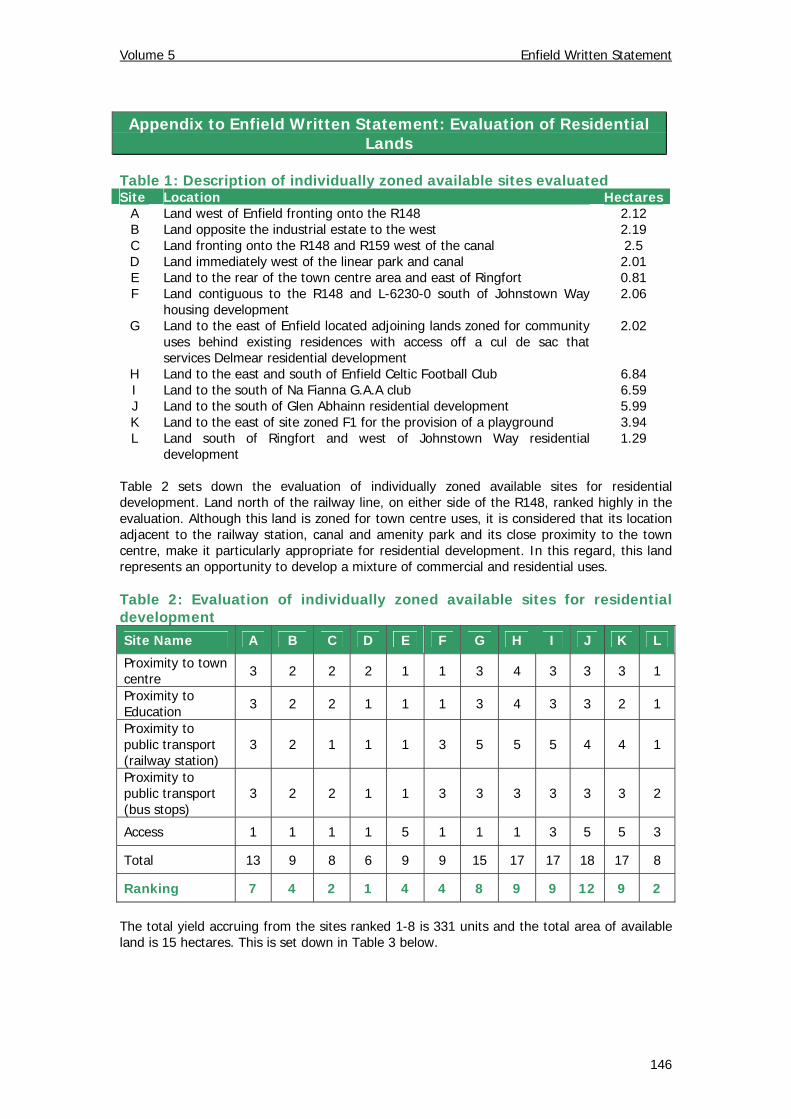
Appendix to Enfield Written Statement: Evaluation of Residential Lands
Table 1: Description of individually zoned available sites evaluated Site Location Hectares
A Land west of Enfield fronting onto the R148 2.12 B Land opposite the industrial estate to the west 2.19 C Land fronting onto the R148 and R159 west of the canal 2.5 D Land immediately west of the linear park and canal 2.01 E Land to the rear of the town centre area and east of Ringfort 0.81 F Land contiguous to the R148 and L-6230-0 south of Johnstown Way
housing development 2.06
G Land to the east of Enfield located adjoining lands zoned for community uses behind existing residences with access off a cul de sac that services Delmear residential development
2.02
H Land to the east and south of Enfield Celtic Football Club 6.84 I Land to the south of Na Fianna G.A.A club 6.59 J Land to the south of Glen Abhainn residential development 5.99 K Land to the east of site zoned F1 for the provision of a playground 3.94 L Land south of Ringfort and west of Johnstown Way residential
development 1.29
Table 2 sets down the evaluation of individually zoned available sites for residential development. Land north of the railway line, on either side of the R148, ranked highly in the evaluation. Although this land is zoned for town centre uses, it is considered that its location adjacent to the railway station, canal and amenity park and its close proximity to the town centre, make it particularly appropriate for residential development. In this regard, this land represents an opportunity to develop a mixture of commercial and residential uses. Table 2: Evaluation of individually zoned available sites for residential development Site Name A B C D E F G H I J K L
Proximity to town centre 3 2 2 2 1 1 3 4 3 3 3 1
Proximity to Education 3 2 2 1 1 1 3 4 3 3 2 1
Proximity to public transport (railway station)
3 2 1 1 1 3 5 5 5 4 4 1
Proximity to public transport (bus stops)
3 2 2 1 1 3 3 3 3 3 3 2
Access 1 1 1 1 5 1 1 1 3 5 5 3
Total 13 9 8 6 9 9 15 17 17 18 17 8
Ranking 7 4 2 1 4 4 8 9 9 12 9 2 The total yield accruing from the sites ranked 1-8 is 331 units and the total area of available land is 15 hectares. This is set down in Table 3 below.
146
Volume 5 Enfield Written Statement
147
Table 3: Yield and rank of residential lands evaluated Site Zoning Land Area (Ha) Density Yield Rank Phase
D B1 2.01 15 30 1 I C B1 2.5 15 38 2 I L A2 1.29 25 32 2 I B A2 2.19 25 55 4 I E A2 0.81 25 20 4 I F A2 2.06 25 52 4 I A A2 2.12 25 53 7 I G A2 2.02 25 51 8 I I A2 6.59 25 165 9 II K A2 3.94 25 99 9 II H A2 6.84 25 171 9 II J A2 5.99 25 150 12 II
1.8
3m F
F
UND
7 9 .2
1 0Kv
7 8 .77 8 .3
Pu mp
7 7 .6
7 7 .8
7 7 .0
1.8 3m F F
7 7 .6
1 .83m
FF
7 6 .0
7 7 .9
7 7 .6
7 7 .9
10 k
v
Ro yal Can al
UND
W e ll
7 8 .9
UND
F
F
CF
1.8
3 m
POSSECKSTOWN
Sp r ing
UND
10 kv
10kv
7 6 .3
7 6 .6
7 7 .3
Delmere
The
Co
u rt
T he D
riv e
CF
10kv
7 7 .2
Bla c k water
Park
CF
7 4 .8
7 6 .0
7 5 .4
7 5 .2
7 4 .9
7 7 .1
7 7 .17 7 .0
Sp o r ts G round
NEWCASTLE WOO DS CR ESCENT
NEWCASTLE WOO DS CR ESCENT
NEWCASTLE WOO DS AVEN UE
NEWCASTLE WOO DS AVEN UE
Area under construction
Newcastle Woods SquareNewcastle Woods Square
Th e
Cl o
se
The Vie w
ES
ES
Rathdale
Co ach yard M ano r
The Park
The A
v enu e
7 7 .6
7 8 .3
CF
Mast
The A
ven ue
Innwood
Po nd
SP
The
Square
Th e C lo se
Th e C our t
10 Kv
Sp r ing
Royal Ca nal
SP
UNDFW
C a r Park
7 7 .9
Bank
H o tel
Bank
7 7 .2
7 6 .3
T
1 0Kv
Pu mp
Po nd
JOHNSTOWN
(ED INNFIELD)
NE
WC
AS
TLE
WO
OD
S D
RIV
E
NE
WC
AS
TLE
WO
OD
S D
RIV
E
Th e Co ac hya rdTh e Co ac hya rd
MoyfenrathMoyfenrath
Gle
n A
bh a
inn
Wa y
Gle
n A
bh a
inn
Wa y
Gle
n A
b ha
inn
Dri
v e
Gle
n A
b ha
inn
Dri
v e
Gl en Abh
a inn
Close
Gl en Abh
a inn
Close
T
Gle n
Ab hain
n Law
n s
Gle n
Ab hain
n Law
n s
Glen A
bhainn Park
Glen A
bhainn Park
Gle n Ab ha inn Gr een
Gle n Ab ha inn Gr een
1 0Kv
Gl e
n A
bhai
nn C
our t
Gl e
n A
bhai
nn C
our t
Sc h ool
School
Gle
n A
bha
inn
Gro
v e
Gle
n A
bha
inn
Gro
v e
Gle
n A
bha
inn
Cre
sce n
t
Gle
n A
bha
inn
Cre
sce n
t
7 6 .8
BM 7 7 .44
W e ll
Gl e
n A
b hain
n A
ven u
e
Gl e
n A
b hain
n A
ven u
e
7 7 .2
8 0 .4
8 1 .6
8 4 .0 Enfield Business Park
8 3 .3
L o dge
8 3 .3
FW
T
C r e dit
U n ion
7 6 .9
Pla tfo rm
UND
PO
7 7 .3
SB
SP
G S
Stn
H e a lth
10 Kv
C e n tre
1.83 m FF
Pla tfo rm
In d u s tr ia l Es tate
7 8 .6
In n fie ld
8 1 .2
8 0 .9
8 0 .4
Po s s e ckstown8 1 .2
H ouse
POSSECKSTOWN
Po nd
CF
1.83 m FF
7 7 .2
7 7 .9
T
7 7 .4
Johnstown WayJohnstown Way1.83 m FF
IN N FIELD
T
SP
FW
UND
UN
D
8 1 .7
8 0 .3
CR
8 1 .4
8 0 .8
Ba y n e field
UN
D
8 2 .6
8 3 .7
7 6 .3
UND
UND
1.83m
FF
UND
1.83 m FF
UN D
1.83m
FF
1.83
m F
F
8 3 .8
8 3 .2
R o y a l Canal
7 6 .5
7 6 .8
T
BM 7 6 .38
7 6 .9
7 6 .2
M 4
M 4
M 4M 4
M 47 3 .4
7 1 .1
7 0 .7
7 2 .7
UN D
UN
D
To wing Pa th
Po nd
ES
Po nd
8 2 .5
8 2 .8
Sp r ing
Po nd
NEWCASTLE
W e ll
8 2 .1
8 2 .3
1.83m FF
1 .83m
FF
2 .6
H1
G1
F1
E3
E2
E2
Sites and Monuments
Access Points
Protected Structures
Amenity Walkways (Proposed/Existing)
Trees to be preserved (1-6)
SPECIFIC OBJECTIVES
Development Area Boundary
Major Distributor / New Roads(Diagrammatical only)
To protect and enhance the amenity of developedresidential communities.A1
B1
F1
G1To provide for necessary community, social andeducational facilities.
To provide for and improve open spaces for active andpassive recreational amenities.
LAND USE ZONING OBJECTIVES
To protect, provide for and / or improve town and villagecentre facilities and uses.
To provide for new residential communities with ancillarycommunity facilities, neighbourhood facilities andemployment uses as considered appropriate for the statusof the centre in the Settlement Hierarchy.
A2
VARIATION MADE on the 19th May 2014
O:\Mapdata\Planning\Forward_Planning\Development_Plans\Adopted County Development Plan 2013\Variation number 2
D1 To provide for appropriate and sustainable visitorand tourist facilities and accossiated uses.
Framework Plan Boundary
E2
To provide for the creation of enterprise and facilitateopportunities for employment through industrial,manufacturing, distribution, warehousing and othergeneral employment/enterprise uses in a good qualityphysical environment.
WLTo protect strategic lands from inappropriate forms ofdevelopment which would impede the orderly expansionof a strategic urban centre