Report Prepared by: ESL MANAGEMENT SOLUTIONS LTD. 20 West Kings House Road Kingston 10 Public Presentation on the Findings of the Environmental Impact Assessment Highway 2000: Phase 1B Sandy Bay to Williamsfield Km: 33+000 to 71+500 Held on September 29, 2007 at: Golf View Hotel, Manchester and Versalles Hotel, Clarendon For: TRANSJAMAICAN HIGHWAY LTD. 8 Olivier Road, Kingston 8 October 2007
Transcript
Report
Prepared by:
ESL MANAGEMENT SOLUTIONS LTD. 20 West Kings House Road Kingston 10
Public Presentation Report ESL Management Solutions Ltd.
Highway 2000: Phase 1B, Sandy Bay to Williamsfield ii
Table of Contents 1. Introduction ...............................................................................................................2 2. NEPA Requirements .................................................................................................3 3. Public Notification......................................................................................................3 4. Chairman and Agenda ............................................................................................12 5.0 Attendance..............................................................................................................15 6.0 Presentations ..........................................................................................................27 7.0 Verbatim Reports ....................................................................................................30 7.1 Verbatim Notes from Manchester Meeting..........................................................31 7.2 Verbatim Notes from Clarendon Meeting ............................................................79
Public Presentation Report ESL Management Solutions Ltd.
1.0 Introduction The Highway 2000 Project (H2K) one of the Government of Jamaica’s landmark Millennium Projects began in 2001, when the Prime Minister of Jamaica announced that Bouygues Travaux Publics of France was selected as the preferred Bidder for Phase I of the project. The first phase of the project was the upgrade of the Old Harbour Bypass, followed by the construction of the Kingston to Bushy Park segment, and then the Portmore Causeway segment. TransJamaican Highway Ltd., (TJH) a specially created subsidiary of Bouygues Travaux Publics is the developer responsible for implementation of the project. The alignment for Phase 1B, Sandy Bay to Williamsfield is currently under consideration for an environmental permit. Environmental Solutions Ltd. (ESL) was contracted by TransJamaican Highway Ltd. to carry out an Environmental Impact Assessment (EIA) as part of the permitting requirements stipulated by the regulatory agency, the National Environment and Planning Agency (NEPA) in respect of the proposed development. As a part of the permitting requirements NEPA requested a public presentation of the findings of the EIA. ESL and TJH decided that two meetings should be held, one in each of the parishes traversed by the alignment. This document is the report on the public presentations of the EIA which were held on Saturday, September 29, 2007 at the Golf View Hotel in Manchester and the Versalles Hotel in Clarendon. The Alignment The alignment begins at the western end of the existing tolled section of Old Harbour Bypass, passing through rolling terrain from KM 34 to KM 44, where the alignment crosses the Rio Minho, parallel to and just of where the existing A2 Road crosses the river. The design speed will be 110 kph. Two Toll Plazas will be constructed, one at May Pen on the ramps of the interchange and one at Four Paths on the main alignment. The alignment continues in a westerly direction and passes just to the south of and parallel to the existing railway line, between KM 51 and KM 57. The alignment continues through hilly terrain and will have a design speed of 90 kph. A vertical gradient of 5.5% is required, between KM 58 and KM 59 to accommodate a change in ground level of almost 100 metres. The existing Melrose Bypass will be incorporated into the new alignment (as this is a contractual agreement with the Government of Jamaica through the Grantor which is the National Roads Operating and Construction Company (NROCC)). The alignment will
Highway 2000: Phase 1B, Sandy Bay to Williamsfield 2
Public Presentation Report ESL Management Solutions Ltd.
continue as a two lane, dual carriageway with a design speed of 90kph. The alignment will cross the railway line, before joining the existing roundabout at Williamsfield. Twenty-nine (29) crossings have been identified and will be facilitated by overpasses and underpasses. These crossings include gullies, rivers, slip roads, local roads, railway and field connectors. The project is scheduled to be concluded 34 months after the commencement certificate has been issued. The project will be divided into phases that will be defined by the construction requirements.
2.0 NEPA Requirements The Public Presentation of the Findings of the EIA was staged in accordance with the NEPA Guideline for Public Consultations, and with communication to NEPA regarding the list of invitees, requisite notification, and selection of the Chairman. Two meetings were staged, although this was not a specific request of NEPA, in order to facilitate the public participation in both parishes.
3.0 Public Notification Public notification was given through the following means: • Public Notification No. 2 -
The Daily Gleaner Saturday, September 8, 2007 The Sunday Gleaner Sunday, September 23, 2007 The Daily Gleaner Wednesday, September 26, 2007
• Flyers - (Distributed to NEPA, NGO’s, GOJ Agencies, Parish Council Offices and Parish Libraries)
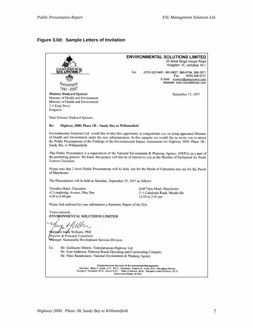
• Personal Invitations (See invitation list) • Town Crier (On the day of the meeting) Additionally, the notice was posted on NEPA website - www.nepa.gov.jm, and ESL website - www.eslcaribbean.com.
Highway 2000: Phase 1B, Sandy Bay to Williamsfield 3
Public Presentation Report ESL Management Solutions Ltd.
Highway 2000: Phase 1B, Sandy Bay to Williamsfield 4
Figure 3.0 a. Public Notification for The Gleaner, Saturday, September 8, 2007
Public Presentation Report ESL Management Solutions Ltd.
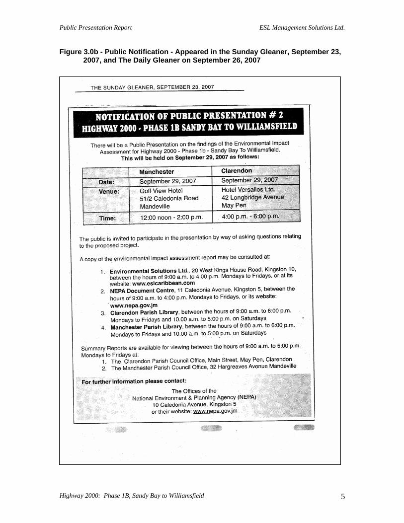
Figure 3.0b - Public Notification - Appeared in the Sunday Gleaner, September 23, 2007, and The Daily Gleaner on September 26, 2007
Highway 2000: Phase 1B, Sandy Bay to Williamsfield 5
Public Presentation Report ESL Management Solutions Ltd.
NOTIFICATION OF PUBLIC PRESENTATION # 2
HIGHWAY 2000 - PHASE 1B - SANDY BAY TO WILLIAMSFIELD
There will be a Public Presentation on the findings of the Environmental Impact Assessment for Highway 2000 - Phase 1b - Sandy Bay To Williamsfield. This will be held on September 29, 2007 as follows: Manchester Clarendon Date: September 29, 2007 September 29, 2007 Venue: Golf View Hotel
51/2 Caledonia Road Mandeville
Hotel Versalles Ltd. 42 Longbridge Avenue May Pen
Time: 12:00 noon - 2:00 p.m. 4:00 p.m. - 6:00 p.m. The public is invited to participate in the presentation by way of asking questions relating to the proposed project. A copy of the environmental impact assessment report may be consulted at:
1. Environmental Solutions Ltd., 20 West Kings House Road, Kingston 10, between the hours of 9:00 a.m. to 4:00 p.m. Mondays to Fridays, or at its website: www.eslcaribbean.com
2. NEPA Document Centre, 11 Caledonia Avenue, Kingston 5, between the hours of 9:00 a.m. to 4:00 p.m. Mondays to Fridays, or its website: www.nepa.gov.jm
3. Clarendon Parish Library, between the hours of 9:00 a.m. to 6:00 p.m. Mondays to Fridays and 10.00 a.m. to 5:00 p.m. on Saturdays
4. Manchester Parish Library, between the hours of 9:00 a.m. to 6:00 p.m. Mondays to Fridays and 10.00 a.m. to 5:00 p.m. on Saturdays
Summary Reports are available for viewing between the hours of 9:00 a.m. to 5:00 p.m. Mondays to Fridays at:
1. The Clarendon Parish Council Office, Main Street, May Pen, Clarendon 2. The Manchester Parish Council Office, 32 Hargreaves Avenue Mandeville
For further information please contact:
The Offices of the National Environment & Planning Agency (NEPA)
10 Caledonia Avenue, Kingston 5 or their website: www.nepa.gov.jm
Figure 2.0c: Flyer
Highway 2000: Phase 1B, Sandy Bay to Williamsfield 6
6. Gordon Spence, (Resident) NWA, 343-9212 7. Vernal Burton, NWA 8. Junior Simms, 19 Denbigh Crescent, 389-2284 9. J. Chung, 537-1388 10. Carlton Crooks, 2 Sharp Avenue, 421-8113 11. Michael Douse, Clarendon Park, 962-3336 12. Mr. Atkins, 393-2829 Ministers of Government, Members of Parliament and Mayors Ministers of Government Mike Henry (Transport and Works)
Rudyard Spencer (Health and Environment) Members of Parliament - Clarendon Pearnel Charles (North Central)
Michael Stern (North West) Rudyard Spencer (South East) Laurie Broderick (North) Noel Arscott (South West) Mike Henry (Central)
Clarendon Parish Council Helene Simpson Councilor for Mocho
Staphel Thomas, Physical Planner Garfield Thompson, D. Supt. Roads & Works Lloyd Samuels, Warehouse Overseer Adessa Morgan - Secretary/Manager Gradlin Fearon, Director of Admin.
Highway 2000: Phase 1B, Sandy Bay to Williamsfield 9
Public Presentation Report ESL Management Solutions Ltd.
Members of Parliament - Manchester Peter Bunting (Central)
Michael Peart (Southern) Audley Shaw (North East) Dean Peart ( North West)
Manchester Parish Council Sean Rowe, Director of Planning
Wayne Mitchell, Deputy Supt. Roads & Works Mr. Winston Palmer - Secretary/Manager
Mayors Leo Hylton Deputy Mayor for Clarendon
Mayor Milton Brown - May Pen Town Sally Porteous - Deputy Mayor Manchester Desmond Harrison - Mayor for Mandeville
Businesses/Private Sector Ms. Beryl Bennett, JHTA – Deputy Executive Director Garrett Williams, Financial Controller, Juicy Beef Ltd., Lot 1 Clarendon Park May Pen, Fax# 904-2631, Tel: 904-2619 Shirnet Lindo, Administration Manager, Juicy Beef Ltd., Lot 1 Clarendon Park May Pen, Fax# 904-2631, Tel: 904-2619 Mark Lankester, General Manager, Century Eslon (Ja.) Ltd., Bustamante Highway Osbourne Store, 987-3871, F# 987-3855 Hotel Astra Golf View Hotel Mandeville Hotel Tim Lancaster, Chairman, Jamaica Bags Ltd., Cnr. Chapleton Road & Howard Avenue May Pen, 986-4015/986-2435 t/f Damian Young & Garth Young, Young’s Pharmacy, Main Street, May Pen, 986-7719 William Shagoury, Managing Director, Sha-Gore Aggregates Ltd., 23 Paisley Avenue May Pen Robert Gore, Director, Sha-Gore Aggregates Ltd., 23 Paisley Avenue, May Pen Brian Doy, Public Affairs & Communications Manager, JAMALCO Mr. George Morgan, Environmental Health & Safety Officer, WINDALCO Mr. Jackie Minott, Chairman, Jamaica Standard Products
Mrs. Andrene Jones, ALPART Courtney Murray, Murray’s Fish Farm, Clarendon Park Mr. Anthony Smatt, Proprietor, Smatt’s Shopping Mall & Trading Towers Mr. Max Leiba, Proprietor, Esso Tiger Mart Mr. Aldo Brown, President of the Clarendon Chamber of Commerce
Mr. Joel Williams, Councilor Toll Gate Division
Highway 2000: Phase 1B, Sandy Bay to Williamsfield 10
Public Presentation Report ESL Management Solutions Ltd.
Local Community Association Mr. Alvin Jones, Councilor May Pen Central Division Ms. Joy Douglas, H2K Corridor Development Planner - OPM Helene Simpson, Councilor for Mocho Mr. Uthell Purcell, Councilor, York Town Division
NGO’s Mr. Peter Espuet, CCAM Ms. Diane McCaulay, Jamaica Environment Trust- Chief Executive Officer
Government of Jamaica Regulatory Agencies Mr. Ronald Jackson, ODPEM - Director General Ms. Shanti Persuad, Jamaica Bauxite Institute Mr. Basil Fernandez, Water Resources Authority – Managing Director Ms. Marcia Douglas, WINDALCO Mr. Roger Smith, National Works Agency NWA – Manager for Technical Services Mr. E.G Hunter, National Water Commission NWC - CEO Mr. Donovan Reid, National Irrigation Commission NIC – Managing Director Jamaica Railway Corporation (JRC) Mrs. Laleta Davis Mattis, Jamaica National Heritage Trust (JNHT )–Executive Director
Mrs. Marilyn Headley, Forestry Department
Highway 2000: Phase 1B, Sandy Bay to Williamsfield 11
Public Presentation Report ESL Management Solutions Ltd.
4.0 Chairman and Agenda MANCHESTER Mr. Lance White, Head of Agricultural Engineering Department, Sugar Industry Research Institute agreed to Chair the meeting held at the Golf View Hotel at very short notice. Mr. Sam Miller, Manager, Manchester Parish Development Committee who had agreed to chair the meeting advised the organisation on Thursday, September 27, 2007 that due to illness, he would not be able to do so.
Highway 2000: Phase 1B, Sandy Bay to Williamsfield 12
Public Presentation Report ESL Management Solutions Ltd.
Highway 2000: Phase 1B, Sandy Bay to Williamsfield 13
Figure 4.0a Agenda for the Manchester Meeting
14
CLARENDON Dr. Eddie Wright, Physician and Businessman, Chaired the meeting held at Hotel Versalles. Figure 4.0b Agenda for the Clarendon Meeting
Highway 2000: Phase 1B, Sandy Bay to Williamsfield 14
15
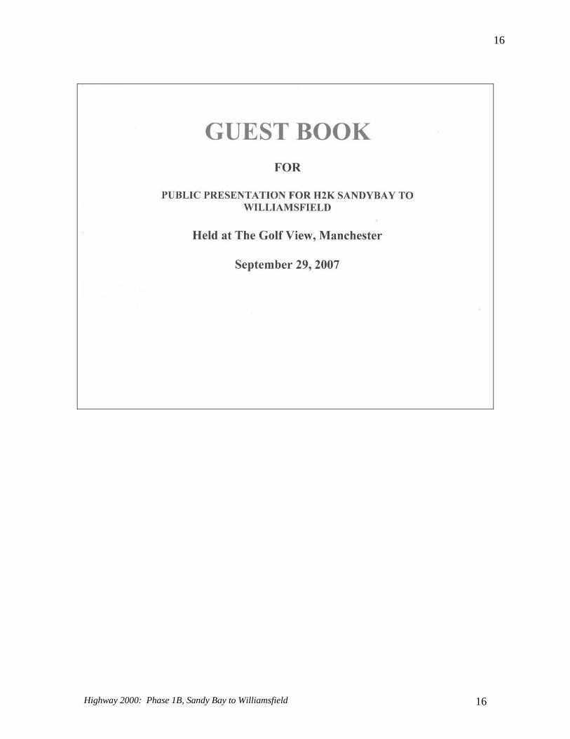
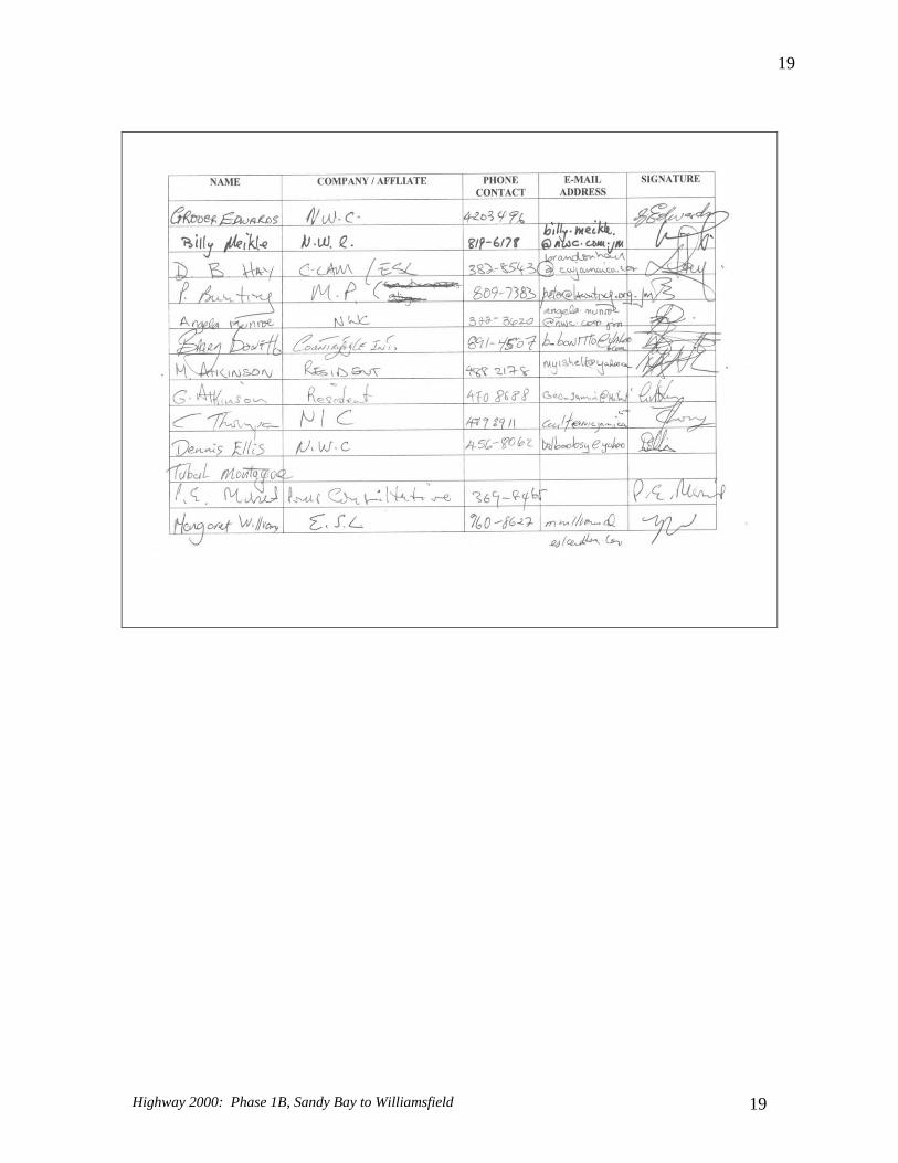
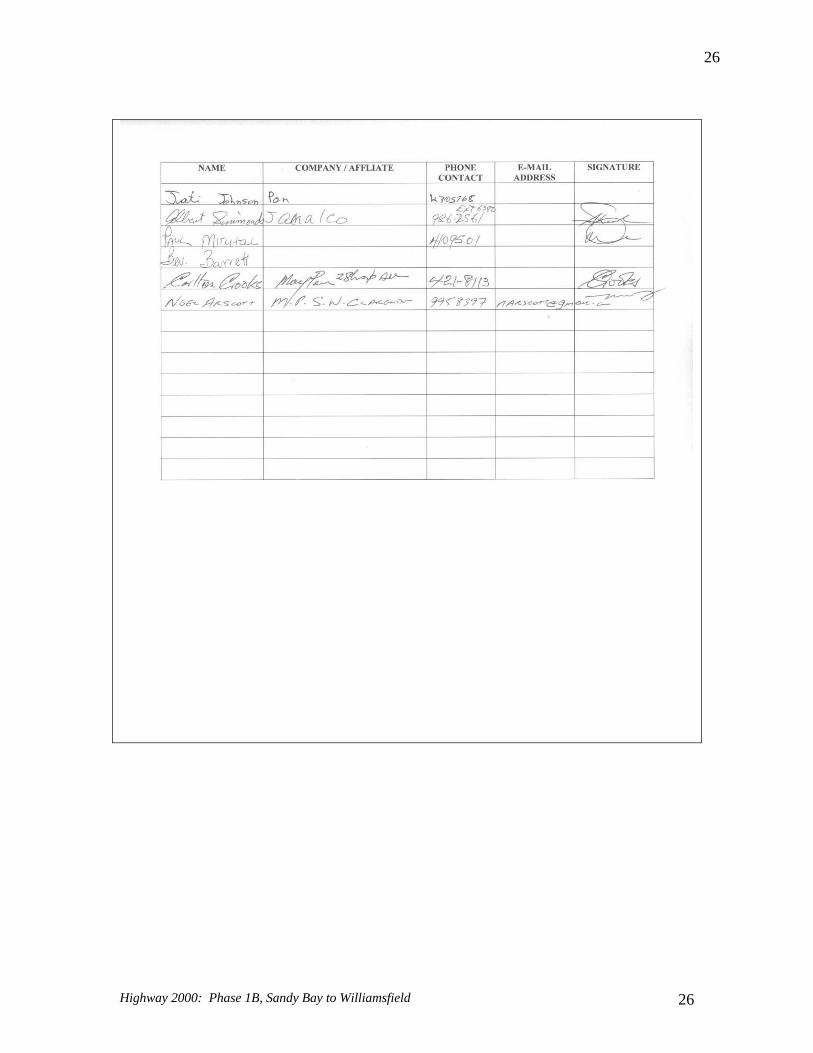
5.0 Attendance In Manchester, 41 persons signed the guest book, although a head count revealed about 50 persons present. In Clarendon, 58 persons signed the guest book, although a head count revealed about 70 persons present. Table 5.0a: Guest Book for the Manchester Meeting
Highway 2000: Phase 1B, Sandy Bay to Williamsfield 15
16
Highway 2000: Phase 1B, Sandy Bay to Williamsfield 16
17
Highway 2000: Phase 1B, Sandy Bay to Williamsfield 17
18
Highway 2000: Phase 1B, Sandy Bay to Williamsfield 18
19
Highway 2000: Phase 1B, Sandy Bay to Williamsfield 19
20
Highway 2000: Phase 1B, Sandy Bay to Williamsfield 20
21
Table 5.0b: Guest Book for the Clarendon meeting
Highway 2000: Phase 1B, Sandy Bay to Williamsfield 21
22
Highway 2000: Phase 1B, Sandy Bay to Williamsfield 22
23
Highway 2000: Phase 1B, Sandy Bay to Williamsfield 23
24
Highway 2000: Phase 1B, Sandy Bay to Williamsfield 24
25
Highway 2000: Phase 1B, Sandy Bay to Williamsfield 25
26
Highway 2000: Phase 1B, Sandy Bay to Williamsfield 26
27
6.0 Presentations Presentations were made by as follows: 1. Presentation of the Project
Mr. Ivan Anderson, Managing Director, National Road Operating and Construction Company, and
2. Presentation on the Findings of the EIA Dr. Margaret Jones Williams, Manager, Sustainable Development Services Division, ESL Management Solutions Ltd.
Copies of the presentations are given in Figure 6.0.
Highway 2000: Phase 1B, Sandy Bay to Williamsfield 27
28
Figure 6.0a: The Project (Power Point Presentation made by Mr. Ivan Anderson)
Highway 2000: Phase 1B, Sandy Bay to Williamsfield 28
29
Figure 6.0b: The Findings of the Environmental Impact Assessment (Power Point Presentation made by Dr. Margaret Jones Williams)
Highway 2000: Phase 1B, Sandy Bay to Williamsfield 29
30
7.0 Verbatim Reports The proceedings of the evening were recorded verbatim by a court reporter and are presented in the text below: 7.1 Verbatim Notes from Manchester Meeting 7.2 Verbatim Notes from Clarendon Meeting
Highway 2000: Phase 1B, Sandy Bay to Williamsfield 30
31
7.1 Verbatim Notes from Manchester Meeting
Highway 2000: Phase 1B, Sandy Bay to Williamsfield 31
32
VERBATIM NOTES OF THE
PUBLIC PRESENTATION OF HIGHWAY 2000 PHASE 1B - SANDY BAY TO WILLIAMSFIELD
HELD AT THE GOLF VIEW HOTEL MANCHESTER, ON SATURDAY, SEPTEMBER 29, 2007
COMMENCING AT 1.20 P.M.
PRESENTERS WERE:
Mr. Lance White Chairman
Mr. Guillaume Dubois TransJamaican Highway
Mr. Ivan Anderson National Road Operating & Constructing Company
Dr. Margaret Jones Williams Environmental Solutions Ltd.
TEAM MEMBERS: TransJamaican Highway Mr. F. Depaepe
Mr. M. Laverne
Environmental Solutions Ltd. Mrs. E. Jones
Mr. G. Campbell
Miss D. Barnes
Miss T. Rodriguez
Mr. B. Hay
Mr. B.Richardson
Highway 2000: Phase 1B, Sandy Bay to Williamsfield 32
Highway 2000: Phase 1B, Sandy Bay to Williamsfield
33
33
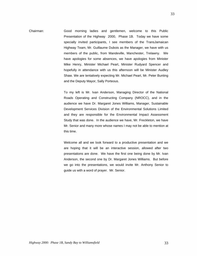
Chairman: Good morning ladies and gentlemen, welcome to this Public
Presentation of the Highway 2000, Phase 1B. Today we have some
specially invited participants, I see members of the TransJamaican
Highway Team, Mr. Guillaume Dubois as the Manager, we have with us
members of the public, from Mandeville, Manchester, Trelawny. We
have apologies for some absences, we have apologies from Minister
Mike Henry, Minister Michael Peart, Minister Rudyard Spencer and
hopefully in attendance with us this afternoon will be Minister Audley
Shaw. We are tentatively expecting Mr. Michael Peart, Mr. Peter Bunting
and the Deputy Mayor, Sally Porteous.
To my left is Mr. Ivan Anderson, Managing Director of the National
Roads Operating and Constructing Company (NROCC), and in the
audience we have Dr. Margaret Jones Williams, Manager, Sustainable
Development Services Division of the Environmental Solutions Limited
and they are responsible for the Environmental Impact Assessment
Study that was done. In the audience we have, Mr. Freckleton, we have
Mr. Senior and many more whose names I may not be able to mention at
this time.
Welcome all and we look forward to a productive presentation and we
are hoping that it will be an interactive session, allowed after two
presentations are done. We have the first one being done by Mr. Ivan
Anderson, the second one by Dr. Margaret Jones Williams. But before
we go into the presentations, we would invite Mr. Anthony Senior to
guide us with a word of prayer. Mr. Senior.
Highway 2000: Phase 1B, Sandy Bay to Williamsfield
34
34
(Mr. Senior offered prayer)
Chairman: Thank you very much, Mr. Senior. We will be trying to conform to a very tight
schedule this afternoon, starting now and we are hoping that at 2:00 p.m. we
should be through with the primarily part of our presentation, as the team
from NROCC and the Environmental Solutions Limited will be going down to
make another similar presentation in Clarendon.
The programme is structured to accommodate Mr. Ivan Anderson, who will
make a presentation of approximately 20 minutes, followed by Dr. Margaret
Jones Williams. There will then be a question and answer session which
should last for about 45 minutes. We are hoping that you will make your
questions as brief as possible, yet effective and comprehensive so that when
we leave here the recording will be done to reflect what we intend to do.
What are the concern of the various community members who are here
today, and how we together can make some sort of compromise to arrive at a
solution that is mutually acceptable to both the developers and the
communities.
So ladies and gentlemen, I would like to welcome Mr. Ivan Anderson. So put
your hands together for Mr. Ivan Anderson. (Applause)
Mr. Anderson: Thank you, Mr. Chairman, members of the Highway 2000 team, ladies and
gentlemen, good afternoon.
Before we get into the actual EIA presentation, what I want to do is to just
familiarize you with the overall Project itself. Tell you a little bit about why we
are doing the Highway 2000 Project, where we are in terms of the phases of
the implementation of the Project, look at the next phase, Sandy Bay to
Williamsfield, and talk a little bit about Mount Rosser to Moneague, the
section from Spanish Town to Bog Walk, and finally wrap up with the phase
that will be going down into Ocho Rios, to give you a full understanding of
the overall Project and the vision of the Project. If you think of the Project
only as a road works Project, then you would have missed the bigger picture,
the Project is about the development of the country.
I don’t know if you can see this very well, this is a map of Jamaica. Over the
next 20 years, where are going? How will Jamaica change over the next 20
Highway 2000: Phase 1B, Sandy Bay to Williamsfield
35
35
years? There are a number of things that we see happening already. If we
look at the northern coast of Jamaica, these are actually all the hotels which
are now being built, actually being built or being constructed within the next
five years on the north coast. We are adding about fifteen thousand (15,000)
hotels rooms and I think everybody is familiar with that number. We have
three million (3M) visitors who now come into the country.
Where are we going to be in the next ten years? Possibly five, possibly ten
million visitors where are the visitors going to go? How will they see Jamaica
will it just be into the North Coast? Apart from those, we have a whole range
of new developments taking place, these are all other additional
developments now taking place along the southern coast of Jamaica. The
attractions which are now being developed, and the industrial developments
that are taking place. What you see happening is a decentralization of the
development in our country. Traditionally the development was focused
primarily on a few major urban centres. What you see happening, is a
decentralization of development, development moving away from the
traditional Kingston, St. Andrew and Montego Bay. What Highway 2000 is
about is how we can actually tie together all of these developments
throughout the country. So here we have the northern leg of Highway 2000
going into Ocho Rios, and here we have the Kingston to Sandy Bay leg and
eventually the Sandy Bay going all the way into Williamsfield.
The Highway 2000 is not just a road Project, it is not about repairing a road,
it is not just about getting from Kingston to Ocho Rios or Kingston to
Mandeville a little bit faster. It is about how we can push the economic
growth of the country and I will talk a little bit more about the expected impact
on the development of the country as we move on.
So, the primary objective of the Project is more than just a road Project it is
about economic growth, catalyst for development, reducing crime and
reducing unemployment and I will talk about some specific numbers in terms
of what we anticipate in terms of employment growth.
It is about providing an efficient and direct link between the major economic
centres of the country, moving us away from the focus on Kingston, St.
Andrew and Montego Bay. It is about reducing the population pressure. No
longer do you have to come and live in Kingston or even live in Mandeville or
Highway 2000: Phase 1B, Sandy Bay to Williamsfield
36
36
live in Montego Bay, you will have an opportunity to live almost anywhere
throughout the country and still commute to these major urban centres.
Finally, it is about reducing the cost of movement of goods and services on
the road.
So where are we in terms of the Project? The first section of the Project was
what we call the Old Harbour Bypass, and that was opened in about
September of 2003, that was followed by the section from Bushy Park all the
way to Mandela Highway and that was opened in 2004. Then the last section
of the Project to open was the Causeway in July 2006. So we now have a
Highway that runs all the way from Kingston out to Sandy Bay in Clarendon.
Does everybody follow where we are now?
What is the next phase? The next phase of the Project is what we are here to
discuss, this is called Phase 1B. The previous section of the Project is what
we talk about as Phase 1A, which is the section from Kingston to Sandy Bay.
And when we talk about Phase 1B, we are talking about Sandy Bay to
Williamsfield. Is everybody on the same wavelength? All of that is what
we called Phase 1 of the Project.
Following that, we have what you called Phase 2 of the Project, and Phase 2
is made up jointly of Spanish Town going into Ocho Rios and from
Williamsfield going all the way into Montego Bay. That is what we call Phase
2 of the Project. Before we get into that, let me tell you a little bit about how
the responsibilities are phased because there is a lot of confusion about who
is Bouygues and who is TransJamaica Highway? What is the role of the
Government of Jamaica and what is the role of Developer?
The obligations of the parties are as follows:- What we have said to the
developer is that we will clear the road, we will buy the lands we will relocate
the utilities from within that corridor, and we will hand it to the developer and
the developer will be responsible for designing the road, building the road,
operating the road, financing the road and handing it back to the country at
the end of the concession period in 35 years 2037.
So the government of Jamaica is just clearing the way, and the Developer is
just putting in the investment, borrowing the money, implementing the Project
and then handing it back to the country in 2037.
Highway 2000: Phase 1B, Sandy Bay to Williamsfield
37
37
What are the next steps then in the Project? As I said, where we are now is
implementation of Phase 1B Sandy Bay to Williamsfield. The Sandy Bay to
Williamsfield leg is approximately 36.7 kilometers starting at Sandy Bay and
ending up at the round-about in Williamsfield. It is similar to what we have
now in terms of the design characteristics of the road, meaning, that it is
designed for 110 kilometers per hour maximum speed with some slow
sections at 70 kilometers per hour. It has maximum slopes of 9% which is
the grade that you see coming up by Melrose Bypass, the steeper section of
the Highway and it is almost similar to what we have now. It is a two by two, it
is a four-lane Highway similar to the section from Kingston all the way to
Sandy Bay. I don’t know if you can see this very well. This is actually a
satellite image of the existing area, but I don’t think you can see it, can you?
What it was designed to do is to show you where the Highway will run. And I
will try and walk you through it.
The Highway starts just about at Sandy Bay just by the end, before you get
to Sandy Bay when you are coming from Kingston, just before you get to that
bridge where it currently ends. So we start there, and we go all the way south
of the existing main road, following our ways through Savannah Cross. Is
everybody with me so far? So we are south of the existing road, go through
the scrub-land, south of the railway line, going towards the west. From
Savannah Cross, we continue going south through Mineral Heights until we
come to the first new toll plaza. So the last toll plaza was at Vineyards and
then we have a new toll plaza now which is right at Mineral Heights just south
of the existing Mineral Heights round-about. Is everybody with me so far?
Before you get to - anybody who knows the area, when you leave the
Mineral Heights round-about going down towards Hayes, you come to the
JAMALCO Great House on the right hand side. You pass Mineral Heights,
and then you come to the JAMALCO Great House, then just before you get
to the JAMLCO Great House we come across the road just about at that
location and there we have a new toll plaza.
From there we continue south of the existing main road, over the existing Rio
Minho bridge, just south of the existing Rio Minho bridge on a new bridge just
pass the two existing mining operations.
Highway 2000: Phase 1B, Sandy Bay to Williamsfield
38
38
Does everybody know where I am now? So we are still running south of the
existing road. This is the Rio Minho, we come over the Rio Minho continue to
run south of the existing main road until we get to just about south of Four
Paths, so we are still just south of the existing road to Clarendon Park, but
we are south of the existing main road. At Four Paths, we make a turn going
north over the existing A1 going towards Clarendon Park. Is everybody
following me so far?
There we have the second toll plaza. From that location we continue just
south of the existing railway line going west, until we pass Juici Beef at
Clarendon Park. At that stage we are now north of the existing road because
we came over the road at Four Paths, went up to the hill and ran along the
railway line until we get to Clarendon Park. From Clarendon Park we go over
the existing hill, we actually follow where the JPS poles are, and when you
are in Clarendon you will notice the JPS poles on the hillside. We go over
the hills, back down the other side just by about where Whitney Turn is,
come back over the existing road, back on the southern side of Porus and
we continue going west.
So we are coming from north, come over by just about Whitney Turn, come
back over the existing main road and then we run in south of Porus just north
of Harmons, north of Red Berry and we join back Melrose Bypass just at
about Trinity. And then from Trinity we continue on the existing Melrose
Bypass widening it into four lanes, incorporating it into the highway and
going all the way down to the Williamsfield round-about. Is everybody with
me in terms of the alignment of the Highway from Sandy Bay all the way
through to Williamsfield.
So quickly, this was just to show you where we hope to go in the future. I
won’t spend much time on how we get from Williamsfield to Montego Bay,
because there has been a lot of talk about how do we avoid Spur Tree, how
do we get past this problems that we have had for the past twenty years?
And so I just did this to show you illustratively where the Highway will be
when we leave Williamsfield.
Currently this is the existing road through Mandeville down Spur Three,
Gutters, Santa Cruise, Lacovia. Is everybody with me that is the existing
road now. Where we go is that we follow pretty much where the existing
Highway 2000: Phase 1B, Sandy Bay to Williamsfield
39
39
railway line is, everybody knows where the railway line is from Williamsfield?
The railway line starts at Williamsfield and it goes through Mile Gully,
through Balaclava, through Maggotty and continues west down into Montego
Bay. So that is where we expect the next section of the Highway to go, and
how we expect to be able to bypass Spur Tree Hill going down that hill.
Finally, let me just wrap up by just quickly taking you through the other
section of the Highway. Starting at Spanish Town, what we do is we go
north just about Chedwin Park, everybody know where Chedwin Park is,
you know where Innswood is, just when you pass Spanish Town just when
you pass the existing plaza, we turn north through the cane piece. We go
through the cane-piece at Innswood, up and over the hill by St. Johns Road,
wrap around the hill by Angels and then we actually follow the train line
through the Gorge up at the higher level. I will show you a little more detail.
From there we bypass Bog Walk and Linstead which is along the existing
bypass which will then be free, so we widen the existing Bog Walk/Linstead
Bypass to four lanes as a free section of the road going all the way down until
we get to the Treadways turn off. Everybody know where the Treadways
turnoff is, just where the existing Bog Walk/Linstead Bypass goes around the
corner where the people sell fruits and just before you get to the train line,
just before, you then turn right, and then we go up what we call the Mount
Rosser Bypass where we actually started building now to Moneague. From
Moneague, we follow the existing road, again widening it to four lanes going
down to Golden Grove. Golden Grove is on the way to Claremont, and from
Golden Grove we have what we call the Fern Gully Bypass and we go all the
way down into Ocho Rio. Everybody has a feel for how we get down into
Spanish Town to Ocho Rios.
Participant: You bypass Faiths Pen?
Mr. Anderson: Yes. So the Highway actually, when we start at Linstead
Bypass now, we bypass Schwallenburg, we bypass Faiths Pen, we bypass
Moneague and we actually end up on the road going towards Golden Grove
you know the area.
Participant: Are you going to accommodate then?
Highway 2000: Phase 1B, Sandy Bay to Williamsfield
40
40
Mr. Anderson: Yes, we are looking at how we can make provisions for
creating a separate Venders’ Arcade on the Highway, it is either on the
Highway or a new one at an intersection. So that is what we call our North
South Link, getting from Spanish Town to Ocho Rios, any questions?
Participant: I did not hear you say toll along that section?
Mr. Anderson: I am sorry, I did not mention toll. Just for you, so the toll
section, the new Spanish Town bypass is tolled. When you leave Spanish
Town, the new Spanish Town bypass, the new George bypass getting into
the Bog Walk round-about that is tolled.
Participant: Are you going to pitch toll from Williamsfield going to Montego Bay?
Mr. Anderson: Yes, I will talk about the free section, but all the sections of the Highway with
the exception of the free sections are tolled, and here are the free sections so
we talked about the new Spanish Town Bypass which is tolled. The Gorge
Bypass is tolled. So when you leave Spanish Town you are driving on tolled
section all the way to Bog Walk round-about.
Participant: You were saying that it would start at Chedwin Park, I am just trying to see
where you connect to the Highway because I was wondering whether you
had the original Old Harbour bypass?
Mr. Anderson: No, not that far. Just by Chedwin Park you are talking about Bushy Park, we
don’t go that far. Just by Chedwin Park, just by the school where the old
Innswood factory is, roughly in that section. So in terms of the North Coast
Link, quickly, the next section is free, the Bog Walk/Linstead Bypass is free.
The Mount Rosser Bypass is tolled. The next section is free which is the
Moneague to Golden Grove and again all of this is of Highway standard now
so it is four lanes, divided carriage-ways, even on the free sections. And then
the final section is tolled from Golden Grove going down into Ocho Rios, so
we have three tolled sections and two free sections.
Participant: Would it be possible if we are going to have so many tolls roads, if I am
traveling from Mandeville to Kingston on the new highway and I could buy
one pass apart from the multiple passes to save stopping and stopping if I
want to get from here to Kingston.
Highway 2000: Phase 1B, Sandy Bay to Williamsfield
41
41
Mr. Anderson: That is why we have tags. So you can use the electronic tags and
you can drive through all the way.
Participant: The leg from Williamsfield to Montego Bay are you going to preserve
what is left of the existing railway infrastructure?
Mr. Anderson: Yes, it does not currently utilize the railway reservation.
Participant: Direct from Williamsfield to linking up with the Sandy Bay?
Mr. Anderson: Yes.
Participant: May I propose that we incorporate the fruit vendors just like how we
do in Faith’s Pen have a spot there?
Mr. Anderson: Right, the vendors’ arcade is part of the Highway and it will be built
as part of the Highway, that is correct.
Participant: The fruit vendors?
Mr. Anderson: The vendors on Melrose.
Participant: No, no what I am saying, we are going to have some social economic
fall out when you put that from the Williamsfield to Kingston. I am
saying give some options to some of the existing fruit vendors on the
way going through Porus just like Faith’s Pen have a lay-by for them
also.
Mr. Anderson: Yes, the facility is, I think it is 20 units, it is 20 stalls, that we are
proposing in the facility. So it is a little bit bigger than the existing
facility so it will allow for additional people.
Participant: So are you going to put the fruit vendors in there?
Mr. Anderson: Yes, so we can accommodate some more people.
Highway 2000: Phase 1B, Sandy Bay to Williamsfield
42
42
Participant: What about lighting, really and truly the existing Highway 2000 is
very inefficient when it comes to lighting up. I want you to explore
the possibility. You cannot have in this modern era, where we want to
improve our infrastructure, we got to put something whether it is a
solar light whatever is needed to be done.
Mr. Anderson: Let me just finish quickly and come back to the question. So quickly,
Mount Rosser Bypass as I mentioned it starts at Linstead Bypass, it’s
a two by two similar to the existing Highway. It starts at the Linstead
Bypass goes all the way around, up the hill bypassing Faith’s Pen,
bypassing Moneague and coming out on the road going to
Claremont, going to Golden Grove. You were asking about Spanish
Town Bypass this is an urban core of Spanish Town here. The
existing Highway runs along the south down here, Chedwin Park is
actually right here, the existing interchange is about right here. So
we start just here just over St. Johns Road, wrap around the top of
the hill, go by Angels, follow the existing train line through the Gorge
over the river just by Kent Village and into Bog Walk. That was
quick, but just to give people a feel for where the road is.
Participant: When you say over the road you mean across Rio Cobre?
Mr. Anderson: Yes, when we leave Angels we are on the left going towards Bog
Walk, we are up on the hill now. So we are much higher up than Flat
Bridge, so we are up at the railway level and we continue at that level
until we pass Kent Village, you know Kent Village that little
community inside the Gorge? When we pass Kent Village, we
come back over the river, it is not a flat bridge because we are
getting a much bigger bridge now, which is not subject to flooding
and then we go back into the round-about. As I mentioned, the
existing road from Moneague goes this way down to Ocho Rios. We
come across the hill, back across the existing road down to Golden
Grove and then from Golden Grove which is down here, we start on
a new alignment through the hills, people who know the area,
through Lydford you know where the old mining operation was, all
the way down into Ocho Rios.
Participant: That is Jacks Hall?
Highway 2000: Phase 1B, Sandy Bay to Williamsfield
43
43
Mr. Anderson: Well, we actually come out just west of the Reynolds Pier, you know where
the Reynolds Pier is. Just a little bit west to Reynolds Pier just before you get
to Dunn’s River, so we come out between Dunn’s River and the Reynolds
Pier back on the existing North Coast Highway. We expect to improve the
travel time by about 60%. But as I said at the beginning, if you think about
the Highway in terms of just roads, just road improvement, just going from A
to B, a little bit faster then you would have missed the bigger picture. The
Highway is about accelerating the GDP growth of the country.
The output we expect from the Highway in the medium term, we expect that
the Highway can generate as much as $26 billion additional to the GDP of
the country in the midterm. If everything else stays the same, if there are no
changes in the other sectors, then that could add as much as 3% GDP point
growth to the economy. We are now doing one, one and half to two percent
(1½-2%) so it could make a big difference on the overall economy in the
medium term. In the long term, an even bigger impact of $34.5 billion
additional on the country’s GDP, 3.7% real GDP growth, 119,000 jobs.
These are not jobs - we are not talking about the construction jobs during the
building of the Highway, we are not talking about the jobs in the toll plazas,
we are talking about the impact that the Highway can have on the overall
economy. 119,000 jobs may not seem like much, does anybody have a feel
for the employed labour force currently? Well, the employed labour force in
2004 was only about 1.19 million people, 1.19 million. So 119,000 jobs if you
could add that, that is almost ten percent (10%) of the labour force, that is a
very significant impact on the unemployment in the country.
As I said, where we are now is that the Developer is finalizing his costing.
We are hoping to start in the last quarter of this financial year to tie up the
financing by the last quarter of this financial year, and to get started by the
first quarter of the next financial year. That is our target for starting work.
Participant: Say it again, Sir?
Mr. Anderson: We expect to start tying up our financing by about the last quarter of this
financial year, that is by about March 2008 and to get started in the next
quarter - the first quarter of 2008. And we are starting with the Sandy Bay
Williamsfield.
Highway 2000: Phase 1B, Sandy Bay to Williamsfield
44
44
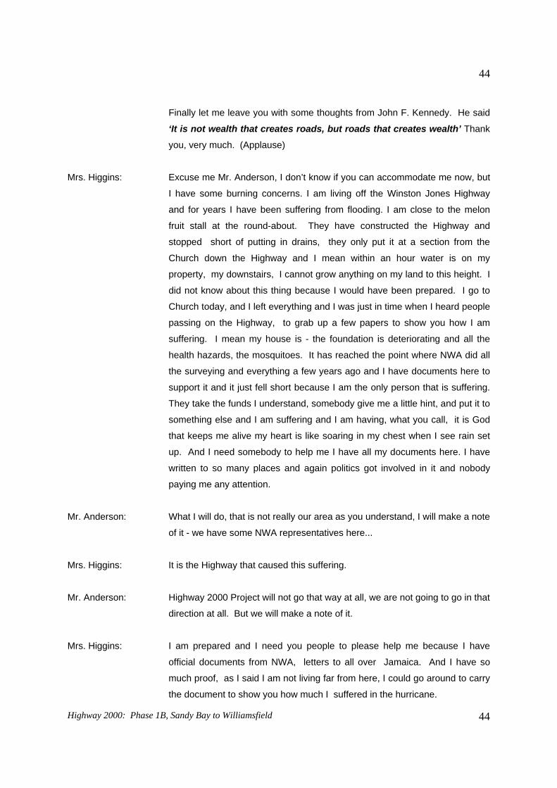
Finally let me leave you with some thoughts from John F. Kennedy. He said
‘It is not wealth that creates roads, but roads that creates wealth’ Thank
you, very much. (Applause)
Mrs. Higgins: Excuse me Mr. Anderson, I don’t know if you can accommodate me now, but
I have some burning concerns. I am living off the Winston Jones Highway
and for years I have been suffering from flooding. I am close to the melon
fruit stall at the round-about. They have constructed the Highway and
stopped short of putting in drains, they only put it at a section from the
Church down the Highway and I mean within an hour water is on my
property, my downstairs, I cannot grow anything on my land to this height. I
did not know about this thing because I would have been prepared. I go to
Church today, and I left everything and I was just in time when I heard people
passing on the Highway, to grab up a few papers to show you how I am
suffering. I mean my house is - the foundation is deteriorating and all the
health hazards, the mosquitoes. It has reached the point where NWA did all
the surveying and everything a few years ago and I have documents here to
support it and it just fell short because I am the only person that is suffering.
They take the funds I understand, somebody give me a little hint, and put it to
something else and I am suffering and I am having, what you call, it is God
that keeps me alive my heart is like soaring in my chest when I see rain set
up. And I need somebody to help me I have all my documents here. I have
written to so many places and again politics got involved in it and nobody
paying me any attention.
Mr. Anderson: What I will do, that is not really our area as you understand, I will make a note
of it - we have some NWA representatives here...
Mrs. Higgins: It is the Highway that caused this suffering.
Mr. Anderson: Highway 2000 Project will not go that way at all, we are not going to go in that
direction at all. But we will make a note of it.
Mrs. Higgins: I am prepared and I need you people to please help me because I have
official documents from NWA, letters to all over Jamaica. And I have so
much proof, as I said I am not living far from here, I could go around to carry
the document to show you how much I suffered in the hurricane.
Highway 2000: Phase 1B, Sandy Bay to Williamsfield
45
45
Chairman: May I intervene here, just to, not to reduce the importance of the points that
are being made but in the interest of time I think we have a Question and
Answer Session, and in the case of this very deep sentiment that is being
expressed I think that we need some very special attention and I think the
recording secretaries who are here today should take note of that.
I think we should take a couple seconds to acknowledge the presence of
Honourable Mr. Peter Bunting here with us today welcome, Honourable
Minister. And we are hoping that we can proceed to the point where we can
have the next presentation following which we can entertain your burning
questions and answers otherwise we might not be through here this
afternoon. I know it is difficult for you to memorize some of these questions
and concerns you have, but if you have a pen and a little piece of paper just
jot down these in brief and try to remember them so that we don’t miss the
point in getting across what we are here about today. We go now to our next
presenter, Dr. Margaret Jones Williams and put your hands together to have
her from the Environmental Solutions. Dr Williams. (Applause)
Dr. Williams: Thank you Mr. White, good afternoon everybody. I am Margaret Jones
Williams, Deputy Team Leader for the Environmental Impact Assessment for
Sandy Bay to Williamsfield.
Before I begin my presentation I would like to introduce the EIA team and
they will be participating in the discussion at the end if you have any
particular question to be answered. I would like to start with Mrs. Eleanor
Jones Managing Director of Environmental Solutions Limited and Hazard
Vulnerability Specialist, Mr. George Campbell, Socio-economic Expert and
Director with Environmental Solutions Limited, Brandon Hay, Botanist and
Zoologist, Brian Richardson, Hydro-geologist, Doloris Barnes our
Environmental Engineer, Teresa Rodriguez GIS Specialist and Romona
Brown our Administrative Officer. As Mr. White said, you will notice two
ladies at the front, they are court reporters and they are recording the
proceedings verbatim which is a requirement of the reporting procedures for
NEPA.
I am going to say a little about the Highway 2000 Process since 1999, and
the environmental process to date for this particular segment of the Highway.
Highway 2000: Phase 1B, Sandy Bay to Williamsfield
46
46
Then we will have a look at the Terms of Reference for conducting the EIA
and the methodologies that we have applied. I will say a little about public
consultations because that is an important part of the requirement. Mr.
Anderson went through the alignment in quite a lot of detail so I don’t think I
need to go back over that, so I will move on and have a look at some of the
relevant legislation and then I will present the data that we collected for the
entire alignment.
After that we will have a look at the impacts or the potential impacts that the
construction operation of the Highway could have and the mitigation
measures that we propose for reducing or minimizing the negative impacts.
We will have a look at the positive impacts and then I will say a little bit about
alternatives that were considered. And then we will look at the cumulative
impacts in terms of this segment of the Highway, the other segments of the
Highway, and other developments and then the way forward in terms of what
happens in the process after today’s meeting.
Highway 2000 began with studies for strategic environmental assessment in
1999. In 2000 the National Environment and Planning Agency, that is NEPA,
which is the environmental regulatory agency issued a letter of endorsement
for the environment process that was applied to Highway 2000. The strategic
environmental assessment is similar to an EIA but it is applied with a more
strategic focus for Projects of a very wide geographical scope complexity in
terms of administrative procedures and in terms of issues.
The Strategic Environmental Assessment was presented at what was the
Bidders Conference in 2000, at which Bouygues Travaux Publics was
selected as the preferred bidder. After that was the establishment of
TransJamaican Highway Limited which is the Project Developer, the Project
Owner and they are represented here today as well.
The Environmental Process to date. The Highway 2000 actually began in the
upgrade of the Old Harbour Bypass and then we did the EIA for Kingston to
Bushy Park for 2002, for Portmore Causeway 2004 and Sandy Bay to
Williamsfield was just submitted to NEPA at the beginning of September.
The way the process works, the Developer, TransJamaican Highway Limited
has to submit an application form to NEPA to get an Environmental Permit for
construction of the Project. After that NEPA requested that an Environmental
Highway 2000: Phase 1B, Sandy Bay to Williamsfield
47
47
Impact Assessment be conducted and requested that Terms of Reference be
submitted. Now, those Terms of Reference were actually distributed to
Agencies and the public, and posted on websites and in Parish Council
offices so that the public would have a chance to have an input into the
Terms of Reference that should be applied. Then we conducted research
and analysis including desktop work, fieldwork, laboratory analysis and then
submitted the EIA Report.
Today we have two public meetings which are a part of the EIA process to
present the findings of the EIA. We looked at the natural environment, the
physical, biological and socio economic components, looking at geological,
hydro-geological features, natural hazards, air quality, noise, water quality,
the biological aspects included the vegetation, the flora, the fauna, the
animals and the habitats ecosystems and parks and protected areas. Under
the socio-economic environment we looked at the demographics:
settlements, livelihoods, cultural practices, archaeological and heritage
features, infrastructure utilities, community services and waste management.
We also had a look at policy and the legislative and regulatory considerations
that should be applied to the Highway and that included the permitting
process as well.
Under the identification of potential impacts: what we do is we look at how
the Project is likely to impact the environment and to look at the
environmental attributes that exists that are likely to impact the Project as
well. Some of these included the landscape modification, potential for
pollution of surface or ground water, air and noise, socio-economic and
cultural impact, land acquisition and relocation, transportation infrastructure
and any impacts on bio diversity.
We also had a look at natural hazard risks and this is a specific path of the
Terms of Reference as requested by NEPA to look at storm water drainage,
drainage during construction, drainage during operation, and drainage
control during the operation phase in terms of crossings, bridges, gullies and
so on.
Public participation: we have had several stakeholders meetings with
government agencies, with individual stakeholders, with property owners, and
communication with NGOs, particularly the Portland Bight Protected Area, as
Highway 2000: Phase 1B, Sandy Bay to Williamsfield
48
48
a small section of the Highway runs through the northern boundary. We had
the first public presentation which was in Clarendon on June 28th, 2007
where we presented the Project and the Terms of Reference to the public so
that they could have a chance to have an input. Then we conducted the field
investigations where they have been ongoing before June 28, and then on
completion of the EIA as I said, to present the findings today.
In terms of the legislation, we identified 27 pieces of legislation that are
relevant to the Project during both the construction and operation phases, but
I would just like to mention some key ones here. The National Resources
Conservation Authority Act of 1991 which is the overriding environmental
legislation in Jamaica and under Sections 9 and 10 of that Act, it speaks to
the need for the Environmental Impact Assessment for developments in
prescribed categories. The Permit and License system was introduced at
NEPA, it was then NRCA in 1997, and that is the mechanism through which
the permitting process is managed. Other legislation includes the Water
Resources Act, which looks at surface and ground water, quality and
quantity, Quarries Control Act, and of course we have the Main Roads Act
and the Toll Roads Act which was implemented for the development of toll
roads and collection of toll.
In terms of the baseline data that was collected and the issues identified,
topographically Sandy Bay to Clarendon Park is generally flat and beyond
that going westward to Williamsfield the route is typified by rolling limestone
hills. The area can be divided into four sections: Sandy Bay to Four Paths,
Four Paths to Clarendon Park, Clarendon Park to Porus, and Porus to
Williamsfield. Various types of soil mostly overlay Newport limestone
formations.
In terms of the geo-technical classification and natural hazard vulnerability: -
the limestone formation range from soft to nodular chalks, to re-crystallized
limestones. There are characteristic drainage features such as sink holes
and there is a flood history in depressions and gully courses along the
alignment. Slope stability is generally good, but landslip risk will increase
along fault lines.
In terms of groundwater and surface water resources, the alignment crosses
two main hydrological basins the Rio Minho basin and the Milk River basin.
Highway 2000: Phase 1B, Sandy Bay to Williamsfield
49
49
Several gullies and streams are also intersected including Shutes Gully,
Webbers Gully and Ann’s Gully also called Jack’s Gully I believe. In terms of
seismicity, the most seismically active section of the island is to the east and
the maps indicate that if there is to be severe activity in the east, depending
on the intensity of the quake, seismic activity could be felt as far west as the
Project area. In terms of flooding, Southern Clarendon and Manchester are
flood-proned areas and this is due to the geological and hydrological
features. Several significant flood incidents have been recorded in the past
and this included May 1993 in Inverness and Shutes Gully, Porus in
May/June 2002 and Harmons in September 2002. Now the ODPEM Flood
Registry, that is the Office of Disaster Preparedness and Emergency
Management, they have a flood registry (and we usually do as part of our
baseline data gathering analysis search the ODPEM Registry), it indicates
that historical flooding is a pre-existing feature for Southern Clarendon and
Manchester.
In terms of air quality and noise, we set up 12 monitoring stations along the
alignment and these are to determine existing ambient levels of particulates
and sulphur/nitrogen dioxide, these are also requirements under the Terms
of Reference. And what this helps to do is to establish the baseline, the
existing conditions so that during the construction phase and during the
operation phase there is something against which to measure any changes in
air quality. The air quality levels are all within standard with the exception of
the Rio Minho area where there are sand-mining activities, and the levels
there are about 12 times the standard.
In terms of water quality, four water quality stations were selected Rio Minho,
Milk River, Rock Halt and Spring Grove. Again the water quality in these
systems are fairly good with the exception of Rio Minho showing high nitrate
levels, possibly associated with farming activity and high faecal coliform
levels at Spring Grove possibly again due to animals in the area.
The Portland Bight Protected Area was established in 1999, and is the
largest protected area in Jamaica. The alignment is just in the northern
section of the Portland Bight Protected Area where the alignment begins at
Sandy Bay and traverses for a very short section before going out of the
Protected Area. The area is managed by Caribbean Coastal Area
Management (CCAM) and NEPA in a co-management arrangement. The
Highway 2000: Phase 1B, Sandy Bay to Williamsfield
50
50
vegetation in this area is influenced by the soil topography elevation and land
use, the area is strongly affected by human activity and is highly disturbed.
Four habitat zones were identified disturbed dried limestone woodland,
abandoned sisal plantation, cane-fields and pastures, rural settlement and
cultivation and both side scrubs. 79 species of birds were observed in
surveys including 11 of the 28 endemic birds that we have in Jamaica. It
says here, “birds were observed or predicted” and this is because our
sampling was conducted during the summer months and so we did not have
the advantage of the winter migrants. But in terms of the literature research,
this was covered in terms of the species that are likely to be expected, so it
speaks to species that were observed or predicted.
No rare, threatened or endangered species were reported the only species of
concern of endangered species and of concern of the Portland Bight
Protected Area is the American Crocodile because the habitat occurred
within the Portland Bight Protected Area. But where the alignment is, it is not
likely that the Crocodile will be found there, although there is a slight risk of
them possibly entering streams and gullies, particularly in the area of fish
ponds.
Okay, the communities found between Sandy Bay and Four Paths, include:
Sandy Bay, Savannah Cross, Hunts Pen, Mineral Heights, Halse Hall,
Curatoe, May Pen Bypass, Fogga Road and Four Paths. This area is a
densely populated corridor and there are communities that have reported
historical flooding including: Sandy Bay, Savannah Cross, Hunts Pen,
Mineral Heights, and lower Halse Hall. The Highway will cross Shutes Gully,
Webber’s Gully, Rio Minho and Jack or Ann’s Gully in this region. The most
important land use aspects are residential, commercial and agricultural use.
In terms of the socio-economic profile - we have low and middle income
communities, limited social facilities, low employment rate. I would like to
comment that I don’t think that this is unique, just the Sandy Bay to Four
Paths based on Mr. Anderson’s presentation, it is a Jamaican phenomenon.
There are large schemes such as Mineral Heights and McGilcrist Pen. As I
said before the flora and fauna is highly disturbed, no threatened or
endangered species, but this is the section in which the alignment falls within
the Portland Bight Protected Area.
Highway 2000: Phase 1B, Sandy Bay to Williamsfield
51
51
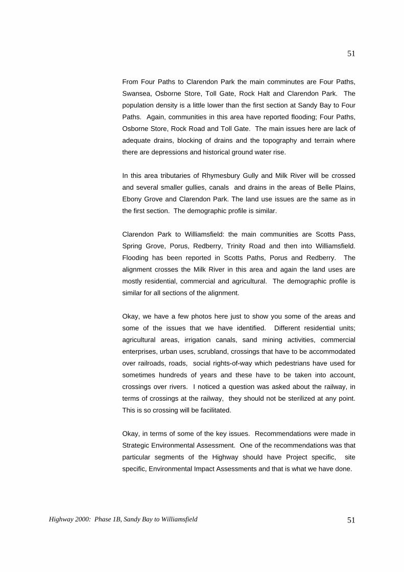
From Four Paths to Clarendon Park the main comminutes are Four Paths,
Swansea, Osborne Store, Toll Gate, Rock Halt and Clarendon Park. The
population density is a little lower than the first section at Sandy Bay to Four
Paths. Again, communities in this area have reported flooding; Four Paths,
Osborne Store, Rock Road and Toll Gate. The main issues here are lack of
adequate drains, blocking of drains and the topography and terrain where
there are depressions and historical ground water rise.
In this area tributaries of Rhymesbury Gully and Milk River will be crossed
and several smaller gullies, canals and drains in the areas of Belle Plains,
Ebony Grove and Clarendon Park. The land use issues are the same as in
the first section. The demographic profile is similar.
Clarendon Park to Williamsfield: the main communities are Scotts Pass,
Spring Grove, Porus, Redberry, Trinity Road and then into Williamsfield.
Flooding has been reported in Scotts Paths, Porus and Redberry. The
alignment crosses the Milk River in this area and again the land uses are
mostly residential, commercial and agricultural. The demographic profile is
similar for all sections of the alignment.
Okay, we have a few photos here just to show you some of the areas and
some of the issues that we have identified. Different residential units;
enterprises, urban uses, scrubland, crossings that have to be accommodated
over railroads, roads, social rights-of-way which pedestrians have used for
sometimes hundreds of years and these have to be taken into account,
crossings over rivers. I noticed a question was asked about the railway, in
terms of crossings at the railway, they should not be sterilized at any point.
This is so crossing will be facilitated.
Okay, in terms of some of the key issues. Recommendations were made in
Strategic Environmental Assessment. One of the recommendations was that
particular segments of the Highway should have Project specific, site
specific, Environmental Impact Assessments and that is what we have done.
Highway 2000: Phase 1B, Sandy Bay to Williamsfield
52
52
Hydrology was mentioned as a key feature for this segment of the alignment
because of the flood history and the need for public consultation because of
the scope of the Project and the national impact of the Project.
Sourcing and transport of construction material, slope stability, cut and fill
requirements, habitat modification. Crossings over the Rio Minho irrigation
canals, streams and gullies. Other issues that have come up, and the issues
have come up through discussions with stakeholders and from the first public
meeting and in the discussions with the EIA team members and the other
professionals that we have had to interact with. The issue of land acquisition
and impact on property, relocation, disruption of existing traffic routes, loss of
business opportunities and that question was already raised, disruption of
social right-of-ways, incorporation of the Melrose Bypass into the proposed
alignment, access to the toll roads, the access points, the ramps and the toll
booths, employment opportunities during the construction phase and the
overall benefit to traffic movement and safety.
Now, when we go on to the identification of the impacts, we try to determine
the significant impacts. We have to look at whether the impacts are major or
minor, if they are reversible or irreversible. Some impacts are reversible after
the short term, medium term or the long term, some are not reversible at all.
There are positive impacts and then there are the impacts in the long term,
impacts in the short term, medium term and of course we have construction
phase impacts and operation phase impacts.
Okay, I want to just go through some of the key impacts that we have
discussed in the EIA report: hydrology and drainage. The designs for the
Highway considers both major and minor systems. For the major systems,
the designs use the hundred year event, meaning that the structure should
be of a size to accommodate events of a large intensity which is for the
hundred year event. The Highway profile must be consistent with the major
drainage features to allow for the free flow of water, all drainage features
should be kept un-obstructed, meaning no dumping of aggregate or blocking
of gullies or drains either during construction or during operation.
In terms of hazard vulnerability, many of these issues pertain to the flooding
in terms of design for a hundred year event. We have noted that the site
preparation and construction schedule should take account of traditional rainy
Highway 2000: Phase 1B, Sandy Bay to Williamsfield
53
53
seasons, so that if aggregate, for example, is stored that it is stored properly
so that if there is a large event everything is not washed down into the
nearest gully.
Engineering design should include the geo-technical considerations for slope
stability.
In terms of air quality. During the construction phase there is usually an
increase in fugitive dust and the recommendation for watering of un-
vegetated areas and unpaved road surfaces. Earth material should be
stockpiled in a way to reduce dust, where possible covered or bermed; and
vehicle transporting material should be covered, and dust masks provided for
workers as required. The impacts on air quality are usually short term for the
construction phase and those usually pass in the operation phase, but we
know that in our adjacent communities it can be quite an issue.
Noise is quite similar in terms of proximity to communities and usually
construction best practices dictates that construction occurs during standard
working hours. We identified what we call noise sensitive receivers which are
communities that are very close to sections of the proposed alignment where
the noise of construction work could be a problem, but there are sections
where the alignment goes through scrubland and there should be no noise
sensitive receivers. Servicing of construction machinery and vehicles is also
recommended because it reduces the noise impact if vehicle are properly
maintained.
In terms of water quality construction activities these can pose a threat to
drainage systems, in terms of spills polluting materials, sediment wash-down
and so there is the recommendation for the deployment of silt screens along
river banks wherever bridge construction is taking place. Again, that is the
standard best construction practices.
The engineering design already incorporates slope stability measures and
reinforcement of bridges to prevent wash-down of material. There should be
proper removal and disposal of any construction spoils during the
construction phase and the provision of portable chemical toilets on the
worksite so that rivers and streams are not used by the construction workers.
Scarring of the landscape and reduction of aesthetic appeal is an issue that
Highway 2000: Phase 1B, Sandy Bay to Williamsfield
54
54
has been raised from the Strategic Environmental Assessment and
throughout the Highway implementation process. This is subjective. Many
people feel that the highway provides the opportunity as a positive impact for
opening up vistas in areas that were not previously accessible so it is quite
subjective as to whether people think that it will scar the landscape or it will
improve the landscape. But in order to prevent scarring of the landscape we
recommend the proper disposal of construction material and spoils, what we
call no side-tipping outside the right-of-way, so construction work should
continue within the right-of-way and nothing should happen outside, no
storage of material, no fixing of equipment, no aggregates, no construction
camps and so on. Everything should be kept in the designated area and at
the end of the construction period, rehabilitation of the work site and
construction camp is required and that is usually a permit condition.
Earth material sourcing and transport, all quarries used should be approved
and licenced entities as far as possible from the current calculations, it
appears that areas that will be cut will have enough material to be used for fill
so that there should not be heavy demand on quarry material. And again
transportation of materials should be in covered vehicles that adhere to the
maximum minimum laden weight.
In terms of flora and fauna, there is usually some landscaping and feeding of
some sections of the Highway which will provide some soil stabilization
functions, but we don’t expect, because of the nature of the habitat, that there
will be severe dislocation of species or modification of the habitat.
Unauthorized encroachment should not be encouraged, and this is
particularly true during the construction phase, where once areas start to be
constructed they become more accessible, then people can then get into
other areas that were not previously accessible and this is really of concern in
the Portland Bight Protected Area, where people might be able to get in to
other sensitive areas. Again the works within the right-of-way are confine so
that habitat outside are not impacted negatively.
In terms of traffic, transportation and access, there has to be proper
scheduling of the construction work and adequate notification where ever
detours are required through communities or to bypass areas. Properly
trained flaggers, along with sign postings, reflective barriers at nights, and so
Highway 2000: Phase 1B, Sandy Bay to Williamsfield
55
55
on, during the construction phase is required so that the traveling public is
not put at risk.
Land acquisition and relocation, some properties have been identified and
communication has started taking place with persons likely to be impacted. I
am looking at Mr. Anderson because that is the responsibility of NROCC.
There is ongoing communication and NROCC will acquire the land as
required so that the Developer can have the lands required for construction.
The Government of Jamaica does not have a resettlement plan, and NROCC
is not going to be involved in relocation exercises.
In terms of business enterprises, the question was already asked about
existing vendors and so on, along the current road will probably lose some
business opportunities when persons get on the highway to get from Sandy
Bay to Williamsfield. Discussions have been ongoing with stakeholders, and
again this area falls with the responsibility of NROCC and have been making
considerations for incorporating a lay-by for the vendors at Melrose Bypass to
facilitate continuation of business opportunities there.
In terms of social right-of-ways and crossings, as I said these are paths that
have been used by pedestrians and communities sometimes over hundreds
of years and the number, type and placement of crossings that should be
provided for the Highway has been identified. Most communities appeared to
be adequately served. We have recommended that discussions should be
on-going with the communities especially if they particularly want to have
additional crossings or additional facilities. But there are 29 crossings that
have been identified in the current design.
In terms of employment, we anticipate that there will be some amount of
skilled and unskilled labour opportunities provided for the surrounding
communities. Workers should be briefed on environmental issues relating to
waste disposal, site-tipping, blocking of drains and so on. Any more
questions about employment I think the Developer will be able to answer.
In terms of public health and safety, I think I have already mentioned
increased levels of fugitive dusts during the construction phase and mitigation
measures to reduce that, in terms of wetting to ensure that communities are
not really at a high level of discomfort. There should also be continued use of
Highway 2000: Phase 1B, Sandy Bay to Williamsfield
56
56
proper signage and flaggers. Fencing of the Highway during the operation
phase will reduce animals crossing which puts commuters at risk. Again
pedestrian crossings will be provided so that people should not be crossing
the Highway.
In terms of archaeology and cultural heritage, no direct threat on
archaeological resources or sites listed by the Jamaica National Heritage
Trust (JNHT). The JNHT has been contacted and they have been provided
with initial information for the Strategic Environmental Assessment. There
are two areas of interest; one is the Halse Hall property near May Pen which
was a sugar plantation, and the community of Curatoes which was reported
to have been a Taino settlement. The Highway does not go through these
areas but they are of interest because they are fairly close to the Highway.
In terms of positive impacts, we expect the generation of employment,
certainly during the construction phase, and as Mr. Anderson said, the
Project is not just supposed to be about the Highway itself, but about the
increase in GDP overtime, improved transportation network, efficiency of
travel, reduction of travel time and the movement of goods. Land use
planning should be a positive impact. Right now developments occur as they
are applied for. With the implementation of the Highway corridors it gives the
regulatory agencies an opportunity to actually plan for the types of
development and the types of applications that should actually be dealt with
both north and south of the corridor.
I spoke before of scenic vistas and aesthetic appeal. I just wanted to say
that in these surveys, the public perception seems to be quite welcoming of
this section of the alignment and they have actually indicated that the current
sections from Portmore to Sandy Bay, of course, are well appreciated and
well used.
In terms of consideration of alternatives, the alignment that we have
assessed for this Environmental Impact Assessment is the alignment that
was presented in the Strategic Environmental Assessment. During that
process a few alternatives were discussed but the alignment as is presented
now, is the one that Mr. Anderson described. As I said before, 29 crossings
have been provided, these include over-passes, under-passes, field
connectors, gullies, passing over railway lines, and local roads to ensure
Highway 2000: Phase 1B, Sandy Bay to Williamsfield
57
57
that the communities are not fragmented and cut off. There will be two toll
booths one at May Pen, and one at Four Paths.
In terms of cumulative impacts, we expect change in land use over time
because there are areas of agriculture that will be taken out of use, some of
the existing communities, and properties may be impacted and so there will
be a little alteration in land use. It will be a cumulative impact as the Highway
continues, from Portmore through to Montego Bay. There will be alterations
of business opportunities this is, again a cumulative impact. Mention was
made of Melrose Bypass and the vendors at Porus, just to say that even
though the Highway provides an opportunity for efficient travel using the toll,
the existing alternate route will still be accessible. Of course there will be
increased access to and from the KMA in terms of travel time and movement
of goods and services.
In terms of the way forward, we are at the end of this meeting and have to
prepare and submit to NEPA the report on the public consultation; any issues
raised, and the questions raised by the public. The public has 30 days within
which to send in any written comments to NEPA. NEPA is currently waiting
on comments from the agencies who are reviewing the Environmental Impact
Assessment. And then we can open up for any questions.
Thank you. (Applause)
Chairman: There you have it ladies and gentleman I think you could not ask for a more
precise and comprehensive presentation by Dr. Williams. We sincerely thank
Environmental Solutions Limited headed by Mrs. Jones who is here with us
today, Eleanor well done. Before we go to the question and answer session I
just want to explain to you briefly what the approach will be. There are some
burning questions, one or two of them escaped already, but what we would
like to be able to do is to ask those persons with questions to come to the
front. We don’t have a cordless microphone, so I will try to repeat the
questions for the presenters and you should target who you wish to answer
the question. Whether you would like Mr. Anderson or you would like
TransJamaican Highway or you would like the Environmental Solutions
Representatives to answer. I don’t know if there are any other suggestions.
But if you have questions you just come forward and then others will join.
Highway 2000: Phase 1B, Sandy Bay to Williamsfield
58
58
The first question we will take from Mr. Freckleton. You could give your name
and the community that you are representing so that we can have it for the
records. First question.
(QUESTIONS AND ANSWERS SESSION) Mr. Freckleton: Thank you, Mr. Chairman, I am Tony Freckleton, Chairman
of the South Coast Resort Board I have a number of questions, I am not
going to take up much of your time. But I do believe that in all fairness we
need a little more advance notice, that is number one. Where ahead of time,
if you go through the draft copy of the EIA, I think we need to do a little better
than that. The fact that we all agree that the Highway is a must, it is a great
Project for Jamaica, notwithstanding that but I think the residents of this area
should be shown a little more respect and efforts must be made to provide
advance notice so that they can come out and participate.
Number two, I noticed in the document that the Government of Jamaica does
not plan to have a resettlement policy for the Highway and NROCC, Mr.
Anderson, you have stated also that you are not considering that. However,
we have learnt some lessons from the Highway 2000. When you cut a
community in two you are going to be inviting disaster for years to come. I
am proposing that NROCC and the Government of Jamaica develop a
resettlement policy. That corridor, all that piece of land adjoining the
Highway should be used for industrial purposes. But, in any event, the land
is going to be much more valuable. You should be able to find a better way
than cutting a community right in two. It is disastrous and you need to
address that. Our Member of Parliament has to go, but I would like to urge
you, Sir, that the Jamaican Private Sector be facilitated as much as possible
in the construction of the Highway. We can find money when we want it, in
other words why should it always be these foreign firms having the thirty-five
years concession on these Highway let us try and work with the Government
to get some cheap money from the local firms, as long as you are qualified to
deal with it. In other words, let’s spend the money, too much of our profits
are being repatriated and we want to keep it down here.
Two more questions and I am out of here, the south coast road that goes
from Milk River down that way has been abandoned, I am going to ask Mr.
Anderson to take over that road because we have to beg and beseech to
Highway 2000: Phase 1B, Sandy Bay to Williamsfield
59
59
have it even bushed from time to time. It is a great alternative if anything
should happen to your beautiful Highway we need to get that road improved.
The other item is the leg from Williamsfield to Montego Bay, when do you
expect it to begin, and just for the record we want to ensure that the yam park
and the fruit venders, I am talking about the fruit vendors in the Porus area,
have provisions been made for them and for access points for them to get on
to whatever you are planning so that you don’t have to go on a long journey
to get to get to the commercial centre on the Highway. In other words, select
a spot on the Highway, put a little road to come where they are, you know
what I am saying, where it is not going to interfere with the traffic and you
name it. In other words, they should not have to come up on the Highway
here and pay a toll and then come off at a different location, it is just a
suggestion.
I hope that you will take into consideration the lighting problem, the lighting is
critical so you can spend all these billion of dollars on these lovely roads but
find some more and put in some lighting and let us be proud of it. Like the
Highway in Toronto which is well lit. Thank you very much. (Applause)
Chairman: Okay, could we have a response?
Dr. Williams: Thank you Mr. Freckleton. I will take the first response and then Mr.
Anderson will take the other.
In terms of the notification, I appreciate your concern but I just want to say a
little bit about the process. As soon as the EIA report is submitted to NEPA
we have to give a three weeks (21 days) mandatory notification period to
allow the public the opportunity to review the documentation and come
prepared for the meeting. So this was done, and there were three ads placed
in the newspaper, we have issued invitations, and fliers have been sent to the
Parish Council office, the Parish Library and the NEPA website. So we have
tried to get the word out, but just to let you know that you have 30 days after
today to send in comments, so if you are able to access the ESL website you
may download the documents, and on the issues raised here today that you
have an opportunity to go through the document in some detail and send
your comments in. But in terms of the notification we have adhered to the
procedures as outline in the NEPA guideline for hosting public meetings.
Highway 2000: Phase 1B, Sandy Bay to Williamsfield
60
60
Mr. Freckleton: For this afternoon, for this meeting if we have had copies of the document we
could have prepared ourselves.
Dr. Williams: The documents are in the Manchester Parish Library, the Clarendon Parish
Library, on the ESL website and also the NEPA website. There is also the
summary report, the executive summary is at the Manchester Parish Council
Office and the Clarendon Parish Council office, but the full reports are in the
parish libraries, and have been there for the last three weeks.
Participant: I have seen them.
Dr. Williams: You have seen then, thank you oh good.
Mr. Anderson: In relation to the resettlement policy, let me just outline the process that we
are going to go through. As Margaret mentioned, the first thing we did was a
Strategic Environmental Assessment which meant trying to look at where the
communities were and trying to see how we can minimize the impact of the
road on the communities. So in that way we started to try and minimize the
issues of cutting through communities and cutting off communities, having
said that, there are still going to be some houses that are going to be
impacted. The process is as follows: we have an independent valuator who
is now out in the field gathering information on the value of existing property
in the area and from that they establish a value for the property. That is the
value that we use and we expect to offer the person who is going to be
impacted compensation on that basis. If the person does not agree, if we
cannot come to any mutual agreement, then we go to the next stage which is
what we called ‘compulsory acquisition’, which goes through the
Commissioner of Lands.
The Commissioner invites all the parties, hopeful we don’t
get to this stage, but the way it works is she invites in all the parties she
listens to the parties’ concerns regarding the assessments which were done.
What other information the parties may present, in terms of their own
assessment of what they think their property is valued at, and she then
makes an independent ruling as to what is to be paid for the property. Failing
all of that, then the next step is to go to Court, but we hope it don’t get there.
So as I said, we start with market value for properties and we compensate
Highway 2000: Phase 1B, Sandy Bay to Williamsfield
61
61
people based on these market values. In terms of Milk River, and the road
going down to the south coast I thought that was a very important link
especially for the new Minister of Transportation who has a lot of interest in
the Vernon Field Development. In fact, in our meeting with him he has
already asked us to look at the link from the Highway all the way down to
Venom Field to see how that can be improved as part of the development
that we are doing.
Williamsfield to Montego Bay, we don’t currently have a timeframe now for
the implementation of that phase. The Developer will be reviewing the traffic
numbers because it is going to be based on how much traffic we have, how
much the toll can pay for the Highway and therefore whether additional
subsidies or funds are going to be required from the Government of Jamaica.
In terms of the vendors on Melrose, to the extent that we can incorporate
them in the facilities that we are doing then the fruit vendors would be
incorporated. It is not going to be possible to incorporate all of them but to
the extent that we can incorporate some of them into the facility then we will
do that.
Finally, in terms of the lighting let me just explain the principle that we have
adopted for the lighting of the Highway and it is similar to the principles that
are used in Canada and the US. Where we are going into an urban area, or
where we are going into a toll plaza, or where we have an exit then we have
light, at least we have light posts with light on them. In the rural areas there
are no light posts or there are no lighting and that is the principal that we
have adopted. So, for example, when we are going into the existing Highway
the Old Harbour Bypass, the old intersection, the Old Harbour Bay
intersection is lit. The ending of the Highway should be lit by Sandy Bay, the
ending of the Highway should be lit going into the plaza at Spanish Town and
going into Mandela. The rural areas where we are going through green field,
through the scrublands, then those areas are not lit and that is the principle
we are going through.
There is some difficulty that we are having right now in terms of the actual
lights, we have some lights that are up, some poles that are up without light
and that is an issue we are trying resolve with the developer. Finally, the
Highway 2000: Phase 1B, Sandy Bay to Williamsfield
62
62
question of the repatriation of profits I don’t know if it is something that Gary
wants to handle but....
Participant: I said the question of allowing working with the Jamaican private sector to
give them a chance.
Mr. Anderson: Okay, that is an issue that came up in the previous consultation and we have
been having some discussions with Bouygues, the Developers and the
contractors, to see how we can bring more of the local businessmen and the
local contractors into the process, so that is an ongoing discussion that we
are having.
Participant: And even the ownership thing, get a share of the 35 year
return that is what we are talking about.
Mr. Anderson: We can talk after there are some possibilities for equity as well.
Chairman: Are you satisfied, Mr. Freckleton?
Mr. Freckleton: More than satisfied.
Chairman: Okay, next question.
Mrs. Higgins: My name is Beverly Higgins Montague, but it is Higgins on all my
correspondence. I have been suffering as I told you for about fifteen years
with this flooding from the Highway. I know you are not dealing with my leg of
the Highway, which is the Winston Jones Highway, but I have
correspondence from your office where I was promised that they would put
the drainage in place and this is about four years ago and it is now
deteriorating. I am going to give you copies so that you can copy it, Mr. Keith
Brown, Mr. Patterson and Mr. Roger Smith all these people at the NWA head
office had me like a scape-goat twisting around their fingers. I need you Mr.
Anderson to help me now, because Mr. Patterson promised me that after the
hurricane something would be done. On the New Green Road, not far from
me, those people are suffering from water problems, but only minimally. But I
am really up to my neck and they put in place a new drain. I think, because I
am the only person suffering and there are many returning residents in that
scheme, the same thing that they are suppose to do and the distance that the
Highway 2000: Phase 1B, Sandy Bay to Williamsfield
63
63
drainage is suppose to go on the Winston Jones Highway across from the
fruit stall at the New Green round-about is the same distance.
Anyway, I spoke to Mr. Patterson after the hurricane and he told me that the
next project it will be my Project but I have been getting this for donkey years.
So Mr. Ivan Anderson I am begging you, Sir, to deal with this situation
because it is - I cannot explain - if you saw the video, if knew about this I
would have a basket full of videos and pictures to carry and give you. But
we are Seven Day Adventists and we rushed out when we heard them
passing on the Highway and I had only time to go and grab up a few
correspondence. Please help me. I am giving you my number and everything
afterwards. Thank you.
Chairman: Okay, I think that is clearly expressed and I think we emphasized with Mrs.
Higgins and we are hoping that some solution will come one way or the other.
We will take the another question.
Mr. Douce: My question really is with regards to the land acquisition, I am Mr. Douce one
of the affected property owners. I have met with Mr. Anderson already and
now I have studied this EIA briefly, and I noticed what it says in response to
the land acquisition. They have committed to contact the relevant persons
within a reasonable time. Now my concern is, I have not been contacted, I
don’t know anyone who has been contacted. Actually, we were just going
through the papers and we saw the diagrams and realized that this thing was
running on our property. I am trying to ascertain when will this land
acquisition begin, since we cannot stop the process we will expect to be
compensated financially. When will we be compensated and how can we
notify the other 400 property owners? I mean, I feel the reason why we
have a small turn out is because a lot of people who own property did not
even know that this thing is actually going on their property unless they did
some measurements, and look on the diagrams that is one of my main
concerns. When will we be compensated mainly, and when will we be
notified? That to me is a burning issue. I mean we have owned our
properties for years and we have taken care of our properties and we have
paid our taxes. For us to just wake up tomorrow morning, or wake up one
morning and see a drawing in the paper showing that they are going to take
our property and do it. I think the process has not been done applicable to us
the real tax payers, if you can address that point.
Highway 2000: Phase 1B, Sandy Bay to Williamsfield
64
64
Mr. Anderson: Thank you Mr. Douce, as I indicated when we met with you, we are not even
quite sure that we are going to impact on your particular property.
Mr. Douce: But your drawing is running right in the middle of one of my properties.
Mr. Anderson: But in terms of the general impact, Sir, it is not going to be the situation
where you wake up one morning and we have a tractor on your property, that
is not going to happen.
Mr. Anderson: Before we go on your property...
Mr. Douce: You cannot say that is not going to happen. I am saying April 5, I can give
you dates, April the 5th I opened the newspaper and I saw an ad, Phase 1 of
Highway 2000 and a diagram showing the route. Now, I just use my
information and measurement and I found out that this was running right
through the middle of one of my properties. Now, from April until today
September 29, I drove to Kingston and I was confirmed that it was going
through, but nobody has contacted me or any of the other property owners
that I know who has equal right and I am concerned.
Mr. Anderson: I understand your concern and let me back up a bit. It is not going to be the
situation where we have a tractor on your property and we have not
contacted you and we have not made some effort to compensate you, that is
not going to happen.
What is happening right now, after the meeting you can look at the map. The
alignment is not tied down on ground we have an illustrative alignment, but
even with that illustrative alignment there are slight adjustments that we can
make especially when there are buildings or where there are properties that
you don’t want to be impacted. We can adjust the alignment slightly south or
slightly north in order to avoid them. So we don’t actually have pegs on the
ground showing exactly where the Highway is going. What you have is an
illustrative location for the Highway. As we go on, I mean over the next few
months when we detailed the actual design on the road, some of the issues
that Margaret mentioned in terms of environmental assessment, the hydraulic
assessment, we will get more definitively to detail where on the ground the
Highway is going to go. When we get to that stage then we will be better
Highway 2000: Phase 1B, Sandy Bay to Williamsfield
65
65
able to tell how much of your land we need, is it 5,000 square feet or is it your
entire property or whether we be able to by-pass your property. So, we
envisage that over the next few months as we indicated, we will not start
construction until possibly around April next year, and therefore over the next
six months we expect to better define the actual persons who are going to be
impacted and begin to make contact with them and put in place
arrangements to compensate them. We are not going to end up on your
property tomorrow Mr. Douce without having had discussion with you, and
without having gone out with you, put down pegs on the ground...
Mr. Douce: I am still not satisfied.
Mr. Anderson: Mr. Douce, even with your discussion with me in the office?
Mr. Douce: I have studied this EIA, this thing has impacted my family quite a bit so I have
done a lot of homework. I have seen the compulsory acquisition line that is
on the chart, I have seen where it has impacted on people’s property. My
question is why has nobody contacted us? This is the thing I cannot
understand, to tell me that you will contact us over a period of time is one
thing, but we are the property owners. We cannot sell our property, nobody
will buy it, they say the Government will take it. I want you to look at our
dilemma. We cannot make any investments on our property because you
are going to take it sometime down the road. Where do we as property
owners have our rights to get - we spend our money and buy the property
where is the communication, this is what I cannot understand.
Chairman: Okay, your point is well taken, Mr. Douce, and we all here share your
concern and I think you need also to bear in mind what Mr. Anderson has
been trying to explain to you that whatever is being said is just tentative. I can
attest to that because I have been involved in projects in Clarendon and
when I see tentative proposals on a scale of 1:200,000 or 1:300,000 it looks
much different from when you look at it at a scale of 1:5,000, I can tell you
that. So I think you need to work with Mr. Anderson and to make sure that
whatever he is doing is understood and accepted by both of you.
Mr. Douce: But Mr. White I am not asking you, I have already done the work and it is
running right through the middle of my property. I am not against the
development, my question is when will you people communicate with us?
Highway 2000: Phase 1B, Sandy Bay to Williamsfield
66
66
Chairman: Okay, that point is also taken Mr. Douce, and the question is already
recorded and some response will be forthcoming to you, once your name is
on the list of the contacts I see here. And if it is not there I think the recording
secretaries here will do us the honour of getting it done properly, Mr. Douce.
Mr. Douce: Secondly Sir, I noticed in the EIA there is nothing stating human effects, what
effect is this is having to us as humans.
Chairman: Okay that point again, Mr. Douce, the human component I think with all
honesty...
Mr. Douce: You are talking about structures, roads, buildings...
Chairman: With all respect to you, Mr. Douce, I think that was somehow addressed if it
is not adequate I think there is also provision for them to expand and that
point will also be taken in careful consideration. So in the interest of time can
we move on to another question?
Ms. Munroe: Good afternoon, I am Angela Munroe from the National Water Commission. I
did not see in the presentation, and I have not read the report so please bear
with me. I have not seen in the presentation, where you addressed any
ground water resources, the impact the ground water resources if any?
Chairman: Okay, we will have a response from Dr. Williams.
Dr. Williams: Yes it was addressed but I am going to ask Mr. Richardson, Brian our hydro-
geologist to say a little bit more in terms of the ground water resources and
potential impact.
Mr. Richardson: In terms of the ground water impact, there should not be any damaging
impact from the construction of the Highway because there is a clay layer as
well and that will give it sufficient protection and the aquifer, I think that the
NWC uses, is in the limestone which is another 300 feet beneath the aluvium,
so it would not affect it in any way. Any run-off that is going to be coming off,
I believe they are going to have a catchment system in place to ensure that it
goes through sufficient infiltration before it goes into the ground. The sink
Highway 2000: Phase 1B, Sandy Bay to Williamsfield
67
67
holes, they are looking at it right now to make sure that they don’t block any
or get to close to any.
Chairman: Next question.
Mrs. Atkinson: Good day, I am Michele Atkinson, I am a resident of the Mandeville area and
I am interested in this Project. But in reading through the Environmental
Impact Assessment one question I had was on monitoring aspect of the
environmental impact. In terms of the days that were taken to do the
assessment I think there were two days for sampling with the water, for the
birds it was basically one morning from 9:00 to about 10:00 and in the
presentation today you mentioned that the winter migration birds were not
included. So with this Project going on its course, what plans are in place to
actually do monitoring for the actual environmental impact air, animals
everything during that time. This is in the case where the Highway actually
will be splitting an area. I did not see anything in there that will say how that
will be managed. Also, the rainy season impact - studies were done during
the rainy seasons now we are entering the heavy part of the rainy season
how does the flora and fauna actually change during that time and is there
any impact on the Highway proposed.
The other aspect basically of question one - the second part, the
Environmental Impact Assessment, there were alternatives mentioned for
each leg and at the end of the report they have sections which say for
particular sections we have alternative A, B and C and then in the report it
says C would be preferred. What was not clear in the report is if C would
actually be included as part of the Highway development. So are we not
quite sure about that? The lady before asked about pollution of groundwater
but I think that has been answered.
And the last part is lessons learnt from the first leg of Highway 2000. Say for
example, if we are doing a Project in the country and we go to do a similar
Project somewhere else then the thing that you look at in the communities do
we learn anything from that. The way we did the construction in terms of the
noise, is there anything we can learn from that. I did not see anything in that
report that could capture lesson learnt and that is always good to see. What
did we learn from the one before?
Highway 2000: Phase 1B, Sandy Bay to Williamsfield
68
68
Chairman: Okay, I think those three points were clearly stated and I cannot emphasize
the importance, I think Dr. Williams may have a response here.
Dr. Williams: Thank you, I may have to come back to you to make sure I got the questions
right. The first one about the monitoring is a valid question. We have
recommended monitoring which is included in the Terms of Reference, what
we call an Outlined Monitoring Plan, which deals with water quality, air
quality, construction practices and so on. That is in the document and it is
usually an outlined plan. The monitoring programme cannot be prepared
until after the permit is issued by NEPA where the NEPA issues are also
outlined, so there is usually for construction Projects and it has been done
for the Highway, a detailed monitoring plan which is implemented during the
entire construction phase 12, 24, 36 months and it will include rainy seasons,
dry seasons and monthly. In fact NEPA usually asks for weekly or fortnightly
in the initial stages so it is quite a detailed monitoring during the construction
phase.
Mrs. Atkinson: That is fine in terms of development, but one of the points in that document
was that it talks about baseline and that is what worries me. Where is the
baseline data, and if this is going to be baseline data then I am a bit worried
that I am missing out on the rainy season especially with the water quality.
One day it was high, and the next day it was low. So where are we? Yes we
have to go through the whole activity so I think they are missing the data ...
Dr. Williams: So you are talking about the baseline data?
Mrs. Atkinson: Yes, the report speaks of the baseline data.
Dr. Williams: The baseline data is captured in the report for certain parameters. So you
are just saying that what we are monitoring against, you would like to see
more data. Okay and this is actually included in what we call the limitations
of the report. We do acknowledge where the deficiencies are, and one of
them is the fact that water quality data is only taken over two days during a
particular season so it does not capture, for example, the rainy season. I
have spoken about the winter migrants so at least we acknowledge those -
but we still will do the monitoring which will provide continuous data.
Highway 2000: Phase 1B, Sandy Bay to Williamsfield
69
69
Mrs. Atkinson: Because in my experience with projects because I am working from the
industry side, if I start a Project and I look at my baseline and that data was
not there ...
Dr. Williams: Then you have to monitor again.
Mrs. Atkinson: So from the society’s point of view we need to get that. It is rainy season
now, we need to know what the flooding profile is like, stuff like that.
Dr. Williams: Well, in terms of that information, there is a little bit more on that for example,
the ODPEM flood history is over a series of years so there is rainy season,
dry season, sporadic events you know, so all of that is there and that also
included in the baseline. But the point is taken about where there maybe
gaps in terms of the data set. The other question you had before lessons
learnt?
Mrs. Atkinson: The way the Highway is set, it is in an environmental area, with the
Highway...
Dr. Williams: You mean the fragmenting of habitats?
Mrs. Atkinson: Yes.
Dr. Williams: Okay, what we call it is fragmentation of habitats and it also works for
communities that was also mentioned. But in terms of the habits described,
none of them are considered sensitive ecosystems or particularly sensitive
habitats, they are all secondary modified vegetative communities and are
highly disturbed. The railway line has been there for over 200 years so the
species that are there are pretty adaptable.
Mrs. Atkinson: The railway line is not fenced in. There will be a greater impact with the
Highway than it was with the railway.
Dr. Williams: Yes, but we are just here talking about the level of human disturbance, it is
not pristine forest, that is the point I am making. But in terms of the habitat it
is not a particularly sensitive habitat.
Mrs. Atkinson: It is not very sensitive but you can not leave out those that are there.
Highway 2000: Phase 1B, Sandy Bay to Williamsfield
70
70
Dr. Williams: No, but the point is that, there is such a high level of human impact and
disturbance that a little more disturbance does not make a great level of
difference, I see Brandon putting up his hand, and for example if this
Highway were run in...
Mr. Anderson: Cockpit country...
Dr. Williams: Don’t even mention Cockpit country. (Laughter) But yes, in Cockpit country,
but it is a highly disturbed area. I am going to let Brandon say a little bit more
about that. But the point is taken, the concept is called fragmentation of
habitat. Also just to say something about the type of species that we have
here in Jamaica. Fragmentation of habitat is a little bit more of a concern in
other ecosystems where you have animals like monkeys that need to cross,
like bears or deer. We don’t have those species, and in particular
development Projects sometimes ropes are drawn, canals, or tunnels are
built to ensure habitat continuity. But we have not recommended that in the
EIA because our species don’t require that. The main species of concern for
us are highly mobile species like birds, but I am going to let Brandon say a
little bit more about that.
Mr. Hay: Thank you Margaret, I am not sure if it was not clear but certainly the
biological assessment was not done over two days. The bird counts and the
botanical samples were done at least over five days and that included two
nights to study night-time birds. It is a fact that all of the sampling was done
during the summer months when we did not have the winter migrants around.
But what is presented as the baseline data would and does include winter
migrants. We did not only use the data that we collected in the final lists, we
had additional sources of data as well as our knowledge of data that was
collected in areas similar to the existing corridor and so the list is fairly
complete. It does include most, if not all, of the winter migrants that you
would find. The problem with birds is that because more than half of the birds
in Jamaica are migratory at some point in the year, there are some species
which will just be crossing the Highway on the way from point north to point
south and therefore even if I was to sample every single day for the year I
would still miss them. But most of the birds that would reside there during
the winter have been captured in the report because there were other
sources of data that were included. There were five days of sampling but at
Highway 2000: Phase 1B, Sandy Bay to Williamsfield
71
71
least two days before for collecting of information and desks-top study. Those
things have been included in there as well.
Chairman: Okay, I don’t know if those answers were adequate.
Participant: Those are fine.
Chairman: Okay and there is one last burning issue I think it has to do with lessons
learnt.
Dr. Williams: I wanted to say something about lessons learnt. We have been working with
the Highway 2000 Project since 1999 and in fact just looking back at the
Strategic Environmental Assessment and subsequently the EIA that the
Project team has incorporated the lessons learnt in terms of the application of
our methodology, in terms of the report writing, public consultations and so
on. But I think it is a valid point that I think the report could include a section
on lessons learnt, so I do take that point and just to let you know that there
has been continuity that we have incorporated for example, on June 28th
when we had that first consultation to present the Project and to present
Terms of Reference, that had been done for the previous segment, just
because the public had said they wanted to hear about it a little bit earlier on.
Even though that was not a requirement of NEPA, the Developer agreed to
do that. So we have incorporated the lessons learnt, but I think it is a valid
point that we can include a chapter in the report to show how we have
incorporated both the regulatory agency recommendation as well as the
public comments overtime, that is a very good comment.
Thank you.
Chairman: Okay thank you Dr. Williams next question.
Ms. Morgan: Good afternoon, I am Karen Morgan, if it is proven that residents are affected
by the developments of the road, affected with respiratory disorders, will they
be compensated for that? And number 2, we know that Harmons and Porus
are flood prone areas, okay and we know that water destroysroads. If you
construct those roads and they deteriorate how are you going to rebuild it or
what are some of the measures that you re going to put in place to prevent
that?
Highway 2000: Phase 1B, Sandy Bay to Williamsfield
72
72
Chairman: I think these are two distinct questions one for Dr. Williams and one for Mr.
Anderson.
Mr. Anderson: Well, the first question in terms of the adverse impact of dust or any other
pollution impacts from the construction, that is something that we hope will
not happen and that is why we are doing the EIA, and that is why we are
trying to mitigate all those impacts. If they are as a result of the Highway,
then the Highway will have to take responsibility for it. In terms of the road,
you are specifically asking me about Harmons Road? In terms of the
flooding? Okay, what we have done, the Highway now passes south of
Porus, it passes south of the main road just north of Harmons and south of
Porus in that gap. The Highway has a number of structures that goes over
the existing Harmons road and as Brian has indicated the Highway was
designed for one in a hundred (1:100) storm event, which means that a
storm result that occurs on average once every hundred years to pass all of
that water can pass without causing any additional flooding. So we don’t
anticipate that the Highway will accentuate or increase the possibility of any
flooding in there.
Chairman: Okay, are you satisfied Ms Morgan?
Ms. Morgan: Yes.
Chairman: Next question.
Ms. Sevario: Good afternoon I am Stephanie Sevario, Mr. Anderson you mentioned that
about 119,000 jobs will be provided. Could you say where these jobs will be
coming from and will they be for Jamaicans, or at least most of them?
Chairman: I think in the interest of time we are focusing on minimizing our discussion
here.
73
Mr. Anderson: The generation of employment is not related to the Highway itself, as I
said we are not talking about the jobs for construction or the jobs for the
toll operators. We are talking about the other impacts on the economy
which we expect to be wide scale. Virtually every industry and tourism
sector will be impacted by the Highway. Virtually everybody who uses
the Highway, every vehicle that travels on the Highway will be impacted
on some other development. Industry for example, if you take the
transportation of goods we expect that the cost of moving goods will
significantly go down. What that would mean is that the cost of building
a house, the cost of those inputs will therefore go down. That is from
PIOJ they used an input/output model which looks at the various inputs
and the various outputs.
Mrs. Sevario: Dr. Williams will the road result in the loss of biodiversity of the endemic
birds, will there be loss?
Mr. Hay: We don’t expect that there should be any lost of endemic species. What
happens is we have 11 of 28 endemic, and unfortunately those endemic
which are currently found in the area are already well adapted to the
levels of disturbance that Margaret was mentioning. The fact that there
are houses and farms and so on, the addition of this road could cause
some direct mortality. If you have driven on the existing leg of Highway
2000 from time to time you could occasionally see birds that have been
struck by traffic, but we would expect that, that could be anywhere. It
would not result in extinction any of the endemic species and certainly
not any more of the common species that occur on the island.
Chairman: I think we have time for one more question from the public.
Mr. Morris: Good afternoon, you should have time for one more question from the
public because the road is passing through the Milk River Valley. I am
Highway 2000: Phase 1B, Sandy Bay to Williamsfield 73
74
sure that if I ask people if anyone is here from Porus, Berrydale, Scotts
Pass, Harmons, Spring Grove there is no one here from there but
myself. The notice for the meeting came out at minutes to ten between
minutes to ten 11 o’clock and it has been raining since. Yes, I will do
that in time. Okay, Pierre Morris and I am from the Porus Consultative
Committee, the Berrydale Citizens Association, the Berrydale JAS. Now
a meeting at Golf View in Mandeville and the next one is at Versalles,
May Pen. There should and there must be a meeting at the Porus
Community Centre.
Thank you kindly, because they are the people who will be affected. The
people in Mandeville will enjoy the use of the road. The people in Porus
will be impacted on by the construction of the road. So they must,
please Sirs, be a meeting in Porus at the Community Centre and we
would like to know that we get due notice, proper notice so that Mary No-
Shoe and Thomas One-Foot will be able to get there and get there in
due time. Thank you kindly, now could you please give me a response
so that I may go back and tell the groups.
Chairman: I think that is a well accepted suggestion. I don’t know if anyone here
could actually make a commitment for conducting such meeting. Is there
anyone here who could say yes definitely there will be such a meeting. I
know it will be difficult to give a precise date, but Dr. Williams?
Dr. Williams: Thank you for the comment, I was just discussing with TransJamaican
and NROCC that it would be a good idea to have a meeting at the Porus
Community Centre and they both agreed. We won’t be able to tell you
when, but I want to say, you said that the notice came out this morning
which is sort of an additional notice in having the town cryer, so I am glad
that the town cryer at least got to you so that you are here. But notices,
as I said before, have gone out in the newspaper, through the Parish
Highway 2000: Phase 1B, Sandy Bay to Williamsfield 74
75
Council offices, individual letters of invitation and then the town crier this
morning to help to round up people. So I am glad that, it did work so I
think it is a valid point that you have about having the Porus community
and NROCC and TransJamaican has said that they would be able to
facilitate that meeting.
Mr. Morris: Good, the Manchester Parish Development Committee are very good at
getting us to meetings. I would hope that whatever happens would be
through them, and I hope that when you come before us you will come
with enough information and you are coming prepared to deal with
whatever problems we may foresee because we do not want what to
happen is ‘as fault’ then we have to deal with ‘asplalt’ you understand me
clearly. Now that we have privy to council we don’t want to go to Privy
Council.
Dr. Williams: Thank you just to say that the Manchester Parish Development
Committee has been involved and I do want to thank Mr. White for being
here as our Chairman because he stepped in at a very short notice
because Mr. Sam Miller, the Manager of the Parish Development
Committee was suppose to chair this session but he became ill. So just
to let you know that the Development Committee was involved and they
certainly helped with getting the notices out. Thank you.
Mr. Morris: Thank you, very much.
Chairman: Okay one last, last question.
Mr. Harvey: Good afternoon, I am Andrew Harvey form the CASE Group. Now I
have heard about the birds a lot and I am in disagreement with what has
been said. Because when the birds migrate to another area I have
observed that the road will be cut south and then another time the road
Highway 2000: Phase 1B, Sandy Bay to Williamsfield 75
76
will be cut through the north during the Ocho Rios leg. Now if the
construction is taking place it is not going to be done in one month so
trees will be damaged and nesting will be damaged for the birds, a many
eggs will be lost and I have a proposal today. When the pinpointing is
done for exact places for the Highway some ‘exuto’ programmes will be
put in place to reproduce some of these 11 species of birds that will be
affected. Thank you.
Chairman: Points well taken. (Applause) Thank you very much I think we have
come to an end of what we would term a very useful, productive and
sincere presentation of which we ought to be proud as a people.
I was given short term notice yesterday afternoon, and I know most of
you here today have been given short term notices as well. But what I
would like to remind our presenters of the importance of this meeting.
We cannot over emphasize, there is this phenomenon that is called
‘absolute bargaining’ which is sometimes associated with Highways of
this nature and I think the bank of toll roads is on record as one of such
where you do development without getting the cooperation and full
commitment from the people who will be directly involved. The
affordability I think, as a Chairman, I would like to emphasize that in
talking about toll roads yes, they are beautiful, there are beautiful
employees in them, they will smile with you but it is hitting you where it
hurts most and that is your pocket. If the tolls are not affordable you may
have the phenomena of soliciting, bargaining, haunting us where the
Developers, although they are people who are harmonious to work with,
thirty years may seem a long time but 50 years will be too long for them
to be hanging around and milling around us just to get some returns that
is acceptable to them.
Highway 2000: Phase 1B, Sandy Bay to Williamsfield 76
77
So in order to avoid that, I think we need to emphasize these meetings,
to deliver in the area of interest. Porus was mentioned and I am sure that
Mr. Anderson with whom I have been associated indirectly for some
twenty-odd years and Mrs. Jones with whom I have been associated for
perhaps even longer. I as the Chairman am telling you that you have a
fine team of people who are very considerate and they will take into
consideration all your proposals here today.
I want to exercise the Chairman’s opportunity here by asking or to make
a suggestion about lessons learnt because I am associated
directly with the sugar cane industry. I know there are times when you
have what they call bush fires and these create some serious visibility
issues, and they can be used as some potent weapons and we have to
be careful in preventing these. In acquiring roadways we have to make
sure that enough consideration is given to the adjacent areas to the
Highway, that you will have more control over, rather than others who
might not be interested in having to do with, the Highways except
burning and clearing and doing whatever is creating this nuisance.
So, Mr. Anderson, I think that is a serious consideration that you have to
take into consideration.
Okay, we have at the back some refreshment but before we participate
in that I want to close by saying another hearty thank you for showing up
at such short notices. Although we have been competing today being
Saturday some people are Seventh Day Adventist, and we appreciate
you could not be here. Some persons have funerals to attend, and you
also have the post Dean Hurricane clean-up-campaign that is going on.
And last but not least, you also have this voter registration that is
suppose to be observed today as a deadline.
Highway 2000: Phase 1B, Sandy Bay to Williamsfield 77
78
We are happy to have you and we want to once again say thanks to, Mr.
Anderson, yes and we want to thank TransJamaican representatives
who are here today. We want to say a special thanks again to Dr.
Margaret Williams and Mrs. Jones from Environmental Solutions Limited.
We are anticipating that the refreshment will be such that we will thank
Golf View and their team for accommodating us. But we would say
together a hearty thank you to all.
And last but not least, we want to clap ourselves for turning up and
participating in such a vibrant and useful discussion.
Ladies and gentlemen, thank you. (Applause)
Adjournment taken at 2:30p.m.
Highway 2000: Phase 1B, Sandy Bay to Williamsfield 78
79
7.2 Verbatim Notes from Clarendon Meeting
Highway 2000: Phase 1B, Sandy Bay to Williamsfield 79
80
VERBATIM NOTES OF THE
PUBLIC PRESENTATION OF HIGHWAY 2000 PHASE 1B - SANDY BAY TO WILLIAMSFIELD
HELD AT THE VERSALLES HOTEL, CLARENDON ON SATURDAY, SEPTEMBER 29, 2007
COMMENCING AT 4.30 P.M.
Highway 2000: Phase 1B, Sandy Bay to Williamsfield 80
81
PRESENTERS WERE: Dr. Eddie Wright Chairman Mr. Guillaume Dubois TransJamaican Highway Mr. Ivan Anderson National Road Operating & Constructing Company Dr. Margaret Jones Williams Environmental Solutions Ltd.
SPECIAL GUEST Hon. Mike Henry Minister of Transport & Works
TEAM MEMBERS: TransJamaican Highway Mr. F. Depaepe Mr. M. Laverne
Environmental Solutions Ltd. Mrs. E. Jones Mr. G. Campbell Miss D. Barnes Miss T. Rodriguez Mr. B. Hay Mr. B. Richardson Miss R. Brown
Highway 2000: Phase 1B, Sandy Bay to Williamsfield 81
82
CHAIRMAN: Ladies and gentlemen, good afternoon. Welcome to the public
symposium regarding the alignment and construction of Highway
2000. I am going to invite the Minister of Transportation and
Works, Mr. Mike Henry, Honourable Mike Henry, could you join
us at the head table, please sir?
PARTICIPANT: I think he said he wanted to slip away.
CHAIRMAN: Yes, but I think it’s protocol that he comes and joins us at the
head table. Mr. Henry, would you mind joining us at the head
table for a moment, sir?
HON. HENRY: I will stay with the public.
CHAIRMAN: I beg your pardon, sir?
HON. HENRY: I will stay with the public, I am just visiting.
CHAIRMAN: But grace us with your presence please sir, so we can see you.
HON. HENRY: Okay.
CHAIRMAN: I would first of all, like to welcome everybody else, we have
representatives from the National Works Agency, Mr. Anderson;
Mr. Hayles, Alwin Hayles, Permanent Secretary from the Ministry
of Transportation and Works. Guillome Dubois from Trans-
Jamaican Highway, the developers and I am sure he has his
team here; Dr. Williams and Mrs. Jones from Environmental
Solutions. Anyone else? I am sure the press, is the press
here? Anyone else that I have inadvertently forgotten? Members
Highway 2000: Phase 1B, Sandy Bay to Williamsfield 82
83
from the Clarendon Chamber of Commerce, Mr. Parrish, I see
you; Mr. Lancaster, and other distinguished visitors.
Please try and find a seat because we are a little late and we
really want to get this agenda going because hopefully, it is
going to be a robust and informative discussion. But before we
start what I would really like to do and I hope it’s going to be a
part of our national life, I would like to invite
CHAIRMAN: everyone to stand while we sing the National Anthem, please.
(National Anthem sung)
Thank you everyone, please be seated. Before we continue I
would just like to introduce myself. I am representing the
Clarendon Parish Development Committee and it is a part of the
Local Development Reform movement that was started many
years ago and hopefully we will continue the speed and continue
to develop.
My name is Dr. Eddie Wright and I will be chairing your meeting
as we go on.I have some apologies for absences, Mr. Milton
Brown, Mayor May Pen; Minister Ruddy Spencer, we had invited
all the other MPs, I don’t see any other MP here. Mr. Noel
Arscot; Mr. Larry Broderick; Mr. Michael Stern, I hope that they
will all be able to find time from their busy schedule to attend.
Without further adieu, I am going to ask Mr. Ivan Anderson to
please make his presentation. Mr. Anderson is the Managing
Director of NROCC, National Road Operating and Construction
Company, and Mr. Anderson knows everything about this road,
Highway 2000: Phase 1B, Sandy Bay to Williamsfield 83
Highway 2000: Phase 1B, Sandy Bay to Williamsfield
84
84
he has said it many times before. So without further ado, Mr.
Anderson please, take it away.
MR. ANDERSON: Thank you Mr. Chairman, Mr. Minister, Members of the Highway
2000 Team, Permanent Secretary; Ladies and Gentlemen, good
afternoon. I see a number of familiar faces, some of you were
here when we did the initial presentation on the Terms of
Reference. At that time we were presenting the Terms of
Reference and now we have actually come back to present the
actual EIA itself. But before we actually start the EIA
presentation I am going to give you an overview of the Highway
2000 Project; what the objectives of the project are; where we
are in terms of implementation and the next steps in the process.
So the primary objectives of the Highway 2000 Project. These
objectives are not objectives of our typical road projects and
that’s because Highway 2000 is not a typical road project. It’s
not just going
MR. ANDERSON: out there and patching a road, or repairing a road or building a
new Bypass. The objectives of the Project are much, much
bigger than that. The objectives of the Project are:
> How can we impact on the development of the
country?
> How can we generate employment?
> How can we generate growth in the economy?
> How can we expand the economy?
> How can we reduce crime and unemployment?
Highway 2000: Phase 1B, Sandy Bay to Williamsfield
85
85
> How can we create efficient links between the major
centres throughout the country?
> How can we reduce the population pressure on the
Corporate Area?
...everybody wants to live in the Corporate area now.
> How can we remove that pressure so that people can
find it just as easy to live in May Pen, to live in
Mandeville, to live on the outskirts and still be able
to commute?
And finally;
> How can we increase the safety of the people using the
Highway, or increase the safety of people using the
roads and at the same time, reduce their cost of driving
on the Highway?
These are all of the objectives. How can we achieve it? And
why is the Highway so important in these objectives?
MR. ANDERSON: Well first of all, let’s take a blank map of Jamaica and let’s look at what
has been happening in terms of development. Those are all new hotels
or hotels under construction on the North coast. Some fifteen thousand
hotels rooms are being built on the North coast and the Minister of
Tourism speaks of the continued expansion of the tourism product. We
are at three million now; we expect to get to five million, possibly even
ten million visitors. But if we were to get to five million visitors or ten
million visitors then we have to be able to offer them more than just the
traditional sun, sea and sand. Jamaica has many, many more
opportunities for attraction. I don’t think anybody recognizes this. These
are (indicating) additional attractions all over the country just waiting to
Highway 2000: Phase 1B, Sandy Bay to Williamsfield
86
86
be developed. Additional attractions, additional development project,
here we have Vernam Field right in the middle.
The LNG Developments, the developments along the South coast, all
waiting for development. But obviously a visitor is not going to take an
hour-and-a-half flight or a two-hour flight from the US and come to
Jamaica and then spend three or four hours driving on the roads trying to
get to an attraction.
And so, the idea here is to implement the Highway 2000 Project which
will link together all of these attractions, even new development projects
to improve the tourism product that we are offering our visitors and at the
same time, obviously also offering alternative manufacturing industrial
possibilities throughout the country.
In terms of the Project itself, where are we now? The first Phase to be
completed was the Old Harbour Bypass section and that was completed
in September 2003. That was followed up by the next section from
Sandy Bay going to Mandela, which was finished in 2004. The last
section to be completed was the Causeway section. Everybody knows
about the Causeway completed in July 2006? And those sections make
up what we called “Phase 1A" of Highway 2000. So from Kingston
going all the way to Sandy Bay is what we call “Phase 1A”.
The next section is Phase 1B, which is the section we are here to talk
MR.ANDERSON: about today. It goes from Sandy Bay all the way to Williamsfield and both
these sections make up Phase 1 of the Project and Phase 1 of the
Project is signed and sealed for want of a better word, in terms of the
Concession Agreement, everything is tied down, financing is tied down,
everything is tied down.
The next sections to be implemented would be Spanish Town to Ocho
Rios and Williamsfield to Montego Bay and those make up what we
called “Phase 2" of the Project.
Highway 2000: Phase 1B, Sandy Bay to Williamsfield
87
87
So the next step is the Williamsfield to Sandy Bay section and I am going
to show you a little bit more detail about this section. It’s approximately
37 kilometers and it’s being designed similar to the existing design on the
Highway, 2x2 lanes meaning dual carriageway in either directions;
design speeds of between 70 and 110 km/hr, similar to what we have in
the other sections; maximum slopes in the order of 9% in the areas when
we are going into Mandeville, but in all the other areas it will be similar to
the existing sections of the Highway from Kingston to Sandy Bay.
Just to give you a feel for the actual route. This is the existing Highway
2000 now coming out to Sandy Bay which is about right here (indicating),
everybody following where we are? So the existing Highway comes
down like this. So the new Highway starts just at about the end of the
existing Highway. You recognize this picture? This is the picture
(indicating) coming to the end of the Highway.
PARTICIPANT: Where the police stay.
MR. ANDERSON: Well, the police stay a little bit further down, right in the bush there, I saw
them this morning. So we start there, we run south of – this is the
railway line here (indicating), run south of the railway line, south of the
existing main road going west through Savanna Cross. Everybody is
with me so far?
PARTICIPANTS: Yes.
MR. ANDERSON: From Savanna Cross we continue south through a little passage in
between Mineral Heights. The Mineral Heights roundabout is right up
here (indicating). Mineral Heights Development is here, Halse Hall Great
House is just south of the Mineral Heights. In fact, this is where we have
our first new toll plaza.
So from Mineral Heights we then continue south of the existing road, this
is the existing road here coming up (indicating). South of the existing
road, over the Rio Minho, the existing mining operation, Gores is on this
Highway 2000: Phase 1B, Sandy Bay to Williamsfield
88
88
side and Bouygues is on this side, just south of the existing bridge. Then
we go over the river just south of the existing bridge. We continue
along. By the Milk River turn off we expect to have a new intersection to
connect us down to Vernam Field and to Milk River Development.
Continue south through the cane piece through the second toll plaza and
then over the existing road now at Four Paths.
So from Sandy Bay all the way west to Four Paths we are south of the
existing road. At Four Paths we turn north and we go over the existing
road; over the existing road here (indicating) and go towards the train
line which is on the northern side of the road. So we go over the
existing road, up to the train line, make a left turn, follow the train line
going towards Juici Patties, all the way down right down to Juici Patties
at Clarendon Park. So Juici Patties is here (indicating), the old main
road is here and we are now north of Juici Patties, so we are just on the
foot of the hill. When you are driving out there and you see some JPS
poles, the JPS high tension pole, it is somewhere in this location here
(indicating).
So from here now we go straight up over the hill. So when you are out
there and you see the JPS poles going up over the hill, we are following
the JPS poles up over the hill. Up over the hill, down on the other side,
down south of Porus and we join Melrose just at about Trinity. You know
where Trinity is? Just at the start of Melrose, we come back south and
we are joining the existing Melrose Road just at about Trinity and then
we run on along the...
PARTICIPANT: (Sotto voce remarks).
MR. ANDERSON: I am sorry, it’s not quite on our map, it’s back here. Then we go over the
hill, bypass Scott’s Pass, we come back across the road just at about the
border just at about Whitney Turn, come back over the road at Whitney
Turn and then we go south of Porus, between Harmons and Porus
through Redberry coming across, join back Melrose, just at about Trinity,
the turn off; and then continue up along into the Williamsfield roundabout
Highway 2000: Phase 1B, Sandy Bay to Williamsfield
89
89
here (indicating). In this section we incorporate the section of Melrose
between Trinity and the Williamsfield roundabout and we rebuild the yam
vendors facility, the vending facility as part of the Highway. So this is the
alignment from Sandy Bay to Williamsfield.
Just to give you a feel for the other sections of the Highway quickly.
Going from Spanish Town to Ocho Rios has been something that the
country has been agonizing over for a long, long time. Since 1968 when
the first study was done, this was when the first formal study was done,
that was followed by a further study in 1972, Ingaru Study in 1996, the
Dessam Soprion in 2000 and NROCC reviewing all of these studies in
2005, so it’s been a long time in coming. How do we get from Spanish
Town to Ocho Rios. How do we get over Mount Rosser? How do we
get down Mount Diablo? How we get around Fern Gully? How we get
into Ocho Rios? Well, what we have come up with is called the
“Preferred Alignment” and the preferred alignment is a combination of
some of the old alignments and some of the new alignments.
Basically, what we do we start at Spanish Town just by Chedwin Park
and I will show you a little more detail in the further slide in terms of
exactly where we start. We bypass Spanish Town and we bypass the
Gorge till we get to Bog Walk roundabout. From Bog Walk roundabout
we widen the existing Bog Walk Linstead Bypass all the way down to
the turnoff to go to Tread Ways. You know when you go down the Bog
Walk / Linstead Bypass, just before you get to the end, the road goes
around the corner and where the vendors sell just before you get to the
train line? There is a right turn to go to a community called Tread Ways,
Bermaddy, right there is where the Highway starts.
PARTICIPANT: Byndloss.
MR. ANDERSON: Exactly, right at Byndloss Hardware. So from that we started what we
called the Mount Rosser Bypass and we bypass Mount Rosser, we
bypass Faith’s Pen, we bypass Moneague and we end up on the road
going towards Golden Grove, going towards Claremont and then from
Highway 2000: Phase 1B, Sandy Bay to Williamsfield
90
90
there we widen the existing road as a free section of road from
Moneague down to Golden Grove. And finally, we have what we call the
“Fern Gully Bypass” which starts at Golden Grove going down into Ocho
Rios.
So basically, that’s what we called our “North-south link”. Just to
reiterate. New Spanish Town Bypass; new Gorge Bypass then we have
a free section which is the Bog Walk Linstead Bypass, toll section Mount
Rosser, free section down to Golden Grove and finally, Fern Gully
Bypass which is tolled.
So Mount Rosser is just one of those five sections, three tolled sections
and two free sections. So in terms of Mount Rosser I will show you in a
little more detail. This is the mud lake (indicating), WINDALCO’s
operation is right here (indicating), the Bypass comes up and comes
down the corner right here (indicating). So the Mount Rosser Bypass
section is approximately 24 kilometer 2x2 lanes. So from there we go
up the hill, climb up on top of the hill, bypass Faith’s Pen, bypass
Moneague and drop out down at the road going to Claremont.
In terms of the Spanish Town Bypass in more details, this is the Spanish
Town urban community (indicating). The existing Spanish Town Bypass
is here. This is St. John’s road going up to Barry; the existing Spanish
Town Bypass going up to Angels, everybody with me? The existing
Highway now comes along on the southern leg, on the southern side of
Spanish Town going towards Sandy Bay. So from a point just at about
Chedwin Park, this is actually the Chedwin Park school, just about right
here (indicating).
PARTICIPANT: Right next to White Water.
MR. ANDERSON: Yes, right next to White Water. From there we start, up over St. Johns
road wrapping around the top of the hill, going by Angels and then from
Angels we follow the railway line going towards Bog Walk. This is the
Gorge through here (indicating), the existing road is in the Gorge and the
Highway 2000: Phase 1B, Sandy Bay to Williamsfield
91
91
new alignment is on top of the Gorge going pass Kent Village, coming
back over the river and joining Bog Walk roundabout. So when we are
going through the Gorge the railway line is now on top of the hill, you
can’t actually see the railway line but it is on top of the hill and we are in
the same location, up on top of the hill running parallel to the railway line.
PARTICIPANT: West of the road.
MR. ANDERSON: That’s west of the existing road, that’s correct. Until we get to just about
where the train goes through the tunnel, that last tunnel that goes into
Bog Walk. Just before there we come across the river, come back on
the existing road and widen into the Bog Walk roundabout.
To give you a feel for the Golden Grove side- again, this is Moneague
(indicating), the existing main road goes through going down to Ocho
Rios. We come around Moneague onto the road down to Golden Grove
widening it as a free road all the way down to Golden Grove and then
from Golden Grove we start a new alignment going pass Lydford, going
all the way down just to the west of the Reynolds Square is where we
come out. So between Reynolds and Dunn’s River we come back into
the North-coast Highway.
PARTICIPANT: My perception is that it is a 2x2.
MR. ANDERSON: Yes, yes. All the sections of the Highway are 2x2. So apart from the fact
that you don’t have to go through a toll plaza you wouldn’t recognize any
difference in terms of the free sections and the toll sections, they will
both be built similarly. In this area we don’t actually come straight down
the hill as I have shown in the illustration, we come around like that
coming down, it’s not nine, we are down to about eight here but we
MR. ANDERSON: reduce the vehicle speed down to about 50 kilometers per hour going
down into Ocho Rios. So in terms of this alignment, this is the speed
section (indicating) just that last piece coming down off the hill, coming
down into Ocho Rios.
Highway 2000: Phase 1B, Sandy Bay to Williamsfield
92
92
In terms of the travel time savings: as you can see we estimate between
a 38 and a 54% travel time savings depending on the leg we are using.
And so, we expect that the savings in terms of travel time is going to be
significant. Finally, as I said, the Highway is more than about just getting
to Ocho Rios a little faster, just going to the beach a little faster, just
being able to get to Mandeville or May Pen a little faster. The Highway is
much more than that. If you think of the Highway like that then you have
missed the point all together.
The objective of the Highway is generating economic growth. These are
PIOJ’s estimates in terms of what we think the Highway, when
completed, the entire project, could do. $26 billion in nominal GDP;
54,000 jobs and obviously as you said, these jobs are not jobs in the
constructions but the impact that it is going to have on the economy,
almost every part of the economy will be impacted by it. In the absence
of any inflationary impulses then that could translate into as much as 3%
GDP growth.
In the long term, a similar impact. $34.5B in GDP, 3.7% real GDP
growth and 119,000 jobs. Whenever I do the presentation I ask people,
how many people are in our Labour Force? Anybody wants to hazard a
guess? Michael Oliphant?
PARTICIPANT: 850,000?
MR. ANDERSON: In 2004 it was about 1.9M people and 119,000 jobs is actually close to
10% of our labour force. I mean theoretically if all these people could
find jobs you would have zero unemployment, theoretically. I mean
what we are trying to bring across is that it is a big impact, it impacts
almost everything in the country. Traditionally people have lived around
ports. Earlier on when the settlers came to Jamaica they lived around
bays. Then as roads developed people lived around communities
MR. ANDERSON: linked to roads. But traditionally, you could only live so far. The Highway
will change the way people live; where they work; where they vacation
and how they do business.
Highway 2000: Phase 1B, Sandy Bay to Williamsfield
93
93
In terms of where we are- As I said, our target constructions start time is
about the first quarter of 2008 for the Sandy Bay to Williamsfield section.
The Mount Rosser section has already commenced, it’s in the middle
and so, we are well on our way now. The developer is currently trying to
finalize his financing for the project and we expect that that will be
completed by about the first quarter of next year.
Finally, let me leave you with some words from JFK. About eighteen
years ago it is said that President, I think it was Roosevelt, drew three
lines on the map from east coast to west coast, those were the first
Highway systems to be built in the US. The Bureau of Public Roads
records it as 1923 I think three lines across a map. Today it is said, that
the Highway system in the US is the single biggest impact in this century.
This is what he said about the roads. He said “It’s not wealth that
creates road but roads that create wealth”.
Thank you very much. (APPLAUSE)
CHAIRMAN: Thank you very much, Mr. Anderson. If the project is even marginally
successful as you anticipate we will be doing very, very well indeed and I
have no reason to doubt your reason for success. But with everything
that affects land and topography we as environmentally conscious and
concerned people must have questions about how is this “wonder” of
Jamaica going to affect our environment. But here to address us on
some of those issues are the folks from Environmental Solutions Ltd. and
we have Dr. Margaret Williams, who is going to come right up now and
hope to appease some of our concerns regarding our environment. Dr.
Williams.
DR. WILLIAMS: Thank you Dr. Wright. Good afternoon everybody, Minister Henry,
welcome. Before I begin the presentation I would like to just introduce
the members of the EIA Team. The EIA Study is a multi-disciplinary
DR. WILLIAMS: study and we had quite a large team. As Dr. Wright said, I am Margaret
Jones Williams, Deputy Team Leader, Ecologist and Impact Assessment
Highway 2000: Phase 1B, Sandy Bay to Williamsfield
94
94
Specialist; Mrs. Eleanor Jones, Managing Director of Environmental
Solutions Limited and Hazard Vulnerability Specialist; beside her
Remona Brown, our Administrative Officer on the Project; Mr. George
Campbell, Director of ESL and Socioeconomic Expert; Brandon Hay,
Zoologist and Botonist; Brian Richardson, our Hydrogeologist; Dolores