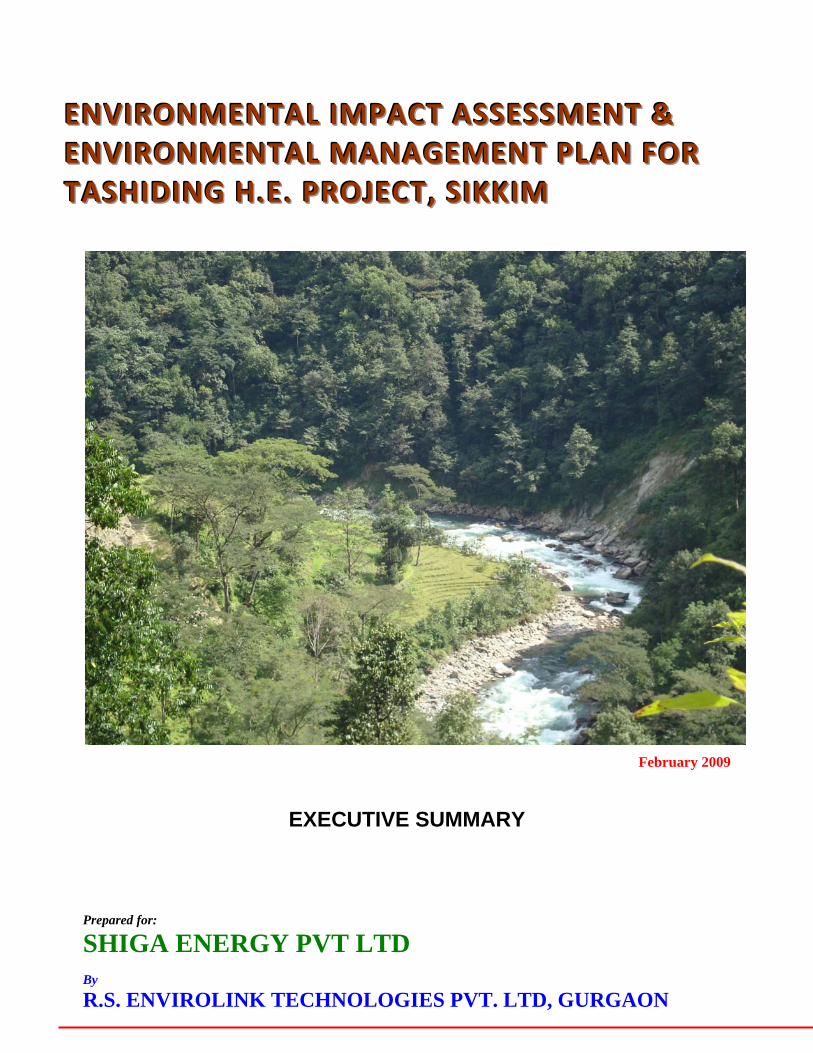
E E E N N N V V V I I I R R R O O O N N N M M M E E E N N N T T T A A A L L L I I I M M M P P P A A A C C C T T T A A A S S S S S S E E E S S S S S S M M M E E E N N N T T T & & & E E E N N N V V V I I I R R R O O O N N N M M M E E E N N N T T T A A A L L L M M M A A A N N N A A A G G G E E E M M M E E E N N N T T T P P P L L L A A A N N N F F F O O O R R R T T T A A A S S S H H H I I I D D D I I I N N N G G G H H H . . . E E E . . . P P P R R R O O O J J J E E E C C C T T T , , , S S S I I I K K K K K K I I I M M M EXECUTIVE SUMMARY Prepared for: SHIGA ENERGY PVT LTD By R.S. ENVIROLINK TECHNOLOGIES PVT. LTD, GURGAON February 2009
2.0 STUDY AREA AND FIELD SURVEYS 8 3.0 ENVIRONMENTAL BASELINE STATUS-PHYSICO-CHEMICAL ASPECTS 10
3.1 Physiography 10 3.2 Geological Setup of Project Area 13 3.3 Soil 16 3.4 Hydrology 17 3.5 Ambient Air, Noise and Traffic Density 20
4.0 ENVIRONMENTAL BASELINE STATUS - BIODIVERSITY ASPECTS 21
4.1 Land Use/ Land Cover 21 4.2 Forest Types 22 4.3 Vegetation Composition 23 4.4 Vegetation Composition In and around the Project Area 26 4.5 Community Structure 26 4.6 Conservation Status 27 4.7 Lower Plant Diversity 30 4.8 Faunal Elements 31 4.9 Herpetofauna 34 4.10 Aquatic Ecology 35 4.11 Fish and Fisheries 37
5.0 SOCIO-ECONOMIC ASPECTS 39 6.0 PREDICTION OF IMPACTS 39
6.1 Impacts on Land Environment 39 6.2 Impacts on Water Resources 41 6.3 Impacts on Water Quality 42 6.4 Impacts on Terrestrial Flora 43 6.5 Impacts on Terrestrial Fauna 43 6.6 Impacts on Aquatic Ecology 44 6.7 Impacts on Noise Environment 47 6.8 Air Pollution 47 6.9 Impacts on Socio-Economic Environment 48 6.10 Increased Incidence of Water-Related Diseases 49
Shiga Energy Pvt. Ltd. Executive Summary - Tashiding HEP
R S Envirolink Technologies Pvt. Ltd. Content
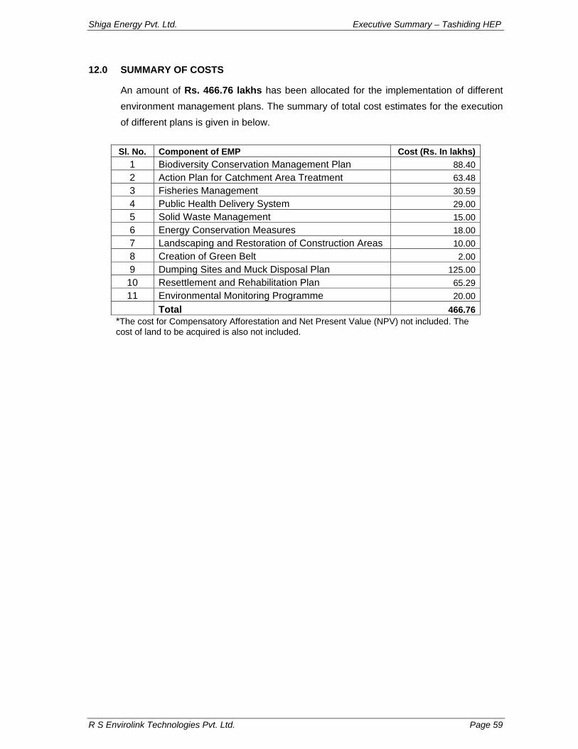
VOLUME II: ENVIRONMENT MANAGEMENT PLAN 1.0 BIODIVERSITY CONSERVATION & MANAGEMENT PLAN 50 2.0 CATCHMENT AREA TREATMENT PLAN 51 3.0 FISHERIES CONSERVATION PLAN 52 4.0 PUBLIC HEALTH DELIVERY SYSTEM 53 5.0 SOLID WASTE MANAGEMENT PLAN 53 6.0 FOREST PROTECTION PLAN 54 7.0 MUCK DISPOSAL PLAN 55 8.0 AIR & WATER ENVIRONMENT MANAGEMENT PLAN 56 9.0 COMPENSATORY AFFORESTATION PLAN 57 10.0 REHABILITATION & RESETTLEMENT PLAN 57 11.0 ENVIRONMENTAL MONITORING PROGRAMME 58 12.0 SUMMARY OF COSTS 59
VOLUME I
ENVIRONMENT IMPACT
ASSESSMENT
Shiga Energy Pvt. Ltd. Executive Summary – Tashiding HEP
R S Envirolink Technologies Pvt. Ltd. Page 1
1.0 PROJECT DESCRIPTION
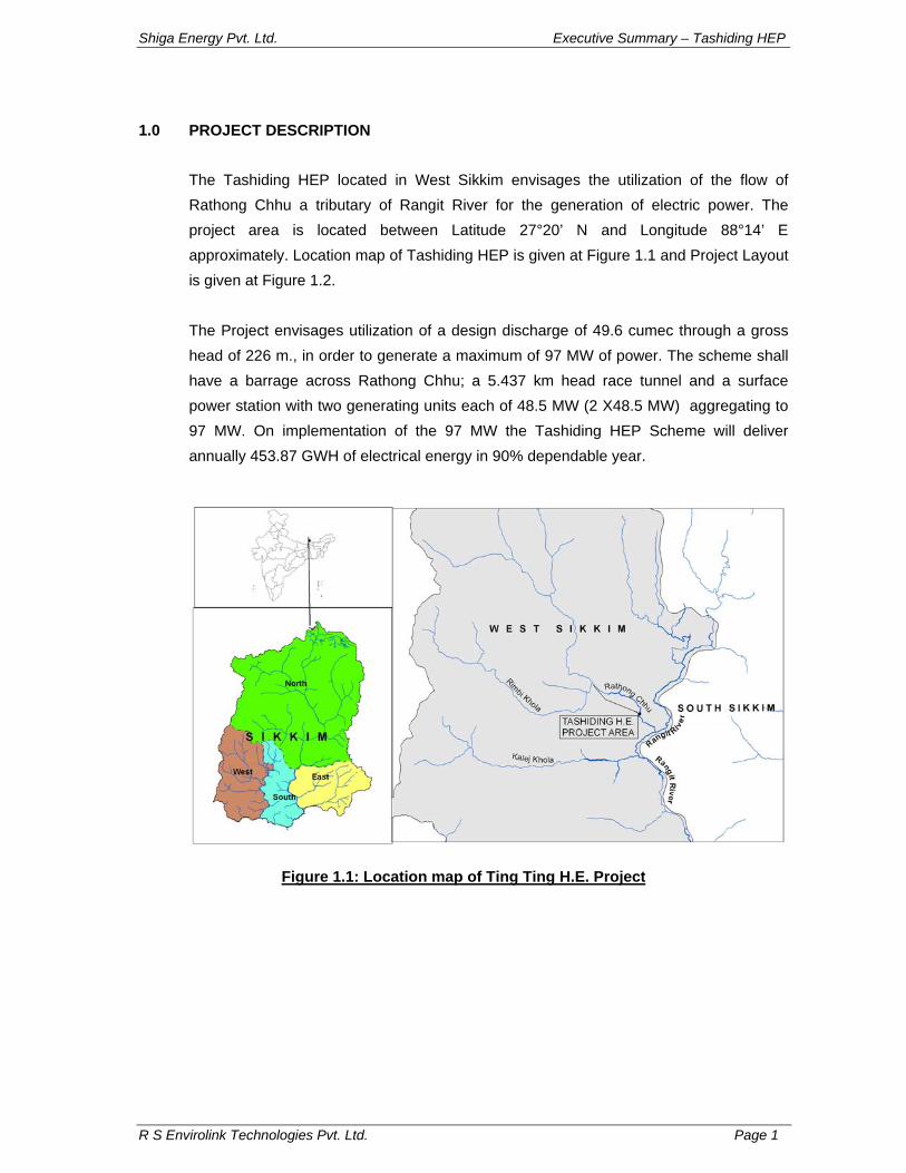
The Tashiding HEP located in West Sikkim envisages the utilization of the flow of Rathong Chhu a tributary of Rangit River for the generation of electric power. The project area is located between Latitude 27°20’ N and Longitude 88°14’ E approximately. Location map of Tashiding HEP is given at Figure 1.1 and Project Layout is given at Figure 1.2. The Project envisages utilization of a design discharge of 49.6 cumec through a gross head of 226 m., in order to generate a maximum of 97 MW of power. The scheme shall have a barrage across Rathong Chhu; a 5.437 km head race tunnel and a surface power station with two generating units each of 48.5 MW (2 X48.5 MW) aggregating to 97 MW. On implementation of the 97 MW the Tashiding HEP Scheme will deliver annually 453.87 GWH of electrical energy in 90% dependable year.
Figure 1.1: Location map of Ting Ting H.E. Project
Shiga Energy Pvt. Ltd. Executive Summary – Tashiding HEP
R S Envirolink Technologies Pvt. Ltd. Page 2
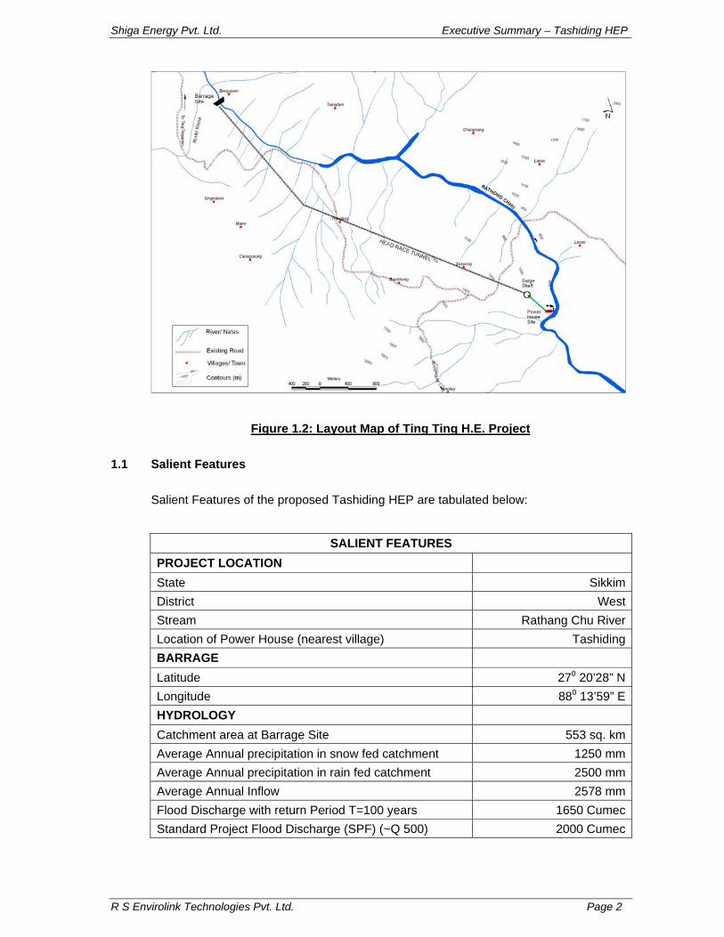
Figure 1.2: Layout Map of Ting Ting H.E. Project
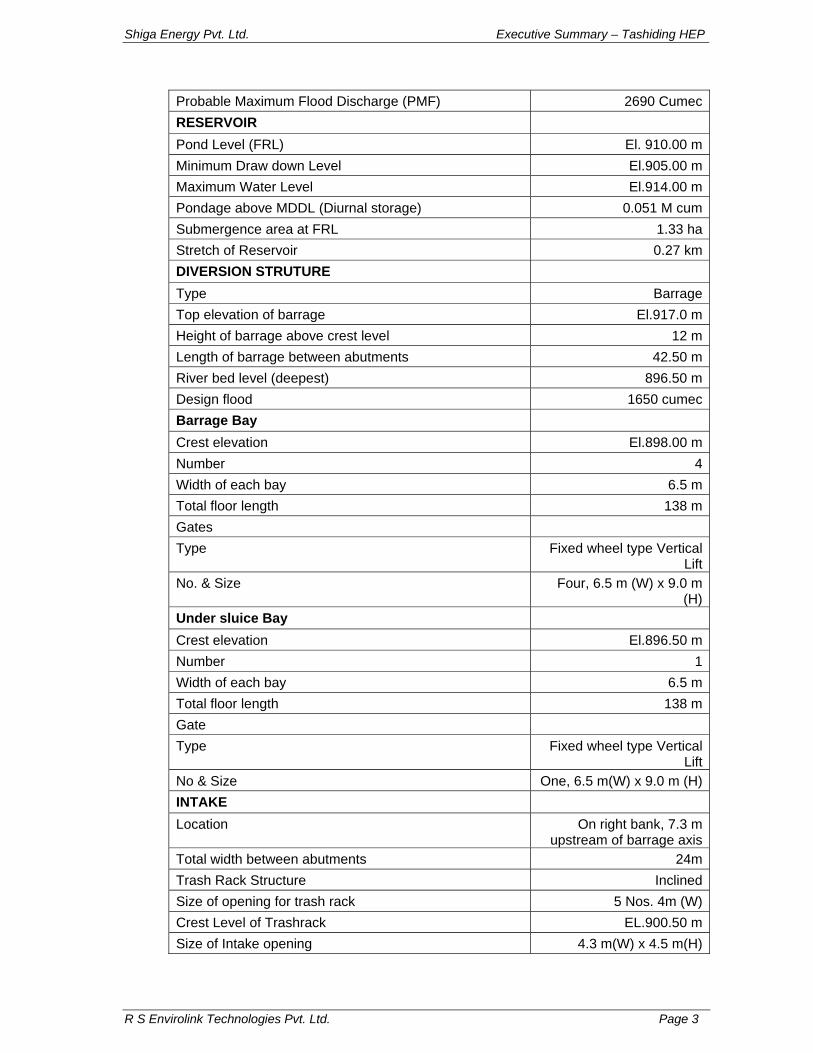
1.1 Salient Features
Salient Features of the proposed Tashiding HEP are tabulated below:
SALIENT FEATURES PROJECT LOCATION State Sikkim District West Stream Rathang Chu River Location of Power House (nearest village) Tashiding BARRAGE Latitude 270 20’28” N Longitude 880 13’59” E HYDROLOGY Catchment area at Barrage Site 553 sq. km Average Annual precipitation in snow fed catchment 1250 mm Average Annual precipitation in rain fed catchment 2500 mm Average Annual Inflow 2578 mm Flood Discharge with return Period T=100 years 1650 Cumec Standard Project Flood Discharge (SPF) (~Q 500) 2000 Cumec
Shiga Energy Pvt. Ltd. Executive Summary – Tashiding HEP
R S Envirolink Technologies Pvt. Ltd. Page 3
Probable Maximum Flood Discharge (PMF) 2690 Cumec RESERVOIR Pond Level (FRL) El. 910.00 m Minimum Draw down Level El.905.00 m Maximum Water Level El.914.00 m Pondage above MDDL (Diurnal storage) 0.051 M cum Submergence area at FRL 1.33 ha Stretch of Reservoir 0.27 km DIVERSION STRUTURE Type Barrage Top elevation of barrage El.917.0 m Height of barrage above crest level 12 m Length of barrage between abutments 42.50 m River bed level (deepest) 896.50 m Design flood 1650 cumec Barrage Bay Crest elevation El.898.00 m Number 4Width of each bay 6.5 m Total floor length 138 m Gates Type Fixed wheel type Vertical
Lift No. & Size Four, 6.5 m (W) x 9.0 m
(H) Under sluice Bay Crest elevation El.896.50 m Number 1Width of each bay 6.5 m Total floor length 138 m Gate Type Fixed wheel type Vertical
Lift No & Size One, 6.5 m(W) x 9.0 m (H) INTAKE Location On right bank, 7.3 m
upstream of barrage axis Total width between abutments 24m Trash Rack Structure Inclined Size of opening for trash rack 5 Nos. 4m (W) Crest Level of Trashrack EL.900.50 m Size of Intake opening 4.3 m(W) x 4.5 m(H)
Shiga Energy Pvt. Ltd. Executive Summary – Tashiding HEP
R S Envirolink Technologies Pvt. Ltd. Page 4
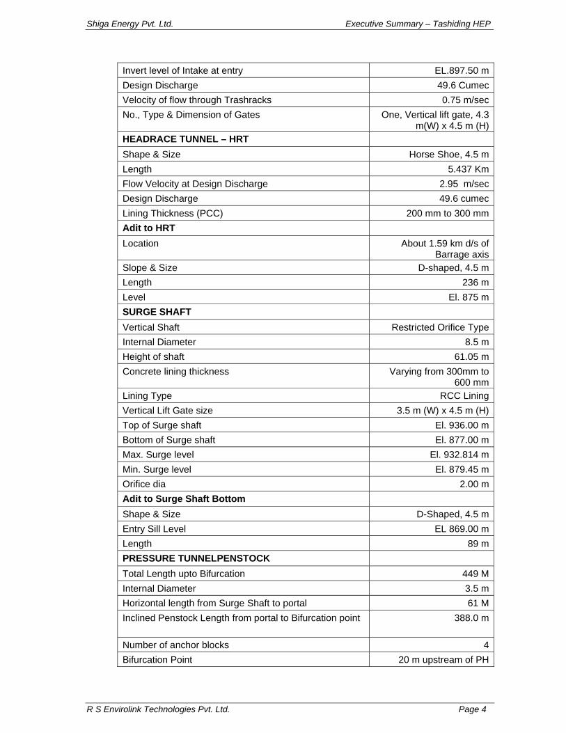
Invert level of Intake at entry EL.897.50 m Design Discharge 49.6 Cumec Velocity of flow through Trashracks 0.75 m/sec No., Type & Dimension of Gates One, Vertical lift gate, 4.3
m(W) x 4.5 m (H) HEADRACE TUNNEL – HRT Shape & Size Horse Shoe, 4.5 m Length 5.437 Km Flow Velocity at Design Discharge 2.95 m/secDesign Discharge 49.6 cumecLining Thickness (PCC) 200 mm to 300 mmAdit to HRT Location About 1.59 km d/s of
Barrage axisSlope & Size D-shaped, 4.5 mLength 236 mLevel El. 875 mSURGE SHAFT Vertical Shaft Restricted Orifice Type Internal Diameter 8.5 mHeight of shaft 61.05 mConcrete lining thickness Varying from 300mm to
600 mmLining Type RCC LiningVertical Lift Gate size 3.5 m (W) x 4.5 m (H)Top of Surge shaft El. 936.00 mBottom of Surge shaft El. 877.00 mMax. Surge level El. 932.814 mMin. Surge level El. 879.45 mOrifice dia 2.00 mAdit to Surge Shaft Bottom Shape & Size D-Shaped, 4.5 m Entry Sill Level EL 869.00 mLength 89 mPRESSURE TUNNELPENSTOCK Total Length upto Bifurcation 449 MInternal Diameter 3.5 m Horizontal length from Surge Shaft to portal 61 MInclined Penstock Length from portal to Bifurcation point 388.0 m
Number of anchor blocks 4Bifurcation Point 20 m upstream of PH
Shiga Energy Pvt. Ltd. Executive Summary – Tashiding HEP
R S Envirolink Technologies Pvt. Ltd. Page 5
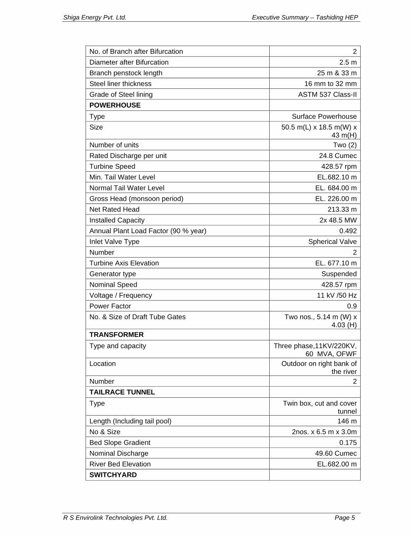
No. of Branch after Bifurcation 2Diameter after Bifurcation 2.5 m Branch penstock length 25 m & 33 m Steel liner thickness 16 mm to 32 mm Grade of Steel lining ASTM 537 Class-II POWERHOUSE Type Surface Powerhouse Size 50.5 m(L) x 18.5 m(W) x
43 m(H) Number of units Two (2) Rated Discharge per unit 24.8 Cumec Turbine Speed 428.57 rpm Min. Tail Water Level EL.682.10 m Normal Tail Water Level EL. 684.00 m Gross Head (monsoon period) EL. 226.00 m Net Rated Head 213.33 m Installed Capacity 2x 48.5 MW Annual Plant Load Factor (90 % year) 0.492Inlet Valve Type Spherical Valve Number 2Turbine Axis Elevation EL. 677.10 m Generator type Suspended Nominal Speed 428.57 rpm Voltage / Frequency 11 kV /50 Hz Power Factor 0.9No. & Size of Draft Tube Gates Two nos., 5.14 m (W) x
4.03 (H) TRANSFORMER Type and capacity Three phase,11KV/220KV,
60 MVA, OFWFLocation Outdoor on right bank of
the river Number 2TAILRACE TUNNEL Type Twin box, cut and cover
tunnel Length (Including tail pool) 146 mNo & Size 2nos. x 6.5 m x 3.0m Bed Slope Gradient 0.175Nominal Discharge 49.60 CumecRiver Bed Elevation EL.682.00 mSWITCHYARD
Shiga Energy Pvt. Ltd. Executive Summary – Tashiding HEP
R S Envirolink Technologies Pvt. Ltd. Page 6
Type OutdoorLocation of Switchyard Upstream of PH on right
bank at El. 705 and 710 mBus bar Voltage 220 KVTRANSMISSION LINE Switch yard to Meli
pooling station Type Single Circuit 2 x 220 KVLength About 27 KmCONSTRUCTION PERIOD Construction Period in months (excluding pre-construction works)
33 months
1.2 Infrastructure Following infrastructure facilities will be required for construction of the Project • Access roads in the Project area to various work sites, camps, offices, muck
disposal area, job facility sites etc. • Bridges and cross-drainage works. • Residential buildings for the Project staff & offices including their electricity &
provision of water supply, sanitation & drainage works. • Non-residential buildings • Telecommunication net work • Construction Power Access Roads The Tashiding Diversion site is located on Rathang Chu river about 140 m d/s of its confluence with Rimbi Khola on the Melli-Pelling-Yuksum State Highway and the Power house is about 10 Km further downstream. The state highway from Pelling after crossing the Rimbi Khola runs along the right bank. The requirement of access roads to the work sites from the existing state highway shall be as under. i) Diversion Structure
The proposed Tashiding diversion structure site is approachable from the same Pelling – Yuksum SPWD road, which is located at an elevation of El.1160 m (approx.) near Rimbi Khola confluence. Approach road for diversion structure site is possible from the left bank of Rimbi Khola close to its confluence with Rathang Chu from the existing road to Yuksum. An Iron bridge is existing at El.930 m u/s of the confluence of Rathang Chu river & Rimbi Khola. This will be replaced with a permanent bridge for approach to the left bank of Rathang Chu u/s of diversion site.
Shiga Energy Pvt. Ltd. Executive Summary – Tashiding HEP
R S Envirolink Technologies Pvt. Ltd. Page 7
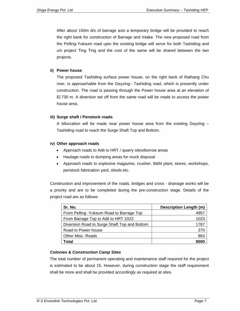
After about 150m d/s of barrage axis a temporary bridge will be provided to reach the right bank for construction of Barrage and Intake. The new proposed road from the Pelling-Yuksum road upto the existing bridge will serve for both Tashiding and u/s project Ting Ting and the cost of the same will be shared between the two projects.
ii) Power house The proposed Tashiding surface power house, on the right bank of Rathang Chu river, is approachable from the Geyzing– Tashiding road, which is presently under construction. The road is passing through the Power house area at an elevation of El.730 m. A diversion set off from the same road will be made to access the power house area.
iii) Surge shaft / Penstock roads A bifurcation will be made near power house area from the existing Geyzing –Tashiding road to reach the Surge Shaft Top and Bottom.
iv) Other approach roads
• Approach roads to Adit to HRT / quarry sites/borrow areas • Haulage roads to dumping areas for muck disposal • Approach roads to explosive magazine, crusher, B&M plant, stores, workshops,
penstock fabrication yard, sheds etc. Construction and improvement of the roads, bridges and cross - drainage works will be a priority and are to be completed during the pre-construction stage. Details of the project road are as follows:
Sr. No. Description Length (m)From Pelling -Yuksum Road to Barrage Top 4957From Barrage Top to Adit to HRT 1023 1023Diversion Road to Surge Shaft Top and Bottom 1787Road to Power house 370Other Misc. Roads 863Total 9000
Colonies & Construction Camp Sites The total number of permanent operating and maintenance staff required for the project is estimated to be about 15. However, during construction stage the staff requirement shall be more and shall be provided accordingly as required at sites.
Shiga Energy Pvt. Ltd. Executive Summary – Tashiding HEP
R S Envirolink Technologies Pvt. Ltd. Page 8
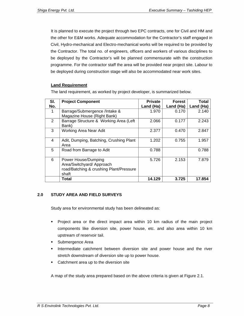
It is planned to execute the project through two EPC contracts, one for Civil and HM and the other for E&M works. Adequate accommodation for the Contractor’s staff engaged in Civil, Hydro-mechanical and Electro-mechanical works will be required to be provided by the Contractor. The total no. of engineers, officers and workers of various disciplines to be deployed by the Contractor’s will be planned commensurate with the construction programme. For the contractor staff the area will be provided near project site. Labour to be deployed during construction stage will also be accommodated near work sites. Land Requirement The land requirement, as worked by project developer, is summarized below.
Sl. No.
Project Component Private Land (Ha)
Forest Land (Ha)
Total Land (Ha)
1 Barrage/Submergence /Intake & Magazine House (Right Bank)
1.970 0.170 2.140
2 Barrage Structure & Working Area (Left Bank)
2.066 0.177 2.243
3 Working Area Near Adit
2.377 0.470 2.847
4 Adit, Dumping, Batching, Crushing Plant Area
1.202 0.755 1.957
5 Road from Barrage to Adit
0.788 0.788
6 Power House/Dumping Area/Switchyard/ Approach road/Batching & crushing Plant/Pressure shaft
5.726 2.153 7.879
Total 14.129 3.725 17.854
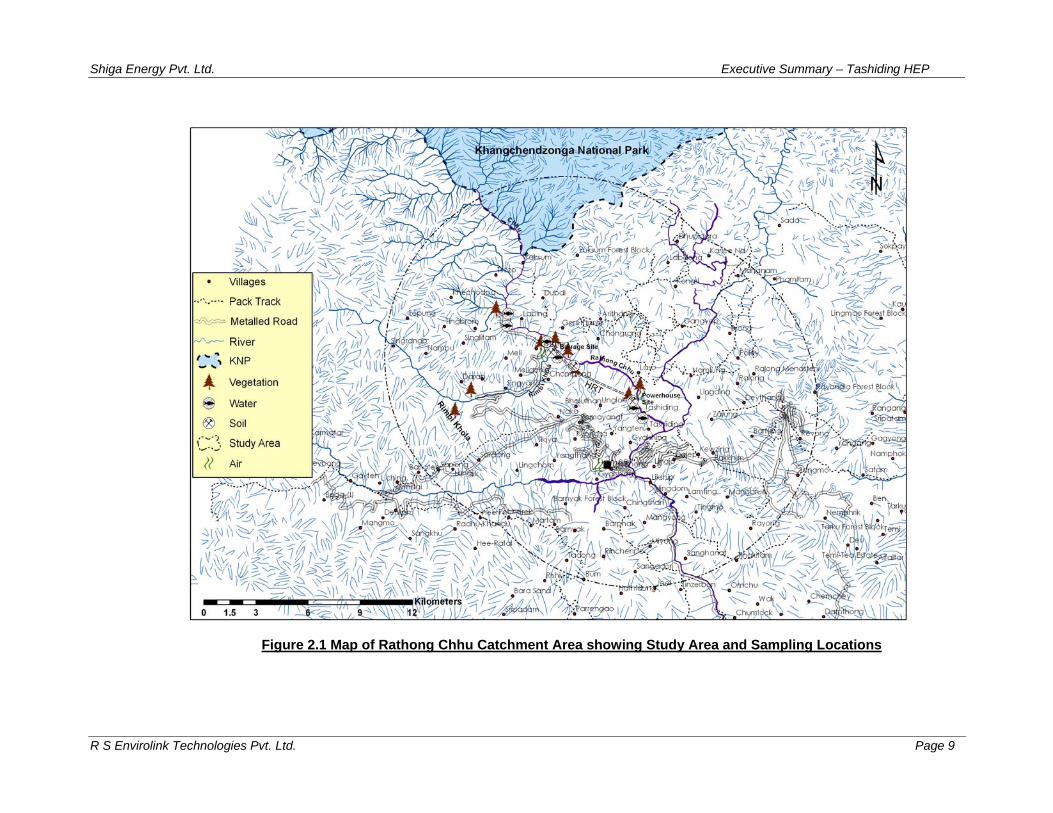
2.0 STUDY AREA AND FIELD SURVEYS
Study area for environmental study has been delineated as: Project area or the direct impact area within 10 km radius of the main project
components like diversion site, power house, etc. and also area within 10 km upstream of reservoir tail.
Submergence Area Intermediate catchment between diversion site and power house and the river
stretch downstream of diversion site up to power house. Catchment area up to the diversion site
A map of the study area prepared based on the above criteria is given at Figure 2.1.
Shiga Energy Pvt. Ltd. Executive Summary – Tashiding HEP
R S Envirolink Technologies Pvt. Ltd. Page 9
Figure 2.1 Map of Rathong Chhu Catchment Area showing Study Area and Sampling Locations
Shiga Energy Pvt. Ltd. Executive Summary – Tashiding HEP
R S Envirolink Technologies Pvt. Ltd. Page 10
The field surveys commenced from January 2008 and were conducted in different seasons of the year i.e. winter, monsoon and post monsoon to collect data/ information on flora, fauna, forest types and ecological parameters as well as sociological aspects. In addition, surveys and studies were also conducted for understanding aquatic ecology and fish diversity of Rathang Chhu. Following seasons have been covered for collection of baseline data in the study area (Table 2.1). Field surveys in the study area were also conducted for the purpose of ground truthing and augmenting the remote sensing data. For this purpose various attributes such as land features, rivers, forest and vegetation types were recorded on the ground.
Table 2.1: Sampling Frequency for Various Environmental Parameters
3.0 ENVIRONMENTAL BASELINE STATUS - PHYSICO-CHEMICAL ASPECTS 3.1 Physiography
Sikkim state being a part of inner mountain ranges of Himalaya is mostly hilly. The altitude above mean sea level varies from 230 m in the south to above 8,500 m in the north and the hill slope generally ranges between 4% in the flat valleys to 90% and characterised by undertaking surface features. The habitable areas exist only up to the altitude of 2,100 m constituting only 20% of the total area of the state. The hill tops are in the North, East and West and covered with perpetual snow which feed the two major rivers, the Teesta and the Rangit traversing through the state from North to South. The highest portion of Sikkim lies in its North-West direction, which includes Khangchendzonga, the third highest peak in the world at an elevation of 8,598 m. A number of glaciers descend from the eastern slopes of Khangchendzonga where snow line is found above 5,300 m. The biggest amongst them is Zemu glacier.
The geographical area of the proposed Tashiding hydroelectric project site falls in West Sikkim district. The West district with an area of 1,166 sq km has a rectangular shape
Shiga Energy Pvt. Ltd. Executive Summary – Tashiding HEP
R S Envirolink Technologies Pvt. Ltd. Page 11
with North-South elongation. The elevation varies from 350 m at Jorethang in the south to 7,000 m near Pandim in the north. The district has only one glaciated basin known as the East Rathong basin located west of Teesta River. This basin has a total of 36 glaciers of different sizes covering an area of 57.8 sq km.
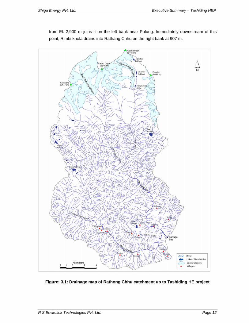
. The catchment area map of Tashiding HE project is shown in Figure 3.1.
Rathong Chhu is the major tributary of Rangit river in West Sikkim and originates at an
elevation of 4900 m from Rathong Glacier. Rathong Chhu is formed by the confluence of
two streams i.e. Prek Chhu and Chokchurang Chhu (see Figure 3.1). Prek Chhu stream
originates from Onglakthang glacier (4,200m). It receives water from number of glacial
lakes like Tikuchia Pokhari (4,800 m), Chamliya Pokhari (4,600 m) and Sungmoteng
Chho (4,280 m) whichlocated on the lateral moraines on the left flank of Onglakthang
glacier. Prek Chhu flows for about 12km up to an El. 3840 m where it receives water from
a stream named Kokchhurong, which is fed by glacier at the base of Forked Peak (6,220
m). From this confluence Prek Chhu flows for another 10 km up to El. 2,175 m where
Chokchurang Chhu drains into it on the right bank.
Chokchurang Chhu originates from East Rathong glacier at 4,600 m from where it flows for about 7 km up to El. 3,780 m where Rungli Chhu (> 4,000 m) joins it on the right bank. From here the stream flows 1km up to 3,770 m and receives water from Tikip Chhu on its right bank. After this it flows for another 2.3 km and receives water from Koklung Chhu on its right bank which traverses a distance of about 7 km from its origin at 5,000 m. Downstream of this confluence the river flows 1.7 km where Gomathang Chhu joins it on the right bank at 3140 m. Gomathang Chhu has its headwaters in a glacial lake complex. Mujur Pokhari (4,260 m), Simana Pokhari (4,540 m), Lachhmi Pokhari (4,320 m) and Thumlo Jumle Pokhari (4,400 m) are some of the glacial lakes in this region that contribute significantly to the discharge of Gomathang Chhu. Gomathang Chhu after receiving water from Dhop Chhu on the right bank drains into Chokchurang Chhu on its right bank at 3,140 m. After flowing for about 4.5 km from this confluence Chokchurang Chhu receives water from Baliajhore Chhu (4,300 m) on its right bank at 2340 m and then flows for another 1.2 km to join Prek Chhu on its right bank at 2,175 m. After their confluence it is known as Rathang Chhu. Rathang Chhu then traverses a distance of 1.7 km up to 1,970 m and receives water from Pongmirang Chhu on its right bank. Thereafter it flows down about 9 km up to the proposed Tashiding barrage site.
Phamrong Chhu and Rimbi Khola are two significant tributaries immediately upstream of the barrage site in the project study area (Figure 3.1). Phamrang Chhu flowing 7.5 km
Shiga Energy Pvt. Ltd. Executive Summary – Tashiding HEP
R S Envirolink Technologies Pvt. Ltd. Page 12
from El. 2,900 m joins it on the left bank near Pulung. Immediately downstream of this point, Rimbi khola drains into Rathang Chhu on the right bank at 907 m.
Figure: 3.1: Drainage map of Rathong Chhu catchment up to Tashiding HE project
Shiga Energy Pvt. Ltd. Executive Summary – Tashiding HEP
R S Envirolink Technologies Pvt. Ltd. Page 13
Rimbi Khola a major tributary of Rathong Chhu and originates from Lachhmi Pokhari and Lam Pokhari lakes as Chhinjyum Khola and drains the forested areas through Pale Khola on its left bank and Longman Khola on its right bank. From this point, the stream flows as Rimbi Khola and receives water from a number of streams like Thar Khola, Heri Khola near village Rimbi, Nambu Khola and Lingsur Khola on either side. After this confluence, it flows as Rathong Chhu. Rathong Chhu then joins Rangit River on its right bank at 602 m. From this confluence Rangit river is fed by Kalej Khola on the right bank. Rimbi Khola joins the Rathong Chhu about 150 m downstream of the proposed powerhouse site of the project.
3.2 Geological Setup of Project Area
The project is located northwest of the Rangit Window. La Touche (1900) was probably the first to report the presence of sedimentary rocks in Rangit valley in otherwise predominantly known as metamorphic domain. Ghosh (ibid) was first to postulate a window structure, which crops out in the re-entrant of Rangit River. Major tectonic surfaces in the Sikkim Himalaya wrap round this re-entrant. The sedimentaries in the Rangit window belong to Precambrian Daling and Buxa with overlying Permian Gondwanas which have been terminated by the Tendong Thrust (MCT-III) which has brought the Daling rocks in juxtaposition with Gondwanas. The Daling meta-sedimentaries displaying low grade metamorphism are exposed in a wide zone along the Rangit valley but in the Rathang Chhu Valley these rocks have been terminated by the Main Central Thrust (MCT-II) which has brought higher grade metamorphic rocks of Darjeeling Group in juxta position with the Daling rocks. The trace of this tectonic surface passes very near to Peling, cuts across the Rathang Chu downstream of the proposed power house of the Tashiding project and rises on the left bank slopes to cross the Tashiding - Yuksam road. The Darjeeling Group of rocks are higher grade gneisses belonging to the Central Crystalline Gneissic Complex (CCGC) having intra-bands of meta-sedimentaries represented by cafe silicate / quartzite, high grade schists which in some areas are mapped as Chungthang Formation and at other places it then occur as enclaves in the high grade gneisses. The gneisses vary in composition from gneiss in which feldspar is predominant with respect to quartz, to quartz biotite gneiss in which feldspar is almost absent. The former type is well foliated with streaks of biotite and the latter is compact and poorly foliated.
Shiga Energy Pvt. Ltd. Executive Summary – Tashiding HEP
R S Envirolink Technologies Pvt. Ltd. Page 14
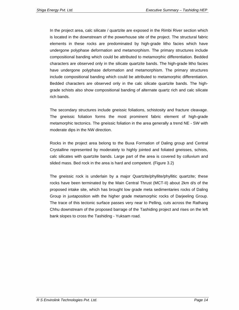
In the project area, calc silicate / quartzite are exposed in the Rimbi River section which is located in the downstream of the powerhouse site of the project. The structural fabric elements in these rocks are predominated by high-grade litho facies which have undergone polyphase deformation and metamorphism. The primary structures include compositional banding which could be attributed to metamorphic differentiation. Bedded characters are observed only in the silicate quartzite bands. The high-grade litho facies have undergone polyphase deformation and metamorphism. The primary structures include compositional banding which could be attributed to metamorphic differentiation. Bedded characters are observed only in the calc silicate quartzite bands. The high-grade schists also show compositional banding of alternate quartz rich and calc silicate rich bands. The secondary structures include gneissic foliations, schistosity and fracture cleavage. The gneissic foliation forms the most prominent fabric element of high-grade metamorphic tectonics. The gneissic foliation in the area generally a trend NE - SW with moderate dips in the NW direction. Rocks in the project area belong to the Buxa Formation of Daling group and Central Crystalline represented by moderately to highly jointed and foliated gneisses, schists, calc silicates with quartzite bands. Large part of the area is covered by colluvium and slided mass. Bed rock in the area is hard and competent. (Figure 3.2) The gneissic rock is underlain by a major Quartzite/phyllite/phyllitic quartzite; these rocks have been terminated by the Main Central Thrust (MCT-II) about 2km d/s of the proposed intake site, which has brought low grade meta sedimentaries rocks of Daling Group in juxtaposition with the higher grade metamorphic rocks of Darjeeling Group. The trace of this tectonic surface passes very near to Pelling, cuts across the Rathang Chhu downstream of the proposed barrage of the Tashiding project and rises on the left bank slopes to cross the Tashiding - Yuksam road.
Shiga Energy Pvt. Ltd. Executive Summary – Tashiding HEP
R S Envirolink Technologies Pvt. Ltd. Page 15
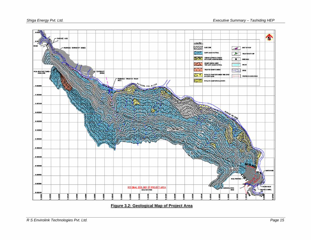
Figure 3.2: Geological Map of Project Area
Shiga Energy Pvt. Ltd. Executive Summary – Tashiding HEP
R S Envirolink Technologies Pvt. Ltd. Page 16
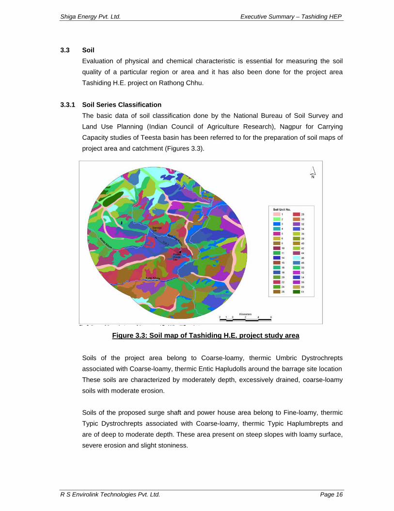
3.3 Soil Evaluation of physical and chemical characteristic is essential for measuring the soil quality of a particular region or area and it has also been done for the project area Tashiding H.E. project on Rathong Chhu.
3.3.1 Soil Series Classification
The basic data of soil classification done by the National Bureau of Soil Survey and Land Use Planning (Indian Council of Agriculture Research), Nagpur for Carrying Capacity studies of Teesta basin has been referred to for the preparation of soil maps of project area and catchment (Figures 3.3).
Soils of the project area belong to Coarse-loamy, thermic Umbric Dystrochrepts associated with Coarse-loamy, thermic Entic Hapludolls around the barrage site location These soils are characterized by moderately depth, excessively drained, coarse-loamy soils with moderate erosion. Soils of the proposed surge shaft and power house area belong to Fine-loamy, thermic Typic Dystrochrepts associated with Coarse-loamy, thermic Typic Haplumbrepts and are of deep to moderate depth. These area present on steep slopes with loamy surface, severe erosion and slight stoniness.
Figure 3.3: Soil map of Tashiding H.E. project study area
Shiga Energy Pvt. Ltd. Executive Summary – Tashiding HEP
R S Envirolink Technologies Pvt. Ltd. Page 17
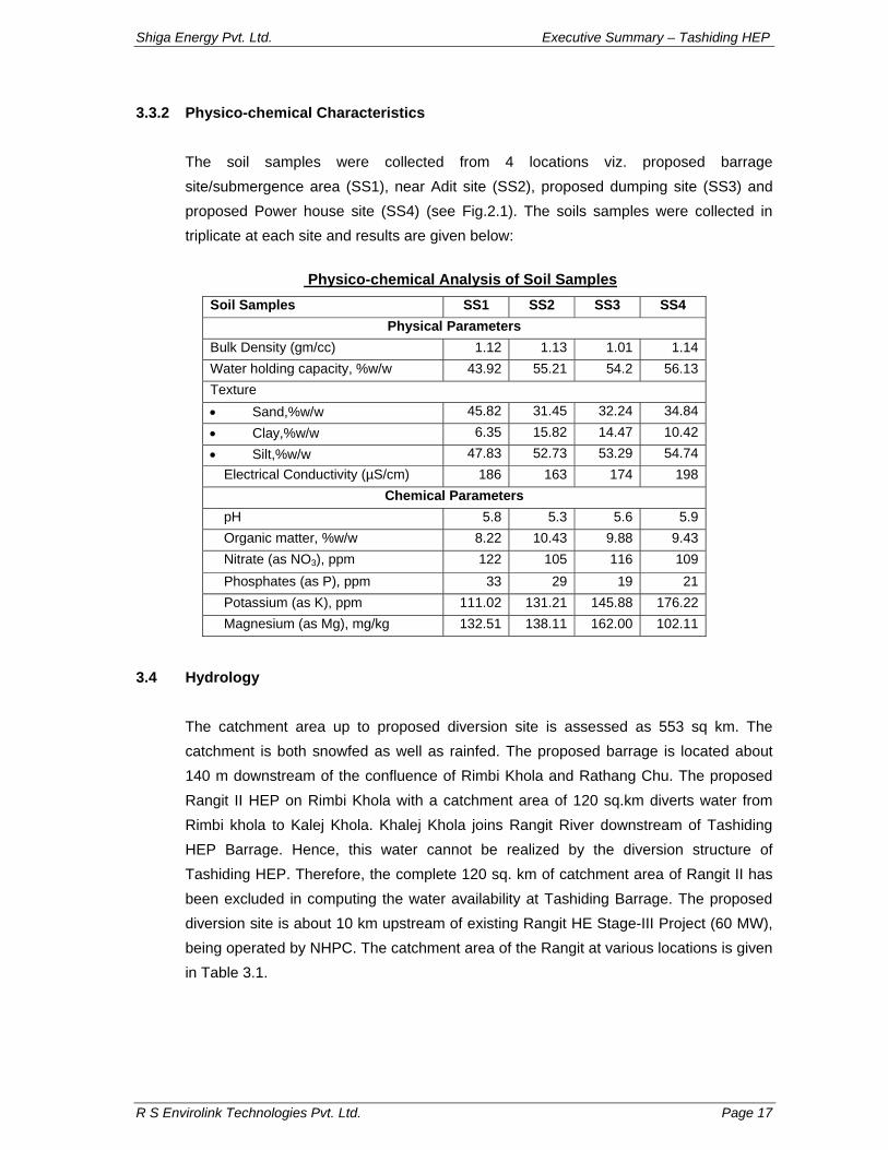
3.3.2 Physico-chemical Characteristics The soil samples were collected from 4 locations viz. proposed barrage site/submergence area (SS1), near Adit site (SS2), proposed dumping site (SS3) and proposed Power house site (SS4) (see Fig.2.1). The soils samples were collected in triplicate at each site and results are given below:
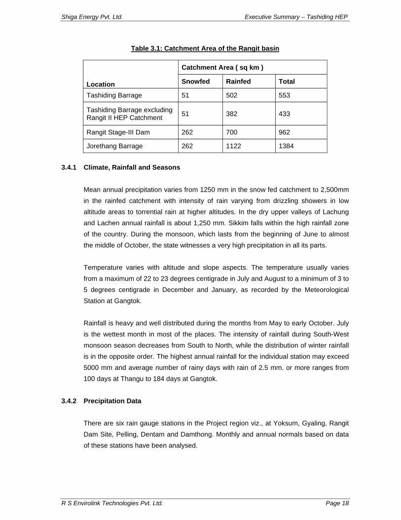
3.4 Hydrology The catchment area up to proposed diversion site is assessed as 553 sq km. The catchment is both snowfed as well as rainfed. The proposed barrage is located about 140 m downstream of the confluence of Rimbi Khola and Rathang Chu. The proposed Rangit II HEP on Rimbi Khola with a catchment area of 120 sq.km diverts water from Rimbi khola to Kalej Khola. Khalej Khola joins Rangit River downstream of Tashiding HEP Barrage. Hence, this water cannot be realized by the diversion structure of Tashiding HEP. Therefore, the complete 120 sq. km of catchment area of Rangit II has been excluded in computing the water availability at Tashiding Barrage. The proposed diversion site is about 10 km upstream of existing Rangit HE Stage-III Project (60 MW), being operated by NHPC. The catchment area of the Rangit at various locations is given in Table 3.1.
Shiga Energy Pvt. Ltd. Executive Summary – Tashiding HEP
R S Envirolink Technologies Pvt. Ltd. Page 18
Table 3.1: Catchment Area of the Rangit basin
Location
Catchment Area ( sq km )
Snowfed Rainfed Total
Tashiding Barrage 51 502 553
Tashiding Barrage excluding Rangit II HEP Catchment 51 382 433
Rangit Stage-III Dam 262 700 962
Jorethang Barrage 262 1122 1384
3.4.1 Climate, Rainfall and Seasons
Mean annual precipitation varies from 1250 mm in the snow fed catchment to 2,500mm in the rainfed catchment with intensity of rain varying from drizzling showers in low altitude areas to torrential rain at higher altitudes. In the dry upper valleys of Lachung and Lachen annual rainfall is about 1,250 mm. Sikkim falls within the high rainfall zone of the country. During the monsoon, which lasts from the beginning of June to almost the middle of October, the state witnesses a very high precipitation in all its parts. Temperature varies with altitude and slope aspects. The temperature usually varies from a maximum of 22 to 23 degrees centigrade in July and August to a minimum of 3 to 5 degrees centigrade in December and January, as recorded by the Meteorological Station at Gangtok. Rainfall is heavy and well distributed during the months from May to early October. July is the wettest month in most of the places. The intensity of rainfall during South-West monsoon season decreases from South to North, while the distribution of winter rainfall is in the opposite order. The highest annual rainfall for the individual station may exceed 5000 mm and average number of rainy days with rain of 2.5 mm. or more ranges from 100 days at Thangu to 184 days at Gangtok.
3.4.2 Precipitation Data
There are six rain gauge stations in the Project region viz., at Yoksum, Gyaling, Rangit Dam Site, Pelling, Dentam and Damthong. Monthly and annual normals based on data of these stations have been analysed.
Shiga Energy Pvt. Ltd. Executive Summary – Tashiding HEP
R S Envirolink Technologies Pvt. Ltd. Page 19
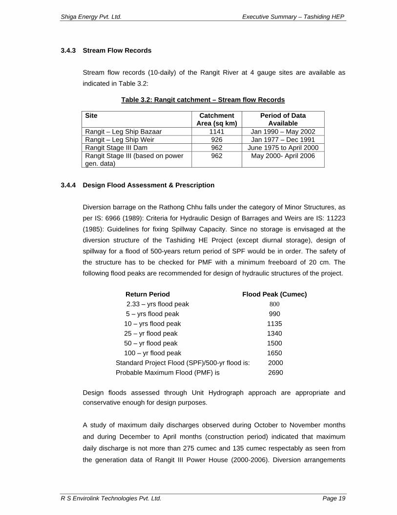
3.4.3 Stream Flow Records
Stream flow records (10-daily) of the Rangit River at 4 gauge sites are available as indicated in Table 3.2:
Table 3.2: Rangit catchment – Stream flow Records
Site Catchment
Area (sq km) Period of Data
Available Rangit – Leg Ship Bazaar 1141 Jan 1990 – May 2002 Rangit – Leg Ship Weir 926 Jan 1977 – Dec 1991 Rangit Stage III Dam 962 June 1975 to April 2000 Rangit Stage III (based on power gen. data)
962 May 2000- April 2006
3.4.4 Design Flood Assessment & Prescription
Diversion barrage on the Rathong Chhu falls under the category of Minor Structures, as per IS: 6966 (1989): Criteria for Hydraulic Design of Barrages and Weirs are IS: 11223 (1985): Guidelines for fixing Spillway Capacity. Since no storage is envisaged at the diversion structure of the Tashiding HE Project (except diurnal storage), design of spillway for a flood of 500-years return period of SPF would be in order. The safety of the structure has to be checked for PMF with a minimum freeboard of 20 cm. The following flood peaks are recommended for design of hydraulic structures of the project.
10 – yrs flood peak 1135 25 – yr flood peak 1340 50 – yr flood peak 1500 100 – yr flood peak 1650
Standard Project Flood (SPF)/500-yr flood is: 2000 Probable Maximum Flood (PMF) is 2690
Design floods assessed through Unit Hydrograph approach are appropriate and conservative enough for design purposes.
A study of maximum daily discharges observed during October to November months
and during December to April months (construction period) indicated that maximum
daily discharge is not more than 275 cumec and 135 cumec respectably as seen from
the generation data of Rangit III Power House (2000-2006). Diversion arrangements
Shiga Energy Pvt. Ltd. Executive Summary – Tashiding HEP
R S Envirolink Technologies Pvt. Ltd. Page 20
during construction at Tashiding Barrage site may be made to cater for a discharge of at
least 175 cumec on a proportionate catchment assessment.
3.5 Ambient Air, Noise and Traffic Density 3.5.1 Ambient Air Quality The proposed Tashiding HE project on Rathong Chhu does not come in the category of
air polluting projects. The air environment of the region is also very clean. The project is
in Gyalzing sub-division of West Sikkim. There is no major industry in the district. Traffic
is also very low in the district. The Tashiding Diversion site is located on Rathang Chu
river about 140 m d/s of its confluence with Rimbi Khola on the Melli-Pelling-Yuksum
State Highway and the Power house is about 10 Km further downstream. The state
highway from Pelling after crossing the Rimbi Khola runs along the right bank. Only light
vehicles and army trucks ply on this route. Main source of air pollution in the region
could be kitchen fuel, which is mainly wood. The region is totally covered with forest
(82% of Sikkim is covered with forest), so the chances for air pollution from agricultural
fields and open area is also very low. The levels of SPM, RPM, NOx and SO2 were
assessed using High Volume Air Sampler (APM 460 BL). Ambient Air Quality monitoring
was carried out at three different locations
3.5.2 Noise Levels
Noise monitoring is carried out at various sampling location along the river and near
villages. The sampling location includes submergence area, barrage site, power house
site and downstream of the powerhouse site. The project area is almost silent mostly the
noise is from river, water falls and local vehicles (generally jeeps). The noise level varied
from 62.41 to 74.4 dBA along the river whereas near villages, it ranged from 37.1 to
55.7 dBA
3.5.3 Traffic Density
Major towns around the project area of Tashiding H.E. Project are Gyalzing and
Yuksam. Gyalzing-Yuksam is the main traffic routes in the region. The traffic is
seasonal, peak traffic is observed during May-October, when tourists visit various places
like Pelling and Yoksum. During tourist season, different types of vehicles ply on this
road. During off-season (with respect to tourist flow) only local vehicles and few small
trucks ply in the region. Buses are also few and they ply in the morning and evening
hours only. In Sikkim light vehicles are the main transport mode on the roads. Under
Shiga Energy Pvt. Ltd. Executive Summary – Tashiding HEP
R S Envirolink Technologies Pvt. Ltd. Page 21
heavy vehicle category buses are very few. Though all types of vehicles were observed,
however majority were of small vehicles like Marshal, Jeeps and Maruti vans. The traffic
data was taken near villages along the study area of proposed project.
4.0 ENVIRONMENTAL BASELINE STATUS - BIODIVERSITY ASPECTS
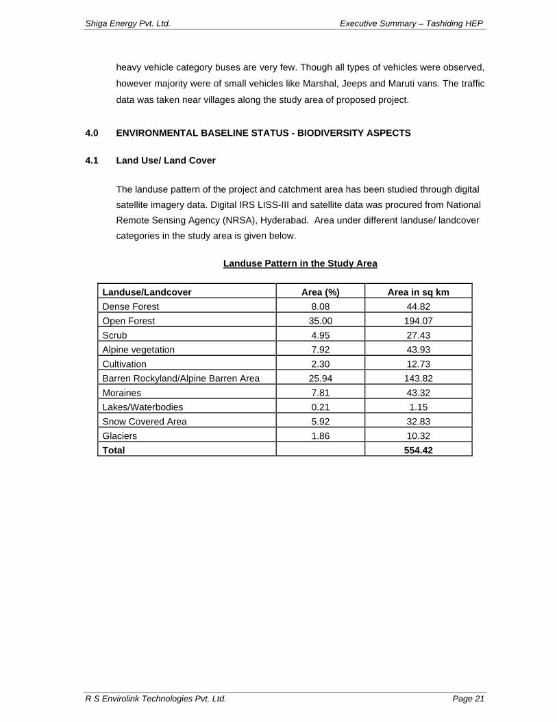
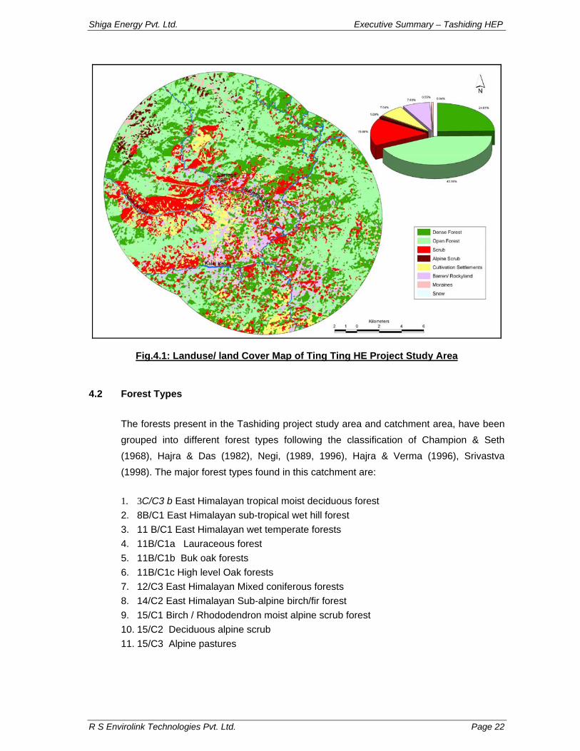
4.1 Land Use/ Land Cover The landuse pattern of the project and catchment area has been studied through digital satellite imagery data. Digital IRS LISS-III and satellite data was procured from National Remote Sensing Agency (NRSA), Hyderabad. Area under different landuse/ landcover categories in the study area is given below.
Landuse Pattern in the Study Area
Landuse/Landcover Area (%) Area in sq km Dense Forest 8.08 44.82 Open Forest 35.00 194.07 Scrub 4.95 27.43 Alpine vegetation 7.92 43.93 Cultivation 2.30 12.73 Barren Rockyland/Alpine Barren Area 25.94 143.82 Moraines 7.81 43.32 Lakes/Waterbodies 0.21 1.15 Snow Covered Area 5.92 32.83 Glaciers 1.86 10.32 Total 554.42
Shiga Energy Pvt. Ltd. Executive Summary – Tashiding HEP
R S Envirolink Technologies Pvt. Ltd. Page 22
Fig.4.1: Landuse/ land Cover Map of Ting Ting HE Project Study Area
4.2 Forest Types
The forests present in the Tashiding project study area and catchment area, have been grouped into different forest types following the classification of Champion & Seth (1968), Hajra & Das (1982), Negi, (1989, 1996), Hajra & Verma (1996), Srivastva (1998). The major forest types found in this catchment are:
1. 3C/C3 b East Himalayan tropical moist deciduous forest 2. 8B/C1 East Himalayan sub-tropical wet hill forest 3. 11 B/C1 East Himalayan wet temperate forests 4. 11B/C1a Lauraceous forest 5. 11B/C1b Buk oak forests 6. 11B/C1c High level Oak forests 7. 12/C3 East Himalayan Mixed coniferous forests 8. 14/C2 East Himalayan Sub-alpine birch/fir forest 9. 15/C1 Birch / Rhododendron moist alpine scrub forest 10. 15/C2 Deciduous alpine scrub 11. 15/C3 Alpine pastures
Shiga Energy Pvt. Ltd. Executive Summary – Tashiding HEP
Tashiding H.E. project area extends from Legship village near the confluence of Rathong Chhu with Rangit river up to Yuksum village and touches the Buffer zone-IV of Khangchendzonga Biosphere Reserve in the catchment of Rathong Chhu. In all 457 species of angiosperms and gymnosperms were recorded from Tashiding study area. Out of estimated 17,500 flowering plant species in India and nearly 4,500 species of flowering plants in Sikkim Himalaya (Mudgal & Hajra, 1997; Singh & Chauhan, 1999), about 450 species of angiosperms were recorded from Tashiding H.E. project study area in the region between confluence of Rathong Chhu with Rangit river and Rimbi Khola confluence with Rathong Chhu to Yoksum and Yoksum to Tsoka (along Rathong Chhu and Prek Chhu) in West Sikkim. In all 110 flowering plant families are represented in this area of which 95 are dicots, 15 are monocots. The dicotyledons are represented by 315 species belonging to 231 genera and 95 families, while the monocotyledons are represented by 15 families, 84 genera and 135 species. Gymnosperms are represented by 3 families, 4 genera and 5 species. The ratio of monocot to dicot species is 1:2.33 (135 monocots and 315 dicots). For monocots, family to genera, family to species and genera to species ratios are 1: 5.6, 1: 9.0 and 1: 1.61, respectively. The genera to species ratio for this region (1:1.72) is lower in comparison to the corresponding ratio 1:13 for the world and 1: 6 for India (Raizada and Saxena, 1978; Mudgal & Hajra, 1999).
Poaceae with 30 genera and 46 species and Asteraceae with 20 genera and 28 species are the largest families of monocots and dicots, respectively. Among Gymnosperms, Pinaceae is the most dominant family represented by 3 genera and 3 species. Among dominant genera represented by 5 or more species in the project area are Carex (8), Desmodium (5), Ficus (5), Rosa (5) and Rubus (6). These species were recorded during the field visits conducted during from Jan, 2008 to November, 2008. For additional information on identification and nomenclatural changes recent books, research papers, and monographs were consulted.
4.3.2 Physiognomic Diversity
The diversity of vegetation in the project study area and its adjacent areas was assessed in terms of physiognomy of its floral elements. Some of the families that showed diverse habit forms of trees, shrubs and climbers include Euphorbiaceae, Fabaceae, Mimosaceae and Rosaceae. Fabaceae for example was represented by
Shiga Energy Pvt. Ltd. Executive Summary – Tashiding HEP
R S Envirolink Technologies Pvt. Ltd. Page 24
Parochetus communis (herb), Desmodium triflorum (shrub), Shuteria hirsuta (climber) and Erythrina arborescens (tree). On the contrary, some of the families such as Fagaceae, Lauraceae, Magnoliaceae, Meliaceae, Theaceae, etc were represented by tree species only. Araliaceae, Berberidaceae, Caprifoliaceae, Ericaceae, Leeaceae, Rhamnaceae are some of the families which were mostly comprised of shrubby species. Members of Cucurbitaceae, Dioscoreaceae, Menispermaceae and Vitaceae were exclusively climbers. Herbaceous species formed the bulk of flora (60.17%) followed by shrubs (17.50%), trees (16.63 %), climbers (5.68%) and parasites (0.65%). Predominance of herbaceous species even at the lower altitudes indicates that the biotic pressure has been responsible for arresting woodland formation. The vegetation in the entire valley are highly disturbed due to anthropogenic activities like conversion of forests into agricultural fields, grazing, collection of fodder and firewood by local inhabitants and road building and hydro-power projects activities. These activities result secondary forests in the region.
4.3.3 Parasitic Flora
During the survey and collection in the different areas in the project, few parasitic plant species were observed. These plant species belonged to families Cuscutaceae and Loranthaceae. Cuscuta reflexa was found growing on wide range of hosts in the area. Loranthus odoratus and Scurulla elata were observed parasitic on Lithocarpus elegans and Quercus leucotrichophora.
4.3.4 Epiphytes
Epiphytes often grow attached to the trunks and branches of forest trees. Some flowering plants and ferns form this group. Many orchids such as Coelogyne nitida, Cymbidium elegans, Dendrobium porphyrochilum and some pteridophytes like species of Colysis, Lepisorus and Polypodioides were observed in this group. A large number of non-vascular epiphytes such as lichens, a variety of mosses and ferns were also cover large space on the bark of the trees in the forest.
4.3.5 Economically Important Plants
The economic dependence of local people is essentially on the plant resources growing in the catchment area. These include plants of medicinal value, food plants, fodder, fuel wood and timber. The usage of various plant species by the local inhabitants varies with
Shiga Energy Pvt. Ltd. Executive Summary – Tashiding HEP
R S Envirolink Technologies Pvt. Ltd. Page 25
the altitude and availability of resources in the surrounding areas. A comprehensive account of these plant resources given below:
Medicinal Plants
Large numbers of wild plants of medicinal value are distributed in the area altitudinally. Some of the herbs like Achyranthes aspera, Acorus calamus, Artemisia indica, Bergenia ciliata, Cissampelos pareira, Cyperus rotundus, Hedychium spicatum, Houttuynia cordata, Oroxylum indicum, Viola betonicifolia, etc. are quite common in tropical and sub-tropical parts of project area. Angelica sikkimensis, Betula utilis, Origanum vulgare, Panax sikkimensis, P. bipinnatifidus, Pleurospermum album, Rubia manjith, Swertia angustifolia, etc are important medicinal plants of high altitude zones. These plants are used internally for treating stomachic diarrhoea, dysentery, cough, cold, fever and asthma and externally for rheumatism, skin diseases, cuts, boils and injuries. Sikkim has the potential to become a major supplier of ‘crude-drugs’ for the pharmaceutical industry, a potentially major source of revenue and a critical public good. Food Plants
The region is important for crop plants such as rice, finger millet, maize, large cardmom, and many wild vegetables and fruits. Among wild food plants include leaves and young twigs of Aconogonum molle (Thotney), leaves of Fagopyrum esculentum (Jungaly Phaper), Girardinia diversifolia (Bhangrey Shisnu), tuber of Dioscorea glabra (Ban Tarul), young shoots of Dendrocalamus hamiltonii (Tama), roots of Manihot esculenta (Semal tarul), flower bud of Bauhinia purpurea (Koiralo), fruits of Persea robusta (Kawla), Ficus auriculata (Kabra), Musa balbisiana (Ban Kera), Tetradium fraxinifolium (Khankapa), etc. Fodder Plants
The human population of the catchment depends essentially on naturally growing trees, shrubs, herbs and grasses for the fodder requirements of their cattle and livestock. Some fodder trees like Bauhinia purpurea, Celtis tetrandra, Debregeasia longifolia, Ficus auriculata and Morus alba are used in low altitude areas. In upper areas few wild trees like Ilex, Quercus, Acer, Sorbus and small bamboos (Thamnocalamus aristatus) are used for fodder.
Shiga Energy Pvt. Ltd. Executive Summary – Tashiding HEP
R S Envirolink Technologies Pvt. Ltd. Page 26
Timber Trees and Fuelwood
In lower areas, the wood used for timber includes Alnus nepalensis, Bischofia javanica, Castanopsis indica, Canarium strictum, Garuga pinnata, Schima wallichii, Terminalia myriocarpa, Toona ciliata, etc. In addition to these, some tall bamboos like Bambusa tulda and Dendrocalamus hamiltonii are also used for this purpose. At higher altitudes oaks, rhododendrons and conifers are used for the timber and fuel wood purposes. Important timber yielding trees include Abies densa, Juglans regia, Lithocarpus elegans, Machilus sp., Quercus lamellosa and Tsuga dumosa.
Plants of Religious Significance Artemisia nilagirica C.B. Clarke (Asteraceae) Local Name: Tuk-ril-koong The Lepchas worship the twigs of this plant in every religious ceremony. Lycopodium japonicum Thunb. (Lycopodiaceae) Local Name: Nagbelli The ‘Bungthing’ perform rituals with this plant. They have the belief due to this plant persons attacked by demon can be removed. Thysanolaena maxima (Roxb.) Kurz. (Poaceae) Local Name: Pusore Leaf (teeth marked) used in performing religious ceremony.
4.4 Vegetation Composition In and around the Project Area 4.4.1 Submergence Area
The diversion site is located downstream of confluence of Rimbi Khola and Rathong Chhu. The area in the vicinity of proposed project comprised of fairly dense mixed sub-tropical wet hill forest. The vegetation on both the bank of Rathong Chhu is comprised of patches of open to dense canopy forests interspersed with agricultural fields. Alnus nepalensis, Engelhardtia spicata and Albizia chinensis are the predominant tree species in the area. Other prominent trees are: Albizia chinensis, Castanopsis hystrix, Lithocarpus elegans, Bauhinia purpurea, Macaranga denticulata, Toona ciliata, Schima wallichii, Alangium chinense, etc. Common shrubs are Dendrocalamus hamiltonii,
Shiga Energy Pvt. Ltd. Executive Summary – Tashiding HEP
R S Envirolink Technologies Pvt. Ltd. Page 27
Boehmeria macrophylla, Eupatorium cannabinum, E. odoratum Inula cappa, Musa sp., Oxytropis paniculata and Artemisia indica, etc. Herbaceous flora was represented by some grasses and weeds. The herbaceous flora include: Flemingia strobilifera , Digitaria ciliaris, Galinsoga parviflora, Stellaria media, Bidens bipinnatus, Conyza canadensis, Polygonum recumbens, Tridax procumbens, etc.
4.4.2 Power House site
Dense to open canopy Tropical moist deciduous forest occurs in the vicinity of powerhouse area. Important trees in the forest canopy include Albizia chinensis, Alnus nepalensis, Engelhardtia spicata, Schima wallichii, etc. Dendrocalamus hamiltonii, Boehmeria macrophylla, Oxytropis paniculata, Rubus ellipticus, etc. are the most commonly found shrubs in this area. Among the common herbs are Ageratum conyzoides, Bidens bipinnatus, Dichanthium annulatum, Lecanthus peduncularis, Paspalum paspaloides, Pilea scripta, Pogonatherum paniceum and Pouzolzia sanguinea.
4.5 Community Structure
In order to understand the community structure, vegetation sampling was done at different locations in the project area. The sampling in the study area was conducted at least 8 locations viz. S1- Power house -Kabirthang (Right Bank) , S2- Power house Left bank, S3- Upstream of Barrage (Right bank of Rathong Chhu), S4- Downstream of powerhouse, S5- Barrage site (Right bank of Rathong Chhu, S6- Near Barrage site, S7- Upstream catchment and S8- Rimbi Khola catchment . For sampling various strata of vegetation, nested belt transect sampling mode was followed. For sampling 10 m x 1 m line transects for trees were laid in increasing altitudinal gradient on each of the three stretches. Within which a 5 m x 1 m nested transects for shrubs were laid. Similarly 1m x 1m quadrats were laid for herbs at all the stretches. The data on vegetation were quantitatively analysed for abundance, density, frequency (Curtis & McIntosh, 1950). The tree basal area was also determined as an index of dominance The Important Value Index (IVI) for trees was determined as the sum of relative density, relative frequency and relative dominance. The index of diversity was computed by using Shanon-Wiener information index.
Shiga Energy Pvt. Ltd. Executive Summary – Tashiding HEP
R S Envirolink Technologies Pvt. Ltd. Page 28
4.5.1 Density & Distribution The maximum number of tree species were recorded at Site-IV (downstream of proposed powerhouse site) while minimum number was recorded at Site-II i.e. in the submergence area. Maximum number of herbaceous species were recorded from Site-III (Near Powerhouse).
Alnus nepalensis was the most dominant tree species at Sites-1, 2 & 3 whereas it was Schima wallichii which was dominant tree at sites S4 & S6. Albizia chinensis and Juglans regia were the predominant trees at Sites S5 & S8 and S7, respectively.
Dendrocalamus hamiltonii was most dominant shrub at all the sampling sites except at site S6 where another bamboo genus Bambusa sp. Is dominant
Amongst the herbs Ageratum conyzoides is the most common and dominant species at sites S1, S7 and S8
4.5.2 Species Diversity
Alnus nepalensis and Schima wallichii are the most dominant tree species recorded from maximum sampling locations. Alnus nepalensis was most dominant tree species at sites S-I, S-II and S-III an IVI of more than 150 and had an IVI of 216 at site S-II. Schima wallichii was the most dominant at sites S-IV and S-VI with IVI of 107 and 118, respectively. Engelhardia spicata was another predominant species at site S-III with IVI of 166. At sites S-VII and S-VIII there was almost equal distribution of species like Albizia chinensis, Alnus nepalensis, Altingia excelsa, Bauhinia purpurea, Erythrina indica and Juglans regia. Amongst the shrubs Dendrocalamus hamiltonii was the most dominant with maximum IVI of 139 at site S-III and was found at all the sampling location except at site S-VI. Oxytropis paniculata was recorded from all the locations while Eupatorium odoratum, Artemisia indica and Musa sp., were the other dominant shrub species indicating the disturbed nature of vegetation. Amongst the herbs Ageratum conyzoides was present at all the sites and was the most dominant species at sites S-I and S-VII IVI value of 101 and 95 respectively, at these sites. Bidens bipinnatus was also recorded at al the sampling locations. Aconogonum molle was most dominant at sites S-II and S-VII, Amomum subulatum at sites S-III and S-VI, and Stellaria media at site S-V.
Shiga Energy Pvt. Ltd. Executive Summary – Tashiding HEP
R S Envirolink Technologies Pvt. Ltd. Page 29
Shannon Weiner species diversity index (H) in the tree stratum ranged from 0.89 at sit S-2 to 2.33 at site S-4. The species diversity for shrub strata ranged from 1.445 (S-VII) to 2.33 (S-V). The value of species diversity (H) for the herbaceous layer ranged from 2.327 (S-VII) to 2.796 (S-VIII). The evenness index indicated that at the majority of sites the trees as were evenly distributed except at site S-II where it was low. The distribution of shrubs was more or less even at all the sites except at site S-III. The distribution of herbs was more or less even at all the sites. Simpson’s Diversity index (1-D) also showed pattern similar to Shannon Weiner diversity index at all the sampling locations.
4.6 Conservation Status The catchment area of Tashiding HE project area has a rich and diverse flora including many economically important plants such as timber trees, medicinal herbs and also some attractive and interesting horticultural groups such as Orchidaceae, Primulaceae and Ericaceae.
4.6.1 Monotypic Genera
A number of monotypic genera distributed over different habitats were observed in the study area. Some of these taxa are Bischofia javanica (Bischofiaceae), Gynocardia odorata (Flacourtiaceae), Houttuynia cordata (Saururaceae), Herpetospermum pedunculosum (Cucurbitaceae), Parochetus communis (Fabaceae) and Schima wallichii (Theaceae).
4.6.2 Endemics
No endemic species reported in the project area. However, during the EIA study some local endemics as well as Eastern Himalayan endemics were observed from the catchment area. Some species growing are Edgaria darjeelingensis, Angelica sikkimensis, Aster sikkimensis, Pimpinella wallichii and Salvia sikkimensis. Some of the East Himalayan endemics represented in Sikkim are Abies densa, Agapetes sikkimensis and Maddenia himalaica.
Shiga Energy Pvt. Ltd. Executive Summary – Tashiding HEP
R S Envirolink Technologies Pvt. Ltd. Page 30
4.6.3 Phytogeographical Affinities
The floral elements in Tashiding HE project area were analysed for their floristic similarities with other regions of the world and to find out the nature and composition of the flora. Floral elements from South East Asian region, which included Myanmar, Thailand, Indo-China, Indonesia and Malaysia were found in the tropical and subtropical forests of project area. These include many trees, shrubs and climbers such as Bischofia javanica, Bombax ceiba, Brassiopsis glomerulata, Duabanga grandiflora, Engelhardtia spicata, Lithocarpus elegans, Oroxylum indicum, Simingtonia populnea, etc. Sino-Japanese elements such as Lyonia ovalifolia, Quercus spp. and Schima wallichii are quite common in this region. The European and Mediterranean elements are represented by the species of Allium, Anemone, Artemisia, Gentiana, Ranunculus, etc. Some species like Geranium nepalense, Houttuynia cordata, Lyonia ovalifolia and Quercus leucotrichophora are present from Western Himalaya to Japan. The New world elements are exhibited by weeds of agricultural lands, open forest areas and waste places such as Ageratina adenophora and A. ligustrina (Clarke, 1898; Hooker, 1904, Willis, 1982, Takhtajan, 1986.
4.6.4 Threatened Flora
No rare and endangered species reported in the area. However, some of the plants observed in the surrounding area belonging to vulnerable (VU) plant category are Panax sikkimensis and P. bipinnatifidus. In addition to Vulnerable (VU) plants, there are a number of plants in the area that are not listed in Red Data Book such as Adgaria darjeelensis, Angelica sikkimensis, Aster sikkimensis, Pimpinella wallichii, Taxus baccata, etc but are getting lost due to habitat destruction.
4.7 Lower Plant Diversity
Tropical lichen vegetation This type of lichen vegetation is found up to 900 m elevation in the vicinity of diversion site, Yuksom, and catchment of Rimbi Khola. The trunks of Bischofia javanica, Bombax ceiba, Schima wallichii etc. support the growth of crustose lichens belonging to the families like Anthoniaceae, Caliciaceae, Graphidaceae, Lecanoraceae, Pertusariaceae, Pyrenocarpaceae and Verrucariaceae. Some foliose lichens such as Bulbothrix setschwanesis, Dirinaria sp., Heterodermia diademata, Parmotrema praesorediosum, etc. grow in moist open places. Fruticose forms are absent except Usnea baileyi.
Shiga Energy Pvt. Ltd. Executive Summary – Tashiding HEP
R S Envirolink Technologies Pvt. Ltd. Page 31
Sub-tropical lichen vegetation This type of vegetation occurs between 900-1800m elevations in the vicinity of diversion site, submergence area, powerhouse and other project areas. There is a rich diversity of both crustose and foliose forms. Crustose lichens include Graphis duplicata, G. scripta, Pertusaria sp., Phaeographis sp., etc. on the trunks of Alnus nepalensis, Eurya acuminata, Prunus cerasoides, Schima wallichii and Toona ciliata with many foliose forms. Among foliose lichens are Bulbothrix isidiza, Everniastrum nepalense, Heterodermia diademata, Parmelina wallichiana, P. xantholepis, Parmotrema sancti-angelii, P. reticulatum, P. tinctorum and Pseudocyphellaria aurata. Many fruticose lichens like Ramlina subcomplanata, Usnea baileyi and U. orientalis grow on tree trunk while Cladonia sp. and Stereocaulon sp. are found on rocks.
Temperate lichen vegetation This vegetation of lichen occurs in the upstream areas between 1800-3600m in the catchment of Rathong Chhu. The climate of the area offers the favourable condition for luxuriant growth of foliose and fruticose forms. The trunks of Acer campbellii, Betula utilis, Castanopsis hystrix, Quercus lamellosa, Rhododendron arboreum, etc provide suitable habitat for growth of Cetrelia braunsiana, Coccocarpia erythroxylii, Everniastrum cirrhatum, E. nepalense, Heterodermia comosa, Lobaria retigera, Parmelaria thomsonii and Sticta neocaledonica. Crustose forms are fewer and belong to the genera like Anthracothecium, Diploschistes, Micobilimbia, Pertusaria, etc which grow on the ground, exposed boulders and tree trunk. Some fruticose forms like Bryoria himalayana, Salcria sulcata, Usnea himalayana and U. thomsonii are seen pending from trees. Among foliose taxa Lobaria kurokawae, L. pseudopulmonaria, peltigera canina, P. dolichorrhiza, Sticta nylanderiana, S. orbicularis, S. platyphylloides, etc grow on the dead wood fallen on the ground.
4.8 Faunal Elements
To collect the data on faunal composition field surveys were undertaken in different locations in different seasons during 2008. In addition to field surveys the data from secondary sources was also collected
4.8.1 Mammals
Out of more than 460 species of mammals in the world, 372 are reported from India (including aquatic and terrestrial species). Among all the states of India, state of Sikkim is one of the richest in biodiversity. It harbours more than 160 species of mammals. The mammalian fauna of Rangit river catchment comprises families like Bovidae, Cervidae,
Shiga Energy Pvt. Ltd. Executive Summary – Tashiding HEP
R S Envirolink Technologies Pvt. Ltd. Page 32
Moschidae, Suidae, Tragulidae, Ailuropodidae (Artiodactyla), Canidae, Felidae, Herpestidae, Mustelidae, Ursidae, Viverridae (Carnivora), Emballonuridae, Hipposideridae, Megadermatidae, Molossidae, Pteropodidae, Rhinolophidae (Chiroptera), Soricidae (Insectivora), Leporidae, Ochotonidae (Lagomorpha), Cercopithecidae (Primates), Muridae, Pteromyidae (Rodentia), etc. The Chiroptera is largest order of mammals in Sikkim, followed by Rodentia. The order Perissodactyla is represented by a single species.
Distribution
In the project area, human settlements and agricultural practices are confined to lower (< 800 m) altitudinal regions. Mixed forests with Large cardamon plantations occur in the altitudinal zone 900-1,800 m. The zones above 1,500 m are inhabited by Mixed broadleaved evergreen forests, followed by conifer forests, sub-alpine forests and alpine pastures. Such variations in topography, climatic conditions, forests and landuse pattern play a vital role in the distribution of animals. In addition, food habit of animal determines the habitat. More than 50% species of order Artiodactyla inhabit the area between 3,000 and 4,000 m. Unlike Artiodactyla most of the carnivore species viz., Jackal, Wolf, Leopard, Small cats, Mongoose, Civets, Himalayan marten, etc. inhabit lower elevations. They are nocturnal and feed on the domestic animals also. However, many carnivores like Snow leopard, bears, Red panda are found at high altitudes (above 2,500 m). Most of the species of Chiroptera (bats) are distributed in lower regions of catchment while rodents have wide range of distribution. Bats depend on the wild as well as domestic fruits plants while rodents especially rats feed on the house wastes. For there reasons only they are distributed near the human settlements. Order Perrisodactyla is represented by a single species of Kiang. It is found above 4,000 m. It inhabits mainly the alpine pastures. Among the primates, three species are known from Sikkim. Rhesus macaque (Macaca mulatta) and Assamese macaque (Macaca assamensis) are found up to 2,000 m. They are found in groups, generally found along the road sides.
Conservation Status Total of 22 species reported from the project area and project catchment have been placed in Schedule-I. The highest number of Schedule-I species is found among the Carnivora, followed by Artiodactyla . The important species placed under Schedule-I are, Musk deer, Himalayan tahr, Serow, Red panda, Leopard, Marbled cat, Fishing cat, Black bear, Brown bear, Kiang, etc. Out of 12 species of Artiodactyla, 6 have been placed in different threatened categories Himalayan tahr and Musk deer are categorized
Shiga Energy Pvt. Ltd. Executive Summary – Tashiding HEP
R S Envirolink Technologies Pvt. Ltd. Page 33
as ‘endangered’ species while rest are ‘vulnerable’ and ‘insufficiently known’ (IK) (ZSI, 1994.). Among the Carnivora, Red panda, Snow leopard, Clouded leopard, Marbled cat, Golden cat, Brown beer and Binturong belong to ‘endangered’ category. Besides these, Kiang (Perrisodactyla) and Chinese Pangolin (Pholidota) are the Schedule-I species. About 24 species of mammals are categorized as Schedule-II, which includes 17 species of carnivores, 3 species of primates and 3 species of rodents. There are only 6 species in Schedule-III. The whole group of Lagomorpha (8 out 11 species) in Rangit river catchment has been placed in Schedule-IV. The Schedule-V, also called as ‘Vermin’ comprises of 11 species of Chiroptera and 26 species of rodents. None of the species of rodents and Chiroptera is categorized as threatened species in the project catchment area.
4.8.2 Avifauna Composition and Distribution
Owing to wide altitudinal variation, the catchment area of Rathong Chhu is characterized by wide variation in the forest cover and composition. These characteristics of catchment area reflect in the rich species diversity of avifauna. The avifauna of the catchment area comprises of cormorants, egrets, herons, ducks, teals, eagles, vultures, hawks, pheasants, partridges, quails, doves, pigeons, cuckoos, cranes, woodpeckers, kingfishers, lapwings, wagtails, crows, magpies, tree pies, jays, flycatchers, drongos, bulbuls, sparrows, babblers, warblers, thrushes, bays, finches, buntings etc. These species belong to 17 orders. Order Passeriformes is the largest group of birds, which contributes about 65% to total species diversity of the catchment area. The Passeriformes is followed by Falconiformes (6.1%), Galliformes (4.7%) and Piciformes (4.7%). Trogoniformes is the smallest order, represented by a single species.
A large number of species of birds (74%) are common resident (R) in the area. However, most of them are subject to altitudinal as well as horizontal movement. The winter visitors (WV) and summer visitors (SV) to Himalaya comprise about 8.5% and 5.5%, respectively of total species. About 7.5% bird species perform altitudinal migration. In addition, local migrants and partial migrants also constitute a small portion of bird species. Bubulcus ibis and Cacomentis merulinus are only migratory birds (0.37%) in the catchment area. The vagrant birds (Ardea goliath and Pluvialis apricaria) also comprise a small percentage (0.37%) of total species occurring in the region.
Shiga Energy Pvt. Ltd. Executive Summary – Tashiding HEP
R S Envirolink Technologies Pvt. Ltd. Page 34
The species richness in three lower zones i.e. I (<900 m), II (900 – 1,800 m) and III (1,800-2,800 m) is more or less similar. The zones-II and III are relatively rich in bird diversity. The species richness decreases gradually in upper zones (IV and V). The lower most zone is dominated by woodpeckers, drongos, bulbuls, buntings, and kingfishers; zone-II by doves, sunbirds and minivets. The zone-III harbours mostly babblers, warblers and thrushes. Zone-IV (2,800-3,800 m) and zone-V (>3,800 m) are represented with pheasants, vultures and eagles. Conservation Status
About 372 species reported from the catchment area are categorized in Schedule-IV on the basis of Wildlife Protection Act (1972) and 12 species viz. Creasted goshowk, Bersa, Eurasian sparrow hawk, Jorden’s baza, Black baza, Himalayan monal, Sikkim blood pheasant, Blacknecked crane, etc. have been placed in Schedule-I. Only House crow is placed in Schedule-V. A total of 13 species of birds are threatened in the catchment (ZSI, 1994). The Black necked crane is ‘critically endangered’ while the species like Shaheen falcon, Tibetan snowcock, Himalayan monal and Great hornbill belong to ‘endangered category’. The species with the exception of Great hornbill, are found in higher altitudes of catchment. There are two ‘rare’ species while remaining 6 species are categorized as ‘vulnerable’. The threatened species like Hornbills and vulnerable species like Indian pea-fowl occupy lower altitudes of catchments.
4.8.3 Faunal Species Recorded from Study Area
The proposed hydro-electric project is located in one of the densely populated areas in West Sikkim. During the field surveys 37 common occurring species were spotted. Of the 37 species, found in the the project study area 30 species are resident. Many of them perform vertical movement while 5 species are altitudinal migrants (AM) and 2 species are winter visitors. On the basis of Wildlife Protection Act (1972) all species of birds with the exception of Corvus splendens are placed in Schedule-IV. Only two species viz. Aceros nipalensis and Pavo cristatus are under the threatened (Vulnerable) (ZSI, 1994).
4.9 Herpetofauna 4.9.1 Amphibians
The altitudinal zone of 900 – 1,800 m in West Sikkim as well as South Sikkim is quite rich in amphibian diversity comprised of 19 species. The lower elevation zone, where
Shiga Energy Pvt. Ltd. Executive Summary – Tashiding HEP
R S Envirolink Technologies Pvt. Ltd. Page 35
proposed project is located, harbours 10 species. All amphibian species except Ichtjyophis sikkimensis are categorized as Schedule-IV. Ichtjyophis sikkimensis is a Schedule-I species and is distributed in the mid-altitudes zone from 900 to 1,800m. Rana spp. And Bufo melanostictus are other common species occurring in the project area. Only Tylototrioton verrucosus is an endangered species and is found in the upstream catchment area. It is distributed from 900 to 2,800 m altitudes.
4.9.2 Reptiles
There are more than 60 reptilian species reported from the catchment of the project belonging to 11 families viz. Testudinidae, Agamidae, Gekkonidae, Scincidae, Anguidae, Varanidae, Typhlopidae, Boidae, Colubridae, Elapidae and Viperidae. The lower altitudes are relatively rich in species composition and harbour 34 species. The number of species gradually decreases towards higher elevations. A large number of reptilian species (>50) are included in the Schedule-IV. There are 4 species like Varanus bengalensis, Xenochrophis piscator, Naza kaouthia, and Vipera russelli of Schedule-II. Only Python molurus is a Schedule-I species. Calotes versicolor, Hemidactylus garnoti, H. flaviviridis, Varanus bengalensis, Naza kaouthia and Ophiophagus hannah are found commonly in the study area. Common Indian monitor (Varanus bengalensis) and Rock python (Python molurus) are ‘endangered’ species. They are found t lower altitudes (<900 m) of the catchment.
4.9.3 Butterflies
Sikkim is well known for butterflies and harbours about 689 species. The number of species of butterflies gradually decrease along the altitudinal gradient. Due to increasing biotic interference, they have been under tremendous stress. Unlike birds and herpeto-fauna there are 29 species in Schedule-I, 92 species in Schedule-IV and only 8 species in Schedule-IV. Good forest cover interspersed with agricultural field and fallow land with water regime, act as suitable habitats for high butterfly species in lower altitudes.
4.10 Aquatic Ecology
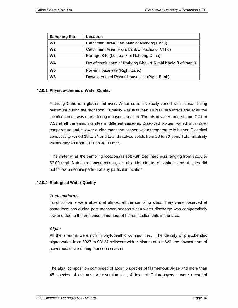
To study various parameters for aquatic ecology, survey was conducted and sampling was carried out at different sites of the proposed hydro-electric project on Rathong Chhu in pre-monsoon, monsoon and lean seasons during 2008. The samples were taken in the replicates at each site of the river. The average value was calculated for the result. Physico-chemical and biological parameters were analyzed. The sites at which sampling was done are as follows:
Shiga Energy Pvt. Ltd. Executive Summary – Tashiding HEP
R S Envirolink Technologies Pvt. Ltd. Page 36
Sampling Site Location W1 Catchment Area (Left bank of Rathong Chhu) W2 Catchment Area (Right bank of Rathong Chhu) W3 Barrage Site (Left bank of Rathong Chhu)
W4 D/s of confluence of Rathong Chhu & Rimbi Khola (Left bank)
W5 Power House site (Right Bank) W6 Downstream of Power House site (Right Bank)
4.10.1 Physico-chemical Water Quality
Rathong Chhu is a glacier fed river. Water current velocity varied with season being maximum during the monsoon. Turbidity was less than 10 NTU in winters and at all the locations but it was more during monsoon season. The pH of water ranged from 7.01 to 7.51 at all the sampling sites in different seasons. Dissolved oxygen varied with water temperature and is lower during monsoon season when temperature is higher. Electrical conductivity varied 35 to 54 and total dissolved solids from 20 to 50 ppm. Total alkalinity values ranged from 20.00 to 48.00 mg/l. The water at all the sampling locations is soft with total hardness ranging from 12.30 to 66.00 mg/l. Nutrients concentrations, viz. chloride, nitrate, phosphate and silicates did not follow a definite pattern at any particular location.
4.10.2 Biological Water Quality
Total coliforms Total coliforms were absent at almost all the sampling sites. They were observed at some locations during post-monsoon season when water discharge was comparatively low and due to the presence of number of human settlements in the area. Algae All the streams were rich in phytobenthic communities. The density of phytobenthic algae varied from 6027 to 98124 cells/cm2 with minimum at site W6, the downstream of powerhouse site during monsoon season. The algal composition comprised of about 6 species of filamentous algae and more than 48 species of diatoms. At diversion site, 4 taxa of Chlorophyceae were recorded
Shiga Energy Pvt. Ltd. Executive Summary – Tashiding HEP
R S Envirolink Technologies Pvt. Ltd. Page 37
whereas at powerhouse site 3 taxa of Chlorophyceae were recorded. At diversion site and powerhouse site, 26 species of diatoms were recorded. Chlorophyceae included Spirullina sp., Hormidium sp., Ulothrix sp., Microspora sp. and Arthospira sp. Among the Bacillariophyceae (diatoms) Achnanthes minutissima and A. linearis were predominant at sampling locations near powerhouse. No serious stresses on Rathong Chhu or Rimbi Khola could be observed. Physical and chemical characteristics health of Rathong Chhu is directly related to the presence of settlements in the immediate vicinity. Among the biological characteristics, majority of the taxa in all streams were pollution intolerant, however, presence of a few pollution tolerant species like Gomphonema sphaerophorum, Nitzschia amphibian, N. linearis is indicative of stressed condition.
Macro-invertebrates Rathong Chhu is rich in the macro-invertebrates composition. Macro-invertebrates density ranged from 374 – 1331 individuals/m2 with maximum in the upstream catchment of Rimbi Khola with Rathong Chhu. Macro-invertebrates fauna comprised of 11 families, in which Heptageniidae and Baetidae were most common and dominant at all sampling locations. Higher water discharge during monsoon resulted in lower density of macro-invertebrates at all locations.
4.11 Fish and Fisheries
The great altitudinal variation in Rangit leads to variation in fish species also and about 37 fish species have been recorded from river Rangit, which belong to families Cyprinidae, Homalopteridae, Sisoridae, Cobitidae, Schilbeidae, Channidae and Anguilidae. The data on fish and fisheries were collected from field survey and sampling and secondary sources. The fish were landed with the help of local fishermen. They were found to land fish by cast nets and hooks.
4.11.1 Fishery Survey in the Project Area
Fishing was carried out during the winter and monsoon seasons in Rathong Chhu. Local fishermen were employed to land fish. Number of fishermen were employed for fishing during winter as well as monsoon seasons. Fishermen used hooks and caste net to land fish and rarely did they use damming method to land the bottom dweller species. In addition information from fishermen were also used to collect the information on fish.
Shiga Energy Pvt. Ltd. Executive Summary – Tashiding HEP
R S Envirolink Technologies Pvt. Ltd. Page 38
4.11.2 Fish Composition
Ichthyofauna comprised of 15 species in Rathong Chhu belonging to Families Salmonidae, Cyprinidae, Sisoridae, Cobitidae and Schilbeidae. Though, during the course of survey only 13 species could be landed in both rivers. A total of 11 species were common in both streams. Exotic trout (Salmo trutta fario) has earlier been introduced in the Rimbi Khola (Carrying Capacity Studies, CISMHE, 2007), though, it could not be landed from the Rimbi Chhu during the survey. Schizothorax richardsonii and Schizothoraicthys progastus were common species in both streams and account for major capture fishery in this area. They were landed by the hooks. Acrossocheilus hexagonolepis was also important species of Kalej Khola. It was not recorded from Rimbi Chhu. These all species take upstream movement during the monsoon season. The species like Garra, Glyptothorax, Nemacheilus, Crossocheilus are rarely found in the catch by traditional method, therefore, they are not of fishery interest in these areas. Occasionally, fishermen dam a part of stream, wherein all species are found in the catch.
4.11.3 Conservation Status & Fisheries
The criterion of BCPP CAMP workshop (1997) was followed to understand the conservation status of fishes of Himalaya. Out of 25 species 13 species have been assessed for their threat category. A total of 4 species of Nemacheilus and Garra gotyla stenorhynchus are placed under ‘endangered’ category while Schizothorax ricahardsonii, Barilius vagra and G. gotyla gotyla are ‘vulnerable’
5.0 SOCIO-ECONOMIC ASPECTS The project study area is spread across two districts viz. West and South within three sub-divisions viz. Gyalzing, Soreng in west and Ravong in south. The total population of these three sub-divisions is 1,67,431. The literacy rate of Gyalzing, Soreng and Ravong sub-division are 55.4%, 62.4% and 67.31% respectively. Total population of Gyalzing sub-division is 64,419 which belong to 11,955 households and 65 villages. Scheduled Castes (SC) and Scheduled Tribes (ST) constitute 4.82% and 21.19%, respectively of the total population. The population in the age group of 0-6 years accounts for 17.12% of the total population. The sex ratio in Gyalzing is 909.
Shiga Energy Pvt. Ltd. Executive Summary – Tashiding HEP
R S Envirolink Technologies Pvt. Ltd. Page 39
There are 83 villages that fall within the study area of the proposed Tashiding H.E. Project. The total human population of these villages is 75,405 of which 16,840 belong to Schedule Tribes which constitute 22.33% of the total population. There are 13,125 household in study area.
The villages where the families whose land is likely to be acquired for the proposed project activities have been categorized as affected villages. A total of 11 Hamlets will be affected due to various components of proposed Tashiding H.E. Project. They are: Right Bank--- Lower Chungbung, Kagethang, Unglok, Ambotey Khet, Passingthang, Sanyasigaon. Left Bank---Lower Lobing, Burok, Luitelgaon, Sedang, Purethang These villages come under the jurisdiction of West Sikkim
6.0 PREDICTION OF IMPACTS
Based on the project details and the baseline environmental status, potential impacts as a result of the construction and operation of the proposed Ting Ting Hydro-electric Project have been identified.
6.1 Impacts on Land Environment
Impact of acquisition of land for project components
The proposed Ting Ting H.E. project involves acquisition of total 17.854 ha of land (14.129 ha private land and 3.725 ha forest land) and will have impact on land environment in terms of change of land use and land pollution due to various activities as per changed land use.
Environmental degradation due to immigration of Construction workers population At the time of peak construction work in the project, maximum of 350 persons may be engaged. Around 50 labourers are expected to be from the local population. Around 100 or more of the work force, which will include technical, non-technical and service class, will come from outside. The peak human manpower would be around 1010. Separate
Shiga Energy Pvt. Ltd. Executive Summary – Tashiding HEP
R S Envirolink Technologies Pvt. Ltd. Page 40
accommodation and related facilities for workers, service providers and technical staff are to be arranged. The volume of labour force is most likely will create problems of sewage disposal, solid waste management and requirement of fuel etc. Appropriate mitigating measures have been suggested in EMP. Quarrying Operations The total quantity of coarse aggregate required for concreting and masonry in the proposed diversion is about 0.16 Mm3. It is necessary to implement appropriate slope stabilization measures to prevent the possibility of soil erosion and landslides at the quarry sites. In the proposed project, it is proposed to utilize material from river bed etc. Operation of Construction Equipment During the construction phase, equipment such as crushers, batching plant, drillers, earth movers, rock bolters, etc. are required. Proper siting of these facilities is important so as to have minimum impact due to their location and operation. Efforts shall be made to select the site for locating the construction equipment in such a way that the adverse impacts on environment are minimal including that on residents of nearby villages. Soil Erosion/Increased Siltation The runoff from the construction sites will have a natural tendency to flow towards river or its tributaries. There is a possibility of increased sediment levels in river water resulting in reduction in light penetration and hence reduced photosynthetic activity to some extent. River has sufficient flow throughout the year; therefore, impacts on this account are not expected to be significant. Muck Disposal About 0.395 Mm3 of muck is expected to be generated as a result of construction of diversion structure, power house and other appurtenant works. The project proposes to utilize some part of the muck to be generated as construction material in various project structures. Therefore, some part of the muck is proposed to be dumped at three pre-identified locations in line with the topographic conditions. The muck is proposed to be dumped in an environmentally sound manner in pre-identified dumping sites, which are proposed to be rehabilitated. The details of the same have been covered in Environmental Management Plan outlined in this Report.
Shiga Energy Pvt. Ltd. Executive Summary – Tashiding HEP
R S Envirolink Technologies Pvt. Ltd. Page 41
Construction of Roads The major impacts likely to accrue as a result of construction of the roads are: • Loss of forest and vegetation by cutting of trees • Geological disturbance due to blasting, excavation, etc. • Soil erosion as the slope cutting operation disturbs the natural slope and leads to
land slips and landslides. • Interruption of drainage and change in drainage pattern • Disturbance of water resources with blasting and discriminate disposal of fuel and
lubricants from road construction machinery • Siltation of water channels/ reservoirs from excavated debris • Effect on flora and fauna • Air pollution due to dust from debris, road construction machinery, etc The indirect impact of the construction of new roads is the increase in accessibility to otherwise undisturbed areas, resulting in greater human interference and subsequent adverse impacts on the ecosystem. Appropriate management measures required to mitigate adverse environmental impacts during road construction have been recommended. The details of the same have been covered in Environmental Management Plan outlined in this report.
6.2 Impacts on Water Resources
There are about eleven villages which fall between diversion site and power house and who could be directly or indirectly dependent upon river. These are: Left Bank -- Lower Lobing, Burok, Luitelgaon, Sedang and Purethang Right Bank --Lower Chungbung, Kagethang, Kabirthang, Ambotey Khet, Passingthang and Sanyasigaon People are not dependent on Rathong Chhu for drinking water however; they use this water for irrigation. They do not get their drinking water supply from the river instead are dependent upon the streams that join the main river.
Shiga Energy Pvt. Ltd. Executive Summary – Tashiding HEP
R S Envirolink Technologies Pvt. Ltd. Page 42
6.3 Impacts on Water Quality
Sewage from Construction worker Camps The project construction is likely to last for a period of 33 months. The increase in the population is expected to be in the order of 1000. The domestic water requirement for the outside labour is in the order of 0.075 mld @ 70 lpcd. Assuming that about 80% of the water supplied will be generated as waste/ sewage. The BOD load contributed by domestic sources will be about 25 kg/ day. The minimum average flow in the Rathong Chhu is taken as 7 cumec and for the worst scenario the DO level is coming above 8 mg/l at a distance of 0.025 km from outfall and as such there will be no significant impact on stream water quality due to disposal of untreated sewage. Even then it is proposed to treat the sewage from labour camps before disposal. It is proposed to construct adequate number of septic tanks for treatment of sewage and portable sewerage treatment plants are to be provided wherever the concentration of construction labour is high. Effluent from Crushers During construction phase, at least one crusher is proposed to be commissioned at the diversion site. The total capacity of the crusher is likely to be of the order of 120-150 tph. Water is required to wash the boulders and to lower the temperature of the crushing edge. About 0.1 m3 of water is required per tonne of material crushed. The effluent from the crusher would contain high suspended solids. The quantum of effluent generated is of the order of 12-15 m3/hr. The natural slope in the area is such that, the effluent from the crushers will ultimately find its way in river through natural drains. However, no major adverse impacts are anticipated due to small quantity of effluent and large volume water available for dilution in river. However, turbidity levels in small tributaries, especially, in lean season will increase. To minimize the impact, it is proposed to treat the effluent before disposal to ameliorate even if only the marginal impacts are likely to accrue on this account. Disposal of Muck The major impact on the water quality arises when the muck is disposed along the river bank. The project authorities have identified suitable muck disposal sites which are located near the river channel.
Shiga Energy Pvt. Ltd. Executive Summary – Tashiding HEP
R S Envirolink Technologies Pvt. Ltd. Page 43
Effluent from Project Colony During the operation phase, due to absence of any large scale construction activity, the cause and source of water pollution will be much different. Only a small number of maintenance and operation staff will be stationed in the area in a well-planned colony with piped water supply and proper sewerage treatment plant. Impacts on Reservoir Water Quality The flooding of previously forest and agricultural land in the submergence area will increase the availability of nutrients resulting from decomposition of the vegetative matter. However, this phenomenon is likely to last for a short duration from the filling up of the pondage.
6.4 Impacts on Terrestrial Flora
The direct impact of construction activity for any water resource project in a mountainous terrain similar to that of proposed project is generally limited in the vicinity of the construction sites only. As mentioned earlier, a population of 1000 persons likely to congregate in the area during peak project construction phase and they may use fuel wood (if no alternate fuel is provided) Hence, to minimize such impacts, it is proposed to provide alternate fuel for cooking e.g. Kerosene, LPG to the Construction Worker force. The other alternative is to provide community kitchens on a cooperative basis by the contractor. The details of the same have been covered in Environmental Management Plan.
6.5 Impacts on Terrestrial Fauna
Disturbance to Wildlife
Based on the field survey and interaction with locals, it was confirmed that no major wildlife is reported in the proposed submergence area. It would be worthwhile to mention here that most of the submergence lies within the gorge portion. Thus, creation of a reservoir due to the proposed project is not expected to cause any significant adverse impact on wildlife movement. The project area and its surroundings are not reported to serve as habitat for wildlife nor do they are located on any known migratory route. Thus, no impacts are anticipated on this account.
Shiga Energy Pvt. Ltd. Executive Summary – Tashiding HEP
R S Envirolink Technologies Pvt. Ltd. Page 44
During construction phase, a large number of machinery and construction Worker will have to be mobilized. This activity may have some disturbance to the wildlife population. The operation of various construction equipments is likely to generate significant noise, especially during blasting. The noise may scare the fauna and force them to migrate to other areas. Therefore, project authorities would be advised to devise the activity schedule keeping in mind the animal behaviour i.e. breeding season, etc. The equipment used should have silencers and cause minimum ground vibrations during the construction period. Likewise, siting of construction equipment, godowns, stores, Construction Worker camps, etc. may generally disturb whatever fauna is left in the area. However, no large-scale fauna is observed in the area. Thus, impacts on this account are not expected to be significant.
Impacts on Migratory Routes The faunal species observed in the project area are not migratory in nature. The proposed project area is not the migratory route of wild animals.
6.6 Impacts on Aquatic Ecology
Impacts due to excavation of construction material from river bed During construction phase, a large quantity of construction material like stones, pebbles, gravel and sand would be needed. Significant amount of material is available in the river bed just downstream of diversion site. It is proposed to extract construction material from the river bed. The extraction of construction material may affect the river water quality due to increase in the turbidity levels. Good dredging practices can however, minimize turbidity. It has also been observed that slope collapse is the major factor responsible for increase in the turbidity levels. If the depth of cut is too high, there is possibility of slope collapse, which releases a sediment cloud. The dredging and deposition of dredged material may affect the survival and propagation of benthic organisms. The macro-benthic life which remains attached to the stones, boulders etc. gets dislodged and is carried away downstream by turbulent flow. The areas from where construction material is excavated, benthic fauna get destroyed. In due course of time, however, the area gets decolonized, with fresh benthic fauna. The density and diversity of benthic fauna will however, be less as compared with the pre-dredging levels. The second important impact is on the spawning areas of fishes. Almost all the cold water fish breed in the flowing waters. The spawning areas of these fish species are
Shiga Energy Pvt. Ltd. Executive Summary – Tashiding HEP
R S Envirolink Technologies Pvt. Ltd. Page 45
found amongst pebbles, gravel, sand etc. Any disturbance of stream bottom will result in adverse impacts on fish eggs. Even increase in fine solids beyond 25 ppm will result in deposition of silt over the eggs, which would result in asphyxiation of developing embryo and also choking of gills of young newly emerged fry. Thus, if adequate precautions during dredging operations are not undertaken, then significant adverse impacts on aquatic ecology are anticipated. Impacts due to discharge of sewage from Construction Worker camp/colony The proposed hydro-power project would envisage construction of temporary and permanent residential colonies to accommodate Construction Worker and staff engaged in the project. This would result in discharge of sewage which is usually discharged into the nearby water body. However, it is proposed to commission adequate number of septic tanks for treatment of domestic sewage before its disposal in to the river. Due to perennial nature of river, it maintains sufficient flow throughout the year which is sufficient to dilute the treated sewage from residential colonies. Therefore, as mentioned earlier, no adverse impacts on water quality are anticipated due to discharge of sewage from Construction worker camp/colony. Impacts due to human activities Accumulation of Construction Worker force in the project area might results in enhancement in indiscriminate fishing including use of explosives. The use of explosive material to kill fishes in the river in the project area would result in complete loss of fishes and other aquatic life making a river stretch completely barren. Indiscriminate fishing will reduce fish stock availability for commercial and sport fishermen. These aspects have been adequately covered in the Environmental Management Plan (EMP) outlined in this report. Impacts due to damming of river The damming of river will result in creation of 1.33 ha of submergence area. The diversion site will change the fast flowing river to a quiescent lacustrine environment. The creation of a pond will bring about a number of alterations in physical, abiotic and biotic parameters both in upstream and downstream directions of the proposed diversion site. The micro and macro benthic biota is likely to be most severely affected as a result of the proposed project.
Shiga Energy Pvt. Ltd. Executive Summary – Tashiding HEP
R S Envirolink Technologies Pvt. Ltd. Page 46
The positive impact of the project will be the formation of a water body which can be used for fish stocks on commercial basis to meet the protein requirement of region. The commercial fishing in the proposed reservoir would be successful, provided all tree stumps and other undesirable objects are removed before submergence. The existence of tree stumps and other objects will hinder the operation of deep water nets. The nets will get entangled in the tree stumps and may be damaged. The reduction in flow rate of river especially during lean period is likely to increase turbidity levels downstream of the diversion site. Further reduction in rate of flow may even create condition of semi-dessication in certain stretches of the river. This would result in loss of fish life by poaching. Hence, it is essential to maintain minimum flow required for sustenance of riverine fisheries till the disposal point of the tail race discharge. The project authorities have been advised to maintain sufficient amount of discharge during the lean period to maintain and sustain the aquatic ecosystem functions in this stretch. Some of the small streams will contribute to the flow of water in main channel and minimize negative impacts on the processes and structure of these aquatic ecosystems. For mitigating the downstream impacts, it is mandatory to release at least 10% of the lean season flow into the river.
Impacts on migratory fish species The stretch of Rangit river up to Jorethang is the breeding ground for mahseer. However, of late the migration of mahseer has been hampered due to the construction of Teesta Low Dam hydro-electric project (lower stretch of Teesta in West Bengal) impairing its migratory route. Therefore, mahseer presently is rarely captured in this stretch. Acrossocheilus hexagonolepis and snow trout are the local migratory fishes. A. hexagonolepis migrates to small a tributaries from the main stream while snow trout like Schizothorax richardsonii, S. progastus move downstream during summer to monsoon. In Rathong Chhu and the catchment of river Rangit capture fishery occurs mostly in lower stretch of the river up to 600 m during winter season. In monsoon it becomes significantly low due to heavy discharge and high velocity of water in the river. The important species, contributing capture fishery are Acrossocheilus hexagonolepis (Catli), Schizothorax richardsonii (Asla), Schizothoraicthys progastus (Chuche Asla), Tor putitora (mahseer) and Anguilla bengalensis (Bam). The fishermen have been issued licenses for fishing. They were found to use caste nets and hooks for fish landing. On
Shiga Energy Pvt. Ltd. Executive Summary – Tashiding HEP
R S Envirolink Technologies Pvt. Ltd. Page 47
one side the construction of Teesta Low Dam on Teesta river in West Bengal has lead to disruption of migration of mahseer upstream into Teesta river as well as Rangit river, while the proposed reservoir would encourage fisheries development in the area.
6.7 Impacts on Noise Environment
Operation of various construction equipments will generate noise and likewise, noise due to quarrying, blasting, vehicular movement will also have some adverse impact on the ambient noise levels in the area. It is estimated that under worst case scenario, increase in noise level shall be of the order of 8 dBA, within 1 km from the project area. However, it would be worthwhile to mention here that in absence of the data on actual location of various construction equipment, all the equipment have been assumed to operate at a common point. This assumption leads to over-estimation of the increase in noise levels. The walls of various houses will attenuate at least 15 to 30 dBA of noise. In addition there is attenuation due to the following factors. • Air absorption • Rain • Atmospheric inhomogeneties and atmospheric turbulence. • Vegetal foliage Thus, no increase in noise levels is anticipated as a result of various activities, during the project construction phase. The noise is also generated due to blasting during tunneling operations. However, it is not likely to have any effect on habitations. No major wildlife is observed in and around the project site. Hence, no significant impacts on wildlife are anticipated as a result of blasting activities in the proposed project.
6.8 Air Pollution
The operation of various construction equipments requires combustion of fuel. Normally, diesel is used in such equipment. The major pollutant which gets emitted as a result of combustion of diesel is SO2. The SPM emissions are minimal due to low ash content in diesel. The short-term increase in SO2, even assuming that all the equipment are operating at same point of time, is quite low, i.e. of the order of less than 1μg/m3. Hence, no major impact is anticipated on this account on ambient air quality.
Shiga Energy Pvt. Ltd. Executive Summary – Tashiding HEP
R S Envirolink Technologies Pvt. Ltd. Page 48
During crushing operations, fugitive emissions comprising mainly the suspended particulate will be generated. During layout design, care should be taken to ensure that the Construction Worker camps, colonies, etc. are located on the leeward side and outside the impact zone (say about 10 km on the wind direction) of the crushers. During construction phase, there will be increased vehicular movement. Lot of construction material like sand, fine aggregate are stored at various sites, during the project construction phase. Normally, due to blowing of winds, especially when the environment is dry, some of the stored material can get entrained in the atmosphere. However, such impacts are visible only in and around the storage sites. The impacts on this account are generally, insignificant in nature.
6.9 Impacts on Socio-Economic Environment
A project of this magnitude is likely to entail both positive as well as negative impacts on the socio-cultural fabric of area.
If the quantum of human population migrating from other areas is greater than the local human population in the area it would result in demographic changes and other repercussions that follow. Since the migrant workforce is generally from the different regions, diverse ethnic and cultural backgrounds and value systems, they are bound to affect the local socio-cultural and value systems. In addition, these migrants might be the probable carriers of various diseases not known so far in the region resulting in health risk for the local population. Positive Impacts on Socio-Economic Environment One of the main reasons for promoting hydroelectric schemes is their environmentally friendly character. This form of energy, unlike the energy from other conventional sources, entails no discharges of wastes or emission of toxic gases. It is virtually free from pollution and thus can be looked as “technology of the future” for the rural and remote areas. The following positive impacts are anticipated on the socio-economic environment of the local people of villages of project area during the project construction and operation phases: i) Expatriate constructors who would probably come from other parts of the country
would undertake construction activities.
Shiga Energy Pvt. Ltd. Executive Summary – Tashiding HEP
R S Envirolink Technologies Pvt. Ltd. Page 49
ii) A number of marginal activities and jobs would be available to the locals in the project improves the job opportunities during construction phase.
iii) Education will receive a shot in the arm. The advantage of education to secure jobs will quickly percolate through all sections of the population and will induce people to get their children educated.
iv) The availability of electricity to the rural areas will reduce the dependence of the locals on alternative energy sources namely forest.
v) With increased availability of electricity, small-scale and cottage industries are likely to come up in the area.
vi) The proposed project site is well connected by road. Efforts to be made to develop eco-tourism, which could earn additional revenue.
6.10 Increased Incidence of Water-Related Diseases
The construction of a reservoir replaces the riverine ecosystem by a lacustrine ecosystem. The vectors of various diseases breed in shallow water areas not very far from the reservoir margins. The magnitude of breeding sites for mosquitoes and other vectors in the impounded water is in direct proportion to the length of the shoreline. The construction of the reservoir would increase the shoreline as compared to the pre-project shoreline of river under submergence. Thus, the construction of the proposed pondage would enhance the potential breeding sites for various diseases vectors. There are chances that incidence of malaria may increase as a result of the construction and operation of the proposed project. In addition to the construction of the diversion, the following factors too would lead to the increased incidence of malaria in and around the project area: o aggregation of Construction Worker o excavation, and o inadequate & facilities in Construction Worker camp. Adequate measures have been recommended as a part of Environmental Management Plan to mitigate these impacts.
VOLUME II
ENVIRONMENT MANAGEMENT
PLAN
Shiga Energy Pvt. Ltd. Executive Summary – Tashiding HEP
R S Envirolink Technologies Pvt. Ltd. Page 50
1.0 BIODIVERSITY CONSERVATION & MANAGEMENT PLAN
Biodiversity Conservation and Management plan has been prepared with the objective of sustainable use of natural resources which involves scientific management of natural wealth vis-à-vis developmental activities are likely to affect these resources. The threats to natural terrestrial and aquatic ecosystems generally arise due to by anthropogenic activities that may arise as a result of construction and associated activities of proposed Tashiding H.E. project. During the construction period various activities like road construction, blasting, excavation for tunnels, quarrying, dumping of excavated material and human population pressure on land and biological resources are likely to exert tremendous pressure of the biological resources of the region and management plan will ensure mitigation of such impacts. In areas wherever natural regeneration due to biotic interference is poor it is suggested to restore such areas to their optimum productivity potential which can be accomplished by replenishment afforestation. However, some of the specific measures are: • Noise Mitigation and Management
• Habitat Improvement Programme
Afforestation Pasture Development Nursery Development
• Medicinal Plant Cultivation/ Conservation and herbal gardens
• Eco-Development Works
Compensation Publicity & Awareness Observance of Wildlife Week, Nature Club & Website development
• Anti-poaching Measures
Engagement of part-time informers & Engagement of contractual staff Purchase of anti-poaching kits Construction of watch towers & qtrs Construction of inspection paths & bridges Purchase of Survey equipment & vehicle & Communication system Monitoring of cattlesheds Construction of check posts
• Species Recovery Programme
• Establishment of Arboretum & Nature Interpretation Centre (NIC)
Shiga Energy Pvt. Ltd. Executive Summary – Tashiding HEP
R S Envirolink Technologies Pvt. Ltd. Page 51
2.0 CATCHMENT AREA TREATMENT PLAN
The Catchment Area Treatment (CAT) plan highlights the management techniques to control erosion in the catchment area of a water resource project. The life span of a reservoir is greatly reduced due to erosion in the catchment area. Adequate preventive measures are thus needed for the treatment of catchment for its stabilization against future erosion. Catchment Area Treatment Plan has been formulated for free draining catchment at proposed diversion site i.e. catchment below proposed RANGIT II and proposed Ting Ting H. E. Projects have been considered for the study. `Silt Yield Index’ (SYI), method has been used, where the terrain is subdivided into various watersheds and the erodibility is determined on relative basis. In the present report, CAT Plan as per the slope, land use pattern, soil characteristics has been suggested based on the prioritization of watersheds using SYI method. The CAT plan has been suggested for sub watersheds with very high and high erosion categories as the cost for treatment for such watersheds is to be borne by the project proponents. Following activities have been suggested and budgeted for in the cost to implement EMP:
1. Engineering measures
• Dry stone wall • Dry stone sausage wall • CCM wall • Catch water drain (box drain)
Shiga Energy Pvt. Ltd. Executive Summary – Tashiding HEP
R S Envirolink Technologies Pvt. Ltd. Page 52
3.0 FISHERIES CONSERVATION PLAN To sustain biodiversity and fisheries in rivers requires sustainable management both of habitats and systems of exploitation. The fishes are considered to be highly prone to the changes in the flow pattern in downstream and upstream of the divserion structure during the operation of the project and degradation river water during construction. The altered habitat may result in the destruction of breeding grounds of the fish downstream of the barrage. On the contrary, creation of a reservoir would provide ample opportunities for fisheries development in the region.
Following measures have been suggested to for fisheries conservation: Check Dams A check dam across the river is one of measures of water resource management in the stretch with reduced water flow. They are used for different purposes, viz. irrigation, domestic and livestock’s use in lean season and fisheries. Pools in the river course in the downstream stream stretch should be maintained by creating small check dams considering the breeding behaviour of trout, which spawns in the shallow pools and the trout lay eggs from March to late April during the lower flow period. The check dams generally consist of wooden posts, earth and clay-filled sacks forming a wall of about 3-4m height. These pools approximately of 1km length should have regular water supply from the mandatory release of water (at least 10%) from the dam. Creation of Artificial Riffles Riffles and pools are important not only for the river ecology but in the river management also. Riffle is shallow water zone, where water flows rapidly over a gravel bed. These riffles play an important role in the connectivity and provide breeding grounds for the fish. The construction of artificial riffles is a part of the proposed fisheries conservation plan. Reservoir Fishery Plan The introduction of any exotic fish in the proposed reservoir may not be feasible vis-a-vis conservation of native species. Therefore, indigenous species are suggested for the reservoir. Based upon the present fish fauna observed in river Rangit and considering its location in a sub-tropical region, Mahseer and other commercial carps (Catla catla,
Shiga Energy Pvt. Ltd. Executive Summary – Tashiding HEP
R S Envirolink Technologies Pvt. Ltd. Page 53
Labeo rohita and Cirrhinus mrigala) seem to be the most appropriate for development of reservoir fisheries for commercial purposes.
4.0 PUBLIC HEALTH DELIVERY SYSTEM
Project construction and operation will bring about several changes in the socio-economic environment of the area including increased threats to the health of the community. Project construction phase will lead to influx of outside population – temporary and permanent, thereby, putting stress on existing infrastructure and will increased potential of various infectious diseases, which are not present in the area. Further, creation of reservoir will have increase the potential of vector borne diseases. Such threats to Public Health have been identified and the management measures suggested along with budget. Following activities have been budgeted as part of the project for Public health Delivery System:
• One fully equipped ambulance • Two first aid posts including sheds, furniture and basic equipment • Budget for strengthening existing medical facilities • Budget for Health Awareness/ Vaccination Camps • Budget for combating communicable diseases • Budget for combating vector borne diseases
5.0 SOLID WASTE MANAGEMENT PLAN
The construction of the proposed Tashiding hydroelectric project will involve different categories of manpower like labour, technical, other officials and service providers. living in temporary and permanent colonies / settlements. Large amount of solid waste and wastewater will be generated from these areas. An efficient waste management system will be required to put in place to keep the environment of the region clean and healthy. These colonies and temporary settlements will also require adequate water supply for drinking and cleaning. The project authorities will ensure sewage treatment from the colonies of labors and workers, water supply, cleaning of the colony area and solid waste disposal. Dwellings will be provided with septic tanks and soak pits along with water supply for drinking and other daily needs for each and proper waste disposal by adopting various disposable methods. Following activities have been planned as part of Solid Waste Management and budgeted for in the EMP: • Masonry Vats (2 No) • Community toilets for labors (3 sets)
Shiga Energy Pvt. Ltd. Executive Summary – Tashiding HEP
R S Envirolink Technologies Pvt. Ltd. Page 54
• Septic tanks and soak pits (4 pits) • Water supply system for labor colony • Solid waste management - collection, transportation and disposal at land fill site
6.0 FOREST PROTECTION PLAN
During construction phase of the hydroelectric project, migration of labour, road development, etc will be carried out. It is the general tendency that the migrant laborers will use forest wood for the fuel purpose, creating biotic pressure on the forest. To mitigate such impacts, following measures will be adopted to help minimize pressure on forest. Energy Conservation Measures Under energy conservation measures activities planned include provision of kitchen fuel such as LPG and Kerosene to migrant labours on subsidized rates to avoid cutting of trees; setting up of community kitchen and canteen to provide subsidized food to labour and supply of pressure cookers for efficient cooking and fuel saving.
Landscaping and Restoration of Construction Areas Different project related activities will require forest and private land. The acquired land will also be used for dumping of muck and other garbage from the colony area. There will be indirect disturbance to the area due to increase in the human population and traffic movement. It will be essential for the project authority to restore the area back to its original state. Following activities will be undertaken for restoration work:
• Reclamation and Phytoremediation
Collection of microflora from the field Nursery development Plantation and maintenance of successfully colonized seedings
• Laboratory Works including Selection, culturing and maintenance of strains,
Preparation of mother cultures and confirmation of successful colonization
• Roadside plantation
Green Belt Development A green belt around the reservoir will be created to avoid erosion of soil and prevention of land slips from the direct draining catchment into the reservoir.
Shiga Energy Pvt. Ltd. Executive Summary – Tashiding HEP
R S Envirolink Technologies Pvt. Ltd. Page 55
7.0 MUCK DISPOSAL PLAN The total quantity/volume of material (muck) to be dug out or excavated during the construction of various project components is estimated to be 3.95 lakh cubic meters. This excavated material with 40% swell factor of muck will be required to be rehabilitated. Most of the excavated material is proposed to be dumped at five suitable locations identified specifically for this purpose viz. Dumping site for Barrage and part HRT: Muck dumping site for Barrage and HRT will be on the right bank of Rathang Chhu near the adit portal.
Dumping sites for Surge shaft / Penstock & balance HRT: These two sites will be near road taking off for the Surge Shaft Bottom area from the existing Geyzing –Tashiding road. Dumping sites for Power House & TRC:-Muck dumping area has been identified on right bank near power house site. Also the area identified for switch yard site can be used for muck dumping from power house excavation as the level of the area is required to be raised for making a flat ground for switchyard. These proposed locations are spread over land area of 5.96 ha. Most of the total
unused excavated material would be piled at an angle less than the angle of repose i.e.
< 25° at the proposed dumping sites. Suitable retaining walls shall be constructed to
develop terraces so as to support the muck on vertical slope and for optimum space
utilization. Loose muck would be compacted layer wise. The muck disposal area will be
developed in a series of terraces of retention walls. For retaining the dumped/unused
material for subsequent stabilization along the hill slopes and along the stretch of the
road sausage-cum-retaining walls shall be developed. These will be built prior to the
dumping of muck at these sites.
The project authorities would ensure that the dumping yards blend with the natural
landscape by developing the sites with gentle slopes, bunds, terraced and water ponds,
patches of greenery in and around them. These sites can also be developed later as
recreational parks and tourists spots with sufficient greenery by planting ornamental
plants. Engineering and biological measures have been proposed for the development
of spoil areas.
Shiga Energy Pvt. Ltd. Executive Summary – Tashiding HEP
R S Envirolink Technologies Pvt. Ltd. Page 56
8.0 AIR & WATER ENVIRONMENT MANAGEMENT PLAN
Air Environment Construction and operation of the Tashiding HEP will definitely change the air quality of the area. Three years construction period will involve exploration activities, construction of tunnels and approach roads, operation of batch mixing plants, crushers and other construction equipments, operation of DG sets for back up power, quarrying operations and transportation of men and material, etc. All these activities will contribute to air pollution in the area. The nature and extent of impact on air environment will vary from time to time and through different stages of development of the project. The project authorities will work closely with representatives from the community living in the vicinity of project area to identify areas of concern and to mitigate dust-related impacts effectively. Noise Environment The sound will be generated at the time of construction of powerhouse tunnel boring machine operations, pumps, drilling machines, blasting, dumpers etc. The Construction phase will generate noise at various locations in the project area and is likely to affect residents and construction workers. Increase in vehicular traffic in the area will also contribute to high sound levels in the area. Impacts due to high noise levels can be greatly reduced by adopting mitigation measures such as location of equipment, adequate maintenance, traffic management, activity planning to avoid night time disturbance provision of PPEs, etc. as detailed in the report. Water Environment During the construction of tunnels, shaft and power house installations, surface water
(river/ stream water) may get polluted due to the generation of large quantities of
suspended particulate matter at the time of transportation of muck and wastewater
(sewage) coming from temporary arrangements like offices, labour camps, sheds, etc.
Mitigation measures such as waste segregation, avoiding accumulation of oil flows,
treatment of toxic wastes, constant monitoring will be implemented to minimize such
impacts.
Shiga Energy Pvt. Ltd. Executive Summary – Tashiding HEP
R S Envirolink Technologies Pvt. Ltd. Page 57
9.0 Compensatory Afforestation Plan
The land required for the construction of Tashiding hydroelectric project activities are approximately 17.854 ha with a component of 3.725 ha of forestland. The diversion of total forestland for Tashiding H.E. project involved 3.725 ha which will be acquired by SPDC. As per the guidelines of F.C.A. block plantation is to be taken up two times of the land diversion (3.725 x 2 = 7.45 ha). So that the compensatory afforestation to be taken up on 7.45 ha on forestland in the denuded or degraded forest areas, it is also proposed to have avenue plantation along the proposed roads with bamboo basket fencing work around the new plantation with angle iron in the diverted land to maintain the ecological balance of the areas.
The location would be selected during the joint survey of land by Department of Forest, Department of Land Revenue, S.P.D.C., Panchayat, and Developer. The objective of the afforestation programme will be to develop natural areas in which ecological functions could be maintained on sustainable basis. Therefore planting of miscellaneous indigenous species would be undertaken.
10.0 REHABILITATION & RESETTLEMENT PLAN
A detailed socio-economic survey of the families whose land is likely to be acquired for the project was conducted. The family-wise door-to-door survey was conducted based upon a list of project affected families. The list contained names of 30 project affected families.
Total 17.854 ha of land is likely to be acquired by the project authorities for the different components of the project viz. submergence, barrage structure, colonies and dumping areas, etc. 3.725 ha of forest land and 14.129 ha of private would be acquired for the different activities. A total of 10 Hamlets will be affected due to land acquisition, they are: Right Bank--- Lower Chungbung, Kagethang, Unglok, Ambotey Khet, Passingthang, Sanyasigaon. Left Bank---Lower Lobing, Burok, Luitelgaon, Sedang Out of 30 land owners, only 7 own more than 1 hectare of land and out of these 7, four will be left with less than 1 hectare of land after acquisition. Therefore, out of 30, 27 PAFs can be termed as marginal farmers and they will be entitled for additional compensation.
Shiga Energy Pvt. Ltd. Executive Summary – Tashiding HEP
R S Envirolink Technologies Pvt. Ltd. Page 58
In addition to land, two land owners will also lose immovable property in the form of residential structure – one in Lobin and one in Omlock block. Four land owners will lose 100% of the land owned by them. The resettlement and rehabilitation plan for the project affected families/ persons of the proposed Tashiding Hydro Electric Project has been formulated within the provisions and/or guidelines as given in the National Resettlement and Rehabilitation Policy for the Project Affected Persons (NRRP – 2007), formulated by the Department of Land Resources, Ministry of Rural Development. It includes Subsistence grant to Marginal Farmers; Rehabilitation Grant, Vocational training and Scholarship for Child education, etc. To implement R&R plan, the State Government shall appoint an officer of the rank of
Commissioner/ Secretary of that government for R&R in respect of such projects to
which this policy (NRRP-2007) applies. The commissioner shall be responsible for
supervising the formulation of R&R plans/schemes, proper implementation of such
plans/schemes and redressal of grievances.
As a part of Corporate Social Responsibility, project developer would aim at the
improvement in the living standards of inhabitants in the project area by not only by
being a catalyst for development but also will develop infrastructure in the area. The
infrastructure development will be other than rightful compensation to the project
affected families.
11.0 ENVIRONMENTAL MONITORING PROGRAMME
Based on the findings of the Environmental Impact Assessment study, various
Environmental Management Plans viz. Catchment Area Treatment, Biodiversity
Conservation & Management, Public Health Delivery System, Fisheries Development,
Relocation & Rehabilitation of Dumping Sites, Landscaping and Restoration of
Construction Area, Creation of Green Belt, etc. have been proposed. In order to monitor
the impact and efficacy of these plans a number of parameters have been proposed
during and after the completion of the management plans.
Shiga Energy Pvt. Ltd. Executive Summary – Tashiding HEP
R S Envirolink Technologies Pvt. Ltd. Page 59
12.0 SUMMARY OF COSTS
An amount of Rs. 466.76 lakhs has been allocated for the implementation of different environment management plans. The summary of total cost estimates for the execution of different plans is given in below. Sl. No. Component of EMP Cost (Rs. In lakhs)
1 Biodiversity Conservation Management Plan 88.402 Action Plan for Catchment Area Treatment 63.483 Fisheries Management 30.594 Public Health Delivery System 29.005 Solid Waste Management 15.006 Energy Conservation Measures 18.007 Landscaping and Restoration of Construction Areas 10.008 Creation of Green Belt 2.009 Dumping Sites and Muck Disposal Plan 125.00
10 Resettlement and Rehabilitation Plan 65.2911 Environmental Monitoring Programme 20.00
Total 466.76*The cost for Compensatory Afforestation and Net Present Value (NPV) not included. The cost of land to be acquired is also not included.