Agriculture and Rural Development | Food Security in Africa → EO4SD – EARTH OBSERVATION FOR SUSTAINABLE DEVELOPMENT eo4sd agriculture and rural development The Global Environment Facility Integrated Approach Pilot Program (IAP) on Sustainability and Resilience for Food Security in sub-Saharan Africa
Transcript
Agriculture and Rural Development | Food Security in Africa
→ EO4SD – EARTH OBSERVATION FOR SUSTAINABLE DEVELOPMENT
eo4sd
agriculture andrural development
The Global Environment Facility Integrated Approach Pilot Program (IAP) on Sustainability and Resilience for Food Security in sub-Saharan Africa
TABLE OF CONTENT
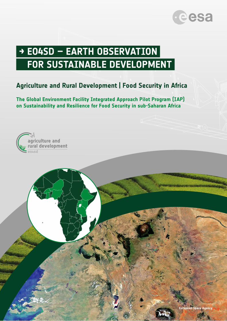
Cover image Satellite image over Kenya, Tanzania and Uganda.Credit: European Space Agency
1. INTRODUCTION 3
2. OBJECTIVES 4
3. OUTCOME 6
4. CAPACITY BUILDING 14
→ EO4SD Agriculture and Rural Development - Food Security in Africa3
1. INTRODUCTION
Achieving food security is one of the greatest challenges overall in Africa, but especially in Sub-Saharan Africa. Africa’s agricultural productivity is very low, cereal yields, for example, are notoriously low compared with other regions of the world. East and Southern Africa is increasingly experiencing decreasing yield outputs due to low resilience of agro-ecosystems to climate change impacts, droughts and other environmental disasters. Declining yields as well as a rapidly increasing population put increased pressure on landscapes, which are often unprotected and freely exploited. These unprecedented challenges are often poorly understood yet pose opportunities to develop initiatives for moving towards increased sustainability and resilience of food production systems.
Development priorities for the agriculture sector in Africa range from preventing land degradation, such as erosion and desertification, to increasing land and water productivity. In this context reliable tools and information systems are essential to support planning of sustainable food security interventions, track the progress of investments over time, and resolve agriculture and ecosystem services questions.
The Global Environment Facility’s (GEF) Integrated Approach Pilot (IAP) program on “Fostering Sustainability and Resilience for Food Security in Africa” (IAP-FS) targets agro-ecological systems in twelve African countries in the dryland regions, which face the greatest threat of environmental degradation in smallholder farms. Therefore, they are well placed to harness good practices for long-term sustainability and resilience of food production by reducing land degradation and biodiversity loss, recovering natural vegetation and increasing soil carbon.
IAP Food Security is comprised of one cross-cutting regional level project called Regional Hub and twelve country-level projects. One of the main functions of the Regional Hub is to establish a monitoring and evaluation (M&E) system to ensure timely reporting on IAP program level indicators. Conservation International (CI) through Vital Signs is leading the work on designing a regional monitoring and assessment framework for the program. Via Vital Sign’s resilience atlas1 biophysical as well as socio-economic indicators can be accessed for all the 12 countries.
Currently, traditional agricultural and land degradation monitoring systems rely heavily on scarce in situ measurements and statistics, while standardisation of methodologies and coordination of data acquisition between and within countries are missing. Moreover, data are fragmented and generated by a variety of measurement methodologies and tools producing seldom comparable results.
Earth Observation (EO)-based technology is exceptionally well suited to support the implementation of long-term and large scale development programs resolving the data and information gaps concerning the status and change in land cover/land use, vegetation cover, agricultural production and water productivity.
1 https://foodsecurityiap.resilienceatlas.org (accessed September 2019)
“Sustainable and Resilience for Food Security in sub-Saharan Africa” is the new Global Environmental Facility flagship program with a specific focus on natural resources – land, soil, water, vegetation and genetic resources.
It is led by the International Fund for Agricultural Development (IFAD) in coordination with six other GEF Agencies (UNEP, FAO, UNDP, World Bank, Conservation International and UNIDO) and involving twelve countries – Burkina Faso, Burundi, Ethiopia, Ghana, Kenya, Malawi, Niger, Nigeria, Senegal, Swaziland, Tanzania and Uganda – located in dryland regions where the threats of environmental degradation and food insecurity are greatest. The total value of the “IAP Food Security” program is approx. $115 million in GEF grants (plus approx. $650 million in co-financing), including $10.8 million for the IAP-FS Regional Hub project.
→ EO4SD Agriculture and Rural Development - Food Security in Africa4 4
The launch of the European Union Sentinel satellites as part of the Copernicus program makes an unprecedented amount of free and open data available. The Sentinel satellites carry both optical and radar sensors and provide images at multiple spatial scales, ensuring adequate access to timely information. Especially when coupled with appropriate ground information and local expertise, Earth Observation is a powerful tool to support and inform statistics and comply with reporting obligations.
This document presents the potential of EO-based information and services to contribute in an effective way to the GEF IAP-FS program. The purpose is to demonstrate and raise awareness among MDBs and their local stakeholders in the sub-Saharan Africa region of the important added value of EO for M&E, and the EO capacity building, for their IAP country projects as well as the IAP Regional Hub.
2. OBJECTIVES
The Global Environment Facility Integrated Approach Pilot (IAP) on sustainability and resilience for food security in sub-Saharan Africa is one of the target programs of the EO4SD (Earth Observation for Sustainable Development) “Agriculture and Rural Development Cluster”. The objective of this cluster was, among other things, to support and complement activities envisaged under the GEF Program with EO services and capacity for Monitoring and Evaluation (M&E), at both IAP country projects and regional levels. M&E activities of the IAP program and its projects play an important role by tracking progress towards fulfillment of the mission to deliver global environmental benefits. Monitoring activities use systematic collection of data to keep activities on track, whilst evaluation activities are a systematic assessment of an activity (program or project) that assesses relevance, effectiveness, efficiency, results and sustainability. This information allows to those in charge of implementing project and programs to maintain sufficient flexibility in responding to a potential change of circumstances. EO4SD is a European Space Agency (ESA) initiative which aims at mainstreaming the use of Earth Observation information products and services at large scale for international development projects.
eo4sd
agriculture andrural development
The EO4SD IAP-FS target partners are:
• IFAD as the lead agency for the GEF IAP program and its “Program Management Unit” based in Addis Ababa for program implementation,
• World Agroforestry Center (ICRAF) in Nairobi where the IAP Regional Hub Coordination Unit (PCU) is based,
• Conservation International (CI) mandated to improve geospatial monitoring and evaluation within the IAP Regional Hub by developing the indicators framework leveraging CI’s open source data system – Vital Signs, and
• the IAP-FS national implementing agencies in Burkina Faso, Ethiopia, Malawi, Niger and Uganda who are tasked with developing IAP program national level indicators and decision-support tools for their specific investment projects.
EO4SD - Agriculture and Rural Development Cluster project - aims at demonstrating the benefits of EO-based information and services to support agricultural monitoring and management. The services include land cover/land use mapping, agricultural production assessments, land degradation monitoring, soil erosion risk mapping and irrigation suitability and performance.
→ EO4SD Agriculture and Rural Development - Food Security in Africa5
Services provided by the EO4SD Agriculture Cluster make independent and authoritative environmental variables available in order to build up a stronger indicator framework addressing drivers of environmental degradation and agro-ecosystem resilience, delivering food security outcomes and generating global environmental benefi ts across multiple scales.
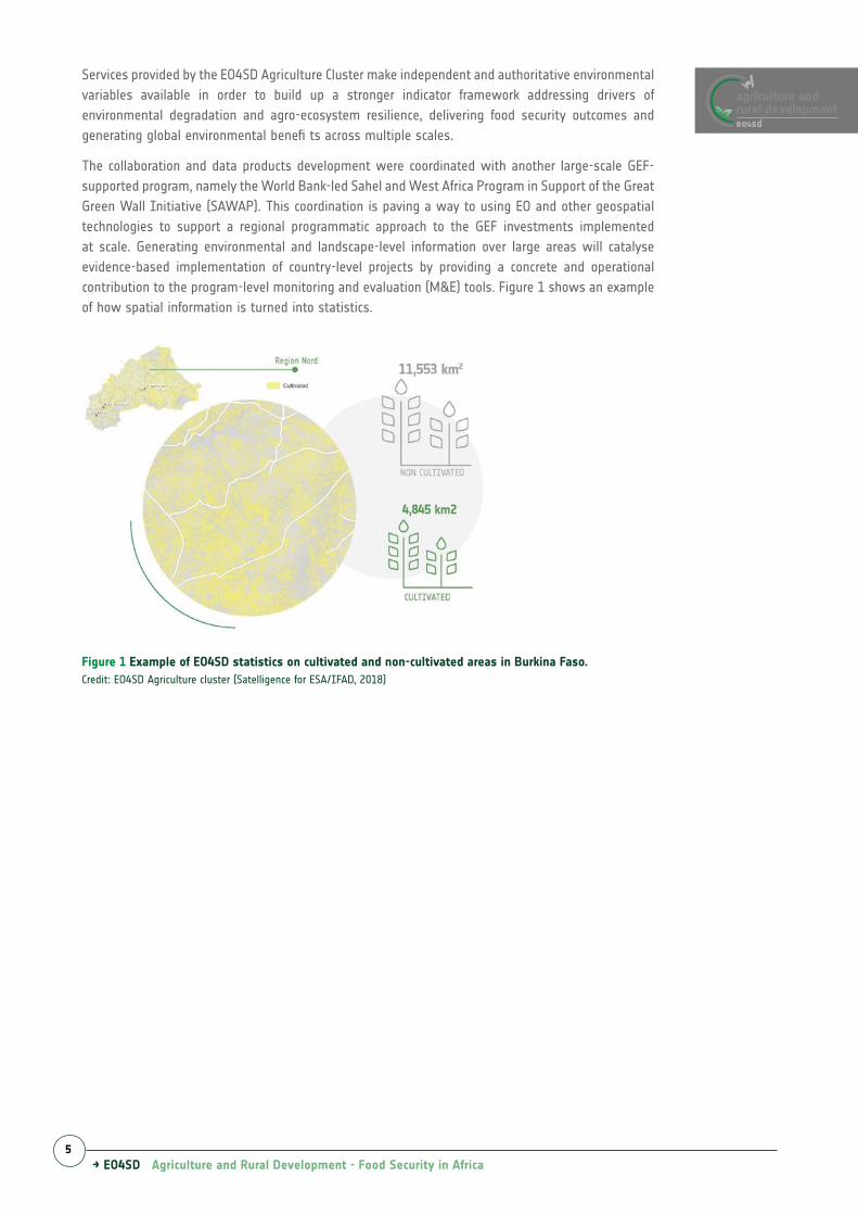
The collaboration and data products development were coordinated with another large-scale GEF-supported program, namely the World Bank-led Sahel and West Africa Program in Support of the Great Green Wall Initiative (SAWAP). This coordination is paving a way to using EO and other geospatial technologies to support a regional programmatic approach to the GEF investments implemented at scale. Generating environmental and landscape-level information over large areas will catalyse evidence-based implementation of country-level projects by providing a concrete and operational contribution to the program-level monitoring and evaluation (M&E) tools. Figure 1 shows an example of how spatial information is turned into statistics.
Figure 1 Example of EO4SD statistics on cultivated and non-cultivated areas in Burkina Faso.Credit: EO4SD Agriculture cluster (Satelligence for ESA/IFAD, 2018)
eo4sd
agriculture andrural development
→ EO4SD Agriculture and Rural Development - Food Security in Africa6
3. OUTCOME
The EO4SD Agriculture Cluster has developed a range of land information services that have been delivered to the IAP Food Security stakeholders in the form of mapping and monitoring tools and training activities (see chapter 4 for more details). EO4SD contributed to the datasets provided by Vital Signs with high resolution information on land cover/land use, biomass production, agricultural water productivity, water consumption (and deficit) and potential soil erosion risk by water with special focus on for IAP project areas in Burkina Faso, Ethiopia and Uganda. Using synergies of the EO4SD Water Cluster, information was also provided to teams in Malawi and Niger. In addition to the EO4SD generated data, open access data from ESA, such as datasets developed under the ESA Climate Change Initiative (CCI+) including high resolution land cover dataset for the entire African continent which was produced in the framework of ESA and the Copernicus program initiatives were also provided.
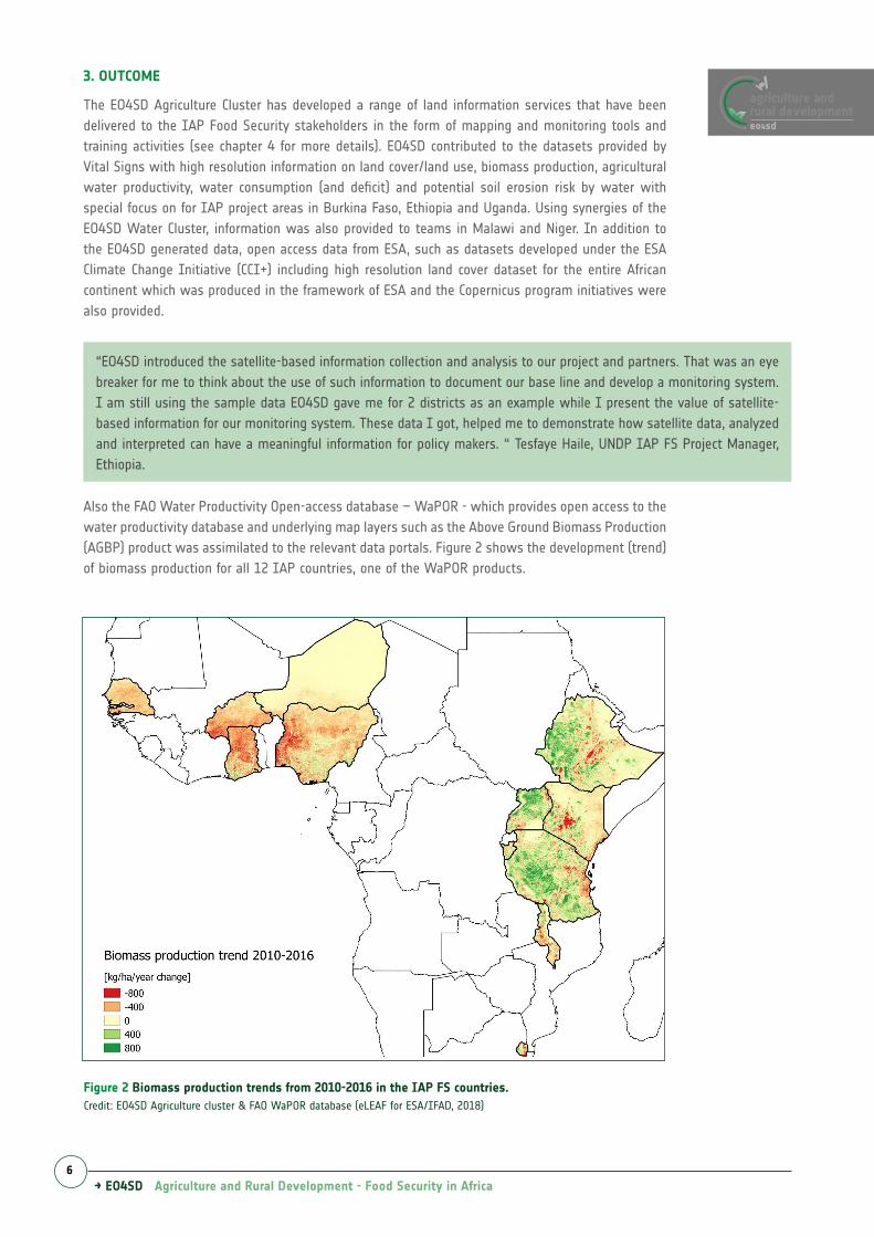
Also the FAO Water Productivity Open-access database – WaPOR - which provides open access to the water productivity database and underlying map layers such as the Above Ground Biomass Production (AGBP) product was assimilated to the relevant data portals. Figure 2 shows the development (trend) of biomass production for all 12 IAP countries, one of the WaPOR products.
“EO4SD introduced the satellite-based information collection and analysis to our project and partners. That was an eye breaker for me to think about the use of such information to document our base line and develop a monitoring system. I am still using the sample data EO4SD gave me for 2 districts as an example while I present the value of satellite-based information for our monitoring system. These data I got, helped me to demonstrate how satellite data, analyzed and interpreted can have a meaningful information for policy makers. “ Tesfaye Haile, UNDP IAP FS Project Manager, Ethiopia.
Figure 2 Biomass production trends from 2010-2016 in the IAP FS countries. Credit: EO4SD Agriculture cluster & FAO WaPOR database (eLEAF for ESA/IFAD, 2018)
eo4sd
agriculture andrural development
→ EO4SD Agriculture and Rural Development - Food Security in Africa7
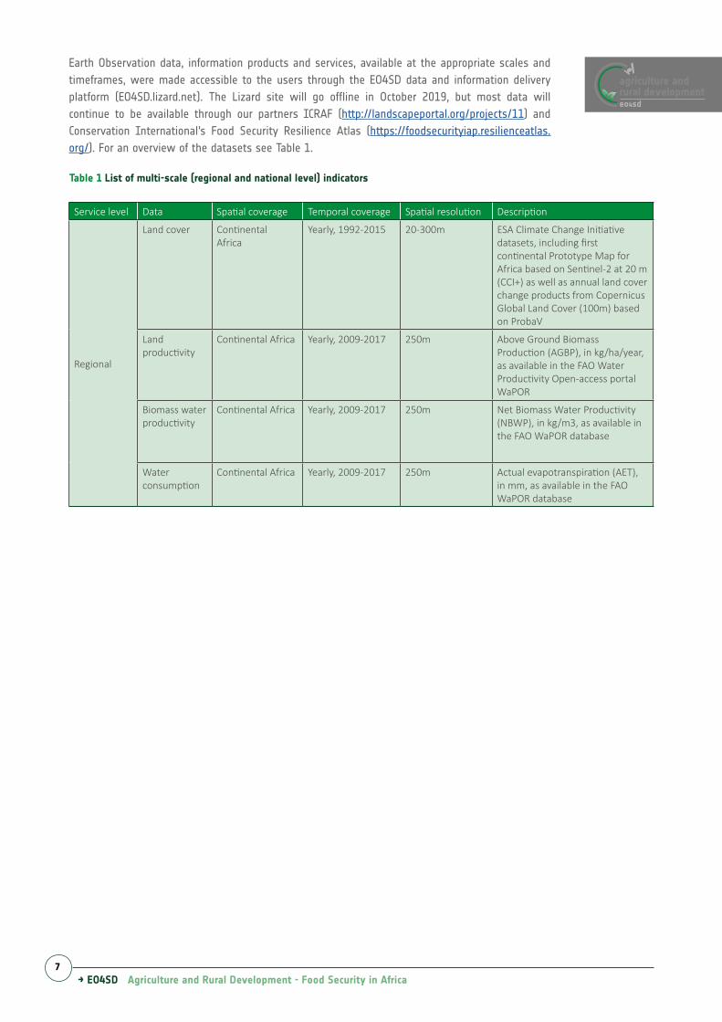
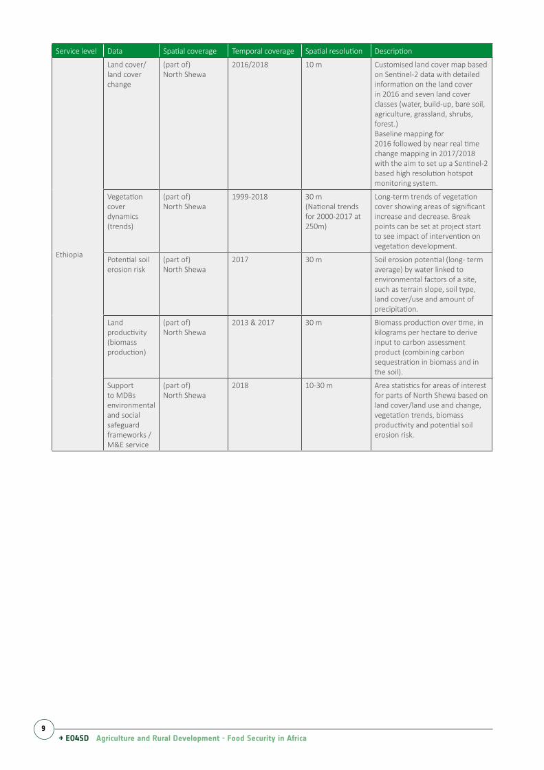
Service level Data Spatial coverage Temporal coverage Spatial resolution Description
Regional
Land cover ContinentalAfrica
Yearly, 1992-2015 20-300m ESA Climate Change Initiative datasets, including first continental Prototype Map for Africa based on Sentinel-2 at 20 m (CCI+) as well as annual land cover change products from Copernicus Global Land Cover (100m) based on ProbaV
Land productivity
Continental Africa Yearly, 2009-2017 250m Above Ground Biomass Production (AGBP), in kg/ha/year, as available in the FAO Water Productivity Open-access portal WaPOR
Biomass water productivity
Continental Africa Yearly, 2009-2017 250m Net Biomass Water Productivity (NBWP), in kg/m3, as available in the FAO WaPOR database
Water consumption
Continental Africa Yearly, 2009-2017 250m Actual evapotranspiration (AET), in mm, as available in the FAO WaPOR database
Table 1 List of multi-scale (regional and national level) indicators
Earth Observation data, information products and services, available at the appropriate scales and timeframes, were made accessible to the users through the EO4SD data and information delivery platform (EO4SD.lizard.net). The Lizard site will go offline in October 2019, but most data will continue to be available through our partners ICRAF (http://landscapeportal.org/projects/11) and Conservation International’s Food Security Resilience Atlas (https://foodsecurityiap.resilienceatlas.org/). For an overview of the datasets see Table 1.
→ EO4SD Agriculture and Rural Development - Food Security in Africa8
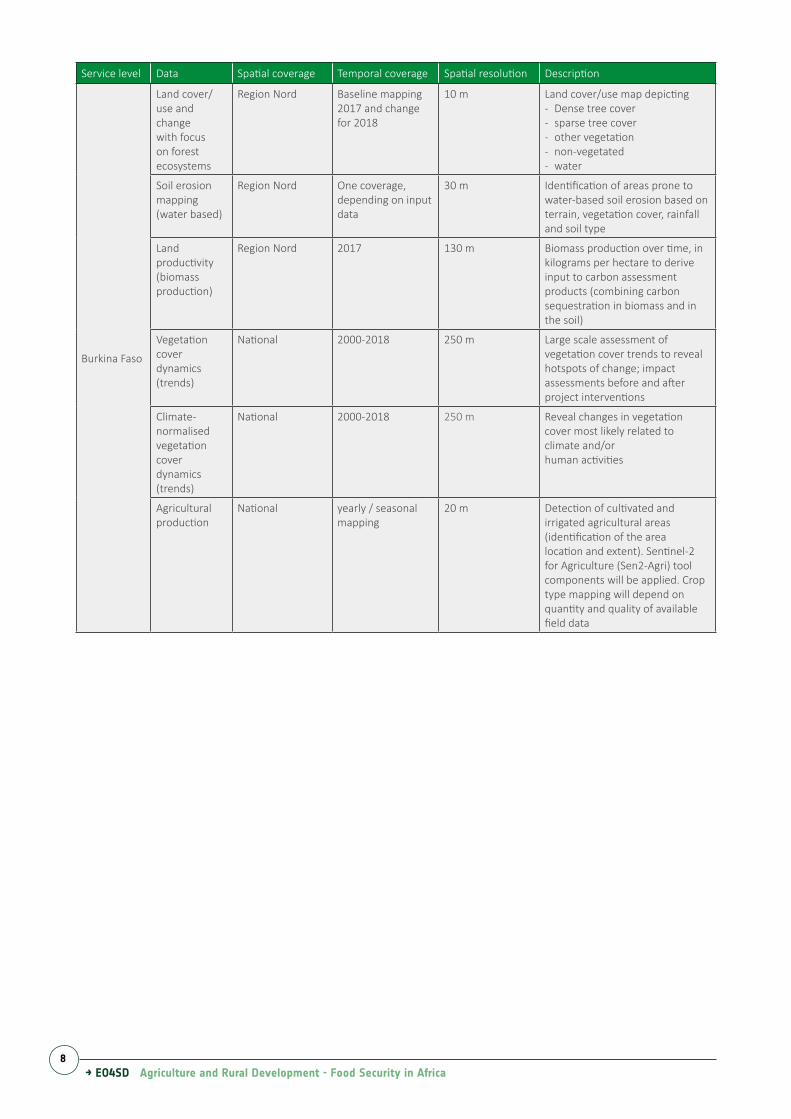
Service level Data Spatial coverage Temporal coverage Spatial resolution Description
Burkina Faso
Land cover/ use and change with focus on forest ecosystems
Region Nord Baseline mapping 2017 and changefor 2018
10 m Land cover/use map depicting- Dense tree cover- sparse tree cover- other vegetation- non-vegetated- water
Soil erosion mapping (water based)
Region Nord One coverage, depending on input data
30 m Identification of areas prone to water-based soil erosion based on terrain, vegetation cover, rainfall and soil type
Land productivity (biomass production)
Region Nord 2017 130 m Biomass production over time, in kilograms per hectare to derive input to carbon assessment products (combining carbon sequestration in biomass and in the soil)
Vegetation cover dynamics (trends)
National 2000-2018 250 m Large scale assessment of vegetation cover trends to reveal hotspots of change; impact assessments before and after project interventions
National 2000-2018 250 m Reveal changes in vegetation cover most likely related to climate and/orhuman activities
Agricultural production
National yearly / seasonal mapping
20 m Detection of cultivated and irrigated agricultural areas (identification of the area location and extent). Sentinel-2 for Agriculture (Sen2-Agri) tool components will be applied. Crop type mapping will depend on quantity and quality of available field data
→ EO4SD Agriculture and Rural Development - Food Security in Africa9
Service level Data Spatial coverage Temporal coverage Spatial resolution Description
Ethiopia
Land cover/land cover change
(part of)North Shewa
2016/2018 10 m Customised land cover map based on Sentinel-2 data with detailed information on the land cover in 2016 and seven land cover classes (water, build-up, bare soil, agriculture, grassland, shrubs, forest.)Baseline mapping for2016 followed by near real time change mapping in 2017/2018 with the aim to set up a Sentinel-2 based high resolution hotspot monitoring system.
Vegetation cover dynamics (trends)
(part of)North Shewa
1999-2018 30 m(National trends for 2000-2017 at 250m)
Long-term trends of vegetation cover showing areas of significant increase and decrease. Break points can be set at project start to see impact of intervention on vegetation development.
Potential soil erosion risk
(part of)North Shewa
2017 30 m Soil erosion potential (long- term average) by water linked to environmental factors of a site, such as terrain slope, soil type, land cover/use and amount of precipitation.
Land productivity (biomass production)
(part of)North Shewa
2013 & 2017 30 m Biomass production over time, in kilograms per hectare to derive input to carbon assessment product (combining carbon sequestration in biomass and in the soil).
Support to MDBs environmental and social safeguard frameworks / M&E service
(part of)North Shewa
2018 10-30 m Area statistics for areas of interest for parts of North Shewa based on land cover/land use and change, vegetation trends, biomass productivity and potential soil erosion risk.
→ EO4SD Agriculture and Rural Development - Food Security in Africa10
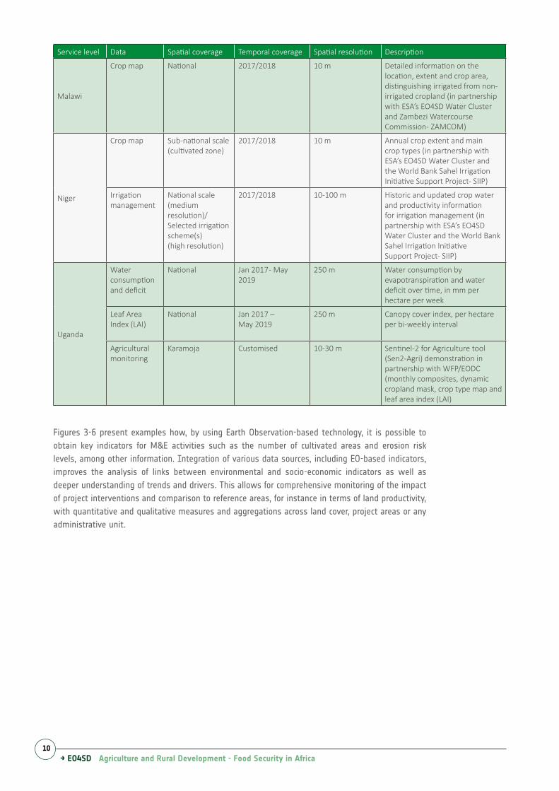
Service level Data Spatial coverage Temporal coverage Spatial resolution Description
Malawi
Crop map National 2017/2018 10 m Detailed information on the location, extent and crop area, distinguishing irrigated from non- irrigated cropland (in partnership with ESA’s EO4SD Water Cluster and Zambezi Watercourse Commission- ZAMCOM)
Niger
Crop map Sub-national scale (cultivated zone)
2017/2018 10 m Annual crop extent and main crop types (in partnership with ESA’s EO4SD Water Cluster and the World Bank Sahel Irrigation Initiative Support Project- SIIP)
Irrigation management
National scale (medium resolution)/ Selected irrigation scheme(s)(high resolution)
2017/2018 10-100 m Historic and updated crop water and productivity informationfor irrigation management (in partnership with ESA’s EO4SD Water Cluster and the World Bank Sahel Irrigation InitiativeSupport Project- SIIP)
Uganda
Water consumption and deficit
National Jan 2017 - May 2019
250 m Water consumption by evapotranspiration and water deficit over time, in mm per hectare per week
Leaf Area Index (LAI)
National Jan 2017 –May 2019
250 m Canopy cover index, per hectare per bi-weekly interval
Agricultural monitoring
Karamoja Customised 10-30 m Sentinel-2 for Agriculture tool (Sen2-Agri) demonstration in partnership with WFP/EODC (monthly composites, dynamic cropland mask, crop type map and leaf area index (LAI)
Figures 3-6 present examples how, by using Earth Observation-based technology, it is possible to obtain key indicators for M&E activities such as the number of cultivated areas and erosion risk levels, among other information. Integration of various data sources, including EO-based indicators, improves the analysis of links between environmental and socio-economic indicators as well as deeper understanding of trends and drivers. This allows for comprehensive monitoring of the impact of project interventions and comparison to reference areas, for instance in terms of land productivity, with quantitative and qualitative measures and aggregations across land cover, project areas or any administrative unit.
→ EO4SD Agriculture and Rural Development - Food Security in Africa11
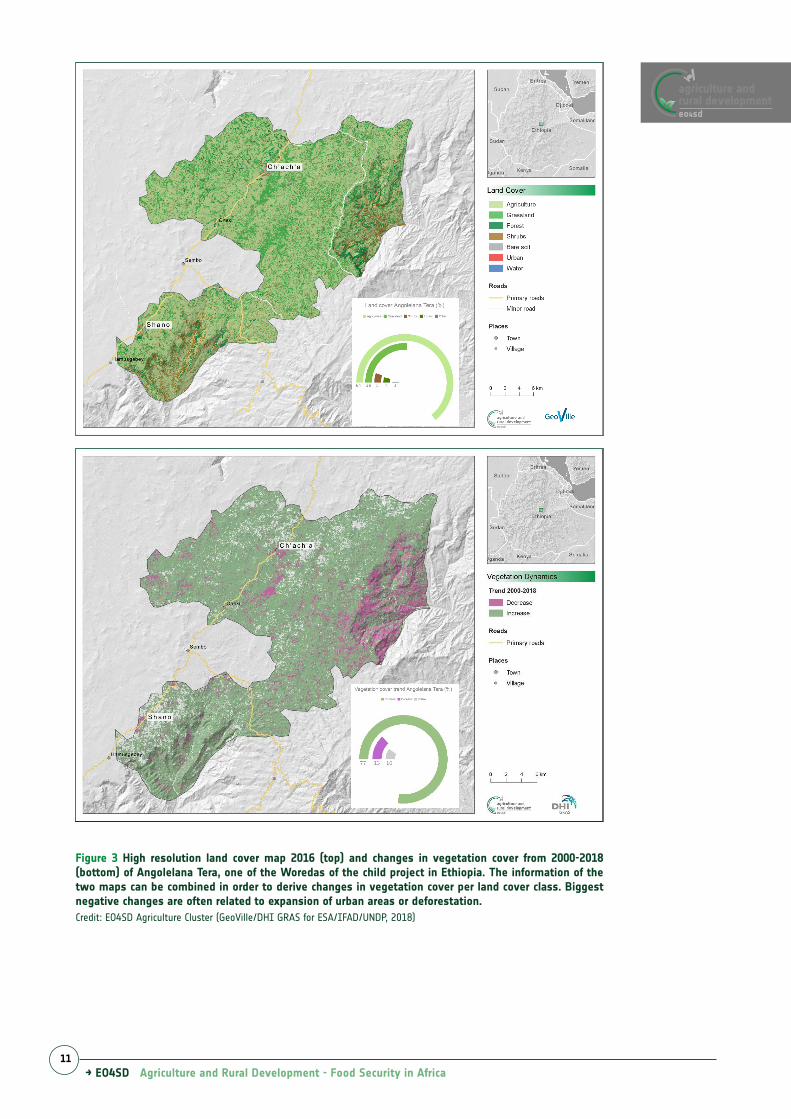
Figure 3 High resolution land cover map 2016 (top) and changes in vegetation cover from 2000-2018 (bottom) of Angolelana Tera, one of the Woredas of the child project in Ethiopia. The information of the two maps can be combined in order to derive changes in vegetation cover per land cover class. Biggest negative changes are often related to expansion of urban areas or deforestation.Credit: EO4SD Agriculture Cluster (GeoVille/DHI GRAS for ESA/IFAD/UNDP, 2018)
eo4sd
agriculture andrural development
→ EO4SD Agriculture and Rural Development - Food Security in Africa12
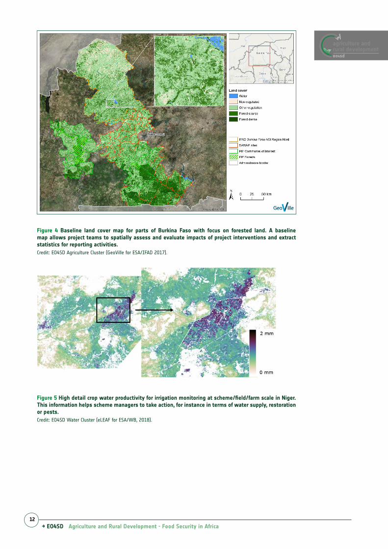
Figure 4 Baseline land cover map for parts of Burkina Faso with focus on forested land. A baseline map allows project teams to spatially assess and evaluate impacts of project interventions and extract statistics for reporting activities.Credit: EO4SD Agriculture Cluster (GeoVille for ESA/IFAD 2017).
Figure 5 High detail crop water productivity for irrigation monitoring at scheme/field/farm scale in Niger. This information helps scheme managers to take action, for instance in terms of water supply, restoration or pests.Credit: EO4SD Water Cluster (eLEAF for ESA/WB, 2018).
eo4sd
agriculture andrural development
→ EO4SD Agriculture and Rural Development - Food Security in Africa13
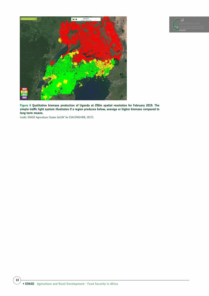
Figure 6 Qualitative biomass production of Uganda at 250m spatial resolution for February 2019. The simple traffic light system illustrates if a region produces below, average or higher biomass compared to long term means.Credit: EO4SD Agriculture Cluster (eLEAF for ESA/IFAD/WB, 2017).
eo4sd
agriculture andrural development
→ EO4SD Agriculture and Rural Development - Food Security in Africa14
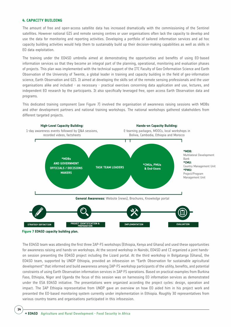
4. CAPACITY BUILDING
The amount of free and open-access satellite data has increased dramatically with the commissioning of the Sentinel satellites. However national GIS and remote sensing centres or user organisations often lack the capacity to develop and use the data for monitoring and reporting activities. Developing a portfolio of tailored information services and ad hoc capacity building activities would help them to sustainably build up their decision-making capabilities as well as skills in EO data exploitation.
The training under the EO4SD umbrella aimed at demonstrating the opportunities and benefits of using EO-based information services so that they become an integral part of the planning, operational, monitoring and evaluation phases of projects. This plan was implemented with the technical support of the ITC Faculty of Geo-Information Science and Earth Observation of the University of Twente, a global leader in training and capacity building in the field of geo-information science, Earth Observation and GIS. It aimed at developing the skills set of the remote sensing professionals and the user organisations alike and included - as necessary - practical exercises concerning data application and use, lectures, and independent EO research by the participants. It also specifically leveraged free, open access Earth Observation data and programs.
This dedicated training component (see Figure 7) involved the organisation of awareness raising sessions with MDBs and other development partners and national training workshops. The national workshops gathered stakeholders from different targeted projects.
The EO4SD team was attending the first three IAP-FS workshops (Ethiopia, Kenya and Ghana) and used these opportunities for awareness raising and hands-on workshops. At the second workshop in Nairobi, EO4SD and CI organized a joint hands-on session presenting the EO4SD project including the Lizard portal. At the third workshop in Bolgatanga (Ghana), the EO4SD team, supported by UNDP Ethiopia, provided an infosession on “Earth Observation for sustainable agricultural development” that informed and build awareness among IAP-FS workshop participants of the utility, benefits, and potential constraints of using Earth Observation information services in IAP FS operations. Based on practical examples from Burkina Faso, Ethiopia, Niger and Uganda the focus of this session was on harnessing EO information services as demonstrated under the ESA EO4SD initiative. The presentations were organized according the project cycles: design, operation and impact. The IAP Ethiopia representative from UNDP gave an overview on how EO aided him in his project work and presented the EO-based monitoring system currently under implementation in Ethiopia. Roughly 30 representatives from various country teams and organisations participated in this infosession.
Figure 7 EO4SD capacity building plan.
Hands-on Capacity Building:High-Level Capacity Building:1-day awareness events followed by Q&A sessions,
recorded videos, factsheetsE-learning packages, MOOCs, local workshops in
Bolivia, Cambodia, Ethiopia and Morocco
*MDBs
AND GOVERNMENT
OFFICIALS / DECISIONS
MAKERS
TASK TEAM LEADERS*CMUs, PMUs & End-Users
General Awareness: Website (news), Brochures, Knowledge portal
*MDB: Multilateral Development Bank *CMU: Country Management Unit*PMU: Project/Program Management Unit