33
1

1

2
European ATM Master Plan: Roadmap for the safe
integration of drones into all classes of airspace
Foreword ......................................................................................... 3
Introduction: The window of opportunity for Europe is now ........... 4
Vision for the safe integration of drones .......................................... 6
Operational and deployment view .................................................. 9
Business view ................................................................................. 19
Risk management .......................................................................... 24
Annex 1: U-space services .............................................................. 26
Annex 2: Drone capabilities for U-space ........................................ 29
Annex 3: Business view .................................................................. 30

3
Foreword Drones will be part of our future. Rapid changes in drone technology hold enormous promise for the
future use of airspace and aviation at large as the digital transformation expands skyward. This
requires a step-change in the way airspace is managed. Essentially, there will be a move from several
thousand conventional aircraft in the sky every day to potentially hundreds of thousands of highly
connected and automated aerial vehicles, offering advanced data-driven services and operating
everywhere, including in cities.
Transforming infrastructure to support such operations will be critical to harnessing the potential of
the sector, unlocking market growth, jobs and services to EU citizens. SESAR’s mission is to develop
an advanced aviation environment that supports the traffic growth for both manned and unmanned
aviation. Bringing together established aviation stakeholders and new players to rethink airspace and
scale up technologies is one of SESAR’s key challenges in preparation for this exciting new era.
Adaptation of our ways of working will not be sufficient, we also need to introduce a new approach
and this is where U-Space plays will play a central role in the future transformation of our skies.
This proposed contribution to the update of the European ATM Master Plan is an important
milestone on that path. It provides a bold vision for the safe integration of drones into all classes of
airspace and an ambitious rollout plan, ensuring that the energy of our community is channelled
towards clear priorities.
The drone race is on; let’s make it happen together.
Florian Guillermet
Executive Director
SESAR Joint Undertaking
4
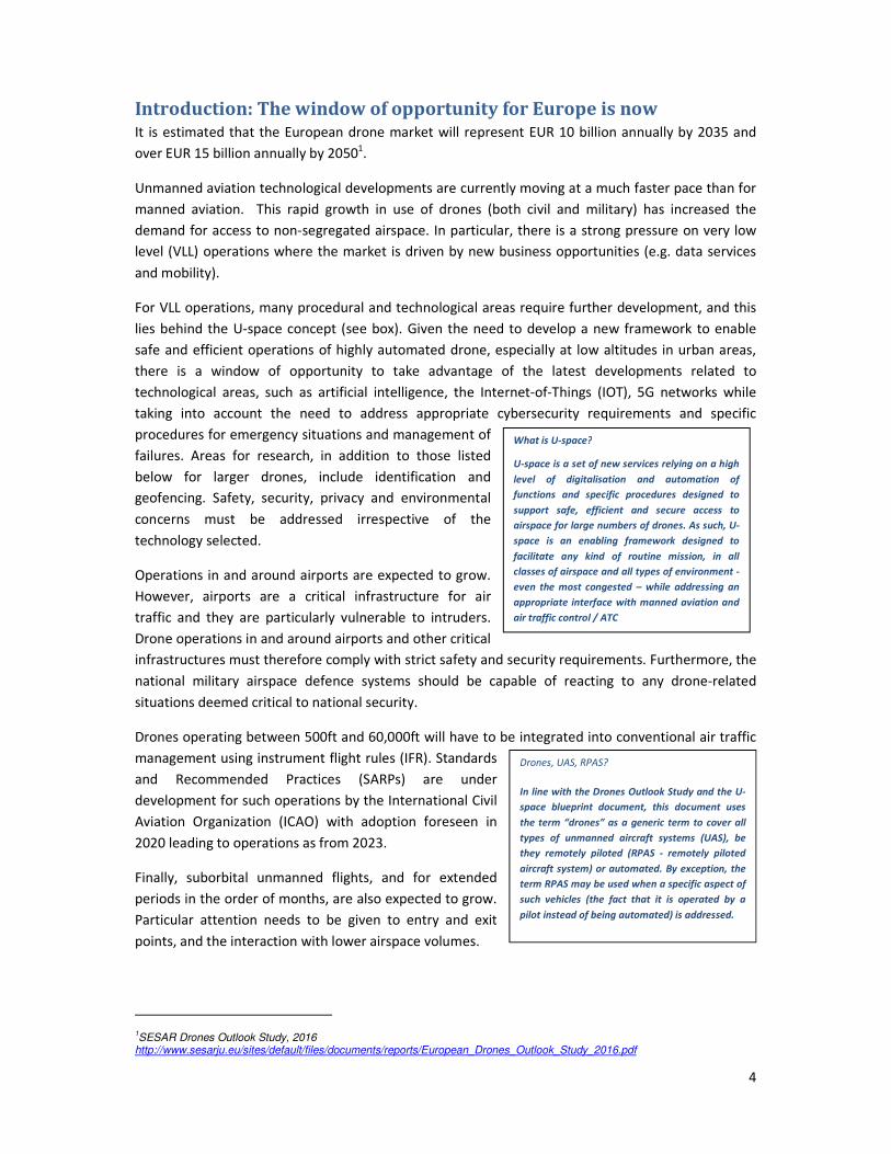
Drones, UAS, RPAS?
In line with the Drones Outlook Study and the U-
space blueprint document, this document uses
the term “drones” as a generic term to cover all
types of unmanned aircraft systems (UAS), be
they remotely piloted (RPAS - remotely piloted
aircraft system) or automated. By exception, the
term RPAS may be used when a specific aspect of
such vehicles (the fact that it is operated by a
pilot instead of being automated) is addressed.
What is U-space?
U-space is a set of new services relying on a high
level of digitalisation and automation of
functions and specific procedures designed to
support safe, efficient and secure access to
airspace for large numbers of drones. As such, U-
space is an enabling framework designed to
facilitate any kind of routine mission, in all
classes of airspace and all types of environment -
even the most congested – while addressing an
appropriate interface with manned aviation and
air traffic control / ATC
Introduction: The window of opportunity for Europe is now It is estimated that the European drone market will represent EUR 10 billion annually by 2035 and
over EUR 15 billion annually by 20501.
Unmanned aviation technological developments are currently moving at a much faster pace than for
manned aviation. This rapid growth in use of drones (both civil and military) has increased the
demand for access to non-segregated airspace. In particular, there is a strong pressure on very low
level (VLL) operations where the market is driven by new business opportunities (e.g. data services
and mobility).
For VLL operations, many procedural and technological areas require further development, and this
lies behind the U-space concept (see box). Given the need to develop a new framework to enable
safe and efficient operations of highly automated drone, especially at low altitudes in urban areas,
there is a window of opportunity to take advantage of the latest developments related to
technological areas, such as artificial intelligence, the Internet-of-Things (IOT), 5G networks while
taking into account the need to address appropriate cybersecurity requirements and specific
procedures for emergency situations and management of
failures. Areas for research, in addition to those listed
below for larger drones, include identification and
geofencing. Safety, security, privacy and environmental
concerns must be addressed irrespective of the
technology selected.
Operations in and around airports are expected to grow.
However, airports are a critical infrastructure for air
traffic and they are particularly vulnerable to intruders.
Drone operations in and around airports and other critical
infrastructures must therefore comply with strict safety and security requirements. Furthermore, the
national military airspace defence systems should be capable of reacting to any drone-related
situations deemed critical to national security.
Drones operating between 500ft and 60,000ft will have to be integrated into conventional air traffic
management using instrument flight rules (IFR). Standards
and Recommended Practices (SARPs) are under
development for such operations by the International Civil
Aviation Organization (ICAO) with adoption foreseen in
2020 leading to operations as from 2023.
Finally, suborbital unmanned flights, and for extended
periods in the order of months, are also expected to grow.
Particular attention needs to be given to entry and exit
points, and the interaction with lower airspace volumes.
1SESAR Drones Outlook Study, 2016
http://www.sesarju.eu/sites/default/files/documents/reports/European_Drones_Outlook_Study_2016.pdf

5
Establishing the right infrastructure to support drone operations and traffic growth for both manned
and unmanned aviation will be critical to harnessing the potential of the sector. Bringing together
established aviation stakeholders and new players to rethink airspace and scale up technologies is
one of SESAR’s key challenges.
This “Roadmap for the safe integration of drones into all classes of airspace” outlines which drone
related-research and development (R&D) activities should be prioritised in order to support the
expansion of the drone market and achieve the smooth, safe and fair integration of these new
aircraft systems into the European airspace. It also provides an ambitious rollout plan for these
technological developments.
It will be integrated in the 2018 Edition of the European ATM Master Plan as part of the update
campaign, paying particular attention to the refinement of the regulatory roadmap in the light of the
recent Helsinki declaration.
When integrated into the Master Plan, this roadmap will support the allocation of resources for the
development and the deployment of drone operations in all kinds of operational environments.

6
Vision for the safe integration of drones
The vision for drone integration is that drones (civil and military) will be completely and seamlessly
integrated into all environments and classes of airspace, operating safely and efficiently alongside
manned aircraft.
The vision is enabled by the establishment of a new framework, the U-space which, by design, relies
on high levels of automation and connectivity. U-space will support the management of safe and
efficient drone operations and address the proper interface with manned aviation and ATC. U-space
will take advantage of emerging technologies and will include automated functions in view of
enabling routine operations of large number of drones even in complex and dense areas, such as
cities. Over the time, automation and artificial intelligence (AI) will lead to the optimisation of drone
operations.
The vision also builds on the evolution of ATM towards the integration of large remotely-piloted
aircraft systems (RPAS) that will operate safely using ATM services: manned and unmanned will be
able to use the same airport infrastructure; they will both communicate with ATC using datalink;
rules and procedures will be applied to both with some adaptations for drones as the pilot is on the
ground.
Drone operations using U-space services will include leisure, commercial, and governmental
purposes, and will account for a majority of all drone flying hours. Operations using larger drones,
currently dominated by State and military operators, will expand including cargo and other civil
operations. These types of operations will imply changes to the relevant ICAO SARPS and will be
harmonised globally.
While large drones using ATM services are expected to be piloted remotely in a one to one
relationship, drones using U-space services will be highly automated and supervised. In U-space, the
flow of data is crucial and therefore depends on greater levels of connectivity.
By 2035, our skies will be at least ten times busier with a major part of flying hours performed by
drones operating beyond line of sight (BVLOS) in all environments using U-space to deliver a large
variety of services: inspection of critical infrastructure, deliveries, cargo freight, transport of people /
air urban mobility, precision agriculture, etc.
Airports operations will also evolve with an increased number of drones performing visual line of
sight (VLOS) platform inspections, flying in and out amongst single pilot aircraft or flying in the
vicinity of the airport, to transiting via pre-defined tracks or tactically managed route. Even in case of
mixed manned-unmanned operations, the drone and the manned aircraft is managed by either the
U-space traffic manager or conventional ATC.
Manned and unmanned traffic will operate safely and in harmony, including in non-controlled
airspace, especially rural environments thanks to established common rules ensuring fair access to
airspace. General aviation will fly jointly with drones in portions of airspace where they will provide
services for precision agriculture, deliver packages in remote areas, carry out search and rescue
missions, or execute preventive inspections of forest, high voltage lines and railways. The
environment will be mainly cooperative with an enhanced information-sharing system to allow
situation awareness at both strategic and tactical levels.

7
The high demand of access to airspace in urban areas will require the establishment of specific
requirements and procedures to ensure safety in the air but also protect people on the ground and
limit the impact of drone traffic on environment (emissions, noise, visual pollution). These operations
will rely on secure and robust communication systems which can cope with large number of
simultaneous operations as well as interference issues caused by large buildings. Drones operating in
urban areas will have to comply with reinforced requirements and abilities, including navigation
accuracy, management of failure and detect and avoid (DAA) capabilities. Drone operations will be
fully integrated with the concept of smart cities using innovative technologies and connectivity. In
these complex and dense areas, U-space will play a major role in managing the drone traffic and
ensuring the interface with all the actors involved in the broader drone ecosystem. As an example, U-
space will provide conflict-free trajectories to prevent an excessive reliance on on-board DAA. On the
other hand, operations of manned aviation will be safeguarded in these urban areas, in particular for
its high priority missions such as ambulance or security missions.
Flights above FL660 will also be integrated with entry and exit procedures through segregated or
non-segregated airspace. For example, high-altitude pseudo-satellites (HAPS) will be able to transit
and then fly at high altitudes to provide high-speed broadband communications.
At the same time, military will be fully integrated in the wider traffic situation except where mission
requirements demand otherwise. The integration of military medium-altitude long-endurance
(MALE) RPAS, will have paved the way for civil large RPAS operations in non-segregated airspace.
Work towards this vision will give an unprecedented impetus to the digitalisation, and automation of
the European ATM network. These are integral enablers to the SESAR vision to allow the efficient and
safe operation of both manned and unmanned systems in a shared airspace. In doing so, the
performance ambition of the European ATM Master Plan, in line with the Single European Sky High-
Level Goals, will not only be reached but may even be exceeded through the successful
implementation of disruptive technologies.
The evolution toward this target vision will be achieved through two complementary threads:
• An evolutionary thread, addressing the accommodation and integration of large certified2
remotely-piloted drones with manned aviation. These RPAS will interact with ATM in the
same way as manned aircraft, with special provisions designed to compensate for the fact
that the pilot is not on board the aircraft.
• An innovative thread, requiring the development of new U-space services and procedures to
provide airspace access to large numbers of typically smaller drones (mainly specific2),
supported by automation and connectivity.
Progress on both threads will be made in parallel, each benefiting from the results of research and
development (R&D) conducted on common areas of interest such as DAA, command and control
datalink or cybersecurity. This evolution will be supported by developments in standardisation and
regulation.
2 See EASA typology: https://www.easa.europa.eu/easa-and-you/civil-drones-rpas

8
Figure 1: the evolution of the target vision
Achieving the integration of drones will be an iterative process: as more services are deployed and
operations are enabled, drones will be progressively integrated into all classes of airspace until
reaching a point where full integration is achieved. Throughout this process, manned and unmanned
aviation will develop, with each sector benefitting from the technologies and evolutions of the other.

9
Operational and deployment view Large drones are expected to be remotely piloted with an identified operator and fly under
instrument flight rules (IFR) and an equivalent to visual flight rules (VFR)3 in the same manner as
manned aircraft.
The integration of hundreds of thousands of smaller leisure, commercial, or governmental drones
requires the creation of a new aviation concept: U-space.
These two threads that will evolve towards the full integration of all vehicles into the airspace;
technologies and procedures need to be developed accordingly.
3.1 Achieving RPAS integration with manned aviation
RPAS should be able to operate safely alongside manned aviation, respecting ICAO’s key principles4:
• In order to integrate seamlessly into the airspace, RPAS must, as far as possible, comply with
the operational procedures that exist for manned aircraft. Flight operations must not present
an undue hazard or burden to persons, property or other aircraft.
• RPAS operations must not degrade the current level of aviation safety or impair manned
aviation safety or efficiency. This applies equally to all operators and all drones.
• RPAS should conform to manned aircraft standards to the greatest extent possible. When
these principles are not achievable (due to unique RPAS designs or flight characteristics), and
no alternative means of compliance are identified, the operation of such RPAS may be
subject to safety risk mitigations, such as restricting operations to remain within segregated
airspace.
In order to achieve integration with manned aviation, a phased approach is envisaged:
• Phase 1: IFR RPAS in classes A-C: RPAS will be able to operate in airspace classes A-C under
IFR, with a DAA system that provides collision avoidance and situational awareness in
relation to cooperative traffic. RPAS will be able to communicate with ATC. Navigation and
surveillance equipage will be commensurate with the airspace in which the drone is
operating. Special provisions will be needed for ground operations at most airports.
Procedures and technology for dealing with contingency situations will be in place.
• Phase 2: IFR RPAS in classes A-G: RPAS flying under IFR will have a DAA capability, enabling
them to integrate with IFR and VFR traffic, both cooperative and non-cooperative, in airspace
classes A-G. Communications with ATC will use an appropriate architecture, addressing
integrity and security requirements.
• Phase 3: RPAS in classes A-G (IFR and VFR): RPAS will be able to operate in
controlled/uncontrolled airspace, both under IFR or VFR, and safely integrate with
cooperative and non-cooperative traffic. Increased use of datalink for ATC communications is
3 It is expected that technology will evolve and provide drones with capabilities allowing them to operate in a way similar to VFR.
4 ICAO RPAS CONOPS (March 2017)

10
likely. Work on broadening the range of drone types and mission continues, and the ATM
environment starts to evolve as routine operations diversify.
Phases 1 and 2 correspond to the ICAO “accommodation” period, while Phase 3 equates to the ICAO
“integration’ period. “Accommodation” refers to the condition when RPAS can operate along with
some level of adaptation or support that compensates for its inability to comply within existing
operational constructs. This may be necessary during normal operations, abnormal or problem
scenarios, and when emergency situations arise. “Integration” refers to a future when RPAS may be
expected to enter the airspace routinely without requiring special provisions.
Suitably-equipped RPAS can therefore “integrate” as soon as the aircraft and the supporting ATM
environment allow such integration. The “Integration” phase foresees a time when all European ATM
environments can support routine RPAS operations, but this does not prevent early adopters from
operating.
State RPAS will be integrated, operating as their civil counterparts except where operationally
necessary. Military requirements5 will be incorporated in the technical, operational and regulatory
domains. This will be enabled through the development of dual-use technology and the adoption of
common standards and procedures. Where State agencies have an operational need, they will be
given a level of priority commensurate with the operational need, as is now the case for manned
assets. Specific training needs will be met, where necessary, through airspace reservation, executed
under the provisions of advanced flexible use of airspace (AFUA).
3.2 Securing the development of U-space services
U-space is defined in the U-space blueprint document6 as a set of services designed to support safe,
efficient and secure access to airspace for large numbers of drones. These services rely on a high
level of digitalisation and automation of functions, whether they are airborne or part of the ground-
based environment. U-space provides an enabling framework to support routine drone operations,
as well as a clear and effective interface with manned aviation, ATM/ANS service providers and
authorities. U-space is therefore not a defined volume of airspace, segregated and designated for the
sole use of drones. Nonetheless, at early stages, there could be portions of reserved airspace to allow
for an earlier and incremental deployment of BVLOS operations, fostering the development of safe
and efficient traffic management for drones.
U-space will ensure the smooth operation of large numbers of small drones (mainly open or specific2)
in all operating environments, including in urban areas, and in all classes of airspace. It will support
all types of missions and concern all drone users7.
U-space architecture will be based on a federation of U-space service providers that can
cooperatively manage drone traffic in the same or/and adjacent geographical region, under a
regulatory framework ensuring the overall performance level and in particular its safety. U-space
5 In particular military Medium-Altitude Long-Endurance (MALE) RPAS will be integrated in non-segregated airspace through an
accommodation phase (2020-2025) and integration as IFR RPAS in classes A-C as from 2025.,
6 https://www.sesarju.eu/u-space-blueprint
7 Including commercial and leisure users as well as State (including military) and public entities with appropriate prioritisation for
special missions.
11
service providers will exchange information and coordinate themselves using interoperable
standards allowing for automated drone traffic management. It is expected that they will have a
certain level of qualification and appropriate oversight according to the criticality of the services they
do provide.
The progressive deployment of U-space is foreseen in an incremental manner: each new phase will
propose a new set of services while including an upgraded version of the services already existing
from the previous phase. The roll-out of each new phase should be seen as a high-level sequence for
EU-wide harmonisation, however implementations can be fast-tracked in parallel at local level and
for certain type of operations of lower risk and complexity. Over time, U-space services will evolve
and scale up as the level of automation of the drone increases, and advanced forms of interaction
with the environment are enabled (including manned and unmanned aircraft) mainly through digital
information exchanges.
U1 provides foundation services (e-registration, e-identification and pre-tactical geo-fencing) . The
main objectives of these services are to identify drones and operators and to inform operators about
known restricted areas. With the deployment of the U1 foundation services more drone operations
are enabled, especially in areas where the density of manned traffic is very low. The administrative
procedures for permission to fly and the authorisations for some specific missions will be facilitated.
The range of VLOS routine operations will be extended and will support extended VLOS flights,
including VLOS operations in an urban environment. BVLOS operations will still be constrained but
will become more and more possible.
U2 refers to an initial set of services that support the safe management of drone operations and a
first level of interface and connection with ATM/ATC and manned aviation. Where appropriate, U2
will make use of existing infrastructure from ATM, but new opportunities for drones operations will
be enabled through the exploitation of technologies from other sectors (e.g. long-term evolution -
LTE - for data communication). The range of operations at low levels will be increased, including
some operations in controlled airspace. Drone flights will no longer be necessarily considered on a
case-by-case basis, and some examples of BVLOS operations will become routine (albeit with some
constraints).
U3 will build on the experience gained in U2 and will unlock new and enhanced applications and
mission types in high density and high complexity areas. New technologies, automated DAA
functionalities and more reliable means of communication will enable a significant increase of
operations in all environments and will reinforce interfaces with ATM/ATC and manned aviation. This
is where the most significant growth of drone operations is expected to occur, especially in urban
areas, with the initiation of new types of operations, such as air urban mobility.

12
U4 focuses on services offering integrated interfaces with ATM/ATC and manned aviation and
supports the full operational capability of U-space based on a very high level of automation. It is
expected that the need for new services will arise during the roll-out of U3.
Figure 2: Initial operating capability (IOC) dates for the integration of RPAS with manned aviation and development of U-
space services at scale
3.3 Ensuring cybersecurity
The current ATM system consists of many bespoke systems and networks, often utilising national and
proprietary standards. It is clear that the future ATM system and U-space will rely on an increase in
interconnected systems based on novel technologies. Interoperability will be key in order to deliver
operational improvements through a shared view of all aeronautical information.
Two key concerns that threaten these benefits have been identified:
• Increased interconnectivity and integration creates new vulnerabilities to cyber-attacks, for
example through third-party access to ATM networks and systems.
• Interoperability implies an increased use of commercial-off-the-shelf (COTS) components
and, without careful planning, a corresponding loss of diversity. This increases the likelihood
of introducing common vulnerabilities into the system even if, by using open standards,
there is also a larger body of users who are actively finding and fixing vulnerabilities.
Not only should cybersecurity architecture be established at an early stage of U-space development,
number of guiding principles should also be defined for the organisational and technical measures
that are needed to strengthen cyber resilience, building on current cybersecurity best practices in the
information technology domain.
3.4 Ensuring optimal use and protection of aviation spectrum
To provide a safe and efficient global ATM system, internationally harmonised protected spectrum is
allocated to aviation. However, aeronautical spectrum allocations are and will continue to be under
13
significant pressure from other sectors and additional protected spectrum bandwith for use by
aviation is unlikely to be made available. It is therefore imperative to ensure an optimal use and
protection of the spectrum currently available for communications, surveillance and navigation
systems, and also to take advantage of the development of non-aviation-specific telecommunication
systems and infrastructure, such as 5G mobile networks and satellite communication where they
meet the needs.
3.5 Addressing safety and regulatory needs
Drones should be integrated into the aviation system in a safe and proportionate manner and this
integration should foster an innovative and competitive European drone industry, creating jobs and
growth, in particular for small and medium enterprises.
The regulatory framework, whose development has started under the auspices of EASA8, will set a
level of safety and of environmental protection, security and privacy that is acceptable to society. It
will offer enough flexibility for the drone industry to evolve, innovate and mature. The regulatory
framework will not simply transpose the system put in place for manned aviation, but will be
proportionate, progressive and risk-based. The rules must express objectives that will be
complemented by industry standards.
The further development of drones and their integration into non-segregated airspace will pose new
challenges for which a significant amount of further research needs to be performed.
As already identified by EASA9, the safety risks considered must take into account:
• Mid-air collision with manned aircraft;
• Harm to people;
• Damage to property in particular critical and sensitive infrastructure.
To reach these safety objectives, it is important to adopt an operation centric approach that includes
the aircraft, mission and operating environment10
. Appropriate combinations of requirements linked
to these three parameters should ensure reaching the requested level of safety.
One particular area of regulatory focus will be to review safety assessment and certification
requirements considering the change of the role of human in the overall system.
The future system will rely on a very high level of automation. Considering the wide disparity of
drone performance and reliability (ranging from toys to fully-certified platforms), it is extremely
important to ensure that aircraft operating in safety-critical environment incorporate appropriate
objective-based design requirements that contribute to the mitigation of the abovementioned risks.
Objective-based design requirements are closely linked to the operational environment and
procedures; e.g. the operation close to crowds could be acceptable when the drone has some
8 https://www.easa.europa.eu/easa-and-you/civil-drones-rpas
9 Stated in EASA’s Opinion: https://www.easa.europa.eu/document-library/opinions/opinion-technical-nature
10 This term includes also the airspace in which the drones flies and the overflown area

14
additional functionality (e.g. automatic loss of link procedures), and the competencies of the remote
pilot and the operational procedures are adequate. Industry standards will be needed to facilitate
demonstrating compliance to the objective-based design requirements.
In an era of rapidly changing technology, there is a need to be innovative and embrace new
regulatory tools inspired by other industries aiming at similar levels of automation, and create
conditions for Europe to develop strong testing/demonstration platforms and a showcase of EU
leadership on unmanned aviation.
Figure 2 depicts the regulatory approach, as well as the major regulatory activities that need to be
considered in order to ensure the safe, secure and environmentally-friendly integration of drones.
The principle of this approach is to implement an incremental regulatory baseline that is
synchronised with the deployment milestones and offers the possibility to learn from experience,
and adapt the regulatory tools taking advantage of the experience gained. The package numbering in
the figure is for illustration purposes only.
Figure 3: High-level regulatory cycle

15
Standardisation
Beyond the regulatory context, adequate standards will be critical to support the harmonised
implementation of concepts and technologies arising directly from industry.
The drone family represent a wide range of aircraft. It includes very large aircraft, which resemble
manned aircraft in size and complexity, but also very small consumer-electronics aircraft. All of these
categories are used in the same airspace as commercial air transport, general aviation, aerial work
and specific rotorcraft and military activities. Therefore, it is very important to ensure standards are
fit for purpose and are designed in a way that is commensurate with the type of drone, the type of
operation and the environment in which it will operate.
The bodies involved in the planning and development of drone-related standards have recently
agreed collectively to establish the European UAS Standards Coordination Group (EUSCG). The
EUSCG is a joint coordination and advisory group established to coordinate the UAS-related
standardisation activities across Europe, essentially stemming from EU regulations and EASA
rulemaking initiatives. The EUSCG provides a bridge between European activities in this domain and
those at international level. The main task of the EUSCG is to develop, monitor and maintain an
overarching European UAS standardisation rolling development plan, based on inputs from the
EUSCG members11
, while addressing the needs identified in the European ATM Master Plan. In that
meaning EUSCG will coordinate with EASCG in view of supporting a harmonised approach.
Figure 4 below represents the major standardisation activities that are required to enable the safe
integration of drones, some of which are already ongoing. For a matter of graphical representation,
the figure associates the EASA “certified” drone category to the conventional IFR/VFR domain
covered by RPAS, it also associates the “open” and ”specific” categories with the relative U-Space
domain. This does not prevent certified drones to operate under U-Space.
It should be noted that, to allow the market to expand, only those standards that are acknowledged
as absolutely necessary to secure safety and efficiency of drone operations and their insertion into
the airspace should be developed. Any other standards that may be needed to support market
growth will largely be developed by the industry itself, pioneers steering the developments of
industry-led standards without waiting for “hard regulation”. This will be likely to allow the market to
flourish faster and deliver benefits earlier. In addition, it may also be possible to adapt and use
existing standards from other relevant industries such as telecoms or autonomous land vehicles.
Basically, all possible efforts will be made to keep the standardisation cycle to its minimum, whilst of
course protecting safety and security.
11 The plenary membership of the EUSCG is composed of ASD, ASD-STAN, ASTM, DMAE, DAE, EASA, EUROCAE,
EUROCONTROL, The European Commission, EDA,CEN, CENELEC, ETSI , GUTMA, ISO,JARUS, SAE , SESAR JU, UVSI.

16
Figure 4: Standardisation needs
Operational and deployment roadmap
The European ATM Master Plan provides the high-level roadmap for the development and
deployment of capabilities and services supporting drone operations in a harmonised way across
Europe. Dates provided on the roadmap are aspirational and reflect the latest points in time at which
critical activities should be completed at a European scale. It is also clear that to harness the full
power of digital technologies for the sector, speed and a trial-and-error mind-set are needed. These
dates will therefore be regularly updated to reflect latest industry advancements as part of the
maintenance of the European ATM Master Plan.

17
Figure 5: The Deployment View
Global Harmonisation
The European vision of the safe and seamless integration of drones is carried out not in isolation but
in a global context. European efforts and initiatives to collaborate and coordinate at worldwide level
promote convergence of approaches, sharing of experiences and ultimately target global
interoperability for the integration of drones.
Cooperation between Europe and the US is achieved through the Memorandum of Cooperation on
civil aviation research and development, which includes a specific cooperation plan on UAS. In this
framework, the SESAR JU, the FAA and NASA aim to deliver a joint vision for safe integration of
drones in all classes of airspace, including U-space and UTM. This cooperation framework also allows
an exchange of views concerning common operational and deployment challenges, including the
standardisation and regulatory roadmaps.

18
At worldwide level, Europe is deeply involved in ICAO work on RPAS integration and the definition of
a common framework for UTM. The ICAO RPAS Panel has developed an RPAS CONOPS and work is
ongoing to identify the required updates to SARPs to allow IFR RPAS integration. In addition to this,
Europe also actively contributes to the ICAO UAS advisory group on UTM to ensure global
harmonisation.

19
Business view This Section provides an estimate of the investments required to support the safe and efficient
deployment of drones in Europe, in addition to the foreseen benefits arising from this future drone
ecosystem. Both benefits and investment levels are covered in detail, with the benefits drawn largely
from the previously released 2016 Drone Outlook Study12
, and the investment needs determined
through a high-level assessment, consolidating inputs from stakeholder groups, including: ANSPs,
innovative actors and start-ups, airspace users, drone operators, telecommunications and satellite
communications manufacturers, airport operators and the military.
The following should be noted regarding the assessments:
• The calculations are based on the initial roadmap of how ATM will develop to allow for the
safe deployment of drones, as defined by SESAR and refined throughout this exercise. They
are intended to act as a starting point for reflection by European decision makers.
• Throughout the document, the inputs have largely been developed through inputs from
stakeholders and SESAR hypotheses; as this field continues to evolve rapidly, it is possible
that the end-state may differ from the stance taken within this document
• Only investments associated with ATM, covering both RPAS integration and U-space
implementation, are considered and reported; benefits include all of those indicated in the
2016 Drone Outlook Study and the impact of urban air mobility
• This work will be leveraged to support further developments for a more concrete and holistic
view in the future.
4.1 Overview of benefits and investment levels
European demand within the drone marketplace is valued at in excess of EUR 10 billion annually13
, in
nominal terms, leading to a cumulative benefit of over EUR 140 billion by 203514
. Civil missions for
government purposes and commercial businesses are expected to generate the majority of this value
on the basis of multi-billion product and service industries. Defence and leisure industries will
continue to contribute to this marketplace and remain a source of high value in the near-term,
representing together nearly EUR 2 billion in annual product-related turnover for the industry over
the long term.15
The minimum infrastructure investment required to ensure safety and unlock the value at stake for
Europe is attainable through relatively low investments, leveraging existing infrastructure and
scaling-up through investments in automated and smart systems. The assessment has identified key
investments by stakeholders amounting to nearly EUR 4.5 billion by 2035 (Figure 6).
12 The 2016 Drone Outlook Study can be found on the SESAR website
13 2016 Drone Outlook Study, Section 4.2 of this document (covering urban air mobility addition)
14 Composed of commercial, governmental, and leisure drones (excluding defence)
15 Although the 2016 Drone Outlook Study assessed the economic impact for defence, as noted above, these figures have been excluded
from the overall benefits illustrated throughout this document, as limited data was available on the investment needs and therefore
illustrating full benefits without full anticipated investments was deemed misleading to represent.

20
Figure 6: Overview of investment associated to the safe integration of drones and benefit levels16
The investment in U-space should be viewed as critical to unlocking the future potential benefits
from the drone ecosystem, accounting for >85% of the anticipated benefit by 2035.
4.2 Review of the economic and societal benefits identified in the 2016 Drone Outlook Study
An economic impact analysis of the entire value chain for each demand area revealed the yearly
potential for a European market would exceed EUR 10 billion by 2035 and would further grow to
approximately EUR 15 billion by 2050. A market of this size will also drive new job creation
throughout all Member States, as each will need localised operations, pilots, maintenance
contractors and insurers among other specific occupations. In short, over 100 000 direct jobs are
expected to be generated by this significant market17
, in addition to many other indirect benefits.
In addition to the aforementioned benefits, the business assessment also takes into account benefits
stemming from the growth and adoption of urban air mobility18
. It is envisaged that this form of
mobility will result in market value of at least EUR 2 billion annually by 2031 with a market take-off in
202719
. The value is calculated by estimating adoption across the following three use cases:
1. City to airport travel – based on actual airport passengers and price sensitivity analysis;
2. Taxi use – based on actual origin-destination figures, focusing on long-distance trunk routes;
3. Commuting – typically high volume routes.
Volumes were determined by considering 25-30 European cities among an initial assessment based
on the 130 largest cities worldwide.
The annual economic value across the indicated landscapes has been summarised in Figure 7.
16 Source: 2016 Drone Outlook Study; SESAR and stakeholder assessments. Investments cover only changes related to the safe integration of
drones. In order to realise the benefits, additional investments that are not safety-related will have to be made by stakeholders but are not
accounted for here (e.g. investments related to commercial service delivery).
17 Based on data by the Organisation for Economic Cooperation and Development (OECD)
18 Urban Air Mobility refers to an envisaged future state where people and/or goods can be transported around densely populated urban
areas within very short timeframes, leveraging airspace to do this.
19 Urban Air Mobility figures based on an assessment performed by BCG in collaboration with Airbus. This assessment was completed with a
view through 2032. To extend the work through 2050, traffic volumes and benefits were assumed constant after 2032. Although additional
growth is likely, further assessment was outside the scope of this business review and not completed given time and resource constraints.

21
Figure 7: Economic benefits of drone deployment in Europe (undiscounted)20
4.3 Investment level assessment
This assessment aims to identify the required investments related to ATM for the safe and efficient
integration of drones into European airspace. These are based on a number of assumptions that
carry significant uncertainty. As a result, the overall investment figures should be interpreted in
terms of their order of magnitude only. In order to increase the validity of assumptions used in
calculating the investment levels, stakeholder bilateral meetings were conducted with experts, in
addition to an investment survey. The assessment does not represent any specific organisation or
stakeholder, but rather represents a consolidation of available industry input, including that of
SESAR. This work serves as a reference to build upon and further substantiate in the future. A list of
key underlying investment assumptions are provided in Annex 3.
The anticipated investments have been structured into three categories: Infrastructure and services,
airborne investments and human resources. Investment levels associated to each category and sub-
category are provided below, in addition to a deployment view showing investments over time.
20 Source: 2016 Drone Outlook Study; Urban Air Mobility input from external BCG project in collaboration with Airbus

22
Figure 8: Breakdown of investment level by category and associated with each phase21
Figure 9: Investment needs of drone deployment in Europe (undiscounted)
For each identified investment sub-category, a high-level assessment and assumption base were
developed to provide a view on the potential investment level for stakeholders. The split between
the assessment and associated stakeholder is expected to evolve as the drone ecosystem maturity
level increases. To facilitate this exercise, primary, secondary, and tertiary stakeholders were
identified for each investment category and high-level assumptions drove a percentage split across
the stakeholders. This assessment should not be interpreted as exhaustive or final, but rather as a
directional view to be further refined.
Figure 10: Preliminary stakeholder investment breakdown
U-space service providers and drone operators are expected to invest the most across stakeholder
groups. For U-space service providers, this is driven by the investments required to support new
21 Investment associated to a particular phase, regardless of the point in time the investment occurs (e.g. investment to support all U3
services, regardless of whether investment started in U2)

23
services in the ecosystem, while large investments for drone operators are required to ensure the
drones are appropriately equipped to enable the required services. The scale of operations and
growth in drones are expected to grow substantially, making the associated investment meaningful
(the specific category fleet size will evolve from under 10 000 drones in 2015 to nearly 400 000
drones in 205022
). The Military is not listed per se since this stakeholder is not integrated into the
various roles, i.e. airspace user, ANSP, airport operator and drone operator. Stakeholder inputs on
required military investments (air and ground) were not fully available at the time of publication. A
standalone assessment of available military data indicates that partial investment levels are in the
order of EUR ~400 million.23
4.4 The ATM business model and the need for incentivisation
Given the dependency of drone deployment on new technologies, new interfaces, new sets of
services and new service providers, business models with limited presence in current ATM are likely
to emerge to support this ecosystem, particularly for U-space. It is not the role of the Master Plan to
define these business models, but it is clear that viable models must be developed in order to
support the investments and realise future benefits. Other industries provide a glimpse into the
potential models available, such as fee-based or software as a service (SaaS) models, where drone
operators may receive basic services free of charge, but require higher investment for more
advanced needs, scaled operations or higher service levels.
As development of the landscape is still at an early stage, both from technological readiness and
operational perspectives, substantial risk exist for first movers and early investors. Industry must
ensure that the commercialisation can be realised and scaled up; industry must recognise this risk
and take measures to ensure the necessary resources are available to make these critical
investments – without them, the pace of evolution will slow and the vast value at stake will not fully
materialise. In addition, given the dependencies described above, coordination at European level
should help ensure that investment levels are kept as low as possible and that benefits are fully
realised. More broadly, a robust incentivisation strategy will de-risk the deployment, maximising the
opportunity for benefits across all stakeholders.
22 A summary of drone fleet size evolution can be found in the Appendix
23 Unit level airborne investment for certified drones were used as a proxy and applied to the anticipated military drone fleet. Ground
investments for airport adaptations and ATC interface requirements, were applied to 10 military air bases in Europe. Additional investments
may be required and this assessment will be updated as more data becomes available.

24
Risk management This Section addresses the most significant risks associated with the realisation of the vision for the
safe integration of drones. Determining risks does not imply that they will actually materialise, rather
that these risks have been identified and are adequately managed so that they do not impact the
delivery of the Master Plan.
By necessity, risk management is an ongoing process in which regular monitoring is required of the
status of ongoing mitigation actions.
Table 1 - Identified high-priority risks
Risk description Impact/Consequences Mitigation actions
The necessary
investments for R&D
activities related to the
safe integration of
drones are not secured
• Delay in the development of
critical solutions and
standards
• Limited development of the
drone EU market.
By: EC, SJU
• Ensure that SESAR work
programme covers necessary
R&D.
• Secure participation from
innovative players, new entrants
• Secure adequate funding for next
multiannual financial framework
(MFF)
Global harmonisation
of the regulatory
framework for drone
operations is not
ensured
• Re-alignment with
international regulation will
cause delays in deployment
and increase costs.
By: EC, EASA, SJU
• Ensure EU presence in global fora
dealing with drones.
• EU collaboration with other
regions (e.g. US, Asia).
Standardisation and
regulatory needs are
not sufficiently
addressed and
delivered on time,
resulting in delays in U-
space deployment
• Economic and societal
benefits not realised at the
expected level.
By: EC, SJU, EASA, standardisation
bodies
• Strengthen cooperation with
standardisation bodies to ensure
alignment of their respective
work programmes with the needs
identified in the Master Plan.
• Strengthen engagement of the
regulatory authorities in the
development phase to prepare
for deployment.
Incidents and/or
accidents involving
drones and manned
aviation
• While serious incidents or
accidents are likely to be very
infrequent, they may have
very serious consequences;
even a trickle of low impact
incidents will erode trust in
the safety of drone
operations and could delay
their integration and the
associated benefits.
By: EASA and Member States
Regulator/NAA:
• To accelerate the development of
rules and means of compliance
(incl. harmonised U-space
services)
• To establish a timely set of rules
around minimum training
requirements.
Requirements linked to
societal expectations
such as environment,
• Delay in the deployment of
U-space services resulting in
lost business opportunities
By: EC, SJU
• Ensure participation of relevant
European Commission
25
privacy and security
are not properly
addressed in
developing U-Space
and negative impacts on EU
citizens
Directorate Generals (e.g. DG
HOME) when developing U-
space

26
Annex 1: U-space services U-space is a set of new services which will be deployed in an incremental manner: each new step will
propose a new set of services while including an enhanced version of the services already existing.
This annex proposes an indicative description of services, for which the detailed definition and the
applicable environments are the subject of ongoing research and development.
U1 – U-space foundation services
E-registration
The service enables the registration of the operator, drone and pilot with the appropriate
information according to Regulation. A level of security of the service will be defined.
E-identification
The service allows the identification of a drone operator from a drone in operation (in line with the
global scope of registry (ICAO) & eIDAS - Regulation (EU) No 910/2014). The identification provides
access to the information stored in the registry based on an identifier emitted electronically by the
drone. The identification service includes the localisation of the drones (position and time stamp).
Pre-tactical geofencing
The service provides the operator with geo-information about predefined restricted areas (prisons,
etc.) and available aeronautical information (NOTAM, AIRAC cycle) used during the flight
preparation.
This service requires the identification of accredited sources and the availability of qualified geo-
information related to restricted areas.
This service provides information that allows the drone operator to make use of the geofencing
capability of the drone.
U2 – U-space initial services
Tactical geofencing
Compared to U1 pre-tactical geofencing, tactical geofencing brings the possibility to update the
operator with geofencing information even during the flight.
Tracking
This refers to the service provider using cooperative and non-cooperative surveillance data to
maintain track-identity of individual drones. The capability includes ground and air surveillance
systems, as well as surveillance data processing systems.
The performance requirements of the capability will vary in accordance with the specific
requirements of each application.
Flight planning management
This service covers the receipt of a flight notification or a flight plan and provides the appropriate
answer according to the characteristics of the mission and applicable regulations
This service will be available for any drone operator/user with different levels of requirements.
Weather information

27
The service provides drone operators with forecast and actual weather information either before or
during the flight; it can also collect and make available weather information from different
stakeholders.
Different levels of service provision could be considered; for example:
- MET information for missions in a rural environment (based on existing aeronautical
information);
- Enhanced weather information for missions in urban areas;
- Micro-weather information for urban areas (urban canyoning/ autonomous vehicles)
Drone aeronautical information management.
This service provides the operator with relevant aeronautical information for drone operations. It will
connect to the Aeronautical information service (AIS) to guarantee coherent information provision
for manned and unmanned operators.
Procedural interface with ATC
The service is a set of defined procedures for some mission types where there may be an impact on
ATC; for example crossing certain types of controlled airspace under prescribed conditions. The
procedures ensure clear and unambiguous drone operation, and provide an appropriate flow of
information between the drone operators and ATC. Such procedures will allow drones to fly in
controlled airspace and near airports with more flexibility and procedural approval/rejection based
on agreed rules.
Emergency management
The service receives emergency alerts from operators (e.g. loss of control), and informs relevant
actors of the ecosystem. These may include drone operators operating drones nearby, ANSPs, police,
airport authorities. The service also provides the drone/operator with assistance information to
manage the emergency situation (e.g. location of landing pads).
Strategic deconfliction
The service provides deconfliction assistance to a drone operator at strategic level (when the flight
plan is submitted, it is compared to other known flight plans and a deconfliction in time or route
could be proposed). This service could be mandatory or optional according to the operating
environment.
Monitoring
Subject to appropriate data-quality requirements, this service retrieves data from the tracking
service and fuses it with information related to non-cooperative obstacles and vehicles in order to
create air situation for authorities, service providers, and operators. This service may include
conformance monitoring.
Traffic information
This service provides the drone operator with traffic information coming from any kind of monitoring
services.

28
U3 – U-space advanced services
Dynamic geofencing
Compared to tactical geofencing in U2, the dynamic geofencing targets the drone itself and then this
service requires data-link connectivity to a geofencing system that allows the data to be updated
during the flight.
Collaborative interface with ATC
The service provides a mechanism to ensure proper effective coordination when drone operations
using U-space services impact ATC. It encompasses shared situational awareness and procedures to
enable a two-way dialogue supporting the safe and flexible operation of drones in airspace where
ANS are provided.
Tactical deconfliction
This service provides information to the operators or the drones to ensure separation management
when flying. The differences with the strategic deconfliction described in U2 are twofold: the drone
may receive the information and this deconfliction is set for the in-flight phase. It will be necessary to
appropriately define the boundaries with the use of Detect & Avoid capabilities.
Dynamic capacity management
Upon the definition of drone density thresholds (that can be dynamically modified), the service
monitors demand for airspace, and manages access to that airspace as new flight notifications are
received. This service may be coupled with the flight planning management service. There should be
appropriate set of rules and priorities for slot allocation when a portion of airspace is expected to
reach its capacity limits. Apart from the demand and capacity balancing, the service could manage
capacity due to non-nominal occurrences, such as weather hazards or emergency situations.
U4 – U-space full services
U4 offers the full integration with manned aviation and air traffic services and supports the full
operational capability of U-space based on a very high level of automation. It is expected that the
need for new services will arise during the roll-out of U3. In addition, it is envisaged that manned
aircraft could be equipped to take advantage of U-space services.
Annex 2 below describes the capabilities that will be needed to support the implementation of U-
space services. The ‘Phase’ column describes the initial U-space deployment phase where each
capability will be required. As new phases are entered, and new and more advanced U-space services
become available, the specification of many capabilities will become more demanding. Moreover,
the specification of the capability requirements may change with the mission environment (Urban,
sub-urban, rural).

29
Annex 2: Drone capabilities for U-space As the range of mission types expands, and U-space services are deployed and enhanced, drones of
all types, and the supporting ground infrastructure, will need to have capabilities that evolve
accordingly. Table 2 below show the capabilities expected to enable U-space services.
Capability Actor Description Phase
e-Identification Drone, drone
operator, service
provider
Ability to identify the drone and its operator in the U-space system U1
Geofencing Drone, drone
operator, service
provider
Ability to comply with geographical, altitude and time restrictions defined by the
geofencing service. This capability covers the technology, processing and any
required communication links, as well as management and use of geofencing
information used in the provision of this service.
U1
Security Drone, drone
operator, service
provider
Ability to protect vehicle and data (interaction with other vehicles and
infrastructure) against attacks on information technology and communications
systems.
U1
Telemetry Drone Ability to transmit measurement data from the drone-to-drone operator and/or
service provider to meet the demands of relevant services.
U1
Tracking Drone, drone
operator, service
provider
Ability of the drone to provide flight parameters including at least its position and
height.
U1/U2
Vehicle to
Vehicle
communication
(V2V)
Drone Ability for drones to communicate information to each other. The nature of the
information exchanged, and its performance requirements, will depend on the
application.
U3
Vehicle to
Infrastructure
communication
(V2I)
Drone, drone
operator, service
provider
Ability for drones to share information with infrastructure components. U3
Communication,
Navigation and
Surveillance
Drone, drone
operator, service
provider
Ability for drones to meet the communication, navigation and surveillance
performance requirements for the specific environment in which they will operate.
This capability involves the combination of on-board sensors and equipment (e.g.
data link, voice radio relay, transponder, laser, GNSS, cellular etc.) as means of
achieving the required performance.
U1
Detect and
Avoid
Drone Ability for drones to detect cooperative and non-cooperative conflicting traffic, or
other hazards, and take the appropriate action to comply with the applicable rules
of flight. This includes the collision avoidance, situational awareness and “remain
well clear functionalities, as well as the other hazards described in chapter 10.2.3 of
the ICAO RPAS Manual: terrain and obstacles, hazardous meteorological conditions,
ground operations and other airborne hazards.
U3
Emergency
Recovery
Drone Ability of drones to take account of failure modes, such as command and control
(C2) link failure, and take measures to ensure the safety of the vehicle, other
vehicles and people and property on the ground. This includes identification of
possible problems (auto-diagnostic) and all equipment required to manage
solutions.
U1/U2
Command and
control
Drone, drone
operator
Ability of drones to communicate with their ground control station to manage the
conduct of the flight, normally via a specific data link.
U1
Operations
management
Drone operator,
service provider
Ability to plan and manage drone missions. This includes access to and use of all
aeronautical, meteorological and other relevant information to plan, notify and
operate a mission.
U1
Table 2: Drone capabilities for U-space

30
Annex 3: Business view Table 3: Primary investment requirements
Category Sub-category Description and/or example
Ground
infrastructure
ATC interface and
airport adaptations
This includes both enhancements for current ATM/ATC systems to ensure
processing the necessary data and adaptations for U-space infrastructure
to support this interface. A potential requirement may be for investments
in adaptations (e.g. a more robust set network of sensors) to ensure
surface procedures operate efficiently.
Drone traffic
management (DTM)
The DTM system encompasses the functionalities and services attached to
the safe and efficient management of drone flights (e.g. flight planning
management, assistance for deconfliction, as well as requirements linked
to the cybersecurity and the communication with other actors in the
ecosystem). This may require investments related to ground and/or
cloud-based servers, computers, software, and facilities.
Protection sensitive
sites
Critical infrastructures (e.g. airports, government buildings, power plants),
may need hardware (e.g. radar, counter drones) to protect from intrusion
of non-cooperative drones.
Telecommunications &
satellite communications
Enhancements, reconfiguration to existing telecom networks and
deployment of shared low earth orbite (LEO) satellite constellation to
support full-scale deployment
Geo-fencing database
A continuously updated repository of airspace restrictions must be fully
developed and accessible to ensure no-fly zones and other restrictions are
respected.
Enhanced data provision
and information sharing
The term "enhanced data provision and information sharing" refers to
three topics: (1) the provision of drone-specific aeronautical information
(2) enhanced weather capabilities (to provide more specific
meteorological), (3) real-time information sharing between all actors of
the ecosystem.
Drone traffic
management oversight
DTM oversight at the EU level would leverage access to an overarching
view of traffic and activity of the different certified DTM service providers
to, among other tasks, support capacity management and assist in service
provider coordination.
e-registration and
e-identification
Drones will be required to register, and accordingly, this information
needs to be stored and managed in a secure way. In addition, drones are
expected to broadcast their identifier so that they can be identified by
accredited entities.
Airborne
infrastructure
On-drone capabilities
To enable the services associated with the various stages of U-space &
RPAS, hardware and software capabilities will be required. This
investment sub-category covers the incremental requirement of
equipping the drone with this hardware and software to enable each

31
service.
On other aircraft
capabilities
Although expected to be minimal, hardware and software may be
required on the current and future civil fleets.
Human
resources
Procedure development Procedures will need to be developed in order to support the interfaces
and services across U-space and ATM.
ATC personnel training
Training will be required for personnel in order to adapt to new processes,
procedures, and interfaces accommodating the increasing number of
drones mixed with manned aviation that will use the traditional ATC
services.
Table 4: Consolidated assumptions driving stakeholders’ share of investment
Stakeholder Key assumptions
U-space service
providers
• 100 % investment in DTM, DTM oversight, geo-fencing, enhanced data
provision and information sharing, and e-registration/e-identification
infrastructure requirements noted within this assessment. In some cases
for e-registration/e-identification there may be national government
involvement, which is not accounted for in this early assessment.
• 50 % investment in infrastructure requirements related to the Interface
with ATC, shared with ANSP stakeholders;
• ~50 % investment in procedure development investment; the percentage
of investment level for procedure development is split across U-space
service providers, drone operators, and ANSPs, based on the stakeholder
split of investment required for ground and air infrastructure.
Drone operators
• 100 % in drone investment requirements and ~35 % in procedure
development investment levels; the percentage of investment level for
procedure development is split across U-space service providers, drone
operators, and ANSPs, based on the stakeholder split of investment
required for ground and air infrastructure.
ANSPs
• 50 % investment related to ATC interfacing, shared with U-space service
providers;
• 100 % investment for ATC personnel training and ~15 % of procedure
development investments; the percentage of investment level for
procedure development is split across U-space service providers, drone
operators, and ANSPs, based on the stakeholder split of investment
required for ground and air infrastructure..
Telecom & Satcom
provider
• 100% of required infrastructure investment to support telecom/ satellite
communications enhancements
Others
• Investments will be required by public and private entities to support
protection of sensitive sites (e.g. government buildings, power supply,
transportation systems, etc.)
Airport operators • 100% investment in airport adaptation investments, including protecting
these airports as sensitive sites
Airspace users • 100% of required investment for equipage on non-drone aircraft.

32
Table 5: Summary of drone & conventional air fleet volumes
Summary – Drone & Conventional Fleet Sizes (000s)24
2015 2018 2020 2025 2030 2035 2040 2045 2050
Open category 1,000 5,000 6,000 7,000 7,000 7,000 7,000 7,000 7,000
Certified category (excl.
Military) - - - - - - 2 6 13
Specific category 9 45 86 200 373 386 384 390 396
Military 1 1 1 1 1 2 2 2 3
Urban air mobility - - - - 2 4 4 4 4
Scheduled airline fleet 11 12 13 15 17 20 22 25 25
Business aviation fleet 7 7 8 8 8 9 8 7 4
Rotorcraft fleet 2 2 2 3 3 3 3 2 1
VFR 59 61 63 67 71 75 79 83 87
IFR 13 14 15 17 20 22 25 27 29
Key underlying investment assumptions supporting Section 4.325
• The focus of effort was to determine the minimum ATM-related infrastructure investment
required to support a safe drone ecosystem in Europe. In scope investments include: ground
and airborne infrastructure investments and select human resources directly related to
deployment and safety. Out of scope elements include, but are not limited to: operating
costs, investments to develop and establish U-space services, drone design and certification
investment, and insurance related costs.
• The timeframe for the business view is 2018-2050, with most figures and tables depicting the
timeframe to 2035, by which time the majority of investment (~70%) is anticipated to have
been spent. Figures referring to 2035 (or any other annual figure) investments include those
required for future phases, while figures referring to a phase (e.g. U3) include all investments
associated to that phase, regardless of timing.
• Other relevant sectors (e.g. connected cars, advanced metering infrastructure, etc.) are
assumed to allow for meaningful comparisons to the drone landscape in particular areas.
Where appropriate, they are leveraged as proxies to support assumptions.
• Drone volumes materialise as foreseen in the Drone Outlook Study, with all inherent
assumptions.
• Open, specific, and certified drone categories, as defined in the Drone Outlook Study, are
within scope; It is assumed that open category drones are impacted by e-registration, e-
identification, and tracking requirements only on the basis of likely safety regulations.
• A combination of published V2V module investment decline data and drone price evolution
input were used to determine an experience curve, applied to decrease on-drone
investments over time.
• Investments start in 2018 for U1 and are made either in the preparation of a new phase or
when a new step starts depending on the operational and technical needs.
• For this assessment, it is assumed that the U-space will follow a federated model in Europe
given the necessity for highly automated systems to handle the anticipated scale of
24 Source: 2016 Drone Outlook Study model
25 Based on SJU & working group input

33
operations; a volume of 15 certified drone traffic management (DTM) providers is assumed
for Europe.
• Existing communication infrastructure will be leveraged and no dedicated communication
layer is required; similarly, a new satellite constellation that would be shared both with non-
European users and for non-drone applications (e.g. connected trains) is envisaged.
• Airborne investment requirements for urban air mobility are included, but due to lack of
available data at time of publishing, airport modification and landing pad investments to
accommodate this are not included.
• It is assumed that ground infrastructure solutions include facility, build-out, and necessary
hardware and software to serve the indicated function; the actual end-state solution could
also be cloud-based or hybrid, however, this is not accounted for in this assessment.
• The evolution of the drone ecosystem will materialise with minimal impact on civil aviation
fleets; however, it is foreseen some equipment for general aviation may be needed to
accommodate the safe operation of drones in uncontrolled airspace.
Figure 11: Ground investment levels over time
Figure 12: Airborne investment levels over time


