1 Evaluation of a Berth Sedimentation Control Technology in the Kill Van Kull: The AirGuard™ Pneumatic Barrier System John E. Chapman, P.E. * and W. Scott Douglas ** * Project Manager, Ocean and Coastal Consultants, Inc., 35 CorporateDrive, Trumbull, CT 06611 (203)268-5007; [email protected]** Dredging Program Manager, NJ Department of Transportation, Office of Maritime Resources, P.O. Box 837, Trenton, NJ 08625; [email protected]The problems associated with dredging and disposal in the New York and New Jersey Harbor area over the past 10 years have triggered sedimentation avoidance as being one of many possible tools in an ever-growing arsenal of dredged material management technologies. With overall project costs associated with the permitting, dredging, transportation, and disposal of dredged material reaching a typical value of $50 per cubic yard in the harbor, it is apparent to many that technologies which can reduce sedimentation within a berth are worthy to pursue. This paper discusses the results of a two year program which examined the effectiveness of a pneumatic control system to reduce or eliminate accretion of sediments within an active barge berth. Sold under the trade name AirGuard™, this system was installed at a pier berth on the Kill Van Kull in Bayonne, New Jersey. Owned and operated by IMTT-Bayonne, the pier berth was dredged in early 1998, and the system was subsequently installed in 1999. The objective of the study was to evaluate environmental and hydrographic data data between adjacent berths and to develop a cost-benefit ratio for users to apply when considering this technology for other sites. Over the course of the study period, hydrographic surveys, water quality studies, and fish surveys were performed to evaluate the effectiveness and potential environmental impacts of the system. Results indicate that Air Guard™ can be used to reduce dredging requirements in pier berth areas in an economically and environmentally sound manner.
Transcript
1
Evaluation of a Berth Sedimentation Control Technology in the Kill Van Kull: The AirGuard™ Pneumatic Barrier System
John E. Chapman, P.E.* and W. Scott Douglas**
* Project Manager, Ocean and Coastal Consultants, Inc., 35 CorporateDrive, Trumbull, CT 06611 (203)268-5007; [email protected] **Dredging Program Manager, NJ Department of Transportation, Office of Maritime Resources, P.O. Box 837, Trenton, NJ 08625; [email protected]
The problems associated with dredging and disposal in the New York and New Jersey Harbor
area over the past 10 years have triggered sedimentation avoidance as being one of many
possible tools in an ever-growing arsenal of dredged material management technologies. With
overall project costs associated with the permitting, dredging, transportation, and disposal of
dredged material reaching a typical value of $50 per cubic yard in the harbor, it is apparent to
many that technologies which can reduce sedimentation within a berth are worthy to pursue.
This paper discusses the results of a two year program which examined the effectiveness of a
pneumatic control system to reduce or eliminate accretion of sediments within an active barge
berth. Sold under the trade name AirGuard™, this system was installed at a pier berth on the
Kill Van Kull in Bayonne, New Jersey. Owned and operated by IMTT-Bayonne, the pier berth
was dredged in early 1998, and the system was subsequently installed in 1999. The objective of
the study was to evaluate environmental and hydrographic data data between adjacent berths and
to develop a cost-benefit ratio for users to apply when considering this technology for other sites.
Over the course of the study period, hydrographic surveys, water quality studies, and fish
surveys were performed to evaluate the effectiveness and potential environmental impacts of the
system. Results indicate that Air Guard™ can be used to reduce dredging requirements in pier
berth areas in an economically and environmentally sound manner.
- 1 -
Evaluation of a Berth Sedimentation Control Technology in the Kill Van Kull: The AirGuard™ Pneumatic Barrier System
John E. Chapman, P.E.1, M.ASCE and W. Scott Douglas, M.S.2
Abstract: The problems associated with dredging and disposal in the New York and New Jersey Harbor area over the past 10 years have triggered sedimentation avoidance as being one of many possible tools in an ever-growing arsenal of dredged material management technologies. With overall project costs associated with the permitting, dredging, transportation, and disposal of dredged material reaching a typical value of $50 per cubic yard in the harbor, it is apparent to many that technologies which can reduce sedimentation within a berth are worthy to pursue. This paper discusses the results of a two year program which examined the effectiveness of a pneumatic control system to reduce or eliminate accretion of sediments within an active barge berth. Sold under the trade name Air Guard™, this system was installed at a pier berth on the Kill Van Kull in Bayonne, New Jersey. Owned and operated by IMTT-Bayonne, the pier berth was dredged in early 1998, and the system was subsequently installed in 1999. The objective of the study was to evaluate environmental and hydrographic data between adjacent berths and to develop a cost-benefit ratio for users to apply when considering this technology for other sites. Over the course of the study period, hydrographic surveys, water quality studies, and fish surveys were performed to evaluate the effectiveness and potential environmental impacts of the system. Results indicate that Air Guard™ can be used to reduce dredging requirements in pier berth areas in an economically and environmentally sound manner.
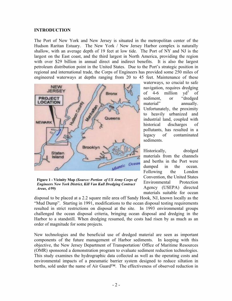
INTRODUCTION The Port of New York and New Jersey is situated in the metropolitan center of the Hudson Raritan Estuary. The New York / New Jersey Harbor complex is naturally shallow, with an average depth of 19 feet at low tide. The Port of NY and NJ is the largest on the East coast, and the third largest in North America, providing the region with over $29 billion in annual direct and indirect benefits. It is also the largest petroleum distribution point in the United States. Due to the Port’s strategic position in regional and international trade, the Corps of Engineers has provided some 250 miles of engineered waterways at depths ranging from 20 to 45 feet. Maintenance of these
waterways, so crucial to safe navigation, requires dredging of 4-6 million yd3 of sediment, or “dredged material” annually. Unfortunately, the proximity to heavily urbanized and industrial land, coupled with historical discharges of pollutants, has resulted in a legacy of contaminated sediments. Historically, dredged materials from the channels and berths in the Port were dumped in the ocean. Following the London Convention, the United States Environmental Protection Agency (USEPA) directed materials suitable for ocean
disposal to be placed at a 2.2 square mile area off Sandy Hook, NJ, known locally as the “Mud Dump”. Starting in 1991, modifications to the ocean disposal testing requirements resulted in strict restrictions on disposal at the site. In 1993 environmental groups challenged the ocean disposal criteria, bringing ocean disposal and dredging in the Harbor to a standstill. When dredging resumed, the costs had risen by as much as an order of magnitude for some projects. New technologies and the beneficial use of dredged material are seen as important components of the future management of Harbor sediments. In keeping with this objective, the New Jersey Department of Transportation/ Office of Maritime Resources (OMR) sponsored a demonstration program to evaluate sediment reduction technologies. This study examines the hydrographic data collected as well as the operating costs and environmental impacts of a pneumatic barrier system designed to reduce siltation in berths, sold under the name of Air Guard™. The effectiveness of observed reduction in
Figure 1 - Vicinity Map (Source: Portion of US Army Corps of Engineers New York District, Kill Van Kull Dredging Contract Areas, 4/99)
- 3 -
sedimentation is compared with the costs of operating the system, and finally weighed against the present and future costs of dredging and disposal. I. AIR CURTAIN TECHNOLOGY
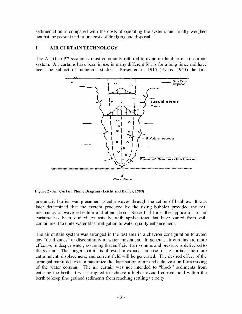
The Air Guard™ system is most commonly referred to as an air-bubbler or air curtain system. Air curtains have been in use in many different forms for a long time, and have been the subject of numerous studies. Presented in 1915 (Evans, 1955) the first
pneumatic barrier was presumed to calm waves through the action of bubbles. It was later determined that the current produced by the rising bubbles provided the real mechanics of wave reflection and attenuation. Since that time, the application of air curtains has been studied extensively, with applications that have varied from spill containment to underwater blast mitigation to water quality enhancement. The air curtain system was arranged in the test area in a chevron configuration to avoid any “dead zones” or discontinuity of water movement. In general, air curtains are more effective in deeper water, assuming that sufficient air volume and pressure is delivered to the system. The longer that air is allowed to expand and rise to the surface, the more entrainment, displacement, and current field will be generated. The desired effect of the arranged manifolds was to maximize the distribution of air and achieve a uniform mixing of the water column. The air curtain was not intended to “block” sediments from entering the berth, it was designed to achieve a higher overall current field within the berth to keep fine grained sediments from reaching settling velocity
Figure 2 - Air Curtain Plume Diagram (Leicht and Baines, 1989)
- 4 -
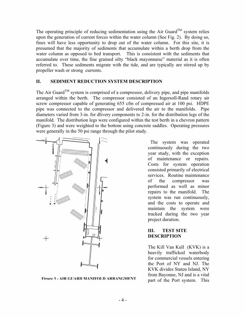
The operating principle of reducing sedimentation using the Air GuardTM system relies upon the generation of current forces within the water column (See Fig. 2). By doing so, fines will have less opportunity to drop out of the water column. For this site, it is presumed that the majority of sediments that accumulate within a berth drop from the water column as opposed to bed transport. This is consistent with the sediments that accumulate over time, the fine grained silty “black mayonnaise” material as it is often referred to. These sediments migrate with the tide, and are typically are stirred up by propeller wash or strong currents. II. SEDIMENT REDUCTION SYSTEM DESCRIPTION The Air GuardTM system is comprised of a compressor, delivery pipe, and pipe manifolds arranged within the berth. The compressor consisted of an Ingersoll-Rand rotary air screw compressor capable of generating 655 cfm of compressed air at 100 psi. HDPE pipe was connected to the compressor and delivered the air to the manifolds. Pipe diameters varied from 3-in. for dlivery components to 2-in. for the distribution legs of the manifold. The distribution legs were configured within the test berth in a chevron pattern (Figure 3) and were weighted to the bottom using concrete saddles. Operating pressures were generally in the 50 psi range through the pilot study.
The system was operated continuously during the two year study, with the exception of maintenance or repairs. Costs for system operation consisted primarily of electrical services. Routine maintenance of the compressor was performed as well as minor repairs to the manifold. The system was run continuously, and the costs to operate and maintain the system were tracked during the two year project duration. III. TEST SITE DESCRIPTION
The Kill Van Kull (KVK) is a heavily trafficked waterbody for commercial vessels entering the Port of NY and NJ. The KVK divides Staten Island, NY from Bayonne, NJ and is a vital part of the Port system. This Figure 3 - AIR GUARD MANIFOLD ARRANGMENT
- 5 -
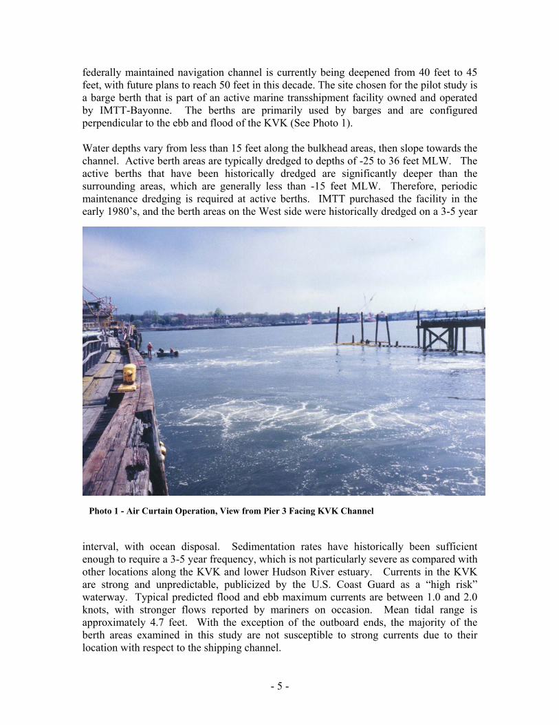
federally maintained navigation channel is currently being deepened from 40 feet to 45 feet, with future plans to reach 50 feet in this decade. The site chosen for the pilot study is a barge berth that is part of an active marine transshipment facility owned and operated by IMTT-Bayonne. The berths are primarily used by barges and are configured perpendicular to the ebb and flood of the KVK (See Photo 1).
Water depths vary from less than 15 feet along the bulkhead areas, then slope towards the channel. Active berth areas are typically dredged to depths of -25 to 36 feet MLW. The active berths that have been historically dredged are significantly deeper than the surrounding areas, which are generally less than -15 feet MLW. Therefore, periodic maintenance dredging is required at active berths. IMTT purchased the facility in the early 1980’s, and the berth areas on the West side were historically dredged on a 3-5 year
interval, with ocean disposal. Sedimentation rates have historically been sufficient enough to require a 3-5 year frequency, which is not particularly severe as compared with other locations along the KVK and lower Hudson River estuary. Currents in the KVK are strong and unpredictable, publicized by the U.S. Coast Guard as a “high risk” waterway. Typical predicted flood and ebb maximum currents are between 1.0 and 2.0 knots, with stronger flows reported by mariners on occasion. Mean tidal range is approximately 4.7 feet. With the exception of the outboard ends, the majority of the berth areas examined in this study are not susceptible to strong currents due to their location with respect to the shipping channel.
Photo 1 - Air Curtain Operation, View from Pier 3 Facing KVK Channel
- 6 -
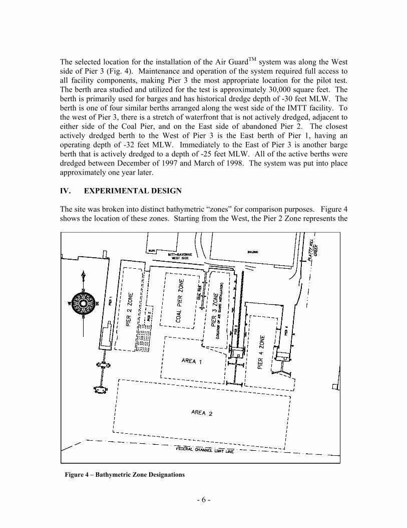
The selected location for the installation of the Air GuardTM system was along the West side of Pier 3 (Fig. 4). Maintenance and operation of the system required full access to all facility components, making Pier 3 the most appropriate location for the pilot test. The berth area studied and utilized for the test is approximately 30,000 square feet. The berth is primarily used for barges and has historical dredge depth of -30 feet MLW. The berth is one of four similar berths arranged along the west side of the IMTT facility. To the west of Pier 3, there is a stretch of waterfront that is not actively dredged, adjacent to either side of the Coal Pier, and on the East side of abandoned Pier 2. The closest actively dredged berth to the West of Pier 3 is the East berth of Pier 1, having an operating depth of -32 feet MLW. Immediately to the East of Pier 3 is another barge berth that is actively dredged to a depth of -25 feet MLW. All of the active berths were dredged between December of 1997 and March of 1998. The system was put into place approximately one year later. IV. EXPERIMENTAL DESIGN The site was broken into distinct bathymetric “zones” for comparison purposes. Figure 4 shows the location of these zones. Starting from the West, the Pier 2 Zone represents the
Figure 4 – Bathymetric Zone Designations
- 7 -
inshore portion of an active berth adjacent to Pier 1. This berth is routinely dredged to el. -32 feet MLW. Moving Eastward, the remains of Pier 2 were omitted, with the next zone being the West side of the Coal Pier. The Coal Pier is a narrow pile supported trestle that is not used for berthing. The Coal Pier Zone is not typically dredged and has not been dredged to our knowledge in the last 10 to 20 years. Continuing Eastward past the Coal Pier, the Pier 3 Zone is located on the West side of Pier 3. This also represents the inshore portion of an active barge berth that was dredged to el. -31.5 feet MLW in 1997. The last inshore zone is located between Pier 3 and Pier 4, and was not dredged in 1997. This is a smaller berth that does not accommodate deep draft vessels. Two offshore areas, Area 1 and Area 2 were also examined during the bathymetric analysis. These areas were selected because of their bathymetric characteristics. Area 1 is a mildly sloping transitional zone, landward of the Federal Channel and sideslopes. Area 2 includes the sloped channel banks and abuts the Federal Channel limit.
To monitor the effectiveness of the system, bathymetric data was collected on a regular basis. Using a single beam transducer and running survey transects on a tight five foot grid, a total of seven condition surveys were performed after the initial baseline survey conducted in March of 1999. Each survey was duplicated and compared with previous data to determine the relative change across the site. The effectiveness of the system to reduce sedimentation within the berth was determined by these comparisons.
While bathymetric monitoring was important to document the effectiveness of the system, regulatory agencies on the State and Federal level required ongoing environmental monitoring as a condition of the permit issued. Baseline data was collected at the test side and also at selected control sites. The results of the environmental surveys were reviewed to determine any beneficial impacts that may be associated with the running of the Air Guard TM System.
The biological and site water chemistry sampling sites were established at generally in the berth footprint of Pier 4, Pier 3, and the Coal Pier zones. These were in reasonable proximity to one another and provided a general character of the test area and adjacent berths for comparison purposes. Water samples collected were analyzed for dissolved oxygen (DO), temperature, and salinity. Samples were collected at three depths: surface, mid-column, and bottom. A Wildco dissolved oxygen sampling bottle was used, and all DO samples were fixed in the field using the azid modification of the Winkler or iodometric method. Titration of fixed samples was conducted in the laboratory at the conclusion of each sampling effort in accordance with the Standard Methods for the Analysis of Water and Wastewater (AHPA, 1992). Biological sampling station were monitored for the presence of nekton and pelagic macroinvertebrates. Sampling equipment included trap nets and gill nets. Short trawls were conducted with a 16-ft otter trawl rigged with weighted doors and deployed from a small open vessel. The trawls were repeated at the surface and bottom for each sample area. Trawls at the Pier 4 and Coal Pier zones were conducted through the inter-pier basin from the bulkhead to the channel. The Pier 3 trawls were initiated approximately mid-pier and progressed to the channel, which prevented entanglement of the bottom
- 8 -
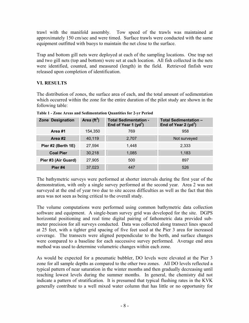
trawl with the manifold assembly. Tow speed of the trawls was maintained at approximately 150 cm/sec and were timed. Surface trawls were conducted with the same equipment outfitted with buoys to maintain the net close to the surface. Trap and bottom gill nets were deployed at each of the sampling locations. One trap net and two gill nets (top and bottom) were set at each location. All fish collected in the nets were identified, counted, and measured (length) in the field. Retrieved finfish were released upon completion of identification. VI. RESULTS The distribution of zones, the surface area of each, and the total amount of sedimentation which occurred within the zone for the entire duration of the pilot study are shown in the following table: Table 1 - Zone Areas and Sedimentation Quantities for 2-yr Period
Zone Designation Area (ft3) Total Sedimentation - End of Year 1 (yd3)
Total Sedimentation – End of Year 2 (yd3)
Area #1 154,350 769 958
Area #2 40,119 2,707 Not surveyed
Pier #2 (Berth 1E) 27,594 1,448 2,333
Coal Pier 30,218 1,085 1,183
Pier #3 (Air Guard) 27,905 500 897
Pier #4 37,023 447 526 The bathymetric surveys were performed at shorter intervals during the first year of the demonstration, with only a single survey performed at the second year. Area 2 was not surveyed at the end of year two due to site access difficulties as well as the fact that this area was not seen as being critical to the overall study. The volume computations were performed using common bathymetric data collection software and equipment. A single-beam survey grid was developed for the site. DGPS horizontal positioning and real time digital pairing of fathometric data provided sub-meter precision for all surveys conducted. Data was collected along transect lines spaced at 25 feet, with a tighter grid spacing of five feet used at the Pier 3 area for increased coverage. The transects were aligned perpendicular to the berth, and surface changes were compared to a baseline for each successive survey performed. Average end area method was used to determine volumetric changes within each zone. As would be expected for a pneumatic bubbler, DO levels were elevated at the Pier 3 zone for all sample depths as compared to the other two zones. All DO levels reflected a typical pattern of near saturation in the winter months and then gradually decreasing until reaching lowest levels during the summer months. In general, the chemistry did not indicate a pattern of stratification. It is presumed that typical flushing rates in the KVK generally contribute to a well mixed water column that has little or no opportunity for
- 9 -
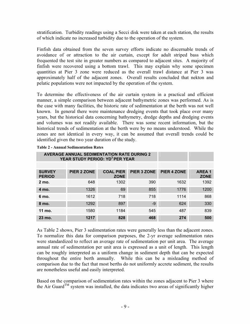
stratification. Turbidity readings using a Secci disk were taken at each station, the results of which indicate no increased turbidity due to the operation of the system. Finfish data obtained from the seven survey efforts indicate no discernable trends of avoidance of or attraction to the air curtain, except for adult striped bass which frequented the test site in greater numbers as compared to adjacent sites. A majority of finfish were recovered using a bottom trawl. This may explain why some specimen quantities at Pier 3 zone were reduced as the overall trawl distance at Pier 3 was approximately half of the adjacent zones. Overall results concluded that nekton and pelatic populations were not impacted by the operation of the system. To determine the effectiveness of the air curtain system in a practical and efficient manner, a simple comparison between adjacent bathymetric zones was performed. As is the case with many facilities, the historic rate of sedimentation at the berth was not well known. In general there were maintenance dredging events that took place over many years, but the historical data concerning bathymetry, dredge depths and dredging events and volumes was not readily available. There was some recent information, but the historical trends of sedimentation at the berth were by no means understood. While the zones are not identical in every way, it can be assumed that overall trends could be identified given the two year duration of the study. Table 2 - Annual Sedimentation Rates
AVERAGE ANNUAL SEDIMENTATION RATE DURING 2 YEAR STUDY PERIOD: YD3 PER YEAR
SURVEY PERIOD
PIER 2 ZONE COAL PIER ZONE
PIER 3 ZONE PIER 4 ZONE AREA 1 ZONE
2 mo. 648 1302 390 1632 1392
4 mo. 1326 69 855 1776 1200
6 mo. 1612 718 718 1114 868
8 mo. 1292 897 -9 624 330
11 mo. 1580 1184 545 487 839
23 mo. 1217 828 468 274 500 As Table 2 shows, Pier 3 sedimentation rates were generally less than the adjacent zones. To normalize this data for comparison purposes, the 2-yr average sedimentation rates were standardized to reflect an average rate of sedimentation per unit area. The average annual rate of sedimentation per unit area is expressed as a unit of length. This length can be roughly interpreted as a uniform change in sediment depth that can be expected throughout the entire berth annually. While this can be a misleading method of comparison due to the fact that most berths do not uniformly accrete sediment, the results are nonetheless useful and easily interpreted.
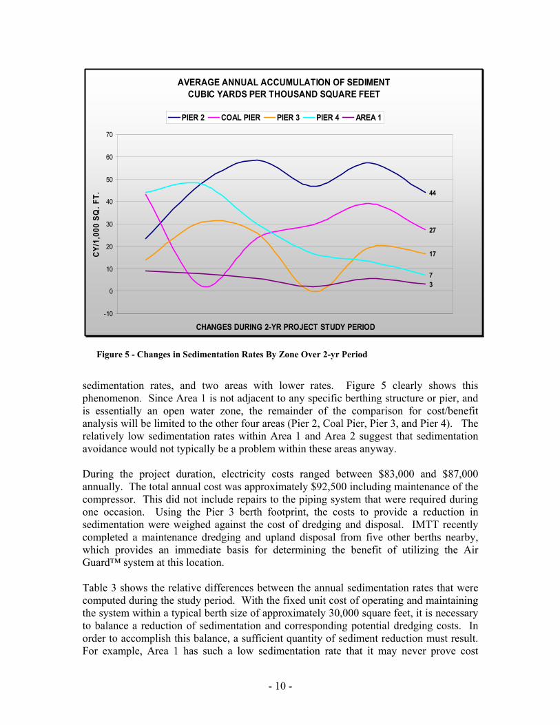
Based on the comparison of sedimentation rates within the zones adjacent to Pier 3 where the Air GuardTM system was installed, the data indicates two areas of significantly higher
- 10 -
sedimentation rates, and two areas with lower rates. Figure 5 clearly shows this phenomenon. Since Area 1 is not adjacent to any specific berthing structure or pier, and is essentially an open water zone, the remainder of the comparison for cost/benefit analysis will be limited to the other four areas (Pier 2, Coal Pier, Pier 3, and Pier 4). The relatively low sedimentation rates within Area 1 and Area 2 suggest that sedimentation avoidance would not typically be a problem within these areas anyway.
During the project duration, electricity costs ranged between $83,000 and $87,000 annually. The total annual cost was approximately $92,500 including maintenance of the compressor. This did not include repairs to the piping system that were required during one occasion. Using the Pier 3 berth footprint, the costs to provide a reduction in sedimentation were weighed against the cost of dredging and disposal. IMTT recently completed a maintenance dredging and upland disposal from five other berths nearby, which provides an immediate basis for determining the benefit of utilizing the Air Guard™ system at this location.
Table 3 shows the relative differences between the annual sedimentation rates that were computed during the study period. With the fixed unit cost of operating and maintaining the system within a typical berth size of approximately 30,000 square feet, it is necessary to balance a reduction of sedimentation and corresponding potential dredging costs. In order to accomplish this balance, a sufficient quantity of sediment reduction must result. For example, Area 1 has such a low sedimentation rate that it may never prove cost
Figure 5 - Changes in Sedimentation Rates By Zone Over 2-yr Period
AVERAGE ANNUAL ACCUMULATION OF SEDIMENTCUBIC YARDS PER THOUSAND SQUARE FEET
44
27
17
73
-10
0
10
20
30
40
50
60
70
CHANGES DURING 2-YR PROJECT STUDY PERIOD
CY/1
,000
SQ
. FT.
PIER 2 COAL PIER PIER 3 PIER 4 AREA 1
- 11 -
effective to implement a reduction technology providing that there are dredged material disposal alternatives in the future. While the data is not completely conclusive, there is a strong degree of certainty that operating the system at Pier 2 or the Coal Pier would have resulted in a lower sedimentation rate. Table 3- Change In Sedimentation Rate Compared with Air Guard Pier 3 Berth
Zone Change at Change at Designation Year 1 Year 2 Pier 2 185% 159% Coal Pier 95% 59% Pier 3 na na Pier 4 -35% -59%
VII. DISCUSSION The use of an air curtain was studied by DeNekker and Knol (1968) at a site along the Rotterdam Waterway which concluded that a 20% reduction in dredging could be achieved, though the costs of operating the system were significant. However, the 1968 pilot study only ran the system during slack water periods, from 2 hours prior to high tide to 3 hours after high tide. The Air GuardTM system was run continuously, which may explain the increased level of effectiveness of sedimentation reduction. It also contributes to higher operational costs.
The present day costs of dredging are driven primarily by the problems associated with dredged material disposal. This has created the need to explore alternative technologies to reduce sedimentation rates. The two year study of the Air GuardTM system which concluded in April of 2001 provides useful information concerning the operational costs, environmental impacts, and overall influence on sedimentation within a berth. The primary question to be resolved is why the sedimentation rates observed in the test area exceed those of Area 1 and Pier 4.
Area 1 is not confined by any pier structures and is frequently crossed by tugs and work vessels in and around the site. The Pier 4 zone, while similar to the other zones that abut an aging bulkhead on the shoreline, has a significant portion which is located outside of the influence of any pier structure. The inshore portion of the Pier 4 Zone also is relatively shallow as compared to the test zone as well as the Pier 2 Zone.
In terms of bathymetric and physical similarity, the Pier 3 test zone and Pier 2 zones are closest. They share similar water depths, overall geometry, and the general physical settings. Figure 5 shows that the difference in sedimentation rates between these two zones during the study period is significant. The similarities of these two areas and the results of the two year study are compelling.
- 12 -
The air curtain technology used requires a significant investment to both purchase and operate. The study has provided current operating costs and sedimentation rates which can be balanced against the costs of dredging and disposal. Using this data, a range of efficiencies can be assumed in terms of overall sedimentation reduction within a similarly sized berth area.
A sufficient reduction of sediment volume is required to justify the costs of operating an air curtain system. In the case of the IMTT berth at Pier 3 a series of curves can be plotted to determine whether or not the system can be economically justified. Figure 5 shows varying efficiencies of sedimentation reduction ranging from 20% to 50%. This is a reasonable range that can be expected based upon the results of the study. For each level of efficiency, the normal rate of accumulation within the berth is compared to the total cost of dredging and disposal.
It should be pointed out that typical dredging and disposal costs within the NY/NJ harbor area for maintenance dredging are presently in the $50-75 per cubic yard range. These costs typically do not include mobilization, sediment sampling and testing, permitting, or any other soft costs. Using Figure 6, assuming 40% reduction efficiency, a berth having a normal sedimentation rate of 2.1 feet per year would benefit from the use of the Air Guard system when total dredging costs exceed $100 per cubic yard.
Sedimentation Rate vs. Dredging CostBreak Even Curve Balancing Annual Dredging Costs vs. Air Guard Operating Costs
Assuming Uniform Siltation Rates Over a Berth Area Similar to Pier 3 Site and Typical Annual Operating Costs of $92,500
$0
$50
$100
$150
$200
$250
$300
$350
$400
$450
1.0 1.5 2.0 2.5 3.0 3.5 4.0 4.5 5.0
Normal Annual Siltation Rate Over a 30,000 sq. ft. Berth (ft/yr)
Figure 6 - Cost/Benefit for Various Air Guard Efficiencies
- 13 -
VIII. CONCLUSIONS Reduction of sedimentation rates can be expected through the use of an air curtain system. The study concluded that reductions can be achieved with an air curtain without negative environmental impacts to water quality or biological activity. The effectiveness of the system will depend upon the environmental conditions, water depth, and source of sedimentation. It is reasonable to conclude that for most typical port and harbor berth areas, benefits can be derived which must be weighed against the cost of dredging and disposal. The primary conclusions are as follows: • The Air GuardTM test area (Pier 3 zone) is most similar to the Pier 2 zone.
Sedimentation rates at the Pier 2 zone were 159% higher as compared to the test area over the course of the two year study.
• Environmental testing of site water chemistry and biological sampling indicated
no adverse impacts resulted as a result of the operation of the system. • The costs associated with operation and maintenance during the study can be
assumed to be conservative. Limiting the operation to slack water periods will greatly reduce these costs, and may have little impact on overall sedimentation reduction.
• Economic justification to use the Air GuardTM system require generally higher
sedimentation rates than were measured at the test site based on present day dredging and disposal costs of $50-75 per cubic yard.
REFERENCES Eldon, C.D., and Sollitt, C.K., 1992. Air Guard Containment System Current Generation and Wave Response Test, Final Report De Nekker, J., and Knol, J. 1968. Results of Experiments With an Air-Bubble Screen Against Siltation in the Rotterdam Harbour. This study was made possible through a grant from the Port Authority of New York and New Jersey.