+ All Categories
Home > Documents > Evaluation of ALOS PALSAR Data for Forest...

Evaluation of ALOS PALSAR Data for Forest...

Date post: 10-Jun-2018
Category:
Upload: lenhu
View: 213 times
Download: 0 times
Share this document with a friend
24
©ALOS 2008 Symposium, Rhodes, Greece 3 – 7 November, 2008 Natural Resources Canada Ressources naturelles Canada Canadian Forest Service Service canadien des forêts Evaluation of ALOS PALSAR Data for Forest Classification David G. Goodenough 1,2 , Hao Chen 1 , Andrew Dyk 1 Geordie Hobart 1,2 , Ashlin Richardson 1 1 Pacific Forestry Centre – Natural Resources Canada 2 Department of Computer Science – University of Victoria
Transcript

©ALOS 2008 Symposium, Rhodes, Greece3 – 7 November, 2008

Natural Resources Canada

Ressources naturelles Canada

Canadian ForestService

Service canadien des forêts

Evaluation of ALOS PALSAR Data for Forest Classification

David G. Goodenough1,2, Hao Chen1, Andrew Dyk1

Geordie Hobart1,2, Ashlin Richardson1

1 Pacific Forestry Centre – Natural Resources Canada2Department of Computer Science – University of Victoria

©ALOS 2008 Symposium, Rhodes, Greece3 – 7 November, 2008

Natural Resources Canada

Ressources naturelles Canada

Canadian ForestService

Service canadien des forêts

Overview

Background information Study site and challengesData collection and softwarePALSAR data processing techniques ClassificationConclusionsAcknowledgements

©ALOS 2008 Symposium, Rhodes, Greece3 – 7 November, 2008

Natural Resources Canada

Ressources naturelles Canada

Canadian ForestService

Service canadien des forêts

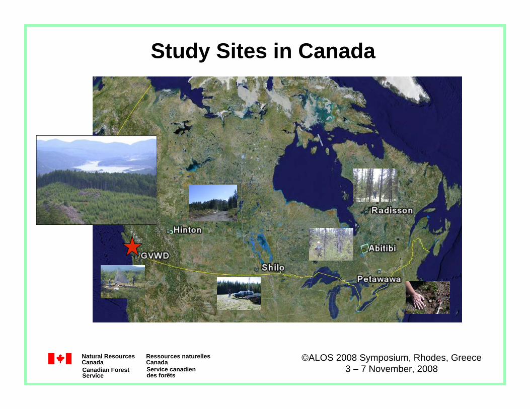
Polarimetric SAR for Forestry Canada contains 10% of the world’s forest cover and 30% of the world’s boreal forest. Canadian Forest Service (CFS), Natural Resources Canada (NRCan), has national programs and reporting needs requiring up-to-date information on the state and changes in Canada’s forests. Advanced ALOS PALSAR quad-pol data can contribute to:

Forest land classification Forest change detectionBurned area identificationBiomass mapping

Challenges:Significant topographic relief common in forested areas of CanadaMultifrequency combinations of polarimetric radars

©ALOS 2008 Symposium, Rhodes, Greece3 – 7 November, 2008

Natural Resources Canada

Ressources naturelles Canada

Canadian ForestService

Service canadien des forêts

Study Sites in Canada

©ALOS 2008 Symposium, Rhodes, Greece3 – 7 November, 2008

Natural Resources Canada

Ressources naturelles Canada

Canadian ForestService

Service canadien des forêts

GVWD Data Collection

Data parameters

Nadir20cmOrthoSummer 2007AirborneAir Photo

Nadir2mFirst & LastSep. 11, 2006AirborneLIDAR

21.5º4.5m /9.5mQuad-pol (L)Jul. 9, 2007ALOSPALSAR

21.5º4.5m /9.5mQuad-pol (L)Aug. 11, 2008ALOSPALSAR

41º9m /10mQuad-pol (C)Jul. 7, 2008Radarsat-2Radarsat-2

N/A1:10,000 PolygonsUpdated in 2007GISForest cover

41º9m /10m Quad-pol (C)Jul. 24, 2008Radarsat-2Radarsat-2

Inc. angleAzimuth/rangeModeDate PlatformSensor

©ALOS 2008 Symposium, Rhodes, Greece3 – 7 November, 2008

Natural Resources Canada

Ressources naturelles Canada

Canadian ForestService

Service canadien des forêts

Due to electron density in the ionosphere and is manifested as arotation by angle β of the polarized wave*. Estimating β is from the Bickel and Bates approach**:

“arg” is the angular component of the complex number, between πand - π. Z12 and Z21 are defined by a simple transformation of [S] to a circular basis.

Faraday Rotation Estimation

⎥⎦

⎤⎢⎣

⎡⎥⎦

⎤⎢⎣

⎡⎥⎦

⎤⎢⎣

⎡=⎥

⎤⎢⎣

⎡1

11

1

2212

2111

2212

2111

jj

SSSS

jj

ZZZZ

)arg(41 *

2112ZZ=β

©ALOS 2008 Symposium, Rhodes, Greece3 – 7 November, 2008

Natural Resources Canada

Ressources naturelles Canada

Canadian ForestService

Service canadien des forêts

Faraday Rotation CorrectionTo correct for a Faraday Rotation of β, the following matrix multiplication should suffice:

(Non-symmetric data, where HV VH, is required to calculate β.)PALSAR Level 1.1 quad-pol data: β <= 2ºRadarsat-2 FQ data: β ≈ 0º

Anthony Freeman, “Calibration of Linearly Polarized Polarimetric SAR Data Subject to Faraday Rotation,” IEEE Transactions on Geoscience and Remote Sensing, Vol.42, No.8, August 2004.

⎥⎦

⎤⎢⎣

⎡ −⎥⎦

⎤⎢⎣

⎡⎥⎦

⎤⎢⎣

⎡ −=

⎥⎥⎦

⎢⎢⎣

ββββ

ββββ

cossinsincos

cossinsincos

2212

2111

22

~

12

~21

~

11

~

SSSS

SSSS

©ALOS 2008 Symposium, Rhodes, Greece3 – 7 November, 2008

Natural Resources Canada

Ressources naturelles Canada

Canadian ForestService

Service canadien des forêts

Polarimetric SAR data compensation for terrain azimuth slope variation – critical for mountainous terrain:

1) Jong-Sen Lee, D. L. Schuler, T. L. Ainsworth, E. Krogager, D. Kasilingam, and W. Boerner, "On the Estimation of Radar Polarization Orientation Shifts Induced by Terrain Slopes", IEEE Transactions On Geoscience and Remote Sensing, Vol. 40, No. 1, January 2002.

2) Jong-Sen Lee, D. L. Schuler, and T. L. Ainsworth, "Polarimetric SAR Data Compensation for Terrain Azimuth Slope Variation", IEEE Transactions On Geoscience and Remote Sensing, Vol. 38, No. 5, September 2000.

Orientation angle induced by azimuth slope:

Polarization Orientation Shifts

⎪⎪⎩

⎪⎪⎨

>−

≤=

4/,2/

4/,

πηπη

πηηθ

if

if ( )( )⎥⎥⎥

⎢⎢⎢

⎡+

⎟⎟⎟

⎜⎜⎜

+−−

−−= − πη

22

*1

4

Re4tan

41

hvvvhh

hvvvhh

SSS

SSS

©ALOS 2008 Symposium, Rhodes, Greece3 – 7 November, 2008

Natural Resources Canada

Ressources naturelles Canada

Canadian ForestService

Service canadien des forêts

Given θ, compensate scattering matrix (S2)

A θ image below derived from an 1996 AirSAR P-band data over Camp Roberts, California, using our implementation matched the results published in the Dr. Lee’s paper.

θ image derived from AirSAR P-band data over Camp Roberts

θ Compensation (1)

( ) ( )( ) ( )

( ) ( )( ) ( ) ⎥⎦

⎤⎢⎣

⎡ −⎥⎦

⎤⎢⎣

⎡⎥⎦

⎤⎢⎣

⎡−

=θθθθ

θθθθ

cossinsincos

cossinsincos

2221

1211)(

SSSS

S new

©ALOS 2008 Symposium, Rhodes, Greece3 – 7 November, 2008

Natural Resources Canada

Ressources naturelles Canada

Canadian ForestService

Service canadien des forêts

A θ image derived from an 2008 PALSAR L-band data over Hinton, AB (8 look azimuth, 4 look range, 7x7 filtered).

A Pauli RGB image from the same PALSAR data.

θ Compensation (2)

©ALOS 2008 Symposium, Rhodes, Greece3 – 7 November, 2008

Natural Resources Canada

Ressources naturelles Canada

Canadian ForestService

Service canadien des forêts

Decomposition to Reduce Topographic EffectsBased on the Shane Cloude’s Entropy-alpha decomposition of a 4x4 coherency matrix.(Requires non-symmetric scattering matrix [S].)

Four eigenvalues - calculating scattering entropy H.The second and third eigenvalues (λ2, λ3) - calculating for the ‘diffuse’or non-polarized power as (λ2 + λ3).α2 - scattering angle alpha for the second eigenvector.

The triplet (α2, H, λ2 + λ3) are used as an HSV coding interpretation. By excluding λ1 and α1, the topography effects can be minimized.

S. Cloude, E. Chen, Z. Li, X. Tian, Y. Pang, S. Li, E. Pottier, L. Ferro-Famil, M. Neumann, W. Hong, F. Cao, Y. P. Wang, K. P. Papathanassiou, “FOREST STRUCTURE ESTIMATION USING SPACE BORNE POLARIMETRIC RADAR: AN ALOS-PALSAR CASE STUDY,” ESA Dragon Project, 2007.

©ALOS 2008 Symposium, Rhodes, Greece3 – 7 November, 2008

Natural Resources Canada

Ressources naturelles Canada

Canadian ForestService

Service canadien des forêts

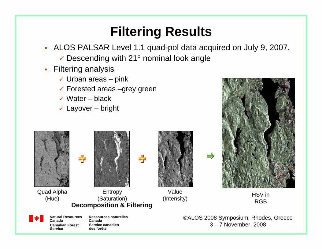
The HSV Image CodingFirst channel (Hue) α2 parameterHelp identifying mechanisms in medium / high entropy (forested areas). Second channel (Saturation) Entropy HControl the saturation so that forested areas remain black and white, while non-forested areas remain in colour. Third channel (Value) Sum of the minor eigenvalues λ2 + λ3Reduce amplitude modulations due to topography variations by considering only the ‘diffuse’ backscatter component.

Depolarizing volume scattering can be well represented for separation of forested areas from non forested areas.Water surface can be identified effectively.

©ALOS 2008 Symposium, Rhodes, Greece3 – 7 November, 2008

Natural Resources Canada

Ressources naturelles Canada

Canadian ForestService

Service canadien des forêts

Filtering ResultsALOS PALSAR Level 1.1 quad-pol data acquired on July 9, 2007.

Descending with 21° nominal look angleFiltering analysis

Urban areas – pinkForested areas –grey greenWater – blackLayover – bright

Quad Alpha (Hue)

Entropy (Saturation)

Value (Intensity)

HSV in RGBDecomposition & Filtering

©ALOS 2008 Symposium, Rhodes, Greece3 – 7 November, 2008

Natural Resources Canada

Ressources naturelles Canada

Canadian ForestService

Service canadien des forêts

Application: Orthorectification

The products image was trimmed prior to orthorectification to remove antenna pattern at the edge of image

SARSIM1 DEMPALSAR HSV

©ALOS 2008 Symposium, Rhodes, Greece3 – 7 November, 2008

Natural Resources Canada

Ressources naturelles Canada

Canadian ForestService

Service canadien des forêts

Classified PALSAR image

Using HSV image only:Average accuracy = 85.1%Overall accuracy = 83.1%

Using HSV image with Slope + Aspect from LIDAR DEM

Average accuracy = 89.5%Overall accuracy = 90.6%

5 classes:Water, Swamp, Grass, Clearcuts and Shrub, Forest

Application: Classification

©ALOS 2008 Symposium, Rhodes, Greece3 – 7 November, 2008

Natural Resources Canada

Ressources naturelles Canada

Canadian ForestService

Service canadien des forêts

Application: Fusion Classification

The target radar images were filtered with a 7 by 7 boxcar filter and decomposed to produce an Entropy, Alpha, Lambda imageThe AVIRIS image was processed using Minimum Noise Fraction

to create five image channelsThe DEM was generated using a LIDAR with 2m resolutionOur non-parametric classification tool – LOGIT – was employed

©ALOS 2008 Symposium, Rhodes, Greece3 – 7 November, 2008

Natural Resources Canada

Ressources naturelles Canada

Canadian ForestService

Service canadien des forêts

Application: ClassificationResults Analysis

86.5%

71.1%

58.7%

68.9%

91.5%86.5%

75.0%

59.8%

70.8%

91.6%

0%

20%

40%

60%

80%

100%

AVIR

IS

(5 M

NF)

PA

LSA

R

RS

2

PA

LSA

RR

S2

PA

LSA

RR

S2A

VIR

IS(M

NF5

)

Average Overall

©ALOS 2008 Symposium, Rhodes, Greece3 – 7 November, 2008

Natural Resources Canada

Ressources naturelles Canada

Canadian ForestService

Service canadien des forêts

GVWD Radarsat-2 Image

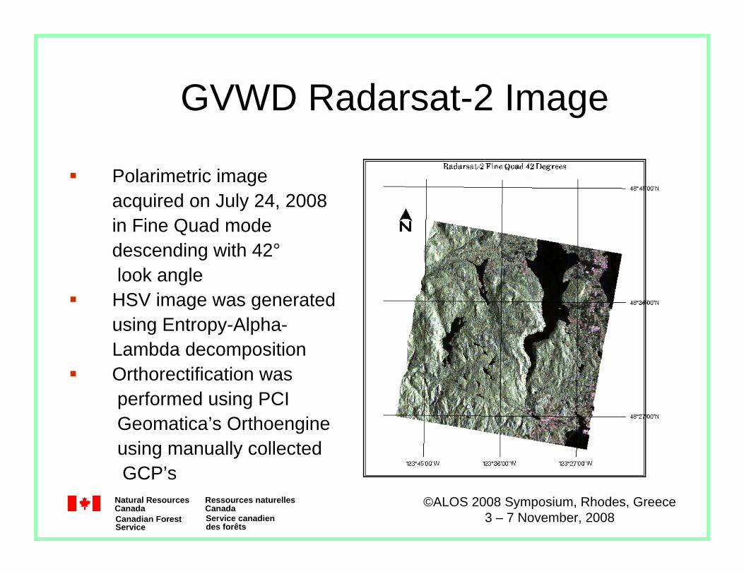
Polarimetric image acquired on July 24, 2008in Fine Quad mode descending with 42°look angleHSV image was generatedusing Entropy-Alpha-Lambda decompositionOrthorectification was performed using PCI Geomatica’s Orthoengineusing manually collected GCP’s

©ALOS 2008 Symposium, Rhodes, Greece3 – 7 November, 2008

Natural Resources Canada

Ressources naturelles Canada

Canadian ForestService

Service canadien des forêts

Historical wildfire, occurred in 1956, shown in Entropy-alpha decomposition of Convair-580 data (57º). 4m x 4m; 11 x 11 filter.

Entropy-alpha-lambda decomposition Radarsat-2 descending FQ21 (41º).

9m x11m; 11x11 filter.

Application: Fire Scar Identification

Radarsat-2 PK25830 20080711

©ALOS 2008 Symposium, Rhodes, Greece3 – 7 November, 2008

Natural Resources Canada

Ressources naturelles Canada

Canadian ForestService

Service canadien des forêts

Application: Fire Scar Identification

PALSAR Quad-pol Aug 8 2008Entropy-Alpha-Lambda Decomposition

No evidence of fire scar in Entropy-alpha-lambda decomposition of PALSAR Quad-pol L-Band with nominal 21° look angle. Nominal

30 m x 30 m, 11x11 filter.

©ALOS 2008 Symposium, Rhodes, Greece3 – 7 November, 2008

Natural Resources Canada

Ressources naturelles Canada

Canadian ForestService

Service canadien des forêts

PolSARpro v3.0Main software for analyzing and processing polarimetric SAR dataand strong technical support from Dr. Eric Pottier and his team.

Reading PALSAR Level 1.1 data delivered from ASF:ASF = RAT * 10000 = PRO * 14125.477Reading Radarsat-2 Fine Quad-pol data:

Open source support of ingest of Radarsat-2 dual-pol and quad-pol data. There is an absolute shift of 4 pixels in the extracted Radarsat-2 image which will be corrected in the next release. PolSARpro software modules have been organized for automation.

©ALOS 2008 Symposium, Rhodes, Greece3 – 7 November, 2008

Natural Resources Canada

Ressources naturelles Canada

Canadian ForestService

Service canadien des forêts

ConclusionsThis study is to identify applications of ALOS PALSAR appropriate for operational use within the Canadian forest sector.The Faraday Rotation angle of the PALSAR Level 1.1 quad-pol data over GVWD is less than 2º. Jong-Sen Lee’s algorithm for polarimetric SAR compensation for azimuth slope variation was effective on P-band AirSAR data, but not for PALSAR L-band data. Further investigation is required.Shane Cloude’s filtering technique was useful to minimize topography effects in PALSAR data. The depolarizing volume scattering was used to separate forested areas from non-forested areas. The water surface was identified accurately. Fusing data from different sources was performed in the UTM map domain. The PALSAR quad-pol data products were orthorectified and classified for the five landcover classes. The classification results were analyzed. Fusion of PALSAR and Radarsat 2 gave an accuracy of 75% for the classification.

©ALOS 2008 Symposium, Rhodes, Greece3 – 7 November, 2008

Natural Resources Canada

Ressources naturelles Canada

Canadian ForestService

Service canadien des forêts

Future WorkDevelop information products, such as forest structure, classification and mapping historical fire scars, based on polarimetric SAR data. Continue investigating polarimetric SAR backscatter sensitivity to topographic relief and environmental conditions. Study target scattering decomposition algorithms to identify spatial scattering variations of forested areas with polarimetric SAR data.Investigate data fusion of polarimetric SAR data with other remote sensing sources for information products. Develop methodologies for biomass mapping of non-inventoried northern boreal forests with multi-temporal/polarized L-band and C-band SAR data. Collaborate with polarimetric SAR experts in Canada and around the world to understand primary R&D challenges that lie in the extraction and application of information contained in polarimetric SAR.

©ALOS 2008 Symposium, Rhodes, Greece3 – 7 November, 2008

Natural Resources Canada

Ressources naturelles Canada

Canadian ForestService

Service canadien des forêts

Acknowledgements

Financial support from:Natural Resources Canada

Canadian Space AgencySpecial thanks to:

Dr. Eric Pottier for the assistance with PolSARpro;Dr. Jong-Sen Lee for valuable information of polarimetric SAR data compensation for terrain azimuthal slopes.

Dr. Shane Cloude for contributions to forest applications over the challenging topography of the GVWD.

Dr. Franz Meyer for information and assistance with PALSAR Level 1.1 data calibration and Faraday rotation


Recommended