1Postgraduate Program of Environmental Science, Universitas Sriwijaya, Palembang, Indonesia 2Civil Engineering Departement, Andalas University, Padang, Indonesia 3Minning Engineering Departement, Universitas Sriwijaya, Palembang, Indonesia 4Civil Engineering Departement, Universitas Sriwijaya, Palembang, Indonesia 5Physics Departement, Universitas Sriwijaya, Palembang, Indonesia
Abstract. Land subsidence is a problem that often occurs in lowland areas. The impact of land subsidence causes losses in the economic,
physical, ecological and social aspects. The impact of land subsidence could be felt directly and indirectly by the people, so an evaluation of the most frequent (dominant) impacts needs to be done. One method that could be use for assesment using AHP, using pairwise comparisons can be obtained the most frequent (dominant) land subsidence impact. From the results of the study indicate that the direct impact due to land subsidence (weight 0.608)) is more dominant than the indirect impact (0.392). Based on the value of each parameter, three dominant land subsidence impacts
are infrastructure damage with a value of 0.387, an increase in the cost of infrastructure construction and maintenance with a value of 0.193 and a flood of 0.129. The results of observations and ground checking at the Tanjung Api-Api area, there was damage to several floors of residents' homes, damage to road and tilt of trees which were damaged in the economic field was the most dominant impact. While floods and seawater intrusion are not dominant in this area because the area is located in the tidal area.
1 Introduction
Tanjung Api-Api is one of the lowland areas in South Sumatra which is located on the
east coast of Sumatra Island. Lowlands have a crucial function into environmental
management because lowlands are able to accommodate and provide water, prevent coastal abrasion, prevent sea water intrusion, oxygen providers and have unique biodiversity [1,3].
Development of lowlands to be built-up areas will trigger various problems, one of it is
land subsidence. Land subsidence causes direct and indirect impacts to environment, such
as infrastructure damage as cracks in buildings and floor, cracks on the road, damage to
drainage and increased of construction costs [4,5,6] and also causing flooding and
widespread flood areas , sea water intrusion, damage to the drainage system and caused
, 0 (2018)E3S Web of Conferences https://doi.org/10.1051/e3sconf /201868040681st SRICOENV 2018
deformation at building construction so that it has an impact on the economic and social life
[2,9,10,11,14,15,16].
To evaluate the dominant/ crucial impact of land subsidence could be used Analitycal
Hierarchy Process (AHP) Method. Analitycal Hierarchy Process is a multilevel structure
method in determining decisions using complex multi criteria. Evaluation of land
subsidence impact is very crucial to determine the appropriate mitigation strategy. The
weighting and scoring of each parameter will make it easier to determine the decision to be
chosen [13].
The analytical hierarchy process and sensitivity analysis (AHP-SA) could be used to
evaluated the risk of land subsidence, with weighting and scoring from multicriteria
parameters of causes of land subsidence [11]. To determine the weight of all criteria in the assessment of the hazard of land subsidence, it is done by fuzzy AHP so that the
consistency of the matrix and convergence speed have a high degree of accuracy [7]. To
solve the problem of assessment matrix consistency and factor weight uncertainty could be
used an improved fuzzy analytic hierarchy process, so that it could evaluate the risk of land
subsidence and the related preventive measures are adopted [8]. Disaster Risk Assessment
is carried out using Analytic Hierarchy Process (AHP) and GIS can help in developing
prevention and risk management techniques [12].
Changes in land use/land cover due to the development of the Tanjung Api-Api area as
a special economic area caused environmental degradation. Land subsidence is caused by
several factors, namely natural and human factors [1,3,4,5,6,12]. The conversion of
lowlands to built-up areas will lead to increased building loads, increased population and
increased demand for water so that it can trigger land subsidence in the region. To determine the vulnerability of the area due to land subsidence and the impact it will cause,
an evaluation needs to be done, one of which is by using the Analytic Hierarchy Process
(AHP) method.
2 Materials and Methods
The data used in this study are primary data in the form of questionnaires from
geotechnical, environmental and construction experts. The number of experts used in this
study were 10 expert. Weighting each criterion is done using AHP. To validate AHP
results, field observations and ground check were carried out in the field. The steps for
completing AHP are as follows: a. Literature review to determine the impact of land subsidence
b. Establish a hierarchical structure of land subsidence impact. Decision Making hierarchy
consisting of:
- Level 0 is the goal l of the decision making process
- Level 1 is a decision-making criterion, both quantitative and qualitative criteria.
- Level 2 is a sub-criterion that describes the parts of the criteria
- Level 3 is the alternatives that will be covered or decided in the research.
c. Weighting of the predetermined criteria by comparing criteria one with other criteria
(pairwise comparation) with AHP scale 1 to 9.
d. Checked of the consistency ratio of each questionnaire (CR <0.1, if CR> 0.1 then the
questionnaire must be repeated).
e. Calculating of the geomean of each parameter by using the formula:
Geomean = (y1. y2. y3 ....yn) 1 / n (1)
Where as : y1 = expert 1, y2 = expert 2, n = number of experts
, 0 (2018)E3S Web of Conferences https://doi.org/10.1051/e3sconf /201868040681st SRICOENV 2018
401 177
2
f. After of obtained the main priority in the form of the dominant of land subsidence
impact, then validation is carried out by conducting observations and checking in the
field.
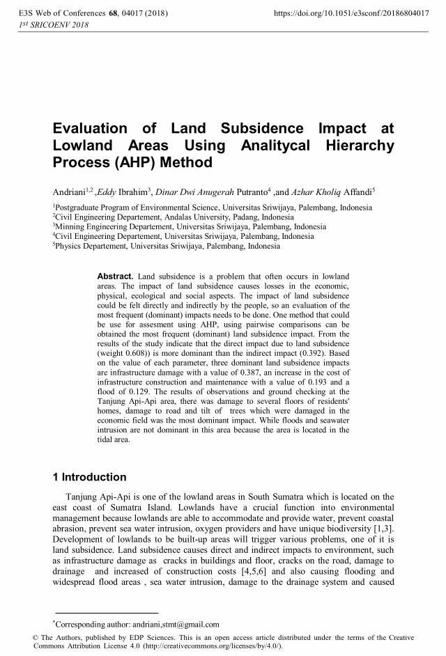
Figure 1 showed the hierarchical structure of the assessment of land subsidence impact
using the Analitycal Hierarchy Process (AHP) method.
Fig. 1. Decision of hierarchy based on Analitycal Hierarchy Process (AHP) Method.
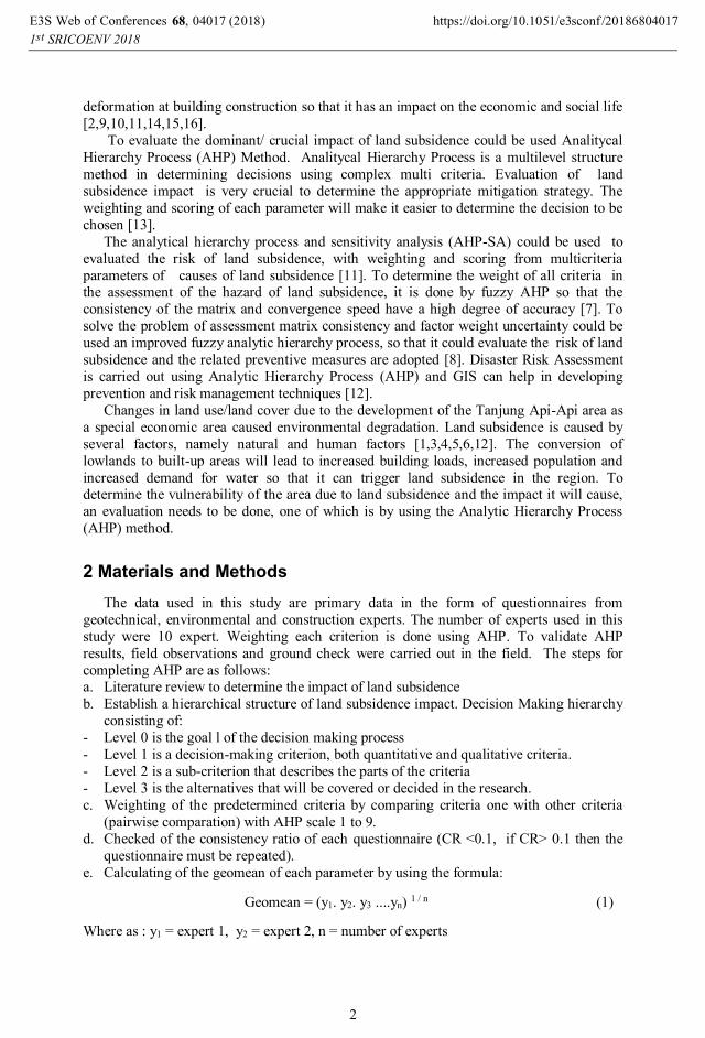
After obtained result of the dominant impact of land subsidence using the AHP method, and then validation is done by observed the impact of land subsidence that has
occurred in the area of Tanjung Api-Api. Figure 2 showed the location of observations in
the field.
Fig. 2. Location of Study Area at Tanjung Api-Api.
, 0 (2018)E3S Web of Conferences https://doi.org/10.1051/e3sconf /201868040681st SRICOENV 2018
401 177
3
3 Results and Discussions
Land subsidence could caused technical and non-technical impacts, causing economic
and social losses. The impact of land subsidence could be felt directly and indirectly by the
people. In general, technical and environmental impacts are impacts that are felt directly by
the community, such as damage to buildings/infrastructure, tidal flooding and sea water
intrusion. While the economic and social impacts were impacts that are not directly felt by
the people. AHP is one solution that could be used to evaluated dominan impact of land
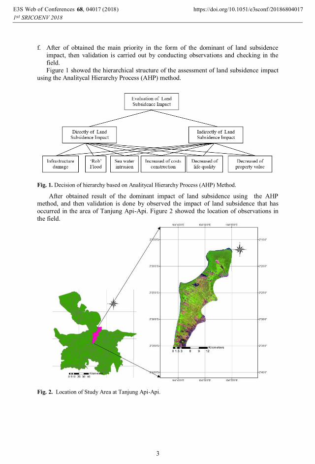
subsidence. Table 1 showed the results of the land subsidence impact with AHP.
Table 1. Results of Evaluation Land Subsidence Impact Using with AHP.
Impact of Land Subsidence Weight Score
Direct Impact of Land Subsidence 1. Damage of Infrastructure
2. Rob Flood
3. Intrusion of Sea Water
0.608
0.638 0.211
0.151
Indirect Impact of Land Subsidence
1. Increased costs of construction and maintenance
of infrastructure 2. Decreased of life quality
3. Decreased of property and infrastructure value
0.392
0.491
0.311 0.198
Total 1.000
Table 1 showed that the direct impact of land subsidence is more dominant than
indirect impacts, direct impacts are impacts that can be felt and seen directly by the
community. In Figure 3, the direct impact that dominan occurs due to land subsidence is damage to buildings / infrastructure compared to the effects of tidal floods and intrusion of
sea water.
Fig. 3. Evaluation of Direct Impact of Land Subsidence with AHP.
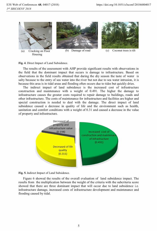
Observations at Tanjung Api-Api area showed that the impact of land subsidence that
had been felt by the people at the study area was the presence of cracks on the floor of the
house/office building Figure 4a, damage to several road sections Figure 4b, and many
coconut trees is tilt Figure 4c.
, 0 (2018)E3S Web of Conferences https://doi.org/10.1051/e3sconf /201868040681st SRICOENV 2018
401 177
4
(a) Cracking on Floor
Housing
(b) Damage of road
(c) Coconut trees is tilt
Fig. 4. Direct Impact of Land Subsidence.
The results of the assessment with AHP provide significant results with observations in
the field that the dominant impact that occurs is damage to infrastructure. Based on
observations in the field results obtained that during the dry season the taste of water is
salty because to the entry of sea water into the river but not due to sea water intrusion, it is
because this area is in tidal areas and flooding often occurs due to tides but quickly dries.
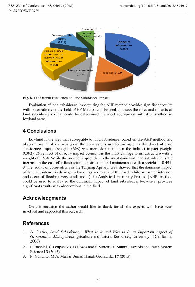
The indirect impact of land subsidence is the increased cost of infrastructure construction and maintenance with a weight of 0.491. The higher the damage to
infrastructure causes the greater costs required to repair damage to buildings, roads and
other infrastructure. The costs of maintenance for infrastructure and facilities are higher and
special construction is needed to deal with the damage. The direct impact of land
subsidence caused a decrease in quality of life and the environment such as health,
sanitation and comfort conditions with a weight of 0.31 and caused a decrease in the value
of property and infrastructure.
Fig. 5. Indirect Impact of Land Subsidence.
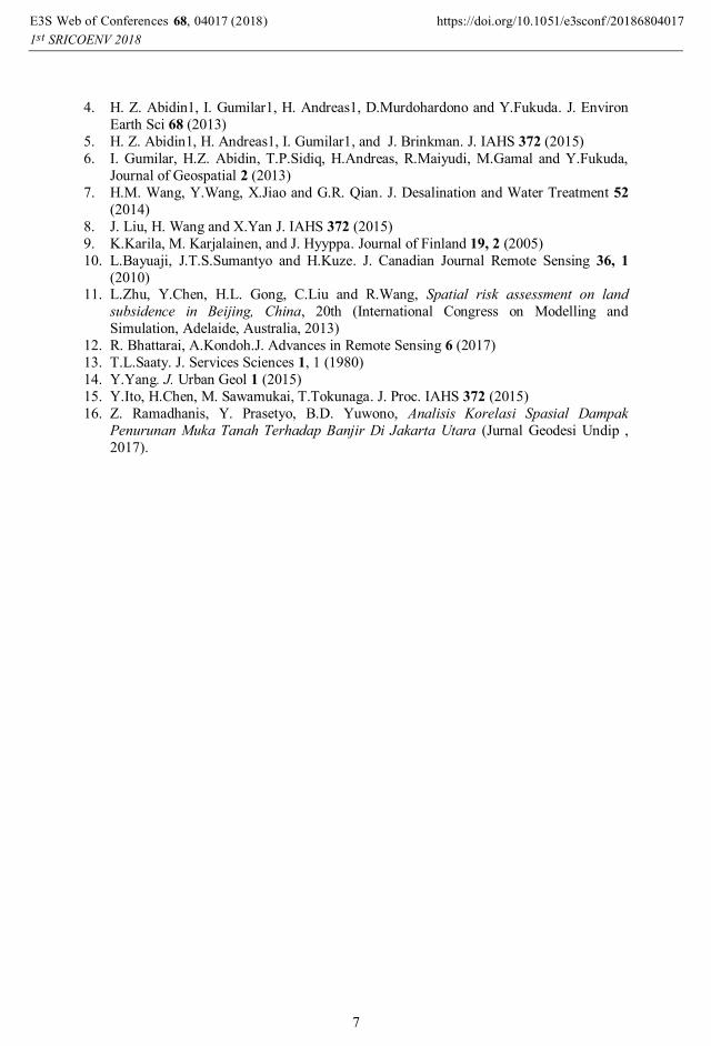
Figure 6 showed the results of the overall evaluation of land subsidence impact. The
results from the multiplication between the weight of the criteria with the subcriteria score
showed that there are three dominant impact that will occur due to land subsidence i.e.
infrastructure damage, increased costs of infrastructure development and maintenance and
flooding caused by tidal.
, 0 (2018)E3S Web of Conferences https://doi.org/10.1051/e3sconf /201868040681st SRICOENV 2018
401 177
5
Fig. 6. The Overall Evaluation of Land Subsidence Impact.
Evaluation of land subsidence impact using the AHP method provides significant results
with observations in the field. AHP Method can be used to assess the risks and impacts of
land subsidence so that could be determined the most appropriate mitigation method in
lowland areas.
4 Conclusions
Lowland is the area that susceptible to land subsidence, based on the AHP method and
observations at study area gave the conclusions are following : 1) the direct of land
subsidence impact (weight 0.608) was more dominant than the indirect impact (weight
0.392), 2)the most of directly impact occurs was the most damage to infrastructure with a
weight of 0.638. While the indirect impact due to the most dominant land subsidence is the
increase in the cost of infrastructure construction and maintenance with a weight of 0.491,
3) the results of observations in the Tanjung Api-Api area showed that the dominant impact
of land subsidence is damage to buildings and crack of the road, while sea water intrusion
and occur of flooding very small,and 4) the Analytical Hierarchy Process (AHP) method could be used to evaluated the dominant impact of land subsidence, because it provides
significant results with observations in the field.
Acknowledgments
On this occasion the author would like to thank for all the experts who have been
involved and supported this research.
References
1. A. Fulton, Land Subsidence : What is It and Why is It an Important Aspect of Groundwater Management (griculture and Natural Resources, University of California,
2006)
2. F. Raspini, C.Loupasakis, D.Rozos and S.Moretti. J. Natural Hazards and Earth System
Science 13 (2013)
3. F. Yulianto, M.A. Marfai. Jurnal Ilmiah Geomatika 17 (2015)
, 0 (2018)E3S Web of Conferences https://doi.org/10.1051/e3sconf /201868040681st SRICOENV 2018
401 177
6
4. H. Z. Abidin1, I. Gumilar1, H. Andreas1, D.Murdohardono and Y.Fukuda. J. Environ
Earth Sci 68 (2013)
5. H. Z. Abidin1, H. Andreas1, I. Gumilar1, and J. Brinkman. J. IAHS 372 (2015)
6. I. Gumilar, H.Z. Abidin, T.P.Sidiq, H.Andreas, R.Maiyudi, M.Gamal and Y.Fukuda,
Journal of Geospatial 2 (2013)
7. H.M. Wang, Y.Wang, X.Jiao and G.R. Qian. J. Desalination and Water Treatment 52
(2014)
8. J. Liu, H. Wang and X.Yan J. IAHS 372 (2015)
9. K.Karila, M. Karjalainen, and J. Hyyppa. Journal of Finland 19, 2 (2005)
10. L.Bayuaji, J.T.S.Sumantyo and H.Kuze. J. Canadian Journal Remote Sensing 36, 1
(2010) 11. L.Zhu, Y.Chen, H.L. Gong, C.Liu and R.Wang, Spatial risk assessment on land
subsidence in Beijing, China, 20th (International Congress on Modelling and
Simulation, Adelaide, Australia, 2013)
12. R. Bhattarai, A.Kondoh.J. Advances in Remote Sensing 6 (2017)
13. T.L.Saaty. J. Services Sciences 1, 1 (1980)
14. Y.Yang. J. Urban Geol 1 (2015)
15. Y.Ito, H.Chen, M. Sawamukai, T.Tokunaga. J. Proc. IAHS 372 (2015)
16. Z. Ramadhanis, Y. Prasetyo, B.D. Yuwono, Analisis Korelasi Spasial Dampak
Penurunan Muka Tanah Terhadap Banjir Di Jakarta Utara (Jurnal Geodesi Undip ,
2017).
, 0 (2018)E3S Web of Conferences https://doi.org/10.1051/e3sconf /201868040681st SRICOENV 2018


![GROUND VERTICAL MOVEMENTS IN URBAN AREAS OF THE … · deformation [4], glacier dynamics [5] and land subsidence [6, 7, 8] being mapped. With regard to land subsidence, SAR interferometry](https://static.documents.pub/doc/80x56/5f818c9969729a09dc1643e6/ground-vertical-movements-in-urban-areas-of-the-deformation-4-glacier-dynamics.jpg)


