36
Gill Sans Bold Biology Preliminary Course Stage 6 Evolution of Australian biota Part 2: Plate tectonics and affinities of Australian biota Incorporating October 2002 AMENDMENTS

Gill Sans Bold
BiologyPreliminary CourseStage 6
Evolution of Australian biota
Part 2: Plate tectonics and affinities of Australian biota
Incorporating October 2002
AMENDMENTS

Part 2: Plate tectonics and affinities of Australian biota 1
Contents
Introduction ............................................................................... 2
Layers of the Earth .................................................................... 4
Major crust plates.................................................................................5
Plate tectonics........................................................................... 9
Break up of ancient supercontinents.................................................10
Evidence for the theory ......................................................................11
Additional resources................................................................ 25
Exercises – Part 2 .................................................................. 33
2 Evolution of Australian biota
Introduction
In the first part of this module the theory of evolution was discussed,particularly in relation to the evolution of the biota of Australia.The evolutionary processes were seen to result from the isolation ofgroups of ancestral organisms. This was followed by these groupschanging under the influence of natural selection over long periodsof time.
The theory of plate tectonics explains how this could have come about.That is, by the northerly movement of the Australian land mass over longperiods of geological time. In this part of the module the theory of platetectonics is discussed and its implications for the evolution of theAustralian biota are considered.
In Part 2 you will be given opportunities to learn to:
• identify and describe evidence that supports the assertion thatAustralia was once part of a landmass called Gondwana including:
– matching continent margins
– position of mid-ocean ridges
– spreading zones between continental plates
– fossils in common on Gondwanan continents, includingGlossopteris and Gangamopteris flora and the marsupials
– similarities between present day organisms on Gondwanancontinents
Part 2: Plate tectonics and affinities of Australian biota 3
In this part you will be given opportunities to:
• solve problems to identify the positions of mid-ocean ridges andspreading zones that infer a moving Australian continent.
• identify data sources, gather process, analyse and presentinformation from secondary sources to draw up a timeline thatidentifies key events in the formation of Australia as an island fromits origins as part of Gondwana
Extract from Biology Stage 6 Syllabus © Board of Studies NSW, originallyissued 1999. Revised November 2002. The most up-to-date version can befound on the Board's website athttp://www.boardofstudies.nsw.edu.au/syllabus_hsc/syllabus2000_lista.html

4 Evolution of Australian biota
Layers of the Earth
The Earth consists of a sphere made up of a series of layers. The mantleand the crust surround the central core. These layers are shown in thediagram below.
700
km
100
km
continental crust
lithosphere(rigid solid)
oceanic crust
upper mantle asthenosphere(capable of flow)
1216 km 2270 km 2185 km 700 km
inner core outer core mantle uppermantle
6371 km
Layers of the Earth.
Part 2: Plate tectonics and affinities of Australian biota 5
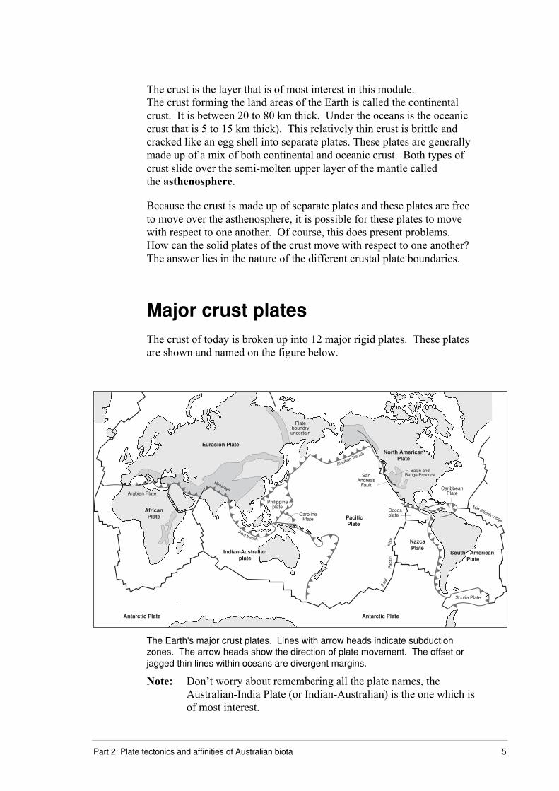
The crust is the layer that is of most interest in this module.The crust forming the land areas of the Earth is called the continentalcrust. It is between 20 to 80 km thick. Under the oceans is the oceaniccrust that is 5 to 15 km thick). This relatively thin crust is brittle andcracked like an egg shell into separate plates. These plates are generallymade up of a mix of both continental and oceanic crust. Both types ofcrust slide over the semi-molten upper layer of the mantle calledthe asthenosphere.
Because the crust is made up of separate plates and these plates are freeto move over the asthenosphere, it is possible for these plates to movewith respect to one another. Of course, this does present problems.How can the solid plates of the crust move with respect to one another?The answer lies in the nature of the different crustal plate boundaries.
Major crust platesThe crust of today is broken up into 12 major rigid plates. These platesare shown and named on the figure below.
Java trench
Eurasion Plate
Plateboundryuncertain
North AmericanPlate
NazcaPlate
South American Plate
Scotia Plate
Antarctic PlateAntarctic Plate
Pacific Plate
Cocosplate
Aleutian Trench
CaribbeanPlate
Philippineplate
CarolinePlate
AfricanPlate
Arabian Plate
Mid Atlantic ridge
Himalays
SanAndreas
Fault
East
Pac
ific
Ris
e
Basin andRange Province
Indian-Australianplate
The Earth's major crust plates. Lines with arrow heads indicate subductionzones. The arrow heads show the direction of plate movement. The offset orjagged thin lines within oceans are divergent margins.
Note: Don’t worry about remembering all the plate names, theAustralian-India Plate (or Indian-Australian) is the one which isof most interest.
6 Evolution of Australian biota
Plate boundaries
The edges of these plates exist as one of three different types of plateboundary. Each type of plate boundary is characterised by differentfeatures and events that occur at the boundary. For simplicity geologistswho study plate boundaries describe them as follows.
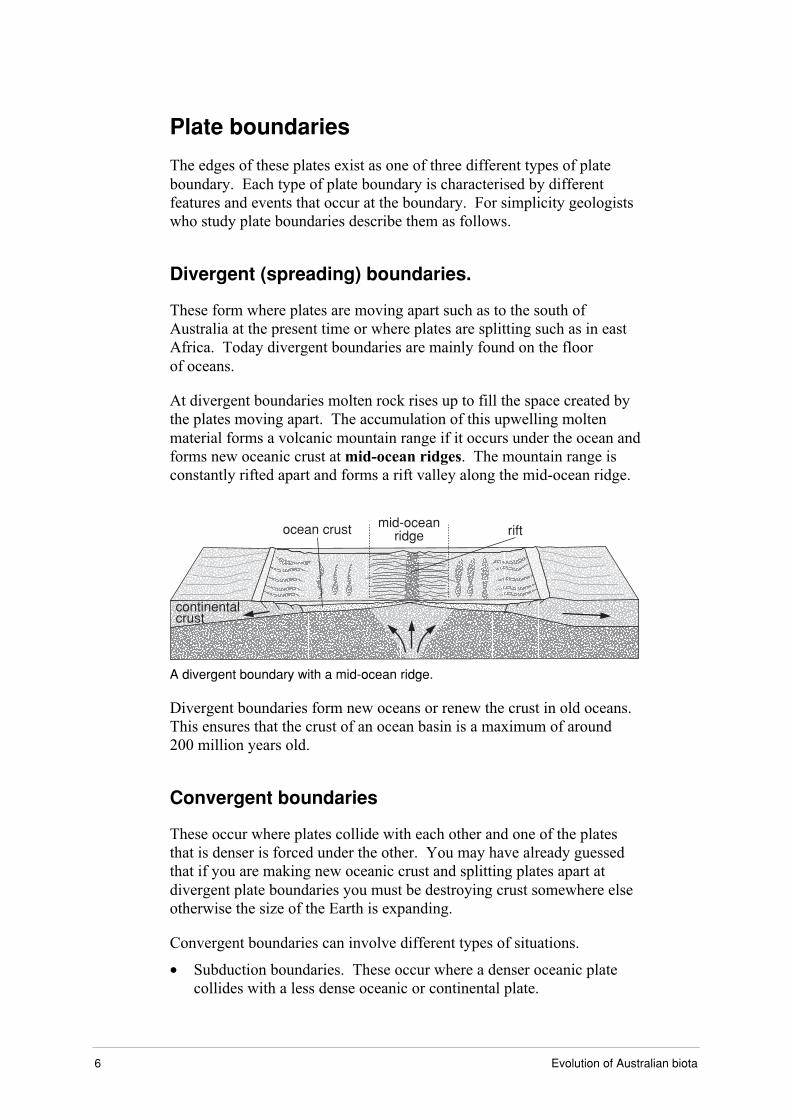
Divergent (spreading) boundaries.
These form where plates are moving apart such as to the south ofAustralia at the present time or where plates are splitting such as in eastAfrica. Today divergent boundaries are mainly found on the floorof oceans.
At divergent boundaries molten rock rises up to fill the space created bythe plates moving apart. The accumulation of this upwelling moltenmaterial forms a volcanic mountain range if it occurs under the ocean andforms new oceanic crust at mid-ocean ridges. The mountain range isconstantly rifted apart and forms a rift valley along the mid-ocean ridge.
continentalcrust
ocean crust riftmid-ocean
ridge
A divergent boundary with a mid-ocean ridge.
Divergent boundaries form new oceans or renew the crust in old oceans.This ensures that the crust of an ocean basin is a maximum of around200 million years old.
Convergent boundaries
These occur where plates collide with each other and one of the platesthat is denser is forced under the other. You may have already guessedthat if you are making new oceanic crust and splitting plates apart atdivergent plate boundaries you must be destroying crust somewhere elseotherwise the size of the Earth is expanding.
Convergent boundaries can involve different types of situations.
∑ Subduction boundaries. These occur where a denser oceanic platecollides with a less dense oceanic or continental plate.

Part 2: Plate tectonics and affinities of Australian biota 7
100 km
200 kmasthenosphere
continental lithosphere
continental crustoceanic trench
asthenosphere
subducting oceanic lithosphere
melting
oceanic crust volcanic arc
∑ The denser crustal plate is forced down under the less dense platecreating a trench adjacent to the collision zone. This generally resultsin volcanoes arising at the edge of the less dense plate.
∑ This type of boundary occurs at the South American and Nazca plateboundary in Chile and Peru. It has resulted in the volcanoes of theAndes Mountains and the formation of the Peru-Chile trench on thewest coast of South America.
∑ Oceanic crust can also be subducted beneath other plates made ofoceanic crust. This occurs to the north east of New Zealand along astructure known as the Tonga- Kermadec Trench. Crust is destroyedat subduction zones.
100 km
200 kmasthenosphere
continental lithosphere
continental crustoceanic trench
asthenosphere
subducting oceanic lithosphere
island arc
melting
oceanic crust
∑ Continental collision boundaries occur where two continental platescollide. This results in mountain formation. The most prominentexample of this occurring is where the plate India is attached to iscolliding and being forced under the Eurasian Plate. The mountainrange that has formed as a result is the tallest in the world today,the Himalayas.

8 Evolution of Australian biota
Continental lithosphere Continental lithosphere
asthenosphere
100 km
200 km
Closer to home the highlands of New Guinea were formed when theAustralian-India (Indo-Australian) plate collided with the largely oceanicplates to its north.
Transform fault boundaries
These boundaries form where plates are moving past each other.At transform faults crust is neither created nor destroyed. This occursalong the north-south axis of New Zealand, where the Pacific andIndo-Australian plates move past each other. This structure is the AlpineFault. Another well known transform fault occurs on the west coast ofthe USA. Part of this fault is the famous San Andreas Fault that runsthrough California.
fault plane
A transform fault boundary
The driving force of plate tectonics is trench pull and trench push.
Look at the map of the major crust plates shown previously and locate eachof the features and plates discussed.
Complete Exercise 2.1.
Part 2: Plate tectonics and affinities of Australian biota 9
Plate tectonics
The idea that landmasses drifted across the face of the Earth was firstseriously suggested by Alfred Wegener in 1912 in his theory ofcontinental drift. He proposed the idea that continents moved around theglobe because he could see no other way to explain the reason for thesimilarities in rocks, fossils and other geological features on either side ofthe Atlantic Ocean. Much of Wegener's hypothesis of continental driftwas based on the apparent geographic fit of the bulge of eastern SouthAmerica and the western coast of Africa. He even went as far as toenvision a single great landmass, Pangaea, which supposedly began toseparate in the Triassic Period around 250 to 208 million years ago.
Wegener had no mechanism to explain how the continents could bemoved so his theory of continental drift was thought to be rubbish bymost scientists. Wegener’s hypothesis languished for the next fourdecades though the observations he had made supporting continental driftremained unexplained.
In 1962 Harold Hess of the USA suggested that convection currents inthe molten part of the mantle were the driving force for the movement ofcontinents. He suggested that new sea floor is created at mid-oceanridges and spreads away from them as it ages. Sam Carey of Tasmaniasuggested the concept of a subduction zone in the late 1950s.Neither had any direct evidence for these ideas and both were criticisedfor a nonscientific approach to a problem. Their hypotheses wereimportant as over the following two decades evidence would show theirideas to be largely correct.
Until the 1990’s it was assumed that convection was the sole driver ofplate motion with slow movement of the mantle dragging the overlyingplates along with it. Since 1994 the ideas of Professor Seiya Uyeda(Tokai University, Japan) that subduction is the major driver of platemotion are becoming increasingly popular. Professor Uyeda’s argumentsare simple. The subducting dense slab literally drags the plate behindit along.

10 Evolution of Australian biota
There may well be some contribution from convection currents in thismotion and some wedging apart of plates in a process known as ridgepush but this contribution is difficult to quantify.
Interestingly much debate is occurring today on this concept and it stillremains a controversial question in geology. In doing any reading on thesubject be aware that Professor Uyeda first published his ideas in 1994.Older books will therefore not consider trench pull as a mechanism ofplate motion. This is a case of an idea in science being born and gainingin impetus. It is still not universally accepted.
Now you will look at the evidence that has turned the concept ofcontinental drift into the theory of plate tectonics.
Break up of ancient supercontinentsFrom around 280 mya all of the major current northern and southernhemisphere continents were joined into one landmass called Pangaea.
Gondwana formation
About 225 mya Pangaea began to break up as the crustal plates began tomove apart. The first division was between the northern supercontinent(Laurasia) and the southern giant landmass of which Australia was part.This southern supercontinent is called Gondwana (or Gondwanaland).Separation was not immediate and took close to 50 million years tocomplete. During this time there was a northward drift and slightanticlockwise rotation of the Gondwanan continent.
Africa
India
Antarctia
SouthAmerica A
ustralia
Madagascar
Gondwana is the former supercontinent in the southern hemisphere. It includedSouth America, Africa, peninsular India, Australia and Antarctica.
The name Gondwanaland was coined by the Austrian geologist EduardSuess who named it from the Upper Paleozoic and Mesozoic formations
Part 2: Plate tectonics and affinities of Australian biota 11
of the Gondwana region of central India, which display typicaldevelopments of many of the shared geologic features that are evident onall separated fragments of the former supercontinent.
Separation of Gondwana
Gondwana finally separated from Laurasia around 170 mya andthen it began to break up around 100 mya into the currentcontinental arrangement.
The isolation of Australia
About 45-35 mya the Indo-Australian plate finally broke away fromAntarctica completely and drifted north, colliding with the plates ofsouth-east Asia about 15 mya.
To see an animation of the break up of Pangaea to the present dayconfiguration of continents see the Biology page of the science website at:
http://www.lmpc.edu.au/science
Evidence for the theoryThe theory of plate tectonics, like Darwin’s theory of evolution, becameaccepted as evidence was collected for its support. Although it is notnecessary in a biology course to investigate this evidence thoroughly, it isimportant to understand why the theory is now widely accepted, as itsimplications are important to evolutionary biology (considered in Parts 1and 3 of this module.)
The evidence that you will be considering is:
• matching continent margins
• position of mid-ocean ridges
• spreading zones between continental plates
• fossils in common on Gondwanan continents, including Glossopterisand Gangamopteris flora and the marsupials
• similarities between present day organisms on Gondwanancontinents.

12 Evolution of Australian biota
Matching continent margins
Evidence to support this theory came from the jigsaw fit of the shape ofcontinents. By the 1600s much of the world's landmasses had beenmapped. In 1620 Francis Bacon pointed out the similarities in shapebetween the continents on either side of the Atlantic Ocean. As well asvisibly matching further research found that the margins of the continentsshared other similarities such as the type and age of rocks and thepresence of earthquakes and volcanoes along the continental margins.
Rock types
The continents are not a perfect jigsaw fit, and so you might reject theidea that they were once joined into one continent. However, geologicalinvestigations have shown similarities in rock types between Africa andSouth America. The figure below shows some similarities in rockformations between the two continents (the same rock formations areshown by the same shading on both continents.)
The probable position of South America and Africa in Gondwana. Areas ofsimilar rock types shared between the two continents are shown asshaded areas.
One problem with simply matching coastlines of continents is that thecontinental shelves are the true boundaries of the continents.

Part 2: Plate tectonics and affinities of Australian biota 13
Earthquakes and volcanoes
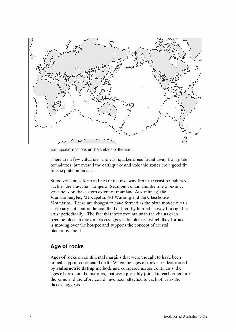
Earthquakes and volcano patterns provide additional evidence forlocating and determining the nature of plate boundaries. When theearthquake epicentres (where the earthquake actually occurred) areplotted on a map they form narrow zones that delineate the edges ofcrustal plates. Areas of volcanic activity are also found alongplate boundaries.
This is a bit like a complicated join-the-dots puzzle. The map followingshows the location of the Earth’s volcanoes. Try to join up the dots on themap, as they should show the crustal plate boundaries.
Location of the Earth's volcanoes.
Is it a bit hard to do? It should help if you look at the next map, whichshows the epicentres of earthquakes. Remember that both earthquakesand volcanic activity occur along plate boundaries. How did you go thistime mapping the plate boundaries?
14 Evolution of Australian biota
������������������������������������������������������������������������������������������������������������������������������������������������� � ������������������������������ � ����������� � �������������������������������������������������������������������� � ������������������������������ � ����������� � �� ����� ��������������������������������������������������������������������������������������������������������������������������������������������������������� � ���������������������������������������������������������������������������������������������������������������������������������������������������������������������������������������������������������������������������������������������������������������������������Earthquake locations on the surface of the Earth
There are a few volcanoes and earthquakes areas found away from plateboundaries, but overall the earthquake and volcanic zones are a good fitfor the plate boundaries.
Some volcanoes form in lines or chains away from the crust boundariessuch as the Hawaiian-Emperor Seamount chain and the line of extinctvolcanoes on the eastern extent of mainland Australia eg. theWarrumbungles, Mt Kapatur, Mt Warning and the GlasshouseMountains. These are thought to have formed as the plate moved over astationary hot spot in the mantle that literally burned its way through thecrust periodically. The fact that these mountains in the chains eachbecome older in one direction suggests the plate on which they formedis moving over the hotspot and supports the concept of crustalplate movement.
Age of rocks
Ages of rocks on continental margins that were thought to have beenjoined support continental drift. When the ages of rocks are determinedby radiometric dating methods and compared across continents, theages of rocks on the margins, that were probably joined to each other, arethe same and therefore could have been attached to each other as thetheory suggests.
Part 2: Plate tectonics and affinities of Australian biota 15
Position of mid-ocean ridges
The ocean floor is not flat. As same as on the land, there are plains,mountains and valleys.
Mid-ocean ridges are volcanic mountain chains. They rise kilometresabove the deep-sea ocean floor and are over 50 000 kilometres long.They are the longest chains of volcanoes on the planet. They are formedby the plates spreading. As the plates move apart the gap is filledwith magma.
The evidence for the position of mid-ocean ridges comes frommagnetism and radiometric dating of the sea floor.
Magnetism
The structure and age of magnetic anomalies adjacent to apparentdivergent margin zones around Australia suggest a history of sea floorspreading and the path of the Australian continent’s drift.
Early in the 20th century, palaeomagnetists such as Bernard Brunhes inFrance and Motonari Matuyama in Japan studied the Earth's ancientmagnetic field. They recognised that igneous rocks like basalt (that makeup most of the ocean floors basement rocks) belong to two groupsaccording to their magnetic properties. One group has normal polarity.That is, the magnetic minerals in the rock have the same polarity as thatof the Earth’s present magnetic field. This would result in the north endof the rocks ‘compass needle’ pointing toward magnetic north. The othergroup of rocks, however, have magnetic minerals with reversed polarity,indicated by a polarity alignment opposite to that of the Earth's presentmagnetic field. In this case, the north end of the rocks compass needlewould point south.
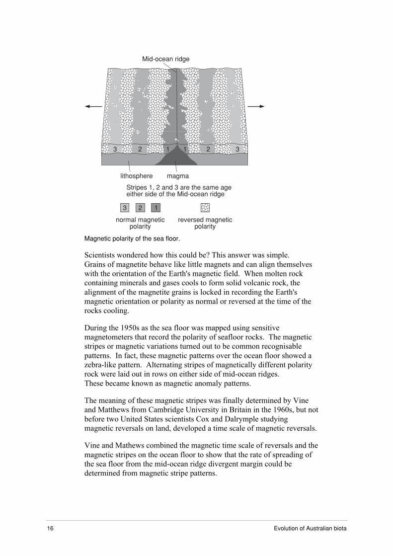
16 Evolution of Australian biota
Mid-ocean ridge
3 2 1 1 2 3
magmalithosphere
normal magneticpolarity
reversed magneticpolarity
Stripes 1, 2 and 3 are the same ageeither side of the Mid-ocean ridge
Magnetic polarity of the sea floor.
Scientists wondered how this could be? This answer was simple.Grains of magnetite behave like little magnets and can align themselveswith the orientation of the Earth's magnetic field. When molten rockcontaining minerals and gases cools to form solid volcanic rock, thealignment of the magnetite grains is locked in recording the Earth'smagnetic orientation or polarity as normal or reversed at the time of therocks cooling.
During the 1950s as the sea floor was mapped using sensitivemagnetometers that record the polarity of seafloor rocks. The magneticstripes or magnetic variations turned out to be common recognisablepatterns. In fact, these magnetic patterns over the ocean floor showed azebra-like pattern. Alternating stripes of magnetically different polarityrock were laid out in rows on either side of mid-ocean ridges.These became known as magnetic anomaly patterns.
The meaning of these magnetic stripes was finally determined by Vineand Matthews from Cambridge University in Britain in the 1960s, but notbefore two United States scientists Cox and Dalrymple studyingmagnetic reversals on land, developed a time scale of magnetic reversals.
Vine and Mathews combined the magnetic time scale of reversals and themagnetic stripes on the ocean floor to show that the rate of spreading ofthe sea floor from the mid-ocean ridge divergent margin could bedetermined from magnetic stripe patterns.

Part 2: Plate tectonics and affinities of Australian biota 17
Ocean floor dating
Sediments containing fossils that can be easily dated increase inthickness and maximum age on either side of a mid-ocean ridge as thedistance from the ridge increases. This suggests the points most distantfrom the mid-ocean ridge are the oldest and the points at the ridge arethe youngest.
Radiometric dating of the ocean floor rarely shows an age in excess of200 million years suggesting that the sea floor is very young and oftenrecycled compared to continental crust. The radiometric ages of sea flooralso increases away from the ridge.
Spreading zones between continentalplates
Evidence for sea floor spreading comes from exploration from deep-seasubmersibles. In 1977 an expedition near the Galapagos Islandsdiscovered hydrothermal vents. The importance of this discovery wasthat the existence of these areas had been hypothesised but never beforeseen. It was a location where new planetary crust is formed as theinjection of new basalt moves the plates apart.
This discovery was followed by the discovery of ‘black smokers’.These are areas where superheated water is discharged from the sea floorloaded with sulfides. These precipitate as they hit the cooler water andhave the appearance of black smoke, thus the name. The discovery wasexciting because at these sites there is whole community of livingorganisms relying on chemosynthesis as a basis for life.
Fossils in common on Gondwanancontinents
Fossils provide some evidence of continents being joined or separate inthe past. If the continents were joined at some stage, you would expectthat fossils or ancestral groups of present day organisms, or even livingrepresentatives in common would be found in the modern continents thatmade up the previous supercontinent.
Similarly, if a species or group evolved on one of the continents after ithad broken away from the supercontinent, you wouldn’t expect to find iton the other separated continent. The evidence from fossils supportsthese expectations.
18 Evolution of Australian biota
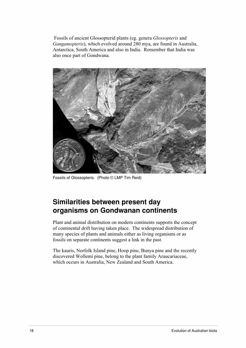
Fossils of ancient Glossopterid plants (eg. genera Glossopteris andGangamopteris), which evolved around 280 mya, are found in Australia,Antarctica, South America and also in India. Remember that India wasalso once part of Gondwana.
Fossils of Glossopteris. (Photo © LMP Tim Reid)
Similarities between present dayorganisms on Gondwanan continents
Plant and animal distribution on modern continents supports the conceptof continental drift having taken place. The widespread distribution ofmany species of plants and animals either as living organisms or asfossils on separate continents suggest a link in the past.
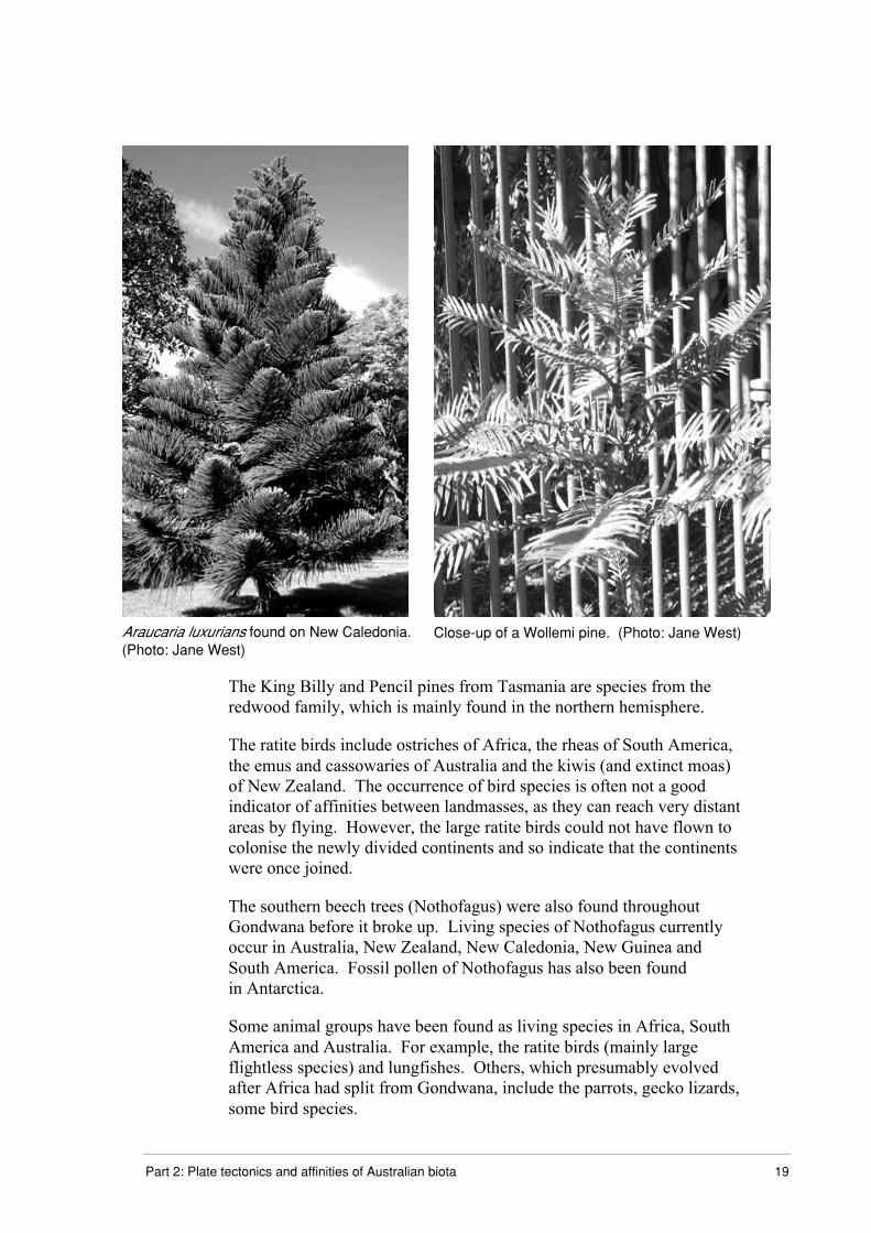
The kauris, Norfolk Island pine, Hoop pine, Bunya pine and the recentlydiscovered Wollemi pine, belong to the plant family Araucariaceae,which occurs in Australia, New Zealand and South America.
Part 2: Plate tectonics and affinities of Australian biota 19
Araucaria luxurians found on New Caledonia.(Photo: Jane West)
Close-up of a Wollemi pine. (Photo: Jane West)
The King Billy and Pencil pines from Tasmania are species from theredwood family, which is mainly found in the northern hemisphere.
The ratite birds include ostriches of Africa, the rheas of South America,the emus and cassowaries of Australia and the kiwis (and extinct moas)of New Zealand. The occurrence of bird species is often not a goodindicator of affinities between landmasses, as they can reach very distantareas by flying. However, the large ratite birds could not have flown tocolonise the newly divided continents and so indicate that the continentswere once joined.
The southern beech trees (Nothofagus) were also found throughoutGondwana before it broke up. Living species of Nothofagus currentlyoccur in Australia, New Zealand, New Caledonia, New Guinea andSouth America. Fossil pollen of Nothofagus has also been foundin Antarctica.
Some animal groups have been found as living species in Africa, SouthAmerica and Australia. For example, the ratite birds (mainly largeflightless species) and lungfishes. Others, which presumably evolvedafter Africa had split from Gondwana, include the parrots, gecko lizards,some bird species.

20 Evolution of Australian biota
Many species of vertebrate animals that inhabited Gondwana have leftdescendants in the separate continents that once made up thesupercontinent, including Australia. These include the marsupials andmonotremes. Marsupials are pouched mammals that occur mainly inAustralia. Other Gondwanan countries such as South America also havea range of marsupials. Marsupials and monotremes will be considered inmore detail in the next part of the module.
Collision with south-east Asia
The Indo-Australian Plate is still carrying the Australian landmass northat a few centimetres per year. You now know that the Australian landmass has not always been in its current position, but was once groupedtogether with the other Gondwanan fragments into a supercontinent,which eventually split up as the component plates split apart and driftedin relation to each other. The question is what effect has this had on theAustralian biota?
When the Australian landmass came close to south-east Asia manyspecies of organisms eventually found their way via the islands betweenthe south-east Asian mainland and Australia. These immigrants includedmost of the rodents (rats and mice), the bats and the group to which mostof the dangerous Australian snakes belong (family Elapidae).
A number of groups of native biota have reached Australia in the last15 million years, especially during the times of the ice ages, when sealevels fell and strips of land existed between many islands, includingbetween New Guinea and northern Australia.
Complete Exercise 2.2.
The isolation of Australia
About 45-35 mya the Indo-Australian plate finally broke away fromAntarctica completely and drifted north, colliding with the plates ofsouth-east Asia about 15 mya.
To see an animation of the break up of Pangaea to the present dayconfiguration of continents see the Biology page of the science website at:
http://www.lmpc.edu.au/science
The table below records the events that lead to the break-up of Pangaeaand then Gondwana. As Gondwana broke up Australia became isolatedfrom the other Gondwanan countries.
Part 2: Plate tectonics and affinities of Australian biota 21
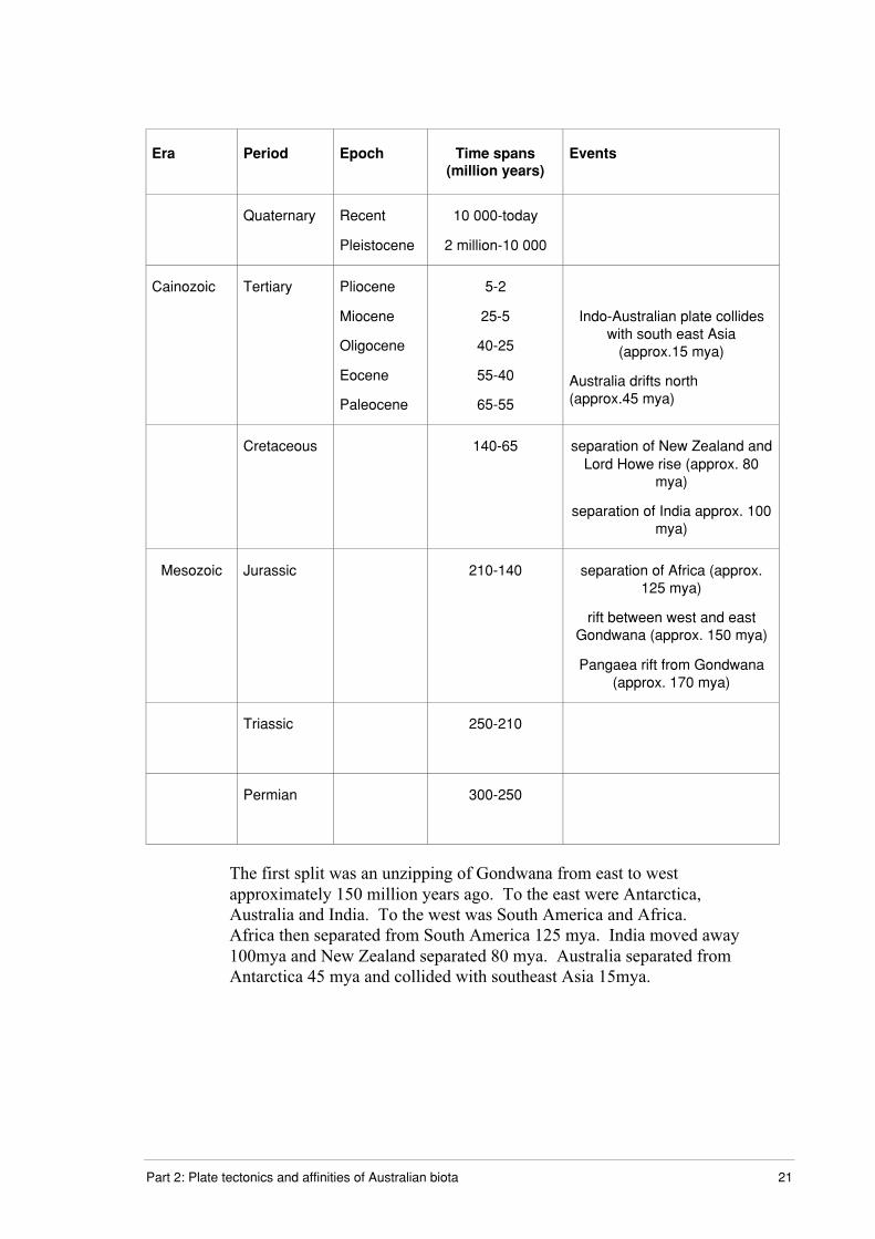
Era Period Epoch Time spans(million years)
Events
Quaternary Recent
Pleistocene
10 000-today
2 million-10 000
Cainozoic Tertiary Pliocene
Miocene
Oligocene
Eocene
Paleocene
5-2
25-5
40-25
55-40
65-55
Indo-Australian plate collideswith south east Asia
(approx.15 mya)
Australia drifts north(approx.45 mya)
Cretaceous 140-65 separation of New Zealand andLord Howe rise (approx. 80
mya)
separation of India approx. 100mya)
Mesozoic Jurassic 210-140 separation of Africa (approx.125 mya)
rift between west and eastGondwana (approx. 150 mya)
Pangaea rift from Gondwana(approx. 170 mya)
Triassic 250-210
Permian 300-250
The first split was an unzipping of Gondwana from east to westapproximately 150 million years ago. To the east were Antarctica,Australia and India. To the west was South America and Africa.Africa then separated from South America 125 mya. India moved away100mya and New Zealand separated 80 mya. Australia separated fromAntarctica 45 mya and collided with southeast Asia 15mya.

22 Evolution of Australian biota
Geological time line
Because geological time is so immense it is often difficult to conceive thelength between different periods. For that reason a timeline is a goodtool to help you to visualise time. In the Additional resources sectionthere is a timeline partially constructed for you. Use this or if you prefermake one yourself. The instructions for constructing your own are alsoin the Additional resources section.
Here is a list of the things which you should put on your time line, butdon’t limit yourself to the ones given (eg. you could note the time of theseparation of Africa and India, or the time India crashed into theEurasian plate):
Start at the Permian period (about 300 mya), when Australia was stillattached to the large supercontinent of Pangaea, through the separation ofGondwana and the progression of the separate Australian continent northuntil its collision with south-east Asia about 15 mya.
On the timeline mark:
• the important eras, periods and epochs (Permian, Triassic, Jurassic,cretaceous, tertiary, Quaternary
• separation of Gondwana from the rest of Pangaea
• separation of east (Antarctica, Australia, India) and west (SouthAmerica, Africa) Gondwana
• separation of New Zealand
• separation of Australia
• separation of south America
• Indo-Australian plate colliding with south-east Asia.
Note: you will need to refer to your notes and the Additional resources todo this exercise.
This exercise will help you to become familiar with the timing and namesof the geological periods and epochs, which aren’t easy to learn just ontheir own. All of the information you need to do this assignment are inthe learning material of this part, but if you like you can consult othersources such as books, CD ROMs or the Internet.
Two very useful references for this part may be available from yourlocal, school, or TAFE library or they could get them for you.
Part 2: Plate tectonics and affinities of Australian biota 23
• Lewis, G B. 1995. Plate Tectonics. Teacher Notes and StudentActivities. Australian Geological Survey. Geoscience EducationRecord.
• Lewis, G B. 1995. Time and Life. Geological time andPalaeontology. Teacher Notes and Student Activities. AustralianGeological Survey. Geoscience Education Record.
Complete Exercise 2.3. Send in your completed timeline.

24 Evolution of Australian biota
Part 2: Plate tectonics and affinities of Australian biota 25
Additional resources
Note: You can skip these steps and choose to use the prepared time linefollowing.
Instructions for making your own time line
You will need to either get some continuous paper (eg. unwaxed kitchenpaper or roll of wrapping paper) or stick A4 pages together.
How long a piece of paper will you need? Remember that the Earth isabout 4500 million years old but you don’t need to make your time lineto cope with that length of time. You should start your time line at thebeginning of the Permian Period (300-250 mya) when Australia was stillpart of the supercontinent of Pangaea. There are two ways of doing it:
Method 1
Decide how many years you will allocate to each unit of measurement ofyour line.
eg. 1 cm = 1 million years, your paper will need to be 3 m long
(300 cm = 3 m)
eg. 1 cm = 10 million years, your paper will need to be 0.3 m (30 cm)long (3000/10 cm = 30 cm = 0.3 m)
3 m might be a bit long to handle and 30 cm not long enough to fit thingsin, so you need to get something in between.
Method 2
Decide how long your paper is going to be and then work out how manymillions of years are represented by each unit of measurement.
You can use the following equation to work it out:
1 cm will = 300/(length of paper in metres x 100) million years

26 Evolution of Australian biota
If you decide that your paper will be 1.5 metres long then:
1 cm will = 300 / (1.5 m x 100)
= 300 / 150
= 2 million years
You now need to calculate the length of the period and then divide thisby the numbers of millions of years equivalent to 1 cm on your time line:
For example Permian period 300-250 mya = 50 million years
Distance on time line = 30/2 = 15.0 cm
Triassic period 250-210 mya = 40 million years
Distance on time line = 40/2 = 20cm
You will have to experiment a bit until you get a scale with which youare happy. The table following shows the main eras, periods and epochsalong with their time span. By the end of this module you should befamiliar with the order in which they occur and have some idea of howlong they were. This is pretty well impossible to do immediately, but bythe time you have worked through the learning materials and done theactivities and assignments of this module you will find that it isn’t toohard. It is a bit like learning a language other than your own native one.The more you make use of it the better you get.
Part 2: Plate tectonics and affinities of Australian biota 27
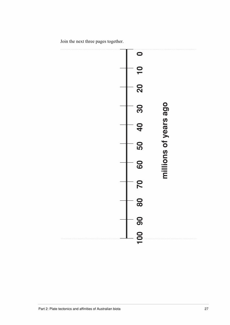
Join the next three pages together.
100
7080
9060
500
4030
2010
mill
ion
s o
f ye
ars
ago

28 Evolution of Australian biota
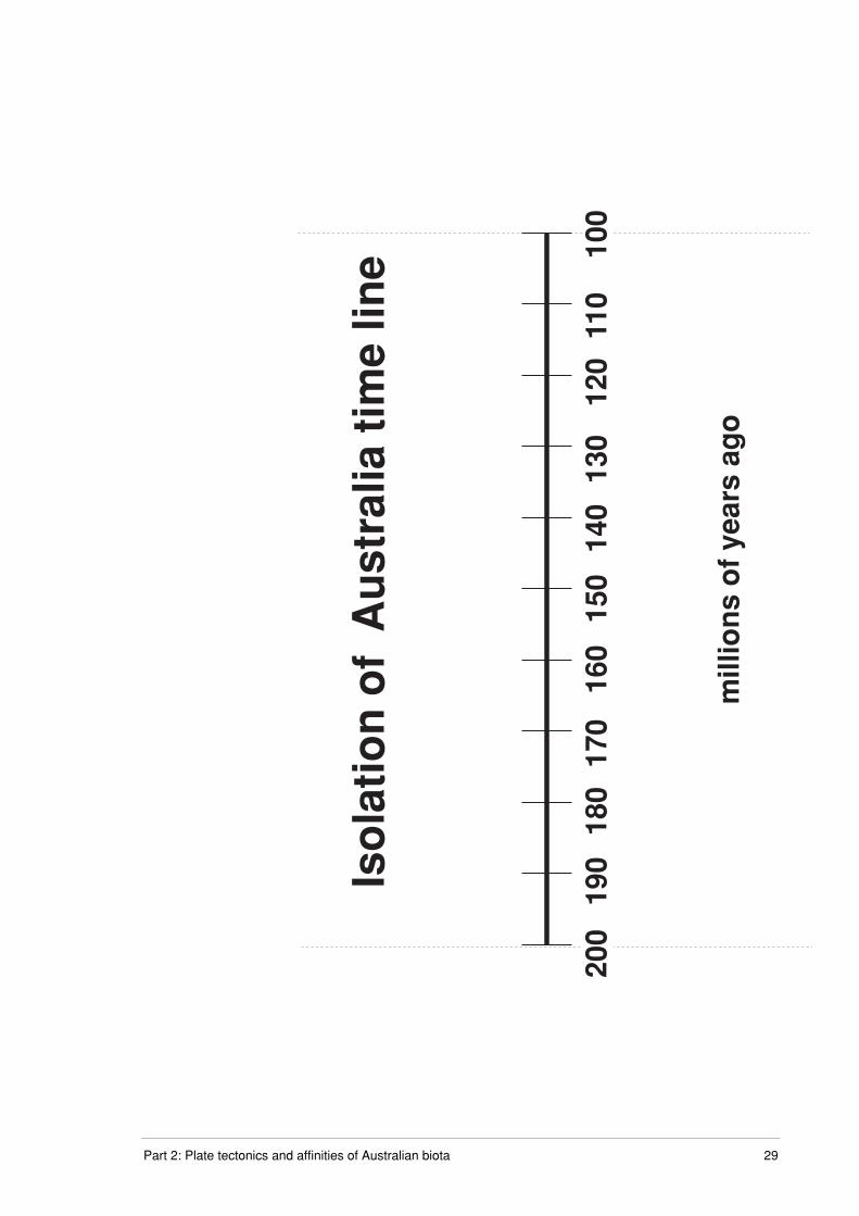
Part 2: Plate tectonics and affinities of Australian biota 29
200
170
180
190
160
150
100
140
130
120
110
mill
ion
s o
f ye
ars
ago
Iso
lati
on
of
Au
stra
lia t
ime
line

30 Evolution of Australian biota

Part 2: Plate tectonics and affinities of Australian biota 31
300
270
280
290
260
250
200
240
230
220
210
mill
ion
s o
f ye
ars
ago

32 Evolution of Australian biota
Part 2: Plate tectonics and affinities of Australian biota 33
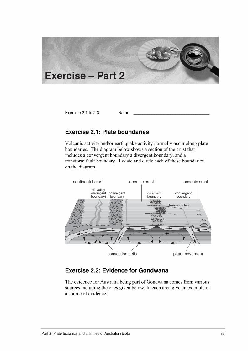
Exercise – Part 2
Exercise 2.1 to 2.3 Name: _________________________________
Exercise 2.1: Plate boundaries
Volcanic activity and/or earthquake activity normally occur along plateboundaries. The diagram below shows a section of the crust thatincludes a convergent boundary a divergent boundary, and atransform fault boundary. Locate and circle each of these boundarieson the diagram.
transform fault
rift valley(divergentboundary)
convergentboundary
divergentboundary
convergentboundary
continental crust oceanic crust oceanic crust
convection cells plate movement
Exercise 2.2: Evidence for Gondwana
The evidence for Australia being part of Gondwana comes from varioussources including the ones given below. In each area give an example ofa source of evidence.
34 Evolution of Australian biota
a) matching continent margins
______________________________________________________
______________________________________________________
______________________________________________________
______________________________________________________
______________________________________________________
b) position of mid-ocean ridges
______________________________________________________
______________________________________________________
______________________________________________________
______________________________________________________
______________________________________________________
c) spreading zones between continental plates
______________________________________________________
______________________________________________________
______________________________________________________
______________________________________________________
______________________________________________________
d) fossils in common on Gondwanan continents
______________________________________________________
______________________________________________________
______________________________________________________
______________________________________________________
______________________________________________________
e) similarities between present day organisms on Gondwanan
continents.
_________________________________________________________
_________________________________________________________
_________________________________________________________
_________________________________________________________
_________________________________________________________

Part 2: Plate tectonics and affinities of Australian biota 35
Exercise 2.3 : Timeline
Attach your completed time line and return to your teacher.


![[BIOTA CONVENTION]. PROGRAMMEbiotaph.org/wp-content/uploads/2012/04/BIOTA-CONVENTION-2012... · BIOTA Hymn Ateneo de Naga University Choir ... Bicol University 9:30 AM SNACK ... [BIOTA](https://static.documents.pub/doc/80x56/5b786cae7f8b9a7f378b8034/biota-convention-biota-hymn-ateneo-de-naga-university-choir-bicol-university.jpg)


