Exploiting Web Services for Meteorological Applications. Jozef Matula [email protected] IBL Software Engineering. Outline. What we do… Building forecasting application – what protocols/formats to use? IBL’s contribution to future MetOceanDWG interoperability experiments. My goal is…. - PowerPoint PPT Presentation
kshop on the Use of GIS/OGC standards in Meteorology, 23 rd -25 th Nov 2009, Toulouse, France Exploiting Web Services for Exploiting Web Services for Meteorological Applications Meteorological Applications Jozef Matula Jozef Matula [email protected][email protected]IBL Software Engineering IBL Software Engineering
Transcript
2nd Workshop on the Use of GIS/OGC standards in Meteorology, 23rd-25th Nov 2009, Toulouse, France
Exploiting Web Services for Exploiting Web Services for Meteorological ApplicationsMeteorological Applications
2nd Workshop on the Use of GIS/OGC standards in Meteorology, 23rd-25th Nov 2009, Toulouse, France
OutlineOutline
• What we do…
• Building forecasting application – what protocols/formats to use?
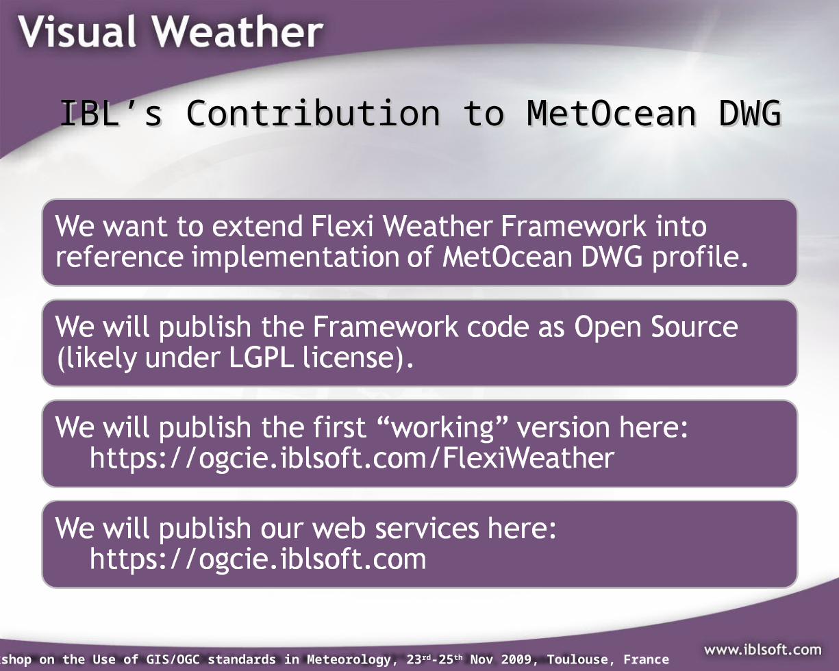
• IBL’s contribution to future MetOceanDWG interoperability experiments.
• My goal is…
…to get the REAL meteorological forecasting tool into my boss’ iPhone!
2nd Workshop on the Use of GIS/OGC standards in Meteorology, 23rd-25th Nov 2009, Toulouse, France
WHAT WE DO...WHAT WE DO...
2nd Workshop on the Use of GIS/OGC standards in Meteorology, 23rd-25th Nov 2009, Toulouse, France
What is IBL Visual Weather?What is IBL Visual Weather?
• Strategic Weather Information Forecasting Tool – UK Met Office project for workstation upgrade
• Visual Weather = Meteorological Workstation SW:– Met. data processing and visualisation– Interactive forecasting tools– Forecast production and workflow
management– Batch production– Extensibility with Python API– Web services (WMS, WCS, WFS, JMBL, Python)
• Everything in one box or Client-Server• Highly configurable and integration-capable
2nd Workshop on the Use of GIS/OGC standards in Meteorology, 23rd-25th Nov 2009, Toulouse, France
OGC Web Services in Visual WeatherOGC Web Services in Visual Weather
2nd Workshop on the Use of GIS/OGC standards in Meteorology, 23rd-25th Nov 2009, Toulouse, France
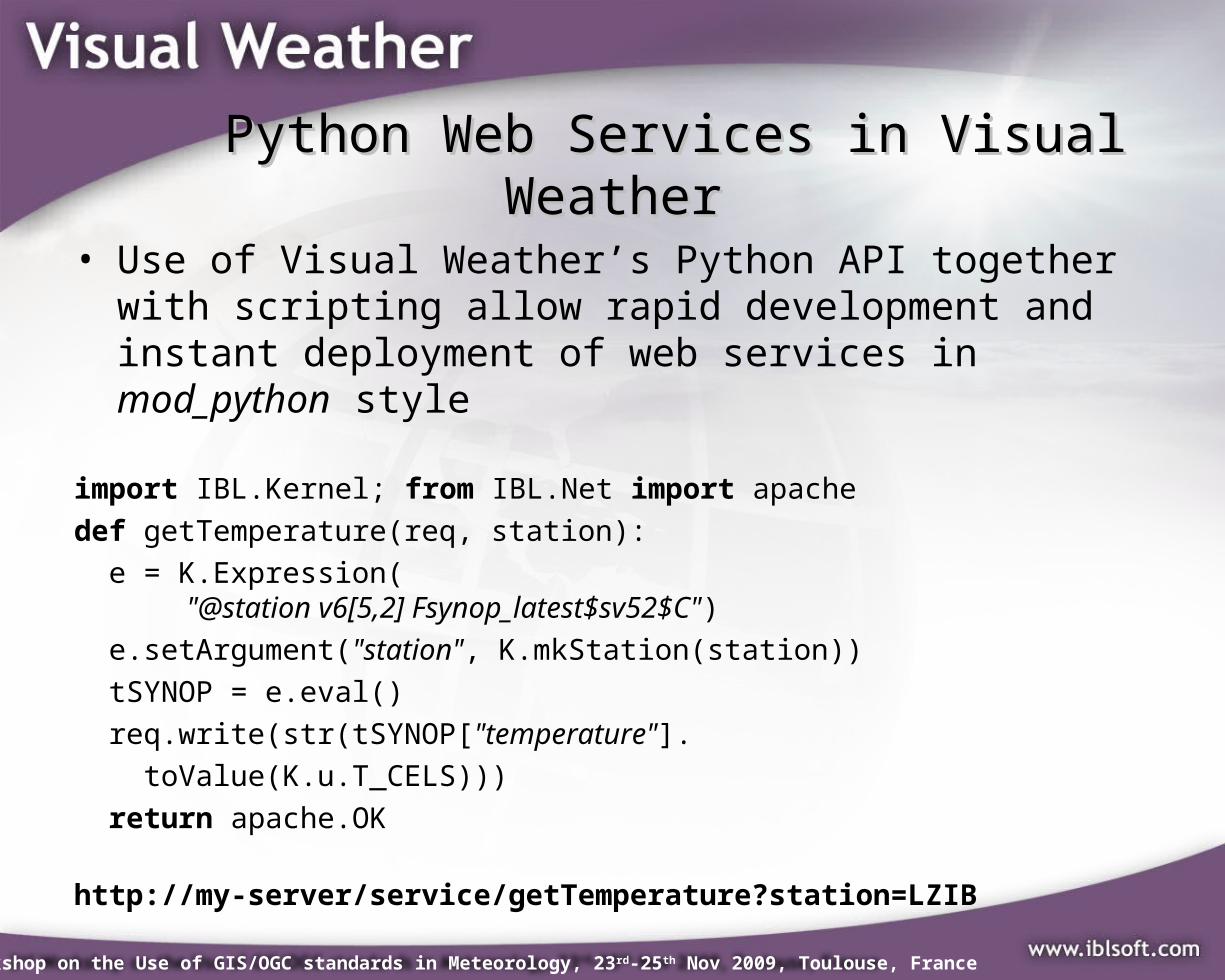
Python Web Services in Visual Python Web Services in Visual WeatherWeather
• Use of Visual Weather’s Python API together with scripting allow rapid development and instant deployment of web services in mod_python style
import IBL.Kernel; from IBL.Net import apache
def getTemperature(req, station):
e = K.Expression( "@station v6[5,2] Fsynop_latest$sv52$C")
2nd Workshop on the Use of GIS/OGC standards in Meteorology, 23rd-25th Nov 2009, Toulouse, France
The missing pieceThe missing piece
2nd Workshop on the Use of GIS/OGC standards in Meteorology, 23rd-25th Nov 2009, Toulouse, France
COMMON REQUIREMENTSCOMMON REQUIREMENTS
We decided to build a web 2.0 based forecasting workstation but what are the
http://www.projectcartoon.com/cartoon/63775
2nd Workshop on the Use of GIS/OGC standards in Meteorology, 23rd-25th Nov 2009, Toulouse, France
Decomposition of the met applicationDecomposition of the met application
2nd Workshop on the Use of GIS/OGC standards in Meteorology, 23rd-25th Nov 2009, Toulouse, France
How to meet requirements? (1)How to meet requirements? (1)
Synoptic map• Approx. 1500
observations in Europe (hourly)
• About 20 parameters needed
• WMS 100kB PNG• SOS/WFS 3MB GML:
– how to get time axis?
– complicated visualisation
• WCS ?
Miranda IM.lnk
2nd Workshop on the Use of GIS/OGC standards in Meteorology, 23rd-25th Nov 2009, Toulouse, France
How to meet requirements? (2)How to meet requirements? (2)Isolines from NWP
data• WMS this works –
tens of kBs.• WFS isoline could be
considered as feature• WCS
– Size effective output formats are hardly usable by simple clients
– Isolines algorithm is rather complicated.
2nd Workshop on the Use of GIS/OGC standards in Meteorology, 23rd-25th Nov 2009, Toulouse, France
How to meet requirements? (3)How to meet requirements? (3)
Meteograms & Cross-sections (graphs)
• WMS non-geospat. CRS
• SOS/WFS – tens of kB of GML
data– complexity of
visualisation depends on used client platform abilities
• WCS ?
2nd Workshop on the Use of GIS/OGC standards in Meteorology, 23rd-25th Nov 2009, Toulouse, France
How to meet requirements? (4)How to meet requirements? (4)
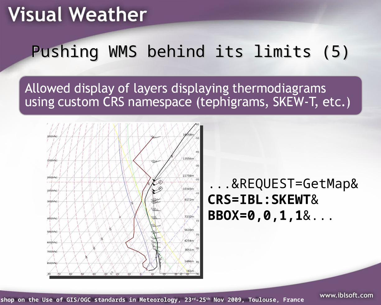
Thermodiagram (profile)• Single site• >5 parameters needed• WMS non-geospat.
CRS• SOS/WFS 10kB GML +
little bit of processing• WCS ?
– NWP profiles need hundreds MB of gridded data
• Size of image is approx. size of GML data.
Miranda IM.lnk
2nd Workshop on the Use of GIS/OGC standards in Meteorology, 23rd-25th Nov 2009, Toulouse, France
How to meet requirements? (5)How to meet requirements? (5)
Weather features• Single site• Tens of feature types
(single point or smooth polylines, text, areas)
• WMS Read only• WFS small GML, but
complicated visualisation.
• WCS no
2nd Workshop on the Use of GIS/OGC standards in Meteorology, 23rd-25th Nov 2009, Toulouse, France
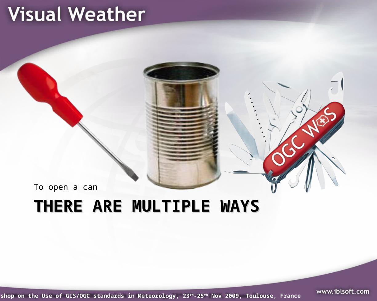
THERE ARE MULTIPLE WAYSTHERE ARE MULTIPLE WAYSTo open a can
2nd Workshop on the Use of GIS/OGC standards in Meteorology, 23rd-25th Nov 2009, Toulouse, France
Very simple conclusionsVery simple conclusions
2nd Workshop on the Use of GIS/OGC standards in Meteorology, 23rd-25th Nov 2009, Toulouse, France
Dummy MAPsDummy MAPs in in the the Web Web MAP MAP ServiceService
• Map is ONLY a picture so once you get a picture you usually loose:– Metadata – you don’t know what you got -
(time, content description, etc.)– Spatial localisation – (except formats like
GeoTIFF, JPEG2000)
• Map is a picture, that’s why anyone can work with it simply.
• Reference system of the image is CRS:1!
2nd Workshop on the Use of GIS/OGC standards in Meteorology, 23rd-25th Nov 2009, Toulouse, France
Pushing WMS behind its limits (1)Pushing WMS behind its limits (1)
TIME ISO8601DIM_RUN ISO8601DIM_FORECAST ISO8601 Duration or +XELEVATION Vertical level with unitDIM_STATION WMO station numberDIM_PLACE Place of time cross-section/meteogram: DIM_PLACE=EPSG:4326[1.5;43.7] DIM_PLACE=EPSG:54004[18627e3;4990e3] Horizontal route (space separated): DIM_PLACE=LZIB EPSG:4326[1;43] EHAM
2nd Workshop on the Use of GIS/OGC standards in Meteorology, 23rd-25th Nov 2009, Toulouse, France
GetMap with TIME dimension
HTML GetFeatureInfo with TIME
HTML empedded <img> GetMap with TIME & DIM_STATION
2nd Workshop on the Use of GIS/OGC standards in Meteorology, 23rd-25th Nov 2009, Toulouse, France
Pushing WMS behind its limits (3)Pushing WMS behind its limits (3)
...&REQUEST=GetMap&CRS=CRS:1&BBOX=0,0,639,479&...
2nd Workshop on the Use of GIS/OGC standards in Meteorology, 23rd-25th Nov 2009, Toulouse, France
Pushing WMS behind its limits (4)Pushing WMS behind its limits (4)