31


FS-0507A FEASIBILITY STUDY
Future I-73 Connector
From I-40 to the US 220-NC 68 Connector (R-2413) Greensboro, Guilford County
Division 7
I. General Description
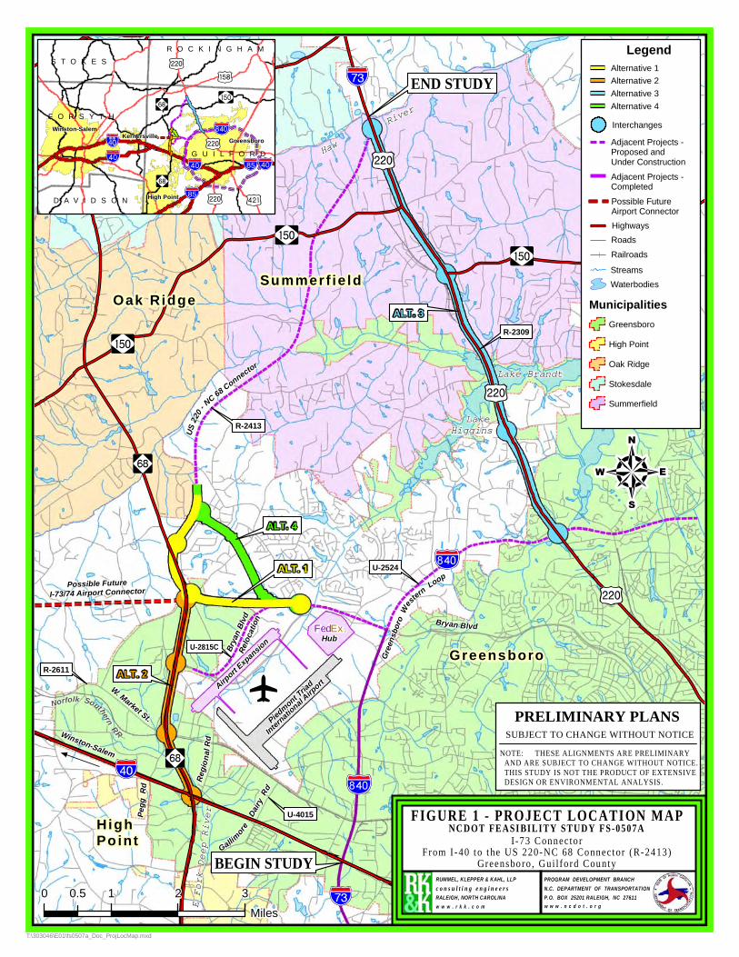
This feasibility study evaluates the routing of future Interstate 73 in western Greensboro from I-40 northward to the proposed US 220-NC 68 Connector (R-2413) where it joins existing US 220 near the Haw River. Four alternative routes for the future interstate are included. Alternative lengths vary from 2.5 to 7.5 miles. The lengths do not include portions along existing or proposed highways that do not require improvements. Entire study corridor lengths from I-40 to the Haw River range from 13.9 to 15.1 miles. Please see the attached Figure 1, Project Location Map.
The proposed typical section for the I-73 connector is a four-lane divided interstate freeway
with a 70’ median, full-depth paved shoulders, full control-of-access and service roads where required within a minimum state-maintained right-of-way of 350 feet. Some segments will require a six-lane section. All segments require wider 12’ paved shoulders because of anticipated heavy truck traffic.
This study is the initial step in the planning and design process for this project and is not the
product of exhaustive environmental or design investigations. The purpose of this study is to describe the proposed project, including costs, and to identify issues that may warrant more detailed study in the subsequent planning and design phases.
According to the Work Zone Safety and Mobility Policy this will be a significant project
because of traffic control issues and transportation network impacts. Future analysis is needed in the subsequent stages of the project to ensure that work zone impacts are identified and traffic management strategies are initiated.
II. Background
Improvements studied in this report are generated by the need to accommodate future Interstate 73 in Greensboro. The National Highway System’s “High Priority Corridor 5” (also referred to as the “I-73/74 North-South Corridor”) is defined by federal law as traveling from Georgetown, South Carolina to Sault Ste. Marie, Michigan. South Carolina and North Carolina have built sections of the corridor and Virginia has plans for building part of the corridor. SEC. 1105. HIGH PRIORITY CORRIDORS
NCDOT Feasibility Study FS-0507A Page 1 of 14

ON NATIONAL HIGHWAY SYSTEM from the Federal Highway Administration (FHWA) describes the I-73 route within NC as following: US 220 from the Virginia State line to NC State Route 68 in the vicinity of Greensboro; Route 68 to I-40; I-40 to US 220; US 220 in Greensboro to US 1 near Rockingham; and US 1 to the South Carolina State line. I-73 and I-74 run concurrently on US 220 through Asheboro. Additional route descriptions and mapping can be found on the FHWA website www.fhwa.dot.gov/hep10/nhs/hipricorridors/. The NCDOT has identified this future interstate corridor as a Strategic Highway Corridor (SHC). The potential interstate corridor can be found on Figure 2, SHC Vision Plan for the Triad Area, as adopted in September 2004. The route generally follows US 220 from the Virginia State line to the proposed US 220-NC 68 Connector (R-2413); the US 220-NC 68 Connector to NC 68; east on new location from NC 68 to the Bryan Blvd. relocation (U-2815); Bryan Blvd. to the I-840 Western Loop (U-2524); south on I-840 to I-40; I-40 east to US 220; and US 220 south to Asheboro and beyond. (This route most closely matches Study Alternatives 1 and 4.) The new location segment also has potential connections westward from the Piedmont Triad International (PTI) Airport to Winston-Salem. This future interstate corridor will also provide a critical connection to the greater Greensboro area from the north and the south. The Greensboro Urban Area Metropolitan Planning Organization (GUAMPO) has adopted plans to accommodate the potential routing of future Interstate 73 in western Greensboro. The GUAMPO Long Range Transportation Plan (LRTP) can be found on http://www.greensboro-nc.gov/departments/GDOT/divisions/planning/longrange/ . Freeway routes shown in the plans correspond closely to the potential interstate route on the NCDOT SHC Vision Plan described above. The plans also include future freeway connections to Winston-Salem. Potential routing plans were also developed in a Piedmont Triad International Airport Area Transportation Study completed in May 2004 by the NCDOT Transportation Planning Branch in cooperation with GUAMPO and other local organizations. The recommended alternative from that study follows the NCDOT SHC Vision Plan as described above. Their recommended alternative includes cutting off Bryan Blvd from the south for future I-73 to connect in to existing Bryan Blvd. The airport study also included a future east-west airport connector and other possible future system connections. A copy of the Piedmont Triad Airport Study Recommended Alternative is included in Figure 3 of this document. PTI Airport is experiencing significant growth and change. The main airport entryway is being relocated to the new Bryan Blvd./ Old Oak Ridge Road interchange in conjunction with the Bryan Blvd. relocation, the 3rd runway construction, and the FedEx Hub construction. Two of the FS-0507A study alternatives, Alternatives 1 and 4, connect directly to Bryan Blvd. near the airport’s new entryway. One of the study alternatives, Alternative 1, utilizes a ½-mile long property (presently
NCDOT Feasibility Study FS-0507A Page 2 of 14

Pleasant Ridge Golf Course) located between NC 68 and the Bryan Blvd./Old Oak Ridge Road interchange which the airport is preserving for possible use by the future interstate. Land use within the study area varies from residential and agricultural land north of the city to a mix of urban industrial, commercial, and office use within the city. A large tract of land between these areas is PTI Airport property. There is also potential institutional land use in the study area; the Guilford Technical Community College (GTCC) is considering locating a new campus northwest of NC 68 and Leaborne Road (see Figures 12 to 15). Federal, State, and Local plans classify the potential interstate route as future freeway and/or interstate. Adjoining routes I-40, U-2524 (I-840 Western Loop), U-2815 (Bryan Blvd. Relocation), and R-2413 (US 220-NC 68 Connector) are also classified as freeway/interstate routes. I-40 is a ten-lane interstate freeway within the study area. Other adjoining potential interstate routes are four- and six-lane freeways. State and Local plans classify existing highway US 220 as a principal arterial and a major thoroughfare, respectively. State highway classifications are shown on the NCDOT functional classification maps. Local classifications are taken from the GUAMPO Thoroughfare Plan. Other routes are classified as follows: NC 68 is classified as a minor arterial by the NCDOT and a freeway by GUAMPO. NC 150 is classified as a major collector by NCDOT and a major thoroughfare by GUAMPO. Pleasant Ridge Road (SR 2133) is classified as a minor collector by NCDOT and as a major thoroughfare by GUAMPO. West Market Street is classified as a major collector by NCDOT and a major thoroughfare by GUAMPO. There is a Norfolk Southern Railway which parallels West Market Street and crosses the potential interstate corridor. However, improvements considered in this study do not affect the railroad.
There are several NCDOT projects and studies listed in the Draft 2009-2015 Transportation Improvement Program (TIP) that are within or adjacent to the study area. Adjacent TIP projects and their relationship to the future interstate corridor can be seen on Figure 1.
TIP projects R-2309, R-2413, U-2524, and U-2815C directly affect alternatives considered in
this study. TIP project R-2309 proposes widening existing two-lane US 220 to a multi-lane curb-and-gutter facility with a narrow raised grass median from Horse Pen Creek Road (SR 2182) to the US 220-NC 68 Connector (R-2413). This portion of US 220 is part of a possible route for I-73. The R-2309 project does not propose full control of access and has many at-grade intersections. Proposed right-of-way varies from 120’ to 200’ wide. Right-of-way acquisition is expected to begin in 2008 and construction in 2010.
NCDOT Feasibility Study FS-0507A Page 3 of 14

TIP project R-2413 is the US 220-NC 68 Connector and is also part of a possible route for I-73.
It proposes a four-lane divided connector on new location with a 46’ median from NC 68 and Pleasant Ridge Road (SR 2133) to US 220 near the Haw River. This facility is to be constructed to interstate standards. Right-of-way acquisition is expected to begin in 2010 and construction in 2013. The 1992 Hearing Map design of the NC 68/Pleasant Ridge Road (SR 2133) interchange is currently being reevaluated to update the design, coordinate with future I-73, and coordinate with possible western connectors (see I-4924, FS-0707A and FS-0707B below).
TIP project U-2524 is the proposed Greensboro Western Urban Loop (future I-840) and
includes a new location freeway from south of I-40 to north of Bryan Blvd. (SR 2176). Portions of this project are included in the potential route for I-73. The portion from I-40 to Bryan Blvd. was opened to traffic on December 18th, 2007. The southwest portion from I-85 to I-40 and Bryan Blvd has been completed and was opened to traffic this spring. Completion of the portion north of Bryan Blvd is anticipated sometime after 2015.
TIP project U-2815C proposes relocating Bryan Blvd from Inman Road to NC 68. This project
is under construction by the airport authority and is in conjunction with the construction of a 3rd runway and a FedEx hub. Anticipated completion is mid 2008.
Future TIP project I-4924 and feasibility studies FS-0707A and FS-0707B will be directly
affected by the results of this study. Please also refer to Figure 3 in the back of this document. I-4924 is described as an I-73/74 Connector from the Winston-Salem Beltway north of Kernersville to NC 68 west of Greensboro. (It is also sometimes referred to as the Airport Connector.) The project is programmed for planning and environmental study only and is a candidate future NC Turnpike Authority project.
Proposed feasibility study FS-0707A will consider a new route from Sandy Ridge Road (SR 1850) at W. Market Street (SR 1008) to NC 68 near PTI Airport. The project may connect to the Alternative 1 or 4 I-73 route described in this document from the west.
Proposed feasibility study FS-0707B will consider a new route for a north-south freeway
connector from US 311 (future I-74) in High Point to NC 68 near PTI airport. The northern terminus of the project would connect to the Alternative 1 or 4 I-73 route described in this document .
TIP projects R-2611, U-4015, and U-5003 are part of this study’s adjacent roadway network.
R-2611 proposes widening West Market Street (SR 1008) to multi-lanes from NC 68 westward. U-4015 proposes widening Gallimore Dairy Road (SR 1556) to multi-lanes from NC 68 to I-40 and
NCDOT Feasibility Study FS-0507A Page 4 of 14
I-40 to W. Market Street. The part near I-40 is complete and the remaining part is unfunded. U-5003 proposes widening and grade separating Pegg Road (SR 1840)/Thatcher Road (SR 1842) over I-40. These projects will improve the roadway network in the study area but do not directly affect the improvements recommended in this study. III. Traffic & Safety
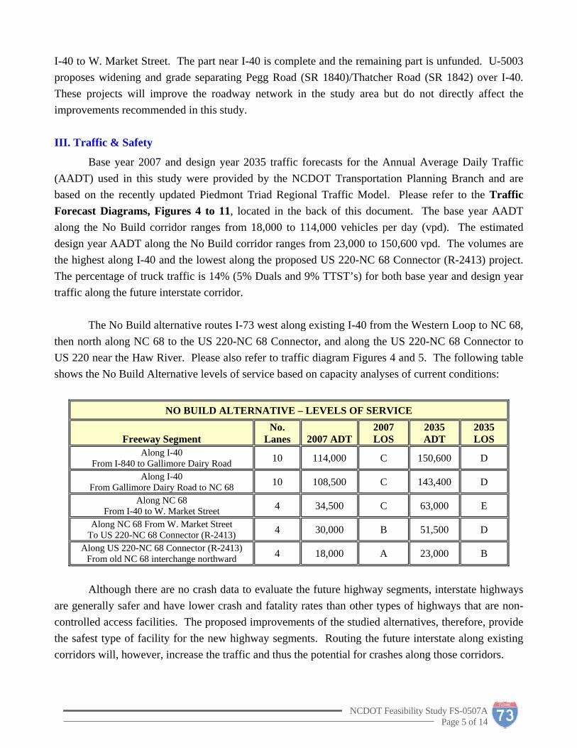
Base year 2007 and design year 2035 traffic forecasts for the Annual Average Daily Traffic (AADT) used in this study were provided by the NCDOT Transportation Planning Branch and are based on the recently updated Piedmont Triad Regional Traffic Model. Please refer to the Traffic Forecast Diagrams, Figures 4 to 11, located in the back of this document. The base year AADT along the No Build corridor ranges from 18,000 to 114,000 vehicles per day (vpd). The estimated design year AADT along the No Build corridor ranges from 23,000 to 150,600 vpd. The volumes are the highest along I-40 and the lowest along the proposed US 220-NC 68 Connector (R-2413) project. The percentage of truck traffic is 14% (5% Duals and 9% TTST’s) for both base year and design year traffic along the future interstate corridor. The No Build alternative routes I-73 west along existing I-40 from the Western Loop to NC 68, then north along NC 68 to the US 220-NC 68 Connector, and along the US 220-NC 68 Connector to US 220 near the Haw River. Please also refer to traffic diagram Figures 4 and 5. The following table shows the No Build Alternative levels of service based on capacity analyses of current conditions:
NO BUILD ALTERNATIVE – LEVELS OF SERVICE
Freeway Segment No.
Lanes 2007 ADT2007 LOS
2035 ADT
2035 LOS
Along I-40 From I-840 to Gallimore Dairy Road 10 114,000 C 150,600 D
Along I-40 From Gallimore Dairy Road to NC 68 10 108,500 C 143,400 D
Along NC 68 From I-40 to W. Market Street 4 34,500 C 63,000 E
Along NC 68 From W. Market Street To US 220-NC 68 Connector (R-2413) 4 30,000 B 51,500 D
Along US 220-NC 68 Connector (R-2413) From old NC 68 interchange northward 4 18,000 A 23,000 B
Although there are no crash data to evaluate the future highway segments, interstate highways
are generally safer and have lower crash and fatality rates than other types of highways that are non-controlled access facilities. The proposed improvements of the studied alternatives, therefore, provide the safest type of facility for the new highway segments. Routing the future interstate along existing corridors will, however, increase the traffic and thus the potential for crashes along those corridors.
NCDOT Feasibility Study FS-0507A Page 5 of 14

IV. Description of Alternatives
Improvements studied are generated by the need to accommodate future Interstate 73 in western Greensboro. Four alternatives are considered and described below:
Alternative 1 routes future I-73 from I-40 north along I-840 (U-2524) for 3.5 miles, west along
Bryan Boulevard (U-2815) for 1.5 miles, west-northwest on new location (as the proposed I-73 Connector) for 2.4 miles, and finally north along the US 220-NC 68 Connector (R-2413) to US 220 for 7.7 miles. Approximately 3 miles of construction is needed for this alternative. The complete study alternative is 15.1 miles long from I-40 to US 220. Please refer to Figure 12. The proposed typical section is a four-lane divided freeway with a 70’ median, 4’ full-depth median paved shoulders, and 12’ full-depth outside paved shoulders within a 350’ right-of-way.
The portion of Alternative 1 along the proposed Greensboro Western Loop (U-2524) is open to
traffic. The portion along the Bryan Boulevard Relocation project (U-2815C) is anticipated to be completed in 2008. Construction of the US 220-NC 68 Connector (R-2413 sections A and B) is anticipated to begin in year 2013. These projects are to be constructed to interstate standards.
The following table shows the anticipated Alternative 1 freeway segment levels of service in 2035:
ALTERNATIVE 1 – LEVELS OF SERVICE
Segment 2035 ADT Total No. Lanes 2035 LOS Along Western Loop (U-2524B)
From I-40 to Bryan Blvd 88,000 6 (existing) D Along Bryan Blvd (U-2815C)
From Loop to Old Oak Ridge Road interchange 78,000 6 (existing) D New Segment
From Old Oak Ridge Road interchange to NC 68 68,000 6 C New Segment
From NC 68 to US 220-NC 68 Connector (R-2413) 49,000 4 C Along US 220-NC 68 Connector (R-2413)
From old NC 68 interchange northward 36,000 4 (existing) C Alternative 1 improvements tie into the western Old Oak Ridge Road interchange ramps
(proposed under the U-2815 project) and proceed west on new location towards NC 68. No improvements are needed along the retained portions of I-840, Bryan Blvd., or the future US 220-NC 68 Connector. A six-lane section is needed between the Old Oak Ridge Road and NC 68 interchanges. Alternative 1 improvements include removing Pleasant Ridge Road from the freeway-to-freeway interchange needed for NC 68, the US 220-NC 68 Connector, I-73, and a future western connector. Pleasant Ridge Road can be relocated around the freeway-to-freeway interchange to the north and grade separated over the future interstate. The interchange configuration is designed to accommodate a future freeway link to the west, the “I-73/74 Airport Connector”, and is represented on the map. Access to NC 68 is provided in conjunction with the proposed US 220-NC 68 Connector
NCDOT Feasibility Study FS-0507A Page 6 of 14

(R-2413) improvements. The relocation of Pleasant Ridge Road will facilitate maintenance of traffic during construction.
It is anticipated that Alternative 1 will require the relocation of eight (8) residences and four (4) businesses. It is estimated that the scope of ITS deployment for Alternative 1 will include 4 CCTV’s, 2 DMS’s, 8 detection devices and 28,000 feet of fiber optic cable and will cost $ 2,100,000. The total cost, including ITS, construction, right-of-way, and utility relocations, is estimated to be $ 121,500,000.
Construction Right-of-Way Utility Relocations ITS Total $ 70,000,000 $ 49,000,000 $ 400,000 $ 2,100,000 $ 121,500,000
Alternative 2 routes future I-73 west along I-40 for 2.5 miles, north along NC 68 for 3.0 miles,
and finally north along the US 220-NC 68 Connector (R-2413) to US 220 for 9.3 miles. Approximately 3.5 miles of construction are needed for this alternative. The complete study alternative is 14.8 miles long from I-40 to US 220. Please refer to Figure 13. The proposed typical section is a four-lane divided freeway with a 46’ (existing) median, 4’ full-depth median paved shoulders, and 12’ full-depth outside paved shoulders within existing right-of-way.
The following table shows the anticipated Alternative 2 freeway segment levels of service in 2035:
ALTERNATIVE 2 – LEVELS OF SERVICE
Segment 2035 ADT Total No. Lanes 2035 LOS
Along I-40 From I-840 to Gallimore Dairy Road 150,100 10 (existing) D
Along I-40 From Gallimore Dairy Road to NC 68 143,400 10 (existing) D
Widened NC 68 From I-40 to W. Market Street 63,000 6 (widened from 4) C
Along NC 68 From W. Market Street To US 220-NC 68 Connector (R-2413) 51,500 4 (existing) D
Along US 220-NC 68 Connector (R-2413) From old NC 68 interchange northward 23,000 4 (existing) B
I-40 and NC 68 (south of Pleasant Ridge Road) levels of service will improve slightly with the
inclusion of a future western airport connector; i.e. more traffic is predicted to travel along Bryan Blvd to the Western Loop instead of down NC 68 to I-40 with a western airport connector in place.
Alternative 2 improvements include reconstructing the I-40/NC 68 interchange to a freeway-to-
freeway configuration, relocating the interchange ramps at W. Market Street to meet interstate standards, and installing interstate standard paved shoulders and median guiderail along NC 68. Based on the current traffic forecasts and I-40 improvements currently under construction, Alternative 2 improvements for the new NC 68/I-40 interchange ramps can be accomplished west of the Gallimore
NCDOT Feasibility Study FS-0507A Page 7 of 14

Dairy Road bridge. No improvements are needed along the portions of I-40 east of Gallimore Dairy Road or along the future US 220-NC 68 Connector.
Alternative 2 improvements include increasing the radii of the loop-ramps and providing proper
ramp terminal spacing at the W. Market Street interchange. Improvements also include installation of interstate standard paved shoulders, median cable guiderail and full control-of-access along NC 68 from I-40 to project R-2413. NC 68 will need to be widened from four to six lanes from I-40 to W. Market Street. Access control needed for the new I-40/NC 68 interchange will affect several existing at-grade intersections, require several access road relocations and affect at least one planned development site along NC 68.
It is anticipated that Alternative 2 will require the relocation of no (0) residences and thirty-three (33) businesses. It is estimated that the scope of ITS deployment for Alternative 2 will include 4 CCTV’s, 2 DMS’s, 8 detection devices and 33,000 feet of fiber optic cable and will cost $ 2,400,000. The total cost, including ITS, construction, right-of-way, and utility relocations, is estimated to be $ 160,900,000.
Construction Right-of-Way Utility Relocations ITS Total $ 54,300,000 $ 103,500,000 $ 700,000 $ 2,400,000 $ 160,900,000
Alternative 3 routes future I-73 from I-40 north along I-840 (U-2524) for 6.7 miles and north
along US 220 (R-2309) for 7.3 miles. Approximately 7.5 miles of construction is needed for this alternative. The complete study alternative is 14.0 miles long from I-40 to the Haw River. Please refer to Figure 14.
Alternative 3 improvements include significant reconstruction of the US 220 corridor from the
Western Loop north to where the US 220-NC 68 Connector (R-2413) joins existing US 220. Project R-2309 proposes widening this same segment of US 220 from a two-lane roadway to a four-lane divided roadway with a narrow raised grass median on right-of-way varying from 120’ to 200’ wide. The R-2309 project does not propose full control of access and has many at-grade intersections along the corridor. Upgrading the corridor to an interstate would include maintaining one side of the four-lane roadway as a service road and constructing the new interstate parallel to that roadway.
The proposed Alternative 3 typical section along the US 220 corridor is a four-lane divided
freeway with a 70’ median, 4’ full-depth median paved shoulders, 12’ full-depth outside paved shoulders within a 350’ right-of-way. Future I-73 would be constructed on alternating sides of the R-2309 multi-lane improvements in order to minimize impacts to existing development and maintain two lanes as a service road. Service Roads would be needed along both sides of the interstate for the whole length of construction along US 220 (R-2309).
NCDOT Feasibility Study FS-0507A Page 8 of 14

Alternative 3 improvements include new bridges over Lakes Brandt and Higgins, reconstructing two interchanges, constructing two new interchanges and two new grade separations. The interchange at the north end with the US 220-NC 68 Connector (R-2413) would be reconstructed to make I-73 the through movement. Reconstruction of the proposed Western Loop (I-840) interchange at US 220 from a SPUI to a freeway-to-freeway interchange would require substantial reconstruction and extensive bridging over wetlands.
Alternative 3 would result in significant human and natural environmental impacts and would
be the most expensive alternative to construct. It was determined that neither traffic capacity analyses nor cost estimates were necessary to further evaluate this alternative. Additional information on the impact of Alternative 3 is discussed in the subsequent sections of the document.
Alternative 4 routes future I-73 from I-40 north along I-840 (U-2524) for 3.5 miles, west along
Bryan Boulevard (U-2815) for 1.5 miles, northwest on new location (as the proposed I-73 Connector) for 2.5 miles, and finally north along the US 220-NC 68 Connector (R-2413) to US 220 for 6.4 miles. Approximately 2.5 miles of construction is needed for this alternative. The complete study alternative is 13.9 miles long from I-40 to US 220. Please refer to Figure 15.
The following table shows the anticipated Alternative 4 freeway segment levels of service in 2035:
ALTERNATIVE 4 – LEVELS OF SERVICE
Segment 2035 ADT Total No. Lanes 2035 LOS Along Western Loop (U-2524B)
From I-40 to Bryan Blvd 74,000 6 (existing) C Along Bryan Blvd (U-2815C)
From W. Loop to Old Oak Ridge Road interchange 57,000 6 (existing) C New Segment
From Old Oak Ridge Road interchange to (R-2413) 42,000 4 C Along US 220-NC 68 Connector (R-2413)
Northward 24,000 4 (existing) B
Alternative 4 is similar to Alternative 1 but travels more northwest on new location bypassing the proposed US 220-NC 68 Connector interchange with Pleasant Ridge Road and NC 68. Alternative 4 includes a combination of four proposed interchanges – a partial-clover interchange at Pleasant Ridge Road, a pair of 3-leg interchanges at the junction of R-2413 and I-73, and a partial cloverleaf interchange with a future I-73/74 Airport Connector. Additional construction along NC 68 would be needed with the inclusion of the future western Airport Connector interchange. The western connection can intersect NC 68 at grade in the interim. The combination of these four interchanges provides full movement to and from NC 68, Pleasant Ridge Road, a future Airport Connector, and I-73. No improvements are needed along the retained portions of I-840, Bryan Blvd., or the retained portion of the proposed US 220-NC 68
NCDOT Feasibility Study FS-0507A Page 9 of 14

Connector (R-2413). Traffic directions and highway signing associated with this alternative would be challenging.
It is anticipated that Alternative 4 will require the relocation of forty (40) residences and one (1) business. It is estimated that an ITS deployment for Alternative 4 will include 4 CCTV’s, 2 DMS’s, 8 detection devices and 28,000 feet of fiber optic cable and will cost $ 2,100,000. The total cost, including ITS, construction, right-of-way, and utility relocations, is estimated to be $ 107,900,000.
Construction Right-of-Way Utility Relocations ITS Total $ 83,500,000 $ 22,100,000 $ 200,000 $ 2,100,000 $ 107,900,000
V. Human and Natural Environment Issues
Since the major portion of Alternatives 1, 2, and 4 would travel along existing freeways, there would not be many natural or human environment impacts associated with their proposed improvements. There are no known wetland impacts or community issues associated with Alternative 1. Alternative 1 is within the Lake Brandt protected watershed but not within the critical watershed.
Several culverts would be constructed or extended with Alternative 2 improvements, but they would be in areas where the streams are already disturbed and within existing right-of-way. There are no known wetland impacts or community issues associated with Alternative 2. Alternative 2 is within the Lake Brandt protected watershed but not within the critical watershed.
Alternative 4 would fragment a portion of the residential community northeast of Pleasant Ridge Road and NC 68; local access would be constrained and the community surrounded on three sides by freeways. Alternative 4 would have some wetland and stream impacts and require several box culverts. Alternative 4 is within the Lake Brandt protected watershed but not within the critical watershed.
There would be significant human and natural environment impacts along the US 220 corridor associated with Alternative 3 improvements. Alternative 3 crosses the Lake Brandt/Higgins critical watershed, a historic district near the NC 150 West intersection, and endangered species habitats around the lakes (such as a Bald Eagle habitat). Each of these would be impacted by the conversion of US 220 to an interstate corridor. Accessibility to Greensboro Academy, the Center for Creative Leadership, Burr-Mill Park, two golf courses, several churches, the Summerfield Family Medical Practice, and all the residential neighborhoods would also be impacted. The reconstruction of the Greensboro Western Loop interchange with US 220 would incur additional wetland impacts. Please also refer to Figure 16, Environmental Features Map located in the back of this document.
NCDOT Feasibility Study FS-0507A Page 10 of 14

VI. Project Costs and Recommendations
Alternative 3 can be eliminated from further consideration because of its extensive impacts on the human and natural environments and its foreseen high costs. Alternative 3 would require significant reconstruction of 7 miles of the US 220 corridor to provide a full controlled-access freeway. Many direct and indirect impacts would be incurred on the human and natural environments. High costs would be incurred from new bridges over Lakes Brandt and Higgins and over wetlands at the I-840 interchange. Alternative 3 would certainly be the most expensive and have the most impacts of the alternatives included in this study. This study does not recommend Alternative 3 for the future route of I-73 in Greensboro. The remaining three routes, Alternatives 1, 2 and 4, are viable alternatives for future I-73 through Greensboro. Each requires relatively short lengths of construction, 2.5 to 3.5 miles, to connect this 15-mile segment of future I-73. Each is anticipated to achieve acceptable levels of service in design year 2035. Each is anticipated to have relatively few environmental impacts. The differences in these three alternatives lie in how they fit with the human environment, the highway system, and how much they cost. The following table shows the anticipated costs associated with these three study alternatives:
Table 5 – ALTERNATIVE COSTS
Alternative Construction
Cost Right-of-Way
Cost Utility Relocation
Cost ITS Cost Total Cost
1 $ 70,000,000 $ 49,000,000 $ 400,000 $ 2,100,000 $ 121,500,000
2 $ 54,300,000 $ 103,500,000 $ 700,000 $ 2,400,000 $ 160,900,000
4 $ 83,500,000 $ 22,100,000 $ 200,000 $ 2,100,000 $ 107,900,000 Alternative 1 best corresponds to plans and legislation adopted by the FHWA, the NCDOT, and GUAMPO. It also agrees with plans developed in the 2004 Triad International Airport Area Transportation Study. Alternative 1 provides the best overall system linkage with surrounding highways. The alternative is the most accommodating design for a future I-73/74 Airport Connector. It connects to the PTI Airport’s proposed entryway and utilizes the property preserved by the airport. Alternative 1 best coordinates with and utilizes improvements proposed by the US 220-NC 68 Connector project. Alternative 2 costs more than Alternatives 1 and 4 and does not provide the best fit for the surrounding human environment, highway system, or airport development. Several business towers and other commercial developments would be displaced by the Alternative 2 interchange at I-40/NC 68. Additional development along NC 68 is being planned that would be impacted by Alternative 2 improvements. Maintenance of traffic during construction would be challenging. Alternative 2 does not provide good system linkage with future east-west routes or the new PTI Airport entrance at the Old Oak Ridge Road interchange. Alternative 2 will require relocation of the W. Market Street interchange ramps
NCDOT Feasibility Study FS-0507A Page 11 of 14

and Brigham Road. Alternative 2 routes future interstate traffic along NC 68, which is not an interstate facility, and along I-40, which is already a 10-lane section; Alternatives 1 and 4 would help alleviate anticipated congestion in this area whereas Alternative 2 would increase traffic strain.
Alternative 4 is a viable alternative as it provides a more direct route for I-73. However, it does not correlate as well as Alternative 1 with a future freeway route to the west as shown in GUAMPO transportation plans. Alternative 4 does not utilize portions of the R-2413 project designed to accommodate future I-73. Alternative 4 would require the largest area of new right-of-way and have many more residential impacts than the other two alternatives. Alternative 4 isolates a portion of the residential community between NC 68 and I-73. Construction limits would extend further north on NC 68 than Alternative 1 or TIP project R-2413. Alternative 4 would be more challenging to sign and navigate than the other alternatives. Alternative 4 is anticipated to have more environmental impacts than Alternatives 1 or 2. No wetland impacts are anticipated with the other alternatives. Alternative 4 does not coordinate as well as Alternative 1 with airport development, nor does it utilize the ½-mile corridor currently preserved on airport property. Alternative 4 would, however, provide a viable route for future I-73.
The recommendation of this study is, therefore, that Alternatives 1 and 4 be considered for the future routing of I-73 through Greensboro. Alternative 4 is a viable alternative for consideration in the future planning stages of the project. The total project cost associated with Alternative 4 is $ 107,900,000. Alternative 1 is the best overall alternative considered in this study. The total project cost associated with Alternative 1 is $ 121,500,000.
VII. Additional Comments
It should be noted that a Feasibility Study is a preliminary document that is the initial step in the planning and design process for a candidate project. It is not the product of comprehensive environmental or design investigations. Once a candidate project is identified for funding in the TIP, the Feasibility Study is followed by a rigorous planning and design process that meets the requirements of the National Environmental Policy Act, where either an Environmental Impact Statement or an Environmental Assessment is done. An environmental screening was conducted for this study to determine possible occurrences of threatened or endangered species, stream and wetland impacts, and impacts to human development.
Coordination with adjacent projects and planned development will be critical to a successful
corridor alignment and should be maintained throughout the subsequent stages of this project.
GUAMPO and the Greensboro DOT support the recommendation of Alternative 1 as a viable future I-73 Connector. As received in a letter dated April 25, 2008, “In the opinion of the Planning department based on the currently available information, it appears that Alternate 1 is the most reasonable alternative route that is both relatively financially feasible (unlike Alt. 2) with minimal
NCDOT Feasibility Study FS-0507A Page 12 of 14

disruption to anticipated land use patterns west of the airport (unlike Alt. 4) by utilizing the most existing, higher capacity roadway infrastructure”.
VIII. Additional Studies
Two additional cost estimates were performed in order to provide a network of local roads around the Alternative 1 system interchange. Two additional proposed roads, Ring Road NE and Ring Road SW, have been included to provide better access to development south of Pleasant Ridge Road and east of NC 68 near the airport. The roads are not necessary for the function of Alternative 1 but would, in conjunction with existing Bryan Blvd. and the Pleasant Ridge Road relocation, provide a local roadway network surrounding the interchange. Please refer to Figure 12.
Ring Road NE connects to the remaining portion of existing Bryan Blvd. south of Alternative 1,
travels north across Caindale Drive, bridges over future I-73, and terminates at Pleasant Ridge Road. The typical section is a four-lane undivided roadway with 4’ paved shoulders on 150’ of right-of-way. Approximately 1.1 miles of construction is needed. Two box culverts are needed. It is anticipated that Alternative 1 Ring Road NE will not require the relocation of any residences or businesses. The total cost, including construction, right-of-way, and utility relocations, is estimated to be $ 11,200,000.
Construction Right-of-Way Utility Relocations Total $ 9,800,000 $ 1,300,000 $ 100,000 $ 11,200,000
Ring Road SW connects to existing Bryan Blvd. at NC 68, travels west-northwest on new location
to Brigham Road, travels north along existing Brigham Road, and terminates at Pleasant Ridge Road. The new location typical section is a four-lane divided roadway with a 23’ narrow raised grass median and 4’ outside paved shoulders on 150’ of right-of-way. Approximately 2,000 feet of new location construction is needed. The existing Bryan Blvd. interchange with NC 68 would be reconstructed into a partial-clover interchange with its ramps in the southern quadrants. Additional right-of-way (100’ total) and improved paved shoulders along 0.5 mile of Brigham Road are included as well. It is anticipated that Alternative 1 Ring Road SW will not require the relocation of any residences or businesses. The total cost, including construction, right-of-way, and utility relocations, is estimated to be $ 9,900,000.
Construction Right-of-Way Utility Relocations Total $ 8,500,000 $ 1,200,000 $ 200,000 $ 9,900,000
If included with Alternative 1, it is anticipated that Alternative 1 plus the Ring Roads would require the relocation of eight (8) residences and four (4) businesses and cost $ 142,600,000.
NCDOT Feasibility Study FS-0507A Page 13 of 14

NCDOT Feasibility Study FS-0507A Page 14 of 14
IX. Figures
Figure 1 - Project Location Map (with Adjacent Projects) Figure 2 - NCDOT Strategic Highway Corridors Vision Plan for the Triad Area Figure 3 - Piedmont Triad Airport Study Recommended Alternative Figures 4 thru 11 - Traffic Forecast Diagrams Figure 12 - Alternative 1 Map (with “Ring Roads”) Figure 13 - Alternative 2 Map Figure 14 - Alternative 3 Map Figure 15 - Alternative 4 Map Figure 16 - Environmental Features Map
Greensboro
Summerf ie ldOak Ridge
HighPoint
ALT. 1 U-2524
U-2815C
ALT. 2
R-2413
R-2309
ALT. 3
Bry
an B
lvd
Rel
oca
tion
Gre
ensb
oro
Wes
tern
Loop
W. Market St.
Winston-Salem
Possible Future
I-73/74 Airport Connector
ALT. 4
Airport
Expansion Hub
BEGIN STUDY
Lake Brandt
LakeHiggins
Haw
River
Bryan Blvd
US
220
- NC 68 C
onnector
Galli
mor
e
Dai
ry R
d
Reg
ion
al R
d
U-4015
R-2611
END STUDY
Norfolk Southern R
R
Pe
gg
R
d
FedExFedEx
Inte
rnatio
nal Airp
ort
Piedm
ont Tria
d
E Fo
rk D
eep Ri
ver
I-73 Connec to rFrom I -40 to t he US 220-NC 68 Connec tor (R-2413)
Greensboro , Gui l fo rd Coun ty
FIGURE 1 - PROJECT LOCATION MAP
Winston-Salem
High Point
KernersvilleGreensboro
S T O K E S
R O C K I N G H A M
F O R S Y T H
G U I L F O R D
D A V I D S O N
0 1 2 30.5Miles
RUMMEL, KLEPPER & KAHL, LLP
c o n s u l t i n g e n g i n e e r sPROGRAM DEVELOPMENT BRANCH
N.C. DEPARTMENT OF TRANSPORTATION
P.O. BOX 25201 RALEIGH, NC 27611
w w w . r k k . c o m
T:\303046\E01\fs0507a_Doc_ProjLocMap.mxd
Legend
Municipalities
High Point
Oak Ridge
Stokesdale
Summerfield
Roads
Adjacent Projects - Proposed and Under Construction
Alternative 4Alternative 3Alternative 2Alternative 1
Possible Future Airport ConnectorHighways
StreamsWaterbodies
Interchanges
Greensboro
PRELIMINARY PLANSSUBJECT TO CHANGE WITHOUT NOTICE
NOTE: THESE ALIGNMENTS ARE PRELIMINARY AND ARE SUBJECT TO CHANGE WITHOUT NOTICE. THIS STUDY IS NOT THE PRODUCT OF EXTENSIVE DESIGN OR ENVIRONMENTAL ANALYSIS.
RALEIGH, NORTH CAROLINA
w w w . n c d o t . o r g
Railroads
Adjacent Projects - Completed
NCDOT FEASI BILITY STUDY F S-0507A

FS
-0
50
7A
Fi
gu
re
2

Prep
ared
by:
Tra
nspo
rtat
ion
Plan
ning
Bra
nch
E
nviro
nmen
t, Pl
anni
ng, a
nd L
ocal
Gov
ernm
ent A
ffairs
Nor
th C
arol
ina
Dep
artm
ent o
f Tra
nspo
rtat
ion
In C
oope
ratio
n w
ith:
P
iedm
ont A
utho
rity
for R
egio
nal T
rans
port
atio
n
Gre
ensb
oro
Urb
an A
rea
MPO
Hig
h Po
int U
rban
Are
a M
PO
W
into
n Sa
lem
Are
a M
PO
G
uilfo
rd C
ount
y Pl
anni
ng D
epar
tmen
t
Pie
dmon
t Tria
d In
tern
atio
nal A
irpor
t
Fed
eral
Hig
hway
Adm
inis
trat
ion
U
.S. D
epar
tmen
t of T
rans
port
atio
n
May
, 200
4
Sc
ott W
. Wal
ston
, P.E
.
Tran
spor
tatio
n Pl
anni
ng B
ranc
h Pr
ojec
t Eng
inee
r
FS-0
507A
Fig
ure
3

PROJECT:
Construct a freeway
LOCATION:
I-73 from Greensboro Western Loop to NC68
Connector
(d, t
)PM
DD
HV
L E
G E
N D
###
No.
of V
ehic
les
Per
Day
(vpd
) in
100s
1-Le
ss th
an 1
00 v
pd
###
DH
VPM D ( d
, t )
Des
ign
Hou
rly V
olum
e (%
) = K
30PM
Pea
k Pe
riod
Peak
Hou
r Dire
ctio
nal S
plit
(%)
Indi
cate
s D
irect
ion
of D
Dua
ls, T
T-ST
s (%
)
Turn
ing
volu
me
(vpd
)
CO
UN
TY:
Gui
lford
DIV
. : 7
TIP:
FS-
0507
AW
BS:
344
18.1
.4
DA
TE:
08-2
0-20
07Pr
epar
ed b
y E.
Tal
anke
r
250
95 50300
128
160
100
67
9060 115
110
NO
BU
ILD
Futu
re I-
73 fo
llow
s N
C68
from
I-40
, A
irpor
t C
onne
ctor
to
NC
68 is
not
in p
lace
, con
nect
or
to W
inst
on-S
alem
is n
ot in
pla
ce
SR21
76 -
Bry
an B
lvd
SR21
76 -
Bry
an B
lvd
2007
EST
IMA
TED
AA
DT
300
345
375
224
450
SR15
56 -
Gal
limor
e D
airy
Rd
475
PM60
10(4
,3)
280
PM60
10(4
,3)
250
PM60
10(5
,9)
1085
PM60
10(5
,9)
1020
160
230
PM
6010
(5,9)
1140
PM60
10(5,9)
730
SR20
85 -
Rel
ocat
ed B
ryan
Blv
d45 115
470
PM55
10(4
,3)
95180
4090 70
105
SR10
08-
W. M
arke
t Str
eet
185
200
40
68SR
1556
-G
allim
ore
Dai
ry R
d
8560 95
45
225
190
840
68
SR21
33 -
Plea
sant
Rid
ge R
oad
SR21
33 -
Plea
sant
Rid
ge R
oad
145
200
PM60
10(3
,2)
235
8350
8058
75
20
SR10
08-
W. M
arke
t Str
eet
40
PM11
60(4
,3)
PM11
60(4
,3)
PM60
10(3
,2)
40
40
73
Future
73
Future
40
840
73
Future
Gre
ensb
oro
Wes
tern
Loop
(U
-252
4)
Fi
gu
re
4F
S-
05
07
A

PROJECT:
Construct a freeway
LOCATION:
I-73 from Greensboro Western Loop to NC68
Connector
(d, t
)PM
DD
HV
L E
G E
N D
###
No.
of V
ehic
les
Per
Day
(vpd
) in
100s
1-Le
ss th
an 1
00 v
pd
###
DH
VPM D ( d
, t )
Des
ign
Hou
rly V
olum
e (%
) = K
30PM
Pea
k Pe
riod
Peak
Hou
r Dire
ctio
nal S
plit
(%)
Indi
cate
s D
irect
ion
of D
Dua
ls, T
T-ST
s (%
)
Turn
ing
volu
me
(vpd
)
CO
UN
TY:
Gui
lford
DIV
. : 7
TIP:
FS-
0507
AW
BS:
344
18.1
.4
DA
TE:
08-2
0-20
07Pr
epar
ed b
y E.
Tal
anke
r
390
140
115
455
240
266
172
109
160
125
145
220
NO
BU
ILD
Fu
ture
I-73
follo
ws
NC
68 fr
om I-
40,
Airp
ort
Con
nect
or t
o N
C68
is n
ot in
pla
ce, c
onne
ctor
to
Win
ston
-Sal
em is
not
in p
lace
SR21
76 -
Bry
an B
lvd
SR21
76 -
Bry
an B
lvd
2035
EST
IMA
TED
AA
DT
515
630
550
405
630
SR15
56 -
Gal
limor
e D
airy
Rd
700
PM60
10(4
,3)
490
PM
6010
(4,3)
380
1434
1345
340
355
1506
916
SR20
85 -
Rel
ocat
ed B
ryan
Blv
d90 250
660
PM
5510
(4,3)
205
230
7580 105
165
SR10
08-
W. M
arke
t Str
eet
370
315
40
68
73
Future
40
SR15
56 -
Gal
limor
e D
airy
Rd
90110
115
55
314
330
73
Future
840
73
Future
68
SR21
33 -
Plea
sant
Rid
ge R
oad
SR21
33 -
Plea
sant
Rid
ge R
oad
195
305
PM
5510
(4,3)
PM
5510
(4,3)
315
138
70
105
63
145
60
SR10
08-
W. M
arke
t Str
eet
40
PM11
55(5,9)
PM
1155
(5,9)
Gre
ensb
oro
Wes
tern
Loop
(U
-252
4)
PM
6010
(5,9)
PM
6010
(5,9)
PM60
10(5,9)
PM60
10(5,9)
Fi
gu
re
5F
S-
05
07
A

PROJECT:
Construct a freeway
LOCATION:
I-73 from Greensboro Western Loop to NC68
Connector
(d, t
)PM
DD
HV
L E
G E
N D
###
No.
of V
ehic
les
Per
Day
(vpd
) in
100s
1-Le
ss th
an 1
00 v
pd
###
DH
VPM D ( d
, t )
Des
ign
Hou
rly V
olum
e (%
) = K
30PM
Pea
k Pe
riod
Peak
Hou
r Dire
ctio
nal S
plit
(%)
Indi
cate
s D
irect
ion
of D
Dua
ls, T
T-ST
s (%
)
Turn
ing
volu
me
(vpd
)
CO
UN
TY:
Gui
lford
DIV
. : 7
TIP:
FS-
0507
AW
BS:
344
18.1
.4
DA
TE:
08-2
0-20
07Pr
epar
ed b
y E.
Tal
anke
r
Alte
rnat
ive
1
Futu
re I-
73 fo
llow
s G
reen
sbor
o W
este
rn L
oop
and
Airp
ort C
onne
ctor
to N
C68
with
the
Con
nect
or to
Win
ston
-Sal
em in
pla
ce
SR21
76 -
Bry
an B
lvd
2007
EST
IMA
TED
AA
DT
165
135
40210
170
124
30204
Gre
ensb
oro
Wes
tern
Loop
(U
-252
4)
SR21
76 -
Bry
an B
lvd
525
575
525
PM
5510
(5,9)
570
PM
6010
(4,3)
350
465
PM60
10(5
,9)
980
PM60
10(5
,9)
780
7598 90
6368148
125
41
30 25
Futu
re A
irpor
t Con
nect
orto
Win
ston
-Sal
em
210
260
240
215
PM60
10(5
,9)
990
PM60
10(5
,9)
940
55
265
524
360
SR20
85 -
Rel
ocat
ed B
ryan
Blv
d (U
-281
5)
(R-2
413)
140
175
115
25
SR21
37 -
Old
Oak
Rid
ge R
d
SR21
37 -
Old
Oak
Rid
ge R
d F
edEX
acc
ess
Airp
ort a
cces
s
70108
174
40
840
68
6873
Future
73
Future
40
73
Future
SR21
33 -
Plea
sant
Rid
ge R
oad
SR21
33 -
Plea
sant
Rid
ge R
oad
110
260
40
40
FIG
UR
E 1
4028
2
50
14
826
64
PM55
10(3
,1)
PM11
60( 3
,2 )
PM11
60( 3
,2 )
PM60
10(5
,9)
PM60
10(5
,9)
Fi
gu
re
6F
S-
05
07
A

PROJECT:
Construct a freeway
LOCATION:
I-73 from Greensboro Western Loop to NC68
Connector
(d, t
)PM
DD
HV
L E
G E
N D
###
No.
of V
ehic
les
Per
Day
(vpd
) in
100s
1-Le
ss th
an 1
00 v
pd
###
DH
VPM D ( d
, t )
Des
ign
Hou
rly V
olum
e (%
) = K
30PM
Pea
k Pe
riod
Peak
Hou
r Dire
ctio
nal S
plit
(%)
Indi
cate
s D
irect
ion
of D
Dua
ls, T
T-ST
s (%
)
Turn
ing
volu
me
(vpd
)
CO
UN
TY:
Gui
lford
DIV
. : 7
TIP:
FS-
0507
AW
BS:
344
18.1
.4
DA
TE:
10-0
5-20
07Pr
epar
ed b
y E.
Tal
anke
r
Alte
rnat
ive
1 Fu
ture
I-73
follo
ws
Gre
ensb
oro
Wes
tern
Loo
p an
d A
irpor
t Con
nect
or to
NC
68 w
ith th
e C
onne
ctor
to W
inst
on-S
alem
in p
lace
SR21
76 -
Bry
an B
lvd
2035
ES
TIM
ATE
D A
AD
T
269
205
120
308
308
173
118
293
Gre
ensb
oro
Wes
tern
Loop
(U
-252
4)
SR21
76 -
Bry
an B
lvd
750
880
754
PM60
10(5
,9)
780
PM60
10(4
,3)
470
680
1200
948
115
153
110
8890336
159
52
60 50
Futu
re A
irpor
t Con
nect
orto
Win
ston
-Sal
em
340
477
407
350
1345
1280
PM55
10(3
,1)
110
490
680
470
SR20
85 -
Rel
ocat
ed B
ryan
Blv
d (U
-281
5)
(R-2
413)
270
360
200
70
SR21
37 -
Old
Oak
Rid
ge R
d
SR21
37 -
Old
Oak
Rid
ge R
d F
edEX
acc
ess
Airp
ort a
cces
s
114
142
260
40
840
68
6873
Future
73
Future
40
73
Future
SR21
33 -
Plea
sant
Rid
ge R
oad
SR21
33 -
Plea
sant
Rid
ge R
oad
160
360
40
40
FIG
UR
E 2
PM11
60( 3
,2 )
PM11
60( 3
,2 )
PM60
10(5
,9)
PM60
10(5
,9)
4874
652149
24
4040
PM60
10(5
,9)
PM60
10(5
,9)
PM60
10(5
,9)
PM60
10(5
,9)
Fi
gu
re
7F
S-
05
07
A

PROJECT:
Construct a freeway
LOCATION:
I-73 from Greensboro Western Loop to NC68
Connector
(d, t
)PM
DD
HV
L E
G E
N D
###
No.
of V
ehic
les
Per
Day
(vpd
) in
100s
1-Le
ss th
an 1
00 v
pd
###
DH
VPM D ( d
, t )
Des
ign
Hou
rly V
olum
e (%
) = K
30PM
Pea
k Pe
riod
Peak
Hou
r Dire
ctio
nal S
plit
(%)
Indi
cate
s D
irect
ion
of D
Dua
ls, T
T-ST
s (%
)
Turn
ing
volu
me
(vpd
)
CO
UN
TY:
Gui
lford
DIV
. : 7
TIP:
FS-
0507
AW
BS:
344
18.1
.4
DA
TE:
08-2
0-20
07Pr
epar
ed b
y E.
Tal
anke
r
170
129
45204
7598 90
63
169
118
30196
Alte
rnat
ive
2 B
UIL
DFu
ture
I-73
follo
ws
NC
68 fr
om I-
40,
Airp
ort
Con
nect
or t
o N
C68
is n
ot in
pla
ce, c
onne
ctor
to
Win
ston
-Sal
em is
not
in p
lace
SR21
76 -
Bry
an B
lvd
SR21
76 -
Bry
an B
lvd
2007
EST
IMA
TED
AA
DT
250 260
525
240
464
SR15
56 -
Gal
limor
e D
airy
Rd
524
PM
6010
(4,3)
565
PM
6010
(4,3)
348
PM
6010
(5,.9)
990
PM
6010
(5,9)
940
500
265
980
780
SR20
85 -
Rel
ocat
ed B
ryan
Blv
d127
140
574
PM
5510
(5,9)
140
175
5080 65
75
SR10
08-
W. M
arke
t Str
eet
155
185
40
68
73
Future
40
SR15
56 -
Gal
limor
e D
airy
Rd
8560 95
45
225
190
73
Future
840
73
Future
68
SR21
33 -
Plea
sant
Rid
ge R
oad
SR21
33 -
Plea
sant
Rid
ge R
oad
160
215
PM
5510
(4,3)
PM
5510
(4,3)
300
8565
110
75
115
25
SR10
08-
W. M
arke
t Str
eet
40
PM
1155
(4,3)
PM11
55(4,3)
FIG
UR
E 3
Futu
re A
irpor
t Con
nect
orto
Win
ston
-Sal
em335
PM
5510
(5,9)
3765
PM60
10(5
,9)
PM60
10(5
,9)G
reen
sbor
o W
este
rnLo
op
(U-2
524)
Fi
gu
re
8F
S-
05
07
A

PROJECT:
Construct a freeway
LOCATION:
I-73 from Greensboro Western Loop to NC68
Connector
(d, t
)PM
DD
HV
L E
G E
N D
###
No.
of V
ehic
les
Per
Day
(vpd
) in
100s
1-Le
ss th
an 1
00 v
pd
###
DH
VPM D ( d
, t )
Des
ign
Hou
rly V
olum
e (%
) = K
30PM
Pea
k Pe
riod
Peak
Hou
r Dire
ctio
nal S
plit
(%)
Indi
cate
s D
irect
ion
of D
Dua
ls, T
T-ST
s (%
)
Turn
ing
volu
me
(vpd
)
CO
UN
TY:
Gui
lford
DIV
. : 7
TIP:
FS-
0507
AW
BS:
344
18.1
.4
DA
TE:
08-2
0-20
07Pr
epar
ed b
y E.
Tal
anke
r
292
198
117
343
102
158
107
83
336
157
146
277
Alte
rnat
ive
2 B
UIL
DFu
ture
I-73
follo
ws
NC
68 fr
om I-
40,
Airp
ort
Con
nect
or t
o N
C68
is n
ot in
pla
ce, c
onne
ctor
to
Win
ston
-Sal
em is
not
in p
lace
SR21
76 -
Bry
an B
lvd
SR21
76 -
Bry
an B
lvd
2035
EST
IMA
TED
AA
DT
430
480
750
410
680
SR15
56 -
Gal
limor
e D
airy
Rd
770
PM
6010
(5,9)
780
PM
6010
(5,9)
470
PM
6010
(5,9)
1380
PM60
10(5,9)
1300
660
402
1295
975
SR20
85 -
Rel
ocat
ed B
ryan
Blv
d172
214
800
PM
5510
(4,3)
275
360
7597 115
107
SR10
08-
W. M
arke
t Str
eet
250
280
40
68
73
Future
40
SR15
56 -
Gal
limor
e D
airy
Rd
90110
115
55
314
330
73
Future
840
73
Future
68
SR21
33 -
Plea
sant
Rid
ge R
oad
SR21
33 -
Plea
sant
Rid
ge R
oad
215
300
PM
5510
(4,3)
PM
5510
(4,3)
455
108
81
150
92
185
90
SR10
08-
W. M
arke
t Str
eet
40
PM11
55(5,9)
PM
1155
(5,9)
FIG
UR
E 4
Futu
re A
irpor
t Con
nect
orto
Win
ston
-Sal
em468
PM
5510
(4,3)
104
90
Gre
ensb
oro
Wes
tern
Loop
(U
-252
4)
PM60
10(5
,9)
PM60
10(5
,9)
Fi
gu
re
9F
S-
05
07
A

PROJECT:
Construct a freeway
LOCATION:
I-73 from Greensboro Western Loop to NC68
Connector
(d, t
)PM
DD
HV
L E
G E
N D
###
No.
of V
ehic
les
Per
Day
(vpd
) in
100s
1-Le
ss th
an 1
00 v
pd
###
DH
VPM D ( d
, t )
Des
ign
Hou
rly V
olum
e (%
) = K
30PM
Pea
k Pe
riod
Peak
Hou
r Dire
ctio
nal S
plit
(%)
Indi
cate
s D
irect
ion
of D
Dua
ls, T
T-ST
s (%
)
Turn
ing
volu
me
(vpd
)
CO
UN
TY:
Gui
lford
DIV
. : 7
TIP:
FS-
0507
AW
BS:
344
18.1
.4
DA
TE:
08-2
0-20
07Pr
epar
ed b
y E.
Tal
anke
r
Alte
rnat
ive
4
Futu
re I-
73 fo
llow
s G
reen
sbor
o W
este
rn L
oop
and
Bria
n B
lvd
to N
C68
/US2
20 C
onne
ctor
, w
ithou
t the
Con
nect
or to
Win
ston
-Sal
em
SR21
76 -
Bry
an B
lvd
2007
ES
TIM
ATE
D A
AD
T
250
114
103
211
7462 104
147
Gre
ensb
oro
Wes
tern
Loop
(U
-252
4)
SR21
76 -
Bry
an B
lvd
395
530
480
PM60
10(5,9)
330
PM60
10(4,3)
275
510
980
736
120
69 7049
30 25
250
295
225
255
990
1020
PM55
10(3,1)
55SR
2085
-R
eloc
ated
Bry
an B
lvd
(U-2
815)
120
145
SR21
37 -
Old
Oak
Rid
ge R
d
SR21
37 -
Old
Oak
Rid
ge R
d F
edEX
acc
ess
Airp
ort a
cces
s
258
108
160
40
840
68
68
73
Future
40
73
Future
SR21
33 -
Plea
sant
Rid
ge R
oad
SR21
33 -
Plea
sant
Rid
ge R
oad
200
7450
85
73
Future
132
7144
111
33180
40
40
70
PM
6010
(5,9)
54PM
6010
(4,3)
PM
6010
(4,3)
FIG
UR
E 5
PM60
10(5
,9)
PM60
10(5
,9)
PM60
10(5
,9)
PM60
10(5
,9)
248
261038
7214
28
255
Fi
gu
re
10
FS
-0
50
7A

PROJECT:
Construct a freeway
LOCATION:
I-73 from Greensboro Western Loop to NC68
Connector
(d, t
)PM
DD
HV
L E
G E
N D
###
No.
of V
ehic
les
Per
Day
(vpd
) in
100s
1-Le
ss th
an 1
00 v
pd
###
DH
VPM D ( d
, t )
Des
ign
Hou
rly V
olum
e (%
) = K
30PM
Pea
k Pe
riod
Peak
Hou
r Dire
ctio
nal S
plit
(%)
Indi
cate
s D
irect
ion
of D
Dua
ls, T
T-ST
s (%
)
Turn
ing
volu
me
(vpd
)
CO
UN
TY:
Gui
lford
DIV
. : 7
TIP:
FS-
0507
AW
BS:
344
18.1
.4
DA
TE:
08-2
0-20
07Pr
epar
ed b
y E.
Tal
anke
r
Alte
rnat
ive
4
Futu
re I-
73 fo
llow
s G
reen
sbor
o W
este
rn L
oop
and
Bria
n B
lvd
to N
C68
/US2
20 C
onne
ctor
, w
ithou
t the
Con
nect
or to
Win
ston
-Sal
em
SR21
76 -
Bry
an B
lvd
2035
ES
TIM
ATE
D A
AD
T
328
181
130
359
169
134
165
270
Gre
ensb
oro
Wes
tern
Loop
(U
-252
4)
SR21
76 -
Bry
an B
lvd
580
740
720
PM60
10(5,9)
570
PM60
10(4,3)
430
712
1295
919
253
119
76
53 43
435
540
414
445
1310
1350
PM55
10(3,1)
96SR
2085
-R
eloc
ated
Bry
an B
lvd
(U-2
815)
220
205
SR21
37 -
Old
Oak
Rid
ge R
d
SR21
37 -
Old
Oak
Rid
ge R
d F
edEX
acc
ess
Airp
ort a
cces
s
420
140
220
40
840
68
68
73
Future
40
73
Future
SR21
33 -
Plea
sant
Rid
ge R
oad
SR21
33 -
Plea
sant
Rid
ge R
oad
270
8472
137
73
Future
185
25210
195
15240
40
40
114
PM
6010
(5,9)
84PM
6010
(4,3)
PM
6010
(4,3)
FIG
UR
E 6
PM60
10(5
,9)
PM60
10(5
,9)
PM60
10(5
,9)
PM60
10(5
,9)
293
401758
132
24
48
380
170
Fi
gu
re
11
FS
-0
50
7A

HA
W
RIV
ER
L
AK
EH
IGG
INS
L
AK
EB
RA
ND
T
EAST
FO
RK
DEE
P
RIV
ER
-Y1-
101
D
CAT-1
CAT-1
GRAU-350
GRAU-350
GRAU-350PROP. GUARDRAIL
+80.507 -L-
109.603m
+80.310 -L-
104.078m
+58.88
9 -L-
99.573
m
WCR
WCR
WCR
WCR
WCR
WCR
WCR
WCR
WCR
WCR
CAT-1GRAU-350
CAT-1GRAU-350
+37.329 -L-110.911m
WCR
WCR
EE
60
61
69
20m (TYP.)
+06.418
12.5m
R
+46
15:1
15:1
15:1
15:1
15:1
15:1
R=3
m +
64.9
92 6
m R
T.
6 m
+03.262
END FUTURE EXPWY GUTTER
FUTURE
EXPWY
GUTTER
BEG. FUT.
EXPWY
GUTTER
+90.972
38.2ftD D
D
WCR
.04
.04
.02
.02
.02
.02
.10
.10
.10
.10
.02
.02
.02
.02
.08 .08
.08
.08
.08
.08
.08
.08
.02
.02
.02
.02
.08
.08
.08
.08
.02
.02
.02
.02
.02
.08.08
.04.04
.02
.02
.02
.02
.02
.02
.02
.02
.02
.02
.02.02
.02 .02
.04 .04
.04.04
.02
.02
.04
.04
.02
.02
.02
.02
.04
.04
.02
.06.06
.06.06
.02.00
.06.06
.02
.00
.05.05
.02
.00
.06.06
.06.06
.02
.00
.02.02
.02.02
.04.04
.04.04
.04.04
.04.04
.02
.02
TDE
TDE
TDE
TDE
TDE
TDE
TDE
TDE
ALT 1
68
73
FU
TU
RE
220
15
0
220
Sto
kesdale
Su
mm
erf
ield
R-2
413
R-2309
Bry
an B
lvd.
Sto
kesdale
Oak
Rid
ge
Oak Ridge R
d.
Bro
okbank R
d.
Bunch R
d.
Battlegro
und
Ave.
Gre
en
sbo
ro
73
FU
TU
RE
PR
EL
IMIN
AR
Y P
LA
NS
SU
BJE
CT
TO
CH
AN
GE
WIT
HO
UT
NO
TIC
E
NO
TE:
T
HES
E A
LIG
NM
ENTS
AR
E PR
ELIM
INA
RY
AN
D
AR
E SU
BJE
CT
TO C
HA
NG
E W
ITH
OU
T N
OTI
CE.
T
HIS
ST
UD
Y IS
NO
T T
HE
PR
OD
UC
T O
F E
XT
EN
SIV
E D
ESI
GN
OR
EN
VIR
OM
ENTA
L A
NA
LYSI
S.
I-73 C
ON
NE
CT
OR
FR
OM
I-4
0 W
ES
T O
F G
RE
EN
SB
OR
OT
O T
HE
NC
68 C
ON
NE
CT
OR
(R
-2413)
GU
ILF
OR
D C
OU
NT
Y
2000’
02000’
4000’
1 M
ile
0
1000’
1/2
M
ile
1/2
M
ile
PR
OG
RA
M D
EV
EL
OP
ME
NT
BR
AN
CH
N.C
. D
EP
AR
TM
EN
T o
f T
RA
NS
PO
RT
AT
ION
P.O
. B
OX
25
20
1
R
AL
EIG
H,
NC
27
61
1
TR
O
EA
D
A
E
T
NF
O
TTS
NIL
O
RA
CH
PAR
M
EN
PO
RT
ATION
TN
OF
TR
AS
w w
w .
n
c d
o t
.
o
r g
RU
MM
EL
, K
LE
PP
ER
& K
AH
L, L
LP
coo
c
RA
LE
IGH
, N
OR
TH
CA
RO
LIN
A
w w
w . r
k k
. c
o m
Hig
h P
oin
t
LE
GE
ND
GR
EE
NS
BO
RO
HIG
H P
OIN
T
OA
K R
IDG
E
ST
OK
ES
DA
LE
SU
MM
ER
FIE
LD
AD
JAC
EN
T P
RO
JEC
TS
AL
TE
RN
AT
IVE
1
MA
JOR
WA
TE
R F
EA
TU
RE
S
68
Bry
an B
lvd.
Win
ston-S
ale
m
NO
RFO
LK
SO
UT
HE
RN
RAIL
RO
AD
W.
Market St.
40
84
0
73
FU
TU
RE
FU
TU
RE
e PT
I
U-2
524
Ple
asant
Old O
ak Ridge R
d.
Cain
dale
Dr
Regional Rd N
Brigham Rd
Inman R
d
EN
D S
TU
DY
BE
GIN
ST
UD
Y
Rid
ge
R
d
AL
TE
RN
AT
IVE
1 C
OR
RID
OR
EN
D C
ON
ST
R.
Possib
le F
utu
reA
irport
Connecto
r
FS
-0
50
7A
EF
d
e
Fu
ture
Rin
g R
oad S
W
Fu
ture
Rin
g R
oad N
E
NC
DO
T F
EA
SIB
IL
IT
Y S
TU
DY
AL
TE
RN
AT
IVE
S
Gree
nsboro Western Loop
x
BE
GIN
CO
NS
TR
.
Leaborn
e R
d
Fig
ure
12
- A
lt.
1
May
20
, 2
00
8
U-2815C

HA
W
RIV
ER
L
AK
EH
IGG
INS
L
AK
EB
RA
ND
T
EAST
FO
RK
DEE
P
RIV
ER
-Y1-
101
D
CAT-1
CAT-1
GRAU-350
GRAU-350
GRAU-350PROP. GUARDRAIL
+80.507 -L-
109.603m
+80.310 -L-
104.078m
+58.88
9 -L-
99.573
m
WCR
WCR
WCR
WCR
WCR
WCR
WCR
WCR
WCR
WCR
CAT-1GRAU-350
CAT-1GRAU-350
+37.329 -L-110.911m
WCR
WCR
EE
60
61
69
20m (TYP.)
+06.418
12.5m
R
+46
15:1
15:1
15:1
15:1
15:1
15:1
R=3
m +
64.9
92 6
m R
T.
6 m
+03.262
END FUTURE EXPWY GUTTER
FUTURE
EXPWY
GUTTER
BEG. FUT.
EXPWY
GUTTER
+90.972
38.2ftD D
D
WCR
.04
.04
.02
.02
.02
.02
.10
.10
.10
.10
.02
.02
.02
.02
.08 .08
.08
.08
.08
.08
.08
.08
.02
.02
.02
.02
.08
.08
.08
.08
.02
.02
.02
.02
.02
.08.08
.04.04
.02
.02
.02
.02
.02
.02
.02
.02
.02
.02
.02.02
.02 .02
.04 .04
.04.04
.02
.02
.04
.04
.02
.02
.02
.02
.04
.04
.02
.06.06
.06.06
.02.00
.06.06
.02
.00
.05.05
.02
.00
.06.06
.06.06
.02
.00
.02.02
.02.02
.04.04
.04.04
.04.04
.04.04
.02
.02
TDE
TDE
TDE
TDE
TDE
TDE
TDE
TDE
ALT 2
68
40
68
84
0
73
FU
TU
RE
FU
TU
RE
220
15
0
220
e PT
I
Sto
kesdale
Su
mm
erf
ield
R-2
413
R-2309
Bry
an B
lvd.
Win
ston-S
ale
m
U-2
524
Sto
kesdale
Oak
Rid
ge
NO
RFO
LK
SO
UT
HE
RN
RAIL
RO
AD
Old O
ak Ridge R
d.
Oak Ridge R
d.
Bro
okbank R
d.
Bunch R
d.
Battlegro
und
Ave.
W.
Market St.
Inman R
d
Rid
ge R
d
73
FU
TU
RE
73
FU
TU
RE
Gre
en
sbo
ro
Pleasa
nt
Galli
mor
e D
airy R
d
73
FU
TU
RE
PR
EL
IMIN
AR
Y P
LA
NS
SU
BJE
CT
TO
CH
AN
GE
WIT
HO
UT
NO
TIC
E
NO
TE:
T
HES
E A
LIG
NM
ENTS
AR
E PR
ELIM
INA
RY
AN
D
AR
E SU
BJE
CT
TO C
HA
NG
E W
ITH
OU
T N
OTI
CE.
T
HIS
ST
UD
Y IS
NO
T T
HE
PR
OD
UC
T O
F E
XT
EN
SIV
E D
ESI
GN
OR
EN
VIR
OM
ENTA
L A
NA
LYSI
S.
I-73 C
ON
NE
CT
OR
FR
OM
I-4
0 W
ES
T O
F G
RE
EN
SB
OR
OT
O T
HE
NC
68 C
ON
NE
CT
OR
(R
-2413)
GU
ILF
OR
D C
OU
NT
Y
2000’
02000’
4000’
1 M
ile
0
1000’
1/2
M
ile
1/2
M
ile
PR
OG
RA
M D
EV
EL
OP
ME
NT
BR
AN
CH
N.C
. D
EP
AR
TM
EN
T o
f T
RA
NS
PO
RT
AT
ION
P.O
. B
OX
25
20
1
R
AL
EIG
H,
NC
27
61
1
TR
O
EA
D
A
E
T
NF
O
TTS
NIL
O
RA
CH
PAR
M
EN
PO
RT
ATION
TN
OF
TR
AS
w w
w .
n
c d
o t
.
o
r g
RU
MM
EL
, K
LE
PP
ER
& K
AH
L, L
LP
coo
c
RA
LE
IGH
, N
OR
TH
CA
RO
LIN
A
w w
w . r
k k
. c
o m
EN
D S
TU
DY
Hig
h P
oin
t
EN
D C
ON
ST
R.
Possib
le F
utu
reA
irport
Connecto
r
BE
GIN
ST
UD
Y
BE
GIN
CO
NS
TR
.
LE
GE
ND
GR
EE
NS
BO
RO
HIG
H P
OIN
T
OA
K R
IDG
E
ST
OK
ES
DA
LE
SU
MM
ER
FIE
LD
AL
TE
RN
AT
IVE
2
MA
JOR
WA
TE
R F
EA
TU
RE
S
AL
TE
RN
AT
IVE
2 C
OR
RID
OR
FS
-0
50
7A
NC
DO
T F
EA
SIB
IL
IT
Y S
TU
DY
AL
TE
RN
AT
IVE
S
EF
d
ex
Gree
nsboro Western Loop
Pegg Rd
Regiona
l Rd
May
20
, 2
00
8
Fig
ure
13 -
Alt
. 2
AD
JAC
EN
T P
RO
JEC
TS
Leaborn
e R
d
U-2815C

HA
W
RIV
ER
L
AK
EH
IGG
INS
L
AK
EB
RA
ND
T
EAST
FO
RK
DEE
P
RIV
ER
325’
155’
375’
300’
720’
660’
101
D
CAT-1
CAT-1
GRAU-350
GRAU-350
GRAU-350PROP. GUARDRAIL
+80.507 -L-
109.603m
+80.310 -L-
104.078m
+58.88
9 -L-
99.573
m
WCR
WCR
WCR
WCR
WCR
WCR
WCR
WCR
WCR
WCR
CAT-1GRAU-350
CAT-1GRAU-350
+37.329 -L-110.911m
WCR
WCR
EE
60
61
69
20m (TYP.)
+06.418
12.5m
R
+46
15:1
15:1
15:1
15:1
15:1
15:1
R=3
m +
64.9
92 6
m R
T.
6 m
+03.262
END FUTURE EXPWY GUTTER
FUTURE
EXPWY
GUTTER
BEG. FUT.
EXPWY
GUTTER
+90.972
38.2ftD D
D
WCR
.04
.04
.02
.02
.02
.02
.10
.10
.10
.10
.02
.02
.02
.02
.08 .08
.08
.08
.08
.08
.08
.08
.02
.02
.02
.02
.08
.08
.08
.08
.02
.02
.02
.02
.07
.07
.07
.07
.02
.02
.02
.08.08
.04.04
.02
.02
.02
.02
.02
.02
.02
.02
.02
.02
.02
.02
.02
.04 .04
.04
.04
.04.04
.02
.02
.04
.04
.02
.02
.02
.02
.04
.04
.02
.02
.04
.04
.04
.04
.01
.01
.02.02
.02 .02
.04 .04
.04.04
.02
.02
.04
.04
.02
.02
.02
.02
.04
.04
.02
.06.06
.06.06
.02.00
.06.06
.02
.00
.05.05
.02
.00
.06.06
.06.06
.02
.00
.02.02
.02.02
.04.04
.04.04
.04.04
.04.04
.02
.02
TDE
TDE
TDE
TDE
TDE
TDE
TDE
TDE
ALT 3
68
40
84
0
73
220
220
15
0
15
0
73
FU
TU
RE
73
FU
TU
RE
FU
TU
RE
FU
TU
RE
PT
I
e
Bry
an B
lvd.
Possib
le F
utu
reA
irport
Connecto
r
Oak
Rid
ge
Su
mm
erf
ield
Sto
kesdale
R-2
413
R-2309
Win
ston-S
ale
m
U-2
524
Gre
en
sbo
ro
NO
RFO
LK
SO
UT
HE
RN
RAIL
RO
AD
68
Pleasa
nt
Rid
ge R
d
Old O
ak Ridge R
d.
Battle
grou
n
d Ave.
Oak Ridge R
d.
Bro
okbank R
d.
Bunch R
d.
W.
Market St.
PR
EL
IMIN
AR
Y P
LA
NS
SU
BJE
CT
TO
CH
AN
GE
WIT
HO
UT
NO
TIC
E
NO
TE:
T
HES
E A
LIG
NM
ENTS
AR
E PR
ELIM
INA
RY
AN
D
AR
E SU
BJE
CT
TO C
HA
NG
E W
ITH
OU
T N
OTI
CE.
T
HIS
ST
UD
Y IS
NO
T T
HE
PR
OD
UC
T O
F E
XT
EN
SIV
E D
ESI
GN
OR
EN
VIR
OM
ENTA
L A
NA
LYSI
S.
I-73 C
ON
NE
CT
OR
FR
OM
I-4
0 W
ES
T O
F G
RE
EN
SB
OR
OT
O T
HE
NC
68 C
ON
NE
CT
OR
(R
-2413)
GU
ILF
OR
D C
OU
NT
Y
Hig
h P
oin
tR
UM
ME
L, K
LE
PP
ER
& K
AH
L, L
LP
coo
c
RA
LE
IGH
, N
OR
TH
CA
RO
LIN
A
w w
w . r
k k
. c
o m
PR
OG
RA
M D
EV
EL
OP
ME
NT
BR
AN
CH
N.C
. D
EP
AR
TM
EN
T o
f T
RA
NS
PO
RT
AT
ION
P.O
. B
OX
25
20
1
R
AL
EIG
H,
NC
27
61
1
TR
O
EA
D
A
E
T
NF
O
TTS
NIL
O
RA
CH
PAR
M
EN
PO
RT
ATION
TN
OF
TR
AS
w w
w .
n
c d
o t
.
o
r g
2000’
02000’
4000’
1 M
ile
0
1000’
1/2
M
ile
1/2
M
ile
EN
D S
TU
DY
BE
GIN
ST
UD
Y
BE
GIN
CO
NS
TR
.
LE
GE
ND
GR
EE
NS
BO
RO
HIG
H P
OIN
T
OA
K R
IDG
E
ST
OK
ES
DA
LE
SU
MM
ER
FIE
LD
AL
TE
RN
AT
IVE
3
MA
JOR
WA
TE
R F
EA
TU
RE
S
AL
TE
RN
AT
IVE
3 C
OR
RID
OR
AL
TE
RN
AT
IVE
SN
CD
OT
FE
AS
IB
IL
IT
Y S
TU
DY
FS
-0
50
7A
Gree
nsboro Western Loop
EF
d
ex
Horse P
en Cre
ek R
d
Owls R
oost
Rd
Stra
wb
erry R
d
Possible
Future
NC 1
50
May
20
, 2
00
8
Fig
ure
14 -
Alt
. 3
AD
JAC
EN
T P
RO
JEC
TS
U-2815C
Leaborn
e R
d
Cain
dale
Dr
Regional Rd N
EN
D C
ON
ST
R.
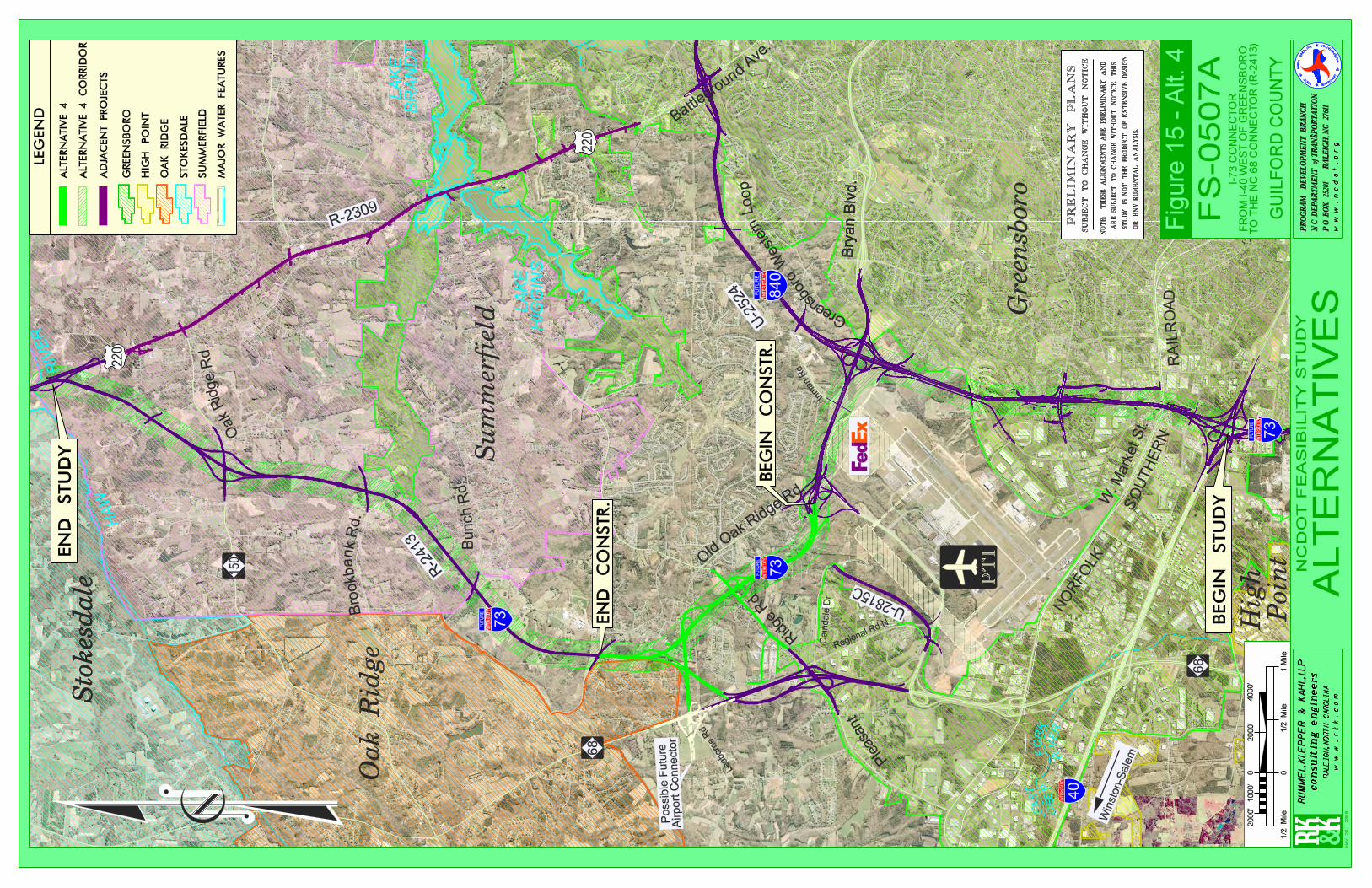
HA
W
RIV
ER
L
AK
EH
IGG
INS
L
AK
EB
RA
ND
T
EAST
FO
RK
DEE
P
RIV
ER
-Y1-
101
D
CAT-1
CAT-1
GRAU-350
GRAU-350
GRAU-350PROP. GUARDRAIL
+80.507 -L-
109.603m
+80.310 -L-
104.078m
+58.88
9 -L-
99.573
m
WCR
WCR
WCR
WCR
WCR
WCR
WCR
WCR
WCR
WCR
CAT-1GRAU-350
CAT-1GRAU-350
+37.329 -L-110.911m
WCR
WCR
EE
60
61
69
20m (TYP.)
+06.418
12.5m
R
+46
15:1
15:1
15:1
15:1
15:1
15:1
R=3
m +
64.9
92 6
m R
T.
6 m
+03.262
END FUTURE EXPWY GUTTER
FUTURE
EXPWY
GUTTER
BEG. FUT.
EXPWY
GUTTER
+90.972
38.2ftD D
D
WCR
.04
.04
.02
.02
.02
.02
.10
.10
.10
.10
.02
.02
.02
.02
.08 .08
.08
.08
.08
.08
.08
.08
.02
.02
.02
.02
.08
.08
.08
.08
.02
.02
.02
.02
.02
.08.08
.04.04
.02
.02
.02
.02
.02
.02
.02
.02
.02
.02
.02.02
.02 .02
.04 .04
.04.04
.02
.02
.04
.04
.02
.02
.02
.02
.04
.04
.02
.06.06
.06.06
.02.00
.06.06
.02
.00
.05.05
.02
.00
.06.06
.06.06
.02
.00
.02.02
.02.02
.04.04
.04.04
.04.04
.04.04
.02
.02
TDE
TDE
TDE
TDE
TDE
TDE
TDE
TDE
ALT 4
68
73
FU
TU
RE
220
15
0
220
Sto
kesdale
Su
mm
erf
ield
R-2
413
R-2309
Bry
an B
lvd.
Sto
kesdale
Oak
Rid
ge
Oak Ridge R
d.
Bro
okbank R
d.
Bunch R
d.
Battlegro
und
Ave.
Gre
en
sbo
ro
73
FU
TU
RE
PR
EL
IMIN
AR
Y P
LA
NS
SU
BJE
CT
TO
CH
AN
GE
WIT
HO
UT
NO
TIC
E
NO
TE:
T
HES
E A
LIG
NM
ENTS
AR
E PR
ELIM
INA
RY
AN
D
AR
E SU
BJE
CT
TO C
HA
NG
E W
ITH
OU
T N
OTI
CE.
T
HIS
ST
UD
Y IS
NO
T T
HE
PR
OD
UC
T O
F E
XT
EN
SIV
E D
ESI
GN
OR
EN
VIR
OM
ENTA
L A
NA
LYSI
S.
I-73 C
ON
NE
CT
OR
FR
OM
I-4
0 W
ES
T O
F G
RE
EN
SB
OR
OT
O T
HE
NC
68 C
ON
NE
CT
OR
(R
-2413)
GU
ILF
OR
D C
OU
NT
Y
2000’
02000’
4000’
1 M
ile
0
1000’
1/2
M
ile
1/2
M
ile
PR
OG
RA
M D
EV
EL
OP
ME
NT
BR
AN
CH
N.C
. D
EP
AR
TM
EN
T o
f T
RA
NS
PO
RT
AT
ION
P.O
. B
OX
25
20
1
R
AL
EIG
H,
NC
27
61
1
TR
O
EA
D
A
E
T
NF
O
TTS
NIL
O
RA
CH
PAR
M
EN
PO
RT
ATION
TN
OF
TR
AS
w w
w .
n
c d
o t
.
o
r g
RU
MM
EL
, K
LE
PP
ER
& K
AH
L, L
LP
coo
c
RA
LE
IGH
, N
OR
TH
CA
RO
LIN
A
w w
w . r
k k
. c
o m
Hig
h P
oin
t
68
Bry
an B
lvd.
Win
ston-S
ale
m
NO
RFO
LK
SO
UT
HE
RN
RAIL
RO
AD
W.
Market St.
40
84
0
FU
TU
RE
U-2
524
73
FU
TU
RE
e PT
I
Possib
le F
utu
re
Air
port
Connecto
r
Pleasa
nt
Old O
ak Ridge R
d.
Inman R
d
BE
GIN
ST
UD
Y
EN
D S
TU
DY
Regional Rd N
Cain
dale
Dr
Rid
ge R
d
LE
GE
ND
GR
EE
NS
BO
RO
HIG
H P
OIN
T
OA
K R
IDG
E
ST
OK
ES
DA
LE
SU
MM
ER
FIE
LD
AD
JAC
EN
T P
RO
JEC
TS
AL
TE
RN
AT
IVE
4
MA
JOR
WA
TE
R F
EA
TU
RE
S
AL
TE
RN
AT
IVE
4 C
OR
RID
OR
EN
D C
ON
ST
R.
FS
-0
50
7A
NC
DO
T F
EA
SIB
IL
IT
Y S
TU
DY
AL
TE
RN
AT
IVE
S
BE
GIN
CO
NS
TR
.
EF
d
ex
Gree
nsboro Western Loop
Leaborn
e R
d
U-2815C
May
20
, 2
00
8
Fig
ure
15 -
Alt
. 4

LEGEND PlantAnimalSpecial HabitatNatural CommunityState ParksState Owned ComplexesFederally Owned LandsHist. Struct.- Nat’l RegisterHist. Dist. - Nat’l RegisterAlternative 1Alternative 2Alternative 3Alternative 4
Surface Water IntakesCritical WatershedsProtected WatershedsStreamsWaterbodiesNWI WetlandsNatural AreasGreensboro
RUMMEL, KLEPPER & KAHL, LLP
c o n s u l t i n g e n g i n e e r sPROGRAM DEVELOPMENT BRANCH
N.C. DEPARTMENT OF TRANSPORTATION
P.O. BOX 25201 RALEIGH, NC 27611
w w w . r k k . c o m
RALEIGH, NORTH CAROLINA
w w w . n c d o t . o r g
ALT. 3
Haw
River
ALT. 4ALT. 1
ALT. 2
Lake Brandt
LakeHiggins
E Fork Deep River
Greensboro
I-73 Connec to rFrom I -40 to t he US 220-NC 68 Connec tor (R-2413)
Greensboro , Gui l fo rd Coun ty
FIGURE 16 - ENVIRONMENTAL FEATURES MAPNCDOT FEASI BILITY STUDY F S-0507A


