F1- NAVIGATION 1. Generation or production of cyclones. A. frontal depression B. frontogenesis C. frontolysis D. cyclogenesis 2. Water vapor over the plane ice surface is less than that plane water surface because____________. A. plane ice surface is cooler than plane water surface B. water vapor is directly proportional with the temperature of the air C. water vapor is proportional with the temperature of the air D. the molecules are more tightly bound in the solid state 3. During poor visibility, a watch keeping officer is given fullest responsibility to utilize all available resources on the bridge, with respect to additional look-outs, does it mean the extra look-out should perform _________. A. stand on the bridge wing with binoculars, come rain or snow B. report to Master any misbehavior on the bridge C. radar monitoring D. officer's personal and official messenger 4. The type of clouds which is formed by a very extensive of two masses of air from middle latitudes and from higher and colder latitudes, associated with front. A. Cumulus-Nimbus B. Frontal Cloud C. Orographic Cloud D. Cumulus 5. Buy's Ballot Law which states "If you stand with your back to the wind in the northern hemisphere, higher pressure will be on the right hand and lower pressure on the left, the reverse is true in the southern hemisphere". This law is evolved by a __________. A. German B. Dutchman C. French D. English 6. The most convenient method of maintaining record of ship's magnetic compass deviation is the annual adjustment of this particular reference, otherwise known as ___________. A. deviation daily observation record B. deviation card C. magnetic chart D. compensation card 1
Transcript
F1- NAVIGATION
1. Generation or production of cyclones. A. frontal depression B. frontogenesis C. frontolysis D. cyclogenesis2. Water vapor over the plane ice surface is less than that plane water surface because____________. A. plane ice surface is cooler than plane water surface B. water vapor is directly proportional with the temperature of the air C. water vapor is proportional with the temperature of the air D. the molecules are more tightly bound in the solid state3. During poor visibility, a watch keeping officer is given fullest responsibility to utilize all available resources on the bridge, with respect to additional look-outs, does it mean the extra look-out should perform _________. A. stand on the bridge wing with binoculars, come rain or snow B. report to Master any misbehavior on the bridge C. radar monitoring D. officer's personal and official messenger4. The type of clouds which is formed by a very extensive of two masses of air from middle latitudes and from higher and colder latitudes, associated with front.
A. Cumulus-Nimbus B. Frontal Cloud C. Orographic Cloud D. Cumulus5. Buy's Ballot Law which states "If you stand with your back to the wind in the northern hemisphere, higher pressure will be on the right hand and lower pressure on the left, the reverse is true in the southern hemisphere". This law is evolved by a __________. A. German B. Dutchman C. French D. English6. The most convenient method of maintaining record of ship's magnetic compass deviation is the annual adjustment of this particular reference, otherwise known as ___________. A. deviation daily observation record B. deviation card C. magnetic chart D. compensation card7. This is a very valuable publications in determining physical characteristics of the weather and other meteorological knowledge, as published by the Hydrographic Department of the Ministry of Defense of U.K. A. Almanac B. The Mariner’s Handbook C. Sight Reduction Tables D. Pilot Chart8. Hard iron is very hard to magnetized, but once magnetized, it retains its poles more or less permanently. Magnetism in hard iron is termed. A. permanent magnetism B. induced magnetism C. increased magnetism D. reduced magnetism9. This physical element has most considerable effect in the weather. A. none of these B. oxygen C. nitrogen D. water vapor
1
10. A unit measuring the strength of a magnetic field is called __________. A. gauss B. degauss C. sauger D. srauss11. To indicate a compass adjustment in progress, which international code signal is hoisted? A. Oscar Quebec B. Mike Sierra C. Oscar Mike D. Charlie Alpha12. The following are positive signs of open water in ice concentration EXCEPT: A. water sky indicates the direction of leads or patches of open water B. the sound of surge in the ice indicates large expanse of open water C. refractions producing luminous and yellow haze on the horizon D. dark spots in fog visible at short distance relative to the reflections of the clouds13. A radio navigation system which operates in a very low frequency is called: A. Loran C B. Loran A C. RDF D. Omega14. If you want to know the coordinates of a certain port, the best publication to provide fastest reference is the __________. A. coast pilot B. sailing directions C. world port index D. notice to mariners15. The pressure of the atmosphere fall off with increasing height above the Earth's surface, because _____________. A. density decreases with temperature and temperature decreases with height B. earth's gravitational force sustains air by escaping C. density increases with temperature and temperature increases with height D. since the pressure of the atmosphere is due to the weight of the column of air overhead as one ascends, leaving some of the column of air below.16. The official document where all pertinent entries are recorded every hour and whenever an even or unusual incident occurs is _________________. A. Ship's Official Log Book B. ISM Checklist C. Master's Night Order D. None of these17. The term used to denote a body being revolved to by its satellites. A. secondary B. tertiary C. territoriality D. primary18. What is the angle at the observer between the magnetic north measured clockwise, to the direction of the object being measured? A. None of these B. True course of bearing C. Magnetic course or bearing D. Compass course or bearing19. When you are steering on a pair of range lights and find the upper light is above the lower light you should__________. A. come left B. come right C. continue on the present course D. wait until the lights are no longer in a vertical line
2
20. Most modern Loran-C receivers, when not tracking properly, have a (n) _________. A. bell alarm to warn the user B. lighted alarm signals to warn the user C. alternative signal keying system D. view finder for each station21. You have replaced the chart paper in the course recorder. What is Not required to ensure that a correct trace is recorded? A. Test the electrical gain to the thermograph pens B. Set the zone pen on the correct quadrant C. Line the course pen up on the exact heading of the ship D. Adjust the chart paper to indicate the correct time22. Which buoy is Not numbered? A. Green can buoy B. Preferred channel buoy C. Red lighted buoy D. Green gong buoy23. If Loran-C signals become unsynchronized, the receiver operator is warned because; A. signals begin to blink B. signals begin to shift C. stations discontinue transmission D. stations transmit grass24. When the gyro pilot is used for steering, what control is adjusted to compensate for varying sea conditions? A. Rudder control B. Sea control C. Lost motion adjustment D. Weather adjustment25. When using a buoy as aid to navigation, which of the following should be considered? A. The buoy should be considered to always be in the charted location B. If the light is flashing, the buoy should be considered to be in the charted location C. The buoy may not be in the charted position D. The buoy should be considered to be in the charted position if it has been flashing26. When taking an amplitude, the Sun's center should be observed on the visible horizon when A. in high latitudes B. the Sun is near or at a solstice C. the declination is of a different name from the latitude D. the Sun's declination is at or near 0º27. A strong, often violent, northerly wind occurring on the Pacific coast of Mexico particularly during the colder months is a ____________. A. papagayo B. fall wind C. foehn D. williwaw28. A buoy with composite group flashing light indicates a (n) __________. A. anchorage area B. fish net area C. bifurcation D. dredging area29. The speed of the sound through ocean water is nearly always _____________. A. faster than the speed of calibration for the fathometer B. the same speed as the speed of calibration for the fathometer C. slower than the speed of calibration for the fathometer D. faster than the speed of calibration for the fathometer, unless the water is very warm
3
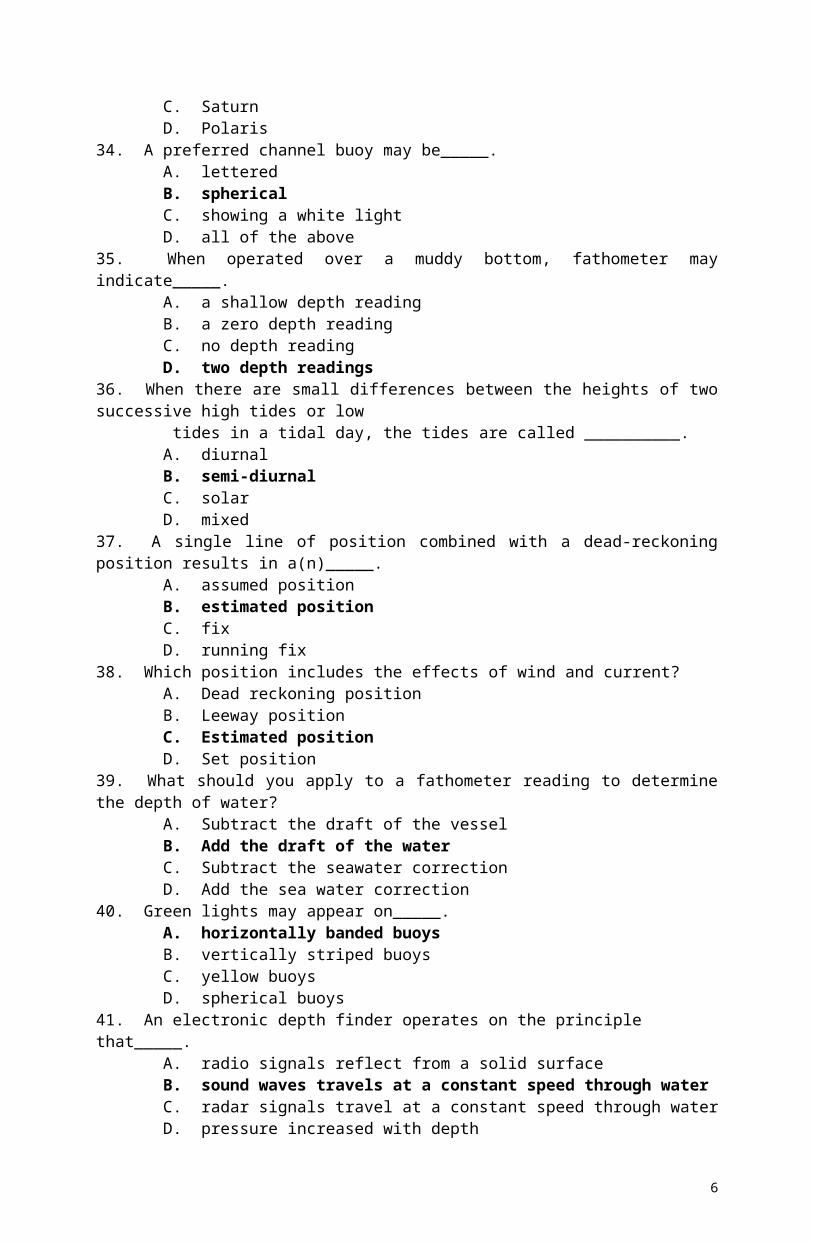
30. Red lights may appear on _____________. A. horizontally banded buoys B. vertically stripped buoys C. yellow buoys D. spherical buoys31. Mean lower low water is the reference plane used for ___________. A. all vertical measurements B. heights above water for lights, mountains, etc. C. sounding on the U.S. east and west coasts D. water depths on the U.S. east coast only32. The LMT of LAN is 1210. Your longitude is 70º 30' E. Which time would you use to enter the Nautical Almanac to determine the declination of the Sun at LAN? A. 1842 B. 1652 C. 0728 D. 065233. The parallax angle will vary the most with the time of year _____. A. Venus B. Jupiter C. Saturn D. Polaris34. A preferred channel buoy may be_____. A. lettered B. spherical C. showing a white light D. all of the above35. When operated over a muddy bottom, fathometer may indicate_____. A. a shallow depth reading B. a zero depth reading C. no depth reading D. two depth readings36. When there are small differences between the heights of two successive high tides or low tides in a tidal day, the tides are called __________. A. diurnal B. semi-diurnal C. solar D. mixed37. A single line of position combined with a dead-reckoning position results in a(n)_____. A. assumed position B. estimated position C. fix D. running fix38. Which position includes the effects of wind and current? A. Dead reckoning position B. Leeway position C. Estimated position D. Set position39. What should you apply to a fathometer reading to determine the depth of water? A. Subtract the draft of the vessel B. Add the draft of the water C. Subtract the seawater correction D. Add the sea water correction40. Green lights may appear on_____. A. horizontally banded buoys B. vertically striped buoys C. yellow buoys D. spherical buoys
4
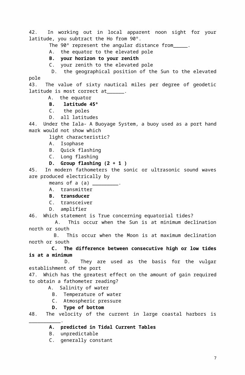
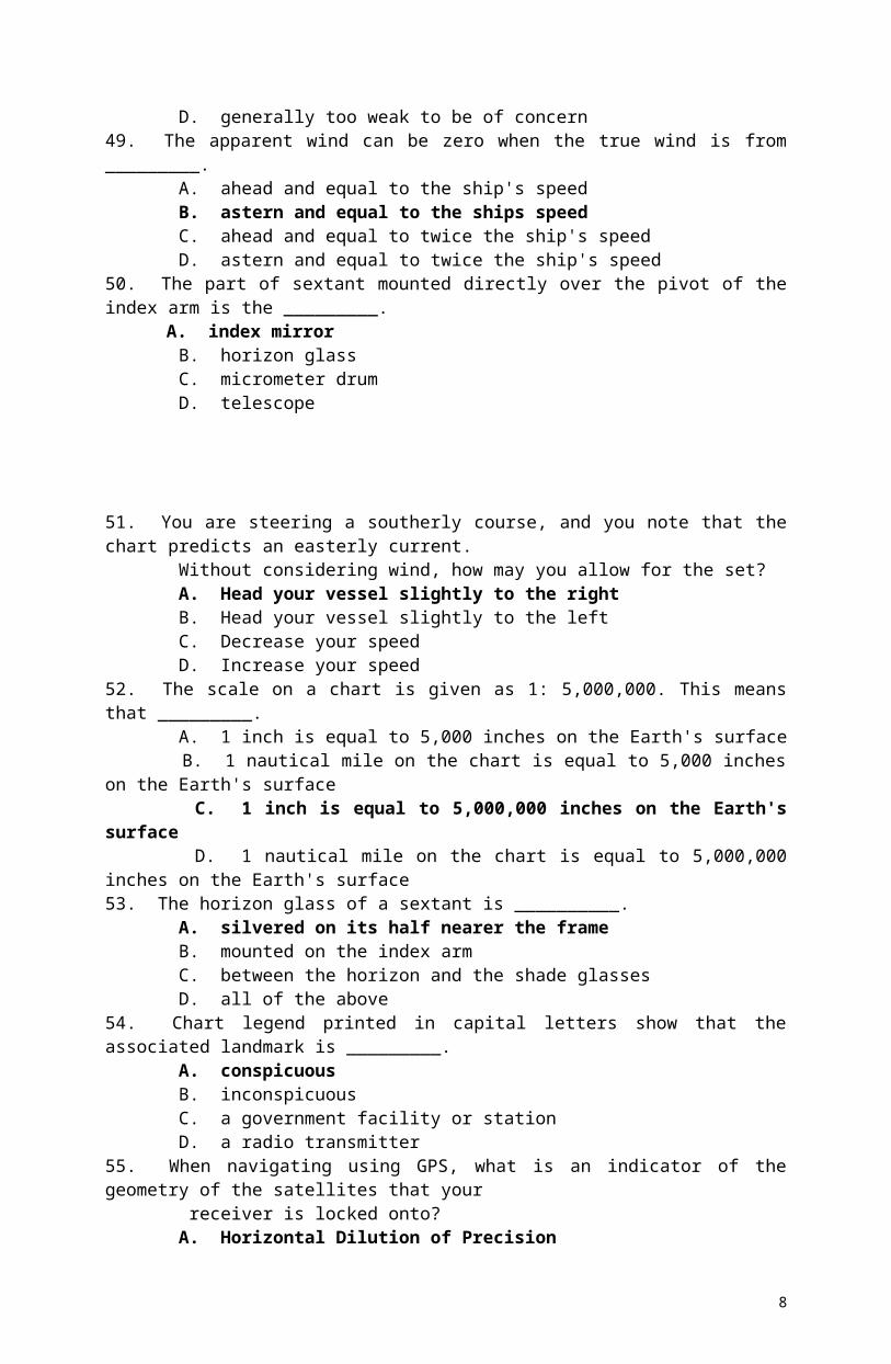
41. An electronic depth finder operates on the principle that_____. A. radio signals reflect from a solid surface B. sound waves travels at a constant speed through water C. radar signals travel at a constant speed through water D. pressure increased with depth42. In working out in local apparent noon sight for your latitude, you subtract the Ho from 90º. The 90º represent the angular distance from_____. A. the equator to the elevated pole B. your horizon to your zenith C. your zenith to the elevated pole D. the geographical position of the Sun to the elevated pole43. The value of sixty nautical miles per degree of geodetic latitude is most correct at______. A. the equator B. latitude 45º C. the poles D. all latitudes44. Under the Iala- A Buoyage System, a buoy used as a port hand mark would not show which light characteristic? A. Isophase B. Quick flashing C. Long flashing D. Group flashing (2 + 1 )45. In modern fathometers the sonic or ultrasonic sound waves are produced electrically by means of a (a) _________. A. transmitter B. transducer C. transceiver D. amplifier 46. Which statement is True concerning equatorial tides? A. This occur when the Sun is at minimum declination north or south B. This occur when the Moon is at maximum declination north or south C. The difference between consecutive high or low tides is at a minimum D. They are used as the basis for the vulgar establishment of the port47. Which has the greatest effect on the amount of gain required to obtain a fathometer reading? A. Salinity of water B. Temperature of water C. Atmospheric pressure D. Type of bottom48. The velocity of the current in large coastal harbors is ___________. A. predicted in Tidal Current Tables B. unpredictable C. generally constant D. generally too weak to be of concern49. The apparent wind can be zero when the true wind is from _________. A. ahead and equal to the ship's speed B. astern and equal to the ships speed C. ahead and equal to twice the ship's speed D. astern and equal to twice the ship's speed50. The part of sextant mounted directly over the pivot of the index arm is the _________. A. index mirror B. horizon glass C. micrometer drum D. telescope
5
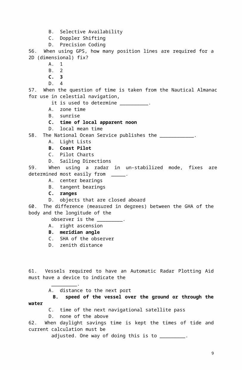
51. You are steering a southerly course, and you note that the chart predicts an easterly current. Without considering wind, how may you allow for the set? A. Head your vessel slightly to the right B. Head your vessel slightly to the left C. Decrease your speed D. Increase your speed52. The scale on a chart is given as 1: 5,000,000. This means that _________. A. 1 inch is equal to 5,000 inches on the Earth's surface B. 1 nautical mile on the chart is equal to 5,000 inches on the Earth's surface C. 1 inch is equal to 5,000,000 inches on the Earth's surface D. 1 nautical mile on the chart is equal to 5,000,000 inches on the Earth's surface53. The horizon glass of a sextant is __________. A. silvered on its half nearer the frame B. mounted on the index arm C. between the horizon and the shade glasses D. all of the above54. Chart legend printed in capital letters show that the associated landmark is _________. A. conspicuous B. inconspicuous C. a government facility or station D. a radio transmitter55. When navigating using GPS, what is an indicator of the geometry of the satellites that your receiver is locked onto? A. Horizontal Dilution of Precision B. Selective Availability C. Doppler Shifting D. Precision Coding56. When using GPS, how many position lines are required for a 2D (dimensional) fix? A. 1 B. 2 C. 3 D. 457. When the question of time is taken from the Nautical Almanac for use in celestial navigation, it is used to determine __________. A. zone time B. sunrise C. time of local apparent noon D. local mean time58. The National Ocean Service publishes the ____________. A. Light Lists B. Coast Pilot C. Pilot Charts D. Sailing Directions59. When using a radar in un-stabilized mode, fixes are determined most easily from _____. A. center bearings B. tangent bearings C. ranges D. objects that are closed aboard60. The difference (measured in degrees) between the GHA of the body and the longitude of the observer is the _________. A. right ascension B. meridian angle C. SHA of the observer D. zenith distance
6
61. Vessels required to have an Automatic Radar Plotting Aid must have a device to indicate the _________. A. distance to the next port B. speed of the vessel over the ground or through the water C. time of the next navigational satellite pass D. none of the above62. When daylight savings time is kept the times of tide and current calculation must be adjusted. One way of doing this is to _________. A. subtract one hour from the times listed under the reference stations B. add one hour from the times listed under the reference stations C. apply no corrections, as the times in the reference stations are adjusted for daylight savings time D. add 15 to the starboard meridian when calculating the time difference63. When making landfall at night, the light from the powerful lighthouse may sometimes be seen before the lantern breaks the horizon. This light is called ___________. A. diffusion B. backscatter C. loom D. elevation64. Prior to reading an aneroid barometer, you should tap the face lightly with your finger to___. A. expose any loose connections B. demagnetized the metal elements C. bring pointer to its true position D. contract and expand the glass face65. What is an advantage of the magnetic compass aboard vessel? A. Compass error is negligible at or near the earth's magnetic pole B. It does not have to be checked as often C. It is reliable due to its essential simplicity D. All points on the compass rose are readily visible66. You are using radar in which your own ship is shown at the center, and the heading flash always points at 0. If bearings are measured in relation to the flash, what type of bearings are produced? A. Relative B. True C. Compass D. Magnetic67. What is True concerning an anemometer on a moving vessel? A. It measures true wind speed B. It measures true wind speed and true wind direction C. It measures apparent wind speed D. It measures apparent wind speed and true wind direction68. The tropical year differs from which year by 20 minutes? A. Astronomical year B. Natural year C. Equinoctial year D. Sidereal year69. The arc of great circle, which passes through the body and celestial poles is part of the _______. A. hour circle B. diurnal circle C. observer's meridian D. altitude circle
7
70. The chart of a beach area shows a very steep slope to the underwater beach bottom. Which breakers can be expected when trying to land a boat on this beach? A. Surging B. Converging C. Spilling D. Plunging71. Low pressure disturbances, which travel along the inter-tropical convergence zone are called _______. A. permanent waves B. tidal waves C. tropical waves D. tropical storms72. Barometers are calibrated at a standard temperature of _________. A. 0 F B. 32 F C. 60º F D. 70 F73. In which voyage, between two points, is the rhumbline distance Not approximately the same as the great circle distance? A. The two points are in low latitudes in the same hemisphere B. The two points are in high latitudes in the same hemisphere C. The two points is near the equator, but in different hemisphere D. One point is near the equator, one point is in a high latitude and both are near the 180th meridian74. Which statement is True concerning Mercator projection? A. Degrees of longitude decrease in length as latitude increases B. The length of the meridian is increased to provide for equal expansions in all directions C. The mileage between the meridians is increased as the latitude increases D. All of the above75. What kind of weather would you expect to accompany the passage of a tropical wave? A. Heavy rain and cloudiness B. Good weather C. A tropical storm D. Dense fog76. You have another ship overtaking you close aboard to starboard. You have 3 radar target bearings 090 relative at ranges of 0.5 miles. In this case, the unwanted echoes are called ____. A. multiple echoes B. spoking C. indirect echoes D. side-lobe echoes77. When using the radar for navigating __________. A. the best fix is obtained by using a tangent bearing and a range B. and using two radar range for a fix, the object of the ranges should be closed to reciprocal bearings C. and using ranges, the most rapidly changing range should be measured last D. and crossing a radar range of one object with the visual bearings of a second object, the two objects should be 80 to 110 apart78. What is the length of a nautical mile? A. 1,850 meters B. 5,280 meters C. 1,760 yards D. 6,076 feet
8
79. A swift current occurring in a narrow passage connecting two large bodies of water, which produced by the continuously changing difference in height of tide at the two ends of the passage, is called _________. A. hydraulic current B. rectilinear current C. rotary current D. harmonic current80. Your ARPA had two guard zones. What is the purpose of the inner guard zone? A. Alert the watch officer that a vessel is approaching the preset CPA limit B. Warn of small targets that are initially detected closer than the outer guard zone C. Guard against targets loss during critical maneuvering situations D. Sound an alarm for targets first detected within the zone81. What is True of the history display of a target's past position on an ARPA? A. It provides a graphic display to emphasize which vessel is on collision course B. In the true presentation, it provides a quick visual check to determine if a vessel has changed course C. The display is one of the primary inputs and must be in use when using the trial maneuver capability D. It provides a graphic display of a target vessel's relative course, speed and CPA82. Most GPS receiver use the doppler shift of the carrier phase to compute the________. A. latitude B. longitude C. speed D. time83. What is a common unit of measure for atmospheric pressure? A. Centimeters B. Inches C. Degrees D. Feet84. As a vessel change course to starboard, the compass card in a magnetic compass_________. A. first turn starboard then counterclockwise to port B. also turn to starboard C. remains aligned with compass north D. turns counterclockwise to port85. Chart correction information is Not disseminated through the_____________. A. Summary of Corrections B. Local Notice to Mariners C. Daily Memorandum D. Chart Correction Card86. Diurnal aberration is due to _____________. A. motion of the Earth in its orbit B. rotation of the Earth on its axis C. the body's orbital motion during the time required for its light to reach the Earth D. a false horizon87. The greater pressure difference between a high and a low pressure center, the __________. A. dryer the air mass will be B. cooler temperature will be C. greater the force of the wind will be D. warmer the temperature will be88. At the magnetic equator there is no induced magnetism in the vertical soft iron because______. A. the lines of force cross the equator on a 0º- 180º alignment B. the quadrantal error is 0º C. there is no vertical component of the Earth's magnetic field D. the inter-cardinal headings have less than 1º error
9
89. When taking stars, those bodies to the east and west will ____________. A. change altitude rapidly B. change altitude slowly C. remain in an almost fixed position D. appear to be moving in the plane of the horizon 90. A navigator fixing a vessel's position by a radar ______________. A. must use information from targets forward of the beam B. should never use radar bearings C. should only use radar bearings when the range exceeds the distance to the horizon D. can use radar information from one object to fix the position91. When a buoy is in position only during a certain period of the year, where may the dates when the buoy is in position be found? A. Light List B. Notice to Mariners C. On the chart D. Coast Pilot92. The National Imagery and Mapping Agency's (NIMA) List of Lights for coasts other than the United States and its possessions does Not provide information on __________. A. lighted buoys in harbors B. storm signal stations C. radio direction finder stations at or near lights D. radio beacons located at or near lights93. The quadrantal spheres are used ____________. A. remove deviation on the inter cardinal headings B. remove deviation on the cardinal compass headings C. remove heeling error D. compensate for induced magnetism in vertical soft iron94. An aneroid barometer reading should be corrected for differences in _____________. A. elevation B. temperature C. wind speed D. latitude 95. At what angle to the isobars do surface wind blows over the open sea? A. About 90º B. About 50º C. About 25º D. About 15º 96. Isobaric configuration with low pressure refers to as ___________. A. trough B. wedge C. saddle D. col97. Precession of the earth's axis is caused by ____________. A. movement of celestial equator as celestial poles move likewise B. gravitational forces of the Sun and the moon acting on the earth's equatorial bulge C. movement of vernal equinox westerly due to gravitational attraction D. westward motion of the equinoxes along the ecliptic98. If the observer is at Lat 50º N, declination of the sun is 15º S, which of the following is observed? A. daylight and darkness are equal B. darkness is longer than daylight C. daylight is longer than darkness D. darkness is shorter than daylight
10
99. When certain ferromagnetic materials are so susceptible to a magnetizing field that they draw the flux lines into themselves, resulting in a greatly increased concentration of lines within the materials, is referred to as __________. A. polarization B. susceptibility C. magnetic induction D. permeability100. A concentration of sea ice covering hundreds of square miles, which is found on the same region, is referred to as ______________. A. ice remains B. ice deposit C. ice leftover D. ice mass101. When the radar waves are trapped in the atmosphere, which of the following occurs? A. Loss of energy to the radio waves B. Radar energy remain unchanged C. Increased in radar range D. Radar energy remain unchanged 102. When air is compressed its temperature increases conversely, when it is allowed to expand, its temperature decreases. This changes is due to__________. A. saturation B. adiabatic changes C. evaporation D. condensation103. This is one factor affecting gain and low speed of a ship. Heavier ships are slower to gain and loose speed than smaller ships. This variable is referred to as ________. A. size of ships B. inertia C. shape of hull D. none of these104. Following are unwanted echoes Except ; A. normal radar echoes B second trace echoes C. weather echoes D. none of these105. The extension of the earth's equator to the celestial sphere. A. declination B. equinoctial C. diurnal circle D. prime vertical106. The path of a ship compass platform as she turn through 360º at a certain speed and with a certain rudder angle is called; A. pivoting point B. turning circle C. thrust D. drift angle107. Which among these unit is Not a part of a SATNAV? A. Transmitter B. Antenna C. Video display D. Data processor108. The ability of a radar to distinguish targets relative to range, is called ___________. A. range elongation B. range segregation C. range propagation D. range resolution
11
109. If the LMT is ahead of the LAT the equation of time is ___________. A. negative B. same as LAT C. same as LMT D. positive110. Ocean swells originating from a typhoon can move ahead of it at speeds near _______. A. 10 knots B. 20 knots C. 30 knots D. 50 knots111. When the time of the high water is known, the approximate time for low water can be determined by adding or subtracting one forth of a lunar day which is equivalent to: A. 6h-13m B. 6h-33m C. 6h-45m D. 6h-05m112. The velocity of rotary tidal current will decrease when the moon is: A. full B. at apogee C. at perigee D. on the equator113. Slack tidal current usually occurs how many times daily? A. Two B. One C. Four D. Three114. Why is the height of the tide in the Tide Table essential in determining the true depth of water at any time than shown in the chart? A. The depth of the water at any time is obtained by adding the height of the tide to the charted depth B. The depth of the water at any time is obtained by subtracting the height of the tide if it is negative C. The height of the tide may be checked readily by taking soundings to be sure of the keel clearance from the bottom D. If the height of the tide is equal to the charted depth is an alarm that the ship may touch Bottom115. The highest low water datum in considerable use is: A. Mean Lower Low Water (MLLW) B. Mean Low Water (MLW) C. Mean Lower High Water (MLHW) D. Lowest Low Water (LLW)116. The admiralty tide tables are published in UK in the volumes covering all bodies of waters worldwide. Which of the following area is not covered by these volumes? A. The Artic and Antarctic Oceans B. The Atlantic and Indian Oceans C. European Water D. The Pacific and adjacent seas117. What may occur when strong current set over irregular bottom or meets opposing currents? A. Tsunami B. Wave C. Ebb current D. Tide rips
12
118. In the East Coast of the Philippines Archipelago the effect of Tropic Tides is less marked. There are usually ___, high water and ___low water each lunar day. A. One, one B. Two, two C. One, two D. Two, one119. The times and heights of high and low waters as predicted in the admiralty tide table are for: A. standard ports B. primary ports C. secondary ports D. major ports120. The sky is overcast and there is a moderate southerly wind at night. This means______________. A. temperature will generally rise B. temperature will generally fall C. winds will generally rise D. winds will generally fall121. Which of the following statements is True with respect to ship handling procedures in ice? A. Anchoring in the presence of ice is not recommended except in an emergency B. Towing a vessel through an ice field is not recommended except in an emergency C. The "free and proceed" system of escorting a beset cuts down on the number of freeing operations D. When anchoring in ice it is advisable to increase the scope of the chain 122. Which of the following is ice of land origin? A. Shuga B. Floe C. Spicule D. Bergy bit123. Which of the following types of ice a hazard to navigation? A. Ice rind B. Pancake ice C. Frazil ice D. Growlers124. Multi-layer ice is the hardest sea ice and should be avoided if possible. What is the surface color of this type of ice? A. Greenish B. Bluish C. Grey D. Grey-white125. Which of the following is Not an indication that pack ice may be nearby? A. The presence of icebergs B. Ice blink C. Absence of wave motion D. Sighting a walrus in the Arctic126. The proximity of pack ice may be indicated by ___________. A. changes in sea water salinity B. glare on clouds on the horizon C. changes in air temperature D. icebergs127. Which characteristics is common to advection fog? A. It commonly occurs on coastal waters during cold seasons B. It moves in a "bank" or dense cloud C. It is caused by warmer air moving to a cooler location D. All of these characteristics are common to advection fog
13
128. Ascending and descending air masses with different temperatures is part of an important that transmitting processes in our atmosphere called: A. conduction B. radiation C. convection D. barometric inversion129. Air circulation is caused or affected by: A. The rotation of the earth on its axis B. Convection currents caused by differences in radiant heating between equator and polar regions C. Mountain ranges D. All of the above130. This is an area in which either navigation is particularly hazardous or it is exceptionally important to avoid casualties and which should be avoided by all ships, or certain classes of ships A. precautionary area B. area to avoided C. roundabout D. traffic lane131. You are running parallel to the coast and take a running fix using bearing of the same object. You are making more speed than used for the running fix. In relation to the position indicated by the fix, you will be: A. closer to the coast B. farther from the coast C. on the track line ahead of the fix D. on the track line behind the fix132. You are running parallel to the coast and estimate that the current is against you. In plotting a running fix using bearing from the same object on the coast, the greatest safety margin from inshore dangers will result if what speed is used to determine the fix? A. Minimum speed estimate B. Maximum speed estimate C. Average speed estimate D. A running fix should not be used under this condition133. When you turn on the fast time constant (differentiator) control of a radar it will ____. A. Enhance weak target echoes and brighten them on the PPI B. Reduce clutter over the entire PPI by shortening the echoes C. Only suppress weak targets to a limited distance from the ship (sea clutter) D. Reduce the beam width to provide a map-like presentation for navigation134. The radar control that shortens all echoes on the display and reduces clutter caused by rain or snow is the? A. Sensitivity time control B. Receiver gain control C. Brilliance control D. Fast time constant (differentiator)135. The radar control that reduces weak echoes out to a limited distance from the ship is the? A. Sensitivity time control (sea clutter control) B. Receiver gain control C. Brilliance control D. Fast time constant (differentiator) 136. If there is any doubt as to the proper operation of a radar, which of the following is true? A. Only a radar expert can determine if the radar is operating B. All radars have indicator lights and alarms to signal improper operation C. A radar range compared to the actual range of a known object can be used to check the operation of the radar D. The radar resolution detector must be energized to check the radar
14
137. What is the approximate wave length of an X band radar operating on a frequency of approximately 9500 MHz? A. 3 cm B. 10 cm C. 30 cm D. 100 cm138. The 3 cm radar as compared to a 10 cm radar with similar specification will_____. A. give better range performance in rain, hail, etc. B. display small targets in a mass of dense sea clutter at a greater range C. have less sea return in choppy rough seas D. display a more map like presentation for inshore navigation139. The 10 cm radar as compared to a 3 cm radar similar specifications will ____. A. be more suitable for river and harbor navigation B. provide a better range performance on low lying targets during good weather and calm seas C. have a wider horizontal beam width D. have more sea return during rough sea conditions140. Your radar indicates a target; however there is no visible object at the point indicated. A large mountain, approximately 50 miles away on the same bearing as the target, is breaking the horizon. You should suspect the radar target is caused by ________. A. a submerge submarine B. ducting C. sub-refraction D. ionospheric skip waves141. What condition indicates that your radar needs maintenance? A. Serrated range rings B. Indirect echoes C. Multiple echoes D. Blind sector142. You are underway at 5 knots and see on your radar a contact 10 miles directly astern of you, 12 minutes later, the contact is 8 miles directly astern of you. What is the estimated speed of the contact? A. Dead in the water B. 1 knot C. 10 knots D. 15 knots143. You are underway at 10 knots. At 1800 you note a radar contact dead ahead at a range of 10 miles. At 1812 the contact is dead ahead at a range of 8 miles. The estimated speed of the contact is ______. A. Dead in the water B. 5 knots C. 10 knots D. 15 knots144. The closet point of approach (CPA) of a contact on a relative motion radar may be determined ______. A. immediately when the contact is noted on radar B. only if the radar scope is watched constantly C. after the contact has been marked at least twice D. by an occasional glance at the radar145. Wind velocity varies_____________. A. directly with the temperature of the air mass B. directly with the pressure gradient C. inversely with the barometric pressure D. inversely with the absolute humidity
15
146. A local wind known as "Williwaws" is associated with what particular place in the world? A. Arabian Gulf B. West Mediterranean C. Aegean Sea D. Straits of Magellan147. A local wind known as "Vendevale" is associated with what particular place in the world? A. West Mediterranean B. Arabian Gulf C. Gulf of Mexico D. Panama148. A local wind known as "Simood" is associated with what particular place in the world? A. Arabia B. Gulf of Aden C. Egypt D. Gulf of Aden149. A local wind known as "Etesian" is associated with what particular place in the world? A. Aegean Sea B. Arabian Gulf C. Gulf of Aden D. South America150. This is a hot wind that blows off the coast of Australia. A. Brickfielder B. Elephanta C. Foehn D. Harmattan151. Which of the following meteorological sources of information provides picture of the existing condition and shows the position of isobars and other details such as fronts and troughs etc? A. Surface Prognostic Chart B. Surface Synoptic Analysis Chart C. Change of Pressure Chart D. Upper Air Chart152. Which of the following meteorological sources of information provides a projection of synoptic condition ahead in time and cover periods of 12, 36 and 72 hours? A. Upper Air Chart B. Surface Synoptic Analysis Chart C. Surface Prognostic Chart D. Change of Pressure Charts153. Which of the following meteorological sources of information show isobaric lines? This chart also helps to forecast the movement of depressions. A. Change of Pressure Chart B. Airwave Chart C. Surface Prognostic Chart D. Upper Air Charts154. Which of the following meteorological source of information are used by shore based meteorologists to obtain information on the movement of depressions and other expected weather conditions? A. Surface Prognostic Charts B. Nephanalysis Charts C. Hindcast Charts D. Upper air charts
16
155. Which of the following meteorological sources of information are used by shore based meteorological to obtain information on thickness of clouds, and constant pressure analysis and other prognostic chart? A. Upper Air Charts B. Nephanalysis Charts C. Hindcast Charts D. Change of Pressure Charts156. These are satellite information chart providing information on clouds pattern and cloud thickness.They assist in the identification of meteorological features like tropical revolving storms. A. Hindcast Charts B. Nephanalysis Charts C. Upper Air Charts D. Surface Prognostic Charts157. These are meteorological charts which compare weather and progress along the route as advised by the British Meteorological Office with the weather and progress that would have been experienced and/or achieved along and appropriate alternative route. A. Hindcast Chart B. Nephanalysis Charts C. Upper Air Charts D. Air Wave Charts158. Which of the following radio facsimile transmission show weather pattern based on synoptic surface observations? A. Extended Surface Prognosis B. Surface Weather Prognosis C. Surface Weather Analysis D. Extended Weather Analysis 159. Which of the following radio facsimile transmission indicate future weather patterns for either a 24-hour or 36-hour outlook for specific regions? A. Surface Weather Prognosis B. Surface Weather Analysis C. Extended Surface Prognosis D. Wave Patterns160. Which of the following radio facsimile transmission indicate forecast position of fronts and pressure system at the surface for a period of 2 to 5 days? A. Surface Weather Analysis B. Extended Surface Prognosis C. Surface Weather Prognosis D. Weather Prognosis Charts161. These are radio facsimile transmissions that show characteristic of "sea waves". They are based on synoptic wave observation made shortly before transmission on calculations derived from wind and wave patterns. Which of these two facsimile satisfy this description? I. Wave Analysis II. Wave Prognosis A. I is correct B. II is correct C. I & II are both correct D. I & II are incorrect162. Ship owners often provides guidelines to Masters as an aid in establishing a most suitable route and in line with company policy. Which of the following preferences will ship owners consider in giving the master his choice of suitable route? A. Speed of passage B. Safety of vessel C. Economy D. All of these considerations are preferable
17
163. Ship owners often provides guidelines to masters as an aid in establishing a most suitable route and in line with company policy. Which of the following preferences will be ship owners considering in giving the master his choice of suitable route? A. Comfort B. Dependability C. Design of vessels D. All of these considerations are preferable164. In addition to climatic considerations, masters will need to consider a number of factors when selecting an ocean passage route. Which of the following items will be included in the master's considerations? A. Type of vessel, draft and state of loading B. Time of year and the expected weather sea condition C. The possibility of encountering gale force winds causing subsequent delays or damage to the vessels D. All of these items can be considered165. In addition to climatic considerations, masters will need to consider a number of factors when selecting an ocean passage route. Which of the following items will be included in the master's considerations? A. Recommendation obtained from reference to the "Ocean Passage of the World" B. Whether the vessels is ice strengthened and suitably equipped from ice regions C. Ability to carry out optional tasks such as hatch cleaning D. All of these items can be considered166. Which of the following options should the master consider as foremost when dealing with the commercial influences on the choice of route? A. Owners or charterer’s direct instructions B. The distance of alternative routes considered against fuel costs and time C. Cost of employing "shore based routing services" D. Maintenance of the safety of the ship and the crew167. Which of the following items is Not an advantage of "shore-based routing"? A. Savings in fuel and time B. Reductions in ship and cargo damages, with reduced wear on main engine propulsion systems C. Increase insurance premium D. Maintenance at sea is usually possible in better weather168. The distance at which the heliocentric parallax in one second (1") is termed___________. A. parsec B. magnitude C. astronomical unit D. light year169. One parsec is equal to ________. A. 3.26 light year B. 0.1 light year C. 1.0 light year D. 2.2 astronomical unit170. The term which refers to the speed at which the molecules making the atmosphere should attain to overcome the force of gravity_______. A. molecular speed B. velocity of escape C. orbit speed D. orbital velocity171. If the temperature of the mass of air increases in which the moisture content remains constant. A. none of these B. the relative humidity of that air will decrease C. the relative humidity remains constant D. the relative humidity of that air will increase
18
172. The special term which refers to the full moon nearest the autumnal equinox__________. A. harvest moon B. hunter's moon C. winters moon D. autumnal moon173. The term "Hunter's moon" refers to a full moon which occurs _____________. A. one month after the autumnal equinox B. during the spring equinox C. when the moon is nearest the autumnal equinox D. when the moon is nearest the vernal equinox174. At a certain day at a certain time in a tropical region the moon rises at GMT 0807H. What is the approximate GMT of the next moon rise?
A. 0717H B. 0857H C. 0959H D. 0615H175. The moon is said to be "waxing" during the period from________. A. new moon to full moon B. full moon to new moon C. last quarter to first quarter D. first quarter to last quarter176. The moon is said to be "waning" during the period from________. A. full moon to new moon B. new moon to full moon C. last quarter to first quarter D. first quarter to last quarter177. The points of intersection of the moon's orbit and the orbit of the earth is known as___________. A. nodes B. ecliptic C. saros D. corona178. For a lunar eclipse to occur, which of the following conditions must be satisfied? A. The moon must be at first quarter B. The moon must be at the one of the nodes C. The moon must be at last quarter D. The moon must be at quadrature179. This is an essential area of planning that involves an operation carried out by the navigation officers which gathers together all relevant information that benefit the future stages of the passage plan. A. execution B. planning C. appraisal D. monitoring180. This is an essential area of passage planning that involves the operation carried out by the navigation officers such as highlighting the "No Go" areas, laying out the intended tracks__________. A. appraisal B. planning C. execution D. monitoring181. This is an essential area of passage planning which involves the formulation of the tactics which are intended to carry the plan through__________. A. appraisal B. planning C. execution D. monitoring
19
182. This is an essential phase in passage planning which involves the construction of the finished passage plan and the instigation of the plan revealing the progress of the vessel and the visual confirmation that the plan is being drawn to a conclusion_____________. A. appraisal B. planning C. execution D. monitoring183. A safe speed throughout the passage, bearing in mind the ship's draft and the possibility of "squat" and reduction in under keel clearance is part of the_____ phase of passage planning. A. planning B. execution C. appraisal D. monitoring184. Ensuring that all relevant publications are on board and correct for the forthcoming voyage is part of the _______________ phase of passage planning. A. appraisal B. execution C. planning D. monitoring185. The project of ETA's towards critical points to allow a more detailed assessment of tide heights and flow is part of the ____________ phase of passage planning. A. planning B. execution C. monitoring D. appraisal186. An embayment of the coast in which fresh river water entering at its head mixes with the relatively saline ocean water is called_____________. A. river mouth B. river bank C. coastal plain D. estuary187. A margin on the shore of a large body of water, particularly the sea, and generally represents a strip of recently submerged sea bottom, is called__________. A. coastal area B. coastal marsh C. coastal plain D. coastal mark188. A zone adjacent to a continent that extends from the low waterline to a depth at which there is usually a marked increase of slope towards oceanic depths, is called_________. A. continental shelf B. coastal mark C. continental rise D. continental borderland189. A region adjacent to a continent, normally occupied by or bordering a shelf, that is highly irregular with depths is called __________. A. continental shelf B. continental borderland C. continental rise D. coastal plain190. A gentle slope rising from oceanic depths toward the foot of a continental slope, is called ___________. A. continental rise B. continental borderland C. continental shelf D. coastal plain
20
191. An elongated and comparatively steep slope separating flat or gently sloping areas on the sea floor, is called __________. A. shoal B. ridge C. escarpment D. continental rise192. An elevation on the sea floor rising generally more than 1,000 meters and of limited extent across the summit, is called _________. A. seamount B. atoll C. knoll D. continental rise193. An elevation on the sea floor rising generally more than 500 meters and less than 1,000 meters and of limited extent across the summit, is called_________. A. range B. seamount C. atoll D. knoll194. An annular depression that may not be continuous located at the base of many seamounts, islands, and other isolated elevations of the sea floor is called________. A. table mount B. moat C. volcanic island D. atoll195. An embankment on the sea floor bordering a canyon, valley, or sea channel, is called _________. A. levee B. archipelagic apron C. fracture zone D. saddle196. A low part of the sea floor located in a ridge or between contiguous seamounts, is called ________. A. levee B. saddle C. ridge D. archipelagic apron197. On the sea floor a gentle slope with a generally smooth surface, particularly found around groups of islands or seamount, is called __________. A. archipelagic apron B. continental rise C. continental slope D. sea channel198. On the sea floor, an entire mountain system including all the subordinate ranges, interior plateaus, and basins is called _________. A. volcanic island B. table mounts C. cordillera D. province199. On the sea floor, a region identifiable by a group of similar physiographic features whose characteristics are markedly in contrast with surroundings area, is called _________. A. volcanic island B. island arc C. cordillera D. province
21
200. An extensive linear zone of irregular topography of the sea floor characterized by steep sided or asymmetrical ridges, troughs, or escarpment, is called_______. A. fracture zone B. volcanic zone C. island zone D. canyon201. On the sea floor, a relatively narrow deep depression with steep sides, the bottom of which generally has a continuous slope, is called___________. A. continental divide B. canyon C. sea channel D. cordillera202. A long narrow, characteristically very deep and asymmetrical depression of the sea flow, with relatively steep sides, is called __________. A. cordillera B. trench C. fracture zone D. levee203. A current established between basins which contain water of different densities, is called _________. A. drift current B. upwelling current C. stream current D. convergent current204. The North Atlantic Drift sets in what direction? A. ENE B. SSW C. NNE D. NNW205. This is a kind of stream current which is described as "A River in an Ocean". A. Gulf stream B. Humboldt Current C. Guinea Current D. Kurushio Current206. This is the current that sets in a westward direction about latitude 10N. A. Guinea Current B. South Equatorial Drift C. North Equatorial Drift D. Caribbean Sea Drift207. The steady current circling the globe at about 60 S is the ________. A. Prevailing Westerly B. Sub-Polar Flow C. West Wind Drift D. Humboldt Current208. Prevailing winds between 30 N and 60 N latitude are from the ________. A. east B. west C. north D. south209. During the winter months, the southeast trade winds are: A. stronger than during the summer months B. weaker than during the summer months C. than during the summer months D. than during the summer months
22
210. The bulletin issued by National Meteorological Office (Weather Bureau) for the period stated that includes the anticipated wind, visibility, weather and wave condition. A. forecast B. prognosis C. synoptic D. analysis211. The periodic horizontal movement of water caused by the gravitational forces of the moon and the sun, inertia of waterways and coriolis acceleration is called _______. A. tidal current B. ocean current C. south equatorial current D. north equatorial current212. An ocean current that flows generally along or around the coast of Florida and northeastward to Cape Haterras, Grand Banks and towards the north to the North Atlantic. A. Guinea current B. Gulf Stream C. North Atlantic current D. North Equatorial current213. An ocean current that generally flows in the northeasterly direction in the northwest pacific in the vicinity of Taiwan towards the southwest end of Japan is called _________. A. Northwest Pacific current B. Gulf stream C. Kurushio current D. Tsushima current214. An ocean current that generally flows in the northeasterly direction from the southwest end of Japan through the Japan Sea along the northwest coast of Japan is the _______. A. Kuroshio current B. Tsushima current C. Seto Naikai D. North equatorial current215. An ocean current that occurs in the area of the prevailing westerlies, that generally flows in an easterly direction to a point west of Cape of Good Hope is the _____. A. North Atlantic current B. South Atlantic current C. Gulf stream D. Guinea current216. Current that flows easterly around Antarctica is termed as ________. A. Antarctic current B. Falkland current C. Gulf stream D. Antarctic current217. The North equatorial current flows in the _______ direction. A. northerly B. easterly C. westerly D. southerly218. The equatorial counter current generally flows in the _______ direction. A. easterly B. northerly C. southerly D. westerly
23
219. If you are caught up by a cyclone in the northern hemisphere and you are in the dangerous semi circle, the evasive action to be done is _______. A. place wind on starboard quarter, altering course to port as the wind backs B. place wind on port quarter altering course to starboard as wind veers C. place wind 1-4 point on port bow, altering course to starboard as wind veers D. place wind 1-4 points on starboard bow, altering course to starboard as the wind veers220. If you are caught up by a cyclone in the northern hemisphere, and you are in the navigable semi circle or in the path of the cyclone, the evasive action to be done is________. A. place wind on starboard quarter, altering course to port as wind backs B. place wind 1-4 points on starboard bow, altering course to starboard as the wind veers C. place wind 1-4 points on port bow, altering course to port as the wind backs D. place wind on port quarter altering course to starboard as wind veers221. If you are caught up by a cyclone in the southern hemisphere, and you are in the navigable semi circle or in the path of the cyclone, the evasive action to be done is _________. A. place wind on starboard quarter, altering course to port as wind backs B. place wind 1-4 points on starboard bow, altering course to starboard as the wind veers C. place wind 1-4 points on port bow, altering course to port as the wind backs D. place wind on port quarter altering course to starboard as wind veers222. If you are caught up by a cyclone in the southern hemisphere, and you are in the dangerous semi circle, the evasive action to be done is ________. A. place wind on starboard quarter, altering course to port as wind backs B. place wind 1-4 points on starboard bow, altering course to starboard as the wind veers C. place wind 1-4 points on port bow, altering course to port as the wind backs D. place wind on port quarter altering course to starboard as wind veers223. The Inter-tropical Convergence Zone (I.T.C.Z.) is generally associated with _______. A. clear skies and sunny weather B. cloudy and showery weather C. wind and stormy weather D. very hot and dry weather224. A tropical revolving storm occurs in all oceans except the ________. A. Arabian Sea B. South Indian Ocean C. South Atlantic Ocean D. Western South Pacific Ocean225. Tropical revolving storms occur in all months of the year only in the ________. A. North Atlantic Ocean B. Western North Pacific Ocean and China Sea C. North Indian Ocean D. Western South Pacific Ocean226. Which statement is True concerning equatorial tides? A. This occur when the Sun is at minimum declination north or south B. This occur when the Moon is at maximum declination north or south C. The difference in height between consecutive high or low tides at a minimum D. They used as the basis for the vulgar establishment of the port227. The winds you would expect to encounter in the North Atlantic between latitudes 5 and 30 are known as the _______. A. doldrums B. westerlies C. trades D. easterlies228. The West Wind Drift is located ________. A. near 60 S B. on each side of the Equatorial current C. in the North Atlantic D. between Greenland and Europe
24
229. The prevailing winds in the bank of latitude from approximately 5N to 30N are the ______. A. prevailing westerlies B. doldrums C. southeast trade winds D. northeast trade winds230. The type of tide that prevails in the greatest number of important harbors on the Atlantic Coast is ________. A. interval B. mixed C. diurnal D. semidiurnal231. The winds with the greatest effect on the set, drift, and depth of the equatorial currents are the ________. A. doldrums B. horse latitudes C. trade winds D. prevailing westerlies232. Neap tides occur when the ________. A. moon is in its first quarter and third quarter phases B. sun and moon are on the opposite sides of the earth C. moon's declination is maximum and opposite to that of the sun D. sun and moon are in conjunction233. The north equatorial current flows to the _________. A. east B. northeast C. southwest D. west234. Neap tides occur _______. A. at the start of spring, when the sun is nearly over the equator B. only when the Sun and Moon are on the same sides of the Earth and are nearly in line C. when the Sun and Moon are approximately 90 to each other has seen from the Earth D. when the Sun, Moon, and Earth are nearly in line, regardless of alignment order235. Weather systems in the middle latitudes generally travel from ________. A. west to east B. east to west C. north to south D. none of the above236. Spring tides occur _________. A. at the start of spring, when the Sun is nearly over the equator B. only when the Sun and Moon are on the same side of the Earth and are nearly in line C. when the Sun and Moon are at approximately 90 to each as seen from the Earth D. when the Sun, Moon and Earth are nearly in line, in any order237. Steady precipitation is typical of _______. A. coming cold weather conditions B. a warm front weather condition C. high pressure conditions D. scattered cumulus clouds238. The direction of the prevailing winds in the Northern hemisphere is caused by the ________. A. magnetic field at the North Pole B. Gulf stream C. Earth's rotation D. Arctic cold fronts
25
239. To predict the actual depth of water using the Tide Tables, the number obtained from the Tide Tables is ________. A. the actual depth B. added to or subtracted from the chartered depth C. multiplied by the charted depth D. divided by the charted depth240. The southeast trade winds actually blow toward the _______. A. southeast B. south C. east D. northwest241. On voyage from New York to Durban, South Africa, you should expect the Agulhas current to present a strong __________. A. offshore set B. onshore set C. head current D. fair or following current242. As the South Equatorial Current approaches the east coast of Africa, it divides with the main part flowing south form the warm _____. A. Agulhas Current B. Canary Current C. Benguela Current D. Madagascar Current243. On a voyage from Halifax, N.S., to Dakar, West Africa, the Canary Current will ________. A. set the vessel to the left B. set the vessel to the right C. offer resistance in the form of a head current D. furnish additional thrust in the form of a fair or following current244. Which ocean current is "warm" based on the latitude in which it originates and on the effect it has on climate? A. Kuroshio Current B. Benguela Current C. Peru Current D. California Current245. What current flows southward along the west coast of the United States and cause extensive fog in that area? A. Davidson Current B. North Pacific Current C. Alaska Current D. California Current246. In which month will the equatorial counter current be strongest? A. January B. April C. August D. October247. What is the zenith distance (ZX) of the body on the horizon when it is rising or setting? A. 45 degrees B. 180 degrees C. 90 degrees D. 270 degrees248. If a celestial body is at your meridian, the azimuth A. either south or west B. either north or east C. either east or west D. either north or south
26
249. A minimum distance a vessel, if constrained by not enough sea room should pass within a Tropical storm is A. 50 miles B. 80 miles C. 250 miles D. 100 miles250. What is the most important publication for correcting charts and thus keeping them up to date?
A. Radio signalsB. Light lists
C. Notice to Mariners D. Sailing directions251. Relative humidity is measured by: A. hydrometer B. hygrometer C. anemometer D. barometer252. The geographical position of a ship may be determined by observations of either fixed objects on shore or celestial bodies and by plotting lines of position obtained from these observations: the intersection of these two lines represents the exact position of the vessel and is usually referred to as a: A. Dead Reckoning B. Running Fix C. Fix D. DR253. If the altitude of the body is 45 degrees, what will be its zenith distance? A. 40 degrees B. 50 degrees C. 45 degrees D. 90 degrees254. The stronger the pressure gradient, the wind will be A. unchanged B. none of these C. weaker D. stronger255. Intended for navigation and anchorage in harbors and small waterways. A. Harbor charts B. General charts C. Sailing charts D. Coastal charts256. From lat 14º N thru lat 14º S, what is the dlat? A. 28º S B. 22º S C. 22º N D. 28º N257. It is the direction in which a vessel is pointed as the angular distance from North usually 000 degrees at North clockwise through 360 degrees A. track B. heading C. course D. bearing258. A vessel sailed on a total distance of 120 miles for 10 hours. How many hours did she do for the trip? A. 12 hours B. 20 hours C. 10 hours D. 15 hours
27
259. Formation of water vapor in free atmosphere takes place by the presence of minute particles, called: A. gases B. nuclei C. all of these D. carbons260. Measuring distances on the Mercator chart is done through the use of: A. longitude scale B. latitude scale C. speed scale D. weighing scale261. The steaming time acquired by the vessel is 149.6 hours, how many days of navigation did she travel? A. 6 days 5 hours 36 minutes B. 6 days 8 hours 35 minutes C. 6 days 6 hours 30 minutes D. 6 days 7 hours 30 minutes262. This is the direction in which the ship is heading; A. Course B. Meridional parts C. Dlat D. Dlo263. The LMT of longitude 78º 18' W is 04H 03M. Find the GMT? A. 23H 00M B. 23H 03M C. 09H 00M D. 09H 16M264. Compass best, error is. A. West B. East C. North D. South265. The ship left from latitude 42º 29.7' N, and the Dlat is 8.8' S, find the latitude in? A. 42º 23' N B. 42º 22' N C. 42º 20.9’N D. 42º 25' N266. The construction of charts requires that the areas of certain spaces on the chart shall have the same ratio to one another as the corresponding spaces on the surface of the earth. A. equivalence B. equilateral C. inconvenience D. convenience267. For 18 hours, a vessel steamed at an average speed of 10 knots. What was the total distance? A. 200 miles B. 100 miles C. 300 miles D. 180 miles268. The chart indicates the variation was 3º 48' W in 1996 and the annual change is 8' W. If you use the chart in 2000, how much variation should you apply? A. 3º 16' W B. 4º 20' W C. 4º 20' E D. 3º 16' E
28
269. The correction to be applied to ship's time to obtain the corresponding Greenwich meridian time prefixed by plus (+) sign at Western Longitude and by minus (-) sign at Eastern Longitude. A. Longitude in time B. Zone description C. Equation of time D. Zone Meridian270. The Great Circle distance from Latitude 35º 08' S, Longitude 029º 26' E to Latitude 33º 16' S, Longitude 116º 36' E is 4172.7 miles and the Initial course is 117º T. A. 43º 13.4' S B. 43º 18.5' S C. 43º 15.9' S D. 44º 49.1' S271. Two wind pressure system within 20º-30º. Latitudes A. Trade wind belt B. Westerlies C. Polar low belt D. Doldrum272. A vessel sails from Lat 30º 13' 14" N. Long 125º 30' 20" E to Lat 45º N, Long 108º 45' 30" E. Find DLAT and DLO? A. 75º 13' 14" N / 016º 44' 50" W B. 14º 46' 46" N / 016º 44' 50" W C. 75º 13' 14" N / 125º 44' 10" E D. 14º 46' 46" S / 125º 44' 10" E273. Definite pattern of weather for a long period time. A. all of these B. season C. climate D. weather274. What is the periodical publications of astronomical data designed primarily for marine navigation? A. Nautical Almanac B. World Almanac C. Notice to Mariners D. Sailing directions275. On the Tropic where the Earth deflecting force is very slight, the dominant factor is a force which contribute to the tendency of the wind to go off at a tangent to the isobars is: A. Frictional resistance force B. Frictional resistance force C. Centripetal force D. Corioli's force276. Internationally used value of the atmospheric pressure in metric system A. 29.92 inches B. 29.92 inches C. 29.92 inches D. 1013 millibars277. Find what course to steer from a place in latitude 12º 17' S and longitude 34º 29' E to latitude 12º 17' S and longitude 79º 16' E? A. South West B. West C. East D. South East
29
278. The angular distance north of south of the equator measured from 0 degrees to 90 degrees A. Parallel of Latitude B. Longitude C. Latitude D. Difference of Latitude 279. Visibility is affected by liquid particles which condenses less than 0 degrees C or F 32 degrees in the atmosphere is called: A. Mist B. Frost C. Dew D. Fog280. What sailing method should not be used for distances more than a few hundred miles? A. Plane sailing B. Mercator Sailing C. Parallel Sailing D. Traverse Sailing281. If the LHA of the sun is 270º what is the meridian angle? A. 90º East B. 80º East C. 80º West D. 90º West282. The sequence of intervals of light and darkness in which the whole sequence being repeated identically at regular interval. A. period B. fixed light C. rhythmic light D. characteristic283. Find the Great Circle distance from latitude 03º South, longitude 134º West to latitude 14º South, longitude 103º West? A. 1909 miles B. 1988 miles C. 1899 miles D. 1919 miles284. How far can a ship sail in 15 minutes if her speed is 18 knots? A. 4.0 N.M B. 4.5 N.M C. 4.8 N.M D. 5.0 N.M285. The actual speed of the vessel over the surface of the earth at any given time. A. speed over the ground B. speed of intention C. speed of advance D. speed of through the water286. Wind tends to blow in circular along the isobar instead of perpendicular to the isobar, partly due to: A. Difference in pressure and temperature between two localities B. Difference in pressure and temperature between two localities C. Corioli's force D. Difference of temperature between two localities287. The course given is S 83º 22' East, find the true course? A. 96º 39' B. 96º 36' C. 96º 38' D. 96º 40'
30
288. This is a middle cloud with height of 6,000 to 20,000 feet A. Alto cumulus B. Stratus C. Cumulus D. Cirrus289. The type of clouds prominent in hilly or mountainous districts covering the hill tops A. Cumulus-Nimbus B. Frontal Cloud C. Orographic cloud D. Cumulus290. If the given course is South 69º West, what is the true course? A. 248º B. 249º C. 246º D. 247º291. Which of the following publications would you refer to obtain navigational information when entering a foreign port? A. Sailing Direction B. Coast Pilot C. World Port Index D. Notice to Mariners292. The meridian angle of the body is 090º West, latitude is 45º South. What is the LHA of the body? A. 270º B. 090º West C. 090º East D. 090º293. The line of intersection of a sphere and plane through its center. A. Small Circle B. Half Circle C. Hour Circle D. Great Circle294. Compass least, error is; A. East B. North C. South D. West295. Any other rhumbline that spirals towards the poles. A. Distance B. Loxodrome C. Great Circle D. Small circle296. The shape of the earth is. A. Sphere B. Elliptical C. Circle D. Oblate spheroid297. The rate of temperature decrease with height, commonly noticed at troposphere is called: A. Inversion rate B. Adiabatic changes C. Lapse rate D. None of these298. Descriptive term used for Beaufort No.10 with wind 48-55 knots is A. Storm B. Hurricane C. Violent storm D. Strong gale
31
299. A projection often illustrated as a cylinder. A. Mercator Projection B. Polyconic Projection C. Gnomonic Projection D. Lambert Conformal300. Which of the following is the official publication for the correction of charts, sailing directions, light list, etc? A. List of Radio Signals B. Coast Pilot C. List of Lights D. Notice to Mariners301. This is the symbol for stratus cloud. A. St B. Cu C. Cs D. Ci302. Low pressure area occurring in high and middle latitudes. A. Extra-Tropical cyclone B. Anticyclone C. Tropical storm D. Tropical cyclone303. A low form of sheet cloud resembling fog but not resting on the ground A. Cirrus B. Nimbus C. Stratus D. Cumulus304. The point which the Great Circle track reaches its highest latitude. A. Vertex B. Rhumb course C. Vortex D. Rhumbline305. An error of the magnetic compass caused by the magnetic field of the earth A. Compass B. Refraction C. Variation D. Deviation306. The central meridian for a place with zone description +1 is : A. 015º 00' East B. 007º 30' East C. 007º 30' West D. 015º 00' West307. Are small circle of the earth whose plane are parallel to the plane of the equator A. Great Circle B. Small Circle C. Parallel of Latitude D. Equator
308. Your are in 120.0 West and your ship time is 2030 hrs. June 20th
. Find GMT? A. 0430 hrs/21 June B. 1230 hrs/20 June C. 0430 hrs/20 June D. 1230 hrs/21 June309. Front replacing cold air masses. A. Stationary front B. Cold front C. Occluded front D. Warm front
32
310. The best course of action if a storm is suspected in the vicinity, the following knowledge is necessary A. All of these B. The bearing of the center of the storm C. The drop of the barometric pressure D. The path of the storm311. The art of conducting a vessel in channels, harbors and along the coast. A. Dead Reckoning B. Terrestrial Navigation C. Piloting D. Electronic Navigation312. If the latitude is 47º North and the declination is 18º South, the amplitude of the body when setting is: A. South 27º East B. West 27º North C. East 27º South D. West 27º South313. A ship covers a distance of 12 miles in 2 hrs. Find her speed? A. 8 knots B. 6.5 knots C. 7 knots D. 6 knots314. Is formed by the aggregation of ice crystal. A. snow B. frost C. Rain D. Drizzle315. What is the meridional parts of latitude 6º 47' South? A. 405.7 B. 405.2 C. 405.6 D. 405.5316. In parallel sailing difference of longitude can be obtained by multiplying. A. Dep. And Sec Mlat. B. Dep. And Sine Lat C. Dep. And Sec. Lat D. Dep. and Sine Mlat.317. Find the GHA of Aries from the following: GHA of star 061º 34.5' and SHA of star 301º 47.6' A. 119º 46.9' B. 240º 13.1' C. 120º 49.6' D. 191º 49.6'318. What is the most important publication for correcting charts and thus keeping them up-to- date? A. light lists B. radio signals C. notice to mariners D. sailing directions319. The apparent path of the sun around the earth. A. Hour angle B. Ecliptic C. Ellipse D. Equinoctial
33
320. Also in the construction of charts, requires that the distances from any two points to the center of the chart shall have the same ratio to each other as the corresponding distances. A. semi-distance B. variable distance C. short distance D. equidistance321. Which of the following publications would you refer to obtain navigational information when entering a foreign port? A. light lists B. sailing directions C. radio signals D. notice to mariners322. The ratio of a given distance on the chart to the actual distance which it represents on the earth. A. terrestrial distance B. scales C. measurements D. rhumbline323. The Great Circle distance from Latitude 36º 57.2’ North, Longitude 006º 45.7' West to Latitude 24º 25.3' N, Longitude 085º 02.6' W is 3999 miles and the initial course is 283.8º . What is the longitude of the vertex? A. 039º 19.5' West B. 059º 09.5' West C. 029º 09.5' West D. 019º 19.5' West324. The alternative sailing in lieu of Great Circle to limit the latitude of vertex. A. Mercator Sailing B. Composite Sailing C. Parallel Sailing D. Great Circle sailing325. This is the symbol for cumulus cloud. A. St B. Cs C. Cu D. Ci326. A type of chart projection used wherein a cylinder is placed around the earth, tangent to the equator A. Cylindrical projection B. Lambert conformal projection C. Simple conic projection D. Polyconic projection327. From long 155º East thru 155º West, what is the dlong? A. 310º East B. 050º East C. 050º West D. 310º West328. Sailing method where a vessel is due east or west. A. Parallel sailing B. Mercator Sailing C. Traverse sailing D. Plane sailing329. Convert 7 hrs - 15 mins. - 42 sec. to Arc. A. 108º 45' 10" B. 105º 13' 55" C. 105º 45' 55" D. 108º 55' 30"
34
330. A great circle at latitude 0 degree. A. Prime meridian B. Poles C. Equator D. International date line331. The three-dimensional shape obtained by rotating an ellipse about its minor axis. A. Ellipsoid of revolution B. Precession of the axis C. Rotation of the earth D. Revolution of the earth332. Notices to Mariners are published. A. Weekly B. Bi-annually C. Monthly D. Yearly333. From position Latitude 23º 21’ North, Longtitude 125º 28’ East, vessel proceeded through along the great circle track to arrival position at Latitude 40º 08’ North, Longitude 175º 45’ West. Find the Great Circle Distance? A. 4104 B. 3104 C. 2104 D. 5104334. Distance along the great circle connecting two points. A. Small circle distance B. Loxodormic curve C. Great circle distance D. Distance335. The line of intersection of a sphere and plane which does not pass through its center. A. Half circle B. Great circle C. Hour circle D. Small circle336. Find the LHA of star if the GHA of the star is 81º 57.3' and the longitude is 174º 32.9' West A. 240º 24.4’ B. 92º 35.6' C. 267º 24.4’ D. 256º 30.2’337. A.U.K. based publication agency which specializes in the nautical publications. A. DOD B. DMA C. MMDA D. UKHO338. When the air is heated at the bottom, it becomes. A. None of these B. Saturated C. Unstable D. Stable339. Which is least true why there is a "non-constant" rate on the apparent sun as a celestial reference for time? A. Motion of the sun along the ecliptic is tilted B. Revolution of the Earth on its orbit is not constant C. The effect of the nutation on the Earth's rotational axis D. Rotation of the Earth on its axis is not constant
35
340. It is the sextant error on the index mirror when not perpendicular to the plane of the instrument. A. Parallel error B. Index error C. Side error D. Perpendicularity341. Is a frequently shift resulting from relative motion between a transmitter and receiver or reflector of acoustic or electromagnetic energy. A. Doppler B. Echo C. Acceleration D. None of these342. Ocean average depth is. A. none of these B. 2, 075 feet C. 2, 075 meter D. 2, 075 fathom343. You are in long 175º West and heading 270º where do you change clocks? A. 172º 30’ East B. 165º 30’ East C. 172º 30’ West D. 180º344. Type of tidal occurrence which is characterized by a larger inequality in the high water heights or in both. Hence are usually two highs and low water each day, but occasionally the tide may become diurnal. A. none of these B. diurnal C. semi-diurnal D. mixed type345. The possible effect of one precessional cycle upon the global weather pattern and its climate is to interchange the pattern to the opposite, every __________. A. 26, 000 years B. 25, 800 years C. 2, 000 years D. 14, 000 years346. When the temperature decreases or the density of the atmosphere increases, the propagated waves are bended upward causing the decrease of radar horizon. A. None of these B. Normal refraction C. Sub- refraction D. Sub- refraction347. Local hour angle (LHA) can be found by; A. LHA = GHA + east - west longitude B. LHA = GHA - east longitude C. LHA = GHA - west + east longitude D. LHA = GHA - west longitude348. This is otherwise known as mountain winds; A. Anabatic wind B. Gradient wind C. Katabatic wind D. Geostropic wind349. Water vapor exerted pressure proportionate to the maximum capacity the atmosphere holds under certain temperature, any excess is condensed. This is called; A. Evaporation B. Liqufication C. Condensation D. Saturation
36
350. A long and narrow depression with relatively steep sides; A. Trench B. Ridge C. Rise D. trough351. A magnetic corrector bar for compensating against vertical soft irons like the funnels; A. Flinders bar B. Permanent magnet corrector C. Quadrantal corrector D. Heeling corrector352. The angular distance measured from vernal equinox eastward and usually expressed in units of time; A. LHA of Aries B. Right ascension C. Right sphere D. GHA of Aries353. At fixed point on the Earth, the barometer does not read the same all day long. In low latitudes, it falls slowly between; A. 6:00 AM to 1:00 PM B. 11:00 AM to 5:00 PM C. 9:00 AM to 3:00 PM D. 10:00 AM to 4:00 PM354. Stage of tropical cyclone, no decrease of pressure and no increase of wind force; A. Depression stage B. Immature stage C. Mature stage D. Decaying stage355. Wind is due to; A. pressure change B. unequal heating of the land C. temperature change D. temperature and pressure change356. It is the small circle on the earth surface where the sea and sky appears to meet. A. visible horizon B. rational horizon C. sensible horizon D. true horizon357. This is a radar transponder which emits a characteristic signal when triggered by a ship's radar. A. RACON B. RECON C. BEACON D. None of these358. The fictitious sun which moves at uniform speed in the celestial sphere which is equal to the average speed of the apparent sun along the ecliptic. A. Mean sun B. Astronomical sun C. Dynamical sun D. True sun359. Circumpolar means; A. around the sun B. around the earth C. around the pole D. around the planet
37
360. The meridian angle of the body is 090º West, latitude is 45º South. What is the LHA of the body? A. 090º East B. 270º C. 090º D. 090º West361. Earth's equatorial radius is _________. A. 3963.35 statute miles B. 3963.35 statute miles C. 3590.01 statute miles D. 3693.55 statute miles362. Coriolis or deflection force is due to; A. earth’s revolution B. earth’s rotation C. elliptical orbit of the earth D. nutation of the earth363. In the Northern Hemisphere, the ship is in the dangerous semi-circle if; A. the wind is backing B. the wind is steady C. none of these D. the wind is veering364. The point of the celestial sphere beneath the observer. A. Azimuth B. Zenith C. Observer;s point D. Nadir365. The vertical distance between trough and crest of the wave. A. rise B. magnitude C. range D. height366. The point of the celestial sphere directly overhead. A. Zenith B. Vertical circle C. Nadir D. Hour circle367. Flat-topped elevation over which depth of water is relatively small, but which is sufficient to surface navigation. A. reef B. coral reef C. bank D. shoal368. It is the angle between the horizontal plane through the observer's eye. A. Parallax B. Altitude correction C. Dip D. Semi-diameter369. A low form of sheet cloud resembling fog but not resting on the ground. A. Nimbus B. Cumulus C. Stratus D. Cirrus
38
370. Is the process of measuring a craft's velocity and displacement (and even the altitude, if used by aircraft) from a known start point through sensing the accelerations acting on it in known directions by means of devices that mechanize the Newton's Law of motion. A. Inertial navigation B. Electronic navigation C. Navigational Satellite System D. None of these371. When the body is on the rational horizon, what is its zenith distance? A. 000º B. 090º C. 270º D. 180º372. If the temperature of the mass of air increases in which the moisture content remains constant. A. The relative humidity of that air will increase B. The relative humidity of that air will decrease C. The relative humidity remains constant D. None of these373. The physical reason why the earth's axis point to the constant direction of the North Star, Polaris is due to______________. A. Precession of the Equinox B. General precession C. Gyroscopic precession D. Gyroscopic inertia374. The horizontal distance from crest to crest or from trough to trough. A. wave velocity B. wave length C. wave height D. wave period375. A great circle through the celestial poles and a point or body on the celestial sphere. A. Equinoctial B. Zenith C. Hour circle D. Small circle376. A larger depression of more or less circular or oval form. A. basin B. trough C. swells D. trench377. Upper parts of elevation which show the effects of erosion and deposition. A. Reef B. Shoal C. Bank D. All of these378. This is a shadow area when ship structures at equal height with the scanner, causing areas behind scanner to be un-scanned. A. Reflected sector B. Tuned C. Shadowed sector D. Blind sector379. The pressure of the atmosphere fall off with increasing height above the Earth's surface, because__________. A. Since the pressure of the atmosphere is due to the weight of the column of air overhead, as one ascends, leaving some of the column of air below. B. Earth's gravitational force sustains air by escaping C. Density increases with temperature and temperature increases with height D. Density decreases with temperature and temperature decreases with height
39
380. The central meridian for a place with zone description at -8 is A. 120º West B. 125º West C. 125º East D. 120º East381. The north seeking pole of the magnetic compass is symbolically colored. A. Green B. Blue C. Yellow D. Red382. Below the layer of 125 meter depth, at the tropic, a zone of rapid temperature decreases is called ___________. A. thermocline layer B. isothermal layer C. mixed layer D. none of these383. Dangerous semi-circle in the Northern Hemisphere. A. port side B. left C. starboard D. counterclockwise384. The increase in pressure with depth is nearly constant because water is only slightly compressible. Its coefficient of compressibility is; A. 0.00046 per bar B. 0.0046 per bar C. none of these D. 0.000046 per bar385. Speed of light is;
A. 3 x 10⁹ meter / sec
B. 3 x 10³ meter / sec
C. 3 x 10⁶ meter / sec
D. 3 x 10⁸ meter / sec
386. The great circle that passes through the Zenith and Nadir. A. Vertical circle B. Prime vertical circle C. Principal vertical circle D. Hour circle
387. This occurs when moon is between 2nd
quarter and full moon and between 4th
quarter and new moon. A. priming B. spring tide C. lagging D. neap tide388. A horizontal force which balanced the gradient force is: A. pressure gradient B. centripetal force C. coriolis force D. geostrophic force
389. At 1845 zone time, on 24th
October 1996, vessel departs a Bimini Island at latitude 35º 50' North and longtitude 77º West (ZD+ 5), bound for bishop rock at Latitude 49º 40' North, longitude 006º 34' West, with average speed of 13.6 knots. If the aggregate distance to be covered is 3,491 nautical miles, what is the estimated arrival zone time at Bishop's rock? A. 04 Nov 1626 B. 03 Nov 1600 C. 04 Nov 0627 D. 03 Nov 1627
40
390. The Earth's rotation causes the Sun and other celestial bodies to appear to cross the sky, from _________. A. East to West B. South to North C. West to East D. North to South391. A sextant error when the pivot of the index bar is not at the center of the arc. A. Centering error B. Side error C. Prismatic error D. Shade error392. Planets whose orbits larger than that of the earth's orbit are classified as; A. superior planets B. gas planets C. quadrature D. inferior planets393. Doppler sonar navigation in commercial vessel is best exemplified by the use; A. GPS navigator B. Echo sounder C. Radar D. Sextant394. The type of clouds prominent in hilly or mountainous districts covering the hill tops; A. Frontal cloud B. Cumulu – Nimbus C. Cumulus D. Orographic cloud395. If the GHA of the Aries is 270º and GHA of the sun is 180º, your longitude is 090º East and your SHA of the star Canopus is 090º what is the LHA of the star Canopus A. 360º B. 180º C. 090º D. 270º396. Low pressure with light wind but frequent calms; A. Doldrum B. Polar low belt C. Easterlies D. Trade wind397. The line were the earth and sky appears to meet together; A. Declination B. Nadir C. Horizon D. Zenith398. The expression used which means "sun standing still" ; A. Elongation B. Solstice C. Quadrature D. Equinox399. Due to precession of the equinoxes, the celestial poles are describing circles to the sky. The north celestial pole is moving closer to the Polaris, which it will pass at angular distance of 28 minutes of arc in the year? A. 2, 000 AD B. 14000 AD C. 25, 800 AD D. 2102 AD
41
400. The ocean temperatures, everywhere is below 60º F at the depth greater than; A. 100 meters B. 100 fathoms C. 200 fathoms D. 300 fathoms