FORMRFE 0517 COMANDO DA AERONÁUTICA CENTRO DE INVESTIGAÇÃO E PREVENÇÃO DE ACIDENTES AERONÁUTICOS FINAL REPORT IG - 057/CENIPA/2015 OCCURRENCE: SERIOUS INCIDENT AIRCRAFT: PR-MHV MODEL: A320-214 DATE: 08APR2015
Transcript
FORMRFE 0517
COMANDO DA AERONÁUTICA
CENTRO DE INVESTIGAÇÃO E PREVENÇÃO DE ACIDENTES AERONÁUTICOS
FINAL REPORT
IG - 057/CENIPA/2015
OCCURRENCE: SERIOUS INCIDENT
AIRCRAFT: PR-MHV
MODEL: A320-214
DATE: 08APR2015
FR IG-057/CENIPA/2015 PR-MHV 08APR2015
2 of 33
NOTICE
According to the Law nº 7565, dated 19 December 1986, the Aeronautical Accident
Investigation and Prevention System – SIPAER – is responsible for the planning, guidance,
coordination and execution of the activities of investigation and prevention of aeronautical
accidents.
The elaboration of this Final Report was conducted taking into account the contributing
factors and hypotheses raised. The report is, therefore, a technical document which reflects the
result obtained by SIPAER regarding the circumstances that contributed or may have contributed
to triggering this occurrence.
The document does not focus on quantifying the degree of contribution of the different
factors, including the individual, psychosocial or organizational variables that conditioned the
human performance and interacted to create a scenario favorable to the accident.
The exclusive objective of this work is to recommend the study and the adoption of
provisions of preventative nature, and the decision as to whether they should be applied belongs to
the President, Director, Chief or the one corresponding to the highest level in the hierarchy of the
organization to which they are being forwarded.
This Report does not resort to any proof production procedure for the determination of
civil or criminal liability, and is in accordance with Appendix 2, Annex 13 to the 1944 Chicago
Convention, which was incorporated in the Brazilian legal system by virtue of the Decree nº 21713,
dated 27 August 1946.
Thus, it is worth highlighting the importance of protecting the persons who provide
information regarding an aeronautical accident. The utilization of this report for punitive purposes
maculates the principle of “non-self-incrimination” derived from the “right to remain silent”
sheltered by the Federal Constitution.
Consequently, the use of this report for any purpose other than that of preventing future
accidents, may induce to erroneous interpretations and conclusions.
N.B.: This English version of the report has been written and published by the CENIPA with the
intention of making it easier to be read by English speaking people. Taking into account the
nuances of a foreign language, no matter how accurate this translation may be, readers are
advised that the original Portuguese version is the work of reference.
IG-057/CENIPA/2015 PR-MHV 08APR2015
3 of 33
SYNOPSIS
This is the final report of the serious incident with the A320-214 aircraft, registration PR-MHV, occurred on 08APR2015. The event was classified as “[USOS] Undershoot/Overshoot”.
During the final approach, the crew lost visual contact with the runway and initiated a go-around. However, the aircraft touched down prior to the runway threshold and struck a runway light.
The aircraft sustained minor damage.
None of the 06 crewmembers or 154 passengers was injured.
An accredited representative from Bureau d'Enquêtes et d'Analyses pour la Sécurité de l'Aviation Civile- BEA, France (aircraft manufacturing State), was designated for participation in the investigation.
IG-057/CENIPA/2015 PR-MHV 08APR2015
4 of 33
CONTENTS
GLOSSARY OF TECHNICAL TERMS AND ABBREVIATIONS ........................................ 5
The aircraft departed from Guararapes – Gilberto Freyre Airport (SBRF), Recife, Pernambuco to Pres. Juscelino Kubitschek Airport (SBBR), Brasília, Distrito Federal, for a regular transport flight with 06 crewmembers and 154 passengers on board.
On the final approach of RNAV (GNSS) Y procedure, for landing on runway 29R at SBBR, when passing the MDA (3.880 ft / 401ft AGL) and with the runway in sight, the autopilot was disengaged and the crew continued to land with visual references, until they encountered light rain conditions that quickly became a heavy rain. They lost visual contact with the runway, and could not complete the approach.
The pilot initiated the reject landing procedure, but lost height, and the aircraft touched down prior to the start of the runway. Shortly after it touched down, the right landing gear struck one of the runway threshold lights.
The crew performed another RNAV (GNSS) Y procedure and made a safe final landing.
The aircraft sustained damage to the right landing gear tires (#3 and #4) and some minor damage to the fuselage.
None of the crewmembers or passengers was injured.
1.2 Injuries to persons.
Injuries Crew Passengers Others
Fatal - - -
Serious - - -
Minor - - -
None 6 154 -
1.3 Damage to the aircraft.
The aircraft suffered damage to the right main landing gear tires, and minor damage to the fuselage due to the shrapnel created by hitting the light.
IG-057/CENIPA/2015 PR-MHV 08APR2015
8 of 33
Figure 1 – Damage to the PR-MHV fuselage.
Figure 2 – Other sight of the damage to the PR-MHV fuselage.
Figure 3 – Place where the struck threshold light was installed. (THR RWY29R)
IG-057/CENIPA/2015 PR-MHV 08APR2015
9 of 33
1.4 Other damage.
A threshold light of the runway 29R was damaged, and it was necessary to be switched.
1.5 Personnel information.
1.5.1 Crew’s flight experience.
Hours Flown
Pilot Copilot
Total 3,800:00 2,200:00
Total in the last 30 days 50:05 65:05
Total in the last 24 hours 02:45 02:45
In this type of aircraft 3,600:00 380:00
In this type in the last 30 days 50:05 65:05
In this type in the last 24 hours 02:45 02:45
N.B.: Data provided by the operator.
1.5.2 Personnel training.
The pilot took his Private Pilot course (airplane category) at Aeroclube do Piauí, in 1990.
The copilot took his Private Pilot course (airplane category) at Aeroclube de Goiás, in 2002.
1.5.3 Category of licenses and validity of certificates.
Both pilots held airliner pilot certificate, were licensed to fly the A320 airplane, and were Instrument Flight Rules (IFR) rated.
1.5.4 Qualification and flight experience.
Both pilots had qualification and experience for the type of flight.
1.5.5 Validity of medical certificate.
The pilots had valid aeronautical medical certificates.
1.6 Aircraft information.
The Serial Number (SN) 3540 aircraft was manufactured by the Airbus Industrie in 2008, and was registered to the Regular Public Aerial Transportation category.
Its airworthiness certificate was valid.
The airframe and engine logbook records were up-to-date.
The aircraft last inspection (type “service check – weekly check”) was fulfilled on 08APR2015 by TAM workshop, at Galeão, Rio de Janeiro.
The aircraft last overhaul (type “A3”) was fulfilled on 22JAN2015 by TAM workshop, at Curitiba, Paraná. At the time of the incident, the aircraft had accrued 704 hours of operation since the overhaul.
1.7 Meteorological information.
08APR2015 Meteorological data:
TAF data for SBBR on 08APR2015 forecasted the degradation of meteorological conditions, reduced visibility and thunderstorms between 1800 and 2300 UTC.
An area forecast (GAMET) issued on 08APR2015 by Brasilia’s Vigilance Meteorological Center (CMV-BS), valid from 1200 to 1800 UTC, forecasted towering cumulus (TCU), cumulonimbus (CB) clouds, thunderstorms (TS), rain (RA) and moderate rain showers (SHRA) in the vicinity of the airport.
SBBS GAMET 08/04/2015 VALID 081200/081800 SBBR-SBBS BRASILIA FIR/SECTORS 07 UNTIL 13 AND 15 BLW FL100
SECN I
SIGWX: ISOL TSRA/SHRA
SIG CLD: ISOL CB/TCU 4000/ABV 10000FT AGL 12/14 BKN 700/1200FT AGL IN BRASILIA TMA 12/14 BKN 400/1100FT AGL IN ANAPOLIS TMA
In addition, aerodrome warnings were issued reporting wind gust due to TCU and CB clouds in Brasília and Anápolis region.
08/04/2015 SBBR - SBBR/SBAN AD WRNG 2 VALID 081815/082015 SFC WIND 330/15KT MAX 25 FCST NC=
The CMV-BS also issued an alert (Significant Meteorological Information - SIGMET 12) on 08APR2015, valid from 1540 to 1805 UTC, concerning areas of embedded CB with tops at FL420 and thunderstorms (not moving and intensifying).
Reinforcing the previous forecasts, there were also others weather messages - Aviation Routine Weather Report (METAR/SPECI) - concerning the instability in SBBR region with isolated TCU and CB.
At 1600 UTC, a SBBR METAR reported reduced visibility due to rain and TCU.
At 1642 UTC, a SPECI recorded the beginning of a rain, thunderstorms and CB clouds.
Between 1700 and 1925 UTC, METAR and SPECI still reported CB clouds, thunderstorms and rain shower in the vicinity of SBBR.
Brazil’s satellite images on 08APR2015, between 1600 and 1700 UTC, depicted large area of instability, with isolated CBs over North and Center-West regions, associated to a cold front on the coast of the Northeast region (figures 4, 5, 6, 7, 8, 9 and 10). It is possible to see CB areas over Brasília, where SBBR is located.
Figure 4 - Satellite image of temperature enhanced with rainbow coloring - 08APR2015 at 1600UTC.
IG-057/CENIPA/2015 PR-MHV 08APR2015
12 of 33
Credit: CPTEC-INPE.
Figure 5 - Satellite image of temperature enhanced with rainbow coloring - 08APR2015 at 1700UTC.
Credit: CPTEC-INPE.
Figure 6 - Satellite image of temperature enhanced with rainbow coloring - 08APR2015 at 1600UTC. (Brasília area detailed)
Credit: CPTEC-INPE.
Brasília
Brasília
IG-057/CENIPA/2015 PR-MHV 08APR2015
13 of 33
Figure 7 - Satellite image of temperature enhanced with rainbow coloring - 08APR2015 at 1615UTC. (Brasília area detailed)
Credit: CPTEC-INPE.
Figure 8 - Satellite image of temperature enhanced with rainbow coloring - 08APR2015 at 1630UTC. (Brasília area detailed)
Credit: CPTEC-INPE.
Brasília
Brasília
IG-057/CENIPA/2015 PR-MHV 08APR2015
14 of 33
Figure 9 - Satellite image of temperature enhanced with rainbow coloring - 08APR2015 at 1645UTC. (Brasília area detailed)
Credit: CPTEC-INPE.
Figure 10 - Satellite image of temperature enhanced with rainbow coloring - 08APR2015 at 1700UTC. (Brasília area detailed)
Credit: CPTEC-INPE.
Windshear phenomenon:
Windshear is a change in wind speed and/or direction over a short distance. It can occur either horizontally or vertically and is most often associated with strong temperature inversions or density gradients. Windshear can occur at high or low altitude.
Brasília
Brasília
IG-057/CENIPA/2015 PR-MHV 08APR2015
15 of 33
Figure 11 - Schematic view of windshear. Credit: FAA-P-8740-40.
According to a Federal Aviation Administration safety pamphlet, nº FAA-P-8740-40 (2008), there are four common sources of low-level wind shear:
- Frontal activity;
- Thunderstorms;
- Temperature inversions; and
- Surface obstruction.
Wind shear associated with thunderstorms can result in large downdrafts striking the ground and spreading out horizontally. (Figures 11 and 12).
Extremely intense localized downdraft from a thunderstorm is named downburst. It can exceed 720 feet per minute vertical velocity at 300 feet AGL. The power of the downburst can actually exceed aircraft climb capabilities of a high performance aircraft.
The downburst is usually close to the thunderstorm, but there is no reliable way to predict the occurrence. One clue is the presence of dust clouds or intense rainfall.
IG-057/CENIPA/2015 PR-MHV 08APR2015
16 of 33
Figure 12 - Life cycle of a thunderstorm. Credit: Doc 9817 - Manual on Low-level Wind Shear, ICAO.
The crew of PR-MHV encountered (above SBBR area) a meteorological scenario of prospective low-level windshear and/or downburst.
1.8 Aids to navigation.
Nil.
1.9 Communications.
Nil.
1.10 Aerodrome information.
SBBR was a public airport under the administration of INFRAMERICA. It operated day and night-time Visual Flight Rules (VFR) and Instrument Flight Rules (IFR).
The runways were paved with asphalt, oriented in the 11R/29L and 11L/29R configuration. Their total length were 3,300 meter-long by 45 meter-wide and 3,200 meter-long by 45 meter-wide, respectively.
According to SBBR DECEA Aerodrome Chart (ADC) from 25JUNE2015, the airport elevation was 3,497 feet MSL, and the 29R Runway (RWY) Touchdown Zone Elevation (TDZE) was 3,477 feet MSL.
Although the runway was on a flat area, the terrain prior to the RWY 29R was an uphill slope (Figure 13).
IG-057/CENIPA/2015 PR-MHV 08APR2015
17 of 33
Figure 13 – Vertical section along the red line, prior to the RWY 29R of SBBR. Credit: Google Earth.
1.11 Flight recorders.
The operator only recognized the occurrence on 10APR2015, after one crewmember issued a formal report, and FDM (FOQA) data was analyzed.
Thus, the aircraft flew after the occurrence, and other new data was recorded over the occurrence data. So the analysis for this report was conducted with FDM (FOQA) data.
1.12 Wreckage and impact information.
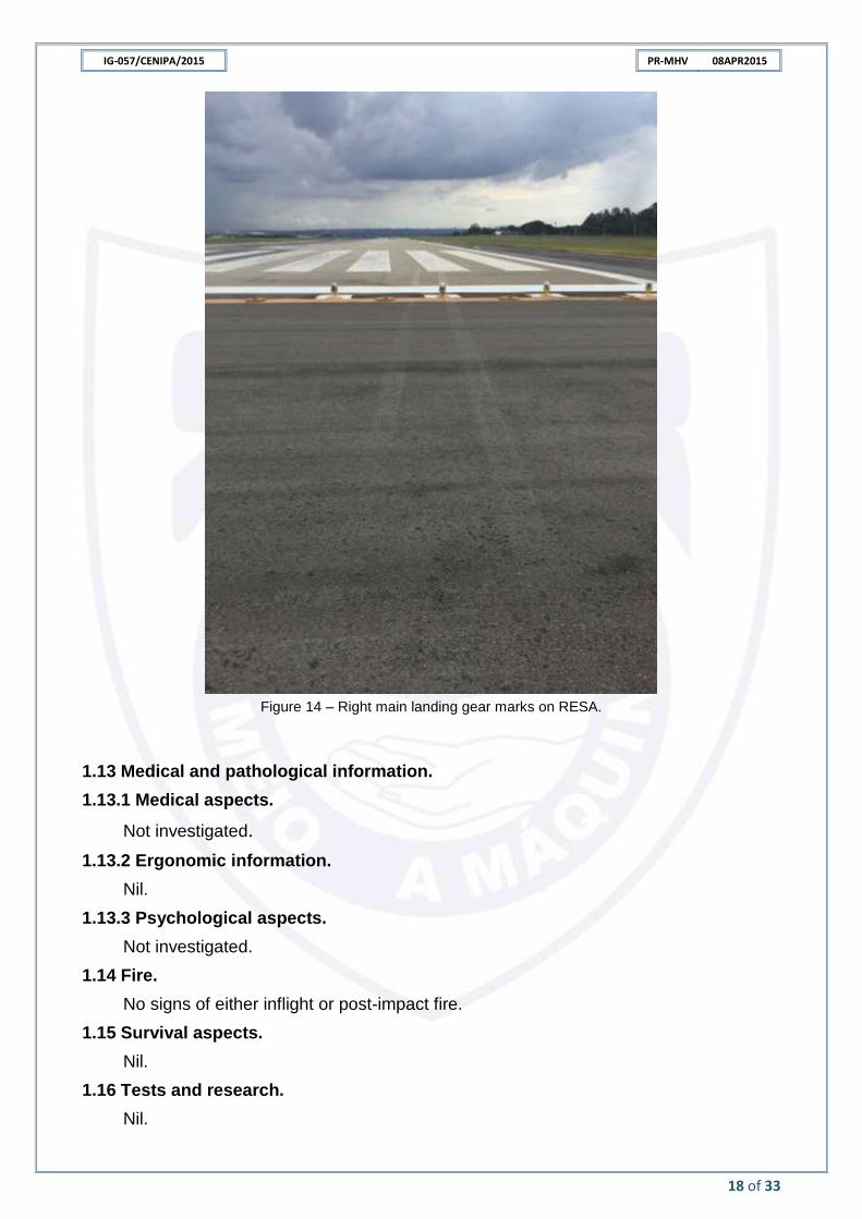
The airplane right landing gear initially touched down at RESA, 13,3m prior to the runway threshold. The left landing gear touched down within the runway limits.
The aircraft rolled a total of 31,5m with the landing gear on the ground.
IG-057/CENIPA/2015 PR-MHV 08APR2015
18 of 33
Figure 14 – Right main landing gear marks on RESA.
1.13 Medical and pathological information.
1.13.1 Medical aspects.
Not investigated.
1.13.2 Ergonomic information.
Nil.
1.13.3 Psychological aspects.
Not investigated.
1.14 Fire.
No signs of either inflight or post-impact fire.
1.15 Survival aspects.
Nil.
1.16 Tests and research.
Nil.
IG-057/CENIPA/2015 PR-MHV 08APR2015
19 of 33
1.17 Organizational and management information.
Nil.
1.18 Operational information.
The aircraft was within the manufacturer prescribed weight & balance limits.
After the aircraft had initiated the descent for landing on runway 11L (SBBR), the Approach Control (APP-BR) reported the runway change and requested PR-MHV to proceed performing RNAV (GNSS) Y RWY 29R.
According to ATS technical documents nº 005/APP-BR/2015 and nº 006/TWR-BR/2015, the APP-BR announced on its frequency that the visibility in SBBR was 3,000m. It was not possible to verify if the PR-MHV crew heard the announcement, although the aircraft radio was tuned in the same frequency.
At 1600 UTC, PR-MHV crew reported they were stabilized on RNAV (GNSS) Y RWY 29R final. The TWR controller immediately asked if the crew had visual contact with the aerodrome, and received a positive answer.
The crew then was cleared for landing on runway 29R, but requested to make an approach for landing on runway 29L. The TWR denied, as there was another traffic for landing on runway 29L at that moment.
PR-MHV crew stated that at MDA (3.880 ft / 401 ft AGL) of RNAV (GNSS) Y RWY 29R procedure, with visual contact with the aerodrome, they disengaged the autopilot and proceeded with visual references, but soon they found light rain that quickly became a heavy rain.
When the crew lost visual contact with the runway, they looked for other references so as they could keep the visual approach. When they realized they had descended the airplane below a proper glidepath to the runway - about 3,521 ft (60 ft AGL) - they initiated the reject landing procedure.
According to FDM data, the aircraft initiated a gradual descent toward the proper glidepath at 3,740 ft (370 ft AGL). At about 3,590 ft (160 ft AGL), the aircraft started flying under the proper glidepath.
About seven seconds elapsed between the airplane flight below the proper glidepath and the beginning of the reject landing procedure.
The crew reported there was no windshear warning.
1.19 Additional information.
FSF-ALAR STUDY
The Flight Safety Foundation (FSF) Approach-and-Landing Accident Reduction (ALAR) task force (issued in November 2000) found that visual approaches were being conducted in 28 percent of 76 approach-and-landing accidents (ALAs) and serious incidents worldwide in 1984 through 1997.
The task force also found that disorientation or visual illusion was a causal factor in 21 percent of the 76 ALAs and serious incidents, and that poor visibility was a circumstantial factor in 59 percent of the accidents and incidents.
According to the task force, the following factors and conditions affect the flight crew’s ability to perceive accurately the environment, resulting in visual illusions.
Airport environment (uphill-sloping terrain or downhill-sloping terrain);
The following weather conditions can create visual illusions:
Ceiling and visibility (vertical, slant and horizontal visibility):
- Flying in light rain, fog, haze, mist, smoke, dust, glare or darkness usually creates an illusion of being too high;
- In light rain or moderate rain, the runway may appear indistinct because of the “rain halo effect”, increasing the risk of misperception of the vertical deviation or horizontal deviation during the visual segment (the segment flown after transition from instrument references to visual references);
- Heavy rain affects depth perception and distance perception:
Rain on a windshield creates refraction effects that cause the crew to believe that the aircraft is too high, resulting in an unwarranted nose-down correction and flight below the desired flight path;
In daylight conditions, rain diminishes the apparent intensity of the approach light system (ALS), resulting in the runway appearing to be farther away. As a result of this illusion, the flight crew tends to shallow the flight path, resulting in a long landing; and,
In nighttime conditions, rain increases the apparent brilliance of the ALS, making the runway appear to be closer, inducing a pitch-down input and the risk of landing short of the runway threshold.
AIRCRAFT INFORMATION - RADAR
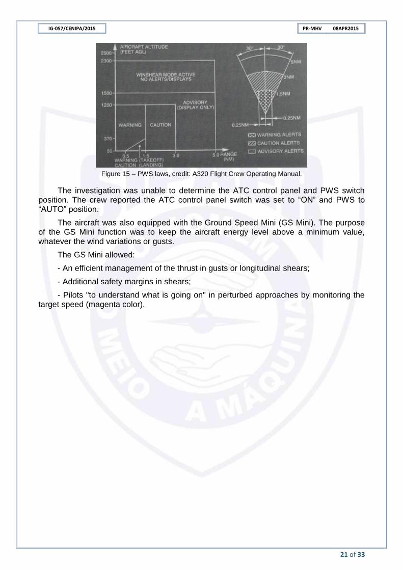
The A320-214 aircraft (PR-MHV) was equipped with a weather radar and the Predictive Windshear System (PWS)
The PWS operated when:
- Its switch was in the “AUTO” position (even if the weather radar is turned off);
- The aircraft was below 2,300 ft AGL;
- The Auto Thrust Control (ATC) was switched to the ON, or AUTO, or XPDR, or XPNDR, position (depending on the ATC panel); and
- Either engine running.
The system scanned the airspace, within a range of 5 NM ahead of the aircraft, for windshears. Below 1500 feet, when the system detects windshear, depending on the range selected on the navigation display (ND), a warning, caution, or advisory message appeared on the ND. Predictive windshear warnings and cautions are associated with an aural warning.
During a final approach, the visual and aural warnings were reclassified as caution alerts between 370 ft AGL and 50 ft AGL, within the range of 0.5 to 1.5NM.
The investigation was unable to determine the ATC control panel and PWS switch position. The crew reported the ATC control panel switch was set to “ON” and PWS to “AUTO” position.
The aircraft was also equipped with the Ground Speed Mini (GS Mini). The purpose of the GS Mini function was to keep the aircraft energy level above a minimum value, whatever the wind variations or gusts.
The GS Mini allowed:
- An efficient management of the thrust in gusts or longitudinal shears;
- Additional safety margins in shears;
- Pilots "to understand what is going on" in perturbed approaches by monitoring the target speed (magenta color).
IG-057/CENIPA/2015 PR-MHV 08APR2015
22 of 33
Figure 16 – Exemple of the GS Mini interpretation. Credit: Flight Crew Training Manual A320.
According to A320 Flight Crew Training Manual, GS Mini variations were effective
means of informing the flight crew of unexpected air mass variations.
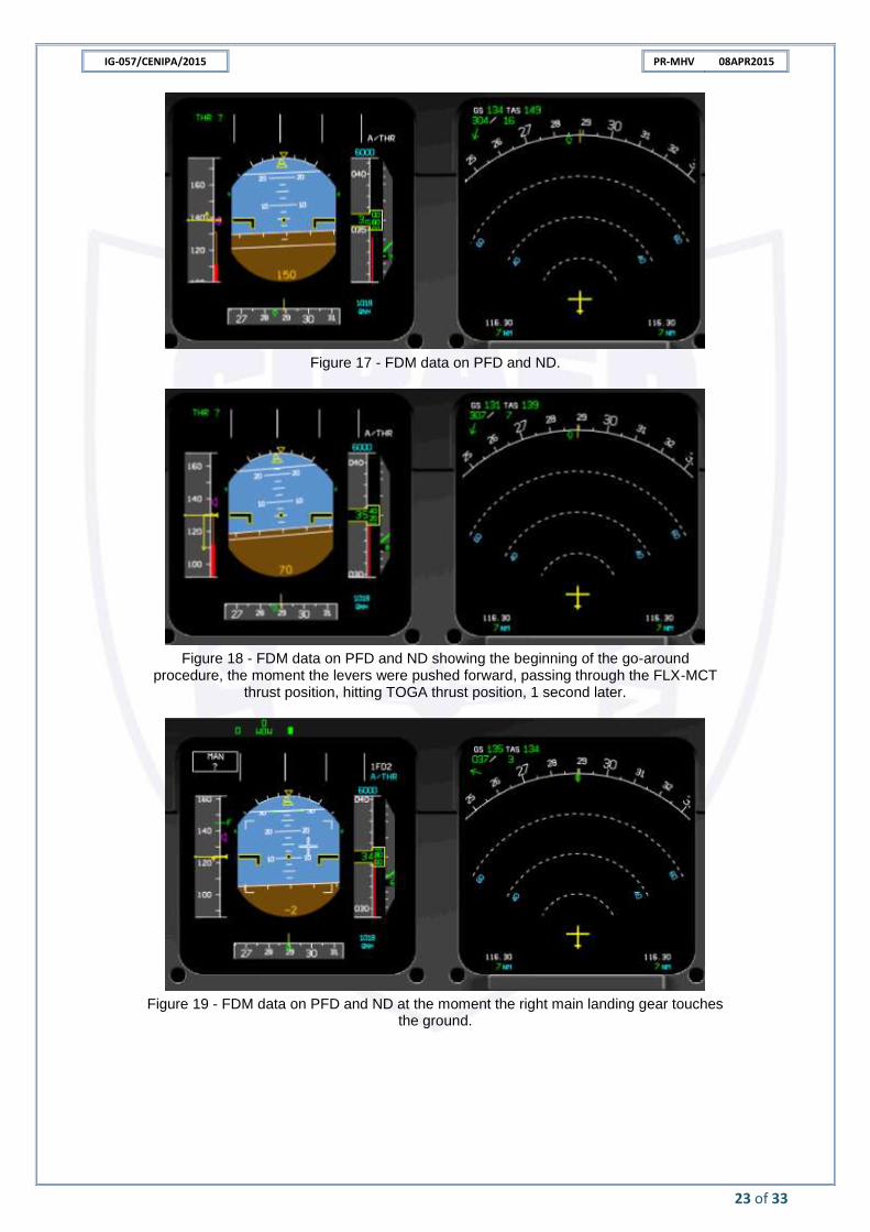
The final phase of the approach (since 150 ft AGL) and go-around procedure (until 130 ft AGL) lasted about 20 seconds. According to FDM data, during this part of the flight, the wind direction varied about 197°, and its intensity varied from 16 kt headwind to 13 kt tailwind.
It was also possible to observe GS Mini variations shortly before the landing (Figures 17 to 21).
IG-057/CENIPA/2015 PR-MHV 08APR2015
23 of 33
Figure 17 - FDM data on PFD and ND.
Figure 18 - FDM data on PFD and ND showing the beginning of the go-around procedure, the moment the levers were pushed forward, passing through the FLX-MCT
thrust position, hitting TOGA thrust position, 1 second later.
Figure 19 - FDM data on PFD and ND at the moment the right main landing gear touches the ground.
IG-057/CENIPA/2015 PR-MHV 08APR2015
24 of 33
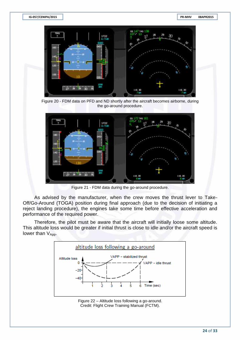
Figure 20 - FDM data on PFD and ND shortly after the aircraft becomes airborne, during the go-around procedure.
Figure 21 - FDM data during the go-around procedure.
As advised by the manufacturer, when the crew moves the thrust lever to Take-Off/Go-Around (TOGA) position during final approach (due to the decision of initiating a reject landing procedure), the engines take some time before effective acceleration and performance of the required power.
Therefore, the pilot must be aware that the aircraft will initially loose some altitude. This altitude loss would be greater if initial thrust is close to idle and/or the aircraft speed is lower than VApp.
Figure 22 – Altitude loss following a go-around. Credit: Flight Crew Training Manual (FCTM).
IG-057/CENIPA/2015 PR-MHV 08APR2015
25 of 33
Flight parameters at the beginning of go-around:
- VApp: 137 kt;
- IAS: 128 kt;
- GSC: 131 kt;
- Flaps: Full;
- Pitch: +6,3º;
- Descent rate: 599 ft/min;
- N1 engine #1: 60,8%; and
- N1 engine #2: 60,8%.
According to PR-MHV FCTM (page NO-180 P1/6), go-around was a mandatory procedure if adequate visual references were not obtained at minima or lost below minima. The FCTM also stated that a temporary landing gear contact with the runway was acceptable (figure 23).
Figure 23 - FCTM A320, page NO-180 P 1/6.
IG-057/CENIPA/2015 PR-MHV 08APR2015
26 of 33
1.20 Useful or effective investigation techniques.
Nil.
ANALYSIS. 2.
SBBR area was surrounded by unstable atmospheric conditions, as verified on meteorological messages and on satellite images.
Convective clouds, such as TCU and isolated CBs, were moving and intensifying above the region.
In accordance with aforementioned forecast information (TAF, SIGMET and GAMET), a METAR report also indicated rainfall, TCU, CB and thunderstorms.
Synoptic conditions and meteorological phenomena at the moment of the occurrence were favorable for rainfall, reduced visibility, strong wind/gusting wind conditions and windshear associated with TCU and CB rainfall.
Shortly before PR-MHV approach, visibility was about 3,000m due to light rain at the airport.
During the final approach, below the Minimum Descent Altitude (MDA), with visual references for runway 29R, the crew decided to disengage the autopilot and continue the approach using visual references.
Closer to the runway, the crew encountered light rain conditions that quickly became heavy rain. It was not possible to determine the exact moment the crew lost visual contact with the runway. However, the investigation could verify that, at 3,740 ft/370 ft AGL, PR-MHV descent rate increased gradually, and at 3,590 ft/160 ft AGL the aircraft was below the glide slope.
It is likely that the glide path gradual descent was due to the visual illusion caused by the rain on the aircraft windshield and further loss of visual contact with the runway.
After losing visual references and realizing the aircraft was below the correct glide path, the crew decided to go around. On this moment, the aircraft was about 3,521 ft/60 ft AGL.
Considering the terrain relief prior to the threshold 29R and the TDZE altitude, PR-MHV was about 41ft height (in relation to the runway) at the moment the crew initiated the go-around.
As prescribed by the manufacturer on FCTM, the aircraft loses some altitude during a go-around until the development of the required power by engines. It also states that a temporary landing gear contact with the runway is acceptable.
This altitude loss would be greater if initial thrust was close to idle and/or the aircraft speed was lower than VApp.
It is possible that, in addition to the predicted loss of altitude, a light windshear/downburst arriving at the airport area had favored the touchdown prior to the runway threshold.
The PWS likely did not emit any warning because the aircraft was near the detection limit.
GS Mini variations and the wind intensity and direction variations in the final moments of approach are other clues of the meteorological phenomenon (windshear/downburst).
IG-057/CENIPA/2015 PR-MHV 08APR2015
27 of 33
CONCLUSIONS. 3.
3.1 Facts.
a) The pilots had valid Aeronautical Medical Certificate;
b) the pilots had valid technical qualification certificate, and had considerable experience in the type of flight;
c) the aircraft had valid Airworthiness Certificate;
d) the aircraft was within the weight & balance limits;
e) the airframe and engine logbooks records were up-to-date;
f) the visibility at SBBR was about 3,000m during the PR-MHV approach due to rain in that moment.
g) there was a meteorological scenario of prospective windshear;
h) the operator only recognized the occurrence on 10APR2015. Thus, the aircraft made further flights, and other new data was recorded over the occurrence data.
i) PR-MHV crew executed the RNAV (GNSS) Y approach to runway 29 R;
j) PR-MHV got caught in a light rain during the final approach;
k) the aircraft descended below the proper glidepath;
l) the crew lost visual contact with the runway in an undetermined moment of the approach;
m) the crew initiated the go-around at 3,521ft/60ft AGL, 41ft above THR 29R TDZE;
n) the aircraft touched down prior to the runway threshold, and struck one of the threshold lights.
o) the aircraft sustained minor damage; and
p) none of the occupants was injured.
3.2 Contributing factors.
- Visual illusions – undetermined.
It is possible that crew sensory impressions were affected by the rain at the final approach. Thus, crew can have recognized the runway position (vertically or horizontally) wrongly while they had visual references.
- Influence from the environment – a contributor.
The crew lost visual contact with the runway due to reduced visibility caused by heavy rain.
It is also possible that a low-level light windshear/downburst affected the aircraft glidepath.
- Piloting judgment – undetermined.
It is possible that the crew had initiated a late go-around in the attempt to reestablish visual contact with the runway.
However, the crew initiated the reject landing procedure at 41ft height in relation to RWY 29R TDZE.
IG-057/CENIPA/2015 PR-MHV 08APR2015
28 of 33
SAFETY RECOMMENDATION. 4.
A measure of preventative/corrective nature issued by a SIPAER Investigation Authority
or by a SIPAER-Link within respective area of jurisdiction, aimed at eliminating or mitigating
the risk brought about by either a latent condition or an active failure. It results from the
investigation of an aeronautical occurrence or from a preventative action, and shall never be
used for purposes of blame presumption or apportion of civil, criminal, or administrative liability.
In consonance with the Law n°7565/1986, recommendations are made solely for the
benefit of the air activity operational safety, and shall be treated as established in the NSCA 3-13
“Protocols for the Investigation of Civil Aviation Aeronautical Occurrences conducted by the
Brazilian State”.
Recommendations issued at the publication of this report:
To the Brazil’s National Civil Aviation Agency (ANAC):
IG-057/CENIPA/2015 - 01 Issued on 12/19/2018
To encourage the operator to work on the importance of warning crews about possibility of visual illusions during flights in rain conditions.
IG-057/CENIPA/2015 - 02 Issued on 12/19/2018
To encourage the operator to reinforce the reject landing maneuvers training (in flight simulators) in condition similar to the occurrence.
CORRECTIVE OR PREVENTATIVE ACTION ALREADY TAKEN. 5.
The operator instructed the crews to always contact the Safety of the company as soon as possible in case of any flight event that can be considered an aeronautical occurrence.
Examples of aeronautical occurrences that must be reported to the Safety (by means of Mandatory Report) were depicted at the company`s General Manual of Operations.
On December 19th, 2018.
IG-057/CENIPA/2015 PR-MHV 08APR2015
29 of 33
ANNEX A
IG-057/CENIPA/2015 PR-MHV 08APR2015
30 of 33
COMMENTS BY THE BEA
Below, there is a list of all the comments forwarded by the Bureau d'Enquêtes et d'Analyses pour la Sécurité de l'Aviation Civile – BEA.
COMMENT 1
Regarding Section “1.1”, page 7.
…the crew decided to conduct the flight in VMC.
Text proposed by BEA:
“… the crew performed the flight in VMC” or “… the crew performed a visual approach.
BEA´s comment:
The crew can perform the IFR flight and follow the approach in VMC. Do you mean that the crew decided to perform a visual approach as they were in VMC conditions or that they continued the GNSS approach under MDA as they had acquired visual references? To improve clarity of the flight history, could you add information about the fact that the crew was following a GNSS approach before switching to visual approach?
CENIPA´s comment:
We wanted to say that the crew continued the final approach of the GNSS procedure, under MDA, with visual references. The text was changed to:
On the final approach of RNAV (GNSS) Y procedure, for landing on runway 29R at SBBR, when passing the MDA (3.880 ft / 401ft AGL) and with the runway in sight, the autopilot was disengaged and the crew continued to land with visual references, until they encountered light rain conditions that quickly became a heavy rain. They lost visual contact with the runway, and could not complete the approach.
COMMENT 2
Regarding Section “1.1”, page 7.
They lost the visual contact with the runway, and could not complete the approach in VMC.
Text proposed by BEA:
“… and could not carry on a visual approach”
BEA´s comment:
Do you means that when they lost visual references they decided to abort the visual approach?
CENIPA´s comment:
As they lost the visual references, they abort the land. They were not performing a visual approach.
COMMENT 3
Regarding Section “1.1”, page 7.
The crew flew another traffic pattern and made a safe final landing.
Text proposed by BEA:
NIL
BEA´s comment:
IG-057/CENIPA/2015 PR-MHV 08APR2015
31 of 33
You may explain the kind of approach they performed after the rejected landing: visual approach, visual manoeuver or other.
CENIPA´s comment:
The text was changed to:
The crew performed another RNAV (GNSS) Y procedure and made a safe final landing.
COMMENT 4
Regarding Section “1.5.4”, page 9. Qualification and flight experience.
Text proposed by BEA:
NIL
BEA´s comment:
You may add information about their experience and training in visual approach or manoeuver.
CENIPA´s comment:
The CENIPA believes that this kind of information is not necessary, since they were not performing a visual approach.
COMMENT 5
Regarding Section “1.7”, page 11/12. Figure 4 and 5.
Text proposed by BEA:
NIL
BEA´s comment:
I suggest you add SBBR location on the weather satellite image.
CENIPA´s comment:
The SBBR location was added.
COMMENT 6
Regarding Section “1.18”, page 19.
NIL
Text proposed by BEA:
NIL
BEA´s comment:
The paragraph is a little confusing. The crew was following a GNSS approach to runway 29R and decided to continue the approach under MDA as they acquired visual references to the runway. They were then performing a visual manoeuver. Visual manoeuver does not require VMC conditions but visual references to the runway. Did they really decide to shift to a visual approach?
By VMC conditions does the crew mean visual references?
CENIPA´s comment:
The text was changed to:
PR-MHV crew stated that at MDA (3.880 ft / 401 ft AGL) of RNAV (GNSS) Y RWY 29R procedure, with visual contact with the aerodrome, they disengaged the autopilot and
IG-057/CENIPA/2015 PR-MHV 08APR2015
32 of 33
proceeded with visual references, but soon they found light rain that quickly became a heavy rain.
COMMENT 7
Regarding Section “1.18”, page 19. Line 2.
Text proposed by BEA:
Aircraft
BEA´s comment:
Aicraft/typo
CENIPA´s comment:
The word was corrected.
COMMENT 8
Regarding Section “1.18”, page 19. Line 21 - The reject landing procedure.
Text proposed by BEA:
NIL
BEA´s comment:
Which procedure is referred to? Was the crew supposed to apply TOGA thrust? Referring to page 23, figure 18, it appears that they applied MCT/flex instead.
CENIPA´s comment:
The FDM data showed that the crew applied TOGA thrust during the reject landing procedure. The Figure 18 was used to show the wind direction in the beginning of the missed approach procedure, when the thrust levers passed through the MCT/Flex thrust position toward the TOGA thrust position, to compare with the wind direction in others phases of the reject landing. This was used to show the windshear possibility.
To avoid any misunderstanding, the picture’s subtitle was changed to:
Figure 18 - FDM data on PFD and ND showing the beginning of the go-around procedure, the moment the levers were pushed forward, passing through the FLX-MCT thrust position, hitting TOGA thrust position, 1 second later.
COMMENT 9
Regarding Section “1.19”, page 19.
Text proposed by BEA:
NIL
BEA´s comment:
ALAR task force is referring to visual approaches. Confirm the crew was performing a visual approach?
CENIPA´s comment:
Besides the ALAR task force refers to visual approaches, they explain the illusion effects that could have happened in this case, from the moment the pilots made the transition of instrument flight to the flight with visual references.
IG-057/CENIPA/2015 PR-MHV 08APR2015
33 of 33
COMMENT 10
Regarding Section “1.19”, page 19.
Text proposed by BEA:
NIL
BEA´s comment:
I suggest you explain the meaning of ATC system (Auto Thrust Control different from Air Traffic Control).
CENIPA´s comment:
The meaning of ATC was added to the text and to the Glossary.
COMMENT 11
Regarding Section “2”, page 26.
“…the crew decided to disengage the autopilot and proceed the approach in VMC.”
Text proposed by BEA:
“…the crew decided to disengage the autopilot and continue the approach using visual references.”
BEA´s comment:
VMC corresponds to weather conditions, not to an operational phase of the flight.
CENIPA´s comment:
The text was changed as suggested.
COMMENT 12
Regarding Section “3.1”, page 27, item “m”.
The crew initiated a go around.
Text proposed by BEA:
NIL
BEA´s comment:
As reminded page 24 of the CENIPA report, the manufacturer advises to select TOGA detent to perform a go-around.
From figure 18 page 23, it appears that the crew did not apply the correct procedure to perform a go around. Airbus nor BEA were given access to FDM data so it is difficult to assess its impact.
If the crew selected MCT instead of TOGA, it was certainly a contributing factor to the event and should be addressed in safety recommendations as well.
CENIPA´s comment:
As explained in comment 8, the TOGA thrust was used during the missed approach procedure. The FDM data showed this.
To avoid any misunderstanding, the picture’s subtitle was changed to:
Figure 18 - FDM data on PFD and ND showing the beginning of the go-around procedure, the moment the levers were pushed forward, passing through the FLX-MCT thrust position, hitting TOGA thrust position, 1 second later.