102
FINDING OF SUITABILITY FOR EARLY TRANSFER (FOSET) RIVERBANK ARMY AMMUNITION PLANT RIVERBANK, CALIFORNIA Remainder Parcel A and Evaporation/Percolation Ponds January 2010

FINDING OF SUITABILITY FOR EARLY TRANSFER (FOSET)
RIVERBANK ARMY AMMUNITION PLANT
RIVERBANK, CALIFORNIA
Remainder Parcel A and Evaporation/Percolation Ponds
January 2010

ii
CONTENTS
1.0 INTRODUCTION..............................................................................................................6
1.1 Responsibility for Remedial and Corrective Actions, and Land Use Controls 7 1.2 Response Action Schedule .....................................................................................7
2.0 PROPERTY DESCRIPTION ...........................................................................................8
3.0 ENVIRONMENTAL DOCUMENTATION ...................................................................8
4.0 ENVIRONMENTAL CONDITION OF PROPERTY ...................................................8
4.1 Environmental Condition of Property Categories ..............................................8 4.2 Environmental Remediation Sites ........................................................................9
4.2.1 Groundwater Contamination (RBAAP-03) .............................................9 4.2.2 Landfill (RBAAP-01; SWMUs 10 and 11) .............................................10 4.2.3 Industrial Wastewater Treatment Plant (SWMU 1) ............................11
4.3 Storage, Release, and Disposal of Hazardous Substances ................................12 4.4 Petroleum and Petroleum Products ...................................................................12
4.4.1. Underground Storage Tanks (USTs) and Above-Ground Storage Tanks (ASTs) ........................................................................................................12 4.4.2. Non-UST/AST Storage, Release, or Disposal of Petroleum Products ..13
4.5 Polychlorinated Biphenyls ..................................................................................13 4.6 Asbestos-Containing Materials ...........................................................................13 4.7 Lead and Lead-Based Paint (LBP) .....................................................................14 4.8 Radioactive Material ...........................................................................................14 4.9 Radon ....................................................................................................................14 4.10 Munitions and Explosives of Concern (MEC) ..................................................14 4.11 Other Identified Concerns ..................................................................................15
5.0 ADJACENT PROPERTY CONDITIONS ....................................................................15
6.0 ENVIRONMENTAL REMEDIATION AGREEMENTS ...........................................16
7.0 REGULATORY/PUBLIC COORDINATION AND COMMENTS...........................16
8.0 NATIONAL ENVIRONMENTAL POLICY ACT (NEPA) COMPLIANCE ...........17
9.0 ENVIRONMENTAL PROTECTION PROVISIONS .................................................17
10.0 STATE LAND USE CONTROLS ..................................................................................17
11.0 DEFERRED WARRANTY.............................................................................................18
12.0 FINDING OF SUITABILITY FOR EARLY TRANSFER .........................................19
iii
CONTENTS (continued)
Figures 1 Vicinity Map 2 Parcel Map 3 IRP Sites, SWMUs, and AOCs 4 Well Locations 5 Above Ground Storage Tanks 6 Under Ground Storage Tanks 7 Property Categorization Map 8 Land Use Restrictions 9 Groundwater Use Restrictions Plate 1: RBAAP A/A’ Aquifer Zone Groundwater Elevation Contours with Third Quarter
2009 Chromium and Cyanide Concentrations
Plate 2: RBAAP B Aquifer Zone Groundwater Elevation Contours with Third Quarter 2009 Chromium and Cyanide Concentrations
Plate 3: RBAAP C Aquifer Zone Groundwater Elevation Contours with Third Quarter 2009 Chromium and Cyanide Concentrations
ENCLOSURES
Enclosure 1 – Environmental Documentation Enclosure 2 – Figures Enclosure 3 – Table 1 – Environmental Conditions of the Property Enclosure 4 – Table 2 – Notification of Hazardous Substance Storage, Release, or Disposal Enclosure 5 – Table 3 – Notification of Petroleum Product Storage, Release, or Disposal Enclosure 6 – Table 4 – PCB and PCB-Contaminated Transformers Enclosure 7 – CERCLA Notice, Covenant, Access Provisions and Deed Restrictions Enclosure 8 – Environmental Protection Provisions Enclosure 9 – Public Notice Enclosure 10 – Responsiveness Summary

iv
ACRONYMS
µg/L Micrograms per liter ACM Asbestos containing material AOC Area of Concern AST Aboveground storage tank bgs Below ground surface BRAC Base Realignment and Closure CACA Corrective Action Consent Agreement CERCLA Comprehensive Environmental Response, Compensation and Liability Act CERFA Community Environmental Response Facilitation Act CFR Code of Federal Regulation cy cubic yards DMM Discarded Military Munitions DoD Department of Defense DTSC Department of Toxic Substances Control EBS Environmental Baseline Survey ECP Environmental Condition of Property E/P Evaporation/Percolation EPA U.S. Environmental Protection Agency EPP Environmental Protection Provision ESD Explanation of Significant Differences FOSET Finding of Suitability for Early Transfer FOST Finding of Suitability for Transfer Gpm Gallons per minute GWTP Groundwater Treatment Plant IPRG Industrial Preliminary Remediation Goals IRP Installation Restoration Program IWTP Industrial Wastewater Treatment Plant LBP Lead based paint LUC Land use control MCL Maximum Contaminant Level MEC Munitions and explosives of concern mg/kg Milligrams per kilogram mg/L Milligrams per liter MMRP Military Munitions Response Program NPDES National Pollution Discharge Elimination System NPL National Priorities List PBA Performance Based Acquisition PCB Polychlorinated biphenyl

Acronyms (continued)
v
pCi/L Picocuries per liter POTW Publicly Owned Treatment Works ppm parts per million ppb parts per billion PRG Preliminary Remediation Goal RBAAP Riverbank Army Ammunition Plant RCRA Resource Conservation and Recovery Act RI Remedial Investigation RLRA Riverbank Local Redevelopment Authority ROD Record of Decision RLRA Riverbank Local Redevelopment Authority SI Site Investigation SVOC Semi-volatile organic compound SWMU Solid Waste Management Unit TSCA Toxic Substances Control Act USACE U.S. Army Corps of Engineers UST Underground storage tank UXO Unexploded ordinance VOC Volatile organic compound WDR Waste Discharge Requirements

6
FINDING OF SUITABILITY FOR EARLY TRANSFER (FOSET) RIVERBANK ARMY AMMUNITION PLANT
Remainder Parcel A and Evaporation/Percolation Ponds
January 2010
1.0 INTRODUCTION
The purpose of this Finding of Suitability for Early Transfer (FOSET) is to document the environmental suitability of certain parcels at the Riverbank Army Ammunition Plant (hereinafter referred to as the “Property”) for early transfer consistent with the Comprehensive Environmental Response, Compensation, and Liability Act (CERCLA) Section 120(h)(3)(C). CERCLA Section 120(h)(3) requires the United States to provide a covenant in the deed conveying the property warranting that all remedial action necessary to protect human health and the environment has been taken prior to the date of transfer. For a Federal facility listed on the U.S. Environmental Protection Agency (EPA) National Priorities List (NPL), CERCLA Section 120(h)(3)(C) allows the EPA Administrator, with the concurrence of the Governor of the State, to defer the CERCLA covenant requirement. These types of transfers under CERCLA Section 120(h)(3)(C) are typically called “Early Transfers,” in which the United States will provide the warranty after transfer of the property when all the response actions necessary to protect human health and the environment have been taken. The period between the transfer of title and delivery of this final warranty is known as the “deferral period.” The intent of the Early Transfer is to facilitate efforts to stimulate the economy through productive reuse of the property while final remediation work is conducted.
The EPA Administrator, with the concurrence of the Governor of the State in which the property is located, may defer the CERCLA warranty requirement if they determine that the property is suitable for transfer on the basis of the following findings:
1) The property is suitable for transfer for the use intended by the transferee, and the intended use is consistent with protection of human health and the environment;
2) The deed or other agreements proposed to govern the transfer between the United States and the recipient of the property contains the assurances set forth in CERCLA Section 120(h)(3)(C)(ii), including: (1) the protection of human health and the environment; (2) no disruption of any pending or ongoing response actions or corrective actions, or oversight activities; (3) provision for schedules for investigation and completion of response actions; and (4) the use of covenants/restrictions, as specified in the attached CERCLA Notice, Covenant, Access Provisions and Deed Restrictions (Enclosure 7), the attached Environmental Protection Provisions (EPPs) (Enclosure 8), and the State Land Use Controls (SLUCs) necessary to protect human health and the environment after the Early Transfer, and to prevent interference with any existing or planned environmental restoration activities;
3) The Federal agency requesting the deferral has provided notice, by publication in a newspaper of general circulation in the vicinity of the property, of the proposed transfer

7
and of the opportunity for the public to submit, within a period of no less than 30 days after the date of the notice, written comments on the suitability of the property for transfer;
4) The deferral and transfer of the property will not substantially delay any necessary response actions at the property.
In addition, the Department of Defense (DoD) and United States Department of Army (Army) policy requires that the Military Department proposing to transfer property prepare a FOSET. This FOSET will be submitted as part of the Covenant Deferral Request, in which the Army will seek approval by the EPA Administrator and concurrence by the Governor of the State California.
1.1 Responsibility for Remedial and Corrective Actions, and Land Use Controls
The Army will complete all necessary remediation of the Property, including remediation of contaminated groundwater, groundwater monitoring, and long-term monitoring of the landfill cap. Operation of the groundwater treatment system or other approved alternative approach will continue until the remedial goals described in the Record of Decision (U.S. Army Environmental Center (USAEC), 1994) are attained. An Explanation of Significant Difference (ESD) is currently being written to implement in-situ treatment of the groundwater plume. The Army will also continue to evaluate optimization actions for the monitoring program along with long-term maintenance of the landfill cap for the life of the permit requirements.
To protect human health and/or the environment after the Early Transfer and to prevent interference with any existing or planned environmental restoration activities, the Riverbank Local Redevelopment Authority (RLRA) will be required to implement Land Use Controls (LUCs) in accordance with the reuse covenants and restrictions specified in the CERCLA Notice, Covenant, Access Provisions and Deed Restrictions (Enclosure 7); the EPPs (Enclosure 8); and the SLUCs. These LUCs will be in effect until the provisions in the deeds and SLUCs are either terminated, removed, or modified, as specified in an appropriate CERCLA decision document, and protectiveness of human health and the environment can be assured by the modified LUCs or additional LUCs, if necessary
1.2 Response Action Schedule
The Riverbank Army Ammunition Plant (RBAAP) is on the NPL. As required under CERCLA Section 120, the Army, the EPA Region 9, the California Department of Toxic Substances (DTSC), and the Central Valley Regional Water Quality Control Board (Central Valley Water Board) entered into a Federal Facility Agreement (FFA), which became effective June 1990. All necessary response actions will be taken in accordance with the schedule provided in the FFA. This schedule will not substantially delay any necessary response actions at the property.
Changes to the schedule may occur as a result of such things as additional sampling requirements that have not been identified; discovery of additional contamination on the property; unanticipated conditions during field efforts; and additional review and revision of documentation such as reports, work plans, designs, etc. Such changes to the schedule will be made in accordance with the FFA.

8
2.0 PROPERTY DESCRIPTION
The RBAAP is located at 5300 Claus Road, Riverbank, Stanislaus County, California, one mile south of the Stanislaus-San Joaquin County border and approximately five miles northeast of the city of Modesto (Enclosure 2, Figure 1). The RBAAP occupies a total of 173 acres of land and consists of two noncontiguous areas represented by the main plant area (approximately 146 acres) and the evaporation/percolation (E/P) ponds (28.8 acres). In general, the plant production area is mostly paved and consists of one active manufacturing line, areas containing laid away equipment, process water/groundwater treatment facilities and various buildings used for maintenance, leased industrial operations, administration, and storage.
The Property for Early Transfer consists of the E/P ponds (28.8 acres) and Remainder Parcel A, described below (approximately 76.2 acres). The four E/P ponds are approximately 1.5 miles north of the RBAAP boundary along the Stanislaus River and receive treated water from the industrial wastewater treatment plant (IWTP) and the groundwater treatment plant (GWTP). The effluent is discharged to the bermed ponds and evaporates or percolates through the existing sediments to groundwater. Of the 146 acres of the main plant area, Reminder Parcel A constitutes approximately 76.2 acres at the center of the installation that is comprised primarily of the manufacturing area, the landfill, and IWTP (Enclosure 2, Figure 2).
3.0 ENVIRONMENTAL DOCUMENTATION
A determination of the environmental condition of the Property was made based upon the U.S. Army BRAC 2005, Environmental Condition of Property Phase I Report, Riverbank Army Ammunition Plant, Riverbank, CA, Final, 17 November 2006 (hereinafter referred to as the “ECP Report”) and the Final Site Investigation Report, Riverbank Army Ammunition Plant, March 2008. The information provided is a result of a complete search of agency files during the development of these environmental surveys. These documents delineate all environmental conditions and remedial decisions for RBAAP.
A complete list of documents providing information on environmental conditions of the Property is compiled in Enclosure 1.
4.0 ENVIRONMENTAL CONDITION OF PROPERTY
The following sections summarize the environmental investigations and remedial actions completed to date at RBAAP.
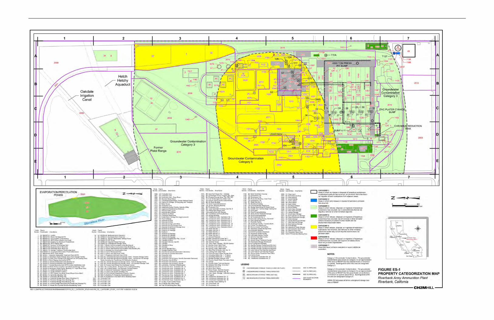
4.1 Environmental Condition of Property Categories
The ECP Report identified ECP Categories for the Property. Since that time, subsequent environmental investigations have been completed, including the Site Investigation (SI) Report (CH2M HILL, 2008). As a result, some of the ECP Categories have been updated. A summary of the current ECP Categories for specific areas, or operable units, and the ECP Category definitions is provided in Table 1 – Environmental Condition of the Property (Enclosure 3 and Figure 7).
9
4.2 Environmental Remediation Sites
There are seven remediation sites located on the Property. A summary of the environmental remediation sites on the Property is as follows:
• Groundwater Contamination (RBAAP-03) • Landfill (RBAAP-01; SWMUs 10 and 11) • Industrial Wastewater Treatment Plant (SWMU 1) • Southeast Storm Reservoir (RBAAP-08/SWMU 21/AOC 16): • E/P Ponds (RBAAP-11/SWMU 23): • Horizontal ASTs – Transformer Oil Storage Tanks (including Transformer Oil
Distribution System) (AOC 8B) • Draw Lube System (Building 178) (AOC 13)
All environmental sites are located on Remainder Parcel A with the exception of the E/P Ponds (RBAAP-11/SWMU 23), which are located on the E/P Ponds parcel.
All environmental remediation activities at the landfill, the Southeast Storm Reservoir, the E/P Ponds, the Horizontal ASTs, and the Draw Lube System have been completed. The Property was not remediated to levels suitable for unrestricted use. The deed will include the following land use restrictions: no use of groundwater, no residential use, and no soil disturbance of the landfill cap.
Remediation activities are ongoing for the groundwater contamination (See Section 4.2.1). Long-term maintenance is ongoing at the landfill (see Section 4.2.2). Further investigation is required at the Industrial Wastewater Treatment Plant (see Section 4.2.3).
A complete summary of the environmental investigation and remediation sites is provided in Table 2 –Notification of Hazardous Substance Storage, Release, or Disposal (Enclosure 4).
4.2.1 Groundwater Contamination (RBAAP-03) The IRP Site RBAAP-03 contains chromium and cyanide groundwater contamination resulting from leakage associated with the original IWTP. The original IWTP at RBAAP was constructed to treat the wastewaters generated from the electroplating, cleaning, and metal finishing processes that are operated on-site. The original storage and equalization tanks used for the IWTP were made of redwood, which would occasionally leak. From 1973 to 1980, the IWTP was upgraded and the redwood tanks were replaced with concrete tanks. The upgraded IWTP, identified as SWMU 1, continues to operate under a RCRA Part B Permit 05-SAC-06.
In 1985, groundwater samples from six wells located west of the RBAAP showed levels of chromium in excess of the Maximum Contaminant Level (MCL) of 50 micrograms per liter (μg/L). As a result, the Army installed an interim groundwater treatment system (GWTS) and provided bottled drinking water to those affected residents followed by the extension of the Riverbank city water system to all potentially affected residents. The original IWTP redwood tank area was identified as the major source of chromium contamination. The EPA added the RBAAP to the NPL on Feb. 21, 1990, primarily due to the presence of groundwater contamination (cyanide and chromium) detected on and off-post.

10
The groundwater contamination was included in the site-wide ROD (USAEC, 1994). The ROD required expansion of the interim GWTS to fully capture groundwater contamination. The expanded system began operation in 1997 and is now capturing all contaminated groundwater and removing contamination from the extracted water by means of ion exchange. The cleanup goals for chromium and cyanide are 50 μg/L and 200 μg/L, respectively. The treated groundwater is discharged to the E/P Ponds.
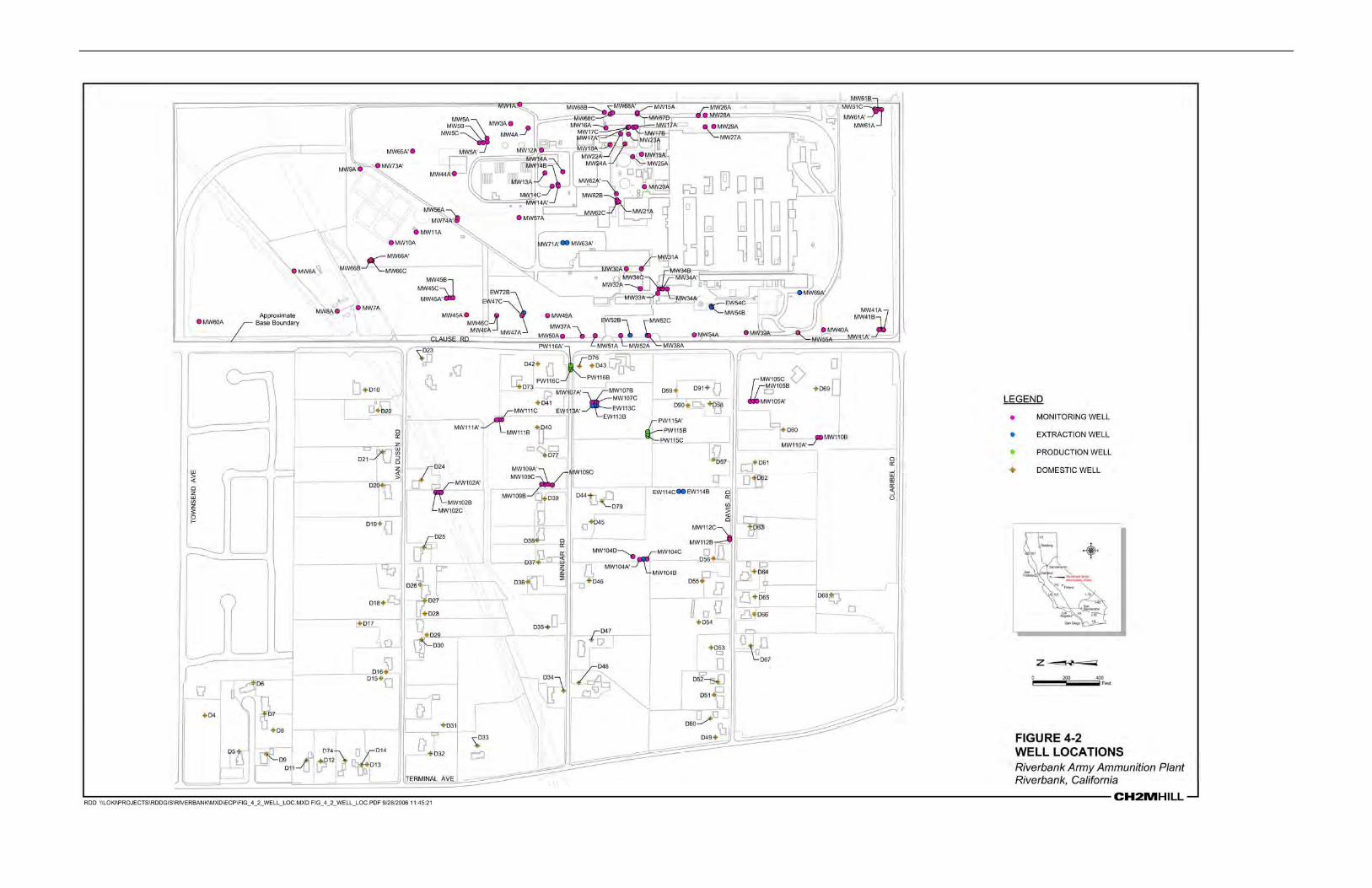
Groundwater monitoring consists of four sampling events per year; two quarterly, one semiannual and one annual which include specific sets of wells completed in the various A', A, B, C and D portions of the aquifer. The locations of the monitoring wells is shown in Enclosure 2, Figure 4. The results of the groundwater sampling from the third quarter of 2009 are shown on Plates 1, 2, and 3 (AHTNA, 2009).
The Army believes the current remedial action captures all contaminated groundwater and is protective of human health and the environment. There is chromium contamination exceeding the MCL in the furthest down-gradient monitoring well (MW104C). However, the furthest down-gradient extraction well (EW104B) is currently in operation and is maintaining capture of this area of contamination. Unpublished Fourth Quarter 2009 analytical data indicates this by showing a decline in chromium concentrations in the area.
The Army completed the first Five Year Review in February 2001 (Army, 2001) and the second Five Year Review in September 2006 (AHTNA, 2006). Both Five Year Reviews concluded that the groundwater remedy was functioning as intended and was protective of human health and the environment.
In September 2007, the Army initiated, with regulatory approval, a one-year shutdown of the groundwater pump and treatment system to study rebound effects. It also conducted an in situ pilot test of ferrous iron and carbon to determine if this could result in an alternative treatment of residual hexavalent chromium in the groundwater. As part of this effort, the Army installed four new monitoring wells (117, 118, 119, and 120) to be included in the monthly monitoring of rebound effects. The localized contamination and plume stability indicated by the results of the Rebound Study support localized in situ treatment for the remaining areas of chromium contamination. The results of the in situ pilot test demonstrated that reductant injections rapidly reduced dissolved chromium concentrations by precipitating chromium.
The Army is currently preparing an Explanation of Significant Differences (ESD) to conduct in-situ treatment to address chromium. The Army is also working on the development of an ESD to address institutional controls. Remedial actions at RBAAP-03 will continue until remedial goals have been reached.
4.2.2 Landfill (RBAAP-01; SWMUs 10 and 11) RBAAP-01 is approximately 4.5 acres and is located in the northern section of the main plant near the eastern boundary. The landfill was the site of surface and trench disposal and burning from 1942 to 1966. The disposal operations in this area did not involve typical landfill operations, but consisted of two discrete disposal trenches and a surface disturbance area. According to records from 1942 to 1966, the landfill at the RBAAP was used for the incineration and disposal for paper, dunnage, oils, grease, solvents, hospital wastes, construction debris, and

11
industrial sludges. In 1966, onsite disposal operations were discontinued, and the area was filled with dirt and construction rubble. Wells placed downgradient of the landfill have indicated that the landfill was a possible source of cyanide and chromium contamination in groundwater. Cyanide contamination has been potentially linked to pot liner from aluminum reduction processes, a RCRA-listed waste, and has been found in the southern portion of the landfill. Most of the pot liner was removed during previous rubble removal efforts. Chromium contamination was also traced to construction rubble, which contained chromium-contaminated bricks. All surface debris, including chromium-contaminated bricks, was removed as part of a 1987 rubble cleanup effort.
The Army installed and maintains a clay cap at the landfill. The final site-wide 1994 ROD documents this remedial action selection. Implementation of the landfill remedial action began in June 1995 and initial work was completed in October 1995. Additional seeding was performed in 1996 with the final landfill cover including, from top to bottom, a two-foot-thick vegetative cover layer, a one-quarter-inch-thick geosynthetic liner, and a two-foot-thick foundation layer. The landfill cap was designed and constructed to drain rainfall off and away from the landfill. After installation of the cap and associated drainage and final grading, the cover was hydro-seeded with native grass. Some damage was caused in 1997 by construction activity on the adjoining railroad tracks. This was noted in the first Five Year Review and repairs were made.
The second Five Year Review was completed in November 2006, and the remedy was found to be effective. To ensure continued protectiveness, the site requires land use controls described in Section 10.0.
Annual surveys to assure stability and annual management of a pesticide program to prevent damage to the completed landfill cap are being conducted.
4.2.3 Industrial Wastewater Treatment Plant (SWMU 1) The IWTP is a treatment facility for industrial wastewater generated at the installation from electroplating, cleaning, and metal finishing processes. The primary treatment technologies are coagulation, flocculation, and clarification. The IWTP is located to the immediate north of the production plant at the installation. Treated effluent water is discharged to the E/P Ponds.
The IWTP was originally built after the Army acquired the facility in 1951. From 1952 to 1954, production lines 5 and 6 produced zinc-plated shells for the Navy. Because the zinc was electroplated from a cyanide solution, a separate system was required to treat waste from this area. Cyanide solutions were diverted to a special tank in the IWTP where chlorine was added for neutralization. The neutralized cyanide waste joined the normally treated waste and both were transported to the E/P Ponds. The cyanide treatment tanks have not been in use since 1954.
Since 1972, numerous upgrades and improvements have been implemented at the IWTP. The redwood equalization tanks were replaced with a concrete equalization basin in 1980. Reportedly, when the water level in the redwood tanks was reduced for a period, the upper portion of the redwood tanks would dry out and the seams would open slightly. When the liquid level was later raised, the upper portion of the redwood tanks would leak and spill onto the adjacent ground, which was not paved at the time. This is believed to be the source of the

12
chromium and cyanide contamination in the IWTP area. The entire IWTP area is now covered with concrete or asphalt. A series of concrete drainage trenches captures spills and overflows and drains to the former influent sump, which is currently used as a secondary containment sump for the IWTP.
A Phase I RI Program was conducted between January 1987 and November 1998. As part of the Phase I RI, two borings were advanced in the IWTP. Samples were analyzed for total and hexavalent chromium, total and free cyanide, and 1,1-dichloroethene. Soil borings SB-14 and SB-15 were advanced to a depth of 50 feet below ground surface (bgs) in the area where the former redwood tanks were located. At SB-14, total chromium was detected at a concentration of 23.5 mg/kg at 40 feet bgs, and 18.0 mg/kg at 50 feet bgs. At SB-15, total chromium was detected at a concentration of 22.15 mg/kg at 40 feet bgs, and 55.83 mg/kg at 50 feet bgs (Weston, 1991).
The IWTP remains an active unit treating waste generated by Army operations at the RBAAP. The DTSC (in a letter dated July 27, 1998) stated that additional characterization of soil at the IWTP is precluded by existing equipment. Additional characterization of the IWTP is precluded until permit closure due to the presence of existing system components. The groundwater under the IWTP is being addressed under the site RBAAP-03.
4.3 Storage, Release, and Disposal of Hazardous Substances
Hazardous substances were stored for one year or more, released, or disposed of on the Property in excess of reportable quantities specified in 40 Code of Federal Regulations (CFR) Part 373. All environmental soil and groundwater remediation activities on the property have not yet been completed. Remediation activities are ongoing for the groundwater contamination (See Section 4.2.1). Long-term maintenance is ongoing at the landfill (see Section 4.2.2). Further investigation is required at the Industrial Wastewater Treatment Plant (see Section 4.2.3).
A summary of the buildings or areas in which hazardous substance activities occurred is provided in Enclosure 4, Table 2 - Notification of Hazardous Substance Storage, Release, or Disposal.
4.4 Petroleum and Petroleum Products
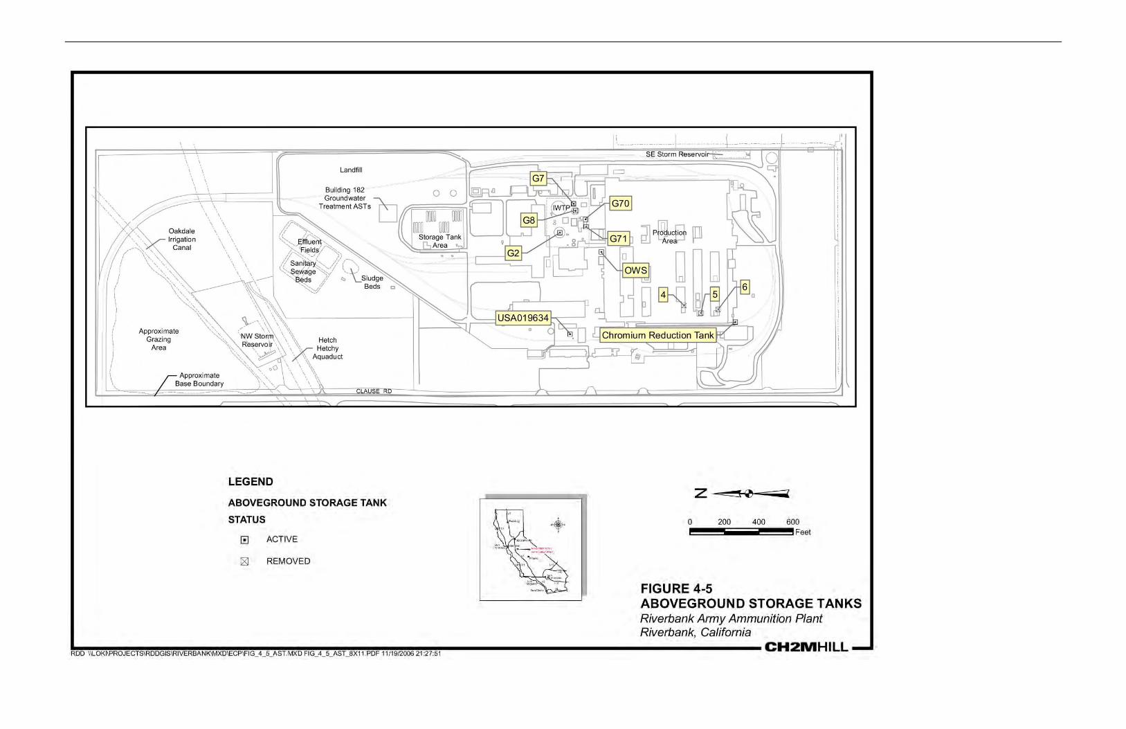
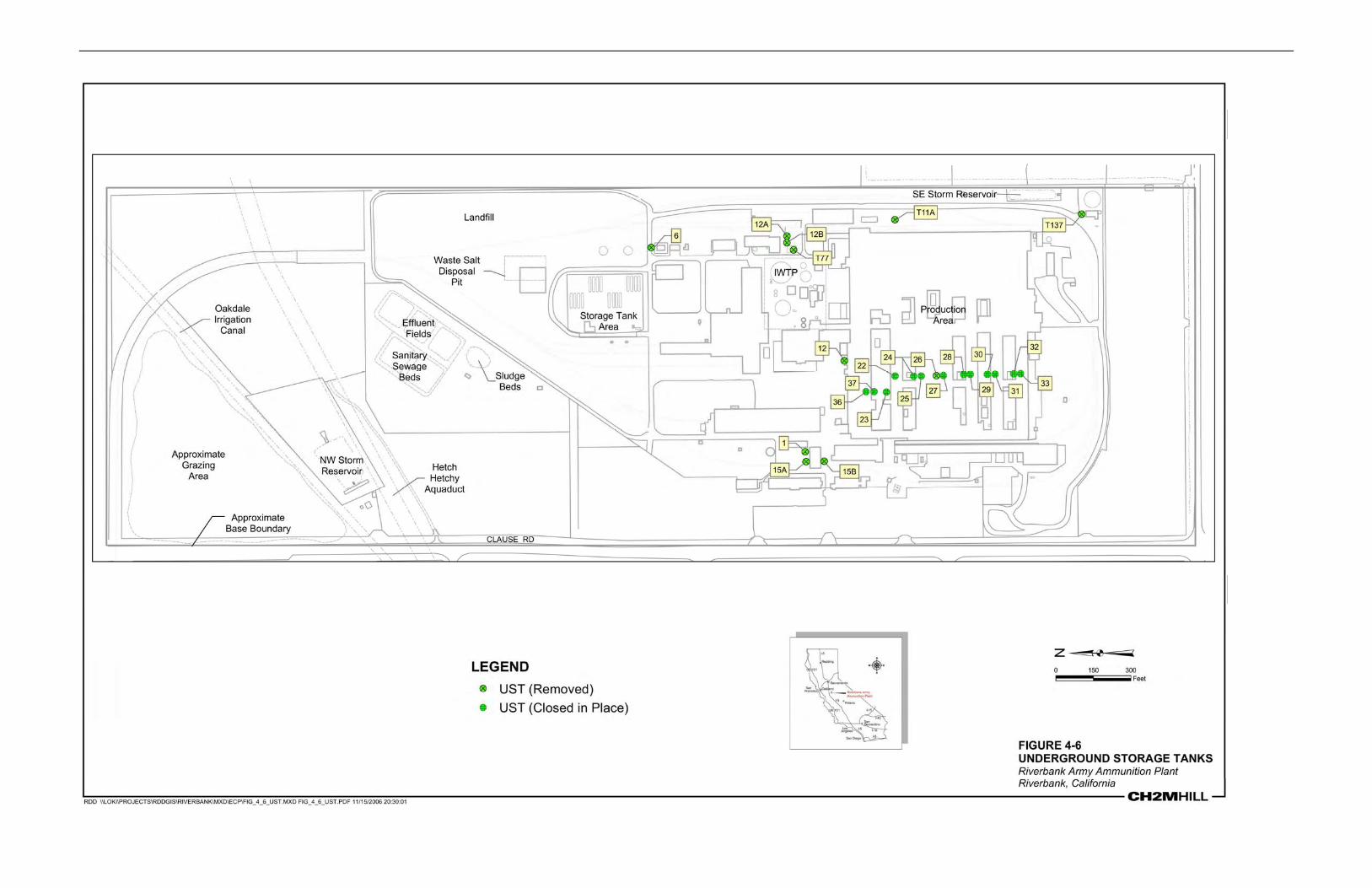
4.4.1. Underground Storage Tanks (USTs) and Above-Ground Storage Tanks (ASTs)
• Current UST/AST Sites - There is zero underground and one above-ground petroleum storage tank (UST/AST) on the Property. There is no evidence of a petroleum release from this site.
• Former UST/AST Sites - There were 7 USTs on the Property that have been
removed or closed in place. There were three ASTs on the Property. One diesel tank was removed (MascoTech, 1999a). Two vertical ASTs were used to store fuel oil from 1952 through 1958 until they were converted for the temporary storage of treated groundwater from the groundwater treatment system. There is no evidence of petroleum releases from these sites.

13
Additional information on USTs is contained in a U.S. Army Corps of Engineers (USACE) - Huntsville District study in September 1989 entitled "RBAAP Investigation and Evaluation of Underground Storage Tanks" (USACE, 1989). All USTs were closed at the facility under the oversight of the Regional Water Quality Control Board during 1994. The DTSC concurred with the position of the Army (as detailed in the original October 30, 1995, version of the RFI Phase 1 Work Plan) that no further action was required at the USTs under the RCRA program (CH2M HILL, 2002a).
A summary of the UST/AST petroleum product activities is provided in Table 3 – Notification of Petroleum Products Storage, Release, or Disposal (Enclosure 5).
4.4.2. Non-UST/AST Storage, Release, or Disposal of Petroleum Products There was non-UST/AST storage of petroleum products in excess of 55 gallons for one year or more on the property. The petroleum was used for the following types of activities: industrial operations and electrical equipment (transformers, substations). Petroleum product release or disposal in excess of 55 gallons occurred at the following buildings or areas: Buildings 3 East, 4 and 5 (which included Buildings 47, 48, and 49) and Building 10. No follow-up investigations have been completed. A summary of the non-UST/AST petroleum activities is provided in Table 3 – Notification of Petroleum Products Storage, Release, or Disposal (Enclosure 5).
4.5 Polychlorinated Biphenyls
Historically, electrical transformers located throughout RBAAP contained PCB dielectric fluid. Transformers with PCB concentrations less than 50 ppm are defined by the Toxic Substances Control Act (TSCA) as non-PCB transformers, transformers with PCB concentrations equal to or greater than 50 ppm but less than 500 ppm are defined as PCB-contaminated, and transformers with PCB concentrations equal to or greater than 500 ppm are defined as PCB transformers. Currently, five transformers are PCB-contaminated and five transformers are PCB transformers. This equipment is operational and properly labeled in accordance with federal and state regulations. A complete listing of PCB-containing transformers in excess of 50 ppm is presented in Enclosure 6, Table 4 (NI, 2006a).
Two sites were investigated under the RFI and removal actions completed to address PCB contamination in soils. These sites include AOC 8-B—Transformer Oil Storage Tanks and Distribution System and AOC 16—Substation 5 Transformer Pad. See Section 4.2 for information on these remedial actions.
Five locations were investigated for PCBs in the 2007 SI (CH2M HILL, 2008). These five locations include Building 11 (Paint and Oil Storage), Structure 95, Structure 97, Structure 101 (Substation Spare), and Structure 145 (Substation No. 17). All results were below TSCA requirements and no further action is required.
4.6 Asbestos-Containing Materials
There is asbestos-containing material (ACM) in the following buildings: __________ The ACM includes galbestos siding material for the buildings. The ACM does not currently pose a threat to human health or the environment because all friable asbestos that posed an

14
unacceptable risk to human health has been removed or encapsulated. The deed will include an asbestos warning and covenant (Enclosure 8). 4.7 Lead and Lead-Based Paint (LBP)
There are approximately 155 buildings at RBAAP. The majority of the buildings are presumed to contain LBP since they were constructed prior to 1978. The RBAAP has conducted limited LBP sampling surveys (CH2M HILL, 2006), but it is not comprehensive. The Property was not used for residential purposes, and the Grantee does not intend to use the Property for residential purposes in the future. The deed will include a lead-based paint warning and covenant (Enclosure 8).
4.8 Radioactive Material
According to Army records, RBAAP does not currently use or store any radioactive material. There is no record of Nuclear Regulatory Commission (NRC) licensed material ever having been used at RBAAP. The potential for the presence of radioactive material was investigated at three locations in the 2007 SI (CH2M HILL, 2008):
• Building 11 Paint & Oil All survey results met the acceptable surface contamination levels as established by the NRC. The SI recommended no further action at this site (CH2M HILL, 2008).
• Building 162 Autodin A.B. Terminal Building - Training Room: The radiological survey results for Building 162 were well below the screening levels. This survey confirms the absence of potential radioactive contamination (CH2M HILL, 2008).
• Building 174 Hazardous Waste Storage Area: The radiation survey results for Building 174 were well below the screening levels. The SI concluded that Building 174 did not require restrictions resulting from radiological activities (CH2M HILL, 2008.
4.9 Radon
A radon survey was conducted from September 1990 through November 1991 in Buildings 172, 9, 1, 13, 162, 14A, 120, 16A, and 9. Building 162 was the only building with radon above the EPA residential action level of 4 picocuries of radon per liter of air (pCi/L). Building 162 had a measured level of 5.2 pCi/L (MascoTech, 1999b).
4.10 Munitions and Explosives of Concern (MEC)
Based on a review of existing records and available information, there is no evidence that Munitions and Explosives of Concern (MEC) are present on the Property. The installation was only used for the manufacture of shell casings, which were then shipped to other locations for filling. An archives search, the Closed Transferring and Transferred Range/Site Inventory Report, and the Final Historical Records Review (USACE, 2006) detail that there is no record of munitions-related activities occurring on the Property. The term “MEC” means military munitions that may pose unique explosives safety risks, including: (A) unexploded ordnance (UXO), as defined in 10 U.S.C. §101(e)(5); (B) discarded military munitions (DMM), as defined

15
in 10 U.S.C. §2710(e)(2); or (C) munitions constituents (e.g., TNT, RDX), as defined in 10 U.S.C. §2710(e)(3), present in high enough concentrations to pose an explosive hazard.
4.11 Other Identified Concerns
There are no other hazardous conditions on the Property that present an unacceptable risk to human health and the environment.
5.0 ADJACENT PROPERTY CONDITIONS
Areas to the north and south of the Property are clean parcels at RBAAP that are being transferred under a Finding of Suitability for Transfer (FOST). These include Parcels 1, 1a, 2, 2a, and B which consist of a total of approximately 63.3 acres over the five parcels. These parcels are intended to be transferred for industrial/commercial reuse. Parcels 1, 1a, 2, and 2a will be transferred via public sale. Any transferee(s) purchasing the property will use the property for industrial/commercial use only and will comply with the land use restrictions. Parcel B will be transferred to the Local Reuse Authority via an Economic Development Conveyance. These transfers are consistent with the conditions set forth in the Riverbank Local Redevelopment Authority’s Base Reuse Plan dated October 30, 2008. A facility-wide groundwater-monitoring network is in place at RBAAP. The FOST parcels contain monitoring well clusters with historical detections of chromium and cyanide, but concentrations are below their respective MCLs. A groundwater use restriction will be placed on these parcels. All soil and groundwater investigations have been completed and no contaminants above regulatory limits have been identified. Therefore, the presence of these hazards on adjacent property does not present an unacceptable risk to human health and the environment.
In addition, on the east side of the E/P Ponds, there are four adjacent properties where encroachment onto the E/P Pond property has been documented by the U.S. Army. Provided below are descriptions of the encroachment issues associated with each of the adjacent properties:
• Parcel No. 062-008-010: At Parcel No. 062-008-010, a drainage piping was documented that drains onto the RBAAP E/P Pond property. The property owner has been informed of the requirement to remove the piping and repair the erosion caused by the piping (U. S. Army, 2006a).
• Parcel No. 062-008-005: At Parcel No. 062-008-005, the RBAAP E/P Pond boundary fence has been removed and replaced by a deck, retaining wall, ornamental plants, various building materials, and fill dirt. The owner has been informed of the requirement to remove all personal property, return the slope to its natural contour, and replace the chain link fence (U. S. Army, 2006b).
• Parcel No. 062-008-007: At Parcel No. 062-008-007, personal property and debris has been placed along the RBAAP E/P Pond fence, causing damage to the fence and failure of the slope. The owner has been informed of the requirement to remove all personal property from this area, return the slope to its natural contour, and repair the fence damage (U. S. Army, 2006c). This encroachment issued has been corrected (Army, 2007).
16
• Parcel No. 062-008-011: At Parcel No. 062-008-011, a stormwater drainpipe was
observed entering the RBAAP E/P Pond property, as well as oil stains at the foot of a retaining wall on the RBAAP E/P Pond property. The source of the oil stains is apparently from a waste oil tank located on Parcel No. 062-008-011. Preliminary soil samples on the RBAAP E/P Pond property indicated concentrations of 276,000 mg/kg (U. S. Army, 2006d).
6.0 ENVIRONMENTAL REMEDIATION AGREEMENTS
RBAAP was added to the NPL in February 1990. An FFA was signed by the Army, the EPA Region 9, the California DTSC, and the Central Valley Water Board, effective June 1990.
In addition, the site-wide ROD also applies to the Property (USAEC, 1994). The site-wide ROD contains two response actions: a groundwater response action and a landfill response action. Both response actions are currently implemented. Section 4.2 further outlines details on the landfill and groundwater contamination. The ROD also described two “post-ROD” potential actions that, although not part of the remedy, might need to be addressed based on future site conditions or findings (USAEC, 1994). These potential actions include:
• Investigation of the IWTP • Recharge of the A-zone
In June 2002, a CACA (Docket HWCA: P1-99/00-007) was signed between the Army and the DTSC. The CACA required that the Army perform an RFI on four AOCs and one SWMU:
• AOC 8B – Transformer Oil Storage Tanks and Distribution System • AOC 12 – Industrial Wastewater Collection System • AOC 14 – Zinc-Cyanide Collection System • AOC 16 – Substation 5/Building 11 • SWMU 16 – Pesticide Storage Area (Building 165)
The RFI recommended no further action for AOCs 8B, 14, 16, and SWMU 16 and deferred any additional actions at AOC 12 until base closure (CH2M HILL, 2005a). See Table 1 - Description of Property for additional information on these sites. In a letter from the DTSC, dated August 10, 2006, the DTSC confirmed that no further action was required at the SWMUs and AOCs with the exception of SWMU 1 (IWTP). As discussed in Section 4.2.3, additional characterization of the IWTP is precluded until permit closure due to the presence of existing system components. The deed will include a provision reserving the Army’s right to conduct remediation activities (Enclosure 8). 7.0 REGULATORY/PUBLIC COORDINATION AND COMMENTS
The EPA Region IX, the DTSC, and the public were notified of the initiation of this FOSET (Enclosure 9). The 30-day public review period was from _________, 2010 to _________, 2010. Regulatory/public comments received during the public comment period will be reviewed and incorporated, as appropriate. A copy of the regulatory/public comments and the Army Response will be included in Responsiveness Summary (Enclosure 10).

17
8.0 NATIONAL ENVIRONMENTAL POLICY ACT (NEPA) COMPLIANCE
The environmental impacts associated with the proposed transfer of the property have been analyzed in accordance with the National Environmental Policy Act (NEPA). The results of this analysis are documented in the Environmental Assessment for BRAC 05 Disposal and Reuse of the Riverbank Army Ammunition Plant, California (Marstel-Day, 2009) and the Finding of No Significant Impact, signed 13 July 2009. There were no encumbrances or conditions identified in the NEPA analysis as necessary to protect human health or the environment.
9.0 ENVIRONMENTAL PROTECTION PROVISIONS
In consideration of the intended use of the Property as commercial and industrial reuse, certain terms and conditions are required for the proposed transfer, including the prohibition on residential use. These terms and conditions are set forth in Enclosure 7 – CERCLA Deed Provisions and in Enclosure 8 –Environmental Protection Provisions and will be incorporated in the deed. These restrictions will be in effect until terminated, removed, or modified.
10.0 STATE LAND USE CONTROLS
With the transfer of this Property, SLUCs will be included to ensure the preservation of controls put in place to protect human health and the environment at those sites where contamination remains above levels allowable for unrestricted use. These sites include areas encompassing groundwater contamination resulting from the former IWTP operations, the landfill site, and industrial operation areas where contaminants in soil remain above levels allowing for unrestricted use. The sites will remain subject to regulation under RCRA and CERCLA as long as the contaminants present a threat to human health and the environment. The controls shall be implemented to achieve the following objectives:
• The continued compliance with all terms and conditions of the 1994 ROD under CERCLA and with the requirements of the existing RCRA Permit;
• Ensure that activities at a site or future uses remain in compliance with the restrictions outlined in the implementation plan for that site or environmental media;
• Prevent excavation and construction that would compromise the integrity of any protective structures, such as the landfill cap or pavement in the vicinity of the IWTP with the exception of Army and agency authorized activities;
• Prohibit the human consumption of groundwater on-site that exceeds Maximum Contaminant Levels (MCLs);
• Via Stanislaus County Department of Environmental Resources, provide landowners in the vicinity of the off-post groundwater contamination with annual notifications regarding the status of the cleanup efforts and advised use restrictions; and
• Ensure that routine maintenance activities required to ensure the integrity of the landfill cap and groundwater treatment/monitoring are performed, including inspections and maintenance to prevent damage or unauthorized modifications. The area defined as the E/P Ponds is currently used as a discharge basin for treated water from the GWTP and IWTP at RBAAP. The ponds receive water from RBAAP via a 3.4-mile underground pipe. Discharge to the ponds is conducted in accordance with the Regional Water Quality Control Board Waste Discharge Requirements Order No. 5-01-200 and RCRA Part B Permit SWMU 23 (Central Valley Water Board, 2001, DTSC, 2006).

18
Land use restrictions, notifications, covenants, conditions, and institutional controls will be implemented to ensure that the intended use of the Property is consistent with the requirements of CERCLA Section 120 (h)(3)(C) for the protection of human health and the environment. These LUCs are necessary for any ongoing or planned environmental restoration activities to protect human health or the environment after the early transfer. These provisions shall ensure any required future remedial investigations, response actions, and oversight activities will not be interrupted. The LUCs will remain in effect until terminated, removed, or modified with EPA and DTSC concurrence. Enclosure 2, Figures 8 and 9 show the land use and groundwater use restrictions, respectively, for RBAAP. Provisions describing implementation and enforcement of these restrictions are included in the SLUCs and described in the EPPs (Enclosure 8).
11.0 DEFERRED WARRANTY
When all response actions necessary to protect human health and the environment with respect to any hazardous substances remaining on the Property at the time of transfer have been completed, the Army shall execute and deliver to the purchaser of the Property (or its successor) an appropriate document containing a warranty that all response actions have been taken.

19
12.0 FINDING OF SUITABILITY FOR EARLY TRANSFER
Based on the above information, I conclude that all DOD requirements to reach a finding of suitability for early transfer of the Property to the RLRA for industrial and commercial reuse have been met. These uses of the Property are consistent with the protection of human health and the environment, subject to inclusion of the covenants and notifications in the EPP (Enclosure 8) into the deed for the Property. The CERCLA Deed Provisions (Enclosure 7) includes the CERCLA §120(h)(3)(C) covenant and access provisions.
With the covenants, conditions, and restrictions in the CERCLA Deed Provisions and the EPP, the Property can be transferred in its present condition for its intended purpose(s) without unacceptable risk to human health and the environment [CERCLA § 120(h)(3)(C)(i)(I)]. The deed for the Property will contain the following covenants and access clause:
• The covenant under CERCLA §120(h)(3)(A)(ii)(II) warranting that any additional
remedial action under CERCLA found to be necessary after the grant of the deferred warranty with respect to such hazardous substances remaining on the Property at the time of transfer shall be conducted by the United States.
• The clause as required by CERCLA §120(h)(3)(A)(iii) granting the United States access
to the Property in any case in which remedial action or corrective action is found to be necessary after the date of transfer.
As required under CERCLA § 120(h)(1) and DOD FOSET Guidance, a description of
remedial action taken, if any, and notification of hazardous substance activities and petroleum product activities shall be provided in the deed. See Table 1 - Description of Property, Table 2 - Notification of Hazardous Substance Storage, Release, or Disposal, Table 3 - Notification of Petroleum Product Storage, Release, or Disposal.
Addison D. Davis, IV
Deputy Assistant Secretary of the Army Environment, Safety, and Occupational Health
Enclosures Enclosure 1: Environmental Documentation Enclosure 2: Figures Enclosure 3: Table 1 – Environmental Condition of the Property Enclosure 4: Table 2 – Notification of Hazardous Substance Storage, Release, or Disposal Enclosure 5: Table 3 – Notification of Petroleum Product Storage, Release, or Disposal Enclosure 6: Table 4 – PCB and PCB-Contaminated Transformers Enclosure 7: CERCLA Notice, Covenant, Access Provisions and Deed Restrictions Enclosure 8: Environmental Protection Provisions Enclosure 9: Public Notice Enclosure 10: Responsiveness Summary
1
ENCLOSURE 1
ENVIRONMENTAL DOCUMENTATION
Ahtna Government Services Corporation (AGSC). 2006. Draft Second Five Year Review Report for Riverbank Army Ammunition Plant, City of Riverbank, Stanislaus County, California. July.
CH2M HILL. 2002a. RCRA Facility Investigation Current Conditions Report, Riverbank Army Ammunition Plant, Riverbank, California. October.
CH2M HILL 2002b. RCRA Facility Investigation, Phase 1 Work Plan. Prepared for the U.S. Army Corps of Engineers. Final. November.
CH2M HILL, 2003. RCRA Facility Investigation, Phase 1A Work Plan Addendum. Prepared for the US Army Corps of Engineers, Final. November.
CH2M HILL. 2005a. RCRA Facility Investigation Report. Riverbank Army Ammunition Plant, Riverbank, California. February 4.
CH2M HILL, 2006. Final U.S. Army BRAC 2005 Environmental Condition of Property Phase I Report, Riverbank Army Ammunition Plant, Riverbank, California. November.
CH2M HILL. 2008. Final Site Investigation Report. Riverbank Army Ammunition Plant, Riverbank, California. March.
Department of Toxic Substances (DTSC), 2006. No Further Action Letter (NFA) from the DTSC for RCRA Current Conditions Report, RBAAP, Stanislaus County. EPA ID No. CA210020759.
Envirodyne Engineers, Inc. (Envirodyne). 1986. Technical Plan for the Environmental Contamination Survey of the Riverbank Army Ammunition Plant, Riverbank, California, Phase II - Version 2. March.
Envirodyne Engineers, Inc. (Envirodyne). 1987. Remedial Investigation of the Riverbank Army Ammunition Plant, Riverbank, California. April.
Environmental Data Resources Inc (EDR). 2006a. The EDR Radius Map with GeoCheck, Riverbank AAP. June 12.
Environmental Data Resources Inc (EDR). 2006b. The EDR Aerial Photo Decade Package, Riverbank AAP. June 12.
Environmental Data Resources Inc (EDR). 2006c. The EDR Radius Map with GeoCheck, Riverbank E/P Ponds. June 13.
Environmental Data Resources Inc (EDR). 2006d. The EDR Aerial Photo Decade Package, Riverbank E/P Ponds. June 14.
Environmental Photographic Interpretation Center (EPIC). 1981. Installation Assessment, Riverbank Army Ammunition Plant, California. September.
Environmental Photographic Interpretation Center (EPIC). 1987. Site Analysis, Riverbank AAP, Riverbank, California. September.

ENVIRONMENTAL DOCUMENTATION
2
MacDonald and Mack Partnership. 1984. Historic Properties Report, Riverbank Army Ammunition Plant, Riverbank, California. August.
Marstel-Day, LLC. 2009. Final Environmental Assessment for BRAC 05 Disposal and Reuse of the Riverbank Army Ammunition Plant, California. Prepared for the U.S. Army Corps of Engineers: Mobile District. March.
MascoTech. 1999a. Final Tank Disposal for Tank T02. February 23.
MascoTech. 1999b. June 22, 1999 Meeting with Dr. Henry Crain (transmittal of radon monitoring data for Building 162). Riverbank Army Ammunition Plant, Riverbank, California. June 23.
NI Industries, Inc. (NI). 2003a. 2003 Pesticide Use Minimization Plan. Riverbank Army Ammunition Plant (RBAAP), Riverbank, California. January 3.
NI Industries, Inc. (NI). 2003b. Storm Water Pollution Prevention Plan (2003 SWPPP), Riverbank Army Ammunition Plant, Riverbank, California. March 3.
NI Industries, Inc. (NI). 2003d. Oil Spill Prevention Control and Countermeasure Plan (SPCCP), Riverbank Army Ammunition Plant, Riverbank, California. March 3.
NI Industries, Inc. (NI). 2004a. Asbestos Management Plan and Survey. Riverbank Army Ammunition Plant. March 30.
NI Industries, Inc. (NI). 2004b. Installation Pest Management Plan (IPMP) Submission for FY 2004. March 29.
NI Industries, Inc. (NI). 2004d. RCRA Part B Permit. Sections 8 and 13. November.
NI Industries, Inc. (NI). 2005a. 2004 Hazardous Waste Report (DTSC Annual Facility Report). February 22.
NI Industries, Inc. (NI). 2006a. Additional Documents Requested at the ECP Outbriefing Meeting. July 24.
NI Industries, Inc. (NI). 2006b. RBAAP Responses to ECP Comments Data Request. September 21.
Norris-Riverbank. 1998a. Environmental Baseline Survey, Phase I Environmental Assessment Report Tenant: Harbor Oil. Facility: Building 11. January 12.
Norris-Riverbank. 1998e. Environmental Baseline Survey Phase I Environmental Assessment Report. Facility: Buildings 3 East, 4, and 5. August 13.
Norris-Riverbank. 1998f. Environmental Baseline Survey Phase I Environmental Assessment Report. Facility: Building 10. September 22.
Norris-Riverbank. 1998h. Environmental Baseline Survey, Phase I Environmental Assessment Report. Facility: Building 14. November 11.
Norris-Riverbank. 1998i. Environmental Baseline Survey, Phase I Environmental Assessment Report. Facility: Building 130. November 23.
Norris-Riverbank. 1998j. Closure of Three Cyanide Tanks at Building 4, 5, and 6 Report. Riverbank Army Ammunition Plant, Riverbank, California. November 25.

ENVIRONMENTAL DOCUMENTATION
3
Norris-Riverbank. 1998n. Environmental Baseline Survey Phase I Environmental Assessment Report. Facility: Building 169. December 11.
Roy F. Weston, Inc. (Weston). 1991. Riverbank Army Ammunition Plant Remedial Investigation Report. Prepared for Commander, U.S. Army Toxic and Hazardous Materials Agency, Aberdeen Proving Ground, Maryland 21010-5401. July.
Roy F. Weston, Inc. (Weston). 1992a. Remedial Investigation (RI) Report – Riverbank Army Ammunition Plant. February.
Roy F. Weston, Inc. (Weston). 1992b. Riverbank Army Ammunition Plant Remedial Investigation Report Addendum. Prepared for Commander, U.S. Army Toxic and Hazardous Materials Agency, Aberdeen Proving Ground, Maryland 21010-5401. April.
Roy F. Weston, Inc. (Weston). 1993b. Feasibility Study (FS) Report – Riverbank Army Ammunition Plant. June.
SOTA Environmental Technologies, Inc. (SOTA). 1998. RCRA Facility Investigation Phase I Work Plan Revision No. 4, Riverbank Army Ammunition Plant, Riverbank, California. September.
Stanislaus County. 1995. Memo Re: UST Closure Report for Riverbank Army Ammunition Plant, 5300 Claus Road, Riverbank. Department of Environmental Resources, Hazardous Materials Division. April 28.
State of California. 1997. NPDES Industrial Storm Water Program – Permit. Riverbank Army Ammunition Plant, Riverbank, California. California Regional Water Quality Control Board, Central Valley Region. April 17.
State of California. 2001a. Draft MRP 5-01-200 (Amended) Permit Requirements, Riverbank Army Ammunition Depot, Riverbank, California. Regional Water Quality Control Board, Central Valley Region. June.
State of California. 2001b. Notice of Adoption of Updated Waste Discharge Requirements for United States Department of the Army and NI Industries – Waste Discharge Requirements Order. Riverbank Army Ammunitions Plant, Riverbank, California. California Regional Water Quality Control Board, Central Valley Region. August 1.
State of California. 2002. Corrective Action Consent Agreement – Health and Safety Code Section 23157. Riverbank Army Ammunition Plant, Riverbank, California. Environmental Protection Agency, Department of Toxic Substances Control. June 21.
State of California. 2005. Continuation of Expiring Hazardous Waste Storage and Treatment Permit, Riverbank Army Ammunition Plant (RBAAP), Stanislaus County. Department of Toxic Substances Control. Environmental Protection Agency ID No. CA210020759. July 29.
State of California. 2006. Hazardous Waste Facility Permit. California Environmental Protection Agency, Department of Toxic Substances Control. April 16.
Army. 1980. Installation Assessment of Riverbank Army Ammunition Plant. U.S. Army Toxic and Hazardous Materials Agency Report No. 144. January.
Army. 1996. Riverbank Army Ammunition Plant, RCRA Facilities Investigation – Phase 1 Work Plan Revision No. 2. Prepared by Norris Industries and Army staff at RBAAP. April.

ENVIRONMENTAL DOCUMENTATION
4
Army. 2001. First Five-Year Review Report for Riverbank Army Ammunition Plant, City of Riverbank, Stanislaus County, California. February 20.
Army. 2006a. Riverbank Army Ammunition Plant California; Encroachment on Army Property from Assessors Parcel No. 062-008-010. Management and Disposal Branch. February 13.
Army. 2006b. Riverbank Army Ammunition Plant California; Encroachment on Army Property from Assessors Parcel No. 062-008-005. Management and Disposal Branch. February 13.
Army. 2006c. Riverbank Army Ammunition Plant California; Encroachment on Army Property from Assessors Parcel No. 062-008-007. Management and Disposal Branch. February 13.
Army. 2006d. Riverbank Army Ammunition Plant California; Encroachment on Army Property from Assessors Parcel No. 062-008-011. Management and Disposal Branch. February 22.
Army. 2006e. Property Information Summary for Riverbank Army Ammunition Plant, California. http://www.hqda.army.mil/ACSIM/brac/PropertyInformationSummaries/ PropertyInformationSummaryRiverbankAAP.pdf. Base Realignment and Closure Division (BRACD).
Army. 2007. Letter to Mr. Javier Gonzalez from Jyuji D. Hewitt. July 2.
Army Environmental Center (USAEC). 1994. Record of Decision, Riverbank Army Ammunition Plant. March.
USAEC. 2005. ECP Workshop Meeting held 8/10/05, Riverbank Army Ammunition Plant. August.
USAEC. 2006a. U.S. Army BRAC 2005 Environmental Condition of Property Report, Riverbank Army Ammunition Plant, Riverbank, California. November 17.
USAEC. 2006b. Riverbank Army Ammunition Plant, California, Base Realignment and Closure Installation Action Plan, FY06. March.
U.S. Army Corps of Engineers (USACE). 1989. RBAAP Investigation and Evaluation of Underground Storage Tanks. Omaha District. September.
USACE. 2005. NEPA Action Plan. Developed by the USACE Mobile District Corps of Engineers, NEPA Support Team.
USACE. 2006. Final Historical Records Review, Riverbank Army Ammunition Plant. Sacramento District. January.
U.S. Army Material Command (USAMC). 2003. Closed Transferring and Transferred Range/Site Inventory Report, Riverbank AAP. March.
WESTON. 1991a. Riverbank Army Ammunition Plant Remedial Investigation Report. Prepared for U.S. Army Toxic and Hazardous Materials Agency, Aberdeen Proving Ground, Maryland 21010-5401. July.
WESTON.. 1991b. Riverbank Army Ammunition Plant Remedial Investigation Report Addendum. Prepared for U.S. Army Toxic and Hazardous Materials Agency, Aberdeen Proving Ground, Maryland 21010-5401. December.
WIRTH Environmental Services (WIRTH). 1988. An Archeological Overview and Management Plan for the Riverbank Army Ammunition Plant, Riverbank, California. February 10.

1
ENCLOSURE 2
FIGURES
Figure 1: Vicinity Map
Figure 2: Parcel Map
Figure 3: IRP Sites, SWMUs, and AOCs
Figure 4: Well Locations
Figure 5: Above Ground Storage Tanks
Figure 6: Under Ground Storage Tanks
Figure 7: Property Categorization Map
Figure 8: Land Use Restrictions
Figure 9: Groundwater Use Restrictions
Plate 1: RBAAP A/A’ Aquifer Zone Groundwater Elevation Contours with Third Quarter 2009 Chromium and Cyanide Concentrations
Plate 2: RBAAP B Aquifer Zone Groundwater Elevation Contours with Third Quarter 2009 Chromium and Cyanide Concentrations
Plate 3: RBAAP C Aquifer Zone Groundwater Elevation Contours with Third Quarter 2009 Chromium and Cyanide Concentrations
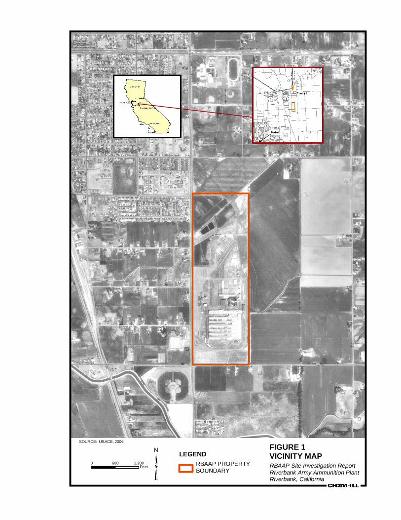
FIGURE 1
VICINITY MAP
RBAAP Site Investigation ReportRiverbank Army Ammunition PlantRiverbank, California³
SOURCE: USACE, 2006
0 600 1,200Feet
LEGEND
RBAAP PROPERTY
BOUNDARY

1. PURPOSE
ES082006004SCO/BRAC_RB_ECP_FINAL.DOC/062720011 5
FIGURE 2PARCEL MAP
Parcel B
Parcel 2a
Parcel 2Parcel 1
Parcel 1a
Note: Parcel boundaries shown are approximate.

4. ENVIRONMENTAL CONDITIONS
ES082006004SCO/BRAC_RB_ECP_FINAL.DOC/062720011 4-7
FIGURE 3

Legend: Approximate Boundary of the RBAAP General Production and Operation Areas Subject to Land Use Restrictions Buildings FIGURE 8
RBAAP General Production and Operation Areas Subject to Land Use Restrictions

FIGURES
Legend:
Approximate Facility Boundary defining Area of On-Site Groundwater Use Restriction.
Building
FIGURE 9Area of On-Site Groundwater Use Restrictions RBAAP

!
!
!!
!!
!
!
!
!
!
!
! !
!
!
!
!
!!
! !
!
!
!
!
!
! ! ! !
! !
! !
!
! !!
!
!
!
!
!
!
!
!
MW 9 A-NSDNSD
MW 18 A-NSINSI
MW 56 A-NSSNSS
MW 57 A-NSSNSS
MW 45 A-NSSNSS
MW 20 A-NSINSI
MW 16 A-NSINSI
MW 15 A-NSINSI
MW 60 A-NSSNSS
MW 61 A-NSSNSS
MW 55 A-NSSNSS
MW 5 A'73.61NDND
MW 102 A'-NSDNSD
MW 34 A'71.9214ND
MW 14 A'73.06NDND
MW 65 A'73.6353ND
MW 117 A'74.4133ND
MW 119 A'75.16ND11
MW 69 A '71.6737ND
MW 73 A '73.2713ND
MW 74 A '73.00NDND
MW 46 A74.52NSINSI
MW 49 A74.90NSINSI
MW 50 A77.49NSINSI
MW 51 A75.01NSINSI
MW 54 A71.19NSINSI
MW 71 A '72.31ND38
MW 62 A'72.84ND100
MW 111 A'71.24NDND
MW 109 A'70.941622
PW 116 A'71.654947
PW 115 A'71.26NDND
MW 104 A'70.38NDND
MW 105 A'71.37NDND
MW 68 A'73.77NSSNSS
MW 66 A'72.80NSSNSS
MW 61 A'73.34NSSNSS
MW 41 A'71.71NSSNSS
MW 120 A'74.10NDND
MW 107 A'71.41NSSNSS
EW 113 A'71.43NSPNSP
EW 63 A'70.19ND360
MW 17 A'73.6812 (13)15 (ND)
MW 45 A '72.32NDND
MW 47 A74.89NSSNSS
MW 52 A74.72NSINSI
MW 110 A'71.23NSSNSS
71
72
73
7475
77 CLAUS RD
CLAR
IBEL
RD
DAVIS
AVE
MINN
IEAR
AVE
VAN
DUSE
N AV
E
PRIN
CE A
NDRE
W D
R
SIERRA VISTA DR
MADE
RA C
TPR
INCE
GEO
RGE
LN
INCL
INE
WY
PRINCE PHILIP WY
PRINCE NORMAN WY
PRINCE EDWARD LN
CELESTINO CT
BADG
ER PA
SS D
R
Highway 1
Highway 68
Reservation RoadImjin Road8th Street
Parker Flats Road
Blanco Road
Eucalyptus Road (West)Broadway Road
Highway 218
Coe Avenue
3rd Avenue
Barloy Canyon Road
Gigling Road
12th Street
Fremont Street
Del Monte Boulevard Eucalyptus Road (East)
Laureles Grade
Abrams Road Watkins Gate Road
General Jim Moore Boulevard
Inter-Garrison Road
Monterey Road
Barloy Canyon Road
Watkins Gate Road
§̈¦
80
§̈¦
40
§̈¦
15
§̈¦
10
§̈¦
5
§̈¦
84
§̈¦
70
California
Nevada
Utah
Arizona
Oregon
Idaho
Groundwater elevation data from active extraction wells is not used to determine groundwater elevation contour locations.Color Air Photo Source: NAIP 2006, 1 Meter
50
Groundwater Elevation Contour
Extraction Well
Monitoring Well
Groundwater ElevationNo Measurement Recorded
Chromium Isoconcentration (µg/L)
Not Detected
Chromium Isoconcentration Line
Cyanide Concentration (µg/L)
Not Sampled
Not DetectedNot Sampled
72
76.58
NDNS
76.58
NDNS
76NR
!(
!(
0 400 800Feet
/
Plate 1: RBAAP A/A' Aquifer Zone Groundwater Elevation Contours with Third Quarter 2009Chromium and Cyanide Concentrations
Riverbank Army Ammunition Plant
³
Predominate GW Gradient
200 Cyanide Isoconcentration Line
50 (Historical) Chromium Isoconcentration Line
200 (Inferred) Cyanide Isoconcentration Line
TEAEnvironmentalConsulting

!
!
!
!
!
!
!!
!
!!
!
!
!
!
!
!
!
!
!
!
!
!
!
!
!
MW 52 B-12NSS
MW 5 B73.64NDND
MW 109 B-NSPNSP
MW 104 B-47ND
EW 54 B71.98NDND
MW 45 B72.31ND22
EW 72 B70.52ND33MW 34 B
71.96NDND MW 66 B
72.64NDNSS
MW 102 B71.21NDND
MW 111 B71.311357MW 105 B
71.3011ND
MW 112 B70.59NDND
MW 68 B73.66NSSNSS
MW 17 B73.55NSSNSS
MW 14 B73.44NSSNSS
MW 62 B72.78NSSNSS
MW 61 B73.29NSSNSS
MW 41 B71.67NSSNSS
MW 118 B74.37100ND
PW 116 B71.61NSSNSS
MW 107 B71.44NSSNSS
EW 113 B71.39ND11
MW 110 B66.21NSSNSS
EW 114 B70.7870ND
PW 115 B71.1921 (21)18 (13)
71
72
73
74
66
CLAUS RD
CLAR
IBEL
RD
DAVIS
AVE
MINN
IEAR
AVE
VAN
DUSE
N AV
E
PRIN
CE A
NDRE
W D
R
MADE
RA C
TPR
INCE
GEO
RGE
LN
PRINCE PHILIP WY
CELESTINO CT
INCL
INE
WY
PRINCE NORMAN WY
PRINCE EDWARD LN
BADG
ER PA
SS D
R
Highway 1
Highway 68
Reservation RoadImjin Road8th Street
Parker Flats Road
Blanco Road
Eucalyptus Road (West)Broadway RoadHighway 218
Coe Avenue
3rd Avenue
Barloy Canyon Road
Gigling Road
12th Street
Fremont Street
Del Monte Boulevard Eucalyptus Road (East)
Laureles Grade
Abrams Road Watkins Gate Road
General Jim Moore Boulevard
Inter-Garrison Road
Monterey Road
Barloy Canyon RoadWatkins Gate Road
§̈¦
80
§̈¦
40
§̈¦
15
§̈¦
10
§̈¦
5
§̈¦
84
§̈¦
70
California
Nevada
Utah
Arizona
Oregon
Idaho
50
200
Groundwater Elevation Contour
Extraction Well
Monitoring Well
Groundwater ElevationNo Measurement Recorded
Chromium Isoconcentration (µg/L)
Not Detected
Chromium Isoconcentration Line
Cyanide Isoconcentration LineCyanide Concentration (µg/L)
Not Sampled
Not DetectedNot Sampled
80
76.58
NDNS
76.58
NDNS
76NR
!(
!(
0 400 800Feet
/
Plate 2: RBAAP B Aquifer Zone Groundwater Elevation Contours with Third Quarter 2009Chromium and Cyanide Concentrations
Riverbank Army Ammunition Plant
³
Predominate GW Gradient
50 (Historical) Chromium Isoconcentration Line
TEAEnvironmentalConsulting
Groundwater elevation data from active extraction wells is not used to determine groundwater elevation contour locations.Color Air Photo Source: NAIP 2006, 1 Meter

!
!
!
!
!
!
!!
!
!
!
!
!
!
!
!
!
!
!
!
!
!
!
MW 47 C71.87NDND
MW 52 C71.461116
MW 5 C73.53NSSNSS
MW 102 C70.93NDND
MW 111 C71.36NDND
MW 109 C70.89NDND
MW 107 C71.36NDND
PW 115 C71.23NDNDMW 105 C
71.3539ND
MW 112 C70.56NDND
MW 104 C70.638321
MW 45 C72.30NSSNSS
MW 54 C71.59NSSNSS
MW 14 C73.12NSSNSS
MW 68 C73.66NSSNSS
MW 17 C73.52NSSNSS
MW 62 C72.63NSSNSS
MW 34 C71.88NSSNSS
MW 61 C73.19NSSNSS
MW 66 C72.71NSSNSS
EW 113 C71.35NSSNSS
EW 114 C70.8824ND
PW 116 C71.56NSSNSS
71
72
73
79
CLAUS RD
CLAR
IBEL
RD
DAVIS
AVE
MINN
IEAR
AVE
VAN
DUSE
N AV
E
PRIN
CE A
NDRE
W D
R
MADE
RA C
TPR
INCE
GEO
RGE
LN
PRINCE PHILIP WY
CELESTINO CT
INCL
INE
WY
PRINCE NORMAN WY
PRINCE EDWARD LN
BADG
ER PA
SS D
R
Highway 1
Highway 68
Reservation RoadImjin Road
8th Street
Parker Flats Road
Blanco Road
Eucalyptus Road (West)Broadway Road
Highway 218
Coe Avenue
3rd Avenue
Barloy Canyon Road
Gigling Road
12th Street
Fremont Street
Del Monte Boulevard Eucalyptus Road (East)
Laureles Grade
Abrams Road Watkins Gate Road
General Jim Moore Boulevard
Inter-Garrison Road
Monterey Road
Barloy Canyon Road
Watkins Gate Road
§̈¦
80
§̈¦
40
§̈¦
15
§̈¦
10
§̈¦
5
§̈¦
84
§̈¦
70
California
Nevada
Utah
Arizona
Oregon
Idaho
50
200
Groundwater Elevation Contour
Extraction Well
Monitoring Well
Groundwater ElevationNo Measurement Recorded
Chromium Isoconcentration (µg/L)
Not Detected
Chromium Isoconcentration Line
Cyanide Isoconcentration LineCyanide Concentration (µg/L)
Not Sampled
Not DetectedNot Sampled
80
76.58
NDNS
76.58
NDNS
76NR
!(
!(
0 400 800Feet
/
Plate 3: RBAAP C Aquifer Zone Groundwater Elevation Contours with Third Quarter 2009Chromium and Cyanide Concentrations
Predominate GW Gradient
50 (Historical) Chromium Isoconcentration Line
Riverbank Army Ammunition Plant
³TEAEnvironmentalConsulting
Groundwater elevation data from active extraction wells is not used to determine groundwater elevation contour locations.Color Air Photo Source: NAIP 2006, 1 Meter

Page 1 of 28
ENCLOSURE 3
TABLE 1 – ENVIRONMENTAL CONDITION OF THE PROPERTY
Property Description
ECP Study Section(s)
ECP Category
Remedial Actions
Landfill (RBAAP-01/SWMUs 10 and 11)
1, 22, 23 5 RBAAP-01 is approximately 4.5 acres and is located in the northern section of the main plant near the eastern boundary. The landfill was the site of surface and trench disposal and burning from 1942 to 1966. The site was addressed under the 1994 ROD. Remedial activities at the landfill were completed in October 1995. The final landfill cover consisted of a two-foot-thick vegetative cover layer, a one-quarter-inch-thick geosynthetic liner, and a two-foot-thick foundation layer. Long-term maintenance is required until 2015.
Waste Salt Disposal Pit (RBAAP-02/SWMU 18)
2 3 This site is located adjacent to the former landfill. The waste salt pond was constructed for use as an evaporation basin for wash water from the nitrate molten salt annealing process. Completed in 1969, it was never used for this purpose because anticipated orders were never received. According to plant officials, the waste salt pond was not used for any disposal operations. Sampling of the pond was not conducted based on this information. The site-wide ROD documented that no further action is required at this site (USAEC, 1994).
This site is Category 3 based on groundwater contamination currently present but below Maximum Contaminant Levels (MCLs).
Groundwater Contamination (RBAAP-03)
3 5 The IRP Site RBAAP-03 represents chromium and cyanide groundwater contamination resulting from leakage associated with the original IWTP. The original storage and equalization tanks used for the IWTP were made of redwood. From 1973 to 1980, the IWTP was upgraded and the redwood tanks were replaced with concrete tanks. The upgraded IWTP, identified as SWMU 1, continues to operate under a RCRA Part B Permit 05-SAC-06.
In 1985, the Army installed an interim groundwater treatment system (GWTS) and provided bottled drinking water to those affected residents followed by the

TABLE 1 – ENVIRONMENTAL CONDITION OF THE PROPERTY (CONTINUED)
Page 2 of 28
Property Description
ECP Study Section(s)
ECP Category
Remedial Actions
extension of the Riverbank city water system to all potentially affected residents. In March 1994, the EPA Region 9, the DTSC, the Central Valley Water Board, and the Army signed the ROD. The ROD required expansion of the interim GWTS. The expanded system began operation in 1997. The cleanup goal for chromium is 50 μg/L and 200 μg/L for cyanide.
Groundwater monitoring consists of four sampling events per year; two quarterly, one semiannual and one annual which include specific sets of wells completed in the various A', A, B, C and D portions of the aquifer. The locations of the monitoring wells is shown in Enclosure 2, Figure 4. The results of the groundwater sampling from the third quarter of 2009 are shown on Plates 1, 2, and 3 (AHTNA, 2009).
The Army believes the current remedial action captures all contaminated groundwater and is protective of human health and the environment. There is chromium contamination exceeding the maximum contaminant level (MCL) in the furthest down-gradient monitoring well (MW104C). However, the furthest down-gradient extraction well (EW104B) is currently in operation and is maintaining capture of this area of contamination. Unpublished Fourth Quarter 2009 analytical data indicates this by showing a decline in chromium concentrations in the area.
The Army completed the first Five Year Review in February 2001 (Army, 2001) and the second Five Year Review in September 2006 (AHTNA, 2006). Both Five Year Reviews concluded that the groundwater remedy was functioning as intended and was protective of human health and the environment.
In September 2007, the Army initiated, with regulatory approval, a one-year shutdown of the groundwater pump and treatment system to study rebound effects, and an in situ pilot test of ferrous iron and carbon to determine if this could result in an alternative treatment of residual hexavalent chromium in the groundwater. As part of this effort, the Army installed four new monitoring wells

TABLE 1 – ENVIRONMENTAL CONDITION OF THE PROPERTY (CONTINUED)
Page 3 of 28
Property Description
ECP Study Section(s)
ECP Category
Remedial Actions
(117, 118, 119, and 120) to be included in the monthly monitoring of rebound effects. The localized contamination and plume stability indicated by the results of the Rebound Study support localized in situ treatment for the remaining areas of chromium contamination. The results of the in situ pilot test demonstrated that reductant injections rapidly reduced dissolved chromium concentrations by precipitating chromium. The Army is currently preparing an Explanation of Significant Differences (ESD) to conduct in-situ treatment to address chromium. The Army is also working on the development of an ESD to address institutional controls. Remedial actions at RBAAP-03 will continue until remedial goals have been reached.
Building 13 Chromium Pretreatment System (RBAAP-05/ SWMU 5)
5 3 This site is located in the southern end of Building 13. The chromium pretreatment system was installed in 1978 as part of the upgrades to the IWTP. No direct sampling was conducted around this system because it is an operating facility. However, the groundwater investigation concluded that the major source of chromium contamination was the leaking tanks of the IWTP prior to the system upgrade. The site-wide ROD documented that no further action is required at this site (USAEC, 1994).
This site is NFA based on the investigation results, but Category 3 based on groundwater contamination currently present but below Maximum Contaminant Levels (MCLs).
IWTP Sulfuric Acid Spill (RBAAP-06/ AOC 6)
6, 43 7 In 1956, a sulfuric acid spill occurred at the Sulfuric Acid Feed System, adjacent to the redwood equalization tanks. This site is north of Building 173. The sulfuric acid spill was a 500-gallon release from a pipe break that was reportedly neutralized immediately with lime.
Groundwater monitoring for sulfate was conducted. Historically, sulfate concentrations in groundwater in the IWTP area were present at levels slightly above the secondary MCL of 250 milligrams per liter (mg/L). Monitoring well NI-20, downgradient of the spill area, identified sulfate at concentrations of 450

TABLE 1 – ENVIRONMENTAL CONDITION OF THE PROPERTY (CONTINUED)
Page 4 of 28
Property Description
ECP Study Section(s)
ECP Category
Remedial Actions
mg/L during Exploratory Phase 1B sampling in 1985. The groundwater table receded thereafter, and NI-20 could no longer be sampled. In 1990, the sulfate concentration was detected at 23.3 mg/L in the shallow groundwater zone A’ and is no longer considered a groundwater concern in the IWTP area. It is unknown if the slightly elevated sulfate concentration found during the Exploratory Phase 1B was the result of the 1956 sulfuric acid spill. The groundwater extraction system will capture any sulfate contamination in groundwater and the effluent from the GWTP is monitored for sulfate under the NPDES permit.
In a letter dated July 27, 1998, the DTSC concurred with the position of the Army (as detailed in the February 1998 Revision 4 of the RFI Phase 1 Work Plan) that no further action was required for this AOC (CH2M HILL, 2002a).
This site is NFA based on the investigation results, but Category 7 based on its location within the SMWU 1 boundary.
Building 13 Phosphoric Acid Spill (RBAAP-07/AOC 7)
7, 44 3 In 1978, a phosphoric acid spill occurred in the Phosphate Coating Area, upstairs in the southern end of Building 13. The phosphoric acid spill resulted in approximately 100 gallons of phosphoric acid being released onto the second story concrete floor. The acid was washed down the industrial sewer drain, did not leave the building, and did not contact any soil or groundwater. Because the spill was contained inside the building, and then in the sewer system, there is no further action required in this area. In a letter dated June 5, 1996, the DTSC concurred with the position of the Army (as detailed in the April 15, 1996 Revision 2 of the RFI Phase 1 Work Plan) that no further action was required for this AOC (CH2M HILL, 2002a).
This site is Category 3 based on groundwater contamination currently present but below Maximum Contaminant Levels (MCLs).
Southeast Storm Reservoir (RBAAP-
8 4 The Southeast Storm Reservoir is 230-feet long and 44 feet wide with a total storage capacity of 430,000 gallons. The Southeast Storm Reservoir originally was constructed in 1954 and has been in use ever since. The Southeast Storm

TABLE 1 – ENVIRONMENTAL CONDITION OF THE PROPERTY (CONTINUED)
Page 5 of 28
Property Description
ECP Study Section(s)
ECP Category
Remedial Actions
08/SWMU 21/AOC 16)
Reservoir collects stormwater from the southeast portion of the site and then pumps the water to the Northwest Storm Reservoir for ultimate discharge offsite. Stormwater runoff is the only known source to the reservoir. Investigations during the RI did not indicate contaminants of concern in this area. Based on the RI’s findings, the ROD (USAEC, 1994) concluded that remedial action was not warranted in this area.
However, a sample was subsequently collected in the reservoir for PCB analysis (associated with the investigation of AOC 16 (Substation 5)). PCBs were detected at 4.5 mg/kg and additional sampling was conducted as part of the RFI at AOC 16. Soil removal was conducted as part of the removal action at AOC 16. The Final RFI Report recommended no further action for this SWMU (CH2M HIL, 2005a). The DTSC concurred by approving the Final RFI Report.
Percolation/Evaporation Ponds (E/P Ponds) (RBAAP-11/ SWMU 23)
11, 35 4 The E/P Ponds occupy 27 acres on the banks of the Stanislaus River approximately 1.5 miles north of the main installation. The E/P Ponds were constructed in 1952 for the disposal of treated effluent generated at the RBAAP. Based on the RI findings, a removal action was completed in 1993 to address zinc-contaminated soil. The ROD documented this removal action and concluded that no further action was necessary at the ponds (USAEC, 1994). RBAAP continues to use the E/P Ponds for discharge of treated water. This discharge is regulated under Waste Discharge Requirements (WDRs) issued by the Central Valley Water Board. The WDRs require ongoing groundwater monitoring at the E/P Ponds.
Industrial Wastewater Treatment Plant (SWMU 1)
13 7 The IWTP is a treatment facility for industrial wastewater from electroplating, cleaning, and metal finishing processes. Treated effluent water is discharged to the facility E/P Ponds. The IWTP was originally built in 1951. Since 1972, numerous upgrades and improvements have been implemented at the IWTP. The redwood equalization tanks were replaced with a concrete equalization basin in 1980. The redwood tanks were the source of the chromium and cyanide contamination in the IWTP area. The entire IWTP area is now covered with

TABLE 1 – ENVIRONMENTAL CONDITION OF THE PROPERTY (CONTINUED)
Page 6 of 28
Property Description
ECP Study Section(s)
ECP Category
Remedial Actions
concrete or asphalt. A series of concrete drainage trenches captures spills and overflows and drains to the former influent sump, which is currently used as a secondary containment sump for the IWTP.
The Phase I RI, conducted between January 1987 and November 1998, included two soil borings at the IWTP. Samples were analyzed for total and hexavalent chromium, total and free cyanide, and 1,1-DCE. Soil borings SB-14 and SB-15 were advanced to a depth of 50 feet bgs in the area where the former redwood tanks were located. At SB-14, total chromium was detected at a concentration of 23.5 mg/kg at 40 feet bgs, and 18.0 mg/kg at 50 feet bgs. At SB-15, total chromium was detected at a concentration of 22.15 mg/kg at 40 feet bgs, and 55.83 mg/kg at 50 feet bgs (Weston, 1991).
The IWTP remains an active unit. The DTSC (in a letter dated July 27, 1998) states that additional characterization of soil at the IWTP is precluded by existing equipment. Additional characterization of the IWTP is precluded until permit closure due to the presence of existing system components. The groundwater under the IWTP is being addressed under the site RBAAP-03.
Hazardous Waste Storage Area (Drum Storage Facility) (SWMU 2)
14 5 The Hazardous Waste Storage Area for the 55-gallon containers is located in Building 174, which is 100 feet long and 50 feet wide. The capacity of the facility is 300 drums and consists of a concrete slab with three 400-gallon sumps and 6-inch curbing for secondary containment. No known spills have been recorded in this facility. The Hazardous Waste Storage Area is regulated under the RCRA Part B permit. RCRA closure is required for this unit. The DTSC concurred with the position of the Army (as detailed in the original October 30, 1995 version of the RFI Phase 1 Work Plan) that no further action was required for this unit (CH2M HILL, 2002a).
This site is NFA based on the investigation results, but is ECP Category 5 based on groundwater contamination currently exceeding MCLs.
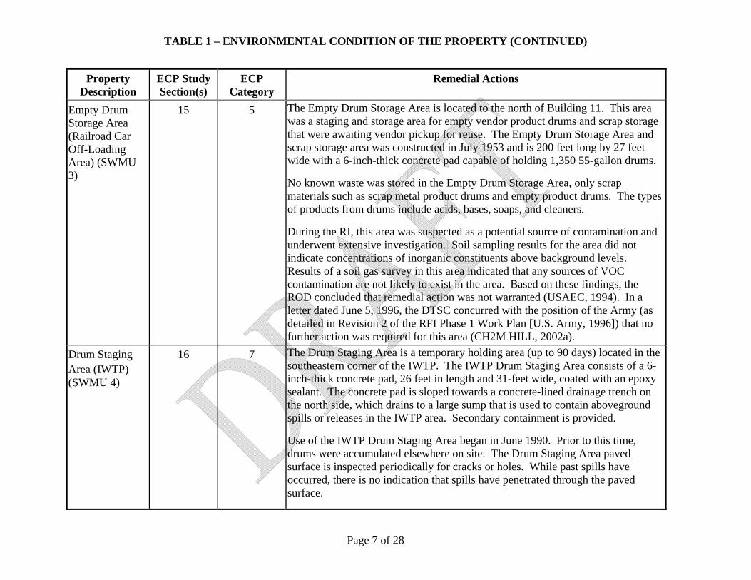
TABLE 1 – ENVIRONMENTAL CONDITION OF THE PROPERTY (CONTINUED)
Page 7 of 28
Property Description
ECP Study Section(s)
ECP Category
Remedial Actions
Empty Drum Storage Area (Railroad Car Off-Loading Area) (SWMU 3)
15 5 The Empty Drum Storage Area is located to the north of Building 11. This area was a staging and storage area for empty vendor product drums and scrap storage that were awaiting vendor pickup for reuse. The Empty Drum Storage Area and scrap storage area was constructed in July 1953 and is 200 feet long by 27 feet wide with a 6-inch-thick concrete pad capable of holding 1,350 55-gallon drums.
No known waste was stored in the Empty Drum Storage Area, only scrap materials such as scrap metal product drums and empty product drums. The types of products from drums include acids, bases, soaps, and cleaners.
During the RI, this area was suspected as a potential source of contamination and underwent extensive investigation. Soil sampling results for the area did not indicate concentrations of inorganic constituents above background levels. Results of a soil gas survey in this area indicated that any sources of VOC contamination are not likely to exist in the area. Based on these findings, the ROD concluded that remedial action was not warranted (USAEC, 1994). In a letter dated June 5, 1996, the DTSC concurred with the position of the Army (as detailed in Revision 2 of the RFI Phase 1 Work Plan [U.S. Army, 1996]) that no further action was required for this area (CH2M HILL, 2002a).
Drum Staging Area (IWTP) (SWMU 4)
16 7 The Drum Staging Area is a temporary holding area (up to 90 days) located in the southeastern corner of the IWTP. The IWTP Drum Staging Area consists of a 6-inch-thick concrete pad, 26 feet in length and 31-feet wide, coated with an epoxy sealant. The concrete pad is sloped towards a concrete-lined drainage trench on the north side, which drains to a large sump that is used to contain aboveground spills or releases in the IWTP area. Secondary containment is provided.
Use of the IWTP Drum Staging Area began in June 1990. Prior to this time, drums were accumulated elsewhere on site. The Drum Staging Area paved surface is inspected periodically for cracks or holes. While past spills have occurred, there is no indication that spills have penetrated through the paved surface.

TABLE 1 – ENVIRONMENTAL CONDITION OF THE PROPERTY (CONTINUED)
Page 8 of 28
Property Description
ECP Study Section(s)
ECP Category
Remedial Actions
Soil samples indicated no detections above background. The Army, in Revision 4 of the RFI Phase 1 Work Plan dated February 1998, presented justification supporting a finding that no further action is recommended for this unit at this time (SOTA, 1998). The DTSC (in a letter dated July 27, 1998) concurred with this recommendation (CH2M HILL, 2002a).
Chromium Reduction Units (Building 13) (SWMU 5)
17 3 The chromium reduction unit in Building 13 was installed in 1978. The unit consists of a 1,200-gallon stainless steel tank. Sodium metabisulfide was added to chromic acid solution to reduce hexavalent chromium to a trivalent state in a batch process. The wastewater was then piped to the IWTP for further treatment. No evidence was found that any releases occurred from this unit. DTSC concurred with the position of the Army, as detailed in the original version of the RFI Phase 1 Work Plan, that no further action was required at the Chromium Reduction Units in Buildings 13 and 1 (CH2M HILL, 2002a).
This site is Category 3 based on groundwater contamination currently present but below Maximum Contaminant Levels (MCLs).
Chromium Reduction Units (Building 1) (SWMU 6)
18 5 The chromium reduction unit in Building 1 was installed in 1978. The unit consists of a 1,200-gallon stainless steel tank. Sodium metabisulfide was added to chromic acid solution to reduce hexavalent chromium to a trivalent state in a batch process. The wastewater was then piped to the IWTP for further treatment. No evidence was found that any releases occurred from these units. DTSC concurred with the position of the Army, as detailed in the original version of the RFI Phase 1 Work Plan, that no further action was required at the Chromium Reduction Units in Buildings 13 and 1 (CH2M HILL, 2002a).
This site is NFA based on the investigation results, but is ECP Category 5 based on groundwater contamination currently exceeding MCLs.
Coolant Recovery Unit (IWTP) (Hyde Ultrafiltration
19 7 The coolant recovery unit recovers usable coolant from waste machine coolant oil by separating the waste mixture into usable coolant (soluble oil), water, and thermally degraded coolant. The coolant recovery unit is located on the south side of the IWTP area, immediately south of Building 43. The tanks and recovery unit

TABLE 1 – ENVIRONMENTAL CONDITION OF THE PROPERTY (CONTINUED)
Page 9 of 28
Property Description
ECP Study Section(s)
ECP Category
Remedial Actions
Unit) (SWMU 7) are located on a concrete slab surrounded by a 6-inch concrete containment curb with a small sump and pump that pumps spilled fluid back into a holding tank. No releases from the coolant recovery unit have been documented. There is no evidence of spills outside the containment area and no cracks or holes are apparent in the containment area or sump.
In RFI Phase 1, the small collection sump was steam cleaned and visually inspected for cracks or holes in the concrete. No cracks or holes were discovered and the unit was recommended for closure with no further action. In a letter from the DTSC, dated August 10, 2006, the DTSC confirmed that no further action was required for SWMU 7 (DTSC, 2006).
This site is NFA based on the investigation results, but Category 7 based on its location within the SMWU 1 boundary.
Waste Oil Accumulation Unit (Waste Oil Storage Tank) (SWMU 8)
20 7 The waste oil tank, installed in 1994, is a 6,000-gallon, UL142 API650 approved, steel AST located on a 6-inch-thick reinforced concrete slab. The tank is visible on all sides and the bottom. The secondary containment area, coated with an epoxy sealant coating, is approximately 30 feet by 20 feet by 3 feet. The 6-inch reinforced concrete containment area is in excellent condition with no observed cracks or holes. The epoxy sealant coating is intact and in good condition (CH2M HILL, 2002a). The waste oil storage tank is located in the southern portion of the IWTP immediately east of the laboratory. Formerly, an upright, steel AST was used for storage of waste oil. The 30,000-gallon tank was first used to store waste oil in 1987. During a 1993 tank certification, the AST failed the certification because of advanced surface pitting. The former tank, situated in the same location as the existing waste oil tank, was retired in 1994. No evidence of leaks from this tank was identified at the time of retirement.
The Army, in Revision 4 of the RFI Phase 1 Work Plan dated February 1998, presented justification supporting a finding that no further action is recommended for the Waste Oil Accumulation Unit. The DTSC (in a letter dated July 27, 1998)

TABLE 1 – ENVIRONMENTAL CONDITION OF THE PROPERTY (CONTINUED)
Page 10 of 28
Property Description
ECP Study Section(s)
ECP Category
Remedial Actions
concurred with this recommendation (CH2M HILL, 2002a).
This site is NFA based on the investigation results, but Category 7 based on its location within the SMWU 1 boundary.
Equipment Wash Facility (Building 177 Triple Rinse Area) (SWMU 9)
21 5 The Equipment Wash Facility is used to triple-rinse drums that originally contained hazardous materials. The rinse waters are collected in a sump and pumped to an oil/water separator, then pumped to the IWTP for further treatment. DTSC concurred with the position of the Army (as detailed in the original October 30, 1995 version of the RFI Phase 1 Work Plan) that no further action was required for the Equipment Wash Facility (CH2M HILL, 2002a).
This site is NFA based on the investigation results, but is ECP Category 5 based on groundwater contamination currently exceeding MCLs.
Incinerator (Building 123) (SWMU 13)
25 5 The incinerator at Building 123 was in operation from 1948 through 1972. The incinerator was used to burn paper and small combustible material. Some infectious material from the RBAAP dispensary could have been burned in the unit as well. No reported releases have been identified in these areas. DTSC concurred with the position of the Army, as detailed in the original October 30, 1995 version of the RFI Phase 1 Work Plan, that no further action was required for the incinerators in Buildings 123 and 163 (CH2M HILL, 2002a).
This site is NFA based on the investigation results, but is ECP Category 5 based on groundwater contamination currently exceeding MCLs.
Incinerator (Building 163) (SWMU 14)
26 5 The incinerator at Building 163 has been in operation from 1974 through the present. The incinerator is used to burn paper and small combustible material. Some infectious material from the RBAAP dispensary could have been burned in the unit as well. No reported releases have been identified in these areas. DTSC concurred with the position of the Army, as detailed in the original October 30, 1995 version of the RFI Phase 1 Work Plan, that no further action was required for the incinerators in Buildings 123 and 163 (CH2M HILL, 2002a).
This site is NFA based on the investigation results, but is ECP Category 5 based

TABLE 1 – ENVIRONMENTAL CONDITION OF THE PROPERTY (CONTINUED)
Page 11 of 28
Property Description
ECP Study Section(s)
ECP Category
Remedial Actions
on groundwater contamination currently exceeding MCLs.
Pesticide Storage Area (West of Building 11) (SWMU 15)
27 5 This pesticide storage area consists of a concrete aboveground bunker. The bunker dimensions are approximately 9 feet by 15 feet. The floor walls and roof of this structure are constructed of solid concrete. The exact dates of pesticide storage are unknown, however, the replacement storage area (Building 165) was constructed in July 1975. There were no known wastes stored in this building, only pesticide products. Visual inspection of the structure showed no signs of structural deterioration and no floor stains inside the building. In a letter dated June 5, 1996, DTSC concurred with the Army’s position (as detailed in the April 15, 1996 Revision 2 of the RFI Phase 1 Work Plan) that no further action was required in the Pesticide Storage Area west of Building 11.
This site is NFA based on the investigation results, but is ECP Category 5 based on groundwater contamination currently exceeding MCLs.
Pesticide Storage Area (Building 165) (SWMU 16)
28 5 Building 165 is a prefabricated metal building sitting on a concrete floor with dimensions 14 feet by 14 feet. This building stored pesticides for use at the facility between 1975 and 1979. Currently the building stores miscellaneous signs and temporary traffic barriers. No wastes were ever stored in Building 165. Pesticides and herbicides were stored in their original containers. No releases have been reported for this unit. During previous investigations, no evidence of spills or releases were noted and the concrete floor was in good condition. This unit was periodically washed down with a hose.
Soil sampling was conducted in 2001 to assess the potential for historic releases from the building. Based on these results, additional characterization was included in the RFI Phase 1 Work Plan submitted to the DTSC in September 2002. The 2002 sampling activities in and immediately around Building 165 reported only trace detections of pesticides on the north side of the building. None of the reported detections exceeded IPRGs. Subsequent step out and step down samples collected for pesticide and herbicide analyses contained only trace

TABLE 1 – ENVIRONMENTAL CONDITION OF THE PROPERTY (CONTINUED)
Page 12 of 28
Property Description
ECP Study Section(s)
ECP Category
Remedial Actions
detections (all below IPRGs) of pesticides in one sample. Herbicides were not detected above reporting limits in any of the samples collected (CH2M HILL, 2002a). Additional soil sampling adjacent to Building 165 confirmed the presence of chlordane in a composite sample from one side of the building. Based on the sampling results, the Final RFI Report recommended no further action be taken for this SWMU (CH2M HILL, 2005a). The DTSC concurred by approving the Final RFI Report.
This site is NFA based on the investigation results, but is ECP Category 5 based on groundwater contamination currently exceeding MCLs.
Pesticide Storage Area (Building 170) (SWMU 17)
29 5 Since 1979, the pesticide storage area has been located in Building 170, which is a 600 square-foot steel building erected on a concrete pad. The building has containment and security fencing. All pesticide mixing occurs within this building. Periodic pesticide rinsate historically generated in the building was piped to the concrete sump located outside the building. The concrete sump was removed in December 1994 under the oversight of the Stanislaus County Environmental Resources Department. During the removal process, the concrete material of the sump and the surrounding soil was sampled. The soil sample contained chlordane, so approximately 20 yards of soil were excavated for disposal. Visual inspection of the concrete sump did not reveal any holes, cracks, or deterioration of the walls or floor of the sump. Because the concrete floor of the building was in good condition (without cracks or stains) and the sump had been removed, no sampling was performed during the RI (NI, 2006b). In a letter dated June 5, 1996, the DTSC concurred with the position of the Army (as detailed in the April 15, 1996 Revision 2 of the RFI Phase 1 Work Plan) that no further action was required at the Pesticide Storage Area in Building 170 (CH2M HILL, 2002a).
This site is NFA based on the investigation results, but is ECP Category 5 based on groundwater contamination currently exceeding MCLs.

TABLE 1 – ENVIRONMENTAL CONDITION OF THE PROPERTY (CONTINUED)
Page 13 of 28
Property Description
ECP Study Section(s)
ECP Category
Remedial Actions
Waste Zinc-Cyanide Solution Neutralizing Tanks (SWMU 19)
31 7 The waste zinc-cyanide neutralization tanks consisted of two aboveground steel tanks in the IWTP area: the cyanide reaction tank and the cyanide equalization tank. The two tanks were installed on January 27, 1955 and operated until 1958, and it is believed that the cyanide reaction tank was not used after 1958. The cyanide equalization tank was later used for waste oil storage and became SWMU 8. No information is available concerning the condition of the cyanide reaction tank at closure. No evidence exists that a release ever occurred from this unit in the short period of operation (1955 through 1958). Both tanks were removed on September 27, 1994. The Army, in Revision 4 of the RFI Phase 1 Work Plan, presented justification supporting a finding that no further action is recommended at the Waste Zinc-Cyanide Solution Neutralizing Tanks. The DTSC (in a letter dated July 27, 1998) concurred with this recommendation (CH2M HILL, 2002a).
This site is NFA based on the investigation results, but Category 7 based on its location within the SMWU 1 boundary.
Industrial Waste Pipe Leak (SWMU 24)
36 4 An industrial waste pipe leak occurred in 1990 at the southern end of Building 13. This pipe carries wastewater from the chromium reduction unit in Building 13 to the IWTP. The soil was excavated in conjunction with the repairs. The excavation area was then sampled during the RI to determine if residual contamination existed. Sample results indicated that elevated levels of inorganics did not exist in this area. The ROD concluded that remedial action was not warranted (USAEC, 1994). The DTSC concurred with the position of the Army (as detailed in the original October 30, 1995 version of the RFI Phase 1 Work Plan) that no further action was required at the Industrial Waste Pipe Leak (CH2M HILL, 2002a).
Underground Storage Tanks (SWMU 25)
37 2 Numerous USTs existed at RBAAP to store petroleum products. No known releases have been reported. All USTs were closed at the facility under the oversight of the Regional Water Quality Control Board during 1994. The DTSC concurred with the position of the Army (as detailed in the original October 30, 1995 version of the RFI Phase 1 Work Plan) that no further action was required at the USTs under the RCRA program (CH2M HILL, 2002a).
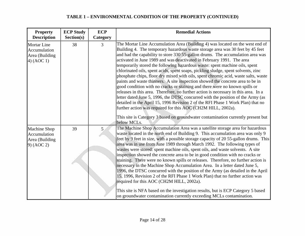
TABLE 1 – ENVIRONMENTAL CONDITION OF THE PROPERTY (CONTINUED)
Page 14 of 28
Property Description
ECP Study Section(s)
ECP Category
Remedial Actions
Mortar Line Accumulation Area (Building 4) (AOC 1)
38 3 The Mortar Line Accumulation Area (Building 4) was located on the west end of Building 4. The temporary hazardous waste storage area was 30 feet by 45 feet and had the capability to store 330 55-gallon drums. The accumulation area was activated in June 1989 and was deactivated in February 1991. The area temporarily stored the following hazardous waste: spent machine oils, spent chlorinated oils, spent acids, spent soaps, pickling sludge, spent solvents, zinc phosphate chips, floor dry mixed with oils, spent chromic acid, waste salts, waste paints and waste thinners. A site inspection showed the concrete area to be in good condition with no cracks or staining and there were no known spills or releases in this area. Therefore, no further action is necessary in this area. In a letter dated June 5, 1996, the DTSC concurred with the position of the Army (as detailed in the April 15, 1996 Revision 2 of the RFI Phase 1 Work Plan) that no further action was required for this AOC (CH2M HILL, 2002a).
This site is Category 3 based on groundwater contamination currently present but below MCLs.
Machine Shop Accumulation Area (Building 9) (AOC 2)
39 5 The Machine Shop Accumulation Area was a satellite storage area for hazardous waste located in the north end of Building 9. This accumulation area was only 9 feet by 9 feet in size, with a possible storage capacity of 20 55-gallon drums. This area was in use from June 1989 through March 1992. The following types of wastes were stored: spent machine oils, spent oils, and waste solvents. A site inspection showed the concrete area to be in good condition with no cracks or staining. There were no known spills or releases. Therefore, no further action is necessary in the Machine Shop Accumulation Area. In a letter dated June 5, 1996, the DTSC concurred with the position of the Army (as detailed in the April 15, 1996, Revision 2 of the RFI Phase 1 Work Plan) that no further action was required for this AOC (CH2M HILL, 2002a).
This site is NFA based on the investigation results, but is ECP Category 5 based on groundwater contamination currently exceeding MCLs contamination.

TABLE 1 – ENVIRONMENTAL CONDITION OF THE PROPERTY (CONTINUED)
Page 15 of 28
Property Description
ECP Study Section(s)
ECP Category
Remedial Actions
Vehicle Maintenance Accumulation Area (Building 15) (AOC 3)
40 5 The Vehicle Maintenance Accumulation Area is a hazardous waste satellite storage area located in Building 15. The area is 3 feet by 5 feet and has capacity for four 55-gallon drums. This site was activated for use in June 1989 and is still in use. Materials stored include waste oil, spent antifreeze, and waste solvent. A site inspection showed that the concrete area was in good condition with no cracks or staining. No known spills or releases have occurred in this area. Based on the small quantity of drums stored at this site and the lack of evidence of past spills or releases, no further action is deemed necessary. In a letter dated June 5, 1996, the DTSC concurred with the position of the Army (as detailed in the April 15, 1996 Revision 2 of the RFI Phase 1 Work Plan) that no further action was required for this AOC (CH2M HILL, 2002a).
This site is NFA based on the investigation results, but is ECP Category 5 based on groundwater contamination currently exceeding MCLs contamination.
Grenade Casing Line Accumulation Area (AOC 4)
41 5 The Grenade Casing Line Accumulation Area was used as hazardous waste satellite storage area. This 9-foot-by-9-foot accumulation area was located north of Building 13 and had a storage capacity of 20 55-gallon drums. This area was used from June 1989 through June 1990 for storage of waste chlorinated oil and spent caustic cleaner. The site inspection showed the concrete area to be in good condition with no cracks or staining. No known spills or releases occurred at this unit. Based on these findings, no further action is necessary in this area. In a letter dated June 5, 1996, the DTSC concurred with the position of the Army (as detailed in the April 15, 1996 Revision 2 of the RFI Phase 1 Work Plan) that no further action was required for this AOC (CH2M HILL, 2002a).
This site is NFA based on the investigation results, but is ECP Category 5 based on groundwater contamination currently exceeding MCLs contamination.
Horizontal ASTs – Propane Storage Tanks (AOC 8A)
45 5 The propane storage area consists of 16 horizontal pressure tanks used for the storage of propane liquid. The storage area is located in the northeastern end of RBAAP. Each horizontal steel tank has a 10-foot diameter, and is 50 feet long with a 30,000-gallon capacity. The propane storage tanks were built in 1952 and

TABLE 1 – ENVIRONMENTAL CONDITION OF THE PROPERTY (CONTINUED)
Page 16 of 28
Property Description
ECP Study Section(s)
ECP Category
Remedial Actions
are currently still in service. The propane storage tank area has been leased to a commercial propane vendor. No known waste has been placed in the tanks, only liquid propane, and there have not been any known releases or spills. Because this area is used only for the storage of propane and the nature of propane would be to vaporize if a release did occur, no further action is necessary in this area. In a letter dated June 5, 1996, the DTSC concurred with the position of the Army (as detailed in the April 15, 1996 Revision 2 of the RFI Phase 1 Work Plan) that no further action was required for this AOC (CH2M HILL, 2002a).
This site is NFA based on the investigation results, but is ECP Category 5 based on groundwater contamination currently exceeding MCLs contamination.
Horizontal ASTs – Transformer Oil Storage Tanks (including Transformer Oil Distribution System) (AOC 8B)
46 5 AOC 8B currently consists of a pump house (Building 85) and an abandoned underground pipeline distribution system historically used to transport transformer coolant oil to transformers. The system originally was built in the 1940s and was used until 1970. An estimated 3,500 to 4,000 feet of underground supply and return lines, made of 1.5- to 2.5-inch single-wall steel pipe, are located between the former tanks, the pump house, the former transformer locations, and Building 15. The pipelines have been cleaned (as requested by the DTSC) and encapsulated with cement slurry. Originally, three Transformer Oil Storage Tanks were used for oil storage; the three 8,000-gallon ASTs sat in reinforced concrete cradles, and all sides and the bottom of the tanks were visible. The three tanks were cleaned out, tested for PCBs, and removed from the facility. No known releases or spills occurred from this system. A visual inspection in 1997 of the tank area and other system components did not show any indication of tank release. However, during the 1997 inspection, stains of unknown origin were observed on the floor in Building 85.
Soil samples were collected in 2001 and 2003 in the bermed area that formerly held the transformer oil storage tanks, adjacent to the pipeline heading to Building 15, and adjacent to the former transformer pads and the main distribution line. Based on these results, 120 cy of soil contaminated with PCBs (as Aroclor-1260)

TABLE 1 – ENVIRONMENTAL CONDITION OF THE PROPERTY (CONTINUED)
Page 17 of 28
Property Description
ECP Study Section(s)
ECP Category
Remedial Actions
at concentrations greater than industrial preliminary remediation goals (IPRGs) were removed within the bermed area. Confirmation samples from the excavationfloor were nondetect. Based on these findings, no further action is recommended at the Oil Storage Tanks location of AOC 8B.
During the 2004 Storage Tank Area Soil Removal, additional samples were collected adjacent to former transformer pads along the distribution lines. These sample results were less than IPRGs and, combined with the prior two sets of sampling results along the distribution system, confirm that significant releases did not occur along the distribution system. The Final RFI Report recommended no further action for the transformer oil storage tanks or distribution system (CH2M HILL, 2005a). The DTSC concurred with this recommendation by approving the Final RFI Report.
This site is NFA based on the investigation results, but is ECP Category 5 based on groundwater contamination currently exceeding MCLs contamination.
Vertical ASTs – Fuel Oil Storage Tanks (AOC 9A)
47 3 There are two ASTs located side by side in the east-central portion of the installation. The two welded-steel storage tanks are 35 feet in diameter and 34 feet tall with a storage capacity of 250,000 gallons per tank. The tanks were built in November 1952 and were used through 1958 to store fuel oil. When the groundwater treatment system was installed in 1991, the tanks were converted for temporary storage of treated groundwater. The two fuel oil storage tanks were cleaned and internally inspected in 1991. The results of the visual inspection showed no signs of leakage. Additionally, the tanks were ultrasonically inspected in November 1992 and found to be sound. The associated piping is also believed to be sound. No further investigation is required in this area. In a letter dated June 5, 1996, the DTSC concurred with the position of the Army (as detailed in the April 15, 1996 Revision 2 of the RFI Phase 1 Work Plan) that no further action was required for this AOC (CH2M HILL, 2002a).
This site is Category 3 based on groundwater contamination currently present but

TABLE 1 – ENVIRONMENTAL CONDITION OF THE PROPERTY (CONTINUED)
Page 18 of 28
Property Description
ECP Study Section(s)
ECP Category
Remedial Actions
below Maximum Contaminant Levels (MCLs).
Vertical ASTs – Fire Sprinkler Storage Tank (AOC 9B)
48 1 The Fire Sprinkler Storage Tank is located in the southeast portion of RBAAP. This tank is constructed of steel with welded seams with a storage capacity of 1,000,000 gallons. The tank supplies water for the fire sprinkler system and the high-pressure (150 psi) water distribution system for the main production area. This tank never has contained waste, just water. The tank and associated piping show no signs of deterioration (other than weathering) and are believed to be sound. In a letter dated June 5, 1996, DTSC concurred with the position of the Army (as detailed in the April 15, 1996 Revision 2 of the RFI Phase 1 Work Plan) that no further action was required for this AOC.
Loading Racks – Propane Farm Loading/Unloading (AOC 11A)
50 5 This AOC consists of the two propane tank-loading racks located at the propane tank farm. Each rack is 8 feet by 6 feet and equipped with 100-gpm pumps for pumping propane to the propane tanks from railroad tanker cars. The propane farm was built in 1952 and has been in use since that time. The level of activity has varied greatly depending on the amount of onsite propane use. No waste has ever been placed in the propane farm or the loading/unloading racks. There are no known releases or spills at the loading racks. Because the physical characteristics of propane would cause it to vaporize if there was a release, there is no potential for soil or groundwater to be contaminated. In a letter dated June 5, 1996, the DTSC concurred with the position of the Army (as detailed in the April 15, 1996 Revision 2 of the RFI Phase 1 Work Plan) that no further action was required for this AOC (CH2M HILL, 2002a).
This site is NFA based on the investigation results, but is ECP Category 5 based on groundwater contamination currently exceeding MCLs contamination.
Loading Racks – Fire Sprinkler Pumping Station
51 2 The Fire Sprinkler Pumping Station consists of fire pumps and associated controls, piping, and valves. The Fire Sprinkler Pumping Station is 49 feet by 21 feet and has two 1,000-gpm pumps and two 1,000-gpm propane-powered backup

TABLE 1 – ENVIRONMENTAL CONDITION OF THE PROPERTY (CONTINUED)
Page 19 of 28
Property Description
ECP Study Section(s)
ECP Category
Remedial Actions
(AOC 11B) pumps. No waste has been placed in the Fire Sprinkler Pumping Station and no known releases or spills have occurred. In a letter dated June 5, 1996, DTSC concurred with the position of the Army (as detailed in the April 15, 1996 Revision 2 of the RFI Phase 1 Work Plan) that no further action was required for this AOC.
Industrial Wastewater Collection System (AOC 12)
52 3 The IWCS is a system of underground piping and waste sumps that historically collected industrial wastewater from the production plant and transferred it to the IWTP. The system consists of an estimated 3,500 to 4,000 linear feet of vitrified clay and cast iron pipe ranging from 4 inches to 21 inches in diameter. The sumps that were historically connected to the system were constructed of brick or concrete. The system was built after the Army acquired the production plant in 1951. The IWCS has been disconnected from the production plant. The collection sumps were filled with concrete in the late 1990s, when a new, above-grade collection system was installed.
Soil investigations involving collection of soil samples from within and adjacent to the sumps and trenches associated with production lines 2, 3, 4, and 5 were completed in accordance with the DTSC-approved work plans. Soil samples were collected from both the production line trenches and sumps. The investigations did not identify contaminants at elevated concentrations in the soil samples. During the RFI Phase 1, a video survey was conducted on the collection system pipelines and soil samples were collected near major cracks or breaks observed in the video survey (CH2M HILL, 2002a). The video survey and subsurface sampling adjacent to the IWCS did not indicate that significant leaks occurred and soil analytical results did not contain contaminants that exceeded IPRGs. The Final RFI recommended that no further action be taken along the IWCS while the IWTP is still active (CH2M HILL, 2005a). The DTSC concurred with this recommendation when they approved the Final RFI Report. In a letter from the DTSC, dated August 10, 2006, the DTSC confirmed that no further action was required for SWMU 12 (DTSC, 2006).

TABLE 1 – ENVIRONMENTAL CONDITION OF THE PROPERTY (CONTINUED)
Page 20 of 28
Property Description
ECP Study Section(s)
ECP Category
Remedial Actions
Draw Lube System (Building 178) (AOC 13)
53 5 The Draw Lube System in Building 178 is a chlorinated oil filter, heating, and cooling system. The system has an oil storage capacity of 385 gallons. It was built in 1987 and operated until 1990. In March 1993, during layaway activities for Building 13, contamination was discovered on the south side of Building 178. Thirteen soil samples were collected and elevated oil and grease concentrations were detected at two locations (three total samples). Two additional hand-auger borings were installed adjacent to Building 178 to confirm the limited extent of contamination. All samples from these borings were non-detect for TPH. A soil removal action was taken to address the petroleum-contaminated soil. The upper 3 feet of soil was excavated in an area approximately 6-feet wide by 16-feet long immediately adjacent to Building 178. Extraction well 54B is located about 100 yards downgradient from Building 178. This well was sampled several times for oil and grease in the three years following the release with all sample results being nondetect. In a letter dated June 5, 1996, the DTSC concurred with the position of the Army (as detailed in the April 15, 1996 Revision 2 of the RFI Phase 1 Work Plan) that no further action was required for this AOC (CH2M HILL, 2002a).
This site is NFA based on the investigation results, but is ECP Category 5 based on groundwater contamination currently exceeding MCLs contamination.
Zinc-Cyanide Wastewater Collection System (AOC 14)
54 3 The cyanide wastewater collection system operated from 1954 to 1958 and consists of approximately 1,400 to 1,500 feet of 4-inch to 6-inch diameter iron or vitrified clay pipe. The use of this system was discontinued due to production capability changes. The system has been disconnected from the production plant and the collection sumps filled with concrete in the late 1990s.
Soil samples collected below and near sump 6-11 at depths of 11 to 13 feet did not identify elevated cyanide contaminant concentrations. The soil investigations completed for the portions of the cyanide wastewater collection system near production lines 2 through 5 did not identify any significantly elevated concentrations (CH2M Hill, 2002). During the RFI Phase 1, a soil boring was advanced at one point along the line and no visual or analytical indication of

TABLE 1 – ENVIRONMENTAL CONDITION OF THE PROPERTY (CONTINUED)
Page 21 of 28
Property Description
ECP Study Section(s)
ECP Category
Remedial Actions
contamination was found. Coupled with the fact that this waste line only saw limited operation from 1954 to 1958, the probability of significant releases of contamination is low. Therefore, the Final RFI recommended no further action for AOC 14 (CH2M HILL, 2005a). The DTSC concurred with this recommendation by approving the Final RFI Report. In a letter from the DTSC, dated August 10, 2006, the DTSC confirmed that no further action was required for AOC 14 (DTSC, 2006).
This site is Category 3 based on groundwater contamination currently present but below MCLs.
Building 13 Temporary Wastewater Line (AOC 15)
13 3 Building 13 was not originally connected to the IWCS (AOC 12). A temporary wastewater pipeline was installed to facilitate transmission to the IWTP. The line was made of polyvinyl chloride (PVC) and operated for a relatively short period (ending when grenade casing production stopped in 1990). This line has been removed from Building 13 and is capped outside of the building. There is no documentation of any spills or releases associated with this unit. DTSC approval of the Current Conditions Report (CH2M HILL, 2002a) was considered concurrence that no further action is necessary. In a letter from the DTSC, dated August 10, 2006, the DTSC confirmed that no further action was required for AOC 15 (DTSC, 2006).
This site is Category 3 based on groundwater contamination currently present but below MCLs.
Substation 5 (AOC 16)
53, 1053 4 Substation 5 is located on the east side of the main installation, just east of the production area and just south of Building 11. Substation 5 consists of three transformers sitting on a concrete pad. The concrete pad, approximately 16 feet by 32 feet, is inside a gated, chain-link-fence enclosure that measures 44 feet by 22 feet. The concrete pad is surrounded by several feet of gravel-covered ground.
Soil samples were collected from the border of the Substation 5 transformer pad in 2001 (CH2M HILL, 2002a). Additional characterization was completed under

TABLE 1 – ENVIRONMENTAL CONDITION OF THE PROPERTY (CONTINUED)
Page 22 of 28
Property Description
ECP Study Section(s)
ECP Category
Remedial Actions
the RFI Phase 1. Soil contaminated with PCBs (as Aroclor-1260) at concentrations greater than IPRGs has been successfully removed from the gravel and soil areas surrounding Substation 5 and from the stormwater discharge basin. Confirmation samples collected in 2003 from the excavation were non-detect. Therefore, the Final RFI recommended no further action for AOC 16 (CH2M HILL, 2005a). The DTSC concurred by approving the Final RFI Report. In a letter from the DTSC, dated August 10, 2006, the DTSC confirmed that no further action was required for AOC 16 (DTSC, 2006).
Building 1 1001 7 None. Category 7 based on the potential for the soil beneath the remaining sumps or pits to be impacted by hazardous substances.
Building 6 1006 7 None. Category 7 based on the potential for the soil beneath the remaining sumps or pits to be impacted by hazardous substances.
Building 8 1008 7 None. Category 7 based on the potential for the soil beneath the remaining sumps or pits to be impacted by hazardous substances.
Paint and Oil Storage, Oil Recycling and Transport (Building 11)
1011 3 As a part of the EBS (Norris-Riverbank Environmental, 1998a), five near-surface soil samples were collected from the graveled areas just outside Building 11 along the southern and western sides. Aroclor 1260 was identified in all five sample results, in concentrations ranging from 400 μg/kg to 1,000 μg/kg.
This area was further investigated in the 2007 SI (CH2M HILL, 2008). The SI samples show a single detection of Aroclor 1260 at a concentration of 38 μg/kg, which is well below the industrial and residential PRGs and TSCA cleanup requirements. These sampling results indicate that the area of soil contaminated with PCBs above regulatory screening criteria is localized in nature. Although the source of the PCBs in soil is not known, two electric substations in close proximity to the areas sampled have been reported. Since the area is covered with asphalt, the current contact exposure pathway to soils is minimized and no further action is recommended. EPA Region 9 concurred with these findings in a letter dated 14 December 2007.
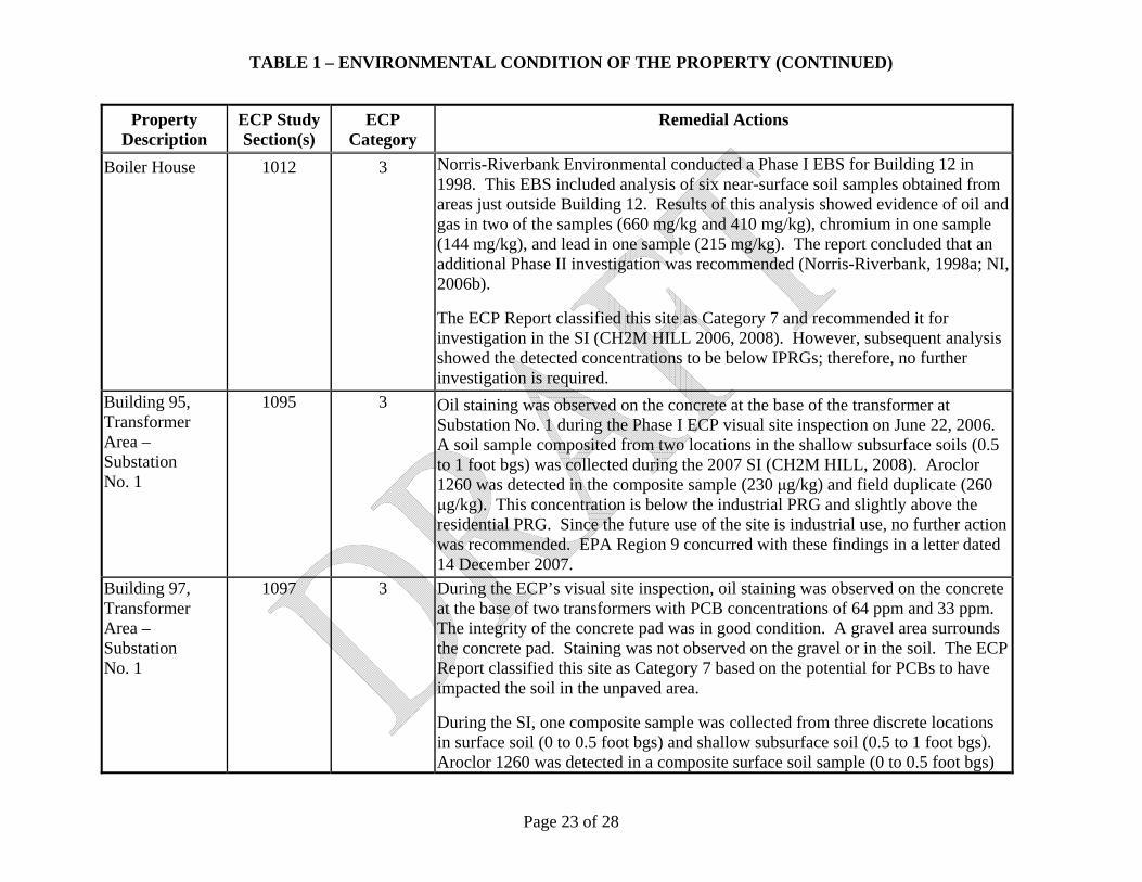
TABLE 1 – ENVIRONMENTAL CONDITION OF THE PROPERTY (CONTINUED)
Page 23 of 28
Property Description
ECP Study Section(s)
ECP Category
Remedial Actions
Boiler House 1012 3 Norris-Riverbank Environmental conducted a Phase I EBS for Building 12 in 1998. This EBS included analysis of six near-surface soil samples obtained from areas just outside Building 12. Results of this analysis showed evidence of oil and gas in two of the samples (660 mg/kg and 410 mg/kg), chromium in one sample (144 mg/kg), and lead in one sample (215 mg/kg). The report concluded that an additional Phase II investigation was recommended (Norris-Riverbank, 1998a; NI, 2006b).
The ECP Report classified this site as Category 7 and recommended it for investigation in the SI (CH2M HILL 2006, 2008). However, subsequent analysis showed the detected concentrations to be below IPRGs; therefore, no further investigation is required.
Building 95, Transformer Area – Substation No. 1
1095 3 Oil staining was observed on the concrete at the base of the transformer at Substation No. 1 during the Phase I ECP visual site inspection on June 22, 2006. A soil sample composited from two locations in the shallow subsurface soils (0.5 to 1 foot bgs) was collected during the 2007 SI (CH2M HILL, 2008). Aroclor 1260 was detected in the composite sample (230 μg/kg) and field duplicate (260 μg/kg). This concentration is below the industrial PRG and slightly above the residential PRG. Since the future use of the site is industrial use, no further action was recommended. EPA Region 9 concurred with these findings in a letter dated 14 December 2007.
Building 97, Transformer Area – Substation No. 1
1097 3 During the ECP’s visual site inspection, oil staining was observed on the concrete at the base of two transformers with PCB concentrations of 64 ppm and 33 ppm. The integrity of the concrete pad was in good condition. A gravel area surrounds the concrete pad. Staining was not observed on the gravel or in the soil. The ECP Report classified this site as Category 7 based on the potential for PCBs to have impacted the soil in the unpaved area.
During the SI, one composite sample was collected from three discrete locations in surface soil (0 to 0.5 foot bgs) and shallow subsurface soil (0.5 to 1 foot bgs). Aroclor 1260 was detected in a composite surface soil sample (0 to 0.5 foot bgs)

TABLE 1 – ENVIRONMENTAL CONDITION OF THE PROPERTY (CONTINUED)
Page 24 of 28
Property Description
ECP Study Section(s)
ECP Category
Remedial Actions
at a concentration (330 μg/kg) exceeding the residential PRG but well below the industrial PRG. The deeper sample collected from 0.5 to 1 foot bgs contained Aroclor 1260 at a concentration of 23 μg/kg, which is well below the industrial and residential PRGs. Based on the future industrial use, the SI recommended no further action for this site. EPA Region 9 concurred with these findings in a letter dated 14 December 2007.
Building 101, Transformer Area – Substation Spare
1101 3 During the ECP’s visual site inspection, oil staining was observed on concrete at the base of one inactive transformer with an unknown PCB concentration. No staining was observed in the gravel areas adjacent to the concrete pad. The pad appeared to be good condition. The ECP Report classified this site as Category 7 based on the potential for PCBs to have impacted the soil in the unpaved area.
During the SI, one composite sample was collected from three discrete locations in surface soil (0 to 0.5 foot bgs) and shallow subsurface soil (0.5 to 1 foot bgs). Aroclor 1260 was detected in the composite surface soil sample at a concentration of 1,900 μg/kg, which exceeds industrial and residential PRGs. However, in the 0.5 to 1 foot bgs sample, the Aroclor 1260 concentration of 33 μg/kg is well below the industrial and residential PRGs.
The SI recommended no further action for this site based on the following factors:• While exceeding the industrial PRG, the PCB concentration in soil is well
below TSCA requirements. Under TSCA in 40 CFR 761.61, PCB concentrations may remain in soils up to 50,000 μg/kg in low-occupancy outdoor electrical substation areas.
• PCB concentrations in deeper soils are well below the industrial and residential PRGs, indicating that the contamination is superficial.
• Land use is currently industrial and expected to remain industrial. • Access restrictions limit the potential for exposure to this area.
EPA Region 9 concurred with these findings in a letter dated 14 December 2007.

TABLE 1 – ENVIRONMENTAL CONDITION OF THE PROPERTY (CONTINUED)
Page 25 of 28
Property Description
ECP Study Section(s)
ECP Category
Remedial Actions
Building 138, Transformer Substation No. 16
1138 1 None required.
Building 139, Water Storage Tank
1139 1 None required.
Building 145, Transformer Substation No. 17
1145 3 During the ECP’s visual site inspection, oil staining was observed on the concrete at the base of two transformers with PCB concentrations of 28 ppm and 134 ppm. The integrity of the concrete pad showed minor cracking. A gravel area surrounds the concrete pad. The ECP Report classified this site as Category 7 based on the potential for PCBs to have impacted the soil in the unpaved area and beneath the concrete pad.
One composite sample (from three discrete points) was collected from surface soil (0 to 0.5 foot bgs) and shallow subsurface soil (0.5 to 1 foot bgs) along the northern side of the concrete pad, which slopes toward the north. In addition to the composite sample, two discrete surface soil (0 to 0.5 foot bgs) and shallow subsurface soil (0.5 to 1 foot bgs) samples were collected on the north and south sides of the concrete pad where stained gravel was observed.
Aroclor 1260 was the only PCB detected in samples collected near the substation. Aroclor 1260 concentrations exceed residential and industrial PRGs in one discreet surface soil sample at 2,000 μg/kg, and in the composite surface soil sample at 9,500 μg/kg. In the remaining samples, the Aroclor 1260 concentrations were below the industrial PRG, or in some cases, below both the industrial and residential PRGs.
Although the PCB concentrations exceeded the industrial PRG, the results are well below TSCA requirements of 50,000 μg/kg in low occupancy outdoor electrical substation areas. Future use of this area is expected to be industrial, and

TABLE 1 – ENVIRONMENTAL CONDITION OF THE PROPERTY (CONTINUED)
Page 26 of 28
Property Description
ECP Study Section(s)
ECP Category
Remedial Actions
the substation area access is controlled by a locked fence with signage. The substation has to be de-energized for access to be permitted and thus, access is strictly controlled. As a result, the SI recommended no further action for this site. EPA Region 9 concurred with these findings in a letter dated 14 December 2007.
West Parking 2002 5 Category 5 based on groundwater contamination currently exceeding MCLs.
North Utilities 2004 3 Category 3 based on groundwater contamination currently present but below MCLs.
West Utilities 2005 5 Category 5 based on groundwater contamination currently exceeding MCLs.
East Utilities 2006 5 Category 5 based on groundwater contamination currently exceeding MCLs.
Southeast Utilities
2007 3 Category 3 based on groundwater contamination currently present but below MCLs.
South Utilities 2008 5 Category 5 based on groundwater contamination currently exceeding MCLs.
North Open Storage
2009 5 Category 5 based on groundwater contamination currently exceeding MCLs.
West Open Storage
2010 3 Category 3 based on groundwater contamination currently present but below MCLs.
Central Storage 2011 5 Category 5 based on groundwater contamination currently exceeding MCLs.
North Warehouse Storage
2013 5 Category 5 based on groundwater contamination currently exceeding MCLs.
West Warehouse Storage
2014 5 Category 5 based on groundwater contamination currently exceeding MCLs.
Water Storage 2015 5 Category 5 based on groundwater contamination currently exceeding MCLs.

TABLE 1 – ENVIRONMENTAL CONDITION OF THE PROPERTY (CONTINUED)
Page 27 of 28
Property Description
ECP Study Section(s)
ECP Category
Remedial Actions
South Warehouse Storage
2016 3 Category 3 based on groundwater contamination currently present but below MCLs.
West Railroad Storage
2017 3 Category 3 based on groundwater contamination currently present but below MCLs.
East Railroad Storage
2018 3 Category 3 based on groundwater contamination currently present but below MCLs.
Fuel Storage 2019 5 Category 5 based on groundwater contamination currently exceeding MCLs.
Hazardous Waste Storage
2020 5 Category 5 based on groundwater contamination currently exceeding MCLs.
Administration Open Area
2021 5 Category 5 based on groundwater contamination currently exceeding MCLs.
Medical Open Area
2022 5 Category 5 based on groundwater contamination currently exceeding MCLs.
Production Open Area
2023 5 Category 5 based on groundwater contamination currently exceeding MCLs.
E/P Ponds Soil Staining Area
2024 5 Preliminary soil samples indicated levels of motor oil at concentrations of 276,000mg/kg. The U.S. Army is investigating and pursuing clean-up efforts for the site.
Category 1: Areas where no release or disposal of hazardous substances or petroleum products has occurred (including no migration of these substances from adjacent areas).
Category 2: Areas where only release or disposal of petroleum products has occurred.
Category 3: Areas where release, disposal, and/or migration of hazardous substances has occurred, but at concentrations that do not require a removal or remedial response.
Category 4: Areas where release, disposal, and/or migration of hazardous substances has occurred, and all removal or remedial actions to protect human health and the environment have been taken.
Category 5: Areas where a release, disposal, and/or migration of hazardous substances has occurred, and removal or remedial actions

TABLE 1 – ENVIRONMENTAL CONDITION OF THE PROPERTY (CONTINUED)
Page 28 of 28
are underway but all required remedial actions have not yet taken place.
Category 6: Areas where a release, disposal, and/or migration of hazardous substances has occurred, but required actions have not yet been implemented.
Category 7: Areas that are not evaluated or require additional evaluation.

Page 1 of 19
ENCLOSURE 4
TABLE 2 – NOTIFICATION OF HAZARDOUS SUBSTANCE STORAGE, RELEASE, OR DISPOSAL
Description Name of Hazardous
Substance(s)
Date of Storage, Release, or
Disposal
Remedial Actions
Three, 11,500-gallon steel ASTs located at Bldgs. 4,5, and 6.
Cyanide Unknown These tanks were decontaminated, dismantled, and disposed of. This is documented in the Closure of Three Cyanide Tanks at Building 4, 5, and 6 Report (Norris-Riverbank, 1998h).
Tank No. G71, a 1,200-gallon steel tank, is located at Bldg. 44 (IWTP)
Hazardous waste 1996 - present None.
G2 (Bldg. 44) Equalization Tank 1970s - present Industrial Wastewater Treatment Plant (IWTP) Process Tank. Investigation of this unit will be conducted at permit closure.
G7 (Bldg. 44) Reactor Clarifier 1970s - present IWTP Process Tank. Investigation of this unit will be conducted at permit closure.
G8 (Bldg. 44) Thickener 1970s - present IWTP Process Tank. Investigation of this unit will be conducted at permit closure.
Tank No. 6, a 900-gallon concrete tank (Bldg. 170)
Pesticides Unknown – 1994 Tank removed.
Tank No. 12, a 1,300-gallon steel tank (Bldg. 7)
Slurry water, Asbestos cuttings
Unknown – 1994 Tank removed.
Tank No. 22, an 800-gallon tank, located at Bldg. 1
Paint Unknown – 1973 Tank closed in place.

TABLE 2 – NOTIFICATION OF HAZARDOUS SUBSTANCE STORAGE, RELEASE, OR DISPOSAL (CONTINUED)
Page 2 of 19
Description Name of Hazardous
Substance(s)
Date of Storage, Release, or
Disposal
Remedial Actions
Tank No. 23, an 800-gallon tank, located at Bldg. 1
Paint Unknown – 1973 Tank closed in place.
Tank No. 24, a 990-gallon steel tank, located at Bldg. 2
Varnish Unknown – 1995 Tank closed in place.
Tank No. 25, an 880-gallon steel tank, located at Bldg. 2
Varnish Unknown – 1995 Tank closed in place.
Tank No. 26, a 1,585-gallon steel tank, located at Bldg. 160
Varnish Unknown – 1994 Tank removed.
Tank No. 27, a 1,585-gallon steel tank, located at Bldg. 3
Varnish Unknown – 1994 Tank closed in place.
Tank No. 28, a 2,115-gallon steel tank, located at Bldg. 4
Varnish Unknown – 1995 Tank closed in place.
Tank No. 29, a 1,585-gallon steel tank, located at Bldg. 4
Varnish Unknown – 1995 Tank closed in place.
Tank No. 30, a 3,300-gallon steel tank, located at Bldg. 5
Varnish Unknown – 1995 Tank closed in place.
Tank No. 31, a 3,000-gallon steel tank, located at Bldg. 5
Varnish Unknown – 1995 Tank closed in place.
Tank No. 32, a 3,300-gallon steel tank, located at Bldg. 6
Varnish Unknown – 1995 Tank closed in place.
Tank No. 33, a 3,000-gallon steel tank, located at Bldg. 6
Varnish Unknown – 1995 Tank closed in place.
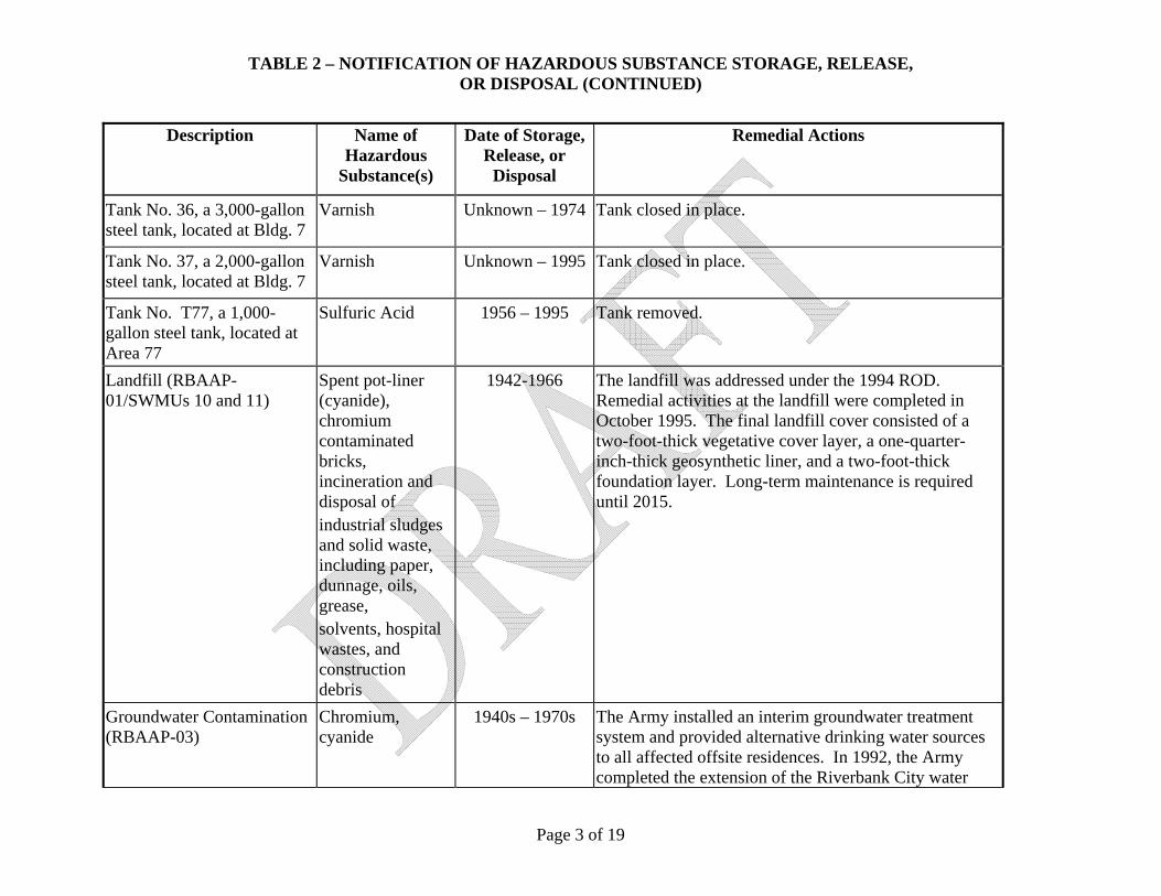
TABLE 2 – NOTIFICATION OF HAZARDOUS SUBSTANCE STORAGE, RELEASE, OR DISPOSAL (CONTINUED)
Page 3 of 19
Description Name of Hazardous
Substance(s)
Date of Storage, Release, or
Disposal
Remedial Actions
Tank No. 36, a 3,000-gallon steel tank, located at Bldg. 7
Varnish Unknown – 1974 Tank closed in place.
Tank No. 37, a 2,000-gallon steel tank, located at Bldg. 7
Varnish Unknown – 1995 Tank closed in place.
Tank No. T77, a 1,000-gallon steel tank, located at Area 77
Sulfuric Acid 1956 – 1995 Tank removed.
Landfill (RBAAP-01/SWMUs 10 and 11)
Spent pot-liner (cyanide), chromium contaminated bricks, incineration and disposal of industrial sludges and solid waste, including paper, dunnage, oils, grease, solvents, hospital wastes, and construction debris
1942-1966 The landfill was addressed under the 1994 ROD. Remedial activities at the landfill were completed in October 1995. The final landfill cover consisted of a two-foot-thick vegetative cover layer, a one-quarter-inch-thick geosynthetic liner, and a two-foot-thick foundation layer. Long-term maintenance is required until 2015.
Groundwater Contamination (RBAAP-03)
Chromium, cyanide
1940s – 1970s The Army installed an interim groundwater treatment system and provided alternative drinking water sources to all affected offsite residences. In 1992, the Army completed the extension of the Riverbank City water
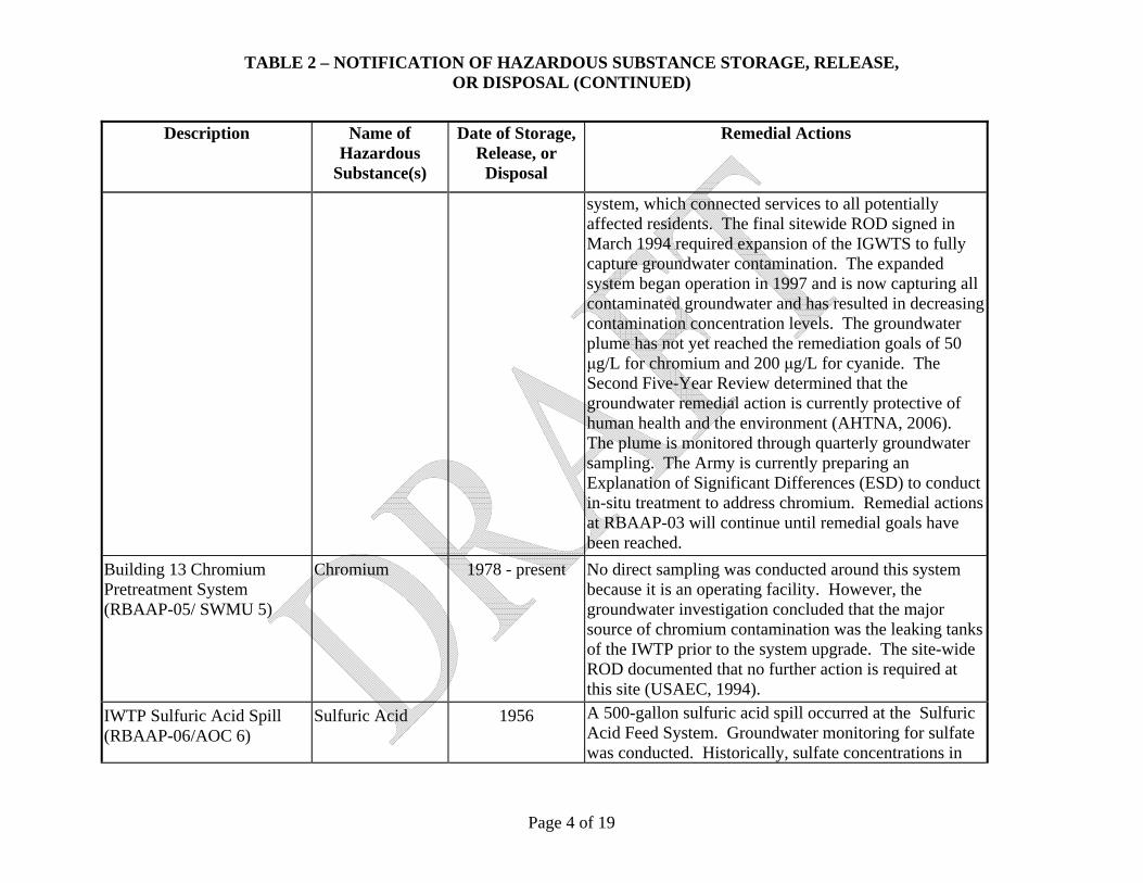
TABLE 2 – NOTIFICATION OF HAZARDOUS SUBSTANCE STORAGE, RELEASE, OR DISPOSAL (CONTINUED)
Page 4 of 19
Description Name of Hazardous
Substance(s)
Date of Storage, Release, or
Disposal
Remedial Actions
system, which connected services to all potentially affected residents. The final sitewide ROD signed in March 1994 required expansion of the IGWTS to fully capture groundwater contamination. The expanded system began operation in 1997 and is now capturing all contaminated groundwater and has resulted in decreasing contamination concentration levels. The groundwater plume has not yet reached the remediation goals of 50 μg/L for chromium and 200 μg/L for cyanide. The Second Five-Year Review determined that the groundwater remedial action is currently protective of human health and the environment (AHTNA, 2006). The plume is monitored through quarterly groundwater sampling. The Army is currently preparing an Explanation of Significant Differences (ESD) to conduct in-situ treatment to address chromium. Remedial actions at RBAAP-03 will continue until remedial goals have been reached.
Building 13 Chromium Pretreatment System (RBAAP-05/ SWMU 5)
Chromium 1978 - present No direct sampling was conducted around this system because it is an operating facility. However, the groundwater investigation concluded that the major source of chromium contamination was the leaking tanks of the IWTP prior to the system upgrade. The site-wide ROD documented that no further action is required at this site (USAEC, 1994).
IWTP Sulfuric Acid Spill (RBAAP-06/AOC 6)
Sulfuric Acid 1956 A 500-gallon sulfuric acid spill occurred at the Sulfuric Acid Feed System. Groundwater monitoring for sulfate was conducted. Historically, sulfate concentrations in
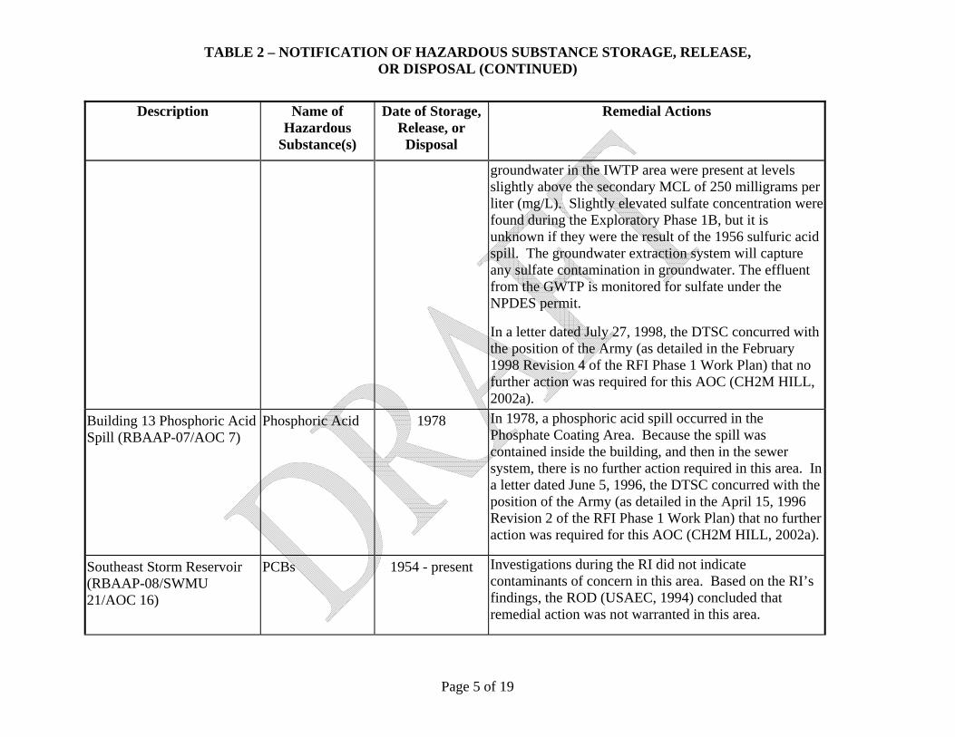
TABLE 2 – NOTIFICATION OF HAZARDOUS SUBSTANCE STORAGE, RELEASE, OR DISPOSAL (CONTINUED)
Page 5 of 19
Description Name of Hazardous
Substance(s)
Date of Storage, Release, or
Disposal
Remedial Actions
groundwater in the IWTP area were present at levels slightly above the secondary MCL of 250 milligrams per liter (mg/L). Slightly elevated sulfate concentration were found during the Exploratory Phase 1B, but it is unknown if they were the result of the 1956 sulfuric acid spill. The groundwater extraction system will capture any sulfate contamination in groundwater. The effluent from the GWTP is monitored for sulfate under the NPDES permit.
In a letter dated July 27, 1998, the DTSC concurred with the position of the Army (as detailed in the February 1998 Revision 4 of the RFI Phase 1 Work Plan) that no further action was required for this AOC (CH2M HILL, 2002a).
Building 13 Phosphoric Acid Spill (RBAAP-07/AOC 7)
Phosphoric Acid 1978 In 1978, a phosphoric acid spill occurred in the Phosphate Coating Area. Because the spill was contained inside the building, and then in the sewer system, there is no further action required in this area. In a letter dated June 5, 1996, the DTSC concurred with the position of the Army (as detailed in the April 15, 1996 Revision 2 of the RFI Phase 1 Work Plan) that no further action was required for this AOC (CH2M HILL, 2002a).
Southeast Storm Reservoir (RBAAP-08/SWMU 21/AOC 16)
PCBs 1954 - present Investigations during the RI did not indicate contaminants of concern in this area. Based on the RI’s findings, the ROD (USAEC, 1994) concluded that remedial action was not warranted in this area.

TABLE 2 – NOTIFICATION OF HAZARDOUS SUBSTANCE STORAGE, RELEASE, OR DISPOSAL (CONTINUED)
Page 6 of 19
Description Name of Hazardous
Substance(s)
Date of Storage, Release, or
Disposal
Remedial Actions
However, a sample was subsequently collected in the reservoir for PCB analysis (associated with the investigation of AOC 16 (Substation 5)). PCBs were detected at 4.5 mg/kg and additional sampling was conducted as part of the RFI at AOC 16. Soil removal was conducted as part of the removal action at AOC 16. The Final RFI Report recommended no further action for this SWMU (CH2M HIL, 2005a). The DTSC concurred by approving the Final RFI Report.
Percolation/Evaporation Ponds (E/P Ponds) (RBAAP-11/ SWMU 23)
Zinc, TPH 1952 - present Based on the RI findings, a removal action was completed in 1993 to address zinc-contaminated soil. The ROD documented this removal action and concluded that no further action was necessary at the ponds (USAEC, 1994). RBAAP continues to use the E/P Ponds for discharge of treated water. This discharge is regulated under Waste Discharge Requirements (WDRs) issued by the Central Valley Water Board. The WDRs require ongoing groundwater monitoring at the E/P Ponds.
Industrial Wastewater Treatment Plant (SWMU 1)
Chromium, cyanide
1951 – present Since 1972, numerous upgrades and improvements have been implemented at the IWTP. The redwood equalization tanks were replaced with a concrete equalization basin in 1980. The redwood tanks were the source of the chromium and cyanide contamination in the IWTP area.
The Phase I RI, conducted between January 1987 and November 1998, included two soil borings at the IWTP. Samples were analyzed for total and hexavalent

TABLE 2 – NOTIFICATION OF HAZARDOUS SUBSTANCE STORAGE, RELEASE, OR DISPOSAL (CONTINUED)
Page 7 of 19
Description Name of Hazardous
Substance(s)
Date of Storage, Release, or
Disposal
Remedial Actions
chromium, total and free cyanide, and 1,1-DCE. Soil borings SB-14 and SB-15 were advanced to a depth of 50 feet bgs in the area where the former redwood tanks were located. At SB-14, total chromium was detected at a concentration of 23.5 mg/kg at 40 feet bgs, and 18.0 mg/kg at 50 feet bgs. At SB-15, total chromium was detected at a concentration of 22.15 mg/kg t 40 feet bgs, and 55.83 mg/kg at 50 feet bgs (Weston, 1991).
The IWTP remains an active unit. The DTSC (in a letter dated July 27, 1998) states that additional characterization of soil at the IWTP is precluded by existing equipment. Additional characterization of the IWTP is precluded until permit closure due to the presence of existing system components. The groundwater under the IWTP is being addressed under the site RBAAP-03.
Hazardous Waste Storage Area (Drum Storage Facility) (SWMU 2)
Hazardous waste drums (flammable, caustics, and acids)
Unknown No known spills have been recorded in this facility. The Hazardous Waste Storage Area is regulated under the RCRA Part B permit. RCRA closure is required for this unit. The DTSC concurred with the position of the Army (as detailed in the original October 30, 1995, version of the RFI Phase 1 Work Plan) that no further action was required for this unit (CH2M HILL, 2002a).
Drum Staging Area (IWTP) (SWMU 4)
Hazardous waste drums
1990 - present There is no indication that has been a release to the environment through the paved surface. Soil samples indicated no detections above background. The Army, in Revision 4 of the RFI Phase 1 Work Plan dated February
TABLE 2 – NOTIFICATION OF HAZARDOUS SUBSTANCE STORAGE, RELEASE, OR DISPOSAL (CONTINUED)
Page 8 of 19
Description Name of Hazardous
Substance(s)
Date of Storage, Release, or
Disposal
Remedial Actions
1998, presented justification supporting a finding that no further action is recommended for this unit at this time (SOTA, 1998). The DTSC (in a letter dated July 27, 1998) concurred with this recommendation (CH2M HILL, 2002a).
Chromium Reduction Units (Building 13) (SWMU 5)
Chromic acid, sodium metabisulfide
1978 – present No evidence was found that any releases occurred from this unit. DTSC concurred with the position of the Army, as detailed in the original version of the RFI Phase 1 Work Plan, that no further action was required at the Chromium Reduction Units in Buildings 13 and 1 (CH2M HILL, 2002a).
Chromium Reduction Units (Building 1) (SWMU 6)
Chromic acid, sodium metabisulfide
1978 – present No evidence was found that any releases occurred from these units. DTSC concurred with the position of the Army, as detailed in the original version of the RFI Phase 1 Work Plan, that no further action was required at the Chromium Reduction Units in Buildings 13 and 1 (CH2M HILL, 2002a).
Coolant Recovery Unit (IWTP) (Hyde Ultrafiltration Unit) (SWMU 7)
Coolant 1989 – early 1990s
No releases from the coolant recovery unit have been documented. In RFI Phase 1, the small collection sump was steam cleaned and visually inspected for cracks or holes in the concrete. No cracks or holes were discovered and the unit was recommended for closure with no further action. In a letter from the DTSC, dated August 10, 2006, the DTSC confirmed that no further action was required for SWMU 7 (DTSC, 2006).
Equipment Wash Facility (Building 177 Triple Rinse
Hazardous waste drums
Unknown The rinse waters are collected in a sump and pumped to an oil/water separator, then pumped to the IWTP for

TABLE 2 – NOTIFICATION OF HAZARDOUS SUBSTANCE STORAGE, RELEASE, OR DISPOSAL (CONTINUED)
Page 9 of 19
Description Name of Hazardous
Substance(s)
Date of Storage, Release, or
Disposal
Remedial Actions
Area) (SWMU 9) further treatment. DTSC concurred with the position of the Army (as detailed in the original October 30, 1995, version of the RFI Phase 1 Work Plan) that no further action was required for the Equipment Wash Facility (CH2M HILL, 2002a).
Pesticide Storage Area (Building 165) (SWMU 16)
Pesticides 1975 -1979 No releases have been reported for this unit. During previous investigations of the unit, no evidence of spills or releases were noted, and the concrete floor was in good condition. This unit was periodically washed down with a hose.
Soil sampling was conducted in 2001 to assess the potential for historic releases from the building. Based on these results, additional characterization was included in the RFI Phase 1 Work Plan submitted to the DTSC in September 2002. The 2002 sampling activities in and immediately around Building 165 reported only trace detections of pesticides on the north side of the building. None of the reported detections exceeded IPRGs. Subsequent step out and step down samples collected for pesticide and herbicide analyses contained only trace detections (all below IPRGs) of pesticides in one sample. Herbicides were not detected above reporting limits in any of the samples collected (CH2M HILL, 2002a). Additional soil sampling adjacent to Building 165 confirmed the presence of chlordane in a composite sample from one side of the building. Based on the sampling results, the Final RFI Report recommended no further action be taken for this SWMU (CH2M HILL,

TABLE 2 – NOTIFICATION OF HAZARDOUS SUBSTANCE STORAGE, RELEASE, OR DISPOSAL (CONTINUED)
Page 10 of 19
Description Name of Hazardous
Substance(s)
Date of Storage, Release, or
Disposal
Remedial Actions
2005a). The DTSC concurred by approving the Final RFI Report.
Pesticide Storage Area (Building 170) (SWMU 17)
Pesticides 1979 - present The concrete sump was removed in December 1994 under the oversight of the Stanislaus County Environmental Resources Department. During the removal process, the concrete material of the sump and the surrounding soil was sampled. The soil sample contained chlordane, so approximately 20 yards of soil were excavated for disposal. Visual inspection of the concrete sump did not reveal any holes, cracks, or deterioration of the walls or floor of the sump. Because the concrete floor of the building was in good condition (without cracks or stains) and the sump had been removed, no sampling was performed during the RI (NI, 2006b). In a letter dated June 5, 1996, the DTSC concurred with the position of the Army (as detailed in the April 15, 1996 Revision 2 of the RFI Phase 1 Work Plan) that no further action was required at the Pesticide Storage Area in Building 170 (CH2M HILL, 2002a).
Waste Zinc-Cyanide Solution Neutralizing Tanks (SWMU 19)
Zinc, cyanide 1955 - 1958 No evidence exists that a release ever occurred from this unit in the short period of operation (1955 through 1958). Both tanks were removed on September 27, 1994. The Army, in Revision 4 of the RFI Phase 1 Work Plan, presented justification supporting a finding that no further action is recommended at the Waste Zinc-Cyanide Solution Neutralizing Tanks. The DTSC (in a letter dated July 27, 1998) concurred with this recommendation (CH2M HILL, 2002a).

TABLE 2 – NOTIFICATION OF HAZARDOUS SUBSTANCE STORAGE, RELEASE, OR DISPOSAL (CONTINUED)
Page 11 of 19
Description Name of Hazardous
Substance(s)
Date of Storage, Release, or
Disposal
Remedial Actions
Industrial Waste Pipe Leak (SWMU 24)
Industrial wastewater
1990 An industrial waste pipe leak occurred in 1990 at the southern end of Building 13. This pipe carries wastewater from the chromium reduction unit in Building 13 to the IWTP. The soil was excavated in conjunction with the repairs. The excavation area was then sampled during the RI to determine if residual contamination existed. Sample results indicated that elevated levels of inorganics did not exist in this area. The ROD concluded that remedial action was not warranted (USAEC, 1994). The DTSC concurred with the position of the Army (as detailed in the original October 30, 1995 version of the RFI Phase 1 Work Plan) that no further action was required at the Industrial Waste Pipe Leak (CH2M HILL, 2002a).
Mortar Line Accumulation Area (Building 4) (AOC 1)
Spent machine oils, spent chlorinated oils, spent acids, spent soaps, pickling sludge, spent solvents, zinc phosphate chips, floor dry mixed with oils, spent chromic acid, waste salts, waste paints and waste thinners
1989 - 1991 A site inspection showed the concrete area to be in good condition with no cracks or staining and there were no known spills or releases in this area. Therefore, no further action is necessary in this area. In a letter dated June 5, 1996, the DTSC concurred with the position of the Army (as detailed in the April 15, 1996 Revision 2 of the RFI Phase 1 Work Plan) that no further action was required for this AOC (CH2M HILL, 2002a).

TABLE 2 – NOTIFICATION OF HAZARDOUS SUBSTANCE STORAGE, RELEASE, OR DISPOSAL (CONTINUED)
Page 12 of 19
Description Name of Hazardous
Substance(s)
Date of Storage, Release, or
Disposal
Remedial Actions
Machine Shop Accumulation Area (Building 9) (AOC 2)
Spent machine oils, spent oils, and waste solvents
1989 - 1992 A site inspection showed the concrete area to be in good condition with no cracks or staining. There were no known spills or releases. Therefore, no further action is necessary in the Machine Shop Accumulation Area. In a letter dated June 5, 1996, the DTSC concurred with the position of the Army (as detailed in the April 15, 1996 Revision 2 of the RFI Phase 1 Work Plan) that no further action was required for this AOC (CH2M HILL, 2002a).
Vehicle Maintenance Accumulation Area (Building 15) (AOC 3)
Waste oil, spent antifreeze, and waste solvent
1989 – present A site inspection showed that the concrete area was in good condition with no cracks or staining. No known spills or releases have occurred in this area. Based on the small quantity of drums stored at this site and the lack of evidence of past spills or releases, no further action is deemed necessary. In a letter dated June 5, 1996, the DTSC concurred with the position of the Army (as detailed in the April 15, 1996 Revision 2 of the RFI Phase 1 Work Plan) that no further action was required for this AOC (CH2M HILL, 2002a).
Grenade Casing Line Accumulation Area (AOC 4)
Waste chlorinated oil, spent caustic cleaner
1989 - 1990 A site inspection showed the concrete area to be in good condition with no cracks or staining. No known spills or releases occurred at this unit. Based on these findings, no further action is necessary in this area. In a letter dated June 5, 1996, the DTSC concurred with the position of the Army (as detailed in the April 15, 1996 Revision 2 of the RFI Phase 1 Work Plan) that no further action was required for this AOC (CH2M HILL, 2002a).
Horizontal ASTs – Transformer Oil Storage Tanks (including
Coolant oil, transformer oil
1940s - 1970 AOC 8B currently consists of a pump house (Building 85) and an abandoned underground pipeline distribution system historically used to transport transformer coolant

TABLE 2 – NOTIFICATION OF HAZARDOUS SUBSTANCE STORAGE, RELEASE, OR DISPOSAL (CONTINUED)
Page 13 of 19
Description Name of Hazardous
Substance(s)
Date of Storage, Release, or
Disposal
Remedial Actions
Transformer Oil Distribution System) (AOC 8B)
oil to transformers. The pipelines have been cleaned (as requested by the DTSC) and encapsulated with cement slurry. Originally, three Transformer Oil Storage Tanks were used for oil storage; the three 8,000-gallon ASTs sat in reinforced concrete cradles, and all sides and the bottom of the tanks were visible. The three tanks were cleaned out, tested for PCBs, and removed from the facility. No known releases or spills occurred from this system. A visual inspection in 1997 of the tank area and other system components did not show any indication of tank release. However, during the 1997 inspection, stains of unknown origin were observed on the floor in Building 85.
Soil samples were collected in 2001 and 2003 in the bermed area that formerly held the transformer oil storage tanks, adjacent to the pipeline heading to Building 15, and adjacent to the former transformer pads and the main distribution line. Based on these results, 120 cy of soil contaminated with PCBs (as Aroclor-1260) at concentrations greater than IPRGs were removed within the bermed area. Confirmation samples from the excavation floor were nondetect. Based on these findings, no further action is recommended at the Oil Storage Tanks location of AOC 8B.
During the 2004 Storage Tank Area Soil Removal, additional samples were collected adjacent to former transformer pads along the distribution lines. These

TABLE 2 – NOTIFICATION OF HAZARDOUS SUBSTANCE STORAGE, RELEASE, OR DISPOSAL (CONTINUED)
Page 14 of 19
Description Name of Hazardous
Substance(s)
Date of Storage, Release, or
Disposal
Remedial Actions
sample results were less than IPRGs and, combined with the prior two sets of sampling results along the distribution system, confirm that significant releases did not occur along the distribution system. The Final RFI Report recommended no further action for the transformer oil storage tanks including the distribution system (CH2M HILL, 2005a). The DTSC concurred with this recommendation by approving the Final RFI Report.
Industrial Wastewater Collection System (AOC 12)
Industrial wastewater
1951 – 1990s The IWCS has been disconnected from the production plant. The collection sumps were filled with concrete in the late 1990s, when a new, above-grade collection system was installed.
Soil investigations involving collection of soil samples from within and adjacent to the sumps and trenches associated with production lines 2, 3, 4, and 5 were completed in accordance with the DTSC-approved work plans. Soil samples were collected from both the production line trenches and sumps. The investigations did not identify contaminants at elevated concentrations in the soil samples. During the RFI Phase 1, a video survey was conducted on the collection system pipelines and then soil samples were collected near major cracks or breaks observed in the video survey (CH2M HILL, 2002a). The video survey and subsurface sampling adjacent to the IWCS did not indicate that significant leaks occurred andoil analytical results did not contain

TABLE 2 – NOTIFICATION OF HAZARDOUS SUBSTANCE STORAGE, RELEASE, OR DISPOSAL (CONTINUED)
Page 15 of 19
Description Name of Hazardous
Substance(s)
Date of Storage, Release, or
Disposal
Remedial Actions
contaminants that exceeded IPRGs. The Final RFI recommended that no further action be taken along the IWCS while the IWTP is still active (CH2M HILL, 2005a). The DTSC concurred with this recommendation when they approved the Final RFI Report. In a letter from the DTSC, dated August 10, 2006, the DTSC confirmed that no further action was required for SWMU 12 (DTSC, 2006).
Zinc-Cyanide Wastewater Collection System (AOC 14)
Cyanide wastewater
1954 - 1958 The use of the cyanide wastewater collection system was discontinued due to production capability changes. The system has been disconnected from the production plant. The collection sumps were filled with concrete in the late 1990s.
Soil samples collected below and near sump 6-11 at depths of 11 to 13 feet did not identify elevated cyanide contaminant concentrations. The soil investigations completed for the portions of the cyanide wastewater collection system near production lines 2 through 5 did not identify any significantly elevated concentrations (CH2M Hill, 2002). During the RFI Phase 1, a soil boring was advanced at one point along the line and no visual or analytical indication of contamination was found. Coupled with the fact that this waste line only saw limited operation from 1954 to 1958, the probability of significant releases of contamination is low. Therefore, the Final RFI recommended no further action for AOC 14 (CH2M HILL, 2005a). The DTSC concurred with this recommendation by approving the

TABLE 2 – NOTIFICATION OF HAZARDOUS SUBSTANCE STORAGE, RELEASE, OR DISPOSAL (CONTINUED)
Page 16 of 19
Description Name of Hazardous
Substance(s)
Date of Storage, Release, or
Disposal
Remedial Actions
Final RFI Report. In a letter from the DTSC, dated August 10, 2006, the DTSC confirmed that no further action was required for AOC 14 (DTSC, 2006).
Draw Lube System (Building 178) (AOC 13)
Chlorinated oil, grease
1987 - 1990 In March 1993, contamination was discovered on the south side of Building 178. Thirteen soil samples were collected and elevated oil and grease concentrations were detected at two locations (three total samples). Two additional hand-auger borings were installed adjacent to Building 178 to confirm the limited extent of contamination. All samples from these borings were non-detect for TPH. A soil removal action was taken to address the petroleum-contaminated soil. The upper 3 feet of soil was excavated in an area approximately 6-feet wide by 16-feet long immediately adjacent to Building 178. Extraction well 54B is located about 100 yards downgradient from Building 178. This well was sampled several times for oil and grease in the three years following the release with all sample results being nondetect. In a letter dated June 5, 1996, the DTSC concurred with the position of the Army (as detailed in the April 15, 1996 Revision 2 of the RFI Phase 1 Work Plan) that no further action was required for this AOC (CH2M HILL, 2002a).
Paint and Oil Storage, Oil Recycling and Transport (Building 11)
Paint, Oils, PCBs 1951 - present Building 11 is adjacent to Substation No. 5, which includes three PCB transformers installed in 1951. As a part of the EBS (Norris-Riverbank Environmental, 1998a), five near-surface soil samples were collected from the graveled areas just outside Building 11 along

TABLE 2 – NOTIFICATION OF HAZARDOUS SUBSTANCE STORAGE, RELEASE, OR DISPOSAL (CONTINUED)
Page 17 of 19
Description Name of Hazardous
Substance(s)
Date of Storage, Release, or
Disposal
Remedial Actions
the southern and western sides. Aroclor 1260 was identified in all five sample results, in concentrations ranging from 400 μg/kg to 1,000 μg/kg.
This area was further investigated in the 2007 SI (CH2M HILL, 2008). The SI samples show a single detection of Aroclor 1260 at a concentration of 38 μg/kg, which is well below the industrial and residential PRGs and TSCA cleanup requirements. These sampling results indicate that the area of soil contaminated with PCBs above regulatory screening criteria is localized in nature. Although the source of the PCBs in soil is not known, two electric substations in close proximity to the areas sampled have been reported. Since the area is covered with asphalt, the current contact exposure pathway to soils is minimized and no further action is recommended. EPA Region 9 concurred with these findings in a letter dated 14 December 2007.
Building 169 Paint In 1998, surface soil sampling was conducted on the north, south, and east building walls. These samples were analyzed for oil and grease, hexavalent chromium, zinc and total chromium, lead, VOCs, SVOCs, and pH. Analytical results indicated elevated levels of benzene, toluene, ethyl benzene, xylenes (up to 905 mg/kg) (below the regulatory limits of 1,000 mg/kg). The EBS recommended a Phase II assessment to determine the extent of benzene, toluene, ethyl benzene, and total xylenes (BTEX) contamination (Norris-Riverbank, 1998e). No follow-up investigation has been completed

TABLE 2 – NOTIFICATION OF HAZARDOUS SUBSTANCE STORAGE, RELEASE, OR DISPOSAL (CONTINUED)
Page 18 of 19
Description Name of Hazardous
Substance(s)
Date of Storage, Release, or
Disposal
Remedial Actions
(NI, 2006b).
Building 11 (Paint and Oil Storage)
PCBs Unknown In 1998, Aroclor 1260 was identified in five near-surface sample results, in concentrations ranging from 400 μg/kg to 1,000 μg/kg (Norris-Riverbank Environmental, 1998a). This area was further investigated in the 2007 SI (CH2M HILL, 2008). All results were below TSCA requirements and no further action is required. EPA Region 9 concurred with these findings in a letter dated 14 December 2007.
Structure 95 (Transformer) PCBs Unknown Sampling was conducted in the SI (CH2M HILL, 2007). All results were below TSCA requirements and no further action is required.
Structure 97 (2 Transformers)
PCBs Unknown During the ECP visual site inspection, oil staining was observed on concrete at the base of the two transformers. Sampling was conducted in the SI (CH2M HILL, 2007). All results were below TSCA requirements and no further action is required.
Structure 101 (Substation Spare)
PCBs Unknown During the ECP’s visual site inspection, oil staining was observed on concrete at the base of one inactive transformer. Sampling was conducted in the SI (CH2M HILL, 2007). All results were below TSCA requirements and no further action is required.
Structure 145 (Substation No. 17)
PCBs Unknown During the ECP’s visual site inspection, oil staining was observed on the concrete at the base of two transformers with PCB concentrations of 28 ppm and 134 ppm. Sampling was conducted in the SI (CH2M HILL, 2007). All results were below TSCA requirements and no further action is required.

TABLE 2 – NOTIFICATION OF HAZARDOUS SUBSTANCE STORAGE, RELEASE, OR DISPOSAL (CONTINUED)
Page 19 of 19
* The information contained in this notice is required under the authority of regulations promulgated under section 120(h) of the Comprehensive Environmental Response, Liability, and Compensation Act (CERCLA or ‘Superfund’) 42 U.S.C. §9620(h). This table provides information on the storage of hazardous substances for one year or more in quantities greater than or equal to 1,000 kilograms or the hazardous substance’s CERCLA reportable quantity (whichever is greater). In addition, it provides information on the known release of hazardous substances in quantities greater than or equal to the substance’s CERCLA reportable quantity. See 40 CFR Part 373.

Page 1 of 5
ENCLOSURE 5
TABLE 3 – NOTIFICATION OF PETROLEUM PRODUCT STORAGE, RELEASE, OR DISPOSAL
Site Description Name of Petroleum Product(s)
Date of Storage, Release, or
Disposal
Remedial Actions
Tank No. G70, a 6,000-gallon steel AST, is located at Bldg. 44 (IWTP)
Waste Oil 1994 - present None.
Tank No. USA019634, a 450-gallon concrete AST, is located at Bldg. 189
Gas/Diesel 1995 – present None.
Tank No. 1, a 10,000 gallon steel UST, located at Bldg. 15
Unleaded Gasoline 1974-1994 Tank removed.
Tank No. 11A, a 12,000-gallon steel UST, located at Bldg. 11 (South)
Bunker “C” Oil 1952-1993 Tank removed.
Tank No. 12A, an 8,000-gallon steel UST, located at Bldg. 12
Bunker “C” Oil 1952-1993 Tank removed.
Tank No. 12B, a 10,000-gallon steel UST, located at Bldg. 12
Bunker “C” Oil 1952-1993 Tank removed.
Tank No. 15A, a 1,000-gallon steel UST, located
Unleaded Gasoline 1954-1989 Tank removed.
TABLE 3 – NOTIFICATION OF PETROLEUM PRODUCT STORAGE, RELEASE, OR DISPOSAL (CONTINUED)
Page 2 of 5
Site Description Name of Petroleum Product(s)
Date of Storage, Release, or
Disposal
Remedial Actions
at Bldg. 15
Tank No. 15B, a 1,000-gallon UST, located at Bldg. 15
Unleaded Gasoline 1981-1989 Unknown.
Tank No. T137, a 250-gallon steel UST, located at Bldg. 137
Unleaded Gasoline 1956-1989 Tank removed.
Horizontal ASTs – Propane Storage Tanks (AOC 8A)
Propane 1952 - present There have been no known releases or spills. Because this area is used only for the storage of propane, and the nature of propane would be to vaporize if a release did occur, no further action is necessary in this area. In a letter dated June 5, 1996, the DTSC concurred with the position of the Army (as detailed in the April 15, 1996 Revision 2 of the RFI Phase 1 Work Plan) that no further action was required for this AOC (CH2M HILL, 2002a).
Vertical ASTs – Fuel Oil Storage Tanks (AOC 9A), two welded-steel storage tanks with a storage capacity of 250,000 gallons per tank
Fuel oil 1952 - 1958 When the groundwater treatment system was installed in 1991, the tanks were converted for temporary storage of treated groundwater. The two fuel oil storage tanks were cleaned and internally inspected in 1991. The results of the visual inspection showed no signs of leakage. Additionally, the tanks were ultrasonically inspected in November 1992 and found to be sound. The associated piping is also believed to be sound. No further investigation is required in this area. In a letter dated June 5, 1996, the DTSC concurred with the position of

TABLE 3 – NOTIFICATION OF PETROLEUM PRODUCT STORAGE, RELEASE, OR DISPOSAL (CONTINUED)
Page 3 of 5
Site Description Name of Petroleum Product(s)
Date of Storage, Release, or
Disposal
Remedial Actions
the Army (as detailed in the April 15, 1996 Revision 2 of the RFI Phase 1 Work Plan) that no further action was required for this AOC (CH2M HILL, 2002a). These tanks are still in use for the temporary storage of treated groundwater.
Loading Racks – Propane Farm Loading/Unloading (AOC 11A)
Propane 1952 - present There are no known releases or spills at the loading racks. Because the physical characteristics of propane would cause it to vaporize if there was a release, there is no potential for soil or groundwater to be contaminated. In a letter dated June 5, 1996, the DTSC concurred with the position of the Army (as detailed in the April 15, 1996 Revision 2 of the RFI Phase 1 Work Plan) that no further action was required for this AOC (CH2M HILL, 2002a).
Boiler House, Building 12
Heating oil Unknown Norris-Riverbank Environmental collected six near-surface soil samples from areas just outside Building 12 in 1998. Results of this analysis showed evidence of oil and gas in two of the samples (660 mg/kg, and 410 mg/kg), chromium in one sample (144 mg/kg), and lead in one sample (215 mg/kg). The report concluded that an additional Phase II investigation was recommended (Norris-Riverbank, 1998a; NI, 2006b). However, subsequent analysis showed the detected concentrations to be below industrial preliminary remediation goals; therefore, no further investigation is required.
TABLE 3 – NOTIFICATION OF PETROLEUM PRODUCT STORAGE, RELEASE, OR DISPOSAL (CONTINUED)
Page 4 of 5
Site Description Name of Petroleum Product(s)
Date of Storage, Release, or
Disposal
Remedial Actions
E/P Ponds Soil Staining Area
Motor Oil Unknown Preliminary soil samples indicated levels of motor oil at concentrations of 276,000 mg/kg. The U.S. Army is investigating and pursuing clean-up efforts for the site.
Buildings 3 East, 4 and 5, which included Buildings 47, 48, and 49
Oil and grease Unknown In 1998, Norris–Riverbank Environmental conducted the cleaning of all sumps, trenches, and pits that drained to the industrial sewer and the removal of eight trench/sump systems. During the removal of Sump 4-11, it was discovered that the soil beneath the sump was contaminated with oil and grease. The contaminated soil was removed. Soil sampling indicates that a small lens of contamination remains below the foundation to the building and crane support. Soil on the south wall had a residual oil and grease at a concentration of 140 ppm, which remained after the excavation. Clean soil was reached at the bottom of the excavation. It was recommended that upon closure of the facility, the extent of the contamination should be defined (Norris-Riverbank, 1998e). No follow-up investigation has been completed (NI, 2006a). However, the potential for migration in the soil is limited because of the relatively low concentration of residual oil and grease that remains in this area and because the area is beneath the concrete foundation of the building and crane support.

TABLE 3 – NOTIFICATION OF PETROLEUM PRODUCT STORAGE, RELEASE, OR DISPOSAL (CONTINUED)
Page 5 of 5
Site Description Name of Petroleum Product(s)
Date of Storage, Release, or
Disposal
Remedial Actions
Building 10 Oil and grease Unknown Sampling that was conducted included a soil sample outside Building 10 along the southwest and northwest fenced perimeters. The samples were analyzed for oil and grease and Title 22 Metals. The results showed levels of oil and grease at 1,400 mg/kg (above the regulatory limits of 1,000 mg/kg). The location of this sample was in an area historically used to store hydrocarbons. This EBS recommended a Phase II assessment to determine the extent of the oil and grease contamination (Norris-Riverbank, 1998f). No follow-up investigation has been completed (NI, 2006a).

Page 1 of 1
ENCLOSURE 6
TABLE 4 – PCB AND PCB-CONTAMINATED TRANSFORMERS
Unit No. Serial Number
Location Unit Status PCB Concentration
(ppm)1
PCB Quantity (kg) Oil Quantity (gal)
TRANS SUB 1 3400153 Line No. 1, W. Outside 95
Active 106 1,700 386
TRANS SUB 3-N 3164726 Structure 97 Main St. and Structure
No. 8
Active 64 - 386
TRANS SUB 5-N 1A71522 - Active 768 3,060 966 TRANS SUB 13-W 2351391 Structure 54 - X
Cooling Tower Active 248 966
TRANS SUB 15-W 1861-1 Structure 100 Line No. 1 Courtyard
Active 998 3,091 680
TRANS SUB 15-E 1861-2 Structure 100 Line No. 1 Courtyard
Active 1,514 3,091 680
TRANS SUB 17-E 1A71511 Structure 145 Active 134 4,391 966 TRANS SUB 18 3161095 Structure 146 Active 35,000 4,391 966 OCB 30 CENTER - Yard - 90 - - Motor Generator – Lub A – No. 12831
- Bldg. 7-Me 2-2 - 4,300 - -

1 of 6
ENCLOSURE 7
CERCLA NOTICE, COVENANT, ACCESS PROVISIONS AND DEED RESTRICTIONS I. Property Covered by Notice, Description, Assurances, Access Rights, and Covenants Made Pursuant to Section 120(h)(3)(A) of the Comprehensive Environmental Response, Compensation, and Liability Act of 1980 (42 U.S.C. § 9620(h)(3)(A)):
For the Property, the Grantor provides the following notice, description, assurances, and
covenants and retains the following access rights:
A. Notices Pursuant to Section 120(h)(3)(A)(i)(I) and (II)) of the Comprehensive Environmental Response, Compensation, and Liability Act of 1980 (42 U.S.C. Section 9620(h)(3)(A)(i)(I) and (II):
Pursuant to section 120(h)(3)(A)(i)(I) and (II) of the Comprehensive Environmental Response, Compensation, and Liability Act of 1980 (42 U.S.C. §9620(h)(3)(A)(i)(I) and (II)), available information regarding the type, quantity, and location of hazardous substances and the time at which such substances were stored, released, or disposed of, as defined in section 120(h), is provided in Exhibit ______ [Note: the exhibit number will be filled in during deed preparation and will refer to FOSET Enclosure 4, Table 2 – Hazardous Substance, Storage, Release and Disposal, which should be included as a deed exhibit.], attached hereto and made a part hereof. B. Description of Remedial Action Taken, if Any, Pursuant to Section 120(h)(3)(A)(i)(III) of the Comprehensive Environmental Response, Compensation, and Liability Act of 1980 (42 U.S.C. § 9620(h)(3)(A)(i)(III)):
Pursuant to section 120(h)(3)(A)(i)(III) of the Comprehensive Environmental Response, Compensation, and Liability Act of 1980 (42 U.S.C. §9620(h)(3)(A)(i)(III)), a description of the remedial action taken, if any, on the property is provided in Exhibit ____[Note: the exhibit number will be filled in during deed preparation and will refer to FOSET Enclosure 4, Table 2 – Hazardous Substance, Storage, Release and Disposal, which should be included as an exhibit in the final deed], attached hereto and made a part hereof. C. Covenant Pursuant to Section 120(h)(3)(A)(ii)(II) and (B) of the Comprehensive Environmental Response, Compensation, and Liability Act of 1980 (42 U.S.C. § 9620(h)(3)(A)(ii)(II) and (B)):
Pursuant to section 120(h)(3)(A)(ii)(II) and (B) of the Comprehensive Environmental Response, Compensation, and Liability Act of 1980 (42 U.S.C. § 9620(h)(3)(A)(ii)(II) and (B)), the United States warrants that any additional remedial action found to be necessary after the date of this deed shall be conducted by the United States. This warranty shall not apply in any case in which the person or entity to whom the property is transferred is a potentially responsible party with respect to such property. D. Assurances Pursuant to Section 120(h)(3)(C)(ii) of the Comprehensive Environmental

2 of 5
Response, Compensation, and Liability Act of 1980 (42 U.S.C. § 9620(h)(3)(C)(ii)): Pursuant to section 120(h)(3)(C)(ii) of the Comprehensive Environmental Response, Compensation, and Liability Act of 1980 (42 U.S.C. § 9620(h)(3)(C)(ii)), the United States provides the following response action assurances:
A. Pursuant to section 120(h)(3)(C)(ii)(I) and (II) of the Comprehensive Environmental Response, Compensation, and Liability Act of 1980 (42 U.S.C. §9620(h)(3)(C)(ii)(I) and (II)), the Environmental Protection Provisions at Exhibit ______, attached hereto and made a part hereof, provide the conditions, restrictions, and notifications necessary to ensure protection of human health and the environment and to preclude any interference with ongoing or completed required remedial investigations, response action, and oversight activities at the Riverbank Army Ammunition Plant.
B. Pursuant to section 120(h)(3)(C)(ii)(III) of the Comprehensive Environmental Response,
Compensation, and Liability Act of 1980 (42 U.S.C. §9620(h)(3)(C)(ii)(III)), all response actions necessary to protect human health and the environment will be taken with respect to any hazardous substance remaining on the Property as a result of storage, release, or disposal prior to the date of transfer. The compliance schedule has been developed in cooperation with the U.S. Environmental Protection Agency and the State of California. The schedule will be changed only as circumstances warrant as provided by the Riverbank Army Ammunition Plant (RBAAP) Federal Facility Agreement (FFA). It is noted that changes to the schedule may occur as a result of such things as additional sampling requirements that have not been identified; discovery of additional contamination on the Property; unanticipated conditions during field efforts; and additional review and revision of documentation such as reports, work plans, designs, etc.
Pursuant to section 120(h)(3)(C)(ii)(IV) of the Comprehensive Environmental Response, Compensation, and Liability Act of 1980 (42 U.S.C. §9620(h)(3)(C)(ii)(IV), the Grantor has submitted, and will continue to submit through its established budget channels to the Director of the Office of Management and Budget, a request for funds that adequately addresses schedules for investigation and completion of all response actions required. Expenditure of any Federal funds for such investigations or response actions is subject to Congressional authorization and appropriation of funds for that purpose. E. Access Rights Pursuant to Section 120(h)(3)(A)(iii) of the Comprehensive Environmental Response, Compensation, and Liability Act of 1980 (42 U.S.C. § 9620(h)(3)(A)(iii)):
The United States retains and reserves a perpetual and assignable easement and right of access on, over, and through the property, to enter upon the property in any case in which a remedial action or corrective action is found to be necessary on the part of the United States, without regard to whether such remedial action or corrective action is on the property or on adjoining or nearby lands. Such easement and right of access includes, without limitation, the right to perform any environmental investigation, survey, monitoring, sampling, testing, drilling,

3 of 5
boring, coring, testpitting, installing monitoring or pumping wells or other treatment facilities, response action, corrective action, or any other action necessary for the United States to meet its responsibilities under applicable laws and as provided for in this instrument. Such easement and right of access shall be binding on the grantee and its successors and assigns and shall run with the land.
In exercising such easement and right of access, the United States shall provide the grantee or its successors or assigns, as the case may be, with reasonable notice of its intent to enter upon the property and exercise its rights under this clause, which notice may be severely curtailed or even eliminated in emergency situations. The United States shall use reasonable means to avoid and to minimize interference with the grantee’s and the grantee’s successors’ and assigns’ quiet enjoyment of the property. At the completion of work, the work site shall be reasonably restored. Such easement and right of access includes the right to obtain and use utility services, including water, gas, electricity, sewer, and communications services available on the property at a reasonable charge to the United States. Excluding the reasonable charges for such utility services, no fee, charge, or compensation will be due the grantee, nor its successors and assigns, for the exercise of the easement and right of access hereby retained and reserved by the United States.
In exercising such easement and right of access, neither the grantee nor its successors and
assigns, as the case may be, shall have any claim at law or equity against the United States or any officer or employee of the United States based on actions taken by the United States or its officers, employees, agents, contractors of any tier, or servants pursuant to and in accordance with this clause: Provided, however, that nothing in this paragraph shall be considered as a waiver by the grantee and its successors and assigns of any remedy available to them under the Federal Tort Claims Act.
II. OTHER DEED PROVISIONS: 1. “AS IS”
A. The Grantee acknowledges that it has inspected or has had the opportunity to inspect the Property and accepts the condition and state of repair of the subject Property. The Grantee understands and agrees that the Property and any part thereof is offered “AS IS” without any representation, warranty, or guarantee by the Grantor as to quantity, quality, title, character, condition, size, or kind, or that the same is in condition or fit to be used for the purpose(s) intended by the Grantee, and no claim for allowance or deduction upon such grounds will be considered.
B. No warranties, either express or implied, are given with regard to the condition of the
Property, including, without limitation, whether the Property does or does not contain asbestos or lead-based paint. The Grantee shall be deemed to have relied solely on its own judgment in assessing the overall condition of all or any portion of the Property, including, without limitation, any asbestos, lead-based paint, or other conditions on the Property. The failure of the Grantee to inspect, or to exercise due diligence to be fully

4 of 5
informed as to the condition of all or any portion of the Property offered, will not constitute grounds for any claim or demand against the United States.
C. Nothing in this “As Is” provision will be construed to modify or negate the Grantor’s
obligation under the CERCLA Covenant or any other statutory obligations. 2. HOLD HARMLESS
A. To the extent authorized by law, the Grantee, its successors and assigns, covenant and agree to indemnify and hold harmless the Grantor, its officers, agents, and employees from: (1) any and all claims, damages, judgments, losses, and costs, including fines and penalties, arising out of the violation of the NOTICES, USE RESTRICTIONS, AND RESTRICTIVE COVENANTS in this Deed by the Grantee, its successors and assigns; and (2) any and all any and all claims, damages, and judgments arising out of, or in any manner predicated upon, exposure to asbestos, lead-based paint, or other condition on any portion of the Property after the date of conveyance.
B. The Grantee, its successors and assigns, covenant and agree that the Grantor shall not be
responsible for any costs associated with modification or termination of the NOTICES, USE RESTRICTIONS, AND RESTRICTIVE COVENANTS in this Deed, including without limitation, any costs associated with additional investigation or remediation of asbestos, lead-based paint, or other condition on any portion of the Property.
C. Nothing in this Hold Harmless provision will be construed to modify or negate the
Grantor’s obligation under the CERCLA Covenant or any other statutory obligations. 3. POST-TRANSFER DISCOVERY OF CONTAMINATION
A. If an actual or threatened release of a hazardous substance or petroleum product is discovered on the Property after the date of conveyance, Grantee, its successors or assigns, shall be responsible for such release or newly discovered substance unless Grantee is able to demonstrate that such release or such newly discovered substance was due to Grantor’s activities, use, or ownership of the Property. If the Grantee, it successors or assigns, believe the discovered hazardous substance is due to Grantor’s activities, use or ownership of the Property, Grantee will immediately secure the site and notify the Grantor of the existence of the hazardous substances, and Grantee will not further disturb such hazardous substances without the written permission of the Grantor.
B. Grantee, its successors and assigns, as consideration for the conveyance of the Property, agree to release Grantor from any liability or responsibility for any claims arising solely out of the release of any hazardous substance or petroleum product on the Property occurring after the date of the delivery and acceptance of this Deed, where such substance or product was placed on the Property by the Grantee, or its successors, assigns, employees, invitees, agents or contractors, after the conveyance. This paragraph shall not affect the Grantor’s responsibilities to conduct response actions or corrective actions that are required by applicable laws, rules and regulations, or the Grantor’s indemnification obligations under applicable laws.

5 of 5
4. ENVIRONMENTAL PROTECTION PROVISIONS The Environmental Protection Provisions are delineated at Enclosure 8, which is attached hereto and made a part hereof. The Grantee shall neither transfer the Property, lease the Property, nor grant any interest, privilege, or license whatsoever in connection with the Property without the inclusion of the Environmental Protection Provisions contained herein, and shall require the inclusion of the Environmental Protection Provisions in all further deeds, easements, transfers, leases, or grant of any interest, privilege, or license.

ENCLOSURE 8
ENVIRONMENTAL PROTECTION PROVISIONS
The following conditions, restrictions, and notifications will be attached, in a substantially similar form, as an exhibit to the deed and be incorporated therein by reference in order to ensure protection of human health and the environment and to preclude any interference with ongoing or completed remediation activities at Riverbank Army Ammunition Plant. 1. FEDERAL FACILITIES AGREEMENT The Grantor acknowledges that the Riverbank Army Ammunition Plant has been identified as a National Priorities List (NPL) site under the Comprehensive Environmental Response, Compensation and Liability Act (CERCLA) of 1980, as amended. The Grantee acknowledges that the Grantor has provided it with a copy of the Riverbank Army Ammunition Plant (RBAAP) Federal Facility Agreement (FFA) dated April 5, 1990. For so long as the Property remains subject to the FFA, the Grantee, its successors and assigns, agree that they will not interfere with United States Department of the Army activities required by the FFA. In addition, should any conflict arise between the FFA and any amendment thereto and the deed provisions, the FFA provisions will take precedence. The Grantor assumes no liability to the Grantee, its successors and assigns, should implementation of the FFA interfere with their use of the Property. 2. LAND USE RESTRICTIONS
A. The United States Department of the Army has undertaken careful environmental study of the Property and concluded that the land use restrictions set forth below are required to ensure protection of human health and the environment. The Grantee, its successors or assigns, shall not undertake nor allow any activity on or use of the Property that would violate the land use restrictions contained herein.
1) Residential Use Restriction. The Grantee, its successors and assigns, shall use the
Property solely for commercial or industrial activities and not for residential purposes. For purposes of this provision, residential use includes, but is not limited to: single family or multi-family residences; child care facilities; nursing home or assisted living facilities; and any type of educational purpose for children/young adults in grades kindergarten through 12.
2) Groundwater Restriction. Grantee is hereby informed and acknowledges that the groundwater under the Property has contamination consisting of chromium and cyanide at levels exceeding the remediation level State Drinking Water Standard (DWS) maximum contaminant level (MCL) of 50 ppb for chromium and 200 ppb for cyanide. The Grantee, its successors and assigns, shall not to access or use ground water underlying the Property for any purpose without the prior written approval of United States Department of the Army, the U.S. Environmental Protection Agency, Region 9, the Department of Toxic Substances Control, and the Regional Water Quality Control Board, Central Valley Region. For the purpose of this restriction,

Page 2 of 5
"ground water" shall have the same meaning as in section 101(12) of the Comprehensive Environmental Response, Compensation and Liability Act (CERCLA).
3) Notice of Groundwater Monitoring Wells. The Grantee is hereby informed and
does acknowledge the presence of 64 [this number to be verified] groundwater monitoring wells and 7 [this number to be verified] extraction wells on the Property. The Grantee, its successors and assigns shall not disturb or permit others to disturb the monitoring wells and extraction wells located on the Property without prior written approval from the Grantor, the U.S. Environmental Protection Agency, Region 9, the Department of Toxic Substances Control, and the Regional Water Quality Control Board, Central Valley Region. Upon the Grantor’s determination that a well is no longer necessary, the Grantor will close such well at the Grantor’s sole cost and expense in accordance with applicable laws, regulations, and ordinances.
4) Excavation and Development Restriction. The Grantee, its successors and assigns, shall not conduct or permit others to conduct any excavation activities (i.e. digging, drilling, or any other excavation or disturbance of the land surface or subsurface) at the landfill. The Grantee, its successors and assigns, or any approved contractor, shall not construct, make, or permit any alterations, additions, or improvements to the landfill in any way which may violate the excavation restriction. Implementation and Enforcement of this Restriction shall be achieved by:
a) Annual review and oversight by the Grantor, the EPA, and the State of California.
b) A State Land Use Control (SLUC) to be entered into between the Grantee and the
State of California, placing restrictions on the transferring property.
c) Grantee’s annual review of the Property with an annual letter report to the Grantor, the EPA, and the State of California summarizing, for the previous calendar year, the following:
i. Any significant changes to RBAAP Reuse Plan in the previous calendar year;
ii. The disposition of construction permit applications submitted to the relevant
local jurisdiction for proposed development on the Property; and
iii. Any prohibited activities, as described above, observed by or reported to the Grantee during the course of the review.
d) Completion of a close-out report by the Grantee documenting that the recurring
reviews and response actions have effectively addressed the risks posed at the installation.
Page 3 of 5
5) Landfill Restriction. The Grantee, its successors and assigns, shall not conduct, or
permit others to conduct, any excavation activities (i.e. digging, drilling, or any other excavation or disturbance of the land surface or subsurface) or other activities that may damage the RBAAP-01 Landfill soil cover and liner.
B. Modifying Restrictions. Nothing contained herein shall preclude the Grantee, its
successors or assigns, from undertaking, in accordance with applicable laws and regulations and without any cost to the Grantor, such additional action necessary to allow for other less restrictive use of the Property. Prior to such use of the Property, Grantee shall consult with and obtain the approval of the Grantor, and, as appropriate, the State or Federal regulators, or the local authorities in accordance with this Environmental Protection Provisions and the provisions of the SLUCs. Upon the Grantee’s obtaining the approval of the Grantor and, as appropriate, State or Federal regulators, or local authorities, the Grantor agrees to record an amendment hereto. This recordation shall be the responsibility of the Grantee and at no additional cost to the Grantor.
C. Submissions. The Grantee, its successors and assigns, shall submit any requests for
modifications to the above restrictions to the Grantor, EPA, DTSC, and the Regional Water Board, by first class mail, postage prepaid, addressed as follows:
a. Grantor: Commander’s Representative Riverbank Army Ammunition Plant P.O. Box 670 Riverbank, CA 95367-0670
b. EPA: Chief, Federal Facility and Site Cleanup Branch
Superfund Division U.S. Environmental Protection Agency, Region IX 75 Hawthorne Street, Mail Code: SFD-8-3 San Francisco, CA 94105
c. DTSC: Chief of Northern California Operations
Office of Military Facilities Department of Toxic Substances Control 8800 Cal Center Drive Sacramento, CA 95826-3200
d. Regional Water Board:
Executive Officer State of California Regional Water Quality Control Board Central Valley Region 11020 Sun Center Drive, Suite #200 Rancho Cordova, CA 95670-6114

Page 4 of 5
3. NOTICE OF THE PRESENCE OF ASBESTOS AND COVENANT
Applicable to Remainder Parcel A:
A. The Grantee is hereby informed and does acknowledge that friable and non-friable asbestos or asbestos-containing material (ACM) has been found on the Property, as described in the Asbestos Management Plan and Survey (30-March-2004) and summarized in the Environmental Assessment, Asbestos Program (3-March-1998). The Property may also contain improvements, such as buildings, facilities, equipment, and pipelines, above and below the ground, that contain friable and non-friable asbestos or ACM. The Occupational Safety and Health Administration (OSHA) and the U.S. Environmental Protection Agency (EPA) have determined that unprotected or unregulated exposure to airborne asbestos fibers increases the risk of asbestos-related diseases, including certain cancers, that can result in disability or death.
B. Based on an asbestos inventory summary conducted in March 2005, most buildings on the plant contain suspect asbestos-containing materials (ACM). NOTE: Need to include friable ACM, if any, here. In addition, Galbestos building material, which contains asbestos, is a common siding material. The Grantee agrees to undertake any and all asbestos abatement or remediation in the aforementioned buildings that may be required under applicable law or regulation at no expense to the Grantor. The Grantor has agreed to transfer said buildings to the Grantee, prior to remediation or abatement of asbestos hazards, in reliance upon the Grantee’s express representation and covenant to perform the required asbestos abatement or remediation of these buildings.
C. The Grantee covenants and agrees that its use and occupancy of the Property will be in compliance with all applicable laws relating to asbestos. The Grantee agrees to be responsible for any future remediation or abatement of asbestos found to be necessary on the Property, to include ACM in or on buried pipelines, that may be required under applicable law or regulation.
D. The Grantee acknowledges that it has inspected or has had the opportunity to inspect the Property as to its asbestos and ACM content and condition, and any hazardous or environmental conditions relating thereto. The Grantee shall be deemed to have relied solely on its own judgment in assessing the overall condition of all or any portion of the Property, including, without limitation, any asbestos or ACM hazards or concerns.
4. NOTICE OF THE PRESENCE OF LEAD-BASED PAINT (LBP) AND COVENANT
AGAINST THE USE OF THE PROPERTY FOR RESIDENTIAL PURPOSE
Applicable to Remainder Parcel A:
A. The Grantee is hereby informed and does acknowledge that all buildings on the Property, which were constructed or rehabilitated prior to 1978, are presumed to contain lead-based paint. Lead from paint, paint chips, and dust can pose health hazards if not managed

Page 5 of 5
properly. Every purchaser of any interest in Residential Real Property on which a residential dwelling was built prior to 1978 is notified that there is a risk of exposure to lead from lead-based paint that may place young children at risk of developing lead poisoning.
B. The Grantee covenants and agrees that it shall not permit the occupancy or use of any buildings or structures on the Property as Residential Property, as defined under 24 Code of Federal Regulations part 35, without complying with this section and all applicable Federal, State, and local laws and regulations pertaining to lead-based paint and/or lead-based paint hazards. Prior to permitting the occupancy of the Property where its use subsequent to sale is intended for residential habitation, the Grantee specifically agrees to perform, at its sole expense, the Army’s abatement requirements under Title X of the Housing and Community Development Act of 1992 (Residential Lead-Based Paint Hazard Reduction Act of 1992).
C. The Grantee acknowledges that it has inspected or has had the opportunity to inspect the
Property as to its lead-based paint content and condition and any hazardous or environmental conditions relating thereto. The Grantee shall be deemed to have relied solely on its own judgment in assessing the overall condition of all or any portion of the Property, including, without limitation, any lead-based paint hazards or concerns.
5. PCB NOTIFICATION AND COVENANT
A. The Grantee is hereby informed and does acknowledge that the potential presence of PCB Paints at the site.
B. The following building(s) on the Property has (have) the potential to contain PCB Paints: [LIST BUILDINGS]. The Grantee agrees to undertake any and all PCB Paints abatement or remediation in the aforementioned buildings that may be required under applicable law or regulation at no expense to the Grantor. The Grantor has agreed to transfer said buildings to the Grantee, prior to remediation or abatement of PCB Paints, in reliance upon the Grantee’s express representation and covenant to perform the required PCB Paints abatement or remediation of these buildings. C. The Grantee acknowledges that it has inspected or has had the opportunity to inspect the Property as to PCB Paints condition and any hazardous or environmental conditions relating thereto. The Grantee shall be deemed to have relied solely on its own judgment in assessing the overall condition of all or any portion of the Property, including, without limitation, any PCB Paints concerns.

ENCLOSURE 9
PUBLIC NOTICE

ENCLOSURE 10
RESPONSIVENESS SUMMARY


