FINDING OF SUITABILITY FOR EARLY TRANSFER (FOSET) FORMER FORT ORD, CALIFORNIA ENVIRONMENTAL SERVICES COOPERATIVE AGREEMENT (ESCA) PARCELS AND NON-ESCA PARCELS (OPERABLE UNIT CARBON TETRACHLORIDE PLUME) (FOSET 5) September 2007
Transcript
FINDING OF SUITABILITY FOR EARLY TRANSFER
(FOSET)
FORMER FORT ORD, CALIFORNIA
ENVIRONMENTAL SERVICES COOPERATIVE AGREEMENT (ESCA) PARCELS AND NON-ESCA
PARCELS (OPERABLE UNIT CARBON TETRACHLORIDE PLUME)
(FOSET 5)
September 2007
MB62068_Final_FOSET 5_Sept07 Final FORMER FORT ORD September 25, 2007
ii
CONTENTS
ACRONYM LIST........................................................................................................................................ iv
1. INTRODUCTION ........................................................................................................................... 1 1.1. Responsibility for Remedial and Corrective Actions ......................................................... 2 1.2. Land Use Controls .............................................................................................................. 3 1.3. Response Action Schedule.................................................................................................. 3
9. NATIONAL ENVIRONMENTAL POLICY ACT (NEPA) COMPLIANCE.............................. 14
10. LAND USE CONTROLS.............................................................................................................. 14 10.1. Deed Restrictions and Notifications ................................................................................. 14 10.2. Covenants to Restrict Use of Property – Environmental Restrictions .............................. 15 10.3. Municipal Code................................................................................................................. 16 10.4. School Properties .............................................................................................................. 16
11. ANALYSIS OF INTENDED LAND USE DURING THE DEFERRAL PERIOD AND RISK ASSESSMENT RESULTS.................................................................................................. 17
12. FINDING OF SUITABILITY FOR EARLY TRANSFER........................................................... 21
MB62068_Final_FOSET 5_Sept07 Final FORMER FORT ORD September 25, 2007
iii
ATTACHMENTS
1 SITE MAPS OF THE PROPERTY
1 Site Location Map 2 Parcel Location Map 3 Location Map, Monterey County Parcel E4.7.2; City of Marina Parcels E4.3.2.2, E4.7.1,
E5a.1, and L5.10.1 4 Location Map, Monterey County Parcels E19a.2, E19a.3, E19a.4, L5.7, L20.2.1, L32.1,
and S1.3.2 5 Location Map, Monterey County Parcels E11b.6.1, E11b.7.1.1, E11b.8, and L20.19.1.1 6 Location Map, Monterey County Parcels E18.1.2, E19a.1, E19a.2, E19a.3, E19a.4,
E19a.5, L20.18, E21b.3, E40, E41, E42, L23.2, and L32.1; City of Seaside Parcels E18.1.1, E18.1.3, E18.4, and E20c.2
7 Location Map, Monterey County Parcels E18.1.2, E19a.5, E21b.3, E39, E40, E41, E42, L20.18, and L23.2; City of Seaside Parcels E20c.2, E23.1, E23.2, E34, and E38
8 Location Map, City of Seaside Parcels E23.1, E24, and E34 9 Location Map, City of Del Rey Oaks Parcels L6.2, L20.13.3.1, and L20.13.1.2; City of
Monterey Parcel E29.1 10 Location Map, Monterey County Parcels F1.7.2 and L20.8 11 Location Map, Monterey County Parcels L20.3.1, L20.3.2, L20.5.1, L20.5.2, L20.5.3,
and L20.5.4 2 ENVIRONMENTAL DOCUMENTATION 3 TABLES
1 Description of Property 2 Notification of Hazardous Substance Storage, Release, or Disposal 3 Notification of Petroleum Product Storage, Release, or Disposal 4 Notification of Munitions and Explosives of Concern (MEC) 5 Notification of the Presence of Asbestos Containing Material (ACM) 6 Disposal (Army Action) Impacts and Mitigation Measures
4 CERCLA NOTICE, ASSURANCES, WARRANTY, AND ACCESS PROVISIONS AND
OTHER DEED PROVISIONS 5 ENVIRONMENTAL PROTECTION PROVISIONS (EPPs) 6 DEFINITIONS FOR THE MILITARY MUNITIONS RESPONSE PROGRAM 7 REGULATORY/PUBLIC COMMENTS 8 ARMY RESPONSE
MB62068_Final_FOSET 5_Sept07 Final FORMER FORT ORD September 25, 2007
iv
ACRONYM LIST
A ACLs aquifer cleanup levels ACM Asbestos Containing Material ADL Arthur D. Little, Inc. AOC Administrative Order on Consent ARARs Applicable or Relevant and Appropriate Requirements Army U.S. Department of the Army ASP Ammunition Supply Point ASR Archive Search Report AST Aboveground Storage Tank AT Antitank B bgs below ground surface BIP blown in place BLM Bureau of Land Management BRA Fort Ord Basewide Range Assessment For Small Arms and Multi-Use Ranges C CAIS Chemical Agent Identification Sets CASRN Chemical Abstract Services Registry Number CBR Chemical, Biological and Radiological CCR California Code of Regulations CDFG California Department of Fish and Game CERCLA Comprehensive Environmental Response, Compensation, and Liability Act CEQA California Environmental Quality Act CERFA Community Environmental Response Facilitation Act CFR Code of Federal Regulation CIWMB California Integrated Waste Management Board CN omega-chloroacetophenone CRUP Covenant to Restrict the Use of Property CS o-chlorobenzylidenemalononitrile CSU California State University CT carbon tetrachloride CWM chemical warfare material D DHS Department of Health Services DMM Discarded Military Munitions DoD Department of Defense DoE Department of Energy DRO Del Rey Oaks DTSC California Department of Toxic Substances Control E EIS Environmental Impact Statement EOD Explosive Ordnance Disposal EPP Environmental Protection Provisions
MB62068_Final_FOSET 5_Sept07 Final FORMER FORT ORD September 25, 2007
v
ESA Endangered Species Act ESCA Environmental Services Cooperative Agreement ESD Explanation of Significant Differences ESL Explosive Storage Location F FBTA Field Battalion Training Area FFA Federal Facility Agreement FORA Fort Ord Reuse Authority FOSET Finding of Suitability for Early Transfer H HA Historical Area HE High Explosive HFA Human Factors Applications, Inc. HHRA Human Health Risk Assessment HLA Harding Lawson Associates HMP Habitat Management Plan I IA Interim Actions IRP Installation Restoration Program IT IT Corporation L LBP Lead-Based Paint lbs pounds LE Low Explosive LFG landfill gas LOR2 Lookout Ridge II LRC leadership reaction course LUC Land Use Control M MACTEC MACTEC Engineering and Consulting, Inc. (formerly Harding ESE) MC Munitions Constituents MCDOH Monterey County Department of Health MCL maximum contaminant level MD Munitions Debris MEC Munitions and Explosives of Concern µg/L micrograms per liter mg/kg milligrams per kilogram MMRP Military Munitions Response Program MOUT Military Operations on Urbanized Terrain MPC Monterey Peninsula College MR Munitions Response MRA Munitions Response Area MRS Munitions Response Site MSD minimum separation distance
MB62068_Final_FOSET 5_Sept07 Final FORMER FORT ORD September 25, 2007
vi
N NA not applicable NCP National Contingency Plan NEPA National Environmental Policy Act NoFA no further action NPL National Priorities List NRMA Natural Resources Management Area NTCRA non-time critical removal action O OESS Ordnance and Explosives Safety Specialist OPS operating properly and successfully OSHA Occupational Safety and Health Administration OU2 Operable Unit 2 OUCTP Operable Unit Carbon Tetrachloride Plume P PA/SI Preliminary Assessment/Site Inspection PCB Polychlorinated Biphenyls pCi/L picocuries per liter PRG preliminary remediation goal PRRA Post-Remediation Risk Assessment R RAO Remedial Action Objectives RCRA Resource Conservation and Recovery Act RDX Cyclotrimethylene trinitramine RI/FS Remedial Investigation/Feasibility Study RME reasonable maximum exposure ROD Record of Decision RSOP Reconnaissance, Selection, and Occupation of Position RWQCB Regional Water Quality Control Board S SCAs Special Case Areas Shaw Shaw Environmental, Inc. SMART Strategic Management, Analysis, Requirements and Technology Team SOC Semi-volatile organic compounds SS/GS SiteStats/GridStats T TCCs target cleanup concentrations TCE trichloroethene TCRA Time Critical Removal Action TNT Trinitrotoluene TPH total petroleum hydrocarbons U U&A Uribe & Associates USA USA Environmental, Inc.
MB62068_Final_FOSET 5_Sept07 Final FORMER FORT ORD September 25, 2007
vii
USACHPPM U.S. Army Center for Health Promotion and Preventive Medicine USACE U.S. Army Corps of Engineers USAEDH U.S. Army Design Engineering and Support Center, Huntsville USAEHA U.S. Army Environmental Hygiene Agency USCG U.S. Coast Guard USEPA United States Environmental Protection Agency USFWS U.S. Department of the Interior, Fish and Wildlife Service UST Underground Storage Tank UXB UXB International, Inc. UXO Unexploded Ordnance V VOC volatile organic compound
FINDING OF SUITABILITY FOR EARLY TRANSFER (FOSET) FORMER FORT ORD, CALIFORNIA
ENVIRONMENTAL SERVICES COOPERATIVE AGREEMENT (ESCA) PARCELS AND NON-ESCA PARCELS (OPERABLE UNIT CARBON TETRACHLORIDE PLUME)
(FOSET 5)
September 2007
1. INTRODUCTION
The transfer of a portion of the former Fort Ord, California, pursuant to Comprehensive Environmental Response, Compensation, and Liability Act (CERCLA) Section 120(h)(3)(C), was requested by the Fort Ord Reuse Authority (FORA) in a letter dated May 18, 2005. Under CERCLA Section 120(h)(3), the United States is required to provide a covenant in the deed conveying the property warranting that all remedial action necessary to protect human health and the environment has been taken before the date of transfer. For a federal facility listed on the United States Environmental Protection Agency (USEPA) National Priorities List (NPL), CERCLA Section 120(h)(3)(C) allows the USEPA Administrator, with concurrence of the Governor of the State, to defer the CERCLA covenant requirement. These types of transfers under CERCLA Section 120(h)(3)(C) are typically called “Early Transfers,” in which the United States will provide the warranty after transfer of the property when all the response actions necessary to protect human health and the environment have been taken. The period between the transfer of title and the making of this final warranty is known as the “deferral period.” The intent is to facilitate efforts to stimulate the economy through productive reuse of the property while final remediation work is being conducted.
The USEPA Administrator, with the concurrence of the Governor of the State in which the property is located, may defer the CERCLA warranty requirement if they determine that the property is suitable for transfer on the basis of the following findings:
• The property is suitable for transfer for the use intended by the transferee, and the intended use is consistent with protection of human health and the environment.
• The deed or other agreements proposed to govern the transfer between the United States and the recipient of the property contains the assurances set forth in CERCLA Section 120(h)(3)(C)(ii), including: (a) the protection of human health and the environment; (b) no disruption of any pending or ongoing response actions or corrective actions, or oversight activities; (c) provision for schedules for investigation and completion of response actions; and (d) the use covenants/restrictions, as specified in the attached CERCLA Notice, Assurances, Warranty, and Access Provisions and other Deed Provisions (Attachment 4), the attached Environmental Protection Provisions (EPPs) (Attachment 5), and the Covenants to Restrict the Use of Property (CRUPs) necessary to protect human health and the environment after the Early Transfer, and to prevent interference with any existing or planned environmental restoration activities.
• The federal agency requesting the deferral has provided notice, by publication in a newspaper of general circulation in the vicinity of the property, of the proposed transfer
MB62068_Final_FOSET 5_Sept07 Final FORMER FORT ORD September 25, 2007
1
and of the opportunity for the public to submit, within a period of no less than 30 days after the date of the notice, written comments on the suitability of the property for transfer.
• The deferral and transfer of the property will not substantially delay any necessary response actions at the property.
In addition, Department of Defense (DOD) and Department of the Army (Army) policy requires that the Military Department proposing to transfer property prepare a Finding of Suitability for Early Transfer (FOSET). This FOSET will be submitted as part of the Covenant Deferral Request, in which the Army will seek approval by the USEPA Administrator and concurrence by the Governor of the State of California of the Early Transfer.
1.1. Responsibility for Remedial and Corrective Actions
FORA will take title to approximately 3,336 acres of property at the former Fort Ord under the authority provided by CERCLA Section 120(h)(3)(C). Remedial and corrective actions have not been completed for the Early Transfer Property (hereinafter “the Property”). In accordance with the ESCA, FORA is responsible for addressing all response actions for the Property except for those that the Army has retained. The following agreements address the responsibilities of the Army and FORA to address response actions on the Property:
• Fort Ord Federal Facility Agreement (FFA): The Property is on the NPL. As required under CERCLA Section 120, the Army, the USEPA, the California Environmental Protection Agency’s Department of Toxic Substances Control (DTSC), and the California Central Coast Regional Water Quality Control Board (RWQCB) entered into a FFA, which became effective on November 19, 1990. Under the FFA, the Army was designated as the lead agency and the USEPA, the DTSC and the RWQCB as regulatory agencies for the Superfund process at Fort Ord. The USEPA is the lead regulatory agency.
• FFA Amendment: The FFA was amended to reflect FORA’s assumption of the Army’s cleanup responsibilities, except for those the Army has retained. The FFA Amendment also provides that the Army and/or USEPA will continue to be responsible for the selection of response actions for the Property in accordance with CERCLA Section 120(e)(4)(A). In the event the USEPA, in consultation with the DTSC, determines FORA is in default, the Army will complete the response actions in accordance with the terms and conditions of the FFA and the FFA Amendment.
• Environmental Services Cooperative Agreement (ESCA): The Army and FORA entered into an ESCA, under which the Army will provide funds for FORA to conduct all response actions for the Property and obtain regulatory closure, except for those responsibilities the Army has retained.
• “Administrative Order on Consent for Cleanup of Portions of the Former Fort Ord” (AOC): The AOC was entered into by FORA, the USEPA, and the DTSC. The AOC concerns the preparation and performance by FORA of
MB62068_Final_FOSET 5_Sept07 Final FORMER FORT ORD September 25, 2007
2
potential removal actions, remedial investigations and feasibility studies, and remedial designs and remedial actions for contaminants present on portions of the Property, and the reimbursement for future response costs incurred by the USEPA and the DTSC in connection with such CERCLA response actions. Under the AOC, FORA will also be responsible for providing information to the public explaining its activities at the former Fort Ord being performed per the AOC. Should FORA fail to carry out all activities required by the AOC in a timely manner, it will be subject to all stipulated penalties.
1.2. Land Use Controls
To protect human health and the environment after the Early Transfer, and to prevent interference with any existing or planned environmental restoration activities, FORA will be required to implement Land Use Controls (LUCs) per the use covenants and restrictions specified in the CERCLA Notice, Assurances, Warranty, and Access Provisions and other Deed Provisions (Attachment 4); the EPPs (Attachment 5); and the CRUPs. These LUCs will be in effect until the provisions in the deeds and CRUPs are either terminated, removed, or modified, as specified in an appropriate CERCLA decision document, and protectiveness of human health and the environment can be assured by the modified LUCs or additional LUCs, if necessary.
1.3. Response Action Schedule
All necessary response actions will be taken at the Property on a schedule that will be contained within the AOC. The USEPA and the DTSC will approve this schedule as part of the execution of the AOC. The Army will review the schedule and determine whether it meets the requirements of CERCLA Section 120(h)(3)(C)(ii)(III). This schedule will not substantially delay any necessary response actions at the Property.
The schedule will be changed only as circumstances warrant, as provided by the ESCA, the AOC, and the requirements of the regulatory agencies. Changes to the schedule may occur as a result of such things as additional sampling requirements that have not been identified; discovery of additional contamination on the Property; unanticipated conditions during field efforts; and additional review and revision of documentation, such as reports, work plans, designs, etc.
2. PURPOSE
This FOSET documents the environmental suitability of certain parcels or property at the former Fort Ord, California for early transfer to FORA, consistent with CERCLA Section 120(h) and DOD policy. Hazardous substances were stored, released, or disposed of on the property in excess of CERCLA reportable quantities listed in 40 CFR Part 302.4. The FOSET includes the CERCLA Notice, Assurances, Warranty, and Access Provisions and other Deed Provisions (Attachment 4), the EPPs (Attachment 5), and the CRUPs necessary to protect human health or the environment after the transfer while selection and implementation of any necessary remedial action takes place.
MB62068_Final_FOSET 5_Sept07 Final FORMER FORT ORD September 25, 2007
3
3. PROPERTY DESCRIPTION
The Property consists of 47 parcels (approximately 3,336 acres) of developed and undeveloped land on the former Fort Ord (Plate 1 [Attachment 1]). The Property was previously used for training of Army troops. Forty-two parcels of the Property (approximately 3,279 acres) are intended to be transferred for FORA’s completion of remedial and corrective actions at Munitions Response Sites (MRSs) in accordance with the ESCA, the AOC and the FFA, as amended, within the deferral period. Upon regulatory closure of the MRSs associated with the Property, the Army will execute and deliver the CERCLA Warranty to FORA, at which time the Property is intended for a variety of uses, including park facilities, roads and road improvements, education, habitat management, residential use, mixed use and development. Five parcels of the Property (approximately 57 acres) associated with the Operable Unit Carbon Tetrachloride Plume (OUCTP), but not associated with MRSs, are intended to be transferred for a variety of uses, including roads and road improvements, education, mixed use and development. This is consistent with the intended reuse of the Property as set forth in the FORA Fort Ord Reuse Plan. Upon regulatory closure of the OUCTP, the Army will execute and deliver the CERCLA Warranty to the transferee. Site maps of the Property are provide in Attachment 1 and legal descriptions of the Property will be provided in the deeds.
4. ENVIRONMENTAL DOCUMENTATION
A determination of the environmental condition of the Property was made based upon the:
• Evaluation of Solid Waste Management Units (USAEHA, 1988)
• Enhanced Preliminary Assessment for Fort Ord (Weston, 1990)
• Fort Ord Complex Radon Gas Inventory (DENR, 1991)
• Underground Storage Tank Management Plan (HLA, 1991)
• Asbestos Survey Report (DEI, 1993)
• Community Environmental Response Facilitation Act (CERFA) Report (ADL, 1994)
• Basewide Remedial Investigation/Feasibility Study (HLA, 1995)
• Industrial Radiation Survey, Facility Close-Out and Termination Study (USAEHA, 1996)
• Aboveground Storage Tank Inventory (U&A, 1997)
• Revised Archives Search Report (USAEDH, 1997)
• Underground and Aboveground Storage Tank Management Plan Update (HLA, 1998)
• Literature Review Report, Ordnance and Explosives Remedial Investigation/Feasibility Study (HLA, 2000a)
MB62068_Final_FOSET 5_Sept07 Final FORMER FORT ORD September 25, 2007
4
• Track 0 Technical Memorandum, Ordnance and Explosives Remedial Investigation/Feasibility Study (HLA, 2000b)
• Field Investigation and Data Review, Solid Waste Management Units (Harding ESE, 2002)
• Track 1 Ordnance and Explosives Remedial Investigation/Feasibility Study (MACTEC, 2004)
• Track 2 Munitions Response Remedial Investigation/Feasibility Study (MACTEC, 2005)
• Comprehensive Basewide Range Assessment Report (MACTEC/Shaw, 2006)
• Operable Unit Carbon Tetrachloride Plume, Groundwater Remedial Investigation/Feasibility Study (MACTEC, 2006a).
The information provided is a result of a complete search of agency files during the development of these environmental surveys. A complete list of documents providing information on environmental conditions of the Property is attached (Attachment 2).
5. ENVIRONMENTAL CONDITION OF PROPERTY
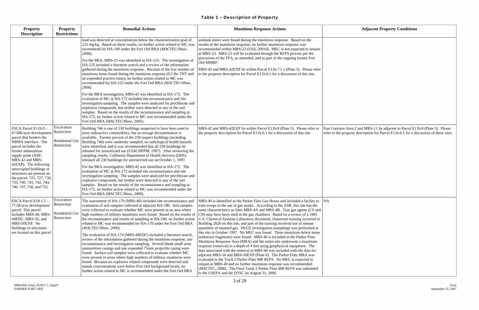
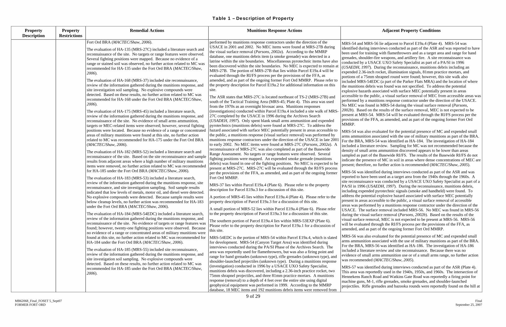
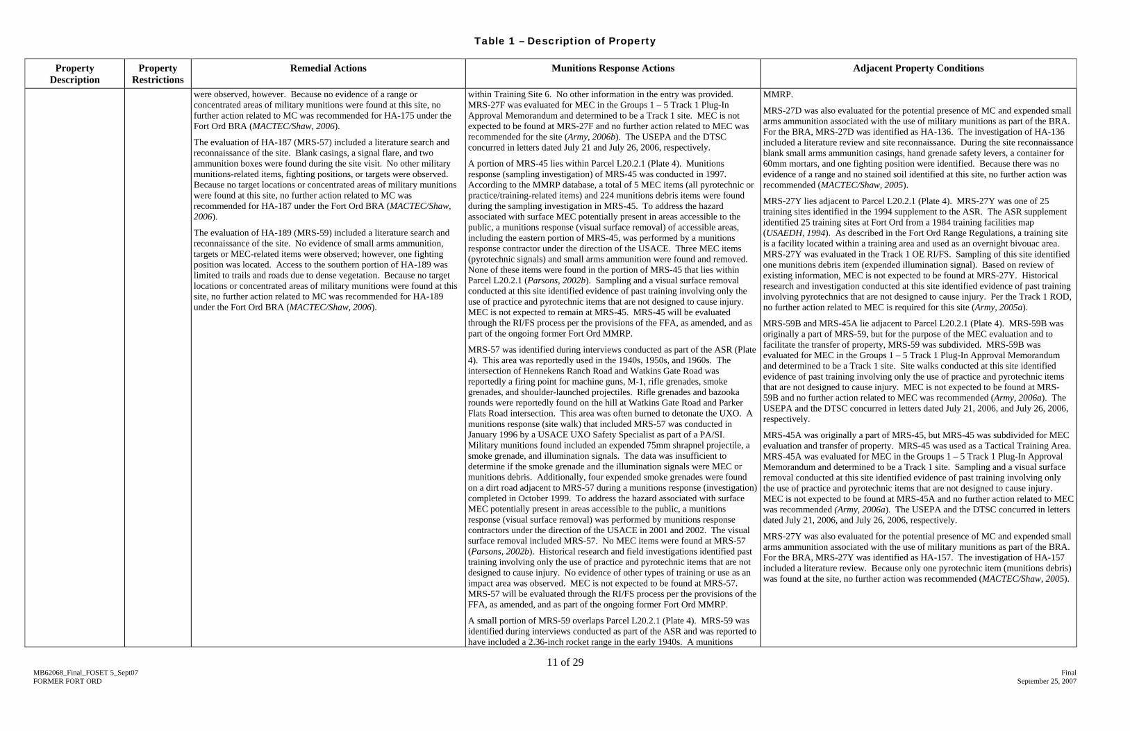
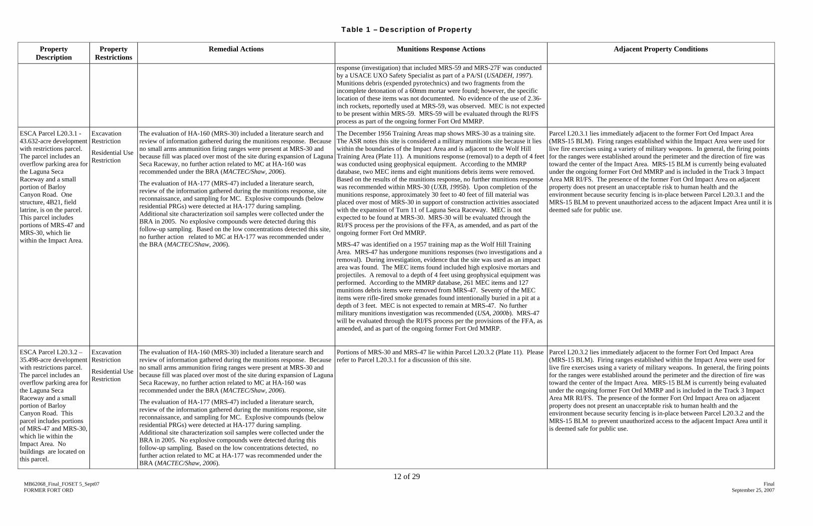
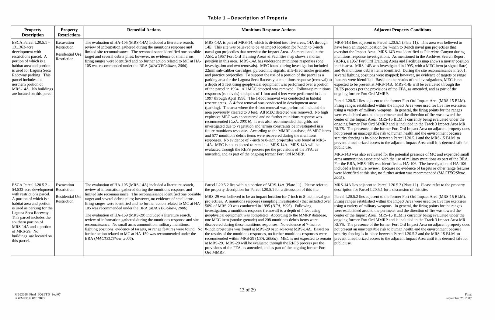
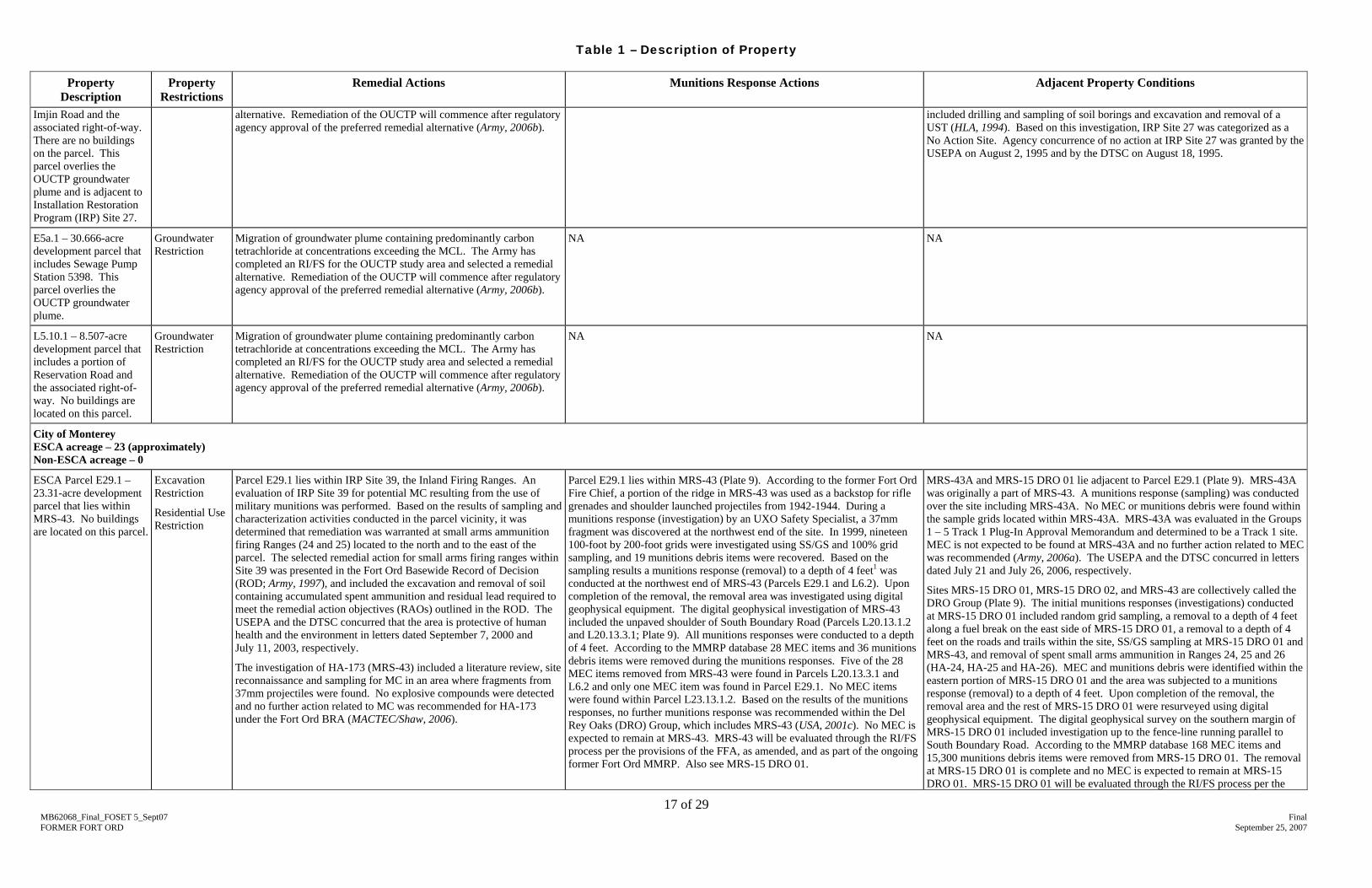
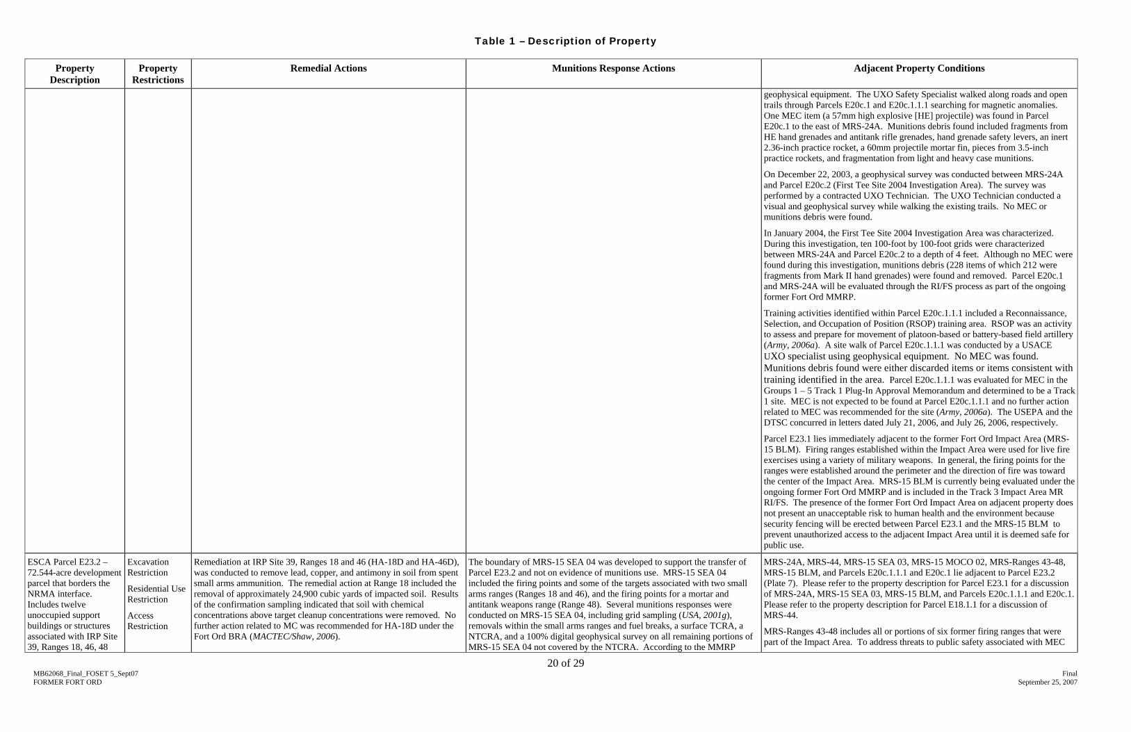
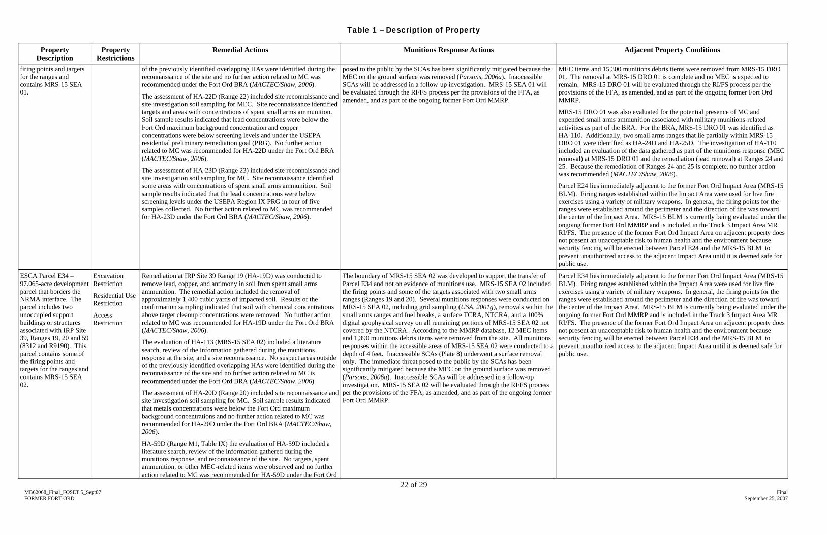
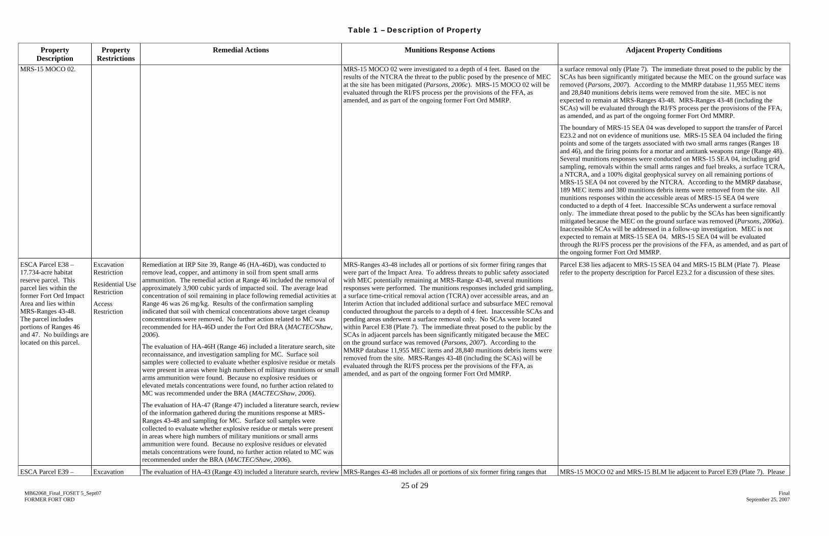
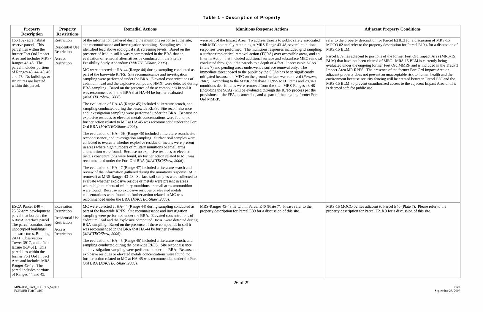
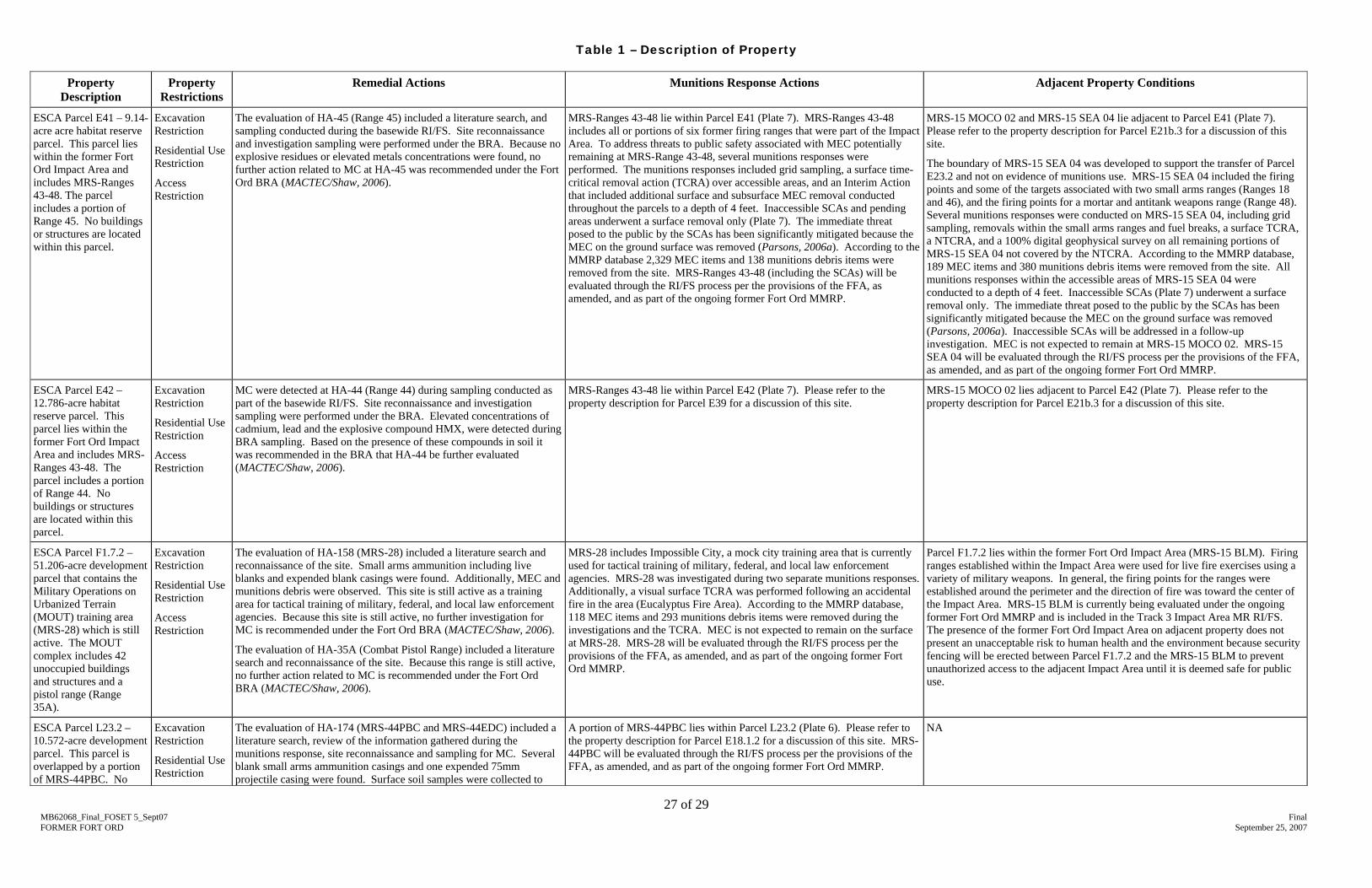
Table 1 – Description of Property (Attachment 3) lists the parcels in this FOSET, and provides brief descriptions of necessary remedial actions and munitions responses that have or will be taken and adjacent property conditions.
5.1. Munitions and Explosives of Concern (MEC)
Based on a review of existing records and available information, there is no evidence that Munitions and Explosives of Concern (MEC) are present on Parcels E4.3.2.2, E4.7.1, E4.7.2, E5a.1 and L5.10.1. (The term “MEC” means military munitions that may pose unique explosives safety risks, including: (A) unexploded ordnance (UXO), as defined in 10 U.S.C., Section 101(e)(5); (B) discarded military munitions (DMM), as defined in 10 U.S.C., Section 2710(e)(2); or (C) munitions constituents (e.g., TNT, RDX), as defined in 10 U.S.C., Section 2710(e)(3), present in high enough concentrations to pose an explosive hazard.) In addition, there is no record of MEC being discovered on the parcels and no record that munitions-related activities occurred.
• Parcel E4.3.2.2 was evaluated for MEC in the Group C Parcels Track 0 Plug-In Approval Memorandum and determined to be Track 01 (Army, 2005b). The USEPA and the DTSC concurred in letters dated July 19, 2005 and July 22, 2005, respectively.
1 Track 0 – areas at the former Fort Ord that contain no evidence of munitions and explosives of concern (MEC) and have never been suspected of having been used for military munitions-related activities of any kind. This definition has been clarified in the Explanation of Significant Differences, Final Record of Decision, No Action Regarding Ordnance-Related Investigations (Track 0 ROD), Former Fort Ord, California (March 2005) to include areas not suspected as having been used for military munitions-related activities of any kind, but where incidental military munitions have been discovered.
MB62068_Final_FOSET 5_Sept07 Final FORMER FORT ORD September 25, 2007
5
• Parcels E4.7.1 and E4.7.2 are portions of Imjin Road and were evaluated for MEC in the Group B Parcels Track 0 Plug-In Approval Memorandum and determined to be Track 0 (Army, 2005c). The USEPA and the DTSC concurred in letters dated June 7, 2005, and June 23, 2005, respectively.
• Parcel E5a.1 is a portion of a parcel previously identified as Parcel E5a (Patton/Abrams Park Housing). Parcel E5a was evaluated for MEC, identified as Track 0, and included in the Track 0 Record of Decision (ROD) (Army, 2002a).
• Parcel L5.10.1 is a portion of a parcel previously identified as Parcel L5.10 (Reservation Road). Parcel L5.10 was evaluated for MEC, identified as Track 0, and included in the Track 0 Record of Decision (ROD) (Army, 2002a).
Based on a review of existing records and available information, there is evidence that MEC are or may be present on Parcels E11b.6.1, E11b.7.1.1, E11b.8, E18.1.1, E18.1.2, E18.1.3, E18.4, E19a.1, E19a.2, E19a.3, E19a.4, E19a.5, E20c.2, E21b.3, E23.1, E23.2, E24, E29.1, E34, E38, E39, E40, E41, E42, F1.7.2, L5.7, L6.2, L20.2.1, L20.3.1, L20.3.2, L20.5.1, L20.5.2, L20.5.3, L20.5.4, L20.8, L20.13.1.2, L20.13.3.1, L20.18, L20.19.1.1, L23.2, L32.1 and S1.3.2. These parcels were previously used, as described below and in Table 4 (Attachment 3), for munitions-related activities that could result in the presence of MEC. Some of these parcels were used for other purposes that should not have resulted in the presence of MEC; however, MEC or munitions debris was discovered there.
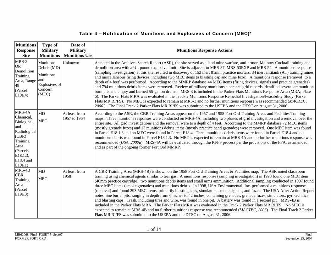
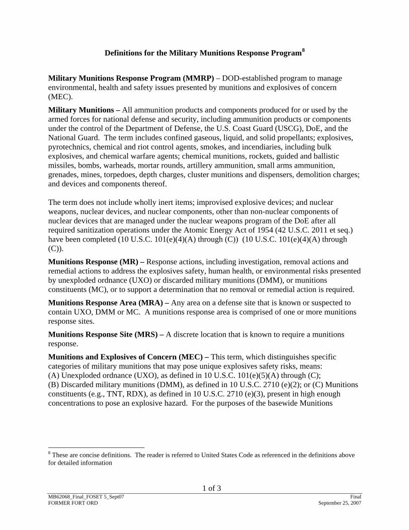
Definitions for terms related to the Fort Ord Military Munitions Response Program (MMRP) are given in Attachment 6.
The Army has performed munitions response actions on portions of the Property pursuant to the Fort Ord Federal Facilities Agreement. The parties agree that known or suspected munitions response sites and detected anomalies that may be MEC will be investigated, analyzed, and managed in accordance with CERCLA and the National Contingency Plan (NCP), with due consideration given to applicable or relevant and appropriate requirements (ARARs).
Per an agreement with USEPA and the DTSC (Army, 2000b), the Army is evaluating military munitions at the former Fort Ord in a basewide Munitions Response Remedial Investigation/Feasibility Study (MR RI/FS), consistent with CERCLA and subject to the provisions of the FFA, as amended. The basewide MR RI/FS is being conducted as part of the Fort Ord MMRP. The MMRP includes the implementation and documentation of munitions responses at MRSs. The basewide MR RI/FS process reviews and evaluates past investigative and removal actions, and makes recommendations for future response actions deemed necessary to protect human health and the environment on the basis of the intended reuse of the Property.
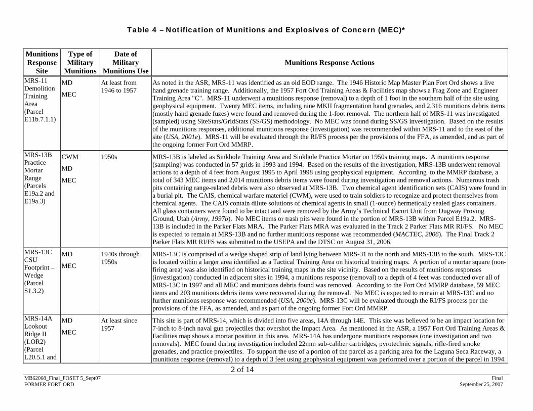
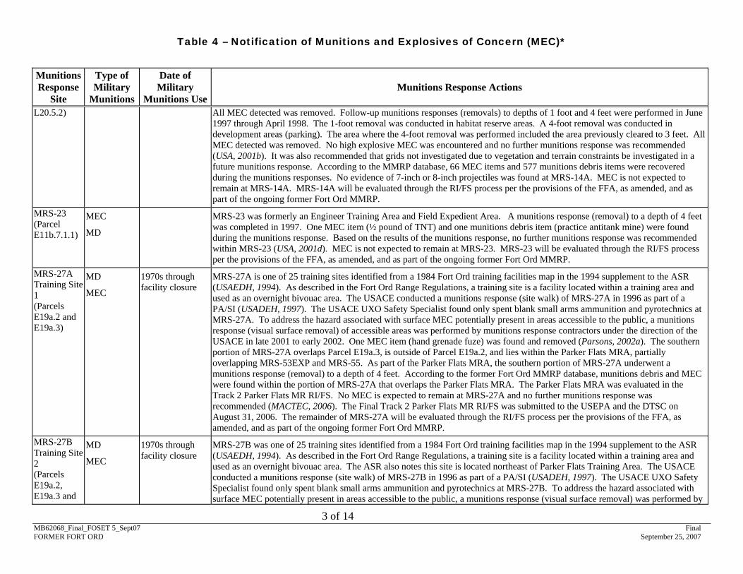
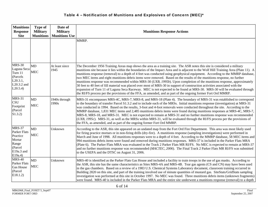
The MRSs on the Property are listed below. Also listed are locations where MEC or munitions debris were found, but there was no evidence that munitions-related activities occurred at these locations. Descriptions of MRSs and munitions response actions are provided in Table 4 – Notification of MEC (Attachment 3).
MB62068_Final_FOSET 5_Sept07 Final FORMER FORT ORD September 25, 2007
6
• Parcel E11b.6.1 (Plate 5): Although no MRSs fall within this parcel, the parcel does lie within an area that was used as an infantry training and maneuver area. Additionally, four MRSs (MRS-11, MRS-42, MRS-48, and MRS-59) are adjacent to the parcel. Parcel E11b.6.1 is part of East Garrison Area 4 (EGA4) and was included in a site walk conducted by the Army in June 2005 to identify any evidence of military munitions in the area (Parsons, 2006b). The site walk entailed visually searching open, accessible portions of EGA4 while operating geophysical detection instruments to locate subsurface geophysical anomalies. No MEC or munitions debris were found in Parcel E11b.6.1 during the site walk. Parcel E11b.6.1 and the adjacent MRSs will be evaluated through the RI/FS process per the provisions of the FFA as amended, and as part of the ongoing former Fort Ord MMRP.
Munitions response actions found MEC on Parcels E11b.7.1.1, E11b.8, E18.1.1, E18.1.2, E19a.1, E19a.3, E19a.4, E19a.5, E20c.2, E21b.3, E23.1, E23.2, E24, E29.1, E34, E38, E39, E40, E41, E42, F1.7.2, L5.7, L6.2, L20.3.1, L20.3.2, L20.5.1, L20.5.2, L20.8, L20.13.3.1, L23.2, L20.18, and S1.3.2. A summary of MEC discovered on the Property is provided in Table 4 – Notification of Munitions and Explosives of Concern (Attachment 3). The Property is a closed range. Given the Property’s past use, the deed will include the Table 4 – Notification of MEC (Attachment 3) and a MEC Notice (Attachment 5). MEC remaining on the Property may be a hazardous substance.
5.2. Environmental Remediation Sites
There were five hazardous and toxic waste remediation sites located on the Property. A summary of the environmental remediation sites on the Property is as follows:
• Parcels E4.3.2.2, E4.7.1, E4.7.2, E5a.1, and L5.10.1 (Plate 3): Operable Unit Carbon Tetrachloride Plume (OUCTP) – groundwater contamination;
• Parcel E19a.4 (Plate 6): IRP Site 8, Molotov Cocktail Range – soil contamination;
MB62068_Final_FOSET 5_Sept07 Final FORMER FORT ORD September 25, 2007
• Parcel S1.3.2 (Plate 4): IRP Site 39B, Inter-Garrison Site – soil contamination; and
• Parcel E11b.7.1.1 (Plate 5): IRP Site 41, Crescent Bluff Fire Drill Area – soil contamination.
All non-MEC related environmental remediation activities at IRP Sites 8, 39B, and 41 have been completed.
Portions of the Property associated with OUCTP and Site 39 have not been remediated to levels suitable for unrestricted use. The deeds for these portions of the Property will include the following land use restrictions, as applicable: no use of groundwater, no residential use, and no soil disturbance. See the Basewide Remedial Investigation Sites ROD (Army, 1997), the Comprehensive Basewide Range Assessment Report (MACTEC/Shaw, 2006), and the OUCTP Proposed Plan (Army, 2006b) and also see Section 10., Site Maps of the Property (Attachment 1), and Table 1 – Description of Property (Attachment 3) of this FOSET for additional information.
The Army is evaluating the entire former Fort Ord, including IRP Site 39, for the potential presence of chemicals of concern at known or suspected small arms ammunition firing ranges, multi-use ranges, and military munitions training areas under the Basewide Range Assessment (BRA).
• The Property was evaluated for the potential presence of munitions constituents (MC) and expended small arms ammunition associated with the use of small arms ammunition as part of the BRA. With the exception of Parcels E4.3.2.2, E4.7.1, E4.7.2, E5a.1, E11b.6.1, and L5.10.1, the Property lies within or partially within the boundary of a MRS. The results of the BRA are summarized in Table 1 – Description of Property (Attachment 3).
• The results of the BRA are reported in the Comprehensive Basewide Range Assessment Report, which is updated as site evaluations are completed. Additional evaluation of soil conditions at some firing ranges and MRSs will be conducted upon completion of any MEC removal in those areas. The results of these evaluations may identify additional remedial areas.
A summary of the environmental remediation sites is provided in Table 2 – Notification of Hazardous Substance Storage, Release, or Disposal (Attachment 3).
5.3. Storage, Release, or Disposal of Non-Munitions Related Hazardous Substances
There is no evidence that non-munitions related hazardous substances were stored, released, or disposed of on Parcels E11b.6.1, E11b.8, E18.1.2, E18.1.3, E18.4,E19a.1, E19a.2, E19a.3, E19a.5, E21b.3, E29.1, E39, E40, E41, E42, L5.7, L6.2, L20.2.1, L20.3.1, L20.3.2,
MB62068_Final_FOSET 5_Sept07 Final FORMER FORT ORD September 25, 2007
9
L20.5.1, L20.5.2, L20.5.3, L20.5.4, L20.8, L20.13.3.1, L20.13.1.2, L20.18 L20.19.1.1 and L32.1 in excess of the 40 Code of Federal Regulations (CFR) Part 373 reportable quantities.
Hazardous substances were stored for one year or more, released, or disposed of on Parcels E4.3.2.2, E4.7.2, E4.7.1, E5a.1, E11b.7.1.1, E19a.4, E23.1, E23.2, E24, E34, F1.7.2, L5.10.1, and S1.3.2, in excess of reportable quantities specified in 40 CFR Part 373. All hazardous substance storage operations have been terminated on these parcels.
Hazardous substances were released in excess of the 40 CFR 373 reportable quantities at the following sites: OUCTP, OU2 Fort Ord Landfills (SWMU FTO-002), IRP Site 8, IRP Site 39, IRP Site 39B, IRP Site 41, and HA-35A. The release or disposal of these hazardous substances was remediated as part of the IRP at OU2 Fort Ord Landfills (SWMU FTO-002), OU2 groundwater plume, IRP Site 8, portions of IRP Site 39, IRP Site 39B, and IRP Site 41. See Section 5.2 Environmental Remediation Sites for additional information.
The OUCTP underlies Parcels E4.3.2.2, E4.7.1, E4.7.2, E5a.1, and L5.10.1. The Army has completed an RI/FS for the OUCTP study area and identified the preferred remedial alternative (Army, 2006b). Remediation of the OUCTP will commence after regulatory agency approval of the preferred remedial alternative.
The release of hazardous substances at HA-35A (lead and possibly copper and antimony) is associated with an active small arms firing range on Parcel F1.7.2. Future use of this parcel will include the continued use of the range. A summary of the areas in which hazardous substance activities occurred is provided in Table 2 – Notification of Hazardous Substance Storage, Release, or Disposal (Attachment 3).
5.4. Petroleum and Petroleum Products
5.4.1. Underground and Aboveground Storage Tanks (UST/AST)
• Current UST/AST Sites - There are no underground or aboveground petroleum storage tanks (USTs/ASTs) currently on the Property.
• Former UST/AST Sites - There were three underground petroleum storage tanks on Parcel L32.1 (USTs 4493.1, 4493.2, and 4493.3), three underground petroleum storage tanks on Parcel S1.3.2 (USTs 4545.1, 4545.2, and 4545.3), and one underground petroleum storage tank on Parcel E18.1.3 (UST 4387) that were removed.
− There was no evidence of petroleum release from USTs 4493.1 and 4493.2. See the closure letter from the Monterey County Department of Health (MCDOH), dated January 3, 1994, for additional information regarding closure of 4493.2, and the closure letter dated April 6, 1994, for additional information regarding closure of 4493.1.
− Petroleum product releases occurred from UST 4493.3. The release of these petroleum products was remediated as part of UST closure. See the closure letter from the MCDOH, dated August 22, 1996, for additional information.
MB62068_Final_FOSET 5_Sept07 Final FORMER FORT ORD September 25, 2007
10
− There was no evidence of petroleum release from USTs 4545.1 and 4545.3. See the closure letter from the MCDOH dated January 6, 1997, for additional information regarding closure of 4545.1 and 4545.2.
− Petroleum product releases occurred from UST 4545.2. The release of these petroleum products was remediated as part of UST closure. See the closure letter from the MCDOH dated November 6, 1997, for additional information.
− UST 4387 was removed in July 1991. There was no evidence of petroleum release from this site. See the closure letter from the MCDOH, dated January 3, 1994, for additional information.
A summary of the UST petroleum product activities is provided in Table 3 - Notification of Petroleum Products Storage, Release, or Disposal (Attachment 3).
5.4.2. Non-UST/AST Storage, Release, or Disposal of Petroleum Products
There is no evidence that non-UST/AST petroleum products in excess of 55 gallons were stored for one year or more on the Property.
5.5. Polychlorinated Biphenyls (PCB)
There is no evidence that PCB-containing equipment is located, or was previously located, on the Property (Weston, 1990).
5.6. Asbestos
There is non-friable asbestos containing material (ACM) in the following buildings: 2A41, 4A22, 4A35, 4A49, 4B13, 4B21, 4B38, 4B50, 4B52, 4B65, 414, 417, 456, 725, 727, 730, 735, 742, 744, 747, 750, 752, 3908, 3917, 3941, 3983, 4386, 4387, 4545, 6275, 6277, 6281, 6282, 8301, 8301A, R9180, R9190, R9230, R9451, R9463, and R9483.
The ACM includes roof penetration mastic, roof flashing mastic, sealant/mastic, roofing cap sheet, roofing mastic, window putty, joint compound, resilient sheet flooring, resilient floor tile, mastic, felt paper, floor tile mastic, textured paint, floor mastic, roof flashing, and transite sheet material. No friable ACM was found in these buildings.
This information is summarized in Table 5 (Attachment 3). See the Fort Ord Asbestos Survey Report (DEI, 1993) for additional information.
The deeds will include an asbestos warning and covenant (Attachment 5).
5.7. Lead-Based Paint (LBP)
The following buildings on the Property are known or presumed to contain LBP: 2A41, 4A18, 4A22, 4A29, 4A30, 4A34, 4A35, 4A44, 4A49, 4A52, 4A60, 4A64, 4B21, 4B38, 4B50, 4B56, 4B65, 4B74, 4B77, 610, 624A, 632, 633, 826, 829, 3917, 3908, 3939, 3941, 3949, 3949A, 3949B, 3983, 3991, 3953B, 4386, 4387, 4475, 4545, 8302, 8304, 8312, R391, and R392.
MB62068_Final_FOSET 5_Sept07 Final FORMER FORT ORD September 25, 2007
11
The dates of construction for the following buildings are unknown; therefore, it is presumed LBP may be present at these building as well: 4B13, 4B52, 8301A, 8301B, R9221, and R9232. The buildings listed above were not used for residential purposes and the transferee does not intend to use these buildings for residential purposes in the future.
The deeds will include a lead-based paint warning and covenant (Attachment 5).
5.8. Radiological Materials
Building 746 was suspected to have been used for radiological activities in the past, but radiological use is not documented. There is no evidence of any release of radiological materials at this building.
Building 746 was among the twenty percent of 230 suspect buildings at the former Fort Ord that were randomly sampled. No radiological health hazards were identified for the twenty percent sampled, and a recommendation was made that all 230 suspect buildings be released for unrestricted use (USACHPPM, 1997).
The California Department of Health Services (DHS) released all buildings with documented or suspected use or storage of radioactive commodities (including Building 746) for unrestricted use (DHS, 1997). See Industrial Radiation Survey No. 27-43-E2HU-3-94, Facility Close-Out and Termination Study, Fort Ord, California (January 10, 1994 – April 15, 1994) for additional information.
5.9. Radon
There were no radon surveys conducted on the Property; however, radon surveys were conducted in approximately 2,900 buildings at the former Fort Ord in 1989 and 1990 and radon was not detected at or above the USEPA residential action level of 4 picocuries per liter (pCi/L).
5.10. Installation-Wide Multispecies Habitat Management Plan
Parcels in this FOSET are designated under the Installation-Wide Multispecies Habitat Management Plan (HMP):
• Development with Reserve Areas or Development with Restrictions – L20.3.1, L20.3.2, L20.5.1, L20.5.2, and L20.5.3.
• Borderland Development Areas along Natural Resources Management Area (NRMA) Interface – E11b.8, E19a.3, E19a.5, E21b.3, E23.1, E23.2, E24, E34, E40, L5.7, L20.19.1.1, and S1.3.2.
MB62068_Final_FOSET 5_Sept07 Final FORMER FORT ORD September 25, 2007
The resource conservation and management requirements for these HMP categories are described in the April 1997 HMP and in the Assessment East Garrison – Parker Flats Land Use Modifications, Fort Ord California, dated May 1, 2002.
The parcels identified as HMP Development Parcels have no HMP resource conservation or management requirements; however, the HMP does not exempt the Grantee from complying with environmental regulations enforced by Federal, state, or local agencies. CERCLA remedial actions undertaken by the Grantee will be conducted in accordance with the Army’s requirements identified in the HMP, Chapter 3, and in the existing Biological Opinions.
Reuse activities conducted by the Grantee, not including CERCLA actions, are not exempt from complying with environmental regulations enforced by Federal, state, or local agencies. These regulations may require the Grantee to obtain permits from the U.S. Fish and Wildlife Service (USFWS) as required by the Endangered Species Act (ESA); complying with prohibitions against the removal of listed plants occurring on Federal land or the destruction of listed plants in violation of any State laws; complying with measures for conservation of State-listed threatened and endangered species and other special-status species recognized by the California ESA, or California Environmental Quality Act (CEQA); and complying with local land use regulations and restrictions.
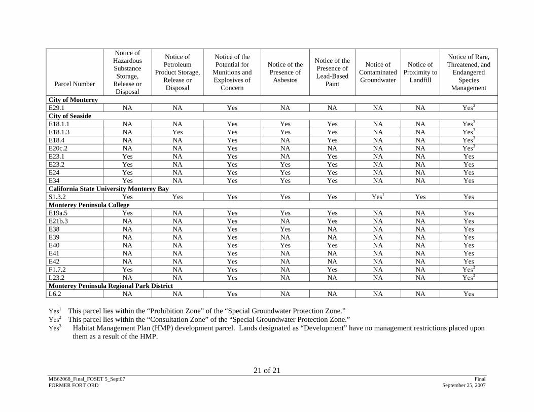
The deeds will include the “Notice of The Presence of Threatened and Endangered Species” provided in the Environmental Protection Provisions (Attachment 5).
5.11. Other Property Conditions
There are no other hazardous conditions on the Property that present an unacceptable risk to human health and the environment. Clean Air Act General Conformity Rule requirements for this transfer were satisfied by a Record of Non-Applicability based upon an exemption for property transfers or leases where the proposed action will be a transfer of ownership, interest and title in the land, facilities, and associated real and personal property as soon as it meets the requirements under CERCLA.
6. ADJACENT PROPERTY CONDITIONS
Other potentially hazardous conditions existing on adjacent property are summarized in Table 1 – Description of Property (Attachment 3). As described in Table 1, the presence of these hazards on adjacent property does not present an unacceptable risk to human health and the environment.
7. ENVIRONMENTAL REMEDIATION AGREEMENTS
The following environmental remediation orders and agreements are applicable to the Property: The Fort Ord MR RI/FS, the Fort Ord Installation-Wide Multispecies HMP, three Fort 3 Habitat Corridor parcel with “Borderland Requirements.”
MB62068_Final_FOSET 5_Sept07 Final FORMER FORT ORD September 25, 2007
13
Ord-specific Biological Opinions (1-8-99-F/C-39R; 1-8-01-F-70R; and 1-8-04-F-25R), and the FFA, effective November 19, 1990. Some, but not all, remediation activities on the Property required by the FFA are completed or in place and operating properly and successfully (OPS). The CERCLA Notice, Assurances, Warranty, and Access Provisions and other Deed Provisions (Attachment 4), EPPs (Attachment 5) and deeds will include provisions reserving the Army’s right to conduct remediation activities and the regulators’ right of access.
8. REGULATORY/PUBLIC COORDINATION
The USEPA Region 9, the DTSC, and the public were notified of the initiation of this FOSET. The 30-day public review period was from June 28, 2007 to July 28, 2007. At the request of members of the public, the public review period was extended through August 13, 2007. Regulatory and public comments received during the public comment period were reviewed and incorporated, as appropriate. A copy of regulatory and public comments and the Army Response are included in Attachments 7 and 8, respectively.
9. NATIONAL ENVIRONMENTAL POLICY ACT (NEPA) COMPLIANCE
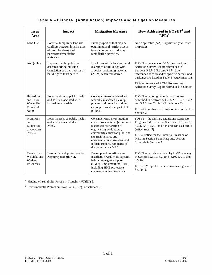
The environmental impacts associated with the proposed transfer of the Property have been analyzed in accordance with the National Environmental Policy Act (NEPA). The results of this analysis are documented in the Final Environmental Impact Statement Fort Ord Disposal And Reuse (June 1993), associated Record of Decision (December 1993), Supplemental Environmental Impact Statement Fort Ord Disposal and Reuse (June 1996) and associated Record of Decision (June 1997). Encumbrances4 identified in the NEPA analysis as necessary to protect human health or the environment are summarized in Table 6 – Disposal (Army Action) Impacts and Mitigation Measures (Attachment 3).
10. LAND USE CONTROLS
10.1. Deed Restrictions and Notifications
The environmental documents listed in Attachment 2 were evaluated to identify environmental factors that may warrant constraints on certain activities to ensure protection of human health and the environment. Such constraints are generally embodied as restrictions in the deed, or as specific notifications in the deed or other documents supporting the transaction, and will be effective upon transfer of the Property. The factors that require either deed restrictions or specific notifications are identified in Attachment 5 (EPPs). These restrictions will be in effect until the deed provisions are terminated, removed, or modified as specified in an appropriate CERCLA decision document and protectiveness of human health and the environment can be assured by the modified restrictions or additional restrictions, if necessary.
The relevant portions of this FOSET and the EPPs will be referred to in the deeds for transfer of this Property, as a description of the ongoing remedial actions to be taken with regard to any hazardous substances stored for more than one year, or known to have been released, or disposed of as required by CERCLA 120(h). Notification of hazardous substance storage,
4 For the purposes of the FOSET, “encumbrances” include mitigations (to be implemented by the Army) necessary to protect human health and the environment from impacts associated with the disposal of property at the former Fort Ord.
MB62068_Final_FOSET 5_Sept07 Final FORMER FORT ORD September 25, 2007
14
release, or disposal on the Property shall be provided in the transfer documents, as required under CERCLA 120(h).
10.2. Covenants to Restrict Use of Property – Environmental Restrictions
To further ensure protection of human health and the environment, the Army has agreed to enter into Covenants to Restrict Use of Property (CRUPs) with the State of California. The CRUPs will place additional use restrictions on all of the transferring property, as appropriate, and will be signed prior to transfer. The Army and the DTSC agree that the use of the Property will be restricted as set forth in the CRUPs. The restrictions and factors that require these CRUPs are described below. These restrictions will also be described in the CRUPs and will be in effect until terminated, removed, or modified, as specified in an appropriate CERCLA decision document, and protectiveness of human health and the environment can be assured by the modified restrictions or additional restrictions, if necessary. See Table 1 – Description of Property (Attachment 3) and the Environment Protection Provisions (Attachment 5) for additional information.
• Soil Disturbance: Due to the former use of the Property as a military installation, the Property may contain MEC and there remains a risk of encountering subsurface MEC; therefore, any person conducting ground disturbing or intrusive activities (e.g., digging or drilling) must comply with the applicable municipal code (see Section 10.3). Any alterations, additions, or improvements to the Property in any way that may violate excavation restrictions, as defined in the applicable municipal code, are prohibited. No actual or potential hazard exists on the surface of the Property from MEC that may be in the subsurface of the Property provided the parties adhere to the restrictions of the CRUP.
• Residential Use:
− The Army and DTSC have agreed to enter into a CRUP to restrict the residential use of portions of the Property. The USEPA also believes any proposals for the residential reuse of these portions of the Property should be subject to regulatory review.
− The Army has completed remedial actions for MC (lead) in soil on portions of the Property; however, a Post-Remediation Risk Assessment (PRRA) must be performed to evaluate potential human health risks and hazards associated with exposure to residual MC (lead) remaining in soil. Until such time the PRRA is complete and concludes impacts on human health are unlikely, and the USEPA and the DTSC concur with such conclusions, the Property will be restricted from residential use. For purposes of this provision, residential use includes, but is not limited to single family or multi-family residences; child care facilities; nursing homes or assisted living facilities; and any type of educational purpose for children or young adults in grades kindergarten through 12. Provided the restrictions of the CRUP are adhered to, no actual or potential hazard exists on the Property from MC in soil on the Property.
MB62068_Final_FOSET 5_Sept07 Final FORMER FORT ORD September 25, 2007
15
• Special Case Areas: Portions of the Property lie within the historical boundaries of the Impact Area of the former Fort Ord. The Army has performed munitions responses on these portions of the Property; however, Special Case Areas (SCAs)5 remain and access to these parcels with remaining SCAs by unaupersonnel is prohibited.
thorized
• Access to the Impact Area: Portions of the Property lie within the historical boundaries of the Impact Area of the former Fort Ord. The Army has performed munitions responses on these portions of the Property; however, the Army has not completed munitions responses in the adjacent portions of the Impact Area that are not part of the Property. Therefore, access to the Impact Area adjacent to the Property is prohibited.
• Special Groundwater Protection Zone: A portion of the former Fort Ord lies within a “Special Groundwater Protection Zone” as defined by Monterey County Ordinance 04011. Use of groundwater is prohibited on portions of the Property as described in the CRUPs. Provided the restrictions of the CRUP are adhered to, no actual or potential hazard exists on the surface of the Property from groundwater contamination or from possible soil gas volatilization resulting from groundwater contamination underlying the Property.
10.3. Municipal Code
Pursuant to agreements with the DTSC, the County of Monterey, the City of Del Rey Oaks, the City of Marina, the City of Monterey, and the City of Seaside have adopted municipal code provisions6 that address potential UXO risk by requiring permits for certain ground disturbing or intrusive activities. The County of Monterey, the City of Del Rey Oaks, the City of Marina, the City of Monterey, and the City of Seaside have designated all real property within their respective land use jurisdictions that was formerly part of Fort Ord and was identified as the possible location of UXO as “Ordnance Remediation Districts.”
10.4. School Properties
Should this Property be considered for the proposed acquisition and/or construction of school properties using State funding, a separate environmental review process in compliance with the California Education Code 17210 et. seq. will need to be completed and approved by the DTSC.
5 Special Case Areas (SCAs) are areas in the MRS in which MEC removal cannot be completed within the scope of work due to metallic clutter or obstructions that compromise instrument performance or technician safety or because the removal process would cause a serious adverse impact to the habitat. SCAs are shown on Plates 7 and 8 (Attachment 1). The specific types of SCAs depend on the conditions at specific MRSs and are listed in Table 1 (Attachment 3), Table 4 (Attachment 3) and Attachment 6. 6 Monterey County Code – Chapter 16.10, City of Del Rey Oaks Municipal Code – Chapter 15.48, City of Marina Municipal Code – Chapter 15.56, City of Monterey City Code – Chapter 9, Article 8, City of Seaside Municipal Code – Chapter 15.34.
MB62068_Final_FOSET 5_Sept07 Final FORMER FORT ORD September 25, 2007
16
11. ANALYSIS OF INTENDED LAND USE AND RISK ASSESSMENT RESULTS
During the deferral period, FORA will complete remedial actions for the ESCA parcels, and the Army will complete remedial actions for the non-ESCA parcels. During this time, the parcels will be restricted from use except as described below. More than one condition, remedial or mitigating action, risk assessment, or LUC may apply to a given parcel; therefore, parcels may be listed more than once in this section.
• Parcels E11b.6.1, E11b.7.1.1, E11b.8, E18.1.3, E18.4, E19a.2, E20c.2, E21b.3, E23.1, E23.2, E24, E29.1, E34, E38, E39, E40, E41, E42, F1.7.2, L5.7, L6.2, L20.2.1, L20.3.1, L20.3.2, L20.5.1, L20.5.2, L20.5.3, L20.5.4, L20.8, L20.13.1.2, L20.13.3.1, L20.18, L20.19.1.1, L23.2, and S1.3.2 and portions of Parcels E18.1.1, E18.1.2, E19a.1, E19a.3, and E19a.4: These parcels of the Property include all or portions of several MRSs and have been evaluated for the presence of MEC (see Attachment 1, Site Maps of the Property and Attachment 3, Table 1 and Table 4). These evaluations have included one or more of the following investigation types conducted on the portion of these parcels that includes a MRS: site reconnaissance and subsurface MEC investigation and/or removal actions.
The evaluation of those portions of the parcels lying outside of the boundary of an MRS included a literature review, and in some cases, a surface removal completed within the accessible areas of the parcel. MEC is not expected to remain on the surface at these parcels. In accordance with the ESCA, the AOC, and the FFA, as amended, FORA will complete remedial and corrective actions, which will include an evaluation of the risk associated with MEC potentially remaining at associated MRSs, during the deferral period for these parcels. Until such remedial and corrective actions are complete, the following LUCs will be implemented by the FORA to address risk: Deed and/or Zoning Restrictions; MEC Recognition and Safety Training; Construction Monitoring; and Access Management Measures.
Upon regulatory closure of MRSs on these portions of the Property, the Army will execute and deliver the CERCLA Warranty to FORA, at which time the Property is intended for a variety of uses, including park facilities, roads and road improvements, education facilities, habitat management, a cemetery, residential, commercial, equestrian facilities, and other mixed use and development. In accordance with the ESCA, the AOC and the FFA, as amended, development for some of these uses may occur in conjunction with remedial and corrective actions.
• Parcels E18.1.3, E18.4, E19a.2, E20c.2, E21b.3, E29.1, E38, L6.2, L20.3.1, L20.3.2, L20.5.1, L20.5.2, L20.5.3, L20.5.4, L20.8, L20.13.1.2, L20.13.3.1, L20.18, L23.2, and S1.3.2: The Army has performed munitions responses at these parcels. The CERCLA response actions at these parcels have not been completed because the parcels and/or associated MRSs must still be evaluated through the MR RI/FS process and, based on the results of the munitions responses associated with these parcels, a preferred remedial alternative selected in a CERCLA decision document; however, it is reasonably expected that exposure to MEC is unlikely (see Attachment 3, Table 1 and Table 4).
MB62068_Final_FOSET 5_Sept07 Final FORMER FORT ORD September 25, 2007
17
• Parcels E11b.6.1, E11b.7.1.1, E11b.8, E18.1.1, E18.1.2, E19a.1, E19a.3, E19a.4, F1.7.2, L5.7, L20.19.1.1, and L20.2.1: These parcels were evaluated for the presence of MEC through one or more of the following investigations: site reconnaissance, MEC investigation, and in some cases a removal action. For the portions of parcels outside of a MRS, a surface removal was completed within the accessible areas of the parcel. MEC is not expected to be present on the surface at these parcels. An evaluation of the risk associated with MEC potentially remaining on these parcels will be addressed as part of the remedial and corrective actions by the FORA during the covenant deferral period. These parcels will be evaluated through the RI/FS process per the provisions of the FFA as amended, and as part of the ongoing MMRP. Until such remedial and corrective actions are complete, the following interim LUCs will be implemented by the FORA to address risk: Deed and/or Zoning Restrictions; MEC recognition and Safety Training; Construction Monitoring; and Access Management Measures.
• Parcels E23.1, E23.2, E24, E34, E39, E40, E41, and E42: The Army has performed munitions responses on these parcels; however, these parcels include SCAs (Attachment 1, Plates 7 and 8). The immediate threat posed to the public by the SCAs has been significantly mitigated because the MEC on the ground surface was removed (Attachment 3, Table 1 and Table 4); however, these SCAs require additional investigation under the MR RI/FS per the provisions of the FFA, as amended. Until such remedial and corrective actions are complete, the following LUCs will be implemented by the FORA to address risk: Deed and/or Zoning Restrictions; MEC recognition and Safety Training; Construction Monitoring; and Access Management Measures.
• Parcels E19a.5 and L32.1 and portions of Parcels E18.1.1, E18.1.2, E19a.1, E19a.3, and E19a.4: These parcels include all or portions of thirteen MRSs (MRS-3, MRS-4B, MRS-13B, MRS-27A, MRS-27B, MRS-27G, MRS-37, MRS-40, MRS-50/50EXP, MRS-52, MRS-53/53EXP, MRS-44EDC, and MRS-55) that comprise the Parker Flats MRA (Attachment 1, Plate 6). MEC removal actions were completed throughout the Parker Flats MRA to a depth of 4 feet below ground surface (bgs). In addition, if anomalies were detected at depths greater than 4 feet bgs, the anomalies were investigated and MEC was removed if found.
The results of the risk assessment for the Parker Flats MRA reuse areas indicated that the completed MEC investigation and removal actions decreased the overall risk associated with MEC for the majority of the reuse-specific receptors evaluated. For the majority of the reuse receptors, overall MEC risk scores were estimated as low to lowest. For the remaining receptors, overall MEC risk scores were estimated as high or the highest only for those receptors that were assumed to perform intrusive activities, such as hand digging and excavation.
The Army has completed the MR RI/FS process for the Parker Flats MRA and has identified LUCs as the preferred remedial alternative. The final decision for selection of the preferred remedial alternative will be made after soliciting and considering public comments and will be documented in a Record of Decision
MB62068_Final_FOSET 5_Sept07 Final FORMER FORT ORD September 25, 2007
18
(ROD), which is expected to be completed in mid-2007. In the interim, the following LUCs will be applied to the parcels to mitigate and manage potentially remaining MEC risks at the Parker Flats MRA reuse areas: Deed and/or Zoning Restrictions; MEC Recognition and Safety Training; Construction Monitoring; and Access Management Measures.
• Parcel F1.7.2: This parcel includes the Military Operations on Urbanized Terrain (MOUT) training area, which was previously used for tactical training of military, federal, and local law enforcement agencies. The intended land use for the MOUT is as a police and anti-terrorist training area as part of the Monterey Peninsula College (MPC) Public Safety Training Program. Through prior arrangement with the MPC, the MOUT will continue to be used as a tactical training facility by military, federal, and local law enforcement agencies on a periodic basis. Based on the results of munitions responses (Attachment 3, Table 4, MRS-28), the Army has determined additional investigations at the MOUT under the MR RI/FS are necessary. These investigations will be performed by the FORA through the ESCA; however, the Army has also determined the intended land use as a police and anti-terrorist training area is protective of human health and the environment with the implementation of the LUCs specified for Parcel F1.7.2 in the EPPs (Attachment 5).
• Parcels L20.3.1, L20.3.2, L20.5.1, L20.5.2, and L20.5.4: These parcels include areas used for parking, staging and on-site portable/temporary toilets for events associated with the Mazda Raceway Laguna Seca. This is the intended land use for these parcels. Based on the results of munitions responses (Attachment 3, Table 4, MRS-14A, MRS-29, MRS-30, and MRS-47), the Army has determined additional investigations under the MR RI/FS are necessary. These investigations will be performed by the FORA through the ESCA; however, the Army has also determined the intended land use as area for parking, staging and on-site portable/temporary toilets for events associated with the Mazda Raceway Laguna Seca is protective of human health and the environment with the implementation of the LUCs specified for Parcels L20.3.1, L20.3.2, L20.5.1, L20.5.2, and L20.5.4 in the EPPs (Attachment 5).
• Parcels L20.8 and L20.19.1.1: These parcels include portions of Barloy Canyon Road, which is used for access to events associated with the Mazda Raceway Laguna Seca. This is the intended land use for these parcels. Based on the results of munitions responses (Attachment 3, Table 4, MRS-11, MRS-27O, MRS-42EXP, and MRS-48), the Army has determined additional investigations under the MR RI/FS are necessary. These investigations will be performed by the FORA through the ESCA; however, the Army has also determined the intended land use as an access route for events associated with the Mazda Raceway Laguna Seca is protective of human health and the environment with the implementation of the LUCs specified for Parcels L20.8 and L20.19.1.1 in the EPPs (Attachment 5).
• Parcels E11b.7.1.1, E19a.4, and S1.3.2: These parcels include Installation Restoration Program (IRP) Sites 41, 8, and 39B, respectively. Interim Actions (IAs) were conducted at these IRP Sites under the Fort Ord Basewide RI/FS to remove
MB62068_Final_FOSET 5_Sept07 Final FORMER FORT ORD September 25, 2007
19
concentrations of chemicals that were above target cleanup concentrations (TCCs) identified during site characterization. Results of the confirmation sampling indicated soil with concentrations of chemicals above TCCs were removed and results of the subsequent risk evaluation indicate no further threat to human health, the environment, or groundwater is anticipated and no further investigation or remediation was recommended for these IRP Sites. The USEPA concurred that no further action was necessary at IRP Sites 8 and 41 in a letter dated April 14, 1997, and that no further action was necessary at Site 39B in a letter dated January 13, 1998. The DTSC concurred that no further action was necessary at IRP Site 41 in a letter dated March 10, 2006 and that no further action was necessary at IRP Sites 8 and 39B in letters dated October 20, 2006. Based on this information, no LUCs are required for these parcels to address soil contamination.
• Parcels E4.3.2.2, E4.7.1, E4.7.2, E5a.1, and L5.10.1 (non-ESCA): These parcels are not associated with MRSs and are intended to be transferred for a variety of uses, including roads and road improvements, habitat management, residential, and other mixed use and development.
These parcels overlie the OUCTP. The Army has completed a RI/FS for the OUCTP study area and identified the preferred remedial alternative (Army 2006b). Remediation of the OUCTP will commence after regulatory agency approval of the preferred remedial alternative. Risk related to exposure of onsite residents to contamination present in the OUCTP was evaluated in the final OUCTP RI/FS (MACTEC, 2006a). The results of the Human Health Risk Assessment (HHRA) for OUCTP indicate there is a potential cancer risk for a future onsite resident that uses untreated groundwater from OUCTP for drinking and household water purposes; however, groundwater from OUCTP is not currently supplied for domestic use. “Exposure control” is achieved for OUCTP in that the installation of water wells at the former Fort Ord is restricted under Monterey County Ordinance No. 04011. Therefore, the estimated cancer risks are based on a hypothetical “worst-case” scenario under which an individual installs a private drinking water well without authority, permit, or approval, and uses it exclusively for their drinking and household water purposes.
Cancer risks were estimated for two different scenarios and were compared to regulatory risk management values. A hypothetical on-site resident represents the most conservative exposure scenario evaluated. For the reasonable maximum exposure (RME) scenario, it was assumed that an onsite resident would be exposed to VOCs through domestic use of groundwater and from vapor intrusion to indoor air from soil gas and groundwater 350 days per year for a total duration of 30 years (both during childhood and as an adult). Contamination in the A-Aquifer was associated with the highest estimated cancer risk from all pathways (3 in 100,000); followed by the Upper 180-Foot Aquifer 2 in 100,000); and then the Lower 180-Foot Aquifer (2 in 100,000). The estimated excess cancer risk from direct contact with groundwater was 1 in 100,000 in the A-aquifer; 3 in 1,000,000 in the Upper 180-Foot Aquifer; and 2 in 1,000,000 in the Lower 180-Foot Aquifer. These cumulative excess cancer risk estimates for exposure to contaminants in groundwater are within
MB62068_Final_FOSET 5_Sept07 Final FORMER FORT ORD September 25, 2007
20
the USEPA and DTSC cancer risk management range of “1 in 10,000” to “1 in 1,000,000,” and are above the DTSC’s point of departure for risk management of “1 in 1,000,000”.
Non-cancer risks were estimated for two different scenarios and were compared to regulatory risk management values. For the RME scenario, it was assumed that an onsite resident would be exposed to VOCs through domestic use of groundwater and from vapor intrusion to indoor air from soil gas and groundwater 350 days per year for a total duration of 30 years (both during childhood and as an adult). The total RME hazards estimated for the three aquifers for the adult resident and child resident did not exceed the regulatory hazard index of one (1.0). The cumulative non-cancer hazard estimates are below the acceptable non-cancer regulatory hazard index of 1.0 for both exposure scenarios and all three groundwater remedial units.
The following LUCs will be applied to the parcels to mitigate and manage potential risks from VOCs in groundwater at the OUCTP: Deed Restrictions; Local Ordinances; and CRUPs. These LUCs are described in the EPPs (Attachment 5).
• Parcel E4.3.2.2 (non-ESCA): This parcel is adjacent to the Operable Unit 2 (OU2) groundwater plume. The intended use of Parcel E4.3.2.2 is residential, the same as its current use. Risk related to the exposure of onsite residents to contamination present in the OU2 groundwater plume was evaluated in the Baseline Risk Assessment as part of the Remedial Investigation of the OU2 Fort Ord Landfills (Dames and Moore, 1993). The results of the risk assessment determined volatile organic compounds (VOCs), if not addressed by the selected remedy (placement of an engineered cover system over the landfill, groundwater extraction/treatment and institutional controls), might present a potential threat to public health, welfare, or the environment. A ROD was signed in 1994 by the USEPA, DTSC, and the Regional Water Quality Control Board (RWQCB) where it was agreed that the selected remedy is protective of human health and the environment (Army, 1994). The USEPA concurred in a letter dated January 4, 1996 that the OU2 groundwater treatment system is operating properly and successfully. Groundwater from the OU2 groundwater plume is not supplied for domestic use, and the installation of new water wells at the former Fort Ord is restricted under Monterey County Ordinance No. 04011 and Marina Municipal Code Chapter 13.12. The following LUCs will be applied to the parcel to mitigate and manage potential risks from VOCs in groundwater at OU2: Deed Restrictions; Local Ordinances; and CRUPs. These LUCs are described in the EPPs (Attachment 5).
12. FINDING OF SUITABILITY FOR EARLY TRANSFER
Based on the above information, I conclude that all DOD requirements to reach a finding of suitability for early transfer of the Property to the FORA have been met for the Early Transfer Property. The proposed use of the Early Transfer Property by the transferee for the uses identified herein is consistent with protection of human health and the environment, subject to (a) inclusion of and compliance with the covenants required by the AOC between the FORA, the USEPA, and the DTSC; and (b) the restrictions, covenants, and notifications in this document. In addition, the terms and conditions set forth in the attached CERCLA Notice, Assurances,
MB62068_Final_FOSET 5_Sept07 Final FORMER FORT ORD September 25, 2007
21
ATTACHMENT 1
SITE MAPS OF THE PROPERTY
ATTACHMENT 2
ENVIRONMENTAL DOCUMENTATION
1 of 7 MB62068_Final_FOSET 5_Sept07 Final FORMER FORT ORD September 25, 2007
ENVIRONMENTAL DOCUMENTATION7
Arthur D. Little, Inc. (ADL), 1994. Final Community Environmental Response Facilitation Act (CERFA) Report, Fort Ord, Monterey, California. April.
California Department of Health Services (DHS), 1997. Memorandum documenting that with respect to radiological issues, the buildings listed in the memorandum are acceptable for unrestricted release. October 1.
Dames & Moore, 1993. Baseline Risk Assessment, Remedial Investigation/Feasibility Study, Site 2 Landfills, Fort Ord, California. June 7.
Department of the Army, 1993. Fort Ord, California Disposal and Reuse Environmental Impact Statement, Record of Decision. December 23.
_____, 1994. Record of Decision Operable Unit 2, Fort Ord Landfills, Fort Ord, California. July 15.
_____, 1996. Final Supplemental Environmental Impact Statement Fort Ord Disposal and Reuse. June.
_____, 1997. Record of Decision, Fort Ord, California, Disposal and Reuse Supplemental Environmental Impact Statement. June 18.
Diagnostic Environmental, Inc., 1993. Asbestos Survey Report U.S. Army Corps of Engineers, Fort Ord Installation, Fort Ord, California. April 26.
Federal Facility Agreement (FFA), 1990. United States Environmental Protection Agency Region 9, and the State of California and the United States Army Federal Facility Agreement under CERCLA Section 120. In the Matter of: The United States Department of the Army, Fort Ord, Headquarters, Seventh Infantry Division (Light). November 19.
Harding ESE, 2002. Draft Final Field Investigation and Data Review, Solid Waste Management Units, Fort Ord, California. July 30.
Harding Lawson Associates (HLA), 1991. Underground Storage Tank Management Plan, Fort Ord Complex, Monterey County, California. October 30.
_____, 1994. Draft Final Site Characterization 27 – Army Reserve Motor Pool, Fort Ord, California. May 17.
_____, 1995. Final Basewide Remedial Investigation/Feasibility Study (RI/FS), Fort Ord, California. Volumes I-V. October 18.
7 In accordance with the Fort Ord Federal Facility Agreement, documents pertaining to the environmental cleanup at the former Fort Ord are initially issued by the Army in “Draft,” subject to review and comment by the regulatory agencies and the public. Following receipt of comments on a particular Draft document, the Army will respond to comments received and issue a “Draft Final” document subject to dispute resolution. The Draft Final document will become the “Final” document either thirty (30) days after the issuance of a draft final document if dispute resolution is not invoked or as modified by decision of the dispute resolution process. Typically, all comments are resolved upon issuance of the Draft Final document and that version becomes the Final document without modification; therefore, a Final document will often still be titled “Draft Final.”
ENVIRONMENTAL DOCUMENTATION
MB62068_Final_FOSET 5_Sept07 Final FORMER FORT ORD September 25, 2007
2 of 7
_____, 1996a. Site Interim Action Confirmation Report, Site 22 – 4400/4500 Motor Pool, West Block, Fort Ord, California. May 22.
_____, 1996b. Interim Action Confirmation Report, Site 21 – 4400/4500 Motor Pool, East Block, Fort Ord, California. July 10.
_____, 1996c. Interim Action Confirmation Report, Site 8 – Range 49 (Molotov Cocktail Range), Fort Ord, California. August 26.
_____, 1997a. Interim Action Confirmation Report Site 41 – Crescent Bluff Fire Drill Area, Fort Ord, California. February 4.
_____, 1997b. Interim Action Confirmation Report Site 39B – Inter-Garrison Site, Fort Ord, California. April 2.
_____, 1997c. Draft Final Site Investigation Report, Buildings 3016A and 4493, Former Fort Ord, California. October 7.
_____, 1998. Underground And Aboveground Storage Tank Management Plan Update, Former Fort Ord and Presidio of Monterey, Monterey County, California. March 13.
_____, 2000a. Draft Final Literature Review Report Ordnance and Explosives Remedial Investigation/Feasibility Study RI/FS, Former Fort Ord, California. January 4.
_____, 2000b. Track 0 Technical Memorandum, Ordnance and Explosives Remedial Investigation/Feasibility Study, Former Fort Ord, California. January 21.
Human Factors Application, Inc. (HFA). 1994. OEW Sampling And OEW Removal Action, Fort Ord Final Report Volume I. December 1.
_____, 1995. Final Report for Ordnance and Explosives Removal Action Fort Ord, California, Laguna Seca Bus Turn-around (LSBT). November 1.
IT Corporation (IT), 1999. Remedial Action Confirmation Report and Post-Remediation Screening Risk Assessment, Sites 16 and 17, Remedial Action Basewide Remediation Sites, Former Fort Ord, California. April.
_____, 2002. Draft Final Landfill Gas Perimeter Probe Monitoring Report, June, September, December 2000 and May 2001, Operable Unit 2 Landfill, Former Fort Ord, California, Revision 0. February 1.
MACTEC Engineering and Consulting, Inc., 2004. Final Track 1 Ordnance and Explosives Remedial Investigation/Feasibility Study, Former Fort Ord, California. June 21.
_____, 2005a. Draft Annual Report of Quarterly Monitoring, October 2003 through September 2004, Groundwater Monitoring Program, Former Fort Ord, California. March 4.
_____, 2006a. Final Operable Unit Carbon Tetrachloride Plume, Groundwater Remedial Investigation/Feasibility Study, Former Fort Ord, California. May 19.
_____, 2006b. Final Track 2 Munitions Response Remedial Investigation/Feasibility Study, Parker Flats Munitions Response Area, Former Fort Ord California. August 31.
ENVIRONMENTAL DOCUMENTATION
MB62068_Final_FOSET 5_Sept07 Final FORMER FORT ORD September 25, 2007
3 of 7
MACTEC Engineering and Consulting, Inc. (MACTEC)/Shaw Environmental, Inc. (Shaw), 2006 Draft Final Comprehensive Basewide Range Assessment Report, Former Fort Ord, California. Revision 0. November 24.
_____, 2007. Draft Feasibility Study Addendum Site 39 Ranges, Former Fort Ord California. Revision C. May 31.
Monterey County Department of Health (MCDOH), 1994. Underground Storage Tank Closure UST 4493.2 and 4493.4. January 3.
_____, 1994. Underground Storage Tank Closure USTs 456.1, 456.2, and 4493.1. April 6.
_____, 1996. Underground Storage Tank Closure UST 4493.3. August 22.
Parsons, 2006a. Final Technical Information Paper MRS-15 SEA 01-4, Time-Critical Removal Action and Geophysical Operations (Phase I), Former Fort Ord, Monterey, California, Military Munitions Response Program. February 11.
_____, 2006b. Final East Garrison Area 4 Site Assessment, Site Report, Former Fort Ord, Monterey, California, Military Munitions Response Program. March 16.
_____, 2006c. Draft Final Non-Time-Critical Removal Action, MRS-15 MOCO 02 NOI Removal Area (Phases 1 and 2) After-Action Report, Former Fort Ord, Monterey, California, Military Munitions Response Program. June 6.
_____, 2007. Final MRS-Ranges 43-48 Interim Action Technical Information Paper, Former Fort Ord, Monterey, California, Military Munitions Response Program. January 26.
Shaw E&I (Shaw), 2000. Draft Final Post-Closure Operation and Maintenance Plan, Areas B through F, Operable Unit 2 Landfills Remedial Action, Fort Ord, California Rev O. May.
_____, 2001. Draft Final Remedial Action Confirmation Report and Post-Remediation Screening Risk Assessment, Area A Operable Unit 2 Landfills, Former Fort Ord, California, Revision 0. April.
_____, 2005a. Draft Final Remedial Action Construction Completion Report, Operable Unit 2 Landfills, Areas A through F, Former Fort Ord, California, Revision 0. January 31.
_____, 2005b. Final After Action Report, Time Critical Removal Action and Military Munitions Reconnaissance Eucalyptus Fire Area Former Fort Ord, California, Revision 0. January.
_____, 2005c. Draft Final Work Plan, Landfill Gas System Expansion, Operable Unit 2 Landfills, Former Fort Ord, California, Revision 0. March.
_____, 2005d. Draft Final Report, 2003 Ambient Air Monitoring and Human Health Risk Assessment, Operable Unit 2 Landfills, Former Fort Ord, California, Revision 0. March 7.
_____, 2005e. Draft Final Evaluation Report, Landfill Gas Pilot Test, Operable Unit 2 Landfills, Former Fort Ord, California, Revision 0. August.
Remedial Constructors, Inc. (RCI), 1996. Final Closure Report, Indefinite Delivery Contract For The Removal & Disposal of Underground Storage Tanks & PCB Transformers in Northern
ENVIRONMENTAL DOCUMENTATION
MB62068_Final_FOSET 5_Sept07 Final FORMER FORT ORD September 25, 2007
4 of 7
& Central California, Underground Storage Tank (UST) Removal Program Phase 2, Fort Ord, CA. September 6.
Uribe & Associates (U&A), 1997. Above Ground Storage Tank Inventory, Former Fort Ord Complex. February 21.
USA Environmental, Inc., 2000a. Draft Final SS/GS Sampling and OE Removal After Action Report, Inland Range Contract, Former Fort Ord, California, Site OE-4A. October 23.
_____, 2000b. Final After Action Report, 100% OE Removal, Inland Range Contract Former Fort Ord California, Site OE-47 (Wolf Hill). November 9.
_____, 2000c. Final OE Removal Action After Action Report, Inland Range Contract, Former Fort Ord, California, Site OE-13C. December 26.
_____, 2000d. Final OE Removal Action After Action Report, Inland Range Contract Former Fort Ord, California, Site OE-29. December 30.
_____, 2001a. Final After Action Report, Geophysical Sampling Investigation & Removal, Inland Range Contract, Former Fort Ord, California, Site Del Rey Oaks Group. April 24.
_____, 2001b. Final OE Removal Action After Action Report, Inland Range Contract, Former Fort Ord, California, Site OE-14A (Lookout Ridge II). April 26.
_____, 2001c. Final GridStats/SiteStats, Sampling AFTER ACTION REPORT, Inland Range Contract, Former Fort Ord, California, Site OE-43 and OE-15 DRO.1. September 30.
_____, 2001d. Final OE Removal After Action Report, Inland Range Contract, Former Fort Ord, California, Site OE-23. September 30.
_____, 2001e. Final SS/GS Sampling & 1’ OE Removal After-Action Report, Inland Range Contract, Former Fort Ord, California, Site OE-11. September 30.
_____, 2001f. Final 4’ OE Removal After Action Report, Inland Range Contract, Former Fort Ord, California, Site 0E-42 Explosive Storage Location (ESL). October 12.
_____, 2001g. Final Grid Sampling, 4’ OE Removal After Action Report, Inland Range Contract, Former Fort Ord, California, Site OE-15 Seaside 1-4, DRO.02 and MoCo 1 & 2. October 13.
_____, 2001h. GridStats/SiteStats, Sampling AFTER ACTION REPORT, Inland Range Contract, Former Fort Ord, California, Site OE-48. October 16.
_____, 2001i. Final 100% Grid Sampling/GridStats Sampling/4’ OE Removal After Action Report, Inland Range Contract, Former Fort Ord, California, Site 0E-44 EDC/PBC. October 19.
U.S. Army (Army), 1994. Record of Decision, Operable Unit 2, Fort Ord Landfills, Fort Ord, California. July 15.
ENVIRONMENTAL DOCUMENTATION
MB62068_Final_FOSET 5_Sept07 Final FORMER FORT ORD September 25, 2007
5 of 7
_____, 1995. No Action Plug-In Record of Decision (ROD) Fort Ord, California. February.
_____, 1997a. Record of Decision, Basewide Remedial Investigation Sites, Fort Ord, California. January 13.
_____, 1997b. Memorandum For The Record, Chemical Agent Identification Sets (CAIS) Found on Fort Ord, Fort Ord Army Environmental Program, Fort Ord, California. March 12.
_____, 2000a. Superfund Proposed Plan: No Action Is Proposed For Selected Areas At Fort Ord, California. February 1.
_____, 2000b. Strategic Management, Analysis, Requirements and Technology Team (SMART), Operable Units for Ordnance and Explosives, FFA Agreement. April 11.
_____, 2002a. Final Record of Decision, No Action Regarding Ordnance-Related Investigation, Former Fort Ord, California. June 19.
_____, 2002b. Final Record of Decision, Interim Action for Ordnance and Explosives at Ranges 43-48, Range 30A, and Site OE-16, Former Fort Ord, California. September 20.
_____, 2005a. Record of Decision, No Further Action Related to Munitions and Explosives of Concern – Track 1 Sites; No Further Remedial Action with Monitoring for Ecological Risks from Chemical Contamination at Site 3 (MRS-22); Former Fort Ord, California. March 10.
_____, 2005b. Explanation of Significant Differences, Final Record of Decision, No Action Regarding Ordnance-Related Investigations (Track 0 ROD), Former Fort Ord, California. April.
_____, 2005c. Track 0 Plug-In Approval Memorandum, Selected Parcels – Group B, Former Fort Ord, California. May 27.
_____, 2005d. Track 0 Plug-In Approval Memorandum, Selected Parcels – Group C, Former Fort Ord, California. July 1.
_____, 2005e. Track 1 Plug-In Approval Memorandum, East Garrison Areas 2 and 4 NE, Former Fort Ord, California. December 19.
_____, 2006a. Track 1 Plug-In Approval Memorandum, Multiple Sites, Groups 1-5, Former Fort Ord, California. July 19.
_____, 2006b. Superfund Proposed Plan, Remedial Action is Proposed for Operable Unit Carbon Tetrachloride Plume Groundwater at Former Fort Ord, California. May 31.
U.S. Army Center for Health Promotion and Preventive Medicine (USACHPPM), 1997. Memorandum recommending that the properties identified in the USACHPPM Industrial Radiation Historical Data Review No. 27-43-E2HU-1-94, be released for unrestricted use to the general public. May 2.
U.S. Army Corps of Engineers, (USACE), 1997. Installation-Wide Multispecies Habitat Management Plan (HMP) for Former Fort Ord, California. April. Sacramento, CA.
ENVIRONMENTAL DOCUMENTATION
MB62068_Final_FOSET 5_Sept07 Final FORMER FORT ORD September 25, 2007
6 of 7
_____, 1993. Final Environmental Impact Statement (EIS) Fort Ord Disposal and Reuse. June 1.
U.S. Army Engineer Division, Huntsville (USAEDH), 1993. US Department of Defense Base Realignment and Closure Ordnance and Explosive Waste Archives Search Report Fort Ord, California. Prepared by U.S. Army Corps of Engineers St. Louis Division. December.
_____, 1994. Archives Search Report (Supplement No. 1) Fort Ord, California, Monterey County, California. Prepared by U.S. Army Corps of Engineers St. Louis Division. November.
_____, 1997. Revised Archives Search Report Fort Ord, California, Monterey County, California. Prepared by U.S. Army Corps of Engineers St. Louis Division. December.
U.S. Environmental Protection Agency (USEPA) Region 9, 1994. Fort Ord Uncontaminated Property Identification. April 19.
_____, 1996. Fort Ord – CERCLA §120(h)(3) Transfer of Property Overlying OU-2 (Landfills) Groundwater Plume. January 4.
_____, 2002. Demonstration that Remedial Action is “Operating Properly and Successfully,” Sites 2/12 Groundwater Remedy, Former Fort Ord, California. July 3.
United States Army Environmental Hygiene Agency (USAEHA), 1988. Interim Final Report, Hazardous Waste Consultation NO. 37-26-0176-89, Evaluation of Solid Waste Management Units, Fort Ord, California. September 18-22.
_____, 1994. Industrial Radiation Historical Data Review, No. 27-43-E2HU-1-94, Seventh Infantry Division and Fort Ord, Fort Ord California. January 10 – April 15.
_____, 1996. Industrial Radiation Survey, No. 27-83-0981-6-95, Facility Close Out and Termination Survey, Fort Ord, California (January 10, 1994 – September 30, 1995). May 15.
U.S. Fish and Wildlife Service (USFWS), 1999. Biological and Conference Opinion on the Closure and Reuse of Fort Ord, Monterey County, California (1-8-99-F/C-39R). March 30.
_____, 2002. Biological Opinion on the Closure and Reuse of Fort Ord, Monterey County, California, as it affects Monterey Spineflower Critical Habitat, (1-8-01-F-70R). October 22.
_____, 2005. Biological Opinion on Cleanup and Reuse of Former Fort Ord, Monterey County, California, as it affects California Tiger Salamander and Critical Habitat for Contra Costa Goldfields, (1-8-04-F-25R). March 14.
Weston, Roy F., Inc. (Weston), 1990. Task Order II-Enhanced Preliminary Assessment for Fort Ord. Prepared for U.S. Army Toxic and Hazardous Materials Agency. Aberdeen Proving grounds, Maryland. December.
UXB International, Inc. (UXB), 1995a. Final Report for Ordnance and Explosives Removal Action, OE Cache, Fort Ord, California. November 1.
_____, 1995b. Final Report for Ordnance and Explosives Removal Action, Fort Ord, California. Laguna Seca Turn 11 Expansion (LST11). November 1.
ENVIRONMENTAL DOCUMENTATION
MB62068_Final_FOSET 5_Sept07 Final FORMER FORT ORD September 25, 2007
7 of 7
_____, 1995c. Final Report for Ordnance and Explosives Removal Action Fort Ord, California, Site CSU. November 1.
Zander Associates, 2002. Assessment East Garrison - Parker Flats Land Use Modifications, Fort Ord, California. May.
ATTACHMENT 3
TABLES
1 of 29 MB62068_Final_FOSET 5_Sept07 Final FORMER FORT ORD September 25, 2007
County of Monterey Environmental Services Cooperative Agreement (ESCA) acreage – 1,767 (approximately) Non-ESCA acreage – 4 (approximately)
Parcel E4.7.2 – 4.024-acre development parcel that includes a portion of Imjin Road and the associated right-of-way. There are no buildings on the parcel. This parcel overlies the OUCTP groundwater plume and is adjacent to IRP Site 27.
Groundwater Restriction
Migration of groundwater plume containing predominantly carbon tetrachloride at concentrations exceeding the maximum contaminant level (MCL). The Army has completed a Remedial Investigation/Feasibility Study (RI/FS) for the Operable Unit Carbon Tetrachloride Plume (OUCTP) study area and selected a remedial alternative. Remediation of the OUCTP will commence after regulatory approval of the preferred remedial alternative (Army, 2006b).
Not Applicable (NA) Installation Restoration Program (IRP) Site 27 (Army Reserve Motor Pool) is located adjacent to Parcel E4.7.2 (Plate 3) and was investigated for the presence of environmental contaminants in soil resulting from Army activities under the Basewide RI/FS program. Investigations included drilling and sampling of soil borings and excavation and removal of an underground storage tank (UST) (HLA, 1994). Based on this investigation, IRP Site 27 was categorized as a No Action Site. Agency concurrence of no action at IRP Site 27 was granted by the USEPA on August 2, 1995 and by the DTSC on August 18, 1995.
Environmental Services Cooperative Agreement (ESCA) Parcel E11b.6.1 – 47.815-acre habitat reserve parcel. No buildings or structures on the parcel
Excavation Restriction Residential Use Restriction
None NA East Garrison Area 2 lies adjacent to Parcels E11b.6.1 (Plate 5). A light machine gun range was reported to have been located within East Garrison Area 2. Other military training sites in this area included a mechanic training site, tank driving area, and leadership reaction course (LRC). A site walk was conducted in 2005 to identify any evidence of military munitions-related training. The site walk included an unexploded ordnance (UXO) supervisor, UXO specialist, and a geophysicist using geophysical equipment. A munitions and explosives of concern (MEC) item (pyrotechnic smoke mixture) and seven munitions debris items were found and removed. East Garrison Area 2 was evaluated for MEC in the East Garrison Areas 2 and 4 NE Track 1 Plug-In Approval Memorandum and determined to be a Track 1 site. MEC is not expected to be found at East Garrison Area 2 and no further action related to MEC was recommended for the site (Army, 2005e). The DTSC and the USEPA concurred in letters dated May 30 and June 1, 2006, respectively.
MRS-11 lies adjacent to Parcel E11b.6.1 (Plate 5). As noted in the Archives Search Report (ASR), this site was identified as an old explosive ordnance disposal (EOD) range. The 1946 Historic Map Master Plan Fort Ord shows a live hand grenade training range. Additionally, the 1957 Fort Ord Training Areas & Facilities map shows a Frag Zone and Engineer Training Area "C". MRS-11 underwent a munitions response (removal) to a depth of 1 foot1 in the southern half of the site using geophysical equipment. Twenty MEC items, including nine MKII fragmentation hand grenades, and 2,316 munitions debris items (mostly hand grenade fuzes) were found and removed during the 1-foot removal. The northern half of MRS-11 was investigated (sampled) using SiteStats/GridStats (SS/GS) methodology. No MEC was found during SS/GS investigation. Based on the results of the munitions responses, additional munitions response (investigation) was recommended within MRS-11 and to the east of the site (USA, 2001e). MRS-11 will be evaluated through the RI/FS process per the provisions of the FFA, as amended, and as part of the ongoing former Fort Ord Military Munitions Response Program (MMRP).
MRS-42 lies to the east of Parcel E11b.6.1 (Plate 5). MRS-42 was formerly the Fort Ord Ammunition Supply Point (ASP) Rifle Grenade Area, as identified on a 1946 training map. This area includes the northern portion of the former ASP. MRS-42 underwent a munitions response (removal) to a depth of 4 feet using geophysical equipment. Due to the presence of MEC and munitions debris at the edge of the site the munitions response extended beyond the original boundary of MRS-42. The extended area is identified as MRS-42EXP. According to the former
Table 1 – Description of Property
2 of 29 MB62068_Final_FOSET 5_Sept07 Final FORMER FORT ORD September 25, 2007
Fort Ord MMRP database, 61 MEC items (primarily M9 series antitank rifle grenades) and 27 munitions debris items (mostly MKII hand grenade fragments and practice antitank rifle grenades) were removed. It was recommended additional investigation be conducted within MRS-42 (USA, 2001f). MRS-42 will be evaluated through the RI/FS process per the provisions of the FFA, as amended, and as part of the ongoing former Fort Ord MMRP.
MRS-48 lies south of Parcel E11b.6.1, on the west side of Barloy Canyon Road (Plate 5). The eastern boundary of MRS-48 overlaps portions of the right-of-way associated with Barloy Canyon Road. MRS-48 was identified on a 1946 Fort Ord Master Plan as a “Dummy Grenade Range.” During a munitions response (site walk) by a UXO Safety Specialist, fragments from 4.2-inch mortars and other debris were discovered. A munitions response (grid sampling) was completed at the site in 1988. According to the MMRP database, 3 MEC items (practice hand grenade fuze, a rifle-fired signal, and a screening smoke pot) and 22 munitions debris items were removed. Additionally, over 100 pounds of fragments, mostly from 4.2-inch smoke mortars and smoke grenades, were removed. No sampling occurred within Parcel E11b.6.1. It was concluded that a grenade and 4.2-inch mortar impact area existed within or near the site and that additional munitions responses be conducted within, to the north and to the south of the site (USA, 2001h). MRS-48 will be evaluated through the RI/FS process per the provisions of the FFA, as amended, and as part of the ongoing former Fort Ord MMRP.
MRS-59 lies adjacent to Parcel E11b.6.1 (Plate 5). MRS-59 was identified during interviews conducted as part of the ASR and was reported to have included a 2.36-inch rocket range in the early 1940s. A munitions response (site walk) that included MRS-59 and MRS-27F was conducted by a USACE UXO Safety Specialist as part of a Preliminary Assessment/Site Investigation (PA/SI) (USADEH, 1997). Munitions debris (expended pyrotechnics) and two fragments from the incomplete detonation of a 60mm mortar were found; however, the specific location of these items was not documented. No evidence of the use of 2.36-inch rockets, reportedly used at MRS-59, was observed. MEC is not expected to be present within MRS-59. MRS-59 will be evaluated through the RI/FS process per the provisions of the FFA, as amended, and as part of the ongoing former Fort Ord MMRP.
ESCA Parcel E11b.7.1.1 – 121.75-acre habitat reserve parcel. The parcel includes IRP Site 41 (Crescent Bluff Fire Drill Area); MRS-11 (Demolition Training Area and live grenade training range), MRS-23 (Engineer Training Area and Field Expedient Area), and MRS-42/MRS-42EXP (Demolition Area – Rifle Grenade Area). There is one unoccupied building (610) on the parcel.
Excavation Restriction Residential Use Restriction
The interim action (IA) at IRP Site 41 (Crescent Bluff Fire Drill Area) included the excavation and removal of approximately 76 cubic yards of soil from three former burn pits. Results of the confirmation sampling indicated that soil with chemical concentrations above the target cleanup concentrations was removed. Results of the confirmation sampling and subsequent risk evaluation indicated that no further threat to human health, the environment, or groundwater was anticipated, and no further investigation or remediation was recommended (HLA, 1997a). The USEPA and the DTSC concurred that no further action was necessary at IRP Site 41 in letters dated April 14, 1997 and March 10, 2006, respectively.
The assessment of Historical Area (HA)-100 (MRS-11) for munitions constituents (MC) and expended small arms ammunition included site reconnaissance and site investigation soil sampling. Perchlorate and TNT were detected at low concentrations. On this basis additional site characterization sampling was conducted in the vicinity of the perchlorate and TNT detections (step out sampling). Sample results were below the laboratory reporting limits for all samples analyzed, and
As noted in the ASR, MRS-11 was identified as an old EOD range. The 1946 Historic Map Master Plan Fort Ord shows a live hand grenade training range. Additionally, the 1957 Fort Ord Training Areas & Facilities map shows a Frag Zone and Engineer Training Area "C". MRS-11 underwent a munitions response (removal) to a depth of 1 foot in the southern half of the site using geophysical equipment. Twenty MEC items, including nine MKII fragmentation hand grenades, and 2,316 munitions debris items (mostly hand grenade fuzes) were found and removed during the 1-foot removal. The northern half of MRS-11 was investigated (sampled) using SS/GS methodology. No MEC was found during SS/GS investigation. Based on the results of the munitions responses, additional munitions response (investigation) was recommended within MRS-11 and to the east of the site (USA, 2001e). MRS-11 will be evaluated through the RI/FS process per the provisions of the FFA, as amended, and as part of the ongoing former Fort Ord MMRP.
MRS-23 was formerly an Engineer Training Area and Field Expedient Area. A munitions response (removal) to a depth of 4 feet was completed in 1997. One MEC item (½ pound of TNT) and one munitions debris item (practice
East Garrison Area 2 lies adjacent to Parcel, E11b.7.1.1 (Plate 5). Please refer to the property description for Parcel E11b.6.1 for a discussion of this site.
East Garrison Area 4 NE lies adjacent to Parcel E11b.7.1.1 (Plate 5). Training identified in this area included a mechanic training area, engineer training area, demolition area and foxhole where munitions were disposed (MRS-33) (UXB, 1995a). A site walk was conducted in 2005 to identify any evidence of training with military munitions. The site walk included a UXO supervisor, UXO specialist, and a geophysicist using geophysical equipment. East Garrison Area 4 NE was evaluated for MEC in the East Garrison Areas 2 and 4 NE Track 1 Plug-In Approval Memorandum and determined to be a Track 1 site. MEC is not expected to be found at East Garrison Area 4 NE and no further action related to MEC was recommended for the site (Army, 2005e). The DTSC and the USEPA concurred in letters dated May 30 and June 1, 2006, respectively.
lead was detected at concentrations below the characterization goal of 225 mg/kg. Based on these results, no further action related to MC was recommend for HA-100 under the Fort Ord BRA (MACTEC/Shaw, 2006).
For the BRA, MRS-23 was identified as HA-125. The investigation of HA-125 included a literature search and a review of the information gathered during the munitions response. Because of the low number of munitions items found during the munitions response (0.5 lbs TNT and an expended practice mine), no further action related to MC was recommended for HA-125 under the Fort Ord BRA (MACTEC/Shaw, 2006).
For the BRA investigation, MRS-42 was identified as HA-172. The evaluation of MC at HA-172 included site reconnaissance and site investigation sampling. The samples were analyzed for perchlorate and explosive compounds, but neither were detected in any of the soil samples. Based on the results of the reconnaissance and sampling at HA-172, no further action related to MC was recommended under the Fort Ord BRA (MACTEC/Shaw, 2005).
antitank mine) were found during the munitions response. Based on the results of the munitions response, no further munitions response was recommended within MRS-23 (USA, 2001d). MEC is not expected to remain at MRS-23. MRS-23 will be evaluated through the RI/FS process per the provisions of the FFA, as amended, and as part of the ongoing former Fort Ord MMRP.
MRS-42 and MRS-42EXP lie within Parcel E11b.7.1.1 (Plate 5). Please refer to the property description for Parcel E11b.6.1 for a discussion of this site.
ESCA Parcel E11b.8 – 67.686-acre development parcel that borders the NRMA interface. The parcel includes the former ammunition supply point (ASP; MRS-42 and MRS-42EXP). The following unoccupied buildings or structures are present on the parcel: 725, 727, 730, 735, 740, 741, 742, 744, 746, 747, 750, and 752.
Excavation Restriction Residential Use Restriction
Building 746 is one of 230 buildings suspected to have been used to store radioactive commodities, but no storage documentation is available. Twenty percent of the 230 suspect buildings (including Building 746) were randomly sampled, no radiological health hazards were identified, and it was recommended that all 230 buildings be released for unrestricted use (USACHPPM, 1997). After reviewing the sampling results, California Department of Health Services (DHS) released all 230 buildings for unrestricted use on October 1, 1997.
For the BRA investigation, MRS-42 was identified as HA-172. The evaluation of MC at HA-172 included site reconnaissance and site investigation sampling. The samples were analyzed for perchlorate and explosive compounds, but neither were detected in any of the soil samples. Based on the results of the reconnaissance and sampling at HA-172, no further action related to MC was recommended under the Fort Ord BRA (MACTEC/Shaw, 2006).
MRS-42 and MRS-42EXP lie within Parcel E11b.8 (Plate 5). Please refer to the property description for Parcel E11b.6.1 for a discussion of this site.
East Garrison Area 2 and MRS-11 lie adjacent to Parcel E11b.8 (Plate 5). Please refer to the property description for Parcel E11b.6.1 for a discussion of these sites.
ESCA Parcel E18.1.2 – 77.58-acre development parcel. This parcel includes MRS-40, MRS-44EDC, MRS-50, and MRS-50EXP. No buildings or structures are located on this parcel.
Excavation Restriction Residential Use Restriction
The assessment of HA-170 (MRS-40) included site reconnaissance and evaluation of soil samples collected at adjacent HA-180. Soil samples were collected to evaluate whether MC were present in an area where high numbers of military munitions were found. Based on the results of the reconnaissance and results of sampling at HA-180, no further action related to MC was recommended for HA-170 under the Fort Ord BRA (MACTEC/Shaw, 2006).
The evaluation of HA-174 (MRS-44EDC) included a literature search, review of the information gathered during the munitions response, site reconnaissance and investigation sampling. Several blank small arms ammunition casings and one expended 75mm projectile casing were found. Surface soil samples were collected to evaluate whether MC were present in areas where high numbers of military munitions were found. Because no explosive related compounds were detected and metals concentrations were below Fort Ord background levels, no further action related to MC is recommended under the Fort Ord BRA
MRS-40 is identified as the Parker Flats Gas House and included a facility to train troops in the use of gas masks. According to the ASR, this site has the same characteristics as Sites MRS-4A and MRS-4B. Tear gas agents (CS and CN) may have been used in the gas chambers. Based on a review of a 1983 U.S. Chemical Systems Laboratory document, classroom training occurred in Building 2820 on this site, and part of the training involved use of minute quantities of mustard gas. SS/GS investigation (sampling) was performed at this site in October 1997. No MEC was found. Three munitions debris items (unknown fragments) were found. MRS-40 is included in the Parker Flats Munitions Response Area (MRA) and the entire site underwent a munitions response (removal) to a depth of 4 feet using geophysical equipment. The data associated with the removal at MRS-40 was included with the data for adjacent MRS-50 and MRS-50EXP (Plate 6). The Parker Flats MRA was evaluated in the Track 2 Parker Flats MR RI/FS. No MEC is expected to remain at MRS-40 and no further munitions response was recommended (MACTEC, 2006). The Final Track 2 Parker Flats MR RI/FS was submitted to the USEPA and the DTSC on August 31, 2006.
The evaluation of HA-180 (MRS-50 and MRS-50EXP) included a literature search, review of the information gathered during the munitions response, site reconnaissance, and site investigation sampling. Surface soil samples were collected to evaluate whether MC were present in an area where high numbers of military munitions were found. Because no explosive related compounds were detected and metals concentrations were below Fort Ord background levels, no further action related to MC was recommended under the Fort Ord BRA (MACTEC/Shaw, 2006).
MRS-44 was established based on the presence of fragmentation from 37mm HE projectiles found during a munitions response (site walk) conducted by a USACE UXO Safety Specialist as part of a PA/SI (USAEDH, 1997). To facilitate the transfer of property, MRS-44 was subdivided into MRS-44EDC and MRS-44PBC. Two munitions responses (sampling investigations) were conducted at MRS-44EDC. The sampling investigations were completed to a depth of 4 feet. According to the MMRP database, 11 MEC items and 53 munitions debris items were removed during these investigations. It was recommended that a munitions response (removal) to 4 feet be conducted at MRS-44EDC (USA, 2001i). MRS-44EDC will be evaluated through the RI/FS process per the provisions of the FFA, as amended, and as part of the ongoing former Fort Ord MMRP.
MRS-50 (Artillery Hill) was identified during interviews conducted as part of the ASR. Artillery Hill was reportedly used as a target area for rifle grenades and shoulder launched projectiles in the 1940s, 1950s and 1960s. A munitions response (site walk) was conducted by a USACE UXO Safety Specialist as part of a PA/SI. During the munitions response, fragments from 37mm projectiles and 75mm high explosive (HE) projectiles were discovered. A munitions response (removal) to a depth of 4 feet was completed over all of the Parker Flats MRA, including MRS-50, using digital geophysical equipment. According to the MMRP database, 442 MEC items and 724 munitions debris items were removed from the site. MRS-50 is part of the Parker Flats MRA (Plate 6). The Parker Flats MRA was evaluated in the Track 2 Parker Flats MR RI/FS. No MEC is expected to remain at MRS-50 and no further munitions response was recommended (MACTEC, 2006). The Final Track 2 Parker Flats MR RI/FS was submitted to the USEPA and the DTSC on August 31, 2006.
MRS-50EXP was identified as a MRS due to the expansion of the removal area associated with MRS-50. MEC and munitions debris were found at the boundary of MRS-50, which warranted an expansion of the investigation area in all directions. The investigation of MRS-50 and its expansion areas included a munitions response (removal) conducted over the entire site to a depth of 4 feet using digital geophysical equipment. According to the MMRP database, 430 MEC items and 1,186 munitions debris items were found and removed from MRS-50EXP. MRS-50EXP is part of the Parker Flats MRA (Plate 6). The Parker Flats MRA was evaluated in the Track 2 Parker Flats MR RI/FS. No MEC is expected to remain at MRS-50EXP and no further munitions response was recommended (MACTEC, 2006). The Final Track 2 Parker Flats MR RI/FS was submitted to the USEPA and the DTSC on August 31, 2006.
ESCA Parcel E19a.1 – 71.456-acre development parcel. No buildings or other structures are located on this parcel. The parcel includes MRS-4A (Chemical Biological and Radiological [CBR]), and portions of MRS-50EXP and
Excavation Restriction Residential Use Restriction
The evaluation of HA-93 (MRS-4A) included a literature search, review of the information gathered during the munitions response, and reconnaissance of the site. No targets, spent ammunition, or other MEC-related items were observed and no further action related to MC was recommended for HA-93 under the Fort Ord BRA (MACTEC/Shaw, 2006).
According to the ASR, MRS-4A, the CBR Training Area, appears on the 1957 and 1958 Fort Ord Training Areas and Facilities Training maps. Three munitions responses were conducted on MRS-4A, including two phases of grid investigation and a removal over the entire site. All grid investigations and the removal were to a depth of four feet. According to the MMRP database 72 MEC items (mostly grenade fuzes) and 13 munitions debris items (mostly practice hand grenades) were removed. One MEC item was found in Parcel E18.1.3 and no MEC were found in Parcel E18.4. Three munitions debris items were found in Parcel E18.4 and no munitions debris was found in Parcel E18.1.3. No MEC is expected to remain at MRS-4A and no further munitions response was recommended (USA, 2000a). MRS-4A will be
IRP Site 22 (4400 – 4500 Motor Pool West) lies adjacent to Parcels E19a.1 (Plate 6). IRP Site 22 underwent an interim action (IA) in 1994, which included excavation and removal of hydrocarbon-impacted soil at a former grease rack location (HLA, 1996a). The Site 22 IA Confirmation Report was submitted to the regulatory agencies in May 1996. The USEPA and the DTSC concurred that contamination was adequately remediated at IRP Site 22 in letters dated September 19, 1996 and June 8, 1998, respectively.
MRS-13B lies adjacent to Parcel E19a.1 (Plate 6). Please refer to the property description for Parcel E19a.2 for a discussion of this site.
FORMER FORT ORD September 25, 2007
Table 1 – Description of Property
5 of 29 MB62068_Final_FOSET 5_Sept07 Final FORMER FORT ORD September 25, 2007
MRS-53EXP. evaluated through the RI/FS process per the provisions of the FFA, as amended, and as part of the ongoing former Fort Ord MMRP.
MRS-53EXP was identified as a MRS due to the expansion of the removal area associated with MRS-53. MEC and munitions debris were found at the boundary of MRS-53, which warranted an expansion of the investigation area in all directions. MRS-53EXP and the adjacent sites now comprise the Parker Flats MRA (Plate 6). The munitions response at MRS-53 and its expansion areas included a removal conducted over the entire site to a depth of 4 feet below ground surface. According to the MMRP database, 803 MEC items and 4,500 munitions debris items were removed from MRS-53EXP. The Parker Flats MRA was evaluated in the Track 2 Parker Flats MR RI/FS. No MEC is expected to remain at MRS-53EXP and no further munitions response was recommended (MACTEC, 2006). The Final Track 2 Parker Flats MR RI/FS was submitted to the USEPA and the DTSC on August 31, 2006.
A portion of MRS-50EXP lies within Parcel E19a.1 (Plate 6). Please refer to the property description for Parcel E18.1.2 for a discussion of this site.
ESCA Parcel E19a.2 – 72.544-acre habitat reserve parcel. No buildings or other structures are located on this parcel. Includes a small portion of MRS-13B and portions of MRS-27A and MRS-27B.
Excavation Restriction Residential Use Restriction
The evaluation of HA-103 (MRS-13B) included a literature search, review of the information gathered during the munitions response, and reconnaissance of the site. No targets, fighting positions or other MEC-related items were observed. The site does contain range-related debris, including trash pits. Another site, HA-92, had similar site conditions. Soil samples colleted at HA-92 contained metals, TPH, and SOCs below action levels. Based on the historical review, reconnaissance and sample results at HA-92, no further action related to MC was recommended for HA-103 under the Fort Ord BRA (MACTEC/Shaw, 2006).
The evaluation of HA-133 (MRS-27A) included a literature search and reconnaissance of the site. No targets, spent ammunition, or other MEC-related items were observed. Several fighting positions were mapped. Because no evidence of a range or stained soil was observed, no further action related to MC was recommended for HA-133 under the Fort Ord BRA (MACTEC/Shaw, 2006).
The evaluation of HA-134 (MRS-27B) included a literature search and reconnaissance of the site. No targets, spent ammunition, or other MEC-related items were observed. Several fighting positions were mapped. Because no evidence of a range or stained soil was observed, no further action related to MC was recommended for HA-134 under the Fort Ord BRA (MACTEC/Shaw, 2006).
A portion of MRS-13B lies within this parcel. MRS-13B is labeled as Sinkhole Training Area and Sinkhole Practice Mortar on 1950s training maps. A munitions response (sampling) was conducted in 57 grids in 1993 and 1994. Based on the results of the investigation, MRS-13B underwent removal actions to a depth of 4 feet from August 1995 to April 1998 using geophysical equipment. According to the MMRP database, a total of 343 MEC items and 2,014 munitions debris items were found during sampling and removal actions. Numerous trash pits containing range-related debris were also observed at MRS-13B. Two chemical agent identification sets (CAIS) were found in a pit. The CAIS, chemical warfare material, were used to train soldiers to recognize and protect themselves from chemical agents. The CAIS contain dilute solutions of chemical agents in small (1-ounce) hermetically sealed glass containers. All glass containers were found to be intact and were removed by the Army’s Technical Escort Unit from Dugway Proving Ground, Utah (Army, 1997b). No MEC items or trash pits were found in the portion of MRS-13B within Parcel E19a.2. MRS-13B is included in the Parker Flats MRA. The Parker Flats MRA was evaluated in the Track 2 Parker Flats MR RI/FS. No MEC is expected to remain at MRS-13B and no further munitions response was recommended (MACTEC, 2006). The Final Track 2 Parker Flats MR RI/FS was submitted to the USEPA and the DTSC on August 31, 2006.
MRS-27A is one of 25 training sites identified from a 1984 Fort Ord training facilities map in the 1994 supplement to the ASR (USAEDH, 1994). As described in the Fort Ord Range Regulations, a training site is a facility located within a training area and used as an overnight bivouac area. The USACE conducted a munitions response (site walk) of MRS-27A in 1996 as part of a PA/SI (USADEH, 1997). The USACE UXO Safety Specialist found only spent blank small arms ammunition and pyrotechnics at MRS-27A. To address the hazard associated with surface MEC potentially present in areas accessible to the public, a munitions response (visual surface removal) of accessible areas was performed by munitions response contractors under the direction of the USACE in late 2001 to early 2002. One MEC item (hand grenade fuze) was found and removed (Parsons, 2002a). The southern portion of MRS-27A overlaps Parcel E19a.3, is outside of Parcel E19a.2, and
MRS-55 was identified during interviews conducted as part of the ASR and was reportedly a firing point and range for hand grenades, rifle grenades, shoulder-launched projectiles, and artillery. This site includes portions of MRS-27A and MRS-27B. During a munitions response (sampling) in 1996, an expended 75mm shrapnel projectile, and two fragments from 37mm practice projectiles, and one mine fuze were discovered. SS/GS investigation (sampling) was conducted in March 1998. Following the investigation, a removal over the entire site using digital geophysical equipment was performed. All munitions responses were to a depth of 4 feet. According to the MMRP database, 144 MEC items and 1,608 munitions debris items were removed from MRS-55. Items removed include simulators, smoke pots, and grenades. MRS-55 is included in the Parker Flats MRA. The Parker Flats MRA was evaluated in the Track 2 Parker Flats MR RI/FS. No MEC is expected to remain at MRS-55 and no further munitions response was recommended (MACTEC, 2006). The Final Track 2 Parker Flats MR RI/FS was submitted to the USEPA and the DTSC on August 31, 2006.
Table 1 – Description of Property
6 of 29 MB62068_Final_FOSET 5_Sept07 Final FORMER FORT ORD September 25, 2007
lies within the Parker Flats MRA, partially overlapping MRS-53EXP and MRS-55. As part of the Parker Flats MRA, the southern portion of MRS-27A underwent a munitions response (removal) to a depth of 4 feet. According to the former Fort Ord MMRP database, munitions debris and MEC were found within the portion of MRS-27A that overlaps the Parker Flats MRA. The Parker Flats MRA was evaluated in the Track 2 Parker Flats MR RI/FS. No MEC is expected to remain at MRS-27A and no further munitions response was recommended (MACTEC, 2006). The Final Track 2 Parker Flats MR RI/FS was submitted to the USEPA and the DTSC on August 31, 2006. The remainder of MRS-27A will be evaluated through the RI/FS process per the provisions of the FFA, as amended, and as part of the ongoing former Fort Ord MMRP.
MRS-27B was one of 25 training sites identified from a 1984 Fort Ord training facilities map in the 1994 supplement to the ASR (USAEDH, 1994). As described in the Fort Ord Range Regulations, a training site is a facility located within a training area and used as an overnight bivouac area. The ASR also notes this site is located northeast of Parker Flats Training Area. The USACE conducted a munitions response (site walk) of MRS-27B in 1996 as part of a PA/SI (USADEH, 1997). The USACE UXO Safety Specialist found only spent blank small arms ammunition and pyrotechnics at MRS-27B. To address the hazard associated with surface MEC potentially present in areas accessible to the public, a munitions response (visual surface removal) was performed by munitions response contractors under the direction of the USACE in 2001 and 2002. No MEC items were found at MRS-27B during the visual surface removal (Parsons, 2002a). According to the MMRP database, one munitions debris item (a smoke grenade) was detected in a latrine within the site boundaries. Miscellaneous pyrotechnic items have also been discovered within the site boundaries. No MEC or munitions debris were found during the visual surface removal conducted within MRS-27B. The southern portion of MRS-27B overlaps Parcel E19a.3, is outside of Parcel E19a.2, and lies within the Parker Flats MRA, partially overlapping MRS-53EXP and MRS-55. As part of the Parker Flats MRA, the southern portion of MRS-27B underwent a munitions response (removal) to a depth of 4 feet. The Parker Flats MRA was evaluated in the Track 2 Parker Flats MR RI/FS. No MEC is expected to remain at MRS-27B and no further munitions response was recommended (MACTEC, 2006). The Final Track 2 Parker Flats MR RI/FS was submitted to the USEPA and the DTSC on August 31, 2006. The remainder of MRS-27B will be evaluated through the RI/FS process per the provisions of the FFA, as amended, and as part of the ongoing former Fort Ord MMRP.
ESCA Parcel E19a.3 – 302.643-acre development parcel that borders the NRMA interface. The parcel includes the following unoccupied buildings and structures, a rappelling tower (3950), a CBR training facility (Building 3984), and several latrines (4A34,
Excavation Restriction Residential Use Restriction
The evaluation of HA-94 (MRS-4B) included a literature search, review of the information gathered during the munitions response, and reconnaissance of the site. No evidence of a range, MEC-related items, concentrations of spent small arms ammunition, or soil contamination were observed and no further action related to MC was recommended for HA-94 under the Fort Ord BRA (MACTEC/Shaw, 2006).
The evaluation of HA-175 (MRS-45) included a literature search, review of the information gathered during the munitions response, and reconnaissance of the site. No evidence of small arms ammunition, targets or MEC-related items were observed; however, several fighting positions were located. Because no evidence of a range or concentrated
MRS-4B (CBR Training Area) is shown on the 1958 Fort Ord Training Areas & Facilities map. The ASR noted classroom training using chemical agents similar to tear gas. A munitions response (sampling investigation) in 1993 found one MEC item (40mm practice cartridge), two munitions debris items, and small arms ammunition. Additional sampling conducted in 1997 found three MEC items (smoke grenades) and munitions debris. In 1998, USA Environmental, Inc. (USA) performed a munitions response (removal) and found 293 MEC items, primarily blasting caps, simulators, smoke signals, and fuzes. The USA After Action Report notes nine burial pits, ranging in depth from 6 inches to 42 inches, containing grenades, grenade fuzes, simulators, and pyrotechnics and blasting caps. Trash, including tires and wire, was found in one pit. A battery was found in a second pit. MRS-4B is included in
IRP Site 21 (4400 – 4500 Motor Pool East) lies adjacent to Parcel E19a.3 (Plates 4 and 6). A soil gas survey was conducted at IRP Site 21 near the Decommissioned Fueling Facility. Based on the results of the soil gas survey, additional investigation (soil sampling) was performed. Soil samples from eight soil borings near an oil/water separator, eleven surface soil samples from the canal discharge area, and one surface soil sample at the pond water area were collected. The site underwent an interim action (IA) to excavate contaminated soil in the canal discharge area (HLA, 1996b). The USEPA and the DTSC concurred that the contamination was adequately remediated at IRP Site 21 in letters dated April 14, 1997 and October 20, 2006, respectively.
Table 1 – Description of Property
7 of 29 MB62068_Final_FOSET 5_Sept07 Final FORMER FORT ORD September 25, 2007
4A52, 4B56, 4B74, and 4B77). This parcel contains MRS-4B, MRS-13B, MRS-27A, MRS-27B, MRS-45, MRS-53EXP, and MRS-55 and small portions of MRS-37 and MRS-52.
areas of military munitions were found at this site, no further action related to MC was recommended for HA-175 under the Fort Ord BRA (MACTEC/Shaw, 2006).
The evaluation of HA-103 (MRS-13B) included a literature search, review of the information gathered during the munitions response, and reconnaissance of the site. No targets, fighting positions or other MEC-related items were observed. The site does contain range-related debris including trash pits. Another site, HA-92, had similar site conditions. Soil samples colleted at HA-92 contained metals, TPH, and SOCs below action levels. Based on the historical review, reconnaissance and sample results at HA-92, no further action related to MC was recommended for HA-103 under the Fort Ord BRA (MACTEC/Shaw, 2006).
The evaluation of HA-133 (MRS-27A) included a literature search and reconnaissance of the site. No targets, spent ammunition, or other MEC-related items were observed. Several fighting positions were mapped. Because no evidence of a range or stained soil was observed, no further action related to MC was recommended for HA-133 under the Fort Ord BRA (MACTEC/Shaw, 2006).
The evaluation of HA-134 (MRS-27B) included a literature search and reconnaissance of the site. No targets, spent ammunition, or other MEC-related items were observed. Several fighting positions were mapped. Because no evidence of a range or stained soil was observed, no further action related to MC was recommended for HA-134 under the Fort Ord BRA (MACTEC/Shaw, 2006).
The evaluation of HA-168 (MRS-37) included site reconnaissance, review of the information gathered during the munitions response, and site investigation soil sampling. No explosive compounds were detected. Based on these results, no further action related to MC was recommended for HA-168 under the Fort Ord BRA (MACTEC/Shaw, 2006).
The evaluation of HA-182 (MRS-52) included a literature search and reconnaissance of the site. Based on the site reconnaissance and sample results from adjacent areas where a high number of military munitions items were removed, no further action related to MC was recommended for HA-185 under the Fort Ord BRA (MACTEC/Shaw, 2006).
The evaluation of HA-185 (MRS-55) included site reconnaissance, review of the information gathered during the munitions response, and site investigation soil sampling. No explosive compounds were detected. Based on these results, no further action related to MC was recommended for HA-185 under the Fort Ord BRA (MACTEC/Shaw, 2006).
the Parker Flats MRA. The Parker Flats MRA was evaluated in the Track 2 Parker Flats MR RI/FS. No MEC is expected to remain at MRS-4B and no further munitions response was recommended (MACTEC, 2006). The Final Track 2 Parker Flats MR RI/FS was submitted to the USEPA and the DTSC on August 31, 2006.
MRS-13B lies within Parcel E19a.3 (Plate 6). Please refer to the property description for Parcel E19a.2 for a discussion of this site.
The southern portion of MRS-27A overlaps Parcel E19a.3 and lies within the Parker Flats MRA, partially overlapping MRS-53EXP, and MRS-55 (Plate 6). Please refer to the property description for Parcel E19a.2 for a discussion of this site.
The southern portion of MRS-27B overlaps Parcel E19a.3 and lies within the Parker Flats MRA, partially overlapping MRS-53EXP, and MRS-55 (Plate 6). Please refer to the property description for Parcel E19a.2 for a discussion of this site.
A small portion of MRS-37 overlaps Parcel E19a.3 (Plate 6). According to the ASR, MRS-37 appeared on an undated map from the Fort Ord Fire Department. This area was most likely used for firing practice mortars or in non-firing drills (dry-fire). A munitions response (sampling investigations) were performed in March and June of 1988. Based on the sampling investigation results, a decision was made to conduct a munitions response (removal) over all of MRS-37. All munitions responses were to a depth of 4 feet. According to the MMRP database, 58 MEC items and 994 munitions debris items were found and removed during munitions responses. MRS-37 is included in the Parker Flats MRA. The Parker Flats MRA was evaluated in the Track 2 Parker Flats MR RI/FS. No MEC is expected to remain at MRS-37 and no further munitions response was recommended (MACTEC, 2006). The Final Track 2 Parker Flats MR RI/FS was submitted to the USEPA and the DTSC on August 31, 2006.
A portion of MRS-45 lies within Parcel E19a.3 (Plate 4). Munitions response (sampling investigation) of MRS-45 was conducted in 1997. According to the MMRP database, a total of 5 MEC items (all pyrotechnic or practice/training-related items) and 224 munitions debris items were found during the sampling investigation in MRS-45. To address the hazard associated with surface MEC potentially present in areas accessible to the public, a munitions response (visual surface removal) of accessible areas, including the eastern portion of MRS-45, was performed by a munitions response contractor under the direction of the USACE. Three MEC items (pyrotechnic signals) and small arms ammunition were found and removed (Parsons, 2002a). Sampling and a visual surface removal conducted at this site identified evidence of past training involving only the use of practice and pyrotechnic items that are not designed to cause injury. MEC is not expected to remain at MRS-45. MRS-45 will be evaluated through the RI/FS process per the provisions of the FFA, as amended, and as part of the ongoing former Fort Ord MMRP.
MRS-52 was identified during interviews conducted as part of the ASR and a 1958 map of Fort Ord Training Areas & Facilities shows a Rifle Grenade and Projectile Target Area. During a site inspection, a 37mm fragment and a practice antitank (AT) mine (inert) were discovered. Because of the expansion of the removal area associated with adjacent MRS-53, MRS-52 is
Table 1 – Description of Property
8 of 29 MB62068_Final_FOSET 5_Sept07 Final FORMER FORT ORD September 25, 2007
now part of MRS-53 and included in the Parker Flats MRA (Plate 6). The Parker Flats MRA underwent a munitions response (removal) to a depth of 4 feet using digital geophysical equipment. The munitions data for MRS-52 is reported with the MRS-53 data. The items found included both MEC and munitions debris. The Parker Flats MRA was evaluated in the Track 2 Parker Flats MR RI/FS. No MEC is expected to remain at MRS-52 and no further munitions response was recommended (MACTEC, 2006). The Final Track 2 Parker Flats MR RI/FS was submitted to the USEPA and the DTSC on August 31, 2006.
MRS-53EXP lies partially within Parcel E19a.3 (Plate 6). Please refer to the property description for Parcel E19a.1 for a discussion of this site.
MRS-55 was identified during interviews conducted as part of the ASR and was reportedly a firing point and range for hand grenades, rifle grenades, shoulder-launched projectiles, and artillery. This site includes portions of MRS-27A and MRS-27B. During a munitions response (investigation) in 1996, an expended 75mm shrapnel projectile, and two fragments from 37mm practice projectiles, and one mine fuze were discovered. SS/GS investigation (sampling) was conducted in March 1998. Following the investigation, a removal over the entire site using digital geophysical equipment was performed. All munitions responses were to a depth of 4 feet. According to the MMRP database, 144 MEC items and 1,608 munitions debris items were removed from MRS-55. Items removed include simulators, smoke pots, and grenades. MRS-55 is included in the Parker Flats MRA. The Parker Flats MRA was evaluated in the Track 2 Parker Flats MR RI/FS. No MEC is expected to remain at MRS-55 and no further munitions response was recommended (MACTEC, 2006). The Final Track 2 Parker Flats MR RI/FS was submitted to the USEPA and the DTSC on August 31, 2006.
ESCA Parcel E19a.4 – 372.398-acre habitat reserve parcel. The parcel includes two unoccupied support buildings R391 and R392 and field latrines 4A44, 4A60, 4B38. This parcel contains IRP Site 8, which was used for training in the use of Molotov cocktails, and includes all or portions of several MRSs that were identified during the archives search, including MRS-3, MRS-27B, MRS-27C, MRS-37, MRS-45, MRS-52, MRS-53EXP, MRS-54EDC, and MRS-55.
Excavation Restriction Residential Use Restriction
The IA at IRP Site 8 (Range 49) included the excavation and removal of approximately 102 cubic yards of soil and debris from the former Molotov Cocktail Range. Results of the confirmation sampling indicated that soil with TPH concentrations above the target cleanup concentration of 500 mg/kg was removed. Results of the confirmation sampling and subsequent risk evaluation indicated that no further threat to human health, the environment, or groundwater was anticipated and no further investigation or remediation was recommended (HLA, 1996c). The USEPA and the DTSC concurred no further remedial action is required at Site 8 in letters dated April 14, 1997 and October 20, 2006, respectively.
The evaluation of HA-92 (MRS-3) included site reconnaissance and sampling for MC. Soil sample results indicated that low levels of metals, motor oil, diesel, and one semi-volatile compound were detected. No explosive compounds were detected. Because sample results were below cleanup levels, no further action related to MC was recommended for HA-92 under the Fort Ord BRA (MACTEC/Shaw, 2006).
The evaluation of HA-134 (MRS-27B) included a literature search and reconnaissance of the site. No targets, spent ammunition, or other MEC-related items were observed. Several fighting positions were mapped. Because no evidence of a range or stained soil was observed, no further action related to MC was recommended for HA-134 under the
As noted in the ASR, MRS-3 served as a land mine warfare, anti-armor, Molotov Cocktail training and demolition area with a ¼ - pound explosive limit. Site is adjacent to MRS-37, MRS-53EXP, and MRS-54. A munitions response (sampling investigation) at this site resulted in discovery of 153 inert 81mm practice mortars, 34 inert AT training mines and miscellaneous firing devices, including two MEC items (a blasting cap and mine fuze). A munitions response (removal) to a depth of 4 feet was performed. According to the MMRP database 44 MEC items (firing devices, signals, and practice grenades) and 794 munitions debris items were removed. Review of military munitions clearance grid records identified several ammunition burn pits and empty and burned 55-gallon drums. MRS-3 is included in the Parker Flats MRA (Plate 6). The Parker Flats MRA was evaluated in the Track 2 Parker Flats MR RI/FS. No MEC is expected to remain at MRS-3 and no further munitions response was recommended (MACTEC, 2006). The Final Track 2 Parker Flats MR RI/FS was submitted to the USEPA and the DTSC on August 31, 2006.
MRS-27B was one of 25 training sites identified from a 1984 Fort Ord training facilities map in the 1994 supplement to the ASR (USAEDH, 1994). The eastern portion of MRS-27B overlaps Parcel E19a.4 (Plate 4). The USACE conducted a munitions response (site walk) of MRS-27B in 1996 as part of a PA/SI (USADEH, 1997). The USACE UXO Safety Specialist found only spent blank small arms ammunition and pyrotechnics at MRS-27B. To address the hazard associated with surface MEC potentially present in areas accessible to the public, a munitions response (visual surface removal) was
MRS-53BLM lies adjacent to Parcel E19a.4 (Plate 4). The site was reportedly used as a rifle grenade and shoulder launched projectile firing range. A munitions response (sampling investigation) to a depth of 4 feet was performed on 5 sample grids in 1998 using geophysical equipment. According to the former Fort Ord MMRP database, a MEC item, three munitions debris items, and 29 pounds of munitions debris (fragments) were found during the investigation. To address the potential explosive hazards associated with surface MEC potentially present in areas accessible to the public, a visual surface removal of MEC from accessible areas was performed by a munitions response contractor under the direction of the USACE. No MEC was found in MRS-53BLM during the visual surface removal (Parsons, 2002b). Based on the results of investigation and the surface removal, MEC is not expected to be present at MRS-53BLM. MRS-53BLM will be evaluated through the RI/FS process per the provisions of the FFA, as amended, and as part of the ongoing former Fort Ord MMRP.
MRS-53BLM was also evaluated for the potential presence of MC and expended small arms ammunition associated with the use of military munitions as part of the BRA. For the BRA, MRS-53BLM and MRS-53 were identified as HA-183. The investigation of HA-183 included a literature review and site reconnaissance. Site reconnaissance conducted in 2001 identified blank small arms casings and seven military munitions items. Because of the high number of military munitions identified during the munitions response (MEC removal) at MRS-53, sampling of MRS-53BLM and MRS-53 for MC was performed. Based on the analytical results of the MC sampling, no further action was recommended (MACTEC/Shaw, 2005).
Table 1 – Description of Property
9 of 29 MB62068_Final_FOSET 5_Sept07 Final FORMER FORT ORD September 25, 2007
The evaluation of HA-135 (MRS-27C) included a literature search and reconnaissance of the site. No targets or range features were observed. Several fighting positions were mapped. Because no evidence of a range or stained soil was observed, no further action related to MC was recommended for HA-135 under the Fort Ord BRA (MACTEC/Shaw, 2006).
The evaluation of HA-168 (MRS-37) included site reconnaissance, review of the information gathered during the munitions response, and site investigation soil sampling. No explosive compounds were detected. Based on these results, no further action related to MC was recommended for HA-168 under the Fort Ord BRA (MACTEC/Shaw, 2006).
The evaluation of HA-175 (MRS-45) included a literature search, review of the information gathered during the munitions response, and reconnaissance of the site. No evidence of small arms ammunition, targets or MEC-related items were observed; however, several fighting positions were located. Because no evidence of a range or concentrated areas of military munitions were found at this site, no further action related to MC was recommended for HA-175 under the Fort Ord BRA (MACTEC/Shaw, 2006).
The evaluation of HA-182 (MRS-52) included a literature search and reconnaissance of the site. Based on the site reconnaissance and sample results from adjacent areas where a high number of military munitions items were removed, no further action related to MC was recommended for HA-185 under the Fort Ord BRA (MACTEC/Shaw, 2006).
The evaluation of HA-183 (MRS-53) included a literature search, review of the information gathered during the munitions response, site reconnaissance, and site investigation sampling. Soil sample results indicated that low levels of metals, motor oil, and diesel were detected. No explosive compounds were detected. Because sample results were below cleanup levels, no further action was recommended for HA-183 under the Fort Ord BRA (MACTEC/Shaw, 2006).
The evaluation of HA-184 (MRS-54EDC) included a literature search, review of the information gathered during the munitions response, and reconnaissance of the site. No evidence of targets or range features was found; however, twenty-one fighting positions were observed. Because no evidence of a range or concentrated areas of military munitions were found at this site, no further action related to MC was recommended for HA-184 under the Fort Ord BRA (MACTEC/Shaw, 2006).
The evaluation of HA-185 (MRS-55) included site reconnaissance, review of the information gathered during the munitions response, and site investigation soil sampling. No explosive compounds were detected. Based on these results, no further action related to MC was recommended for HA-185 under the Fort Ord BRA (MACTEC/Shaw, 2006).
performed by munitions response contractors under the direction of the USACE in 2001 and 2002. No MEC items were found at MRS-27B during the visual surface removal (Parsons, 2002a). According to the MMRP database, one munitions debris item (a smoke grenade) was detected in a latrine within the site boundaries. Miscellaneous pyrotechnic items have also been discovered within the site boundaries. No MEC is expected to remain at MRS-27B. The portion of MRS-27B that lies within Parcel E19a.4 will be evaluated through the RI/FS process per the provisions of the FFA, as amended, and as part of the ongoing former Fort Ord MMRP. Please refer to the property description for Parcel E19a.2 for additional information on this site.
The ASR states that MRS-27C is located northeast of TS-2 (MRS-27B) and south of the Tactical Training Area (MRS-45; Plate 4). This area was used from the 1970s as an overnight bivouac area. Munitions responses (investigations) conducted within Parcel E19a.4 included a site walk of MRS-27C completed by the USACE in 1996 during the Archives Search (USADEH, 1997). Only spent blank small arms ammunition and expended pyrotechnics (munitions debris) were found at MRS-27C. To address the hazard associated with surface MEC potentially present in areas accessible to the public, a munitions response (visual surface removal) was performed by munitions response contractors under the direction of the USACE in late 2001 to early 2002. No MEC items were found at MRS-27C (Parsons, 2002a). A reconnaissance of MRS-27C was also completed as part of the Basewide Range Assessment. No targets or range features were observed. Several fighting positions were mapped. An expended smoke grenade (munitions debris) was found in one of the fighting positions. No MEC is expected to be present at MRS-27C. MRS-27C will be evaluated through the RI/FS process per the provisions of the FFA, as amended, and as part of the ongoing former Fort Ord MMRP.
MRS-37 lies within Parcel E19a.4 (Plate 6). Please refer to the property description for Parcel E19a.3 for a discussion of this site.
A portion of MRS-45 lies within Parcel E19a.4 (Plate 4). Please refer to the property description of Parcel E19a.3 for a discussion of this site.
A small portion of MRS-52 lies within Parcel E19a.4 (Plate 6). Please refer to the property description of Parcel E19a.3 for a discussion of this site.
The southern portion of Parcel E19a.4 lies within MRS-53EXP (Plate 6). Please refer to the property description for Parcel E19a.1 for a discussion of this site.
MRS-54EDC is the portion of MRS-54 within Parcel E19a.4, which is slated for development. MRS-54 (Canyon Target Area) was identified during interviews conducted during the PA/SI Phase of the Archives Search. The area was reportedly used for flamethrowers, but was also a firing point and range for hand grenades (unknown type), rifle grenades (unknown type), and shoulder-launched projectiles (unknown type). During a munitions response (investigation) conducted in 1996 by a USACE UXO Safety Specialist, munitions debris was discovered, including a 2.36-inch practice rocket, two 75mm shrapnel projectiles, and three 81mm practice mortars. A munitions response (removal) to a depth of 4 feet over the entire site using digital geophysical equipment was performed in 1999. According to the MMRP database, 18 MEC items and 192 munitions debris items were removed from
MRS-54 and MRS-56 lie adjacent to Parcel E19a.4 (Plate 4). MRS-54 was identified during interviews conducted as part of the ASR and was reported to have been used for training with flamethrowers and as a target area and range for hand grenades, shoulder-fire weapons, and artillery fire. A site reconnaissance was conducted by a USACE UXO Safety Specialist as part of a PA/SI in 1996 (USAEDH, 1997). During the reconnaissance, munitions debris including an expended 2.36-inch rocket, illumination signals, 81mm practice mortars, and portions of a 75mm shrapnel round were found; however, this site walk also included MRS-54EDC (a part of the Parker Flats MRA) and the location of where the munitions debris was found was not specified. To address the potential explosive hazards associated with surface MEC potentially present in areas accessible to the public, a visual surface removal of MEC from accessible areas was performed by a munitions response contractor under the direction of the USACE. No MEC was found in MRS-54 during the visual surface removal (Parsons, 2002b). Based on the results of the surface removal, MEC is not expected to be present at MRS-54. MRS-54 will be evaluated through the RI/FS process per the provisions of the FFA, as amended, and as part of the ongoing former Fort Ord MMRP.
MRS-54 was also evaluated for the potential presence of MC and expended small arms ammunition associated with the use of military munitions as part of the BRA. For the BRA, MRS-54 was identified as HA-184. The investigation of HA-184 included a literature review. Sampling for MC was not recommended because the density of small arms ammunition discovered appears to be lower than areas sampled as part of the Basewide RI/FS. The results of the Basewide RI/FS do not indicate the presence of MC in soil in areas where dense concentrations of MEC are present; therefore, no further action is recommended (MACTEC/Shaw, 2005).
MRS-56 was identified during interviews conducted as part of the ASR and was reported to have been used as a target area from the 1940s through the 1960s. A site reconnaissance was conducted by a USACE UXO Safety Specialist as part of a PA/SI in 1996 (USAEDH, 1997). During the reconnaissance, munitions debris, including expended pyrotechnic signals (smoke and handheld) were found. To address the potential explosive hazard associated with surface MEC potentially present in areas accessible to the public, a visual surface removal of accessible areas was performed by a munitions response contractor under the direction of the USACE. The surface removal included MRS-56. No MEC was found in MRS-56 during the visual surface removal (Parsons, 2002b). Based on the results of the visual surface removal, MEC is not expected to be present at MRS-56. MRS-56 will be evaluated through the RI/FS process per the provisions of the FFA, as amended, and as part of the ongoing former Fort Ord MMRP.
MRS-56 was also evaluated for the potential presence of MC and expended small arms ammunition associated with the use of military munitions as part of the BRA. For the BRA, MRS-56 was identified as HA-186. The investigation of HA-186 included a literature review and site reconnaissance. Because there was no evidence of small arms ammunition use or of a small arms range, no further action was recommended (MACTEC/Shaw, 2005).
MRS-57 was identified during interviews conducted as part of the ASR (Plate 4). This area was reportedly used in the 1940s, 1950s, and 1960s. The intersection of Hennekens Ranch Road and Watkins Gate Road was reportedly a firing point for machine guns, M-1, rifle grenades, smoke grenades, and shoulder-launched projectiles. Rifle grenades and bazooka rounds were reportedly found on the hill at
MRS-54EDC. MRS-54EDC is part of the Parker Flats MRA. The Parker Flats MRA was evaluated in the Track 2 Parker Flats MR RI/FS. No MEC is expected to remain at MRS-54EDC and no further munitions response was recommended (MACTEC, 2006). The Final Track 2 Parker Flats MR RI/FS was submitted to the USEPA and the DTSC on August 31, 2006.
A portion of MRS-55 lies within Parcel E19a.4 (Plate 4). Please refer to the property description for Parcel E19a.3 for a discussion of this site.
Watkins Gate Road and Parker Flats Road intersection. This area was often burned to detonate the UXO. A munitions response (site walk) that included MRS-57 was conducted in January 1996 by a USACE UXO Safety Specialist as part of a PA/SI. Military munitions found included an expended 75mm shrapnel projectile, a smoke grenade, and illumination signals. The data was insufficient to determine if the smoke grenade and the illumination signals were MEC or munitions debris. Additionally, four expended smoke grenades were found on a dirt road adjacent to MRS-57 during a munitions response (investigation) completed in October 1999. To address the hazard associated with surface MEC potentially present in areas accessible to the public, a munitions response (visual surface removal) was performed by munitions response contractors under the direction of the USACE in 2001 and 2002. The visual surface removal included MRS-57. No MEC items were found at MRS-57 (Parsons, 2002b). Historical research and field investigations identified past training involving only the use of practice and pyrotechnic items that are not designed to cause injury. No evidence of other types of training or use as an impact area was observed. MEC is not expected to be found at MRS-57. MRS-57 will be evaluated through the RI/FS process per the provisions of the FFA, as amended, and as part of the ongoing former Fort Ord MMRP.
ESCA Parcel L5.7 – 73.444-acre development parcel that borders the NRMA interface. This parcel lies within MRS-45. No buildings or structures are located within this parcel.
Excavation Restriction
Residential Use Restriction
Groundwater Restriction
The evaluation of HA-175 (MRS-45) included a literature search, review of the information gathered during the munitions response, and reconnaissance of the site. No evidence of small arms ammunition, targets or MEC-related items were observed. Several fighting positions were observed, however. Because no evidence of a range or concentrated areas of military munitions were found at this site, no further action related to MC was recommended for HA-175 under the Fort Ord BRA (MACTEC/Shaw, 2006).
Parcel L5.7 lies within MRS-45 (Plate 4). Munitions response (sampling investigation) of MRS-45 was conducted in 1997. According to the MMRP database, a total of 5 MEC items (all pyrotechnic or practice/training-related items) and 224 munitions debris items were found during the sampling investigation in MRS-45. To address the hazard associated with surface MEC potentially present in areas accessible to the public, a munitions response (visual surface removal) of accessible areas, including the eastern portion of MRS-45, was performed by a munitions response contractor under the direction of the USACE. Three MEC items (pyrotechnic signals) and small arms ammunition were found in the portion of MRS-45 that lies within Parcel L5.7 (Parsons, 2000a). Sampling and a visual surface removal conducted at this site identified evidence of past training involving only the use of practice and pyrotechnic items that are not designed to cause injury. MEC is not expected to remain at MRS-45. MRS-45 will be evaluated through the RI/FS process per the provisions of the FFA, as amended, and as part of the ongoing former Fort Ord MMRP.
MRS-27Y lies adjacent to Parcel L5.7 (Plate 4). MRS-27Y was evaluated in the Track 1 OE RI/FS. MRS-27Y was one of 25 training sites identified in the 1994 supplement to the ASR. The ASR supplement identified 25 training sites at Fort Ord from a 1984 training facilities map (USAEDH, 1994). As described in the Fort Ord Range Regulations, a training site is a facility located within a training area and used as an overnight bivouac area. Sampling of this site identified one munitions debris item (expended illumination signal). Based on review of existing information, MEC is not expected to be found at MRS-27Y. Historical research and investigation conducted at this site identified evidence of past training involving pyrotechnics that are not designed to cause injury. Per the Track 1 ROD, no further action related to MEC is required for this site (Army, 2005a).
ESCA Parcel L20.2.1 – 252.457-acre habitat corridor parcel. This parcel includes three unoccupied structures, Field Latrines 4A18, 4A49, and 4B65A. This parcel includes all or portions of several MRSs that were identified during the archives search, including MRS-27E, MRS-27F, MRS-45, MRS-57, and MRS-59.
Excavation Restriction
Residential Use Restriction
Groundwater Restriction
The evaluation of HA-137 (MRS-27E) included a literature search and site reconnaissance. No small arms ammunition, fighting positions, or MEC-related items were observed. Because no evidence of a range or stained soil was observed, no further action related to MC was recommended for HA-137 under the Fort Ord BRA (MACTEC/Shaw, 2006).
The evaluation of HA-138 (MRS-27F) included a literature search and site reconnaissance. No small arms ammunition, fighting positions, or MEC-related items were observed. Because no evidence of a range or stained soil was observed, no further action related to MC was recommended for HA-138 under the Fort Ord BRA (MACTEC/Shaw, 2006).
The evaluation of HA-175 (MRS-45) included a literature search, review of the information gathered during the munitions response, and reconnaissance of the site. No evidence of small arms ammunition, targets or MEC-related items were observed. Several fighting positions
MRS-27E was used since the 1970s as an overnight bivouac area (Plate 4). A USACE UXO Safety Specialist conducted a munitions response (site walk) that included MRS-27E as part of a PA/SI (USADEH, 1997). Munitions debris including expended flares and illumination signals were found. No evidence of other types of training or use as an impact area was observed. No MEC is expected to be present at MRS-27E. MRS-27E will be evaluated through the RI/FS process per the provisions of the FFA, as amended, and as part of the ongoing former Fort Ord MMRP.
MRS-27F is located in the northern portion of MRS-59 (Plate 5). This area was used as an overnight bivouac area since the 1970s. A USACE UXO Safety Specialist conducted a munitions response (site walk) that included MRS-27F and MRS-59 as part of a PA/SI (USADEH, 1997). Munitions debris (expended pyrotechnics) were found; however, the specific location of these items was not documented. No evidence of the use of 2.36-inch rockets, reportedly used at MRS-59, was observed. Additionally, a review of Range Control files included the incomplete entry for an item reportedly located
MRS-27D lies adjacent to Parcel L20.2.1 (Plate 4). MRS-27D was one of 25 training sites identified in the 1994 supplement to the ASR. The ASR supplement identified 25 training sites at Fort Ord from a 1984 training facilities map (USAEDH, 1994). As described in the Fort Ord Range Regulations, a training site is a facility located within a training area and used as an overnight bivouac area. The USACE conducted a munitions response (site walk) that included the northern portion of MRS-27D in 1996 for the Archives Search (USAEDH, 1997). The USACE UXO Safety Specialist found only expended pyrotechnics during the site walk. To address the hazard associated with surface MEC potentially present in areas accessible to the public, a munitions response (visual surface removal) was performed by munitions response contractors under the direction of the USACE in late 2001 to early 2002. No MEC was found within MRS-27D during the visual surface removal (Parsons, 2002b). A pyrotechnic signal (MEC) was found just outside of MRS-27D by the munitions response contractor. Based on the site walk and the visual surface removal conducted, MEC is not expected to be present at MRS-27D. MRS-27D will be evaluated through the RI/FS process per the provisions of the FFA, as amended, and as part of the ongoing former Fort Ord
were observed, however. Because no evidence of a range or concentrated areas of military munitions were found at this site, no further action related to MC was recommended for HA-175 under the Fort Ord BRA (MACTEC/Shaw, 2006).
The evaluation of HA-187 (MRS-57) included a literature search and reconnaissance of the site. Blank casings, a signal flare, and two ammunition boxes were found during the site visit. No other military munitions-related items, fighting positions, or targets were observed. Because no target locations or concentrated areas of military munitions were found at this site, no further action related to MC was recommended for HA-187 under the Fort Ord BRA (MACTEC/Shaw, 2006).
The evaluation of HA-189 (MRS-59) included a literature search and reconnaissance of the site. No evidence of small arms ammunition, targets or MEC-related items were observed; however, one fighting position was located. Access to the southern portion of HA-189 was limited to trails and roads due to dense vegetation. Because no target locations or concentrated areas of military munitions were found at this site, no further action related to MC was recommended for HA-189 under the Fort Ord BRA (MACTEC/Shaw, 2006).
within Training Site 6. No other information in the entry was provided. MRS-27F was evaluated for MEC in the Groups 1 – 5 Track 1 Plug-In Approval Memorandum and determined to be a Track 1 site. MEC is not expected to be found at MRS-27F and no further action related to MEC was recommended for the site (Army, 2006b). The USEPA and the DTSC concurred in letters dated July 21 and July 26, 2006, respectively.
A portion of MRS-45 lies within Parcel L20.2.1 (Plate 4). Munitions response (sampling investigation) of MRS-45 was conducted in 1997. According to the MMRP database, a total of 5 MEC items (all pyrotechnic or practice/training-related items) and 224 munitions debris items were found during the sampling investigation in MRS-45. To address the hazard associated with surface MEC potentially present in areas accessible to the public, a munitions response (visual surface removal) of accessible areas, including the eastern portion of MRS-45, was performed by a munitions response contractor under the direction of the USACE. Three MEC items (pyrotechnic signals) and small arms ammunition were found and removed. None of these items were found in the portion of MRS-45 that lies within Parcel L20.2.1 (Parsons, 2002b). Sampling and a visual surface removal conducted at this site identified evidence of past training involving only the use of practice and pyrotechnic items that are not designed to cause injury. MEC is not expected to remain at MRS-45. MRS-45 will be evaluated through the RI/FS process per the provisions of the FFA, as amended, and as part of the ongoing former Fort Ord MMRP.
MRS-57 was identified during interviews conducted as part of the ASR (Plate 4). This area was reportedly used in the 1940s, 1950s, and 1960s. The intersection of Hennekens Ranch Road and Watkins Gate Road was reportedly a firing point for machine guns, M-1, rifle grenades, smoke grenades, and shoulder-launched projectiles. Rifle grenades and bazooka rounds were reportedly found on the hill at Watkins Gate Road and Parker Flats Road intersection. This area was often burned to detonate the UXO. A munitions response (site walk) that included MRS-57 was conducted in January 1996 by a USACE UXO Safety Specialist as part of a PA/SI. Military munitions found included an expended 75mm shrapnel projectile, a smoke grenade, and illumination signals. The data was insufficient to determine if the smoke grenade and the illumination signals were MEC or munitions debris. Additionally, four expended smoke grenades were found on a dirt road adjacent to MRS-57 during a munitions response (investigation) completed in October 1999. To address the hazard associated with surface MEC potentially present in areas accessible to the public, a munitions response (visual surface removal) was performed by munitions response contractors under the direction of the USACE in 2001 and 2002. The visual surface removal included MRS-57. No MEC items were found at MRS-57 (Parsons, 2002b). Historical research and field investigations identified past training involving only the use of practice and pyrotechnic items that are not designed to cause injury. No evidence of other types of training or use as an impact area was observed. MEC is not expected to be found at MRS-57. MRS-57 will be evaluated through the RI/FS process per the provisions of the FFA, as amended, and as part of the ongoing former Fort Ord MMRP.
A small portion of MRS-59 overlaps Parcel L20.2.1 (Plate 4). MRS-59 was identified during interviews conducted as part of the ASR and was reported to have included a 2.36-inch rocket range in the early 1940s. A munitions
MMRP.
MRS-27D was also evaluated for the potential presence of MC and expended small arms ammunition associated with the use of military munitions as part of the BRA. For the BRA, MRS-27D was identified as HA-136. The investigation of HA-136 included a literature review and site reconnaissance. During the site reconnaissance blank small arms ammunition casings, hand grenade safety levers, a container for 60mm mortars, and one fighting position were identified. Because there was no evidence of a range and no stained soil identified at this site, no further action was recommended (MACTEC/Shaw, 2005).
MRS-27Y lies adjacent to Parcel L20.2.1 (Plate 4). MRS-27Y was one of 25 training sites identified in the 1994 supplement to the ASR. The ASR supplement identified 25 training sites at Fort Ord from a 1984 training facilities map (USAEDH, 1994). As described in the Fort Ord Range Regulations, a training site is a facility located within a training area and used as an overnight bivouac area. MRS-27Y was evaluated in the Track 1 OE RI/FS. Sampling of this site identified one munitions debris item (expended illumination signal). Based on review of existing information, MEC is not expected to be found at MRS-27Y. Historical research and investigation conducted at this site identified evidence of past training involving pyrotechnics that are not designed to cause injury. Per the Track 1 ROD, no further action related to MEC is required for this site (Army, 2005a).
MRS-59B and MRS-45A lie adjacent to Parcel L20.2.1 (Plate 4). MRS-59B was originally a part of MRS-59, but for the purpose of the MEC evaluation and to facilitate the transfer of property, MRS-59 was subdivided. MRS-59B was evaluated for MEC in the Groups 1 – 5 Track 1 Plug-In Approval Memorandum and determined to be a Track 1 site. Site walks conducted at this site identified evidence of past training involving only the use of practice and pyrotechnic items that are not designed to cause injury. MEC is not expected to be found at MRS-59B and no further action related to MEC was recommended (Army, 2006a). The USEPA and the DTSC concurred in letters dated July 21, 2006, and July 26, 2006, respectively.
MRS-45A was originally a part of MRS-45, but MRS-45 was subdivided for MEC evaluation and transfer of property. MRS-45 was used as a Tactical Training Area. MRS-45A was evaluated for MEC in the Groups 1 – 5 Track 1 Plug-In Approval Memorandum and determined to be a Track 1 site. Sampling and a visual surface removal conducted at this site identified evidence of past training involving only the use of practice and pyrotechnic items that are not designed to cause injury. MEC is not expected to be found at MRS-45A and no further action related to MEC was recommended (Army, 2006a). The USEPA and the DTSC concurred in letters dated July 21, 2006, and July 26, 2006, respectively.
MRS-27Y was also evaluated for the potential presence of MC and expended small arms ammunition associated with the use of military munitions as part of the BRA. For the BRA, MRS-27Y was identified as HA-157. The investigation of HA-157 included a literature review. Because only one pyrotechnic item (munitions debris) was found at the site, no further action was recommended (MACTEC/Shaw, 2005).
response (investigation) that included MRS-59 and MRS-27F was conducted by a USACE UXO Safety Specialist as part of a PA/SI (USADEH, 1997). Munitions debris (expended pyrotechnics) and two fragments from the incomplete detonation of a 60mm mortar were found; however, the specific location of these items was not documented. No evidence of the use of 2.36-inch rockets, reportedly used at MRS-59, was observed. MEC is not expected to be present within MRS-59. MRS-59 will be evaluated through the RI/FS process as part of the ongoing former Fort Ord MMRP.
ESCA Parcel L20.3.1 -43.632-acre development with restrictions parcel. The parcel includes an overflow parking area for the Laguna Seca Raceway and a small portion of Barloy Canyon Road. One structure, 4B21, field latrine, is on the parcel. This parcel includes portions of MRS-47 and MRS-30, which lie within the Impact Area.
Excavation Restriction
Residential Use Restriction
The evaluation of HA-160 (MRS-30) included a literature search and review of information gathered during the munitions response. Because no small arms ammunition firing ranges were present at MRS-30 and because fill was placed over most of the site during expansion of Laguna Seca Raceway, no further action related to MC at HA-160 was recommended under the BRA (MACTEC/Shaw, 2006).
The evaluation of HA-177 (MRS-47) included a literature search, review of the information gathered during the munitions response, site reconnaissance, and sampling for MC. Explosive compounds (below residential PRGs) were detected at HA-177 during sampling. Additional site characterization soil samples were collected under the BRA in 2005. No explosive compounds were detected during this follow-up sampling. Based on the low concentrations detected this site, no further action related to MC at HA-177 was recommended under the BRA (MACTEC/Shaw, 2006).
The December 1956 Training Areas map shows MRS-30 as a training site. The ASR notes this site is considered a military munitions site because it lies within the boundaries of the Impact Area and is adjacent to the Wolf Hill Training Area (Plate 11). A munitions response (removal) to a depth of 4 feet was conducted using geophysical equipment. According to the MMRP database, two MEC items and eight munitions debris items were removed. Based on the results of the munitions response, no further munitions response was recommended within MRS-30 (UXB, 1995b). Upon completion of the munitions response, approximately 30 feet to 40 feet of fill material was placed over most of MRS-30 in support of construction activities associated with the expansion of Turn 11 of Laguna Seca Raceway. MEC is not expected to be found at MRS-30. MRS-30 will be evaluated through the RI/FS process per the provisions of the FFA, as amended, and as part of the ongoing former Fort Ord MMRP.
MRS-47 was identified on a 1957 training map as the Wolf Hill Training Area. MRS-47 has undergone munitions responses (two investigations and a removal). During investigation, evidence that the site was used as an impact area was found. The MEC items found included high explosive mortars and projectiles. A removal to a depth of 4 feet using geophysical equipment was performed. According to the MMRP database, 261 MEC items and 127 munitions debris items were removed from MRS-47. Seventy of the MEC items were rifle-fired smoke grenades found intentionally buried in a pit at a depth of 3 feet. MEC is not expected to remain at MRS-47. No further military munitions investigation was recommended (USA, 2000b). MRS-47 will be evaluated through the RI/FS process per the provisions of the FFA, as amended, and as part of the ongoing former Fort Ord MMRP.
Parcel L20.3.1 lies immediately adjacent to the former Fort Ord Impact Area (MRS-15 BLM). Firing ranges established within the Impact Area were used for live fire exercises using a variety of military weapons. In general, the firing points for the ranges were established around the perimeter and the direction of fire was toward the center of the Impact Area. MRS-15 BLM is currently being evaluated under the ongoing former Fort Ord MMRP and is included in the Track 3 Impact Area MR RI/FS. The presence of the former Fort Ord Impact Area on adjacent property does not present an unacceptable risk to human health and the environment because security fencing is in-place between Parcel L20.3.1 and the MRS-15 BLM to prevent unauthorized access to the adjacent Impact Area until it is deemed safe for public use.
ESCA Parcel L20.3.2 – 35.498-acre development with restrictions parcel. The parcel includes an overflow parking area for the Laguna Seca Raceway and a small portion of Barloy Canyon Road. This parcel includes portions of MRS-47 and MRS-30, which lie within the Impact Area. No buildings are located on this parcel.
Excavation Restriction
Residential Use Restriction
The evaluation of HA-160 (MRS-30) included a literature search and review of information gathered during the munitions response. Because no small arms ammunition firing ranges were present at MRS-30 and because fill was placed over most of the site during expansion of Laguna Seca Raceway, no further action related to MC at HA-160 was recommended under the BRA (MACTEC/Shaw, 2006).
The evaluation of HA-177 (MRS-47) included a literature search, review of the information gathered during the munitions response, site reconnaissance, and sampling for MC. Explosive compounds (below residential PRGs) were detected at HA-177 during sampling. Additional site characterization soil samples were collected under the BRA in 2005. No explosive compounds were detected during this follow-up sampling. Based on the low concentrations detected, no further action related to MC at HA-177 was recommended under the BRA (MACTEC/Shaw, 2006).
Portions of MRS-30 and MRS-47 lie within Parcel L20.3.2 (Plate 11). Please refer to Parcel L20.3.1 for a discussion of this site.
Parcel L20.3.2 lies immediately adjacent to the former Fort Ord Impact Area (MRS-15 BLM). Firing ranges established within the Impact Area were used for live fire exercises using a variety of military weapons. In general, the firing points for the ranges were established around the perimeter and the direction of fire was toward the center of the Impact Area. MRS-15 BLM is currently being evaluated under the ongoing former Fort Ord MMRP and is included in the Track 3 Impact Area MR RI/FS. The presence of the former Fort Ord Impact Area on adjacent property does not present an unacceptable risk to human health and the environment because security fencing is in-place between Parcel L20.3.2 and the MRS-15 BLM to prevent unauthorized access to the adjacent Impact Area until it is deemed safe for public use.
ESCA Parcel L20.5.1 – 131.362-acre development with restrictions parcel. A portion of which is a habitat area and portion is used for Laguna Seca Raceway parking. This parcel includes the northern portion of MRS-14A. No buildings are located on this parcel.
Excavation Restriction
Residential Use Restriction
The evaluation of HA-105 (MRS-14A) included a literature search, review of information gathered during the munitions response and limited site reconnaissance. The reconnaissance identified one possible target and several debris piles; however, no evidence of small arms firing ranges were identified and no further action related to MC at HA-105 was recommended under the BRA (MACTEC/Shaw, 2006).
MRS-14A is part of MRS-14, which is divided into five areas, 14A through 14E. This site was believed to be an impact location for 7-inch to 8-inch naval gun projectiles that overshot the Impact Area. As mentioned in the ASR, a 1957 Fort Ord Training Areas & Facilities map shows a mortar position in this area. MRS-14A has undergone munitions responses (one investigation and two removals). MEC found during investigation included 22mm sub-caliber cartridges, pyrotechnic signals, rifle-fired smoke grenades, and practice projectiles. To support the use of a portion of the parcel as a parking area for the Laguna Seca Raceway, a munitions response (removal) to a depth of 3 feet using geophysical equipment was performed over a portion of the parcel in 1994. All MEC detected was removed. Follow-up munitions responses (removals) to depths of 1 foot and 4 feet were performed in June 1997 through April 1998. The 1-foot removal was conducted in habitat reserve areas. A 4-foot removal was conducted in development areas (parking). The area where the 4-foot removal was performed included the area previously cleared to 3 feet. All MEC detected was removed. No high explosive MEC was encountered and no further munitions response was recommended (USA, 2001b). It was also recommended that grids not investigated due to vegetation and terrain constraints be investigated in a future munitions response. According to the MMRP database, 66 MEC items and 577 munitions debris items were recovered during the munitions responses. No evidence of 7-inch or 8-inch projectiles was found at MRS-14A. MEC is not expected to remain at MRS-14A. MRS-14A will be evaluated through the RI/FS process per the provisions of the FFA, as amended, and as part of the ongoing former Fort Ord MMRP.
MRS-14B lies adjacent to Parcel L20.5.1 (Plate 11). This area was believed to have been an impact location for 7-inch to 8-inch naval gun projectiles that overshot the Impact Area. MRS-14B was identified as Pilarcitos Canyon during munitions response investigations. As mentioned in the Archives Search Report (ASR), a 1957 Fort Ord Training Areas and Facilities map shows a mortar position in this area. MRS-14B was investigated in 1995, with a MEC item (a signal flare) and 46 munitions debris items identified. During the site reconnaissance in 2001, several fighting positions were mapped; however, no evidence of targets or range features were identified. Based on the results of the investigations, MEC is not expected to be present at MRS-14B. MRS-14B will be evaluated through the RI/FS process per the provisions of the FFA, as amended, and as part of the ongoing former Fort Ord MMRP.
Parcel L20.5.1 lies adjacent to the former Fort Ord Impact Area (MRS-15 BLM). Firing ranges established within the Impact Area were used for live fire exercises using a variety of military weapons. In general, the firing points for the ranges were established around the perimeter and the direction of fire was toward the center of the Impact Area. MRS-15 BLM is currently being evaluated under the ongoing former Fort Ord MMRP and is included in the Track 3 Impact Area MR RI/FS. The presence of the former Fort Ord Impact Area on adjacent property does not present an unacceptable risk to human health and the environment because security fencing is in-place between Parcel L20.5.1 and the MRS-15 BLM to prevent unauthorized access to the adjacent Impact Area until it is deemed safe for public use.
MRS-14B was also evaluated for the potential presence of MC and expended small arms ammunition associated with the use of military munitions as part of the BRA. For the BRA, MRS-14B was identified as HA-106. The investigation of HA-106 included a literature review. Because no evidence of targets or other range features were identified at this site, no further action was recommended (MACTEC/Shaw, 2005).
ESCA Parcel L20.5.2 – 54.533-acre development with restrictions parcel. A portion of which is a habitat area and portion is used as parking for the Laguna Seca Raceway. This parcel includes the southern portion of MRS-14A and a portion of MRS-29. No buildings are located on this parcel.
Excavation Restriction
Residential Use Restriction
The evaluation of HA-105 (MRS-14A) included a literature search, review of information gathered during the munitions response and limited site reconnaissance. The reconnaissance identified one possible target and several debris piles; however, no evidence of small arms firing ranges were identified and no further action related to MC at HA-105 was recommended under the BRA (MACTEC/Shaw, 2006).
The evaluation of HA-159 (MRS-29) included a literature search, review of information gathered during the munitions response and site reconnaissance. No small arms ammunition, military munitions, fighting positions, evidence of targets, or range features were found. No further action related to MC at HA-159 was recommended under the BRA (MACTEC/Shaw, 2006).
Parcel L20.5.2 lies within a portion of MRS-14A (Plate 11). Please refer to the property description for Parcel L20.5.1 for a discussion of this site.
MRS-29 was believed to be an impact location for 7-inch to 8-inch naval gun projectiles. A munitions response (sampling investigation) that included over 50% of MRS-29 was conducted in 1995 (HFA, 1995). Following investigation, a munitions response (removal) to a depth of 4 feet using geophysical equipment was completed. According to the MMRP database, one MEC item (smoke grenade) and 208 munitions debris items were discovered during these munitions responses. No evidence of 7-inch or 8-inch projectiles was found at MRS-29 or in adjacent MRS-14A. Based on the results of the munitions responses, no further munitions responses were recommended within MRS-29 (USA, 2000d). MEC is not expected to remain at MRS-29. MRS-29 will be evaluated through the RI/FS process per the provisions of the FFA, as amended, and as part of the ongoing former Fort Ord MMRP.
MRS-14A lies adjacent to Parcel L20.5.2 (Plate 11). Please refer to the property description for Parcel L20.5.1 for a discussion of this site.
Parcel L20.5.2 lies adjacent to the former Fort Ord Impact Area (MRS-15 BLM). Firing ranges established within the Impact Area were used for live fire exercises using a variety of military weapons. In general, the firing points for the ranges were established around the perimeter and the direction of fire was toward the center of the Impact Area. MRS-15 BLM is currently being evaluated under the ongoing former Fort Ord MMRP and is included in the Track 3 Impact Area MR RI/FS. The presence of the former Fort Ord Impact Area on adjacent property does not present an unacceptable risk to human health and the environment because security fencing is in-place between Parcel L20.5.2 and the MRS-15 BLM to prevent unauthorized access to the adjacent Impact Area until it is deemed safe for public use.
ESCA Parcel L20.5.3 – 9.69-acre development with restrictions parcel. This parcel includes a portion of MRS-29. No buildings are located on this parcel.
Excavation Restriction
Residential Use Restriction
The evaluation of HA-159 (MRS-29) included a literature search, review of information gathered during the munitions response and site reconnaissance. No small arms ammunition, military munitions, fighting positions, evidence of targets, or range features were found. No further action related to MC at HA-159 was recommended under the BRA (MACTEC/Shaw, 2006).
Parcel L20.5.3 lies within a portion of MRS-29 (Plate 11). Please refer to the property description for Parcel L20.5.2 for a discussion of this site.
NA
ESCA Parcel L20.5.4 – 0.152-acre development with restrictions parcel leased to the Laguna Seca Raceway. This parcel includes a portion of MRS-30, which lies at the outer edge of the Impact Area. No buildings are located on this parcel.
Residential Use Restriction
The evaluation of HA-160 (MRS-30) included a literature search and review of information gathered during the munitions response. Because no small arms ammunition firing ranges were present at MRS-30 and because fill was placed over most of the site during expansion of Laguna Seca Raceway, no further action related to MC was recommended at HA-160 under the Fort Ord BRA (MACTEC/Shaw, 2006).
Parcel L20.5.4 lies within a portion of MRS-30 (Plate 11). Please refer to the property description for Parcel L20.3.1 for a discussion of this site.
MRS-14A lies adjacent to Parcel L20.5.4 (Plate 11). Please refer to the property description for Parcel L20.5.1 for a discussion of this site.
MRS-47 lies adjacent to Parcel L20.5.4 (Plate 11). Please refer to the property description for Parcel L20.3.1 for a discussion of this site.
ESCA Parcel L20.8 – 7.251-acre portion of Barloy Canyon Road. This parcel passes through MRS-27O and lies adjacent to MRS-15 BLM (the former Impact Area). No buildings are located on this parcel.
Excavation Restriction
Residential Use Restriction
The evaluation of HA-147 (MRS-27O) included a literature search and site reconnaissance. Expended blank casings were found during the site visit; however, no MEC or munitions debris items were identified. Because no evidence of a range or soil contamination was found, and only expended pyrotechnics were identified, no further action related to MC was recommended for HA-147 under the Fort Ord BRA (MACTEC/Shaw, 2006).
The northern portion of Barloy Canyon Road passes through MRS-27O (Plate 10). MRS-27O is identified as a former training site in the 1994 supplement to the ASR and was used as a bivouac area since at least 1964. In support of the ASR, a UXO Safety Specialist performed a munitions response (site walk) in March 1996 and found expended small arms blanks and expended pyrotechnic items (USADEH, 1997). A follow-up munitions response was performed by a munitions response contractor. This munitions response was completed in October 1999 and included a surface investigation conducted over a large portion of Barloy Canyon Road. No MEC or munitions debris were found on the parcel. Two MEC items (pyrotechnics) and munitions debris (expended grenade fuze) were found on a trail that parallels Parcel L20.8, south of MRS-27O. Additionally, a visual surface Time-Critical Removal Action (TCRA) was performed that included MRS-27O following an accidental fire in the area (Eucalyptus Fire Area). One MEC item (pyrotechnic signal) was found within MRS-27O (Shaw, 2005b). MEC is not expected to be present on Parcel L20.8. MRS-27O and the surrounding area will be evaluated through the RI/FS process per the provisions of the FFA, as amended, and as part of the ongoing former Fort Ord MMRP.
MRS-14D lies adjacent to Parcel L20.8 (Plate 10). The site was used as a 22mm sub-caliber range. There were two hilltop firing points located in the northeast section of the site. Investigation (sampling) of the site was completed in 1995. Because of the high number of MEC items found during investigation, a MEC removal was recommended. A removal to a depth of 4 feet was conducted in 1997. Munitions responses conducted at this site resulted in the removal of 23,843 MEC items (mostly 22mm sub-caliber practice munitions) and nine munitions debris items. Because a removal action has been completed, MEC is not expected to remain at MRS-14D. MRS-14D will be evaluated through the RI/FS process per the provisions of the FFA, as amended, and as part of the ongoing former Fort Ord MMRP.
MRS-14D was also evaluated for the potential presence of MC and expended small arms ammunition associated with the use of military munitions as part of the BRA. For the BRA, MRS-14D was identified as HA-108. The investigation of HA-108 included a literature review. The site was selected for soil sampling due to the large number of MEC items identified during removal activities. Because sampling at the site was non-detect for perchlorate and explosive compounds, no further action was recommended (MACTEC/Shaw, 2005).
ESCA Parcel L20.18 – 7.236-acre development parcel that includes a portion of Eucalyptus Road and the associated right-of-way. This parcel is overlapped by a portion of MRS-44PBC. No buildings are located on this parcel.
Excavation Restriction
Residential Use Restriction
The evaluation of HA-174 (MRS-PBC and MRS-44EDC) included a literature search, review of the information gathered during the munitions response, site reconnaissance and sampling for MC. Several blank small arms ammunition casings and one expended 75mm projectile casing were found. Surface soil samples were collected to evaluate whether MC were present in areas where high numbers of military munitions were found. Because no explosive compounds were detected and metals concentrations were below Fort Ord background levels, no further action related to MC was recommended under the Fort Ord BRA (MACTEC/Shaw, 2006).
A portion of MRS-44PBC lies within Parcel L20.18 (Plate 6). MRS-44 was established based on the presence of fragmentation from 37mm LE projectiles found during a munitions response (site walk) conducted by a USACE UXO Safety Specialist as part of a PA/SI (USAEDH, 1997). To facilitate the transfer of property, MRS-44 was subdivided into MRS-44EDC and MRS-44PBC. Two munitions responses (sampling investigation and a removal action) were conducted at MRS-44PBC. All munitions responses were to a depth of 4 feet. According to the MMRP database, 16 MEC items and 73 munitions debris items were removed during munitions responses. MRS-44PBC will be evaluated through the RI/FS process per the provisions of the FFA, as amended, and as part of the ongoing former Fort Ord MMRP.
MRS-15 MOCO 02 lies adjacent to Parcel L20.18 (Plate 6). Please refer to the property description for Parcel E21b.3 for a discussion of this site.
ESCA Parcel L20.19.1.1 – 6.432-acre portion of
Excavation Restriction
The evaluation of HA-100 (MRS-11) included site reconnaissance and sampling for MC. Perchlorate and TNT were detected at low
MRS-11, MRS-42EXP, and MRS-48 lie within Parcel L20.19.1.1 (Plate 5). Please refer to the property description for Parcel E11b.6.1 for a discussion of
East Garrison Area 2 lies adjacent to Parcel L20.19.1.1 (Plate 5). Please refer to the property description for Parcel E11b.6.1 for a discussion of this site.
Barloy Canyon Road and associated right-of-way, Partially overlapped by adjacent MRS-11, MRS-48, and MRS-42Exp. No buildings are located on this parcel.
Residential Use Restriction
concentrations. On this basis additional site characterization sampling was conducted in the vicinity of the perchlorate and TNT detections (step out sampling). Sample results were below the laboratory reporting limits for all samples analyzed, and lead was detected at concentrations below the characterization goal of 225 mg/kg. Based on these results, no further action related to MC was recommend for HA-100 under the Fort Ord BRA (MACTEC/Shaw, 2006).
The evaluation of MRS-48 (HA-178) included a literature review, site reconnaissance, and sampling for MC. Samples were collected to evaluate whether MC were present in areas where MEC was found during the munitions response. No explosive compounds were detected during site sampling and no further action related to MC was recommended for HA-178 under the Fort Ord BRA (MACTEC/Shaw, 2006).
these sites.
ESCA Parcel L32.1 – 2.947-acre development parcel that formerly contained a fueling station (Building 4493). This parcel lies within MRS-13B. No buildings remain on this parcel.
Excavation Restriction
Residential Use Restriction
Groundwater Restriction
A release of diesel occurred from UST 4493.3. Approximately 1,430 cubic yards of soil with elevated levels of petroleum hydrocarbons were removed (HLA, 1997c). Closure of UST 4493.3 was granted by the Monterey County Department of Health (MCDOH) on August 22, 1996.
The evaluation of HA-103 (MRS-13B) included a literature search, review of the information gathered during the munitions response, and reconnaissance of the site. Blank small arms ammunition casings were observed during the reconnaissance. No targets, fighting positions or MEC-related items were observed. Trash was observed scattered around HA-103. HA-92 showed similar concentrations of MEC and numbers of trash pits during the munitions response. Soil samples were collected from HA-92 and analytical results showed that concentrations of metals, TPH and SOCs were below action levels. Based on the historical review, reconnaissance and sample results at HA-92, no further action related to MC was recommended for HA-103 under the Fort Ord BRA (MACTEC/Shaw, 2006).
Parcel L32.1 lies within MRS-13B (Plate 6). Please refer to the property description for Parcel E19a.2 for a discussion of this site.
IRP Site 21 (4400 – 4500 Motor Pool East) lies adjacent to Parcel L32.1 (Plate 6). Pleases refer to the property description for Parcel E19a.3 for a discussion of this site.
IRP Site 22 (4400 – 4500 Motor Pool West) lies adjacent to Parcel L32.1 (Plates 6). Please refer to the property description for Parcel E19a.1 for a discussion of this site.
City of Del Rey Oaks ESCA acreage – 5 (approximately) Non-ESCA acreage - 0
ESCA Parcel L20.13.1.2 – 0.2-acre development parcel that is a portion of South Boundary Road and the associated right-of-way. This parcel lies within IRP Site 39 and partially within MRS-15 DRO 01 and MRS-43. No buildings are located on this parcel.
Excavation Restriction
Residential Use Restriction
Parcel L20.13.1.2 lies within IRP Site 39 (Inland Firing Ranges); however, none of the remedial activities associated with IRP Site 39 occurred on the parcel. See Adjacent Property conditions
The investigation of HA-173 (MRS-43) included a literature review, site reconnaissance and sampling for MC in an area where fragments from 37mm projectiles were found. No explosive compounds were detected and no further action related to MC was recommended for HA-173 under the Fort Ord BRA (MACTEC/Shaw, 2006).
MRS-15 DRO 01 was also evaluated for the potential presence of MC and expended small arms ammunition associated with military munitions-related activities as part of the BRA. For the BRA, MRS-15 DRO 01 was identified as HA-110. Additionally, two small arms ranges that lie partially within MRS-15 DRO 01 were identified as HA-24D and HA-25D. The investigation of HA-110 included an evaluation of the data gathered as part of the munitions response (MEC removal) at
Parcel L20.13.1.2 lies partially within MRS-15 DRO 01 and MRS-43 (Plate 9). Please refer to the property description for Parcel L6.2 for a discussion of these sites.
IRP Site 39 and Parcel L6.1 lie adjacent to Parcel L20.13.1.2 (Plate 9). Please refer to the property description for Parcel L6.2 for a discussion of IRP Site 39 and Parcel L6.1.
MRS-15 DRO 01 and the remediation (lead removal) at Ranges 24 and 25. Because the remediation of Ranges 24 and 25 is complete, no further action was recommended (MACTEC/Shaw, 2006).
ESCA Parcel L20.13.3.1 – 4.84-acre development parcel that is a portion of South Boundary Road and the associated right-of-way. This parcel lies within IRP Site 39 and partially within MRS-15 DRO 01 and MRS-43. No buildings are located on this parcel.
Excavation Restriction
Residential Use Restriction
Parcel L20.13.3.1 lies within IRP Site 39 (Inland Firing Ranges); however, none of the remedial activities associated with IRP Site 39 occurred on the parcel. See Adjacent Property Conditions.
The investigation of HA-173 (MRS-43) included a literature review, site reconnaissance and sampling for MC in an area where fragments from 37mm projectiles were found. No explosive compounds were detected and no further action related to MC was recommended for HA-173 under the Fort Ord BRA (MACTEC/Shaw, 2006).
Parcel L10.13.3.1 lies partially within MRS-43 and MRS-15 DRO 01 (Plate 9). Please refer to the property description for Parcel L6.2 for a discussion of these sites.
IRP Site 39 lies adjacent to Parcel L20.13.3.1 (Plate 9). Please refer to the property description for Parcel L6.2 for a discussion of this site.
MRS-15 DRO 01 was also evaluated for the potential presence of MC and expended small arms ammunition associated with military munitions-related activities as part of the BRA. For the BRA, MRS-15 DRO 01 was identified as HA-110. Additionally, two small arms ranges that lie partially within MRS-15 DRO 01 were identified as HA-24D and HA-25D. The investigation of HA-110 included an evaluation of the data gathered as part of the munitions response (MEC removal) at MRS-15 DRO 01 and the remediation (lead removal) at Ranges 24 and 25. Because the remediation of Ranges 24 and 25 is complete, no further action was recommended (MACTEC/Shaw, 2006).
City of Marina ESCA acreage – 0 Non-ESCA acreage – 53 (approximately)
ESCA E4.3.2.2 – 7.978-acre development parcel that contains Preston Park occupied residential housing units 6275, 6277, 6281 and 6282.
Groundwater Restriction
Migration of groundwater plume containing predominantly carbon tetrachloride (CT) at concentrations exceeding the MCL. The Army has completed an RI/FS for the OUCTP study area and selected a remedial alternative. Remediation of the OUCTP will commence after regulatory agency approval of the preferred remedial alternative (Army, 2006b).
One grid sampled to a depth of 4 feet1 as part of the investigation at adjacent MRS-13A was located within Parcel E4.3.2.2. This grid location was selected not because of evidence of the use of military munitions at this location, but because the area within MRS-13A was highly developed and areas available to conduct sampling are limited. Two munitions debris items were found and removed. It is believed that these incidental items are not indicative of past training, and this parcel meets the definition of Track 0 as defined in the Track 0 Explanation of Significant Differences (ESD) (Army, 2005b).
IRP Site 26 (Sewage Pump Stations) lies adjacent to Parcel E4.3.2.2 (Plate 3). IRP Site 26 was categorized as a No Action Site. The “Plug-In” No Action Record of Decision (ROD) for all No Action Sites was signed by the regulatory agencies in the spring of 1995. Agency concurrence that Site 26 met the criteria for No Action was granted in the fall of 1995.
OU2 Fort Ord Landfills groundwater plume lies adjacent to Parcel E4.3.2.2 (Plate 3). Groundwater remediation system in place. USEPA concurrence that OU2 groundwater treatment system is operating properly and successfully 1/4/96 (USEPA, 1996).
MRS-13A is adjacent to Parcel E4.3.2.2 (Plate 3). MRS-13A was identified during the Fort Ord archives search as a practice mortar range. A munitions response (sampling) was conducted on 20 grids in 1994. SS/GS sampling was conducted in 1997. No MEC or munitions debris were found at MRS-13A. Two munitions debris items were found within Parcel E4.3.2.2 adjacent to MRS-13A. MRS-13A was evaluated in the Track 1 OE RI/FS. Historical research and investigation conducted at this site identified evidence of past military munitions-related training that do not pose an explosive hazard. The Track 1 OE RI/FS recommended no further military munitions investigation at MRS-13A (MACTEC, 2004). Based on review of existing information, MEC is not expected to be found at MRS-13A, and under the Track 1 ROD, no further action related to MEC is required for this site (Army, 2005a).
MRS-13A was also evaluated for the potential presence of MC and expended small arms ammunition associated with the use of military munitions as part of the BRA. For the BRA, MRS-13A was identified as HA-102. The investigation of HA-102 included a literature review. Because of the low number of munitions debris items found at the site and because the landfill area on the eastern side of the site was completely removed, no further action was recommended (MACTEC/Shaw, 2005).
E4.7.1 – 6.153-acre development parcel that includes a portion of
Groundwater Restriction
Migration of groundwater plume containing predominantly carbon tetrachloride at concentrations exceeding the MCL. The Army has completed an RI/FS for the OUCTP study area and selected a remedial
NA IRP Site 27 (Army Reserve Motor Pool) is located adjacent to Parcel E4.7.2 (Plate 3) and was investigated for the presence of environmental contaminants in soil resulting from Army activities under the Basewide RI/FS program. Investigations
Imjin Road and the associated right-of-way. There are no buildings on the parcel. This parcel overlies the OUCTP groundwater plume and is adjacent to Installation Restoration Program (IRP) Site 27.
alternative. Remediation of the OUCTP will commence after regulatory agency approval of the preferred remedial alternative (Army, 2006b).
included drilling and sampling of soil borings and excavation and removal of a UST (HLA, 1994). Based on this investigation, IRP Site 27 was categorized as a No Action Site. Agency concurrence of no action at IRP Site 27 was granted by the USEPA on August 2, 1995 and by the DTSC on August 18, 1995.
E5a.1 – 30.666-acre development parcel that includes Sewage Pump Station 5398. This parcel overlies the OUCTP groundwater plume.
Groundwater Restriction
Migration of groundwater plume containing predominantly carbon tetrachloride at concentrations exceeding the MCL. The Army has completed an RI/FS for the OUCTP study area and selected a remedial alternative. Remediation of the OUCTP will commence after regulatory agency approval of the preferred remedial alternative (Army, 2006b).
NA NA
L5.10.1 – 8.507-acre development parcel that includes a portion of Reservation Road and the associated right-of-way. No buildings are located on this parcel.
Groundwater Restriction
Migration of groundwater plume containing predominantly carbon tetrachloride at concentrations exceeding the MCL. The Army has completed an RI/FS for the OUCTP study area and selected a remedial alternative. Remediation of the OUCTP will commence after regulatory agency approval of the preferred remedial alternative (Army, 2006b).
NA NA
City of Monterey ESCA acreage – 23 (approximately) Non-ESCA acreage – 0
ESCA Parcel E29.1 – 23.31-acre development parcel that lies within MRS-43. No buildings are located on this parcel.
Excavation Restriction
Residential Use Restriction
Parcel E29.1 lies within IRP Site 39, the Inland Firing Ranges. An evaluation of IRP Site 39 for potential MC resulting from the use of military munitions was performed. Based on the results of sampling and characterization activities conducted in the parcel vicinity, it was determined that remediation was warranted at small arms ammunition firing Ranges (24 and 25) located to the north and to the east of the parcel. The selected remedial action for small arms firing ranges within Site 39 was presented in the Fort Ord Basewide Record of Decision (ROD; Army, 1997), and included the excavation and removal of soil containing accumulated spent ammunition and residual lead required to meet the remedial action objectives (RAOs) outlined in the ROD. The USEPA and the DTSC concurred that the area is protective of human health and the environment in letters dated September 7, 2000 and July 11, 2003, respectively.
The investigation of HA-173 (MRS-43) included a literature review, site reconnaissance and sampling for MC in an area where fragments from 37mm projectiles were found. No explosive compounds were detected and no further action related to MC was recommended for HA-173 under the Fort Ord BRA (MACTEC/Shaw, 2006).
Parcel E29.1 lies within MRS-43 (Plate 9). According to the former Fort Ord Fire Chief, a portion of the ridge in MRS-43 was used as a backstop for rifle grenades and shoulder launched projectiles from 1942-1944. During a munitions response (investigation) by an UXO Safety Specialist, a 37mm fragment was discovered at the northwest end of the site. In 1999, nineteen 100-foot by 200-foot grids were investigated using SS/GS and 100% grid sampling, and 19 munitions debris items were recovered. Based on the sampling results a munitions response (removal) to a depth of 4 feet1 was conducted at the northwest end of MRS-43 (Parcels E29.1 and L6.2). Upon completion of the removal, the removal area was investigated using digital geophysical equipment. The digital geophysical investigation of MRS-43 included the unpaved shoulder of South Boundary Road (Parcels L20.13.1.2 and L20.13.3.1; Plate 9). All munitions responses were conducted to a depth of 4 feet. According to the MMRP database 28 MEC items and 36 munitions debris items were removed during the munitions responses. Five of the 28 MEC items removed from MRS-43 were found in Parcels L20.13.3.1 and L6.2 and only one MEC item was found in Parcel E29.1. No MEC items were found within Parcel L23.13.1.2. Based on the results of the munitions responses, no further munitions response was recommended within the Del Rey Oaks (DRO) Group, which includes MRS-43 (USA, 2001c). No MEC is expected to remain at MRS-43. MRS-43 will be evaluated through the RI/FS process per the provisions of the FFA, as amended, and as part of the ongoing former Fort Ord MMRP. Also see MRS-15 DRO 01.
MRS-43A and MRS-15 DRO 01 lie adjacent to Parcel E29.1 (Plate 9). MRS-43A was originally a part of MRS-43. A munitions response (sampling) was conducted over the site including MRS-43A. No MEC or munitions debris were found within the sample grids located within MRS-43A. MRS-43A was evaluated in the Groups 1 – 5 Track 1 Plug-In Approval Memorandum and determined to be a Track 1 site. MEC is not expected to be found at MRS-43A and no further action related to MEC was recommended (Army, 2006a). The USEPA and the DTSC concurred in letters dated July 21 and July 26, 2006, respectively.
Sites MRS-15 DRO 01, MRS-15 DRO 02, and MRS-43 are collectively called the DRO Group (Plate 9). The initial munitions responses (investigations) conducted at MRS-15 DRO 01 included random grid sampling, a removal to a depth of 4 feet along a fuel break on the east side of MRS-15 DRO 01, a removal to a depth of 4 feet on the roads and trails within the site, SS/GS sampling at MRS-15 DRO 01 and MRS-43, and removal of spent small arms ammunition in Ranges 24, 25 and 26 (HA-24, HA-25 and HA-26). MEC and munitions debris were identified within the eastern portion of MRS-15 DRO 01 and the area was subjected to a munitions response (removal) to a depth of 4 feet. Upon completion of the removal, the removal area and the rest of MRS-15 DRO 01 were resurveyed using digital geophysical equipment. The digital geophysical survey on the southern margin of MRS-15 DRO 01 included investigation up to the fence-line running parallel to South Boundary Road. According to the MMRP database 168 MEC items and 15,300 munitions debris items were removed from MRS-15 DRO 01. The removal at MRS-15 DRO 01 is complete and no MEC is expected to remain at MRS-15 DRO 01. MRS-15 DRO 01 will be evaluated through the RI/FS process per the
provisions of the FFA, as amended, and as part of the ongoing former Fort Ord MMRP.
City of Seaside ESCA acreage – 598 (approximately) Non-ESCA acreage – 0
ESCA Parcel E18.1.1 – 99.96-acre development parcel that contains unoccupied building 4B52 (field latrine). This parcel lies partially within MRS-50, MRS-50EXP, and MRS-44EDC.
Excavation Restriction
Residential Use Restriction
The evaluation of HA-174 (MRS-44EDC and MRS-44PBC) included a literature search, review of the information gathered during the munitions response, site reconnaissance and sampling for MC. Surface soil samples were collected to evaluate whether MC were present in areas where high numbers of military munitions were found. Because no explosive related compounds were detected and metals concentrations were below Fort Ord background levels, no further action related to MC was recommended for HA-174 under the Fort Ord BRA (MACTEC/Shaw, 2006).
The evaluation of HA-180 (MRS-50 and MRS-50EXP) included a literature search and a review of the information gathered during military munitions investigations, a site reconnaissance and sampling for MC. Surface soil samples were collected to evaluate whether MC were present in an area where high numbers of military munitions were found. No explosive related compounds were detected and no further action related to MC was recommended for HA-180 under the Fort Ord BRA (MACTEC/Shaw, 2006).
MRS-44 was established based on the presence of fragmentation from 37mm HE projectiles found during a munitions response (site walk) conducted by a USACE UXO Safety Specialist as part of a PA/SI (USAEDH, 1997). To facilitate the transfer of property, MRS-44 was subdivided into MRS-44EDC and MRS-44PBC. Two munitions responses (sampling investigations) were conducted at MRS-44EDC. The sampling investigations were completed to a depth of 4 feet1. According to the MMRP database, 11 MEC items and 53 munitions debris items were removed during these investigations. It was recommended that a munitions response (removal) to 4 feet be conducted at MRS-44EDC (USA, 2001i). MRS-44EDC will be evaluated through the RI/FS process per the provisions of the FFA, as amended, and as part of the ongoing former Fort Ord MMRP.
MRS-50 (Artillery Hill) was identified during interviews conducted as part of the ASR. Artillery Hill was reportedly used as a target area for rifle grenades and shoulder launched projectiles in the 1940s, 1950s and 1960s. A munitions response (site walk) was conducted by a USACE UXO Safety Specialist as part of a PA/SI. During the munitions response, fragments from 37mm projectiles and 75mm high explosive (HE) projectiles were discovered. A munitions response (removal) to a depth of 4 feet was completed over all of the Parker Flats MRA, including MRS-50, using digital geophysical equipment. According to the MMRP database, 442 MEC items and 724 munitions debris items were removed from the site. MRS-50 is part of the Parker Flats MRA (Plate 6). The Parker Flats MRA was evaluated in the Track 2 Parker Flats MR RI/FS. No MEC is expected to remain at MRS-50 and no further munitions response was recommended (MACTEC, 2006). The Final Track 2 Parker Flats MR RI/FS was submitted to the USEPA and the DTSC on August 31, 2006.
MRS-50EXP was identified as a MRS due to the expansion of the removal area associated with MRS-50. MEC and munitions debris were found at the boundary of MRS-50, which warranted an expansion of the investigation area in all directions. The investigation of MRS-50 and its expansion areas included a munitions response (removal) conducted over the entire site to a depth of 4 feet using digital geophysical equipment. According to the MMRP database, 430 MEC items and 1,186 munitions debris items were found and removed from MRS-50EXP. MRS-50EXP is part of the Parker Flats MRA (Plate 6). The Parker Flats MRA was evaluated in the Track 2 Parker Flats MR RI/FS. No MEC is expected to remain at MRS-50EXP and no further munitions response was recommended (MACTEC, 2006). The Final Track 2 Parker Flats MR RI/FS was submitted to the USEPA and the DTSC on August 31, 2006.
The FBTA (possibly meaning “Field Battalion Training Area” or “Firing Battery Training Area”) lies within Parcel E18.1.1. Munitions debris (empty M1 ammunition clip) was found during a field investigation (site walk); however, its presence does not necessarily indicate that training involving military munitions occurred on this parcel. If training with military munitions did occur, historical research indicates only practice and pyrotechnic items, which are not designed to cause injury, would have been used in the FBTA. The FBTA was evaluated in the Groups 1-5 Track 1 Plug-In Approval Memorandum and determined to be a Track 1 site. MEC is not expected to be found at the FBTA and no further action related to MEC was recommended (Army, 2006a). The USEPA and the DTSC concurred in letters dated July 21 and July 26, 2006, respectively.
ESCA Parcel E18.1.3 – 40.008-acre development parcel that contains unoccupied buildings 4387 and 4386 (former
Excavation Restriction
Residential Use Restriction
The evaluation of HA-93 (MRS-4A) included a literature search, review of the information gathered during the munitions response, and reconnaissance of the site. No targets, spent ammunition, or other MEC-related items were observed and no further action related to MC was recommended for HA-93 under the Fort Ord BRA
According to the ASR, MRS-4A, the CBR Training Area, appear on the 1957 and 1958 Fort Ord Training Areas and Facilities Training maps. Three munitions responses were conducted on MRS-4A, including two phases of grid investigation and a removal over the entire site. All grid investigations and the removal were to a depth of four feet. According to the MMRP
barracks). A small portion of the parcel lies within MRS-4A (CBR).
(MACTEC/Shaw, 2006). database 72 MEC items (mostly grenade fuzes) and 13 munitions debris items (mostly practice hand grenades) were removed. One MEC item was found in Parcel E18.1.3 and no MEC were found in Parcel E18.4. Three munitions debris items were found in Parcel E18.4 and no munitions debris was found in Parcel E18.1.3. No MEC is expected to remain at MRS-4A and no further munitions response was recommended (USA, 2000a). MRS-4A will be evaluated through the RI/FS process per the provisions of the FFA, as amended, and as part of the ongoing former Fort Ord MMRP.
ESCA Parcel E18.4 – 2.156-acre development parcel that contains water storage tank 4375. A portion of the parcel lies within MRS-4A (CBR).
Excavation Restriction
Residential Use Restriction
The evaluation of HA-93 (MRS-4A) included a literature search, review of the information gathered during the munitions response, and reconnaissance of the site. No targets, spent ammunition, or other MEC-related items were observed and no further action related to MC was recommended for HA-93 under the Fort Ord BRA (MACTEC/Shaw, 2006).
MRS-4A lies within Parcel E18.1.4 (Plate 6). Please refer to the property description for Parcel E18.1.3 for a discussion of this site.
NA
ESCA Parcel E20c.2 – 33.7-acre development parcel including a portion of Eucalyptus Road. The parcel contains MRS-44EDC. No buildings are located on this parcel.
Excavation Restriction
Residential Use Restriction
The evaluation of HA-174 (MRS-44EDC) included a literature search, review of the information gathered during the munitions response, site reconnaissance and sampling for MC. Several blank small arms ammunition casings and one expended 75mm projectile casing were found. Surface soil samples were collected to evaluate whether MC were present in areas where high numbers of military munitions were found. Because no explosive related compounds were detected and metals concentrations were below Fort Ord background levels, no further action related to MC was recommended for HA-174 under the Fort Ord BRA (MACTEC/Shaw, 2006).
MRS-44 lies within Parcel E20c.2 (Plate 6). Please refer to the property description for Parcel E18.1.1 for a discussion of this site. .
The boundary of MRS-15 SEA 04 was developed to support the transfer of adjacent Parcel E23.2 and not on evidence of munitions use. MRS-15 SEA 04 included the firing points and some of the targets associated with two small arms ranges (Ranges 18 and 46), and the firing points for a mortar and antitank weapons range (Range 48). Several munitions responses were conducted on MRS-15 SEA 04, including grid sampling (USA, 2001g), removals within the small arms ranges and fuel breaks, a surface TCRA, a NTCRA, and a 100% digital geophysical survey on all remaining portions of MRS-15 SEA 04 not covered by the NTCRA. According to the MMRP database, 189 MEC items and 380 munitions debris items were removed from the site. All munitions responses within the accessible areas of MRS-15 SEA 04 were conducted to a depth of 4 feet. Inaccessible SCAs (Plate 7) underwent a surface removal only. The immediate threat posed to the public by the SCAs has been significantly mitigated because the MEC on the ground surface was removed (Parsons, 2006a). Inaccessible SCAs will be addressed in a follow-up investigation. MRS-15 SEA 04 will be evaluated through the RI/FS process per the provisions of the FFA, as amended, and as part of the ongoing former Fort Ord MMRP.
ESCA Parcel E23.1 – 47.518-acre development parcel that borders the Natural Resources Management Area (NRMA) interface. This parcel includes unoccupied Range Tower 8304 and contains some of the firing points and targets for IRP site 39, Range 18, and MRS-15 SEA 03.
Excavation Restriction
Residential Use Restriction
Access Restriction
Remediation at IRP Site 39, Range 18 (HA-18D), was conducted to remove lead, copper, and antimony in soil from spent small arms ammunition. The remedial action included the removal of approximately 24,900 cubic yards of impacted soil. Results of the confirmation sampling indicated that soil with chemical concentrations above target cleanup concentrations were removed. No further action related to MC was recommended for HA-18D under the Fort Ord BRA (MACTEC/Shaw, 2006).
The evaluation of HA-114 (MRS-15 SEA 03) HA-114 included a literature search and review of the information gathered during the munitions response at the site. Based on the limited number of items identified during the munitions response, no further action related to MC was recommended for HA-114 under the Fort Ord BRA (MACTEC/Shaw, 2006).
The boundary of MRS-15 SEA 03 was developed to support the transfer of Parcel E23.1 and not on evidence of munitions use. MRS-15 SEA 03 includes a portion of Range 18, a former small arms range. Features associated with Range 18 that lie within Parcel E23.1 include some of the firing points and some of the targets. Several munitions responses were conducted on MRS-15 SEA 03, including grid sampling (USA, 2001g), removals within the small arms range, roads and fuel breaks, a surface TCRA, a NTCRA, and a 100% digital geophysical survey on all remaining portions of MRS-15 SEA 03 not covered by the NTCRA. According to the MMRP database, 124 MEC items and 220 munitions debris items were removed from the site. All munitions responses within the accessible areas of MRS-15 SEA 03 were conducted to a depth of 4 feet. Inaccessible SCAs (Plate 7) underwent a surface removal only. The immediate threat posed to the public by the SCAs has been significantly mitigated because the MEC on the ground surface was removed (Parsons, 2006a). Inaccessible SCAs will be addressed in a follow-up investigation. MRS-15 SEA 03 will be evaluated through the RI/FS process per the provisions of the FFA, as amended, and as part of the ongoing former Fort Ord MMRP.
MRS-24A and Parcel E20c.1.1.1 lie adjacent to Parcel E23.1. MRS-24A was identified as the location of a former practice rifle grenade training area during the Fort Ord archives search. MRS-24A was characterized in 1996, 1997, and 2000 to determine whether MEC were present. An investigation of 21 randomly placed grids (about 28% of the site) to a depth of 4 feet was conducted. During the investigation of MRS-24A, four MEC items (a flame thrower igniter cartridge, the tail fin assembly for a 60mm mortar, an 81mm practice mortar, and a 60mm illuminating mortar) were found and removed. In addition to the MEC, munitions debris (eight items and fragments from military munitions) that were determined not to present an explosives hazard were also removed.
In support of a proposed lease of property that was to include adjacent Parcels E20c.1.1.1 and E20c.1 (including MRS-24A), representatives of the USEPA, DTSC, and the Army conducted a site walk of accessible areas of the property proposed for lease (First Tee lease area) on February 13, 2003. No MEC was observed during the site walk. Munitions debris encountered during the site walk included fragmentation from practice rifle grenades.
Between February 23, 2003 and March 5, 2003, the USACE conducted geophysical surveys (site walks) of the proposed lease area. A USACE UXO Safety Specialist, accompanied by two other persons, conducted the site walk using hand-held
geophysical equipment. The UXO Safety Specialist walked along roads and open trails through Parcels E20c.1 and E20c.1.1.1 searching for magnetic anomalies. One MEC item (a 57mm high explosive [HE] projectile) was found in Parcel E20c.1 to the east of MRS-24A. Munitions debris found included fragments from HE hand grenades and antitank rifle grenades, hand grenade safety levers, an inert 2.36-inch practice rocket, a 60mm projectile mortar fin, pieces from 3.5-inch practice rockets, and fragmentation from light and heavy case munitions.
On December 22, 2003, a geophysical survey was conducted between MRS-24A and Parcel E20c.2 (First Tee Site 2004 Investigation Area). The survey was performed by a contracted UXO Technician. The UXO Technician conducted a visual and geophysical survey while walking the existing trails. No MEC or munitions debris were found.
In January 2004, the First Tee Site 2004 Investigation Area was characterized. During this investigation, ten 100-foot by 100-foot grids were characterized between MRS-24A and Parcel E20c.2 to a depth of 4 feet. Although no MEC were found during this investigation, munitions debris (228 items of which 212 were fragments from Mark II hand grenades) were found and removed. Parcel E20c.1 and MRS-24A will be evaluated through the RI/FS process as part of the ongoing former Fort Ord MMRP.
Training activities identified within Parcel E20c.1.1.1 included a Reconnaissance, Selection, and Occupation of Position (RSOP) training area. RSOP was an activity to assess and prepare for movement of platoon-based or battery-based field artillery (Army, 2006a). A site walk of Parcel E20c.1.1.1 was conducted by a USACE UXO specialist using geophysical equipment. No MEC was found. Munitions debris found were either discarded items or items consistent with training identified in the area. Parcel E20c.1.1.1 was evaluated for MEC in the Groups 1 – 5 Track 1 Plug-In Approval Memorandum and determined to be a Track 1 site. MEC is not expected to be found at Parcel E20c.1.1.1 and no further action related to MEC was recommended for the site (Army, 2006a). The USEPA and the DTSC concurred in letters dated July 21, 2006, and July 26, 2006, respectively.
Parcel E23.1 lies immediately adjacent to the former Fort Ord Impact Area (MRS-15 BLM). Firing ranges established within the Impact Area were used for live fire exercises using a variety of military weapons. In general, the firing points for the ranges were established around the perimeter and the direction of fire was toward the center of the Impact Area. MRS-15 BLM is currently being evaluated under the ongoing former Fort Ord MMRP and is included in the Track 3 Impact Area MR RI/FS. The presence of the former Fort Ord Impact Area on adjacent property does not present an unacceptable risk to human health and the environment because security fencing will be erected between Parcel E23.1 and the MRS-15 BLM to prevent unauthorized access to the adjacent Impact Area until it is deemed safe for public use.
ESCA Parcel E23.2 – 72.544-acre development parcel that borders the NRMA interface. Includes twelve unoccupied support buildings or structures associated with IRP Site 39, Ranges 18, 46, 48
Excavation Restriction
Residential Use Restriction
Access Restriction
Remediation at IRP Site 39, Ranges 18 and 46 (HA-18D and HA-46D), was conducted to remove lead, copper, and antimony in soil from spent small arms ammunition. The remedial action at Range 18 included the removal of approximately 24,900 cubic yards of impacted soil. Results of the confirmation sampling indicated that soil with chemical concentrations above target cleanup concentrations were removed. No further action related to MC was recommended for HA-18D under the Fort Ord BRA (MACTEC/Shaw, 2006).
The boundary of MRS-15 SEA 04 was developed to support the transfer of Parcel E23.2 and not on evidence of munitions use. MRS-15 SEA 04 included the firing points and some of the targets associated with two small arms ranges (Ranges 18 and 46), and the firing points for a mortar and antitank weapons range (Range 48). Several munitions responses were conducted on MRS-15 SEA 04, including grid sampling (USA, 2001g), removals within the small arms ranges and fuel breaks, a surface TCRA, a NTCRA, and a 100% digital geophysical survey on all remaining portions of MRS-15 SEA 04 not covered by the NTCRA. According to the MMRP
MRS-24A, MRS-44, MRS-15 SEA 03, MRS-15 MOCO 02, MRS-Ranges 43-48, MRS-15 BLM, and Parcels E20c.1.1.1 and E20c.1 lie adjacent to Parcel E23.2 (Plate 7). Please refer to the property description for Parcel E23.1 for a discussion of MRS-24A, MRS-15 SEA 03, MRS-15 BLM, and Parcels E20c.1.1.1 and E20c.1. Please refer to the property description for Parcel E18.1.1 for a discussion of MRS-44.
MRS-Ranges 43-48 includes all or portions of six former firing ranges that were part of the Impact Area. To address threats to public safety associated with MEC
and 50 (3939, 3940, 3941, 8301A, 8301B, 8302, R9180, R9181, R9460, R9463, R9482, and R9483). This parcel contains some of the firing points and targets for the ranges and contains MRS-15 SEA 04.
The remedial action at Range 46 included the removal of approximately 3,900 cubic yards of impacted soil. The average lead concentration of soil remaining in place following remedial activities at Range 46 was 26 mg/kg. Results of the confirmation sampling indicated that soil with chemical concentrations above target cleanup concentrations were removed. No further action related to MC was recommended for HA-46D under the Fort Ord BRA (MACTEC/Shaw, 2006).
The assessment of HA-48D (Range 48) included site reconnaissance and site investigation soil sampling for MC. Soil sample results indicated that metals concentrations exceeded the Fort Ord maximum background concentrations, but were below cleanup levels. Because sample results were below cleanup levels, no further action related to MC was recommended for HA-48D under the Fort Ord BRA (MACTEC/Shaw, 2006).
The evaluation of HA-115 (MRS-15 SEA 04) included a literature search, review of the information gathered during the munitions response at the site, and a site reconnaissance. No suspect areas outside of the previously identified overlapping HAs were identified during the reconnaissance of the site and no further action related to MC is recommended under the Fort Ord BRA (MACTEC/Shaw, 2006).
The evaluation of HA-50D (Booby Trap Range) included a literature search and reconnaissance of the site. Blank casings, 50-caliber links, and concrete debris were found. No targets, fighting positions or other MEC-related items were observed and no further action related to MC was recommended for HA-50D under the Fort Ord BRA (MACTEC/Shaw, 2006).
database, 189 MEC items and 380 munitions debris items were removed from the site. All munitions responses within the accessible areas of MRS-15 SEA 04 were conducted to a depth of 4 feet. Inaccessible SCAs (Plate 7) underwent a surface removal only. The immediate threat posed to the public by the SCAs has been significantly mitigated because the MEC on the ground surface was removed (Parsons, 2006a). Inaccessible SCAs will be addressed in a follow-up investigation. MRS-15 SEA 04 will be evaluated through the RI/FS process per the provisions of the FFA, as amended, and as part of the ongoing former Fort Ord MMRP.
potentially remaining at MRS-Range 43-48, several munitions responses were performed. The munitions responses included grid sampling, a surface time-critical removal action (TCRA) over accessible areas, and an Interim Action that included additional surface and subsurface MEC removal conducted throughout the parcels to a depth of 4 feet. Inaccessible SCAs and pending areas underwent a surface removal only (Plate 7). The immediate threat posed to the public by the SCAs has been significantly mitigated because the MEC on the ground surface was removed (Parsons, 2007). According to the MMRP database 2,329 MEC items and 138 munitions debris items were removed from the site. MRS-Ranges 43-48 (including the SCAs) will be evaluated through the RI/FS process per the provisions of the FFA, as amended, and as part of the ongoing former Fort Ord MMRP.
The boundary of MRS-15 MOCO 02 was developed to support the transfer of Parcel E21b.3 and not on evidence of munitions use. MRS-15 MOCO 02 lies within the boundary of the former Fort Ord Impact Area and contains the firing lines for Ranges 44 and 45. Range 44 was used for firing of antitank weapons and Range 45 was a 40mm grenade range. Munitions response (investigation) at the site was performed in 1999 and approximately 100 military munitions-related items (MEC and munitions debris) were found (USA, 2001g). To address the threat to human health associated with MEC at MRS-15 MOCO 02, a non-time critical removal action (NTCRA) to a depth of 4 feet was completed across the northern portion of the site. According to the MMRP database 663 MEC items and 3,964 munitions debris items were removed from the site. All accessible areas within the northern portion of MRS-15 MOCO 02 were investigated to a depth of 4 feet. Based on the results of the NTCRA the threat to the public posed by the presence of MEC at the site has been mitigated (Parsons, 2006c). MRS-15 MOCO 02 will be evaluated through the RI/FS process per the provisions of the FFA, as amended, and as part of the ongoing former Fort Ord MMRP.
Parcel E23.2 lies immediately adjacent to the former Fort Ord Impact Area (MRS-15 BLM). Firing ranges established within the Impact Area were used for live fire exercises using a variety of military weapons. In general, the firing points for the ranges were established around the perimeter and the direction of fire was toward the center of the Impact Area. MRS-15 BLM is currently being evaluated under the ongoing former Fort Ord MMRP and is included in the Track 3 Impact Area MR RI/FS. The presence of the former Fort Ord Impact Area on adjacent property does not present an unacceptable risk to human health and the environment because security fencing will be erected between Parcel E23.2 and the MRS-15 BLM to prevent unauthorized access to the adjacent Impact Area until it is deemed safe for public use.
ESCA Parcel E24 – 198.218-acre development parcel that borders the NRMA interface. The parcel includes five unoccupied support buildings or structures associated with IRP Site 39, Ranges 21, 22 and 23 (3908, R9220, R9221, R9230 and R9232). This parcel contains some of the
Excavation Restriction
Residential Use Restriction
Access Restriction
Remediation at IRP Site 39, Range 21 (HA-21D), was conducted to remove lead, copper, and antimony in soil from spent small arms ammunition. The remedial action included the removal of approximately 9,600 cubic yards of impacted soil. The average lead concentration of soil remaining in place following remedial activities at Range 21 was 35 mg/kg. Results of the confirmation sampling indicated that soil with chemical concentrations above target cleanup concentrations were removed. No further action related to MC was recommended for HA-21D under the Fort Ord BRA (MACTEC/Shaw, 2006).
The evaluation of HA-112 (MRS-15 SEA 01) included a literature search, a review of the information gathered during the munitions response at the site, and a site reconnaissance. No suspect areas outside
The boundary of MRS-15 SEA 01 was developed to support the transfer of Parcel E24 and not on evidence of munitions use. MRS-15 SEA 01 included the firing points and some of the targets associated with three small arms ranges (Ranges 21, 22, and 23) and a non-firing target detection range. Several munitions responses were conducted on MRS-15 SEA 01, including an investigation of field latrines, road clearances, grid sampling (USA, 2001g), removals within the small arms ranges and fuel breaks, a surface TCRA, a NTCRA, and a 100% digital geophysical survey on all remaining portions of MRS-15 SEA 01 not covered by the NTCRA. According to the MMRP database, 203 MEC items and 17,845 munitions debris items were removed from the site. All munitions responses within the accessible areas of MRS-15 SEA 01 have been conducted to a depth of 4 feet. Inaccessible SCAs (Plate 8) underwent a surface removal only. The immediate threat
MRS-15 DRO 01, MRS-15 DRO 02, and MRS-43 are collectively called the DRO Group, and lie adjacent to Parcel E24 (Plate 9). The initial munitions responses (investigations) conducted at MRS-15 DRO 01 included random grid sampling, a removal to a depth of 4 feet along a fuel break on the east side of MRS-15 DRO 01, a removal to a depth of 4 feet on the roads and trails within the site, SS/GS sampling at MRS-15 DRO 01 and MRS-43, and removal of spent small arms ammunition in Ranges 24, 25 and 26 (HA-24, HA-25 and HA-26). MEC and munitions debris were identified within the eastern portion of MRS-15 DRO 01 and the area was subjected to a munitions response (removal) to a depth of 4 feet. Upon completion of the removal, the removal area and the rest of MRS-15 DRO 01 were resurveyed using digital geophysical equipment. The digital geophysical survey on the southern margin of MRS-15 DRO 01 included investigation up to the fence-line running parallel to South Boundary Road. According to the MMRP database 168
firing points and targets for the ranges and contains MRS-15 SEA 01.
of the previously identified overlapping HAs were identified during the reconnaissance of the site and no further action related to MC was recommended under the Fort Ord BRA (MACTEC/Shaw, 2006).
The assessment of HA-22D (Range 22) included site reconnaissance and site investigation soil sampling for MEC. Site reconnaissance identified targets and areas with concentrations of spent small arms ammunition. Soil sample results indicated that lead concentrations were below the Fort Ord maximum background concentration and copper concentrations were below screening levels and under the USEPA residential preliminary remediation goal (PRG). No further action related to MC was recommended for HA-22D under the Fort Ord BRA (MACTEC/Shaw, 2006).
The assessment of HA-23D (Range 23) included site reconnaissance and site investigation soil sampling for MC. Site reconnaissance identified some areas with concentrations of spent small arms ammunition. Soil sample results indicated that the lead concentrations were below screening levels under the USEPA Region IX PRG in four of five samples collected. No further action related to MC was recommended for HA-23D under the Fort Ord BRA (MACTEC/Shaw, 2006).
posed to the public by the SCAs has been significantly mitigated because the MEC on the ground surface was removed (Parsons, 2006a). Inaccessible SCAs will be addressed in a follow-up investigation. MRS-15 SEA 01 will be evaluated through the RI/FS process per the provisions of the FFA, as amended, and as part of the ongoing former Fort Ord MMRP.
MEC items and 15,300 munitions debris items were removed from MRS-15 DRO 01. The removal at MRS-15 DRO 01 is complete and no MEC is expected to remain. MRS-15 DRO 01 will be evaluated through the RI/FS process per the provisions of the FFA, as amended, and as part of the ongoing former Fort Ord MMRP.
MRS-15 DRO 01 was also evaluated for the potential presence of MC and expended small arms ammunition associated with military munitions-related activities as part of the BRA. For the BRA, MRS-15 DRO 01 was identified as HA-110. Additionally, two small arms ranges that lie partially within MRS-15 DRO 01 were identified as HA-24D and HA-25D. The investigation of HA-110 included an evaluation of the data gathered as part of the munitions response (MEC removal) at MRS-15 DRO 01 and the remediation (lead removal) at Ranges 24 and 25. Because the remediation of Ranges 24 and 25 is complete, no further action was recommended (MACTEC/Shaw, 2006).
Parcel E24 lies immediately adjacent to the former Fort Ord Impact Area (MRS-15 BLM). Firing ranges established within the Impact Area were used for live fire exercises using a variety of military weapons. In general, the firing points for the ranges were established around the perimeter and the direction of fire was toward the center of the Impact Area. MRS-15 BLM is currently being evaluated under the ongoing former Fort Ord MMRP and is included in the Track 3 Impact Area MR RI/FS. The presence of the former Fort Ord Impact Area on adjacent property does not present an unacceptable risk to human health and the environment because security fencing will be erected between Parcel E24 and the MRS-15 BLM to prevent unauthorized access to the adjacent Impact Area until it is deemed safe for public use.
ESCA Parcel E34 – 97.065-acre development parcel that borders the NRMA interface. The parcel includes two unoccupied support buildings or structures associated with IRP Site 39, Ranges 19, 20 and 59 (8312 and R9190). This parcel contains some of the firing points and targets for the ranges and contains MRS-15 SEA 02.
Excavation Restriction
Residential Use Restriction
Access Restriction
Remediation at IRP Site 39 Range 19 (HA-19D) was conducted to remove lead, copper, and antimony in soil from spent small arms ammunition. The remedial action included the removal of approximately 1,400 cubic yards of impacted soil. Results of the confirmation sampling indicated that soil with chemical concentrations above target cleanup concentrations were removed. No further action related to MC was recommended for HA-19D under the Fort Ord BRA (MACTEC/Shaw, 2006).
The evaluation of HA-113 (MRS-15 SEA 02) included a literature search, review of the information gathered during the munitions response at the site, and a site reconnaissance. No suspect areas outside of the previously identified overlapping HAs were identified during the reconnaissance of the site and no further action related to MC is recommended under the Fort Ord BRA (MACTEC/Shaw, 2006).
The assessment of HA-20D (Range 20) included site reconnaissance and site investigation soil sampling for MC. Soil sample results indicated that metals concentrations were below the Fort Ord maximum background concentrations and no further action related to MC was recommended for HA-20D under the Fort Ord BRA (MACTEC/Shaw, 2006).
HA-59D (Range M1, Table IX) the evaluation of HA-59D included a literature search, review of the information gathered during the munitions response, and reconnaissance of the site. No targets, spent ammunition, or other MEC-related items were observed and no further action related to MC was recommended for HA-59D under the Fort Ord
The boundary of MRS-15 SEA 02 was developed to support the transfer of Parcel E34 and not on evidence of munitions use. MRS-15 SEA 02 included the firing points and some of the targets associated with two small arms ranges (Ranges 19 and 20). Several munitions responses were conducted on MRS-15 SEA 02, including grid sampling (USA, 2001g), removals within the small arms ranges and fuel breaks, a surface TCRA, NTCRA, and a 100% digital geophysical survey on all remaining portions of MRS-15 SEA 02 not covered by the NTCRA. According to the MMRP database, 12 MEC items and 1,390 munitions debris items were removed from the site. All munitions responses within the accessible areas of MRS-15 SEA 02 were conducted to a depth of 4 feet. Inaccessible SCAs (Plate 8) underwent a surface removal only. The immediate threat posed to the public by the SCAs has been significantly mitigated because the MEC on the ground surface was removed (Parsons, 2006a). Inaccessible SCAs will be addressed in a follow-up investigation. MRS-15 SEA 02 will be evaluated through the RI/FS process per the provisions of the FFA, as amended, and as part of the ongoing former Fort Ord MMRP.
Parcel E34 lies immediately adjacent to the former Fort Ord Impact Area (MRS-15 BLM). Firing ranges established within the Impact Area were used for live fire exercises using a variety of military weapons. In general, the firing points for the ranges were established around the perimeter and the direction of fire was toward the center of the Impact Area. MRS-15 BLM is currently being evaluated under the ongoing former Fort Ord MMRP and is included in the Track 3 Impact Area MR RI/FS. The presence of the former Fort Ord Impact Area on adjacent property does not present an unacceptable risk to human health and the environment because security fencing will be erected between Parcel E34 and the MRS-15 BLM to prevent unauthorized access to the adjacent Impact Area until it is deemed safe for public use.
California State University, Monterey Bay ESCA acreage – 333 (approximately) Non-ESCA acreage – 0
ESCA Parcel S1.3.2 – 332.839-acre development parcel. This parcel includes MRS-4C, MRS-7, MRS-8, MRS-13C, MRS-18, and MRS-31. Two unoccupied buildings, a former gas station building (4545) and a latrine (4B13) are located on the property.
Excavation Restriction
Residential Use Restriction Groundwater Restriction
The IA at IRP Site 39B (Inter-Garrison Site) included the excavation and removal of approximately 164 cubic yards of soil mixed with debris from two locations. The soil contained semi-volatile organic compounds exceeding health based screening levels and total petroleum hydrocarbons exceeding the preliminary remediation goals. Results of the confirmation sampling indicated that soil with chemical concentrations above target cleanup concentrations were removed. Results of the confirmation sampling and subsequent risk evaluation indicated that no further threat to human health or the environment is expected and no further investigation or remediation was recommended (HLA, 1997b). The USEPA and the DTSC concurred no further action was necessary at Site 39B in letters dated January 13, 1998 and October 20, 2006, respectively.
A release of diesel occurred from UST 4545.2 Approximately 654 cubic yards of soil with elevated levels of petroleum hydrocarbons were removed (RCI, 1996). Closure of UST 4545.2 was granted by the Monterey County Department of Health (MCDOH) on November 11, 1997.
The evaluation of HA-161 (MRS-31) and HA-161A-D (MRS-4C, MRS-7, MRS-8, and MRS-18) included a literature search, review of the information gathered during the munitions response, and reconnaissance of the site. Blank small arms ammunition casings, three munitions debris items (expended pyrotechnics), several fighting positions, trash pits, and range-related debris were observed during the reconnaissance. HA-92 showed similar concentrations of MEC and numbers of trash pits during the munitions response. Soil samples were collected from HA-92 and analytical results showed that concentrations of metals, TPH and SOCs were below action levels. Based on the historical review, reconnaissance and sample results at HA-92, no further action related to MC was recommended for HA-161 and HA-161A-D under the Fort Ord BRA (MACTEC/Shaw, 2006).
The evaluation of HA-104 (MRS-13C) included a literature search, review of the information gathered during the munitions response, and site reconnaissance. Blank small arms ammunition casings and two expended signal flares were found, but no evidence of targets or range features were observed. Based on the review of the historical information and site reconnaissance, no further action related to MC was recommend for HA-104 under the Fort Ord BRA (MACTEC/Shaw, 2006).
MRS-13C is comprised of a wedge shaped strip of land lying between MRS-31 to the north and MRS-13B to the south. MRS-13C is located within a larger area identified as a Tactical Training Area on historical training maps. A portion of a mortar square (non-firing area) was also identified on historical training maps in the site vicinity. Based on the results of munitions responses (investigation) conducted in adjacent sites in 1994, a munitions response (removal) to a depth of 4 feet was conducted over all of MRS-13C in 1997 and all MEC and munitions debris found was removed. According to the Fort Ord MMRP database, 59 MEC items and 203 munitions debris items were recovered during the removal. No MEC is expected to remain at MRS-13C and no further munitions response was recommended (USA, 2000c). MRS-13C will be evaluated through the RI/FS process per the provisions of the FFA, as amended, and as part of the ongoing former Fort Ord MMRP.
MRS-31 encompasses MRS-4C, MRS-7, MRS-8, and MRS-18 (Plate 4). The boundary of MRS-31 was established to correspond to the boundary of transfer Parcel S1.3.2 and to include each of the MRSs. Initial munitions response (investigation) at MRS-31 was conducted in 1994. Based on the results, 3-foot and 4-foot removals were conducted throughout the site. According to the MMRP database, 1,831 MEC items and 2,485 munitions debris items were found during munitions responses at MRS-4C, MRS-7, MRS-8, MRS-18, and MRS-31. MEC is not expected to remain at MRS-31 and no further munitions response was recommended (UXB, 1995c). MRS-31, as well as the MRSs within MRS-31, will be evaluated through the RI/FS process per the provisions of the FFA, as amended, and as part of the ongoing former Fort Ord MMRP.
The OU2 Fort Ord Landfills (Area E) are within 1,000 feet of Parcel S1.3.2 (Plate 3). The selected remedial action presented in the OU2 ROD (Army, 1994) included placement of an engineered cover system over buried refuse at the Fort Ord Landfills. Placement of the engineered cover system at the Fort Ord Landfills was completed in December 2002. California Integrated Waste Management Board (CIWMB) regulations (Title 27 California Code of Regulations [27CCR]), require that methane concentrations do not exceed the lower explosive limit of 5% at the landfill boundary. In addition, trace gases must be controlled to prevent adverse acute and chronic exposure to toxic and/or carcinogenic compounds. Permanent monitoring probes are installed around the Fort Ord Landfills perimeter at a lateral spacing of 1,000 feet or less. Quarterly monitoring at these probes show methane concentrations to be below the 5% standard at the landfill boundary. Annual monitoring at selected probes indicate Volatile Organic Compounds (VOCs) are mostly non-detectable to the reporting limit. A landfill gas (LFG) extraction and treatment system at the Fort Ord Landfills has reduced and maintains methane concentrations along the fence line adjacent to Area F to less than the 5% standard. Additionally, the system removes and treats VOCs in the LFG. Future landowners should refer to 27CCR Section 21190, which identifies protective measures for structures built on or within 1,000 feet of a landfill. The Army conducted ambient air monitoring and a screening human health risk assessment (HHRA) to evaluate the potential health risks associated with potential residential exposure to VOCs in ambient air in the vicinity of the Fort Ord Landfills. Based on the results of the HHRA, it was determined that no further corrective action was necessary to address risks or hazards from VOCs potentially originating from the Fort Ord Landfills (SWMU FTO-002). In a November 8, 2004 letter, the USEPA provided comments to the Draft HHRA in which it concurred that the Fort Ord Landfills are not contributing significantly to VOC concentrations in ambient air downwind of the Fort Ord Landfills. The California EPA Department of Toxic Substances Control (DTSC) provided comments in a memorandum dated November 17, 2004, in which it concurred that risks upwind and downwind of the Fort Ord Landfills are approximately equal. The Presence of the OU2 Fort Ord Landfills on adjacent property does not present an unacceptable risk to human health and the environment because placement of the engineered cover system is complete and the Army is actively monitoring, extracting, and treating LFG. The Army has issued the Draft Final Remedial Action Construction Completion Report, dated January 31, 2005, and recommended site closure for the Fort Ord Landfills (Shaw, 2005a).
IRP Site 21 (4400 – 4500 Motor Pool East) lies adjacent to Parcel S1.3.2 (Plate 4). Please refer to the property description for Parcel E19a.3 for a discussion of this site.
IRP Site 22 (4400 – 4500 Motor Pool West) lies adjacent to Parcel S1.3.2 (Plate 6). Please refer to the property description for Parcel E19a.1 for a discussion of this
FORMER FORT ORD September 25, 2007
Table 1 – Description of Property
24 of 29 MB62068_Final_FOSET 5_Sept07 Final FORMER FORT ORD September 25, 2007
ESCA Parcel E19a.5 – 226.564-acre development parcel that borders the NRMA interface. The unoccupied buildings and structures on the parcel include air transportation mock-ups (3949, 3949A, and 3949B), field latrines (4A22, 4A29, 4A30, 4A35, 4A64, and 4B50), and an observation tower (3953B). This parcel contains all or portions of several MRSs that were identified during the archives search, including MRS-27G, MRS-50, MRS-50EXP, MRS-53, and MRS-53EXP.
Excavation Restriction Residential Use Restriction
The evaluation of HA-139 (MRS-27G) included a literature search and reconnaissance of the site. An expended signal flare was found within the portion of HA-139 that lies within the parcel. One fighting position was also observed. No targets, spent ammunition or range features were observed. Because no evidence of a range or stained soil was observed, no further action related to MC was recommended for HA-139 under the Fort Ord BRA (MACTEC/Shaw, 2006).
The evaluation of HA-180 (MRS-50 and MRS-50EXP) included a literature search, review of the information gathered during the munitions response, site reconnaissance, and site investigation sampling. Surface soil samples were collected to evaluate whether explosive residue was present in an area where high numbers of military munitions were found. Because no explosive related compounds were detected and metals concentrations were below Fort Ord background levels, no further action related to MC was recommended under the Fort Ord BRA (MACTEC/Shaw, 2006).
The evaluation of HA-183 (MRS-53 and MRS-53EXP) included a literature search, review of the information gathered during the munitions response, site reconnaissance, and site investigation sampling. Soil sample results indicated that low levels of metals, motor oil, and diesel were detected. No explosive compounds were detected. Because sample results were below cleanup levels, no further action was recommended for HA-183 under the Fort Ord BRA (MACTEC/Shaw, 2006).
Small portions of MRS-50 and MRS-50 EXP lie within Parcel E19a.5 (Plate 6). Please refer to the property description for Parcel E18.1.2 for a discussion of these sites.
Parcel E19a.5 lies predominantly within MRS-53 and MRS-53 EXP (Plate 6). According to the ASR, MRS-53 was a Shoulder Launched Projectile Target Area from the 1940s through the 1960s. The hill between the two flats was a target area for rifle grenades and shoulder-launched projectiles. Rifle grenades and shoulder-launched projectiles were shot from the southeast at the hill. The hill south of the large flat at Parker Flats was a target area for rifle grenades and ground/tube launched projectiles. A munitions response (site walk) was conducted by a USACE UXO Safety Specialist as part of a PA/SI (USAEDH, 1997). During the munitions response, a 3-inch stokes mortar round was found and additional investigation was recommended. During a second munitions response (sampling investigation), a 75mm shrapnel projectile, two more 3-inch Stokes mortars and projectile fragments were found. Based on the sampling results, a 4-foot removal was conducted. Munitions responses (removals) resulted in discovery of MEC and live small arms ammunition. MRS-53 is included in the Parker Flats MRA. The Parker Flats MRA underwent a munitions response (removal) to a depth of 4 feet using digital geophysical equipment. According to the MMRP database, 465 MEC items and 5,163 munitions debris items were removed from MRS-53. The Parker Flats MRA was evaluated in the Track 2 Parker Flats MR RI/FS. No MEC is expected to remain at MRS-53 and no further munitions response was recommended (MACTEC, 2006). The Final Track 2 Parker Flats MR RI/FS was submitted to the USEPA and the DTSC on August 31, 2006.
MRS-53EXP was identified as a MRS due to the expansion of the removal area associated with MRS-53. Please refer to the property description for Parcel E19a.1 for a discussion of this site.
MRS-53BLM lies adjacent to Parcel E19a.5 (Plate 6). Please refer to the property description for Parcel E19a.4 for a discussion of this site.
ESCA Parcel E21b.3 – 31.553-acre development parcel that borders the NRMA interface. This parcel lies within the former Fort Ord Impact Area and includes an unoccupied a covered training area (3991) and a field latrine (R9441). This parcel includes
Excavation Restriction
Residential Use Restriction
Access Restriction
The evaluation of HA-117 (MRS-15 MOCO 02) included a literature search, review of the information gathered during the munitions response at the site and a site reconnaissance. No suspect areas outside of the previously identified overlapping HAs were identified during the reconnaissance of the site and no further action related to MC was recommended under the Fort Ord BRA (MACTEC/Shaw, 2006).
The boundary of MRS-15 MOCO 02 was developed to support the transfer of Parcel E21b.3 and not on evidence of munitions use. MRS-15 MOCO 02 lies within the boundary of the former Fort Ord Impact Area and contains the firing lines for Ranges 44 and 45. Range 44 was used for firing of antitank weapons and Range 45 was a 40mm grenade range. Munitions response (investigation) at the site was performed in 1999 and approximately 100 military munitions-related items (MEC and munitions debris) were found (USA, 2001g). To address the threat to human health associated with MEC at MRS-15 MOCO 02, a non-time critical removal action (NTCRA) to a depth of 4 feet was completed across the northern portion of the site. According to the MMRP database 663 MEC items and 3,964 munitions debris items were removed from the site. All accessible areas within the northern portion of
MRS-44, MRS53EXP, MRS-Ranges 43-48, and MRS-15 SEA 04 lie adjacent to Parcel E21b.3 (Plate 6). Please refer to the property description for Parcel E18.1.2 for a discussion of MRS-44, and Parcel E19a.1 for a discussion of MRS-53EXP.
MRS-Ranges 43-48 includes all or portions of six former firing ranges that were part of the Impact Area. To address threats to public safety associated with MEC potentially remaining at MRS-Ranges 43-48, several munitions responses have been performed. The munitions responses included grid sampling, a surface time-critical removal action (TCRA) over accessible areas, and an Interim Action that included additional surface and subsurface MEC removal conducted throughout the parcels to a depth of 4 feet. MRS-Ranges 43-48 were investigated to a depth of 4 feet. Inaccessible areas (Special Case Areas [SCAs]) and pending areas underwent
MRS-15 MOCO 02. MRS-15 MOCO 02 were investigated to a depth of 4 feet. Based on the results of the NTCRA the threat to the public posed by the presence of MEC at the site has been mitigated (Parsons, 2006c). MRS-15 MOCO 02 will be evaluated through the RI/FS process per the provisions of the FFA, as amended, and as part of the ongoing former Fort Ord MMRP.
a surface removal only (Plate 7). The immediate threat posed to the public by the SCAs has been significantly mitigated because the MEC on the ground surface was removed (Parsons, 2007). According to the MMRP database 11,955 MEC items and 28,840 munitions debris items were removed from the site. MEC is not expected to remain at MRS-Ranges 43-48. MRS-Ranges 43-48 (including the SCAs) will be evaluated through the RI/FS process per the provisions of the FFA, as amended, and as part of the ongoing former Fort Ord MMRP.
The boundary of MRS-15 SEA 04 was developed to support the transfer of Parcel E23.2 and not on evidence of munitions use. MRS-15 SEA 04 included the firing points and some of the targets associated with two small arms ranges (Ranges 18 and 46), and the firing points for a mortar and antitank weapons range (Range 48). Several munitions responses were conducted on MRS-15 SEA 04, including grid sampling, removals within the small arms ranges and fuel breaks, a surface TCRA, a NTCRA, and a 100% digital geophysical survey on all remaining portions of MRS-15 SEA 04 not covered by the NTCRA. According to the MMRP database, 189 MEC items and 380 munitions debris items were removed from the site. All munitions responses within the accessible areas of MRS-15 SEA 04 were conducted to a depth of 4 feet. Inaccessible SCAs underwent a surface removal only. The immediate threat posed to the public by the SCAs has been significantly mitigated because the MEC on the ground surface was removed (Parsons, 2006a). Inaccessible SCAs will be addressed in a follow-up investigation. MEC is not expected to remain at MRS-15 SEA 04. MRS-15 SEA 04 will be evaluated through the RI/FS process per the provisions of the FFA, as amended, and as part of the ongoing former Fort Ord MMRP.
ESCA Parcel E38 – 17.734-acre habitat reserve parcel. This parcel lies within the former Fort Ord Impact Area and lies within MRS-Ranges 43-48. The parcel includes portions of Ranges 46 and 47. No buildings are located on this parcel.
Excavation Restriction
Residential Use Restriction
Access Restriction
Remediation at IRP Site 39, Range 46 (HA-46D), was conducted to remove lead, copper, and antimony in soil from spent small arms ammunition. The remedial action at Range 46 included the removal of approximately 3,900 cubic yards of impacted soil. The average lead concentration of soil remaining in place following remedial activities at Range 46 was 26 mg/kg. Results of the confirmation sampling indicated that soil with chemical concentrations above target cleanup concentrations were removed. No further action related to MC was recommended for HA-46D under the Fort Ord BRA (MACTEC/Shaw, 2006).
The evaluation of HA-46H (Range 46) included a literature search, site reconnaissance, and investigation sampling for MC. Surface soil samples were collected to evaluate whether explosive residue or metals were present in areas where high numbers of military munitions or small arms ammunition were found. Because no explosive residues or elevated metals concentrations were found, no further action related to MC was recommended under the BRA (MACTEC/Shaw, 2006).
The evaluation of HA-47 (Range 47) included a literature search, review of the information gathered during the munitions response at MRS-Ranges 43-48 and sampling for MC. Surface soil samples were collected to evaluate whether explosive residue or metals were present in areas where high numbers of military munitions or small arms ammunition were found. Because no explosive residues or elevated metals concentrations were found, no further action related to MC was recommended under the BRA (MACTEC/Shaw, 2006).
MRS-Ranges 43-48 includes all or portions of six former firing ranges that were part of the Impact Area. To address threats to public safety associated with MEC potentially remaining at MRS-Range 43-48, several munitions responses were performed. The munitions responses included grid sampling, a surface time-critical removal action (TCRA) over accessible areas, and an Interim Action that included additional surface and subsurface MEC removal conducted throughout the parcels to a depth of 4 feet. Inaccessible SCAs and pending areas underwent a surface removal only. No SCAs were located within Parcel E38 (Plate 7). The immediate threat posed to the public by the SCAs in adjacent parcels has been significantly mitigated because the MEC on the ground surface was removed (Parsons, 2007). According to the MMRP database 11,955 MEC items and 28,840 munitions debris items were removed from the site. MRS-Ranges 43-48 (including the SCAs) will be evaluated through the RI/FS process per the provisions of the FFA, as amended, and as part of the ongoing former Fort Ord MMRP.
Parcel E38 lies adjacent to MRS-15 SEA 04 and MRS-15 BLM (Plate 7). Please refer to the property description for Parcel E23.2 for a discussion of these sites.
ESCA Parcel E39 – Excavation The evaluation of HA-43 (Range 43) included a literature search, review MRS-Ranges 43-48 includes all or portions of six former firing ranges that MRS-15 MOCO 02 and MRS-15 BLM lie adjacent to Parcel E39 (Plate 7). Please
166.152- acre habitat reserve parcel. This parcel lies within the former Fort Ord Impact Area and includes MRS-Ranges 43-48. The parcel includes portions of Ranges 43, 44, 45, 46 and 47. No buildings or structures are located within this parcel.
Restriction
Residential Use Restriction
Access Restriction
of the information gathered during the munitions response at the site, site reconnaissance and investigation sampling. Sampling results identified lead above ecological risk screening levels. Based on the presence of lead in soil it was recommended in the BRA that an evaluation of remedial alternatives be conducted in the Site 39 Feasibility Study Addendum (MACTEC/Shaw, 2006).
MC were detected at HA-44 (Range 44) during sampling conducted as part of the basewide RI/FS. Site reconnaissance and investigation sampling were performed under the BRA. Elevated concentrations of cadmium, lead and the explosive compound HMX, were detected during BRA sampling. Based on the presence of these compounds in soil it was recommended in the BRA that HA-44 be further evaluated (MACTEC/Shaw, 2006).
The evaluation of HA-45 (Range 45) included a literature search, and sampling conducted during the basewide RI/FS. Site reconnaissance and investigation sampling were performed under the BRA. Because no explosive residues or elevated metals concentrations were found, no further action related to MC at HA-45 was recommended under the Fort Ord BRA (MACTEC/Shaw, 2006).
The evaluation of HA-46H (Range 46) included a literature search, site reconnaissance, and investigation sampling. Surface soil samples were collected to evaluate whether explosive residue or metals were present in areas where high numbers of military munitions or small arms ammunition were found. Because no explosive residues or elevated metals concentrations were found, no further action related to MC was recommended under the Fort Ord BRA (MACTEC/Shaw, 2006).
The evaluation of HA-47 (Range 47) included a literature search and review of the information gathered during the munitions response (MEC removal) at MRS-Ranges 43-48. Surface soil samples were collected to evaluate whether explosive residue or metals were present in areas where high numbers of military munitions or small arms ammunition were found. Because no explosive residues or elevated metals concentrations were found, no further action related to MC was recommended under the BRA (MACTEC/Shaw, 2006).
were part of the Impact Area. To address threats to public safety associated with MEC potentially remaining at MRS-Range 43-48, several munitions responses were performed. The munitions responses included grid sampling, a surface time-critical removal action (TCRA) over accessible areas, and an Interim Action that included additional surface and subsurface MEC removal conducted throughout the parcels to a depth of 4 feet. Inaccessible SCAs (Plate 7) and pending areas underwent a surface removal only. The immediate threat posed to the public by the SCAs has been significantly mitigated because the MEC on the ground surface was removed (Parsons, 2007). According to the MMRP database 11,955 MEC items and 28,840 munitions debris items were removed from the site. MRS-Ranges 43-48 (including the SCAs) will be evaluated through the RI/FS process per the provisions of the FFA, as amended, and as part of the ongoing former Fort Ord MMRP.
refer to the property description for Parcel E21b.3 for a discussion of MRS-15 MOCO 02 and refer to the property description for Parcel E19.4 for a discussion of MRS-15 BLM.
Parcel E39 lies adjacent to portions of the former Fort Ord Impact Area (MRS-15 BLM) that have not been cleared of MEC. MRS-15 BLM is currently being evaluated under the ongoing former Fort Ord MMRP and is included in the Track 3 Impact Area MR RI/FS. The presence of the former Fort Ord Impact Area on adjacent property does not present an unacceptable risk to human health and the environment because security fencing will be erected between Parcel E39 and the MRS-15 BLM to prevent unauthorized access to the adjacent Impact Area until it is deemed safe for public use.
ESCA Parcel E40 – 25.32-acre development parcel that borders the NRMA interface parcel. The parcel contains three unoccupied buildings and structures, Building 2A41, Observation Tower 3917, and a field latrine (R9451). This parcel lies within the former Fort Ord Impact Area and includes MRS-Ranges 43-48. The parcel includes portions of Ranges 44 and 45.
Excavation Restriction
Residential Use Restriction
Access Restriction
MC were detected at HA-44 (Range 44) during sampling conducted as part of the basewide RI/FS. Site reconnaissance and investigation sampling were performed under the BRA. Elevated concentrations of cadmium, lead and the explosive compound HMX, were detected during BRA sampling. Based on the presence of these compounds in soil it was recommended in the BRA that HA-44 be further evaluated (MACTEC/Shaw, 2006).
The evaluation of HA-45 (Range 45) included a literature search, and sampling conducted during the basewide RI/FS. Site reconnaissance and investigation sampling were performed under the BRA. Because no explosive residues or elevated metals concentrations were found, no further action related to MC at HA-45 was recommended under the Fort Ord BRA (MACTEC/Shaw, 2006).
MRS-Ranges 43-48 lie within Parcel E40 (Plate 7). Please refer to the property description for Parcel E39 for a discussion of this site.
MRS-15 MOCO 02 lies adjacent to Parcel E40 (Plate 7). Please refer to the property description for Parcel E21b.3 for a discussion of this site.
ESCA Parcel E41 – 9.14-acre acre habitat reserve parcel. This parcel lies within the former Fort Ord Impact Area and includes MRS-Ranges 43-48. The parcel includes a portion of Range 45. No buildings or structures are located within this parcel.
Excavation Restriction
Residential Use Restriction
Access Restriction
The evaluation of HA-45 (Range 45) included a literature search, and sampling conducted during the basewide RI/FS. Site reconnaissance and investigation sampling were performed under the BRA. Because no explosive residues or elevated metals concentrations were found, no further action related to MC at HA-45 was recommended under the Fort Ord BRA (MACTEC/Shaw, 2006).
MRS-Ranges 43-48 lie within Parcel E41 (Plate 7). MRS-Ranges 43-48 includes all or portions of six former firing ranges that were part of the Impact Area. To address threats to public safety associated with MEC potentially remaining at MRS-Range 43-48, several munitions responses were performed. The munitions responses included grid sampling, a surface time-critical removal action (TCRA) over accessible areas, and an Interim Action that included additional surface and subsurface MEC removal conducted throughout the parcels to a depth of 4 feet. Inaccessible SCAs and pending areas underwent a surface removal only (Plate 7). The immediate threat posed to the public by the SCAs has been significantly mitigated because the MEC on the ground surface was removed (Parsons, 2006a). According to the MMRP database 2,329 MEC items and 138 munitions debris items were removed from the site. MRS-Ranges 43-48 (including the SCAs) will be evaluated through the RI/FS process per the provisions of the FFA, as amended, and as part of the ongoing former Fort Ord MMRP.
MRS-15 MOCO 02 and MRS-15 SEA 04 lie adjacent to Parcel E41 (Plate 7). Please refer to the property description for Parcel E21b.3 for a discussion of this site.
The boundary of MRS-15 SEA 04 was developed to support the transfer of Parcel E23.2 and not on evidence of munitions use. MRS-15 SEA 04 included the firing points and some of the targets associated with two small arms ranges (Ranges 18 and 46), and the firing points for a mortar and antitank weapons range (Range 48). Several munitions responses were conducted on MRS-15 SEA 04, including grid sampling, removals within the small arms ranges and fuel breaks, a surface TCRA, a NTCRA, and a 100% digital geophysical survey on all remaining portions of MRS-15 SEA 04 not covered by the NTCRA. According to the MMRP database, 189 MEC items and 380 munitions debris items were removed from the site. All munitions responses within the accessible areas of MRS-15 SEA 04 were conducted to a depth of 4 feet. Inaccessible SCAs (Plate 7) underwent a surface removal only. The immediate threat posed to the public by the SCAs has been significantly mitigated because the MEC on the ground surface was removed (Parsons, 2006a). Inaccessible SCAs will be addressed in a follow-up investigation. MEC is not expected to remain at MRS-15 MOCO 02. MRS-15 SEA 04 will be evaluated through the RI/FS process per the provisions of the FFA, as amended, and as part of the ongoing former Fort Ord MMRP.
ESCA Parcel E42 – 12.786-acre habitat reserve parcel. This parcel lies within the former Fort Ord Impact Area and includes MRS-Ranges 43-48. The parcel includes a portion of Range 44. No buildings or structures are located within this parcel.
Excavation Restriction
Residential Use Restriction
Access Restriction
MC were detected at HA-44 (Range 44) during sampling conducted as part of the basewide RI/FS. Site reconnaissance and investigation sampling were performed under the BRA. Elevated concentrations of cadmium, lead and the explosive compound HMX, were detected during BRA sampling. Based on the presence of these compounds in soil it was recommended in the BRA that HA-44 be further evaluated (MACTEC/Shaw, 2006).
MRS-Ranges 43-48 lie within Parcel E42 (Plate 7). Please refer to the property description for Parcel E39 for a discussion of this site.
MRS-15 MOCO 02 lies adjacent to Parcel E42 (Plate 7). Please refer to the property description for Parcel E21b.3 for a discussion of this site.
ESCA Parcel F1.7.2 – 51.206-acre development parcel that contains the Military Operations on Urbanized Terrain (MOUT) training area (MRS-28) which is still active. The MOUT complex includes 42 unoccupied buildings and structures and a pistol range (Range 35A).
Excavation Restriction
Residential Use Restriction
Access Restriction
The evaluation of HA-158 (MRS-28) included a literature search and reconnaissance of the site. Small arms ammunition including live blanks and expended blank casings were found. Additionally, MEC and munitions debris were observed. This site is still active as a training area for tactical training of military, federal, and local law enforcement agencies. Because this site is still active, no further investigation for MC is recommended under the Fort Ord BRA (MACTEC/Shaw, 2006).
The evaluation of HA-35A (Combat Pistol Range) included a literature search and reconnaissance of the site. Because this range is still active, no further action related to MC is recommended under the Fort Ord BRA (MACTEC/Shaw, 2006).
MRS-28 includes Impossible City, a mock city training area that is currently used for tactical training of military, federal, and local law enforcement agencies. MRS-28 was investigated during two separate munitions responses. Additionally, a visual surface TCRA was performed following an accidental fire in the area (Eucalyptus Fire Area). According to the MMRP database, 118 MEC items and 293 munitions debris items were removed during the investigations and the TCRA. MEC is not expected to remain on the surface at MRS-28. MRS-28 will be evaluated through the RI/FS process per the provisions of the FFA, as amended, and as part of the ongoing former Fort Ord MMRP.
Parcel F1.7.2 lies within the former Fort Ord Impact Area (MRS-15 BLM). Firing ranges established within the Impact Area were used for live fire exercises using a variety of military weapons. In general, the firing points for the ranges were established around the perimeter and the direction of fire was toward the center of the Impact Area. MRS-15 BLM is currently being evaluated under the ongoing former Fort Ord MMRP and is included in the Track 3 Impact Area MR RI/FS. The presence of the former Fort Ord Impact Area on adjacent property does not present an unacceptable risk to human health and the environment because security fencing will be erected between Parcel F1.7.2 and the MRS-15 BLM to prevent unauthorized access to the adjacent Impact Area until it is deemed safe for public use.
ESCA Parcel L23.2 – 10.572-acre development parcel. This parcel is overlapped by a portion of MRS-44PBC. No
Excavation Restriction
Residential Use Restriction
The evaluation of HA-174 (MRS-44PBC and MRS-44EDC) included a literature search, review of the information gathered during the munitions response, site reconnaissance and sampling for MC. Several blank small arms ammunition casings and one expended 75mm projectile casing were found. Surface soil samples were collected to
A portion of MRS-44PBC lies within Parcel L23.2 (Plate 6). Please refer to the property description for Parcel E18.1.2 for a discussion of this site. MRS-44PBC will be evaluated through the RI/FS process per the provisions of the FFA, as amended, and as part of the ongoing former Fort Ord MMRP.
NA
FORMER FORT ORD September 25, 2007
Table 1 – Description of Property
28 of 29 MB62068_Final_FOSET 5_Sept07 Final FORMER FORT ORD September 25, 2007
evaluate whether MC were present in areas where high numbers of military munitions were found. Because no explosive related compounds were detected and metals concentrations were below Fort Ord background levels, no further action related to MC was recommended under the Fort Ord BRA (MACTEC/Shaw, 2006).
Monterey Peninsula Regional Park District ESCA acreage – 6 (approximately) Non-ESCA acreage – 0
ESCA Parcel L6.2 – 5.6-acre habitat reserve parcel that lies within IRP Site 39 and MRS-43. No buildings are located on this parcel.
Excavation Restriction
Residential Use Restriction
Parcel L6.2 lies within IRP Site 39 (Inland Firing Ranges); however, none of the remedial activities associated with IRP Site 39 occurred on the parcel. See Adjacent Property Conditions.
The investigation of HA-173 (MRS-43) included a literature review, site reconnaissance and sampling for MC in an area where fragments from 37mm projectiles were found. No explosive compounds were detected and no further action related to MC was recommended for HA-173 under the Fort Ord BRA (MACTEC/Shaw, 2006).
Parcel L6.2 lies within MRS-43 (Plate 9) According to the former Fort Ord Fire Chief, a portion of the ridge in MRS-43 was used as a backstop for rifle grenades and shoulder launched projectiles from 1942-1944. During a munitions response (investigation) by an UXO Safety Specialist, a 37mm fragment was discovered at the northwest end of the site. In 1999, nineteen 100-foot by 200-foot grids were investigated using SS/GS and 100% grid sampling, and 19 munitions debris items were recovered. Based on the sampling results a munitions response (removal) to a depth of 4 feet1 was conducted at the northwest end of MRS-43 (Parcels E29.1 and L6.2). Upon completion of the removal, the removal area was investigated using digital geophysical equipment. The digital geophysical investigation of MRS-43 included the unpaved shoulder of South Boundary Road (Parcels L20.13.1.2 and L20.13.3.1; Plate 9). All munitions responses were conducted to a depth of 4 feet. According to the MMRP database 28 MEC items and 36 munitions debris items were removed during the munitions responses. Five of the 28 MEC items removed from MRS-43 were found in Parcels L20.13.3.1 and L6.2 and only one MEC item was found in Parcel E29.1. No MEC items were found within Parcel L23.13.1.2. Based on the results of the munitions responses, no further munitions response was recommended within the Del Rey Oaks (DRO) Group, which includes MRS-43 (USA, 2001c). No MEC is expected to remain at MRS-43. MRS-43 will be evaluated through the RI/FS process per the provisions of the FFA, as amended, and as part of the ongoing former Fort Ord MMRP. Also see MRS-15 DRO 01.
An evaluation of IRP Site 39 (Inland Firing Ranges) for potential MC resulting from military munitions-related activities was performed (Plate 9). Based on the results of sampling and characterization activities conducted in the parcel vicinity, it was determined that remediation was warranted at small arms ranges (Ranges 24 and 25) located east of the parcels. The selected remedial action for small arms ranges within Site 39 was presented in the Fort Ord Basewide ROD (Army, 1997), and included the excavation and removal of soil containing accumulated spent ammunition and residual lead required to meet the remedial action objectives (RAOs) outlined in the ROD. The USEPA and the DTSC concurred that the area is protective of human health and the environment in letters dated September 7, 2000 and July 11, 2003, respectively.
MRS-15 DRO 01 and Parcel L6.1 lie adjacent to Parcel L6.2 (Plate 9). Sites MRS-15 DRO 01, MRS-15 DRO 02, and MRS-43 are collectively called the DRO Group (Plate 9). The initial munitions responses (investigations) conducted at MRS-15 DRO 01 included random grid sampling, a removal to a depth of 4 feet along a fuel break on the east side of MRS-15 DRO 01, a removal to a depth of 4 feet on the roads and trails within the site, SS/GS sampling at MRS-15 DRO 01 and MRS-43, and removal of spent small arms ammunition in Ranges 24, 25 and 26 (HA-24, HA-25 and HA-26). MEC and munitions debris were identified within the eastern portion of MRS-15 DRO 01 and the area was subjected to a munitions response (removal) to a depth of 4 feet. Upon completion of the removal, the removal area and the rest of MRS-15 DRO 01 were resurveyed using digital geophysical equipment (USA, 2001a). The digital geophysical survey on the southern margin of MRS-15 DRO 01 included investigation up to the fence-line running parallel to South Boundary Road (Parcels L20.13.3.1 and L20.13.1.2). According to the MMRP database 168 MEC items and 15,300 munitions debris items were removed from MRS-15 DRO 01. The removal at MRS-15 DRO 01 is complete and no MEC is expected to remain in the portions of MRS-15 DRO 01 overlapping Parcels L20.13.1.2 and L20.13.3.1. MRS-15 DRO 01 will be evaluated through the RI/FS process per the provisions of the FFA, as amended, and as part of the ongoing former Fort Ord MMRP.
MRS-15 DRO 01 was also evaluated for the potential presence of MC and expended small arms ammunition associated with military munitions-related activities as part of the BRA. For the BRA, MRS-15 DRO 01 was identified as HA-110. Additionally, two small arms ranges that lie partially within MRS-15 DRO 01 were identified as HA-24D and HA-25D. The investigation of HA-110 included an evaluation of the data gathered as part of the munitions response (MEC removal) at MRS-15 DRO 01 and the remediation (lead removal) at Ranges 24 and 25. Because the remediation of Ranges 24 and 25 is complete, no further action was recommended (MACTEC/Shaw, 2006).
Parcel L6.1 lies adjacent to Parcels L6.2, L20.13.1.2, and L20.13.3.1. Historical records do not indicate use of Parcel L6.1 for military munitions-related training;
however, items found as part of the munitions response (investigation and removal actions) indicate that adjacent MRS-43 was used as a target area for 37mm projectiles (see description of MRS-43). One of the sample grids associated with MRS-43 was located within Parcel L6.1. Neither MEC nor munitions debris was found within the sample grid located within Parcel L6.1. Parcel L6.1 was evaluated for MEC in the Groups 1 – 5 Track 1 Plug-In Approval Memorandum and determined to be a Track 1 site. MEC is not expected to be found at Parcel L6.1 and no further action related to MEC was recommended for the site (Army, 2006a). The USEPA and the DTSC concurred in letters dated July 21 and July 26, 2006, respectively.
1 Resolution of anomalies detected below the depth specified in a project scope of work was at the discretion of the project managers and determined on a case-by-case basis considering, among other things, the likelihood that the anomaly was MEC or other material. At munitions response sites where 4-foot removal or removal-to-depth was conducted since June 1996, all detected anomalies were investigated or resolved (e.g. Parker Flats Munitions Response Area), or unresolved anomalies were recorded (e.g., special-case areas in MRS-15 SEA 01-4). For 1-foot and 3-foot removals, and 4-foot removals conducted prior to June 1996, after-action reports do not provide information about any detected but unresolved anomalies; further evaluation of site-specific information would be required to conclusively state that there were no such anomalies.
FORMER FORT ORD September 25, 2007
1 of 3 MB62068_Final_FOSET 5_Sept07 Final FORMER FORT ORD September 25, 2007
Table 2 – Notification of Hazardous Substance Storage, Release, or Disposal
Location Name of Hazardous Substance(s)
Date of Storage, Release,
or Disposal
Remedial Actions
County of Monterey
Parcel F1.7.2 – HA-35A
Lead (7439921); copper (7440508); antimony (7440360)
1975 to Present
Release of lead, copper and antimony associated with small arms ammunition use at the Combat Pistol Range (HA-35A). Because this range is still active, no action related to MC is recommended for HA-35A.
Parcel E4.7.2 – OUCTP
Carbon tetrachloride (56235)
Unknown Migration of groundwater plume containing predominantly carbon tetrachloride at concentrations exceeding the MCL. The Army has completed an RI/FS for the OUCTP study area and selected a remedial alternative. Remediation of the OUCTP will commence after regulatory approval of the remedial alternative (Army, 2006b).
The interim action (IA) at IRP Site 41 (Crescent Bluff Fire Drill Area) included the excavation and removal of approximately 76 cubic yards of soil from three former burn pits. Results of the confirmation sampling indicated that soil with chemical concentrations above the target cleanup concentrations were removed. Results of the confirmation sampling and subsequent risk evaluation indicated that no further threat to human health, the environment, or groundwater was anticipated and no further investigation or remediation was recommended (HLA, 1997a). The USEPA and the DTSC concurred that no further remedial action was necessary at IRP Site 41 in letters dated April 14, 1997 and March 10, 2006, respectively.
Parcel E19a.4 – IRP Site 8
Diesel; hydrocarbons Unknown The IA at IRP Site 8 (Range 49) included the excavation and removal of approximately 102 cubic yards of soil and debris from the former Molotov Cocktail Range. Results of the confirmation sampling indicated that soil with TPH concentrations above the target cleanup concentration of 500 mg/kg was removed. Results of the confirmation sampling and subsequent risk evaluation indicated that no further threat to human health, the environment, or groundwater was anticipated and no further investigation or remediation was recommended (HLA, 1996c). The USEPA and the DTSC concurred that no further remedial action was necessary at Site 8 in letters dated April 14, 1997 and October 20, 2006.
Table 2 – Notification of Hazardous Substance Storage, Release, or Disposal
2 of 3 MB62068_Final_FOSET 5_Sept07 Final FORMER FORT ORD September 25, 2007
1956-2002 Release of VOCs from OU2 Fort Ord Landfills; SWMU FTO-002. Migration of groundwater plume containing VOCs at concentrations exceeding MCLs from the Fort Ord Landfills. Groundwater remediation system in place. USEPA concurrence that OU2 groundwater treatment system is operating properly and successfully 1/4/96.
Parcels E4.3.2.2, E4.7.1, E5a.1, L5.10.1
Carbon tetrachloride (56235)
Unknown Migration of groundwater plume containing predominantly carbon tetrachloride at concentrations exceeding the MCL. The Army has completed an RI/FS for the OUCTP study area and selected a remedial alternative. Remediation of the OUCTP will commence after regulatory approval of the preferred remedial alternative (Army, 2006b).
City of Seaside
Parcel E23.1
Lead (7439921); copper (7440508); antimony (7440360)
1960 to 1993
Remediation at IRP Site 39, Range 18 (HA-18D), was conducted to remove lead, copper, and antimony in soil from spent small arms ammunition. The remedial action included the removal of approximately 24,900 cubic yards of impacted soil. Results of the confirmation sampling indicated that soil with chemical concentrations above target cleanup concentrations were removed.
Parcel E23.2
Lead (7439921); copper (7440508); antimony (7440360)
Early 1960s to
1993
Remediation at IRP Site 39, Ranges 18 and 46 (HA-18D and HA-46D), was conducted to remove lead, copper, and antimony in soil from spent small arms ammunition. The remedial action at Range 18 included the removal of approximately 24,900 cubic yards of impacted soil. Results of the confirmation sampling indicated that soil with chemical concentrations above target cleanup concentrations were removed.
The remedial action at Range 46 included the removal of approximately 3,900 cubic yards of impacted soil. The average
Table 2 – Notification of Hazardous Substance Storage, Release, or Disposal
3 of 3
MB62068_Final_FOSET 5_Sept07 Final FORMER FORT ORD September 25, 2007
Location Name of Hazardous Substance(s)
Date of Storage, Release,
or Disposal
Remedial Actions
lead concentration of soil remaining in place following remedial activities at Range 46 was 26 mg/kg. Results of the confirmation sampling indicated that soil with chemical concentrations above target cleanup concentrations were removed.
Parcel E24 Lead (7439921); copper (7440508); antimony (7440360)
1968 to 1993
Remediation at IRP Site 39, Range 21 (HA-21D), was conducted to remove lead, copper, and antimony in soil from spent small arms ammunition. The remedial action included the removal of approximately 9,600 cubic yards of impacted soil. The average lead concentration of soil remaining in place following remedial activities at Range 21 was 35 mg/kg. Results of the confirmation sampling indicated that soil with chemical concentrations above target cleanup concentrations were removed.
Parcel E34 Lead (7439921); copper (7440508); antimony (7440360)
1950s to 1993
Remediation at IRP Site Range 19 (HA-19D) was conducted to remove lead, copper, and antimony in soil from spent small arms ammunition. The remedial action included the removal of approximately 1,400 cubic yards of impacted soil. Results of the confirmation sampling indicated that soil with chemical concentrations above target cleanup concentrations were removed.
California State University, Monterey Bay
Parcel S1.3.2 – IRP Site 39B
Benzo(a)anthracene (56553); 1,4-dichlorobenzene (106467); total petroleum hydrocarbons
1950s to 1993
The IA at IRP Site 39B (Inter-Garrison Site) included the excavation and removal of approximately 164 cubic yards of soil mixed with debris from two locations. The soil contained semi-volatile organic compounds exceeding health based screening levels and total petroleum hydrocarbons exceeding the preliminary remediation goals. Results of the confirmation sampling indicated that soil with chemical concentrations above target cleanup concentrations were removed. Results of the confirmation sampling and subsequent risk evaluation indicated that no further threat to human health or the environment is expected and no further investigation or remediation was recommended (HLA, 1997b). The USEPA and the DTSC concurred that no further remedial action was necessary at Site 39B in letters dated January 13, 1998 and October 20, 2006, respectively.
* The information contained in this notice is required under the authority of regulations promulgated under section 120(h) of the Comprehensive Environmental Response, Liability, and Compensation Act (CERCLA or ‘Superfund’) 42 U.S.C. §9620(h). This table provides information on the storage of hazardous substances for one year or more in quantities greater than or equal to 1,000 kilograms or the hazardous substance’s CERCLA reportable quantity (which ever is greater). In addition, it provides information on the known release of hazardous substances in quantities greater than or equal to the substances CERCLA reportable quantity. See 40 CFR Part 373.
1 of 1 MB62068_Final_FOSET 5_Sept07 Final FORMER FORT ORD September 25, 2007
Table 3 – Notification of Petroleum Product Storage, Release, or Disposal
Tank Number Name of Petroleum Product(s)
Date of Storage, Release, or
Disposal
Remedial Actions
County of Monterey
4493.1 (Parcel L32.1)
Diesel 1976 to 1993 No remedial action necessary. 20,000-gallon UST removed in 1993. No evidence of a release was observed. Closure granted by the MCDOH in April 1994.
4493.2 (Parcel L32.1)
Diesel 1980 to 1992 No remedial action necessary. 20,000-gallon UST removed in 1993. No evidence of a release was observed. Closure granted by the MCDOH in April 1994.
4493.3 (Parcel L32.1)
Diesel 1976 to 1993 20,000-gallon UST removed in October 1993. Release occurred during UST operation. Remediation consisted of the removal of approximately 1,430 cubic yards of petroleum impacted soil. Closure granted by the MCDOH in August 1996.
City of Seaside
4387.1 (Parcel E18.1.3)
Diesel 1974 to 1991 No remedial action necessary. 3,000-gallon UST removed in 1991. No evidence of a release was observed. Closure granted by the Monterey County Department of health (MCDOH) in January 1994.
California State University, Monterey Bay
4545.1 (Parcel S1.3.2)
Diesel 1976 to 1996 No remedial action necessary. 20,000-gallon UST removed in 1996. No evidence of a release was observed. Closure granted by the MCDOH in January 1997.
4545.2 (Parcel S1.3.2)
Diesel 1976 to 1996 20,000-gallon UST removed in January 1996. Release occurred during UST operation. Remediation consisted of the removal of approximately 654 cubic yards of petroleum impacted soil. Closure granted by the MCDOH in November 1997.
4545.3 (Parcel S1.3.2)
Gasoline 1976 to 1996 No remedial action necessary. 20,000-gallon UST removed in 1996. No evidence of a release was observed. Closure granted by the MCDOH in January 1997.
1 of 14 MB62068_Final_FOSET 5_Sept07 Final FORMER FORT ORD September 25, 2007
Table 4 – Notification of Munitions and Explosives of Concern (MEC)*
Munitions Response
Site
Type of Military
Munitions
Date of Military
Munitions Use Munitions Response Actions
MRS-3 Old Demolition Training Area, Range 49 (Parcel E19a.4)
Munitions Debris (MD)
Munitions and Explosives of Concern (MEC)
Unknown As noted in the Archives Search Report (ASR), the site served as a land mine warfare, anti-armor, Molotov Cocktail training and demolition area with a ¼ - pound explosive limit. Site is adjacent to MRS-37, MRS-53EXP and MRS-54. A munitions response (sampling investigation) at this site resulted in discovery of 153 inert 81mm practice mortars, 34 inert antitank (AT) training mines and miscellaneous firing devices, including two MEC items (a blasting cap and mine fuze). A munitions response (removal) to a depth of 4 feet1 was performed. According to the MMRP database 44 MEC items (firing devices, signals and practice grenades) and 794 munitions debris items were removed. Review of military munitions clearance grid records identified several ammunition burn pits and empty and burned 55-gallon drums. MRS-3 is included in the Parker Flats Munitions Response Area (MRA; Plate 6). The Parker Flats MRA was evaluated in the Track 2 Munitions Response Remedial Investigation/Feasibility Study (Parker Flats MR RI/FS). No MEC is expected to remain at MRS-3 and no further munitions response was recommended (MACTEC, 2006 ). The Final Track 2 Parker Flats MR RI/FS was submitted to the USEPA and the DTSC on August 31, 2006.
MRS-4A Chemical, Biological, and Radiological (CBR) Training Area (Parcels E18.1.3, E18.4 and E19a.1)
MD
MEC
At least from 1957 to 1964
According to the ASR, the CBR Training Areas appear on the 1957 and 1958 Fort Ord Training Areas and Facilities Training maps. Three munitions responses were conducted on MRS-4A, including two phases of grid investigation and a removal over the entire site. All grid investigations and the removal were to a depth of 4 feet. According to the MMRP database 72 MEC items (mostly grenade fuzes) and 13 munitions debris items (mostly practice hand grenades) were removed. One MEC item was found in Parcel E18.1.3 and no MEC were found in Parcel E18.4. Three munitions debris items were found in Parcel E18.4 and no munitions debris was found in Parcel E18.1.3. No MEC is expected to remain at MRS-4A and no further munitions response was recommended (USA, 2000a). MRS-4A will be evaluated through the RI/FS process per the provisions of the FFA, as amended, and as part of the ongoing former Fort Ord MMRP.
MRS-4B CBR Training Area (Parcel E19a.3)
MD
MEC
At least from 1958
A CBR Training Area (MRS-4B) is shown on the 1958 Fort Ord Training Areas & Facilities map. The ASR noted classroom training using chemical agents similar to tear gas. A munitions response (sampling investigation) in 1993 found one MEC item (40mm practice cartridge), two munitions debris items and small arms ammunition. Additional sampling conducted in 1997 found three MEC items (smoke grenades) and munitions debris. In 1998, USA Environmental, Inc. performed a munitions response (removal) and found 293 MEC items, primarily blasting caps, simulators, smoke signals, and fuzes. The USA After Action Report notes nine burial pits, ranging in depth from 6 inches to 42 inches, containing grenades, grenade fuzes, simulators, pyrotechnics and blasting caps. Trash, including tires and wire, was found in one pit. A battery was found in a second pit. MRS-4B is included in the Parker Flats MRA. The Parker Flats MRA was evaluated in the Track 2 Parker Flats MR RI/FS. No MEC is expected to remain at MRS-4B and no further munitions response was recommended (MACTEC, 2006). The Final Track 2 Parker Flats MR RI/FS was submitted to the USEPA and the DTSC on August 31, 2006.
Table 4 – Notification of Munitions and Explosives of Concern (MEC)*
2 of 14 MB62068_Final_FOSET 5_Sept07 Final FORMER FORT ORD September 25, 2007
Munitions Response
Site
Type of Military
Munitions
Date of Military
Munitions Use Munitions Response Actions
MRS-11 Demolition Training Area (Parcel E11b.7.1.1)
MD
MEC
At least from 1946 to 1957
As noted in the ASR, MRS-11 was identified as an old EOD range. The 1946 Historic Map Master Plan Fort Ord shows a live hand grenade training range. Additionally, the 1957 Fort Ord Training Areas & Facilities map shows a Frag Zone and Engineer Training Area "C". MRS-11 underwent a munitions response (removal) to a depth of 1 foot in the southern half of the site using geophysical equipment. Twenty MEC items, including nine MKII fragmentation hand grenades, and 2,316 munitions debris items (mostly hand grenade fuzes) were found and removed during the 1-foot removal. The northern half of MRS-11 was investigated (sampled) using SiteStats/GridStats (SS/GS) methodology. No MEC was found during SS/GS investigation. Based on the results of the munitions responses, additional munitions response (investigation) was recommended within MRS-11 and to the east of the site (USA, 2001e). MRS-11 will be evaluated through the RI/FS process per the provisions of the FFA, as amended, and as part of the ongoing former Fort Ord MMRP.
MRS-13B Practice Mortar Range (Parcels E19a.2 and E19a.3)
CWM
MD
MEC
1950s MRS-13B is labeled as Sinkhole Training Area and Sinkhole Practice Mortar on 1950s training maps. A munitions response (sampling) was conducted in 57 grids in 1993 and 1994. Based on the results of the investigation, MRS-13B underwent removal actions to a depth of 4 feet from August 1995 to April 1998 using geophysical equipment. According to the MMRP database, a total of 343 MEC items and 2,014 munitions debris items were found during investigation and removal actions. Numerous trash pits containing range-related debris were also observed at MRS-13B. Two chemical agent identification sets (CAIS) were found in a burial pit. The CAIS, chemical warfare materiel (CWM), were used to train soldiers to recognize and protect themselves from chemical agents. The CAIS contain dilute solutions of chemical agents in small (1-ounce) hermetically sealed glass containers. All glass containers were found to be intact and were removed by the Army’s Technical Escort Unit from Dugway Proving Ground, Utah (Army, 1997b). No MEC items or trash pits were found in the portion of MRS-13B within Parcel E19a.2. MRS-13B is included in the Parker Flats MRA. The Parker Flats MRA was evaluated in the Track 2 Parker Flats MR RI/FS. No MEC is expected to remain at MRS-13B and no further munitions response was recommended (MACTEC, 2006). The Final Track 2 Parker Flats MR RI/FS was submitted to the USEPA and the DTSC on August 31, 2006.
MRS-13C CSU Footprint – Wedge (Parcel S1.3.2)
MD
MEC
1940s through 1950s
MRS-13C is comprised of a wedge shaped strip of land lying between MRS-31 to the north and MRS-13B to the south. MRS-13C is located within a larger area identified as a Tactical Training Area on historical training maps. A portion of a mortar square (non-firing area) was also identified on historical training maps in the site vicinity. Based on the results of munitions responses (investigation) conducted in adjacent sites in 1994, a munitions response (removal) to a depth of 4 feet was conducted over all of MRS-13C in 1997 and all MEC and munitions debris found was removed. According to the Fort Ord MMRP database, 59 MEC items and 203 munitions debris items were recovered during the removal. No MEC is expected to remain at MRS-13C and no further munitions response was recommended (USA, 2000c). MRS-13C will be evaluated through the RI/FS process per the provisions of the FFA, as amended, and as part of the ongoing former Fort Ord MMRP.
MRS-14A Lookout Ridge II (LOR2) (Parcel L20.5.1 and
MD
MEC
At least since 1957
This site is part of MRS-14, which is divided into five areas, 14A through 14E. This site was believed to be an impact location for 7-inch to 8-inch naval gun projectiles that overshot the Impact Area. As mentioned in the ASR, a 1957 Fort Ord Training Areas & Facilities map shows a mortar position in this area. MRS-14A has undergone munitions responses (one investigation and two removals). MEC found during investigation included 22mm sub-caliber cartridges, pyrotechnic signals, rifle-fired smoke grenades, and practice projectiles. To support the use of a portion of the parcel as a parking area for the Laguna Seca Raceway, a munitions response (removal) to a depth of 3 feet using geophysical equipment was performed over a portion of the parcel in 1994.
Table 4 – Notification of Munitions and Explosives of Concern (MEC)*
3 of 14 MB62068_Final_FOSET 5_Sept07 Final FORMER FORT ORD September 25, 2007
Munitions Response
Site
Type of Military
Munitions
Date of Military
Munitions Use Munitions Response Actions
L20.5.2) All MEC detected was removed. Follow-up munitions responses (removals) to depths of 1 foot and 4 feet were performed in June 1997 through April 1998. The 1-foot removal was conducted in habitat reserve areas. A 4-foot removal was conducted in development areas (parking). The area where the 4-foot removal was performed included the area previously cleared to 3 feet. All MEC detected was removed. No high explosive MEC was encountered and no further munitions response was recommended (USA, 2001b). It was also recommended that grids not investigated due to vegetation and terrain constraints be investigated in a future munitions response. According to the MMRP database, 66 MEC items and 577 munitions debris items were recovered during the munitions responses. No evidence of 7-inch or 8-inch projectiles was found at MRS-14A. MEC is not expected to remain at MRS-14A. MRS-14A will be evaluated through the RI/FS process per the provisions of the FFA, as amended, and as part of the ongoing former Fort Ord MMRP.
MRS-23 (Parcel E11b.7.1.1)
MEC
MD
MRS-23 was formerly an Engineer Training Area and Field Expedient Area. A munitions response (removal) to a depth of 4 feet was completed in 1997. One MEC item (½ pound of TNT) and one munitions debris item (practice antitank mine) were found during the munitions response. Based on the results of the munitions response, no further munitions response was recommended within MRS-23 (USA, 2001d). MEC is not expected to remain at MRS-23. MRS-23 will be evaluated through the RI/FS process per the provisions of the FFA, as amended, and as part of the ongoing former Fort Ord MMRP.
MRS-27A Training Site 1 (Parcels E19a.2 and E19a.3)
MD
MEC
1970s through facility closure
MRS-27A is one of 25 training sites identified from a 1984 Fort Ord training facilities map in the 1994 supplement to the ASR (USAEDH, 1994). As described in the Fort Ord Range Regulations, a training site is a facility located within a training area and used as an overnight bivouac area. The USACE conducted a munitions response (site walk) of MRS-27A in 1996 as part of a PA/SI (USADEH, 1997). The USACE UXO Safety Specialist found only spent blank small arms ammunition and pyrotechnics at MRS-27A. To address the hazard associated with surface MEC potentially present in areas accessible to the public, a munitions response (visual surface removal) of accessible areas was performed by munitions response contractors under the direction of the USACE in late 2001 to early 2002. One MEC item (hand grenade fuze) was found and removed (Parsons, 2002a). The southern portion of MRS-27A overlaps Parcel E19a.3, is outside of Parcel E19a.2, and lies within the Parker Flats MRA, partially overlapping MRS-53EXP and MRS-55. As part of the Parker Flats MRA, the southern portion of MRS-27A underwent a munitions response (removal) to a depth of 4 feet. According to the former Fort Ord MMRP database, munitions debris and MEC were found within the portion of MRS-27A that overlaps the Parker Flats MRA. The Parker Flats MRA was evaluated in the Track 2 Parker Flats MR RI/FS. No MEC is expected to remain at MRS-27A and no further munitions response was recommended (MACTEC, 2006). The Final Track 2 Parker Flats MR RI/FS was submitted to the USEPA and the DTSC on August 31, 2006. The remainder of MRS-27A will be evaluated through the RI/FS process per the provisions of the FFA, as amended, and as part of the ongoing former Fort Ord MMRP.
MRS-27B Training Site 2 (Parcels E19a.2, E19a.3 and
MD
MEC
1970s through facility closure
MRS-27B was one of 25 training sites identified from a 1984 Fort Ord training facilities map in the 1994 supplement to the ASR (USAEDH, 1994). As described in the Fort Ord Range Regulations, a training site is a facility located within a training area and used as an overnight bivouac area. The ASR also notes this site is located northeast of Parker Flats Training Area. The USACE conducted a munitions response (site walk) of MRS-27B in 1996 as part of a PA/SI (USADEH, 1997). The USACE UXO Safety Specialist found only spent blank small arms ammunition and pyrotechnics at MRS-27B. To address the hazard associated with surface MEC potentially present in areas accessible to the public, a munitions response (visual surface removal) was performed by
Table 4 – Notification of Munitions and Explosives of Concern (MEC)*
4 of 14 MB62068_Final_FOSET 5_Sept07 Final FORMER FORT ORD September 25, 2007
Munitions Response
Site
Type of Military
Munitions
Date of Military
Munitions Use Munitions Response Actions
E19a.4) munitions response contractors under the direction of the USACE in 2001 and 2002. No MEC items were found at MRS-27B during the visual surface removal (Parsons, 2002a). According to the MMRP database, one munitions debris item (a smoke grenade) was detected in a latrine within the site boundaries. Miscellaneous pyrotechnic items have also been discovered within the site boundaries. No MEC or munitions debris were found during the visual surface removal conducted within MRS-27B. The southern portion of MRS-27B overlaps Parcel E19a.3, is outside of Parcel E19a.2, and lies within the Parker Flats MRA, partially overlapping MRS-53EXP and MRS-55. As part of the Parker Flats MRA, the southern portion of MRS-27B underwent a munitions response (removal) to a depth of 4 feet. The Parker Flats MRA was evaluated in the Track 2 Parker Flats MR RI/FS. No MEC is expected to remain at MRS-27B and no further munitions response was recommended (MACTEC, 2006). The Final Track 2 Parker Flats MR RI/FS was submitted to the USEPA and the DTSC on August 31, 2006. The remainder of MRS-27B will be evaluated through the RI/FS process per the provisions of the FFA, as amended, and as part of the ongoing former Fort Ord MMRP.
MRS-27C Training Site 3 (Parcel E19a.4)
MD 1970s through facility closure
The ASR states that MRS-27C is located northeast of TS-2 (MRS-27B) and south of the Tactical Training Area (MRS-45; Plate 4). This area was used from the 1970s as an overnight bivouac area. Munitions responses (investigations) conducted within Parcel E19a.4 included a site walk of MRS-27C completed by the USACE in 1996 during the Archives Search (USADEH, 1997). Only spent blank small arms ammunition and expended pyrotechnics (munitions debris) were found at MRS-27C. To address the hazard associated with surface MEC potentially present in areas accessible to the public, a munitions response (visual surface removal) was performed by munitions response contractors under the direction of the USACE in late 2001 to early 2002. No MEC items were found at MRS-27C (Parsons, 2002a). A reconnaissance of MRS-27C was also completed as part of the Basewide Range Assessment. No targets or range features were observed. Several fighting positions were mapped. An expended smoke grenade (munitions debris) was found in one of the fighting positions. No MEC is expected to be present at MRS-27C. MRS-27C will be evaluated through the RI/FS process per the provisions of the FFA, as amended, and as part of the ongoing former Fort Ord MMRP.
MRS-27E Training Site 5 (Parcel L20.2.1)
MD 1970s through facility closure
This area was used since the 1970s as an overnight bivouac area. A USACE UXO Safety Specialist conducted a munitions response (site walk) that included MRS-27E as part of a PA/SI (USADEH, 1997). Munitions debris including expended flares and illumination signals were found. No evidence of other types of training or use as an impact area was observed. No MEC is expected to be present at MRS-27E. MRS-27E will be evaluated through the RI/FS process per the provisions of the FFA, as amended, and as part of the ongoing former Fort Ord MMRP.
MRS-27F Training Site 6 (Parcel L20.2.1)
MEC
MD
1970s through facility closure
This site is located in the northern portion of MRS-59. This area was used as an overnight bivouac area since the 1970s. A USACE UXO Safety Specialist conducted a munitions response (site walk) that included MRS-27F and MRS-59 as part of a PA/SI (USADEH, 1997). Munitions debris (expended pyrotechnics) were found; however, the specific location of these items was not documented. No evidence of the use of 2.36-inch rockets, reportedly used at MRS-59, was observed. Additionally, a review of Range Control files included the incomplete entry for an item reportedly located within Training Site 6. No other information in the entry was provided. MRS-27F was evaluated for MEC in the Groups 1 – 5 Track 1 Plug-In Approval Memorandum and determined to be a Track 1 site. MEC is not expected to be found at MRS-27F and no further action related to MEC was
Table 4 – Notification of Munitions and Explosives of Concern (MEC)*
5 of 14 MB62068_Final_FOSET 5_Sept07 Final FORMER FORT ORD September 25, 2007
Munitions Response
Site
Type of Military
Munitions
Date of Military
Munitions Use Munitions Response Actions
recommended for the site (Army, 2006b). The USEPA and the DTSC concurred in letters dated July 21 and July 26, 2006, respectively.
MRS-27G Training Site 7 (Parcel E19a.5)
MD
MEC
1970s through facility closure
This area was incorporated into Site MRS-53. See MRS-53.
MRS-27O Training Site 15 (Parcel L20.8)
MD
MEC
1964 through facility closure
The northern portion of Barloy Canyon Road passes through MRS-27O (Plate 10). MRS-27O is identified as a former training site in the 1994 supplement to the ASR and was used as a bivouac area since at least 1964. In support of the ASR, a UXO Safety Specialist performed a munitions response (site walk) in March 1996 and found expended small arms blanks and expended pyrotechnic items (USADEH, 1997). A follow-up munitions response was performed by a munitions response contractor. This munitions response was completed in October 1999 and included a surface investigation conducted over a large portion of Barloy Canyon Road. No MEC or munitions debris were found on the parcel. Two MEC items (pyrotechnics) and munitions debris (expended grenade fuze) were found on a trail that parallels Parcel L20.8, south of MRS-27O. Additionally, a visual surface Time-Critical Removal Action (TCRA) was performed that included MRS-27O following an accidental fire in the area (Eucalyptus Fire Area). One MEC item (pyrotechnic signal) was found within MRS-27O (Shaw, 2005b). MEC is not expected to be present on Parcel L20.8. MRS-27O and the surrounding area will be evaluated through the RI/FS process per the provisions of the FFA, as amended, and as part of the ongoing former Fort Ord MMRP.
MRS-28 Military Operations on Urbanized Terrain (MOUT) Site (Parcel F1.7.2)
MD
MEC
Ongoing This site includes Impossible City, a mock city training area that is currently used for tactical training of military, federal, and local law enforcement agencies. MRS-28 was investigated during two separate munitions responses. Additionally, a visual surface TCRA was performed following an accidental fire in the area (Eucalyptus Fire Area). According to the MMRP database, 118 MEC items and 293 munitions debris items were removed during the investigations and the TCRA. MEC is not expected to remain on the surface at MRS-28. MRS-28 will be evaluated through the RI/FS process per the provisions of the FFA, as amended, and as part of the ongoing former Fort Ord MMRP.
MRS-29 Laguna Seca Bus Turn Around (Parcels L20.5.2 and L20.5.3)
MEC
MD
Unknown This area was believed to be an impact location for 7-inch to 8-inch naval gun projectiles. A munitions response (sampling investigation) that included over 50% of MRS-29 was conducted in 1995 (HFA, 1995). Following investigation, a munitions response (removal) to a depth of 4 feet using geophysical equipment was completed. According to the MMRP database, one MEC item (smoke grenade) and 208 munitions debris items were discovered during these munitions responses. No evidence of 7-inch or 8-inch projectiles was found at MRS-29 or in adjacent MRS-14A. Based on the results of the munitions responses, no further munitions responses were recommended within MRS-29 (USA, 2000d). MEC is not expected to remain at MRS-29. MRS-29 will be evaluated through the RI/FS process per the provisions of the FFA, as amended, and as part of the ongoing former Fort Ord
Table 4 – Notification of Munitions and Explosives of Concern (MEC)*
6 of 14 MB62068_Final_FOSET 5_Sept07 Final FORMER FORT ORD September 25, 2007
Munitions Response
Site
Type of Military
Munitions
Date of Military
Munitions Use Munitions Response Actions
MMRP.
MRS-30 Laguna Seca Turn 11 (Parcels L20.3.1, L20.3.2 and L20.5.4)
MD
MEC
At least since 1945
The December 1956 Training Areas map shows the area as a training site. The ASR notes this site is considered a military munitions site because it lies within the boundaries of the Impact Area and is adjacent to the Wolf Hill Training Area (Plate 11). A munitions response (removal) to a depth of 4 feet was conducted using geophysical equipment. According to the MMRP database, two MEC items and eight munitions debris items were removed. Based on the results of the munitions response, no further munitions response was recommended within MRS-30 (UXB, 1995b). Upon completion of the munitions response, approximately 30 feet to 40 feet of fill material was placed over most of MRS-30 in support of construction activities associated with the expansion of Turn 11 of Laguna Seca Raceway. MEC is not expected to be found at MRS-30. MRS-30 will be evaluated through the RI/FS process per the provisions of the FFA, as amended, and as part of the ongoing former Fort Ord MMRP.
MRS-31 CSU Footprint (Parcel S1.3.2)
MD
MEC
1940s through 1990s
MRS-31 encompasses MRS-4C, MRS-7, MRS-8, and MRS-18 (Plate 4). The boundary of MRS-31 was established to correspond to the boundary of transfer Parcel S1.3.2 and to include each of the MRSs. Initial munitions response (investigation) at MRS-31 was conducted in 1994. Based on the results, 3-foot and 4-foot removals were conducted throughout the site. According to the MMRP database, 1,831 MEC items and 2,485 munitions debris items were found during munitions responses at MRS-4C, MRS-7, MRS-8, MRS-18, and MRS-31. MEC is not expected to remain at MRS-31 and no further munitions response was recommended (UXB, 1995c). MRS-31, as well as the MRSs within MRS-31, will be evaluated through the RI/FS process per the provisions of the FFA, as amended, and as part of the ongoing former Fort Ord MMRP.
MRS-37 Parker Flats Practice Mortar Range (Parcel E19a.3 and E19a.4)
MD
MEC
Unknown According to the ASR, this site appeared on an undated map from the Fort Ord Fire Department. This area was most likely used for firing practice mortars or in non-firing drills (dry-fire). A munitions response (sampling investigations) were performed in March and June of 1998. All munitions responses were to a depth of 4 feet. According to the MMRP database, 58 MEC items and 994 munitions debris items were found and removed during munitions responses. MRS-37 is included in the Parker Flats MRA (Plate 6). The Parker Flats MRA was evaluated in the Track 2 Parker Flats MR RI/FS. No MEC is expected to remain at MRS-37 and no further munitions response was recommended (MACTEC, 2006). The Final Track 2 Parker Flats MR RI/FS was submitted to the USEPA and the DTSC on August 31, 2006.
MRS-40 Parker Flats Gas House (Parcel E18.1.2)
MD
MEC
Unknown MRS-40 is identified as the Parker Flats Gas House and included a facility to train troops in the use of gas masks. According to the ASR, this site has the same characteristics as Sites MRS-4A and MRS-4B. Tear gas agents (CS and CN) may have been used in the gas chambers. Based on a review of a 1983 U.S. Chemical Systems Laboratory document, classroom training occurred in Building 2820 on this site, and part of the training involved use of minute quantities of mustard gas. SiteStats/GridStats sampling investigation was performed at this site in October 1997. No MEC was found. Three munitions debris items (unknown fragments) were found. MRS-40 is included in the Parker Flats MRA and the entire site underwent a munitions response (removal) to a depth
Table 4 – Notification of Munitions and Explosives of Concern (MEC)*
7 of 14 MB62068_Final_FOSET 5_Sept07 Final FORMER FORT ORD September 25, 2007
Munitions Response
Site
Type of Military
Munitions
Date of Military
Munitions Use Munitions Response Actions
of 4 feet using geophysical equipment. The data associated with the removal at MRS-40 was included with the data for adjacent MRS-50 and MRS-50EXP (Plate 6). The Parker Flats MRA was evaluated in the Track 2 Parker Flats MR RI/FS. No MEC is expected to remain at MRS-40 and no further munitions response was recommended (MACTEC, 2006). The Final Track 2 Parker Flats MR RI/FS was submitted to the USEPA and the DTSC on August 31, 2006.
MRS-42/MRS-42EXP Demolition Area-Rifle Grenade Area (Parcels E11b.7.1.1, E11b.8 and L20.19.1.1)
MD
MEC
1940s MRS-42 was formerly the Fort Ord Ammunition Supply Point (ASP) Rifle Grenade Area, as identified on a 1946 training map. This area includes the northern portion of the ASP (Plate 5). MRS-42 underwent a munitions response (removal) to a depth of 4 feet using geophysical equipment. Due to the presence of MEC and munitions debris at the edge of the site the munitions response extended beyond the original boundary of MRS-42. The extended area is identified as MRS-42EXP. According to the former Fort Ord MMRP database, 61 MEC items (primarily M9 series antitank rifle grenades) and 27 munitions debris items (mostly MKII hand grenade fragments and practice antitank rifle grenades) were removed. It was recommended additional investigation be conducted within MRS-42 (USA, 2001f). MRS-42 will be evaluated through the RI/FS process per the provisions of the FFA, as amended, and as part of the ongoing former Fort Ord MMRP.
MRS-43 South Boundary Area (Parcels E29.1, L6.2, L20.13.1.2 and L20.13.3.1)
MD
MEC
1942 to 1944 According to the former Fort Ord Fire Chief, a portion of the ridge in this site was used as a backstop for rifle grenades and shoulder launched projectiles from 1942-1944. During a munitions response (investigation) by an UXO Safety Specialist, a 37mm fragment was discovered at the northwest end of the site. In 1999, nineteen 100-foot by 200-foot grids were investigated using SS/GS and 100% grid sampling, and 19 munitions debris items were recovered. Based on the sampling results a munitions response (removal) to a depth of 4 feet was conducted at the northwest end of MRS-43 (Parcels E29.1 and L6.2). Upon completion of the removal, the removal area was investigated using digital geophysical equipment. The digital geophysical investigation of MRS-43 included the unpaved shoulder of South Boundary Road (Parcels L20.13.1.2 and L20.13.3.1; Plate 9). All munitions responses were conducted to a depth of 4 feet. According to the MMRP database 28 MEC items and 36 munitions debris items were removed during the munitions responses. Five of the 28 MEC items removed from MRS-43 were found in Parcels L20.13.3.1 and L6.2 and only one MEC item was found in Parcel E29.1. No MEC items were found within Parcel L23.13.1.2. Based on the results of the munitions responses, no further munitions response was recommended within the Del Rey Oaks (DRO) Group, which includes MRS-43 (USA, 2001c). No MEC is expected to remain at MRS-43. MRS-43 will be evaluated through the RI/FS process per the provisions of the FFA, as amended, and as part of the ongoing former Fort Ord MMRP. Also see MRS-15 DRO 01.
Table 4 – Notification of Munitions and Explosives of Concern (MEC)*
8 of 14 MB62068_Final_FOSET 5_Sept07 Final FORMER FORT ORD September 25, 2007
Munitions Response
Site
Type of Military
Munitions
Date of Military
Munitions Use Munitions Response Actions
MRS-44EDC (Parcels E18.1.1, E18.1.2 and E20c.2)
MD
MEC
Unknown MRS-44 was established based on the presence of fragmentation from 37mm LE projectiles found during a munitions response (site walk) conducted by a USACE UXO Safety Specialist as part of the PA/SI (USAEDH, 1997). To facilitate the transfer of property, MRS-44 was subdivided into MRS-44EDC and MRS-44PBC. Two munitions responses (sampling investigations) were conducted at the site. The sampling investigations were completed to a depth of 4 feet. According to the MMRP database, 11 MEC items and 53 munitions debris items were removed during investigation. It was recommended that a munitions response (removal) to 4 feet be conducted at MRS-44EDC (USA, 2001i). MRS-44EDC will be evaluated through the RI/FS process per the provisions of the FFA, as amended, and as part of the ongoing former Fort Ord MMRP.
MRS-44PBC (Parcels L20.18 and L23.2)
MD
MEC
Unknown MRS-44 was established based on the presence of fragmentation from 37mm LE projectiles found during a munitions response (site walk) conducted by a USACE UXO Safety Specialist as part of a PA/SI (USAEDH, 1997). To facilitate the transfer of property, MRS-44 was subdivided into MRS-44EDC and MRS-44PBC. Two munitions responses (sampling investigation and a removal action) were conducted at MRS-44PBC. All munitions responses were to a depth of 4 feet. According to the MMRP database, 16 MEC items and 73 munitions debris items were removed during munitions responses. MRS-44PBC will be evaluated through the RI/FS process per the provisions of the FFA, as amended, and as part of the ongoing former Fort Ord MMRP.
MRS-45 Tactical Training Area-TTA (Parcels L20.2.1, L5.7, E19a.3, and E19a.4)
MD
MEC
Unknown A portion of MRS-45 lies within Parcel L20.2.1 (Plate 4). Munitions response (sampling investigation) of MRS-45 was conducted in 1997. According to the MMRP database, a total of 5 MEC items (all pyrotechnic or practice/training-related items) and 224 munitions debris items were found during the sampling investigation in MRS-45. To address the hazard associated with surface MEC potentially present in areas accessible to the public, a munitions response (visual surface removal) of accessible areas, including the eastern portion of MRS-45, was performed by a munitions response contractor under the direction of the USACE. Three MEC items (pyrotechnic signals) and small arms ammunition were found and removed. None of these items were found in the portion of MRS-45 that lies within Parcel L20.2.1 (Parsons, 2002b). Sampling and a visual surface removal conducted at this site identified evidence of past training involving only the use of practice and pyrotechnic items that are not designed to cause injury. MEC is not expected to remain at MRS-45. MRS-45 will be evaluated through the RI/FS process per the provisions of the FFA, as amended, and as part of the ongoing former Fort Ord MMRP.
MRS-47 Wolf Hill (Parcels L20.3.1 and L20.3.2)
MD
MEC
1950s MRS-47 was identified on a 1957 training map as the Wolf Hill Training Area. MRS-47 has undergone munitions responses (two sampling investigations and a removal). During investigation, evidence that the site was used as an impact area was found. The MEC items found included high explosive mortars and projectiles. A removal to a depth of 4 feet using geophysical equipment was performed. According to the MMRP database, 261 MEC items and 127 munitions debris items were removed from MRS-47. Seventy of the MEC items were rifle-fired smoke grenades found intentionally buried in a pit at a depth of 3 feet. MEC is not expected to remain at MRS-47. No further military munitions investigation was recommended (USA, 2000b). MRS-47 will be evaluated through the RI/FS process per the provisions of the FFA, as amended, and as part of the ongoing former Fort Ord MMRP.
Table 4 – Notification of Munitions and Explosives of Concern (MEC)*
9 of 14 MB62068_Final_FOSET 5_Sept07 Final FORMER FORT ORD September 25, 2007
Munitions Response
Site
Type of Military
Munitions
Date of Military
Munitions Use Munitions Response Actions
MRS-48 Former Dummy Grenade Range (Parcel L20.19.1.1)
MD
MEC
1940s through 1950s
MRS-48 lies is located on the west side of Barloy Canyon Road (Plate 5). The eastern boundary of MRS-48 overlaps portions of the right-of-way associated with Barloy Canyon Road. MRS-48 was identified on a 1946 Fort Ord Master Plan as a “Dummy Grenade Range.” During a munitions response (investigation) by a UXO Safety Specialist, fragments from 4.2-inch mortars and other debris were discovered. A munitions response (grid sampling) was completed at the site in 1988. According to the MMRP database, 3 MEC items (practice hand grenade fuze, a rifle-fired signal, and a screening smoke pot) and 22 munitions debris items were removed. Additionally, over 100 pounds of fragments, mostly from 4.2-inch smoke mortars and smoke grenades, were removed. No sampling occurred within Parcel L20.19.1.1. It was concluded that a grenade and 4.2-inch mortar impact area existed within or near the site and that additional munitions responses be conducted within, to the north and to the south of the site (USA, 2001h). MRS-48 will be evaluated through the RI/FS process per the provisions of the FFA, as amended, and as part of the ongoing former Fort Ord MMRP.
MRS-50 Artillery Hill (Parcels E18.1.1 and E18.1.2)
MD
MEC
1940s through 1960s
This area was identified during interviews conducted as part of the ASR. Artillery Hill was reportedly used as a target area for rifle grenades and shoulder launched projectiles in the 1940s, 1950s and 1960s. A munitions response (site walk) was conducted by a USACE UXO Safety Specialist as part of a PA/SI. During the munitions response, fragments from 37mm projectiles and 75mm high explosive (HE) projectiles were discovered. A munitions response (removal) to a depth of 4 feet was completed over all of the Parker Flats MRA, including MRS-50, using digital geophysical equipment. According to the MMRP database, 442 MEC items and 724 munitions debris items were removed from the site. MRS-50 is part of the Parker Flats MRA (Plate 6). The Parker Flats MRA was evaluated in the Track 2 Parker Flats MR RI/FS. No MEC is expected to remain at MRS-50 and no further munitions response was recommended (MACTEC, 2006). The Final Track 2 Parker Flats MR RI/FS was submitted to the USEPA and the DTSC on August 31, 2006.
MRS-50EXP (Parcels E18.1.1, E18.1.2 and E19a.1)
MD
MEC
1940s through 1960s
MRS-50EXP was identified as a MRS due to the expansion of the removal area associated with MRS-50. MEC and munitions debris were found at the boundary of MRS-50, which warranted an expansion of the investigation area in all directions. The investigation of MRS-50 and its expansion areas included a munitions response (removal) conducted over the entire site to a depth of 4 feet using digital geophysical equipment. According to the MMRP database, 430 MEC items and 1,186 munitions debris items were found and removed from MRS-50EXP. MRS-50EXP is part of the Parker Flats MRA (Plate 6). The Parker Flats MRA was evaluated in the Track 2 Parker Flats MR RI/FS. No MEC is expected to remain at MRS-50EXP and no further munitions response was recommended (MACTEC, 2006). The Final Track 2 Parker Flats MR RI/FS was submitted to the USEPA and the DTSC on August 31, 2006.
MRS-52 Rifle Grenade and Projectile Target Area (Parcel E19a.3 and E19a.4)
MD
MEC
1950s This site was identified during interviews conducted as part of the ASR and a 1958 map of Fort Ord Training Areas & Facilities shows a Rifle Grenade and Projectile Target Area. During a site inspection, a 37mm fragment and an AT mine (inert) were discovered. Because of the expansion of the removal area associated with adjacent MRS-53, MRS-52 is now part of MRS-53 and included in the Parker Flats MRA (Plate 6). The Parker Flats MRA underwent a munitions response (removal) to a depth of 4 feet using digital geophysical equipment. The munitions data for MRS-52 is reported with the MRS-53 data. The items found included both MEC and munitions debris. The Parker Flats MRA was evaluated in the Track 2 Parker Flats MR RI/FS. No MEC is expected to remain at MRS-52 and no further munitions response was recommended (MACTEC, 2006). The Final Track 2
Table 4 – Notification of Munitions and Explosives of Concern (MEC)*
10 of 14 MB62068_Final_FOSET 5_Sept07 Final FORMER FORT ORD September 25, 2007
Munitions Response
Site
Type of Military
Munitions
Date of Military
Munitions Use Munitions Response Actions
Parker Flats MR RI/FS was submitted to the USEPA and the DTSC on August 31, 2006.
MRS-53 Shoulder-Launched Projectile Area (Parcel E19a.5)
MD
MEC
1940s through 1960s
Parcel E19a.5 lies predominantly within MRS-53 and MRS-53 EXP (Plate 6). According to the ASR, MRS-53 was a Shoulder Launched Projectile Target Area from the 1940s through the 1960s. The hill between the two flats was a target area for rifle grenades and shoulder-launched projectiles. Rifle grenades and shoulder-launched projectiles were shot from the southeast at the hill. The hill south of the large flat at Parker Flats was a target area for rifle grenades and ground/tube launched projectiles. A munitions response (site walk) was conducted by a USACE UXO Safety Specialist as part of a PA/SI (USAEDH, 1997). During the munitions response, a 3-inch stokes mortar round was found and additional investigation was recommended. During a second munitions response (sampling investigation), a 75mm shrapnel projectile, two more 3-inch Stokes mortars and projectile fragments were found. Based on the sampling results, a 4-foot removal was conducted. Munitions responses (removals) resulted in discovery of MEC and live small arms ammunition. MRS-53 is included in the Parker Flats MRA. The Parker Flats MRA underwent a munitions response (removal) to a depth of 4 feet using digital geophysical equipment. According to the MMRP database, 465 MEC items and 5,163 munitions debris items were removed from MRS-53. The Parker Flats MRA was evaluated in the Track 2 Parker Flats MR RI/FS. No MEC is expected to remain at MRS-53 and no further munitions response was recommended (MACTEC, 2006). The Final Track 2 Parker Flats MR RI/FS was submitted to the USEPA and the DTSC on August 31, 2006.
MRS-53EXP (Parcels E19a.1, E19a.3, E19a.4, and E19a.5)
MD
MEC
1940s - 1960s MRS-53EXP was identified as a MRS due to the expansion of the removal area associated with MRS-53. MEC and munitions debris were found at the boundary of MRS-53, which warranted an expansion of the investigation area in all directions. MRS-53EXP and the adjacent sites now comprise the Parker Flats MRA (Plate 6). The munitions response at MRS-53 and its expansion areas included a removal conducted over the entire site to a depth of 4 feet below ground surface. According to the MMRP database, 803 MEC items and 4,500 munitions debris items were removed from MRS-53EXP. The Parker Flats MRA was evaluated in the Track 2 Parker Flats MR RI/FS. No MEC is expected to remain at MRS-53EXP and no further munitions response was recommended (MACTEC, 2006). The Final Track 2 Parker Flats MR RI/FS was submitted to the USEPA and the DTSC on August 31, 2006.
MRS-54EDC Canyon Target Area (Parcel E19a.4)
MD
MEC
Unknown MRS-54EDC is the portion of MRS-54 within Parcel E19a.4, which is slated for development. MRS-54 (Canyon Target Area) was identified during interviews conducted during the PA/SI Phase of the Archives Search. The area was reportedly used for flamethrowers, but was also a firing point and range for hand grenades (unknown type), rifle grenades (unknown type), and shoulder-launched projectiles (unknown type). During a munitions response (investigation) conducted in 1996 by a USACE UXO Safety Specialist, munitions debris was discovered, including a 2.36-inch practice rocket, two 75mm shrapnel projectiles, and three 81mm practice mortars. A munitions response (removal) to a depth of 4 feet over the entire site using digital geophysical equipment was performed in 1999. According to the MMRP database, 18 MEC items and 192 munitions debris items were
Table 4 – Notification of Munitions and Explosives of Concern (MEC)*
11 of 14 MB62068_Final_FOSET 5_Sept07 Final FORMER FORT ORD September 25, 2007
Munitions Response
Site
Type of Military
Munitions
Date of Military
Munitions Use Munitions Response Actions
removed from MRS-54EDC. MRS-54EDC is part of the Parker Flats MRA. The Parker Flats MRA was evaluated in the Track 2 Parker Flats MR RI/FS. No MEC is expected to remain at MRS-54EDC and no further munitions response was recommended (MACTEC, 2006). The Final Track 2 Parker Flats MR RI/FS was submitted to the USEPA and the DTSC on August 31, 2006.
MRS-55 Parker Flats (Parcels E19a.3 and E19a.4)
MD
MEC
Unknown This area was identified during interviews conducted as part of the ASR and was reportedly a firing point and range for hand grenades, rifle grenades, shoulder-launched projectiles, and artillery. This site includes portions of MRS-27A and MRS-27B. During a munitions response (investigation) in 1996, an expended 75mm shrapnel projectile, and two fragments from 37mm practice projectiles, and one mine fuze were discovered. SS/GS sampling investigation was conducted in March 1998. Following the investigation, a removal over the entire site using digital geophysical equipment was performed. All munitions responses were to a depth of 4 feet. According to the MMRP database, 144 MEC items and 1,608 munitions debris items were removed from MRS-55. Items removed include simulators, smoke pots, and grenades. MRS-55 is included in the Parker Flats MRA. The Parker Flats MRA was evaluated in the Track 2 Parker Flats MR RI/FS. No MEC is expected to remain at MRS-55 and no further munitions response was recommended (MACTEC, 2006). The Final Track 2 Parker Flats MR RI/FS was submitted to the USEPA and the DTSC on August 31, 2006.
MRS-57 Unnamed (Parcel L20.2.1)
MD
MEC
1940’s – 1960’s MRS-57 was identified during interviews conducted as part of the ASR (Plate 4). This area was reportedly used in the 1940s, 1950s, and 1960s. The intersection of Hennekens Ranch Road and Watkins Gate Road was reportedly a firing point for machine guns, M-1, rifle grenades, smoke grenades, and shoulder-launched projectiles. Rifle grenades and bazooka rounds were reportedly found on the hill at Watkins Gate Road and Parker Flats Road intersection. This area was often burned to detonate the UXO. A munitions response (site walk) that included MRS-57 was conducted in January 1996 by a USACE UXO Safety Specialist as part of a PA/SI. Military munitions found included an expended 75mm shrapnel projectile, a smoke grenade, and illumination signals. The data was insufficient to determine if the smoke grenade and the illumination signals were MEC or munitions debris. Additionally, 4 expended smoke grenades were found on a dirt road adjacent to MRS-57 during a munitions response (investigation) completed in October 1999. To address the hazard associated with surface MEC potentially present in areas accessible to the public, a munitions response (visual surface removal) was performed by munitions response contractors under the direction of the USACE in 2001 and 2002. The visual surface removal included MRS-57. No MEC items were found at MRS-57 (Parsons, 2002b). Historical research and field investigations identified past training involving only the use of practice and pyrotechnic items that are not designed to cause injury. No evidence of other types of training or use as an impact area was observed. MEC is not expected to be found at MRS-57. MRS-57 will be evaluated through the RI/FS process per the provisions of the FFA, as amended, and as part of the ongoing former Fort Ord MMRP.
MRS-59 Unnamed (Parcel L20.2.1)
MD
Unknown A small portion of MRS-59 overlaps Parcel L20.2.1 (Plate 4). MRS-59 was identified during interviews conducted as part of the ASR and was reported to have included a 2.36-inch rocket range in the early 1940s. A munitions response (investigation) that included MRS-59 and MRS-27F was conducted by a USACE UXO Safety Specialist as part of a PA/SI (USADEH, 1997). Munitions debris (expended pyrotechnics) and two fragments from the incomplete detonation of a 60mm mortar were found; however, the specific location of these items was not documented. No evidence of the use of 2.36-inch rockets, reportedly used at MRS-59, was observed. MEC is not expected to be present within MRS-59. MRS-59 will be evaluated through the RI/FS process per the provisions of the FFA, as amended, and as part of the ongoing former Fort Ord MMRP.
Table 4 – Notification of Munitions and Explosives of Concern (MEC)*
12 of 14 MB62068_Final_FOSET 5_Sept07 Final FORMER FORT ORD September 25, 2007
Munitions Response
Site
Type of Military
Munitions
Date of Military
Munitions Use Munitions Response Actions
MRS-15 DRO 01 (Parcels L20.13.1.2 and L20.13.3.1 and adjacent to Parcel L6.2)
MD
MEC
Unknown MRS-15 DRO 01 and Parcel L6.1 lie adjacent to Parcel L6.2 (Plate 9). Sites MRS-15 DRO 01, MRS-15 DRO 02, and MRS-43 are collectively called the DRO Group (Plate 9). The initial munitions responses (investigations) conducted at MRS-15 DRO 01 included random grid sampling, a removal to a depth of 4 feet along a fuel break on the east side of MRS-15 DRO 01, a removal to a depth of 4 feet on the roads and trails within the site, SS/GS sampling at MRS-15 DRO 01 and MRS-43, and removal of spent small arms ammunition in Ranges 24, 25 and 26 (HA-24, HA-25 and HA-26). MEC and munitions debris were identified within the eastern portion of MRS-15 DRO 01 and the area was subjected to a munitions response (removal) to a depth of 4 feet. Upon completion of the removal, the removal area and the rest of MRS-15 DRO 01 were resurveyed using digital geophysical equipment. The digital geophysical survey on the southern margin of MRS-15 DRO 01 included investigation up to the fence-line running parallel to South Boundary Road (Parcels L20.13.3.1 and L20.13.1.2). According to the MMRP database 168 MEC items and 15,300 munitions debris items were removed from MRS-15 DRO 01. The removal at MRS-15 DRO 01 is complete and no MEC is expected to remain in the portions of MRS-15 DRO 01 overlapping Parcels L20.13.1.2 and L20.13.3.1. MRS-15 DRO 01 will be evaluated through the RI/FS process per the provisions of the FFA, as amended, and as part of the ongoing former Fort Ord MMRP.
MRS-15 MOCO 02 (Parcel E21b.3)
MD
MEC
Unknown The boundary of MRS-15 MOCO 02 was developed to support the transfer of Parcel E21b.3 and not on evidence of munitions use. MRS-15 MOCO 02 lies within the boundary of the former Fort Ord Impact Area and contains the firing lines for Ranges 44 and 45. Range 44 was used for firing of antitank weapons and Range 45 was a 40mm grenade range. Munitions response (investigation) at the site was performed in 1999 and approximately 100 military munitions-related items (MEC and munitions debris) were found (USA, 2001g). To address the threat to human health associated with MEC at MRS-15 MOCO 02, a non-time critical removal action (NTCRA) to a depth of 4 feet was completed across the northern portion of the site. According to the MMRP database 663 MEC items and 3,964 munitions debris items were removed from the site. All accessible areas within the northern portion of MRS-15 MOCO 02 were investigated to a depth of 4 feet. Based on the results of the NTCRA the threat to the public posed by the presence of MEC at the site has been mitigated (Parsons, 2006c). MRS-15 MOCO 02 will be evaluated through the RI/FS process per the provisions of the FFA, as amended, and as part of the ongoing former Fort Ord MMRP.
MRS-Ranges 43-48 (Parcels E38, E39, E40, E41, and E42)
MD
MEC
1940s through 1990s
MRS-Ranges 43-48 includes all or portions of six former firing ranges that were part of the Impact Area. To address threats to public safety associated with MEC potentially remaining at MRS-Range 43-48, several munitions responses were performed. The munitions responses included grid sampling, a surface time-critical removal action (TCRA) over accessible areas, and an Interim Action that included additional surface and subsurface MEC removal conducted throughout the parcels to a depth of 4 feet. Inaccessible SCAs2 (Plate 7, Attachment 1) and pending areas underwent a surface removal only. The immediate threat posed to the public by the SCAs has been significantly mitigated because the MEC on the ground surface was removed (Parsons, 2007). According to the MMRP database 11,955 MEC items and 28,840 munitions debris items were removed from the site. MRS-Ranges 43-48 (including the SCAs) will be evaluated through the RI/FS process per the provisions of the FFA, as amended, and as part of the ongoing former Fort Ord MMRP.
MRS-15 SEA 01 (Parcel E24)
MD
MEC
Unknown The boundary of MRS-15 SEA 01 was developed to support the transfer of Parcel E24 and not on evidence of munitions use. MRS-15 SEA 01 included the firing points and some of the targets associated with three small arms ranges (Ranges 21, 22, and 23) and a non-firing target detection range. Several munitions responses were conducted on MRS-15 SEA 01, including an
Table 4 – Notification of Munitions and Explosives of Concern (MEC)*
13 of 14 MB62068_Final_FOSET 5_Sept07 Final FORMER FORT ORD September 25, 2007
Munitions Response
Site
Type of Military
Munitions
Date of Military
Munitions Use Munitions Response Actions
investigation of field latrines, road clearances, grid sampling, removals within the small arms ranges and fuel breaks, a surface TCRA, a NTCRA, and a 100% digital geophysical survey on all remaining portions of MRS-15 SEA 01 not covered by the NTCRA. According to the MMRP database, 203 MEC items and 17,845 munitions debris items were removed from the site. All munitions responses within the accessible areas of MRS-15 SEA 01 have been conducted to a depth of 4 feet. Inaccessible SCAs3 (Plate 8, Attachment 1) underwent a surface removal only. The immediate threat posed to the public by the SCAs has been significantly mitigated because the MEC on the ground surface was removed (Parsons, 2006a). Inaccessible SCAs will be addressed in a follow-up investigation. MRS-15 SEA 01 will be evaluated through the RI/FS process per the provisions of the FFA, as amended, and as part of the ongoing former Fort Ord MMRP.
MRS-15 SEA 02 (Parcel E34)
MD
MEC
Unknown The boundary of MRS-15 SEA 02 was developed to support the transfer of Parcel E34 and not on evidence of munitions use. MRS-15 SEA 02 included the firing points and some of the targets associated with two small arms ranges (Ranges 19 and 20). Several munitions responses were conducted on MRS-15 SEA 02, including grid sampling, removals within the small arms ranges and fuel breaks, a surface TCRA, NTCRA, and a 100% digital geophysical survey on all remaining portions of MRS-15 SEA 02 not covered by the NTCRA. According to the MMRP database, 12 MEC items and 1,390 munitions debris items were removed from the site. All munitions responses within the accessible areas of MRS-15 SEA 02 were conducted to a depth of 4 feet. Inaccessible SCAs (Plate 8, Attachment 1) underwent a surface removal only. The immediate threat posed to the public by the SCAs has been significantly mitigated because the MEC on the ground surface was removed (Parsons, 2006a). Inaccessible SCAs will be addressed in a follow-up investigation. MRS-15 SEA 02 will be evaluated through the RI/FS process per the provisions of the FFA, as amended, and as part of the ongoing former Fort Ord MMRP.
MRS-15 SEA 03 (Parcel E23.1)
MD
MEC
Unknown The boundary of MRS-15 SEA 03 was developed to support the transfer of Parcel E23.1 and not on evidence of munitions use. MRS-15 SEA 03 includes a portion of Range 18, a former small arms range. Features associated with Range 18 that lie within Parcel E23.1 include some of the firing points and some of the targets. Several munitions responses were conducted on MRS-15 SEA 03, including grid sampling, removals within the small arms range, roads and fuel breaks, a surface TCRA, a NTCRA, and a 100% digital geophysical survey on all remaining portions of MRS-15 SEA 03 not covered by the NTCRA. According to the MMRP database, 124 MEC items and 220 munitions debris items were removed from the site. All munitions responses within the accessible areas of MRS-15 SEA 03 were conducted to a depth of 4 feet. Inaccessible SCAs (Plate 7, Attachment 1) underwent a surface removal only. The immediate threat posed to the public by the SCAs has been significantly mitigated because the MEC on the ground surface was removed (Parsons, 2006a). Inaccessible SCAs will be addressed in a follow-up investigation. MRS-15 SEA 03 will be evaluated through the RI/FS process per the provisions of the FFA, as amended, and as part of the ongoing former Fort Ord MMRP.
MRS-15 SEA 04 (Parcel E23.2)
MD
MEC
Unknown The boundary of MRS-15 SEA 04 was developed to support the transfer of Parcel E23.2 and not on evidence of munitions use. MRS-15 SEA 04 included the firing points and some of the targets associated with two small arms ranges (Ranges 18 and 46), and the firing points for a mortar and antitank weapons range (Range 48). Several munitions responses were conducted on MRS-15 SEA 04, including grid sampling, removals within the small arms ranges and fuel breaks, a surface TCRA, a NTCRA, and a 100% digital geophysical survey on all remaining portions of MRS-15 SEA 04 not covered by the NTCRA. According to the MMRP database, 189 MEC items and 380 munitions debris items were removed from the site. All munitions responses within the
Table 4 – Notification of Munitions and Explosives of Concern (MEC)*
14 of 14 MB62068_Final_FOSET 5_Sept07 Final FORMER FORT ORD September 25, 2007
Munitions Response
Site
Type of Military
Munitions
Date of Military
Munitions Use Munitions Response Actions
accessible areas of MRS-15 SEA 04 were conducted to a depth of 4 feet. Inaccessible SCAs (Plate 7, Attachment 1) underwent a surface removal only. The immediate threat posed to the public by the SCAs has been significantly mitigated because the MEC on the ground surface was removed (Parsons, 2006a). Inaccessible SCAs will be addressed in a follow-up investigation. MRS-15 SEA 04 will be evaluated through the RI/FS process per the provisions of the FFA, as amended, and as part of the ongoing former Fort Ord MMRP.
*Munitions and Explosives of Concern (MEC). This term, which distinguishes specific categories of military munitions that may pose unique explosives safety risks, means: (A) Unexploded Ordnance (UXO), as defined in 10 U.S.C. 101(e)(5); (B) Discarded military munitions (DMM), as defined in 10 U.S.C. §2710(e)(2); or (C) Munitions constituents (e.g., TNT, RDX), as defined in 10 U.S.C. §2710(e)(3), present in high enough concentrations to pose an explosive hazard. 1 Resolution of anomalies detected below the depth specified in a project scope of work was at the discretion of the project managers and determined on a case-by-case basis considering, among other things, the likelihood that the anomaly was MEC or other material. At munitions response sites where 4-foot removal or removal-to-depth was conducted since June 1996, all detected anomalies were investigated or resolved (e.g. Parker Flats Munitions Response Area), or unresolved anomalies were recorded (e.g. special-case areas in MRS-15 SEA 01-4). For 1-foot and 3-foot removals, and 4-foot removals conducted prior to June 1996, after-action reports do not provide information about any detected but unresolved anomalies; further evaluation of site-specific information would be required to conclusively state that there were no such anomalies. 2 SCA is an area in the MRS in which MEC removal cannot be completed within the scope of work due to metallic clutter or obstructions that compromise instrument performance or technician safety or because the removal process would cause a serious adverse impact to the habitat. The specific types of SCAs at MRS-Ranges 43-48 are high density munitions debris and range-related debris areas (Ranges 44 and 48); high density MEC and range-related debris (Range 47); target box trench (Range 45); non-completed areas; steel-reinforced concrete observation bunker; and metallic fence. See the Final MRS-Ranges 43-48 Interim Action Technical Information Paper, Former Fort Ord, Monterey, California, Military Munitions Response Program, January 26, 2007, for additional information. 3 SCA is an area in the MRS in which MEC removal cannot be completed within the scope of work due to metallic clutter or obstructions that compromise instrument performance or technician safety or because the removal process would cause a serious adverse impact to the habitat. The specific types of SCAs at MRS-15 SEA 01-4 are metallic fence; asphalt and concrete paved areas; non-completed backhoe excavation areas; heavy equipment excavation areas (concrete bunkers, fighting positions, flag poles, target boxes, tie downs, utility poles and wood stairs); berms (wood retaining walls with metal connectors); structures and latrines; former remote automated weather station (Range 46); and debris piles. See the Final Technical Information Paper MRS-15 SEA 01-4, Time-Critical Removal Action and Geophysical Operations (Phase I), Former Fort Ord, Monterey, Military Munitions Response Program, February 11, 2006, for additional information.
1 of 2 MB62068_Final_FOSET 5_Sept07 Final FORMER FORT ORD September 25, 2007
Table 5 – Notification of the Presence of Asbestos Containing Material (ACM)
Facility Number(s)
Material
County of Monterey
Parcel E11b.8
725 Roof Penetration Mastic and Roof Flashing Mastic
727 Roof Penetration Mastic
730 Roof Penetration Mastic and Roof Flashing Mastic
735 Roof Penetration Mastic
742 Roof Penetration Mastic
744 Sealant/Mastic
747 Roof Penetration Mastic
750 Roof Penetration Mastic
752 Roof Penetration Mastic
Parcel E19a.4
4B38 Roof Penetration Mastic
Parcel E19a.5
4A22 Roof Penetration Mastic
4A35 Roofing Cap Sheet and Roofing Mastic
4B50 Roof Penetration Mastic
Parcel E40
2A41 Window Putty
3917 Joint Compound and Window Putty
R9451 Roof Penetration Mastic
Parcel L20.2.1
4A49 Roof Penetration Mastic
4B65 Roof Penetration Mastic
City of Marina
Parcel E4.3.2.2
6275 Resilient sheet flooring, resilient floor tile, mastic, and felt paper
6277 Floor tile mastic
6281 Resilient floor tile
6282 Resilient sheet flooring with mastic
Table 5 – Notification of the Presence of Asbestos Containing Material (ACM)
2 of 2 MB62068_Final_FOSET 5_Sept07 Final FORMER FORT ORD September 25, 2007
Facility Number(s)
Material
City of Seaside
Parcel E18.1.1
4B52 Roofing Mastic
Parcel E18.1.3
4386 Joint Compound, Textured Paint, Roofing Mastic, and Roof Flashing
1 of 1 MB62068_Final_FOSET 5_Sept07 Final FORMER FORT ORD September 25, 2007
Table 6 – Disposal (Army Action) Impacts and Mitigation Measures
Issue Area
Impact Mitigation Measure How Addressed in FOSET1 and EPPs2
Land Use Potential temporary land use conflicts between interim uses allowed by Army and necessary remediation activities.
Limit properties that may be outgranted and restrict access to remediation areas during remediation activities.
Not Applicable (NA) – applies only to leased properties.
Air Quality Exposure of the public to asbestos during building demolition or after transfer of buildings to third parties.
Disclosure of the locations and quantities of buildings with asbestos-containing material (ACM) when transferred.
FOSET – presence of ACM disclosed and Asbestos Survey Report referenced in Sections 5.1.6, 5.3.6 and 5.5.6. The referenced section and/or specific parcels and buildings are listed in Table 5 (Attachment 3).
EPPs – presence of ACM disclosed and Asbestos Survey Report referenced in Section 4.
Hazardous and Toxic Waste Site Remedial Action
Potential risks to public health and safety associated with hazardous materials.
Continue State-mandated and federally mandated cleanup process and remedial actions; cleanup of wastes is part of the project.
FOSET – ongoing remedial actions are described in Sections 5.1.2, 5.2.2, 5.3.2, 5.4.2 and 5.5.2, and Table 1 (Attachment 3).
EPP – Groundwater Restriction is described in Section 2.
Munitions and Explosives of Concern (MEC)
Potential risks to public health and safety associated with MEC.
Continue MEC investigations and removal actions (munitions response); preparation of engineering evaluations, community education plan, and site maintenance and emergency response plan; and inform property recipients of the potential for MEC.
FOSET – the Military Munitions Response Program is described in Sections 5.1.1, 5.2.1, 5.3.1, 5.4.1, 5.5.1 and 6.0, and Tables 1 and 4 (Attachment 3).
EPP – Notice for the Potential Presence of MEC in Section 3 and Response Action Schedule in Section 9.
Vegetation, Wildlife, and Wetland Resources
Loss of federal protection for Monterey spineflower.
Develop and coordinate an installation-wide multi-species habitat management plan (HMP). Implement the HMP, including HMP protective covenants in deed transfers.
FOSET – parcels are listed by HMP category in Sections 5.1.10, 5.2.10, 5.3.10, 5.4.10 and 4.5.10.
EPP – HMP protective covenants are given in Section 8.
1 Finding of Suitability For Early Transfer (FOSET) 5. 2 Environmental Protection Provisions (EPP), Attachment 5.
ATTACHMENT 4
CERCLA NOTICE, ASSURANCES, WARRANTY, AND ACCESS PROVISIONS AND OTHER DEED PROVISIONS
CERCLA NOTICE, ASSURANCES, WARRANTY, AND ACCESS PROVISIONS AND OTHER DEED PROVISIONS
The following CERCLA Notice, Assurances, Warranty, and Access Provisions, along with the Other Deed Provisions, will be placed in the deed in a substantially similar form to ensure protection of human health and the environment and to preclude any interference with ongoing or completed remediation activities. 1. CERCLA NOTICE
For the Property, the Grantor provides the following notice and description:
A. Pursuant to section 120(h)(3)(A)(i)(I) and (II) of the Comprehensive Environmental Response, Compensation, and Liability Act of 1980 (42 U.S.C. §9620(h)(3)(A)(i)(I) and (II)), available information regarding the type, quantity, and location of hazardous substances and the time at which such substances were stored, released, or disposed of, as defined in section 120(h), is provided in Exhibit___ [FOSET Table 2 – Hazardous Substance, Storage, Release and Disposal (Attachment 3) should be included as a deed exhibit], attached hereto and made a part hereof. Additional information regarding the storage, release, and disposal of hazardous substances on the Property has been provided to the Grantee, receipt of which the Grantee hereby acknowledges.
B. Pursuant to section 120(h)(3)(A)(i)(III) of the Comprehensive Environmental Response,
Compensation, and Liability Act of 1980 (42 U.S.C. §9620(h)(3)(A)(i)(III)), a description of the remedial action taken, if any, on the Property is provided in Exhibit ___[FOSET Table 1 – Description of Property (Attachment 3) should be included as an exhibit in the final deed], attached hereto and made a part hereof. Additional information regarding the remedial action taken, if any, has been provided to the Grantee, receipt of which the Grantee hereby acknowledges.
2. CERCLA RESPONSE ACTION ASSURANCES
For the Property, the Grantor provides the following description and assurances:
A. Pursuant to section 120(h)(3)(C)(ii)(I) and (II) of the Comprehensive Environmental Response, Compensation, and Liability Act of 1980 (42 U.S.C. §9620(h)(3)(C)(ii)(I) and (II)), the Environmental Protection Provisions located at Exhibit ______, attached hereto and made a part hereof, provide the conditions, restrictions, and notifications necessary to ensure protection of human health and the environment and to preclude any interference with ongoing or completed remediation activities at the former Fort Ord.
B. Pursuant to section 120(h)(3)(C)(ii)(III) of the Comprehensive Environmental Response,
Compensation, and Liability Act of 1980 (42 U.S.C. §9620(h)(3)(C)(ii)(III)), all corrective, remedial, or response actions necessary to protect human health and the environment will be taken, with respect to any hazardous substance remaining on the Property as a result of storage, release, or disposal prior to the date of transfer, in
1 of 5 MB62068_Final_FOSET 5_Sept07 Final FORMER FORT ORD September 25, 2007
accordance with the compliance schedule. The compliance schedule has been developed in cooperation with the U.S. Environmental Protection Agency and the State of California. The schedule will be changed only as circumstances warrant as provided by the Fort Ord Federal Facility Agreement (FFA), as amended, and the Administrative Order on Consent (AOC). It is noted that changes to the schedule may occur as a result of such things as additional sampling requirements that have not been identified; discovery of additional contamination on the Property; unanticipated conditions during field efforts; and additional review and revision of documentation such as reports, work plans, designs, etc.
C. Any corrective, remedial, or response action found to be necessary after the date of
transfer, resulting from past practices and/or activities not identified in the Finding of Suitability for Early Transfer (FOSET) or the Environmental Services Cooperative Agreement (ESCA), shall be conducted by the Grantor. This warranty shall not apply in any case in which the person or entity to whom the Property is transferred is a potentially responsible party with respect to such property. For purposes of this warranty, Grantee shall not be considered a potentially responsible party solely due to the presence of a hazardous substance remaining on the Property on the date of this instrument. Further, the Grantor shall not be relieved of any obligation under CERCLA to perform any remedial action found to be necessary after the date of this Deed with regard to any hazardous substances remaining on the Property as of the date of this Deed if the Grantee is subsequently determined to be a potentially responsible party with respect to hazardous substances placed on the Property after the date of this Deed.
D. Pursuant to section 120(h)(3)(C)(ii)(IV) of the Comprehensive Environmental Response,
Compensation, and Liability Act of 1980 (42 U.S.C. §9620(h)(3)(C)(ii)(IV), the Grantor has submitted and will continue to submit through its established budget channels to the Director of the Office of Management and Budget a request for funds that adequately addresses schedules for investigation and completion of all response actions required. Expenditure of any federal funds for such investigations or response actions is subject to Congressional authorization and appropriation of funds for that purpose. The Grantor will submit its funding request for the projects needed to meet the schedule of necessary response actions.
3. RIGHT OF ACCESS
A. Pursuant to section 120(h)(3)(A)(iii) of the Comprehensive Environmental Response, Compensation, and Liability Act of 1980 (42 U.S.C. §9620(h)(3)(A)(iii)), the United States retains and reserves a perpetual and assignable easement and right of access on, over, and through the Property, to enter upon the Property after the date of transfer of the Property, in any case in which an environmental response action or corrective action is found to be necessary on the part of the United States, without regard to whether such environmental response action or corrective action is on the Property or on adjoining or nearby lands. Such easement and right of access includes, without limitation, the right to perform any environmental investigation, survey, monitoring, sampling, testing, drilling, boring, coring, test-pitting, installing monitoring or pumping wells or other treatment
2 of 5 MB62068_Final_FOSET 5_Sept07 Final FORMER FORT ORD September 25, 2007
facilities, response action, corrective action, or any other action necessary for the United States to meet its responsibilities under applicable laws related to the Fort Ord Installation Restoration Program (IRP), Military Munitions Response Program (MMRP), or FFA (as amended), and as provided for in this instrument. Such easement and right of access shall be binding on the Grantee, its successors and assigns, and shall run with the land.
B. In exercising such easement and right of access, the United States shall provide the
Grantee or its successors or assigns, as the case may be, with reasonable notice of its intent to enter upon the Property and exercise its rights under this covenant, which notice may be severely curtailed or even eliminated in emergency situations. The United States shall use reasonable means, but without significant additional costs to the United States, to avoid and to minimize interference with the Grantee’s and the Grantee’s successors’ and assigns’ quiet enjoyment of the Property. Such easement and right of access includes the right to obtain and use utility services, including water, gas, electricity, sewer, and communications services available on the Property at a reasonable charge to the United States. Excluding the reasonable charges for such utility services, no fee, charge, or compensation will be due the Grantee nor its successors and assigns, for the exercise of the easement and right of access hereby retained and reserved by the United States.
C. In exercising such easement and right of access, neither the Grantee nor its successors
and assigns, as the case may be, shall have any claim at law or equity against the United States or any officer, employee, agent, contractor of any tier, or servant of the United States based on actions taken by the United States or its officers, employees, agents, contractors of any tier, or servants pursuant to and in accordance with this covenant. In addition, the Grantee, its successors and assigns, shall not interfere with any response action or corrective action conducted by the Grantor on the Property.
D. The U.S. Environmental Protection Agency (USEPA) and the California Environmental
Protection Agency, Department of Toxic Substances Control (DTSC), and their officers, agents, employees, contractors, and subcontractors will have the right, upon reasonable notice to the Grantee, to enter upon the transferred premises in any case in which a response or corrective action is found to be necessary, after the date of transfer of the Property, or such access is necessary to carry out a response action or corrective action on adjoining property, including, without limitation, the following purposes:
1) To inspect field activities of the Grantor and its contractors and subcontractors with
regards to implementing the Fort Ord IRP, MMRP, or FFA, as amended. 2) To conduct any test or survey related to the implementation of the IRP by the USEPA
or the DTSC relating to the implementation of the FFA, as amended, or environmental conditions at Fort Ord, or to verify any data submitted to the USEPA or the DTSC by the Grantor relating to such conditions.
3 of 5 MB62068_Final_FOSET 5_Sept07 Final FORMER FORT ORD September 25, 2007
4. “AS IS”
A. The Grantee acknowledges that it has inspected or has had the opportunity to inspect the Property and accepts the condition and state of repair of the subject Property. The Grantee understands and agrees that the Property and any part thereof is offered “AS IS” without any representation, warranty, or guaranty by the Grantor as to quantity, quality, title, character, condition, size, or kind, or that the same is in condition or fit to be used for the purpose(s) intended by the Grantee, and no claim for allowance or deduction upon such grounds will be considered.
B. No warranties, either express or implied, are given with regard to the condition of the
Property, including, without limitation, whether the Property does or does not contain asbestos or lead-based paint. The Grantee shall be deemed to have relied solely on its own judgment in assessing the overall condition of all or any portion of the Property, including, without limitation, any asbestos, lead-based paint, or other conditions on the Property. The failure of the Grantee to inspect or to exercise due diligence to be fully informed as to the condition of all or any portion of the Property offered, will not constitute grounds for any claim or demand against the United States.
C. Nothing in this “As Is” provision will be construed to modify or negate the Grantor’s
obligation under the CERCLA Covenant or any other statutory obligations. 5. HOLD HARMLESS
A. To the extent authorized by law, the Grantee, its successors and assigns, covenant and agree to indemnify and hold harmless the Grantor, its officers, agents, and employees from (1) any and all claims, damages, judgments, losses, and costs, including fines and penalties, arising out of the violation of the NOTICES, USE RESTRICTIONS, AND RESTRICTIVE COVENANTS in this Deed by the Grantee, its successors and assigns, and (2) any and all claims, damages, and judgments arising out of, or in any manner predicated upon, exposure to asbestos, lead-based paint, or other condition on any portion of the Property after the date of conveyance.
B. The Grantee, its successors and assigns, covenant and agree that the Grantor shall not be
responsible for any costs associated with modification or termination of the NOTICES, USE RESTRICTIONS, AND RESTRICTIVE COVENANTS in this Deed, including without limitation, any costs associated with additional investigation or remediation of asbestos, lead-based paint, or other condition on any portion of the Property.
C. Nothing in this Hold Harmless provision will be construed to modify or negate the
Grantor’s obligation under the CERCLA Covenant or any other statutory obligations. 6. POST-TRANSFER DISCOVERY OF CONTAMINATION
Grantee, its successors and assigns, as consideration for the conveyance of the Property, agree to release Grantor from any liability or responsibility for any claims arising solely out
4 of 5 MB62068_Final_FOSET 5_Sept07 Final FORMER FORT ORD September 25, 2007
5 of 5 MB62068_Final_FOSET 5_Sept07 Final FORMER FORT ORD September 25, 2007
of the release of any hazardous substance or petroleum product on the Property occurring after the date of the delivery and acceptance of this Deed, where such substance or product was placed on the Property by the Grantee, or its successors, assigns, employees, invitees, agents or contractors, after the conveyance. This paragraph shall not affect the Grantor’s responsibilities to conduct response actions or corrective actions that are required by applicable laws, rules and regulations, or the Grantor’s indemnification obligations under applicable laws.
7. ENVIRONMENTAL PROTECTION PROVISIONS
The Environmental Protection Provisions are at Exhibit ______, which is attached hereto and made a part hereof. The Grantee shall neither transfer the Property, lease the Property, nor grant any interest, privilege, or license whatsoever in connection with the Property without the inclusion of the Environmental Protection Provisions contained herein, and shall require the inclusion of the Environmental Protection Provisions in all further deeds, easements, transfers, leases, or grant of any interest, privilege, or license.
ATTACHMENT 5
ENVIRONMENTAL PROTECTION PROVISIONS (EPP)
1 of 21 MB62068_Final_FOSET 5_Sept07 Final FORMER FORT ORD September 25, 2007
ENVIRONMENTAL PROTECTION PROVISIONS
The following conditions, restrictions, and notifications will be attached, in a substantially similar form, as an exhibit to the deed and be incorporated therein by reference in order to ensure protection of human health and the environment and to preclude any interference with ongoing or completed remediation activities at the former Fort Ord. A list of notices applicable to each parcel is provided at the end of this attachment. 1. FEDERAL FACILITIES AGREEMENT
The Grantor acknowledges that the former Fort Ord has been identified as a National Priorities List (NPL) Site under the Comprehensive Environmental Response Compensation and Liability Act (CERCLA) of 1980, as amended. The Grantee acknowledges that the Grantor has provided it with a copy of the Fort Ord Federal Facility Agreement (FFA), and any amendments thereto, entered into by the United States Environmental Protection Agency (USEPA) Region 9, the State of California, and the Department of the Army (Army), effective on November 19, 1990, and will provide the Grantee with a copy of any future amendments thereto. For so long as the Property remains subject to the FFA, the Grantee, its successors and assigns, agree that they will not interfere with United States Department of the Army activities required by the FFA. In addition, should any conflict arise between the FFA and any amendment thereto and the deed provisions, the FFA provisions will take precedence. The Grantor assumes no liability to the Grantee, its successors and assigns, should implementation of the FFA interfere with their use of the Property.
2. LAND USE RESTRICTIONS
A. The Army has undertaken careful environmental study of the Property and concluded that the land use restrictions set forth below are required to ensure protection of human health and the environment. The Grantee, its successors or assigns, shall not undertake nor allow any activity on or use of the Property that would violate the land use restrictions contained herein.
Applicable to: • County of Monterey Parcels E11b.6.1, E11b.7.1.1, E11b.8, E18.1.2, E19a.1,
• City of Del Rey Oaks Parcels L20.13.1.2 and L20.13.3.1; • City of Monterey Parcel E29.1; • City of Seaside Parcels E18.1.1, E18.1.3, E18.4, E20c.2, E23.1, E23.2, E24, and
E34; • California State University Monterey Bay Parcel S1.3.2; • Monterey Peninsula College Parcels E19a.5, E21b.3, E38, E39, E40, E41, E42,
F1.7.2, L23.2; and • Monterey Peninsula Regional Park District Parcel L6.2:
2 of 21 MB62068_Final_FOSET 5_Sept07 Final FORMER FORT ORD September 25, 2007
Excavation Restriction. The Grantee, its successors and assigns, shall comply with [insert applicable municipal code (Monterey County Code – Chapter 16.10, City of Del Rey Oaks Municipal Code – Chapter 15.48, City of Marina Municipal Code – Chapter 15.56, City of Monterey City Code – Chapter 9, Article 8, or City of Seaside Municipal Code – Chapter 15.34)] when conducting or permitting others to conduct any ground disturbing or intrusive activities (e.g. digging, drilling, etc.). The Grantee, its successors and assigns, or any approved contractor, shall not construct, make, or permit any alterations, additions, or improvements to the Property in any way that may violate this restriction.
Applicable to County of Monterey Parcels L20.3.1, L20.3.2, and L20.5.4:
Excavation Restriction. For the portions of the Property within the Wolf Hill area and the boundary of Munitions Response Site 47 (MRS-47), the Grantee, its successors and assigns, shall not conduct or permit others to conduct any ground disturbing or intrusive activities (e.g. digging, drilling, etc.) to depths of greater than one foot below ground surface without complying with Monterey County Code – Chapter 16.10. For the portions of the Property within the Laguna Seca Turn 11 Area (MRS-30), the Grantee, its successors and assigns, shall not conduct or permit others to conduct any ground disturbing or intrusive activities (e.g., digging, drilling, etc.) to depths of greater than four feet below ground surface without complying with Monterey County Code – Chapter 16.10. The Grantee, its successors and assigns, or any approved contractor, shall not construct, make, or permit any alterations, additions, or improvements to the Property in any way that may violate these restrictions.
Applicable to: • County of Monterey Parcels E11b.6.1, E11b.7.1.1, E11b.8, E18.1.2, E19a.1,
• City of Del Rey Oaks Parcels L20.13.1.2 and L20.13.3.1; • City of Monterey Parcel E29.1; • City of Seaside Parcels E18.1.1, E18.1.3, E18.4, E20c.2, E23.1, E23.2, E24, and
E34; • California State University Monterey Bay Parcel S1.3.2; • Monterey Peninsula College Parcels E19a.5, E21b.3, E38, E39, E40, E41, E42,
F1.7.2, L23.2; and • Monterey Peninsula Regional Park District Parcel L6.2:
Residential Use Restriction. The Grantee, its successors and assigns, shall not use the Property for residential purposes. The Army has agreed to enter into a Covenant to Restrict Use of Property (CRUP), which will include a Residential Use Restriction, with
3 of 21 MB62068_Final_FOSET 5_Sept07 Final FORMER FORT ORD September 25, 2007
the DTSC pursuant to California Civil Code Section 1471(c). The USEPA also believes any proposals for the residential reuse of the Property should be subject to regulatory review. The CRUP will place additional use restrictions on all of the transferring Property and will be signed prior to transfer. The Army and the DTSC agree that the use of the Property will be restricted as set forth in the CRUP. For purposes of this provision, residential use includes, but is not limited to: single family or multi-family residences; child care facilities; nursing home or assisted living facilities; and any type of educational purpose for children/young adults in grades kindergarten through 12.
Applicable to: • Monterey Peninsula College Parcel E38; • City of Seaside Parcels E23.1, E23.2, E24, and E34:
Residential Use Restriction. The Army has completed remedial actions for munitions constituents (MC) (i.e., lead) in soil on the Property. The Grantee, its successors and assigns, shall not use the Property for residential purposes until after (1) a Post-Remediation Risk Assessment (PRRA) is performed to evaluate potential human health risks and hazards associated with exposure to residual lead remaining in soil following remedial activities; (2) the PRRA concludes impacts on human health are unlikely; and (3) the USEPA and the DTSC concur with such conclusion. For purposes of this provision, residential use includes, but is not limited to: single family or multi-family residences; childcare facilities; nursing homes or assisted living facilities; and any type of educational purpose for children/young adults in grades kindergarten through 12.
Applicable to: • County of Monterey Parcels E11b.6.1, E11b.7.1.1, E11b.8, E18.1.2, E19a.1,
• City of Del Rey Oaks Parcels L20.13.1.2 and L20.13.3.1; • City of Monterey Parcel E29.1; • City of Seaside Parcels E18.1.1, E18.1.3, E18.4, and E20c.2; • California State University Monterey Bay Parcel S1.3.2; • Monterey Peninsula College Parcels E19a.5, E21b.3, and L23.2; and • Monterey Peninsula Regional Park District Parcel L6.2:
Access Restriction. Except as provided below, the Property shall not be used for any purposes other than activities associated with the investigation and remediation of MEC and installation of utilities and roadways until the USEPA, in consultation with the DTSC, has certified the completion of remedial action. This Access Restriction is not intended to limit use of existing public access roadways within the Property, including the limited use(s) associated with special events; provided that the use of roadways may be limited or restricted, as necessary, to provide the required minimum separation distance employed during intrusive MEC response actions, and in connection with prescribed burns that may be necessary for the purpose of MEC removal in adjacent areas.
4 of 21 MB62068_Final_FOSET 5_Sept07 Final FORMER FORT ORD September 25, 2007
Applicable to Monterey Peninsula College Parcel F1.7.2: Access Restriction. The Property shall not be used for any purposes other than activities associated with the investigation and remediation of MEC, a facility for law enforcement tactical training (Military Operations on Urbanized Terrain (MOUT) training area), and installation of utilities and roadways until the USEPA, in consultation with the DTSC, has certified the completion of remedial action. The Property lies within the historical boundaries of the Impact Area of the former Fort Ord. The Grantor has performed munitions responses on the Property; however, these munitions responses are not complete. The Grantee, its successors and assigns shall not allow access to the Property by unauthorized personnel, and will ensure that personnel authorized to access the Property are provided MEC recognition training, a briefing on the potential explosive hazards present, and coordinate with the Grantee’s designated qualified Ordnance and Explosives Safety Specialist (OESS) during activities on the Property. The Grantor has not completed munitions responses in the portions of the Impact Area Munitions Response Area (MRA) adjacent to the Property. The Grantee, its successors and assigns, shall not allow access to the Impact Area MRA adjacent to the Property. Applicable to County of Monterey Parcels L20.3.1, L20.3.2, L20.5.1, L20.5.2, and L20.5.4: Access Restriction. Except as provided below, the Property shall not be used for any purposes other than activities associated with the investigation and remediation of MEC; parking, staging and on-site portable/temporary toilets for events associated with the Mazda Raceway Laguna Seca; and installation of utilities and roadways until the USEPA, in consultation with the DTSC, has certified the completion of remedial action. This Access Restriction is not intended to limit use of existing public access roadways within the Property, including the limited use(s) associated with special events; provided that the use of roadways may be limited or restricted, as necessary, to provide the required minimum separation distance employed during intrusive MEC response actions, and in connection with prescribed burns that may be necessary for the purpose of MEC removal in adjacent areas. Applicable to: • Monterey Peninsula College Parcels E38, E40, E41, and E42; and • City of Seaside Parcels E23.1 and E23.2:
Access Restriction. The Property shall not be used for any purposes other than activities associated with the investigation and remediation of MEC and installation of utilities and roadways until the USEPA, in consultation with the DTSC, has certified the completion of remedial action.
5 of 21 MB62068_Final_FOSET 5_Sept07 Final FORMER FORT ORD September 25, 2007
The Property lies within the historical boundaries of the Impact Area of the former Fort Ord. The Grantor has performed munitions responses on the Property; however, these munitions responses are not complete. The Grantee, its successors and assigns shall not allow access to the Property by unauthorized personnel, and will ensure that personnel authorized to access the Property are provided MEC recognition training, a briefing on the potential explosive hazards present, and coordinate with the Grantee’s designated qualified Ordnance and Explosives Safety Specialist (OESS) during activities on the Property. The Grantor has not completed munitions responses in the portions of the Impact Area Munitions Response Area (MRA) adjacent to the Property. The Grantee, its successors and assigns, shall not allow access to the Impact Area MRA adjacent to the Property. Applicable to City of Seaside Parcels E24 and E34:
Access Restriction. Except as provided below, the Property shall not be used for any purposes other than activities associated with the investigation and remediation of MEC and installation of utilities and roadways until the USEPA, in consultation with the DTSC, has certified the completion of remedial action. This Access Restriction is not intended to limit use of existing public access roadways within the Property, including the limited use(s) associated with special events; provided that the use of roadways may be limited or restricted, as necessary, to provide the required minimum separation distance employed during intrusive MEC response actions, and in connection with prescribed burns that may be necessary for the purpose of MEC removal in adjacent areas.
Portions of the Property lie within the historical boundaries of the Impact Area of the former Fort Ord. The Grantor has performed munitions responses on the Property; however, these munitions responses are not complete. The Grantee, its successors and assigns shall not allow access to the portions of the Property within the historical boundaries of the Impact Area by unauthorized personnel, and will ensure that personnel authorized to access the portions of the Property within the historical boundaries of the Impact Area are provided MEC recognition training, a briefing on the potential explosive hazards present, and coordinate with the Grantee’s designated qualified Ordnance and Explosives Safety Specialist (OESS) during activities on the Property. The Grantor has not completed munitions responses in the portions of the Impact Area Munitions Response Area (MRA) adjacent to the Property. The Grantee, its successors and assigns, shall not allow access to the Impact Area MRA adjacent to the Property. Applicable to Monterey Peninsula College Parcel E39:
Access Restriction. The Property shall not be used for any purposes other than activities associated with the investigation and remediation of MEC and installation of utilities and
6 of 21 MB62068_Final_FOSET 5_Sept07 Final FORMER FORT ORD September 25, 2007
roadways until the USEPA, in consultation with the DTSC, has certified the completion of remedial action.
The Property lies within the historical boundaries of the Impact Area of the former Fort Ord. The Grantor has performed munitions responses on the Property; however, these munitions responses are not complete. The Grantee, its successors and assigns shall not allow access to the Property by unauthorized personnel, and will ensure that personnel authorized to access the Property are provided MEC recognition training, a briefing on the potential explosive hazards present, are either UXO qualified personnel or escorted by such personnel or by EOD personnel, and coordinate with the Grantee’s designated qualified Ordnance and Explosives Safety Specialist (OESS) during activities on the Property. The Grantor has not completed munitions responses in the portions of the Impact Area Munitions Response Area (MRA) adjacent to the Property. The Grantee, its successors and assigns, shall not allow access to the Impact Area MRA adjacent to the Property.
Applicable to: • County of Monterey Parcels E4.7.2, L5.7, L20.2.1, and L32.1; • City of Marina Parcels E4.3.2.2, E4.7.1, E5a.1, and L5.10.1; and • California State University Monterey Bay Parcel S1.3.2:
Groundwater Restriction. Grantee is hereby informed and acknowledges that the groundwater under portions of the Property and associated with the Operable Unit 2 (OU2) groundwater plume and the Operable Unit Carbon Tetrachloride Plume (OUCTP) is contaminated with volatile organic compounds (VOCs), primarily trichloroethene (TCE) and carbon tetrachloride (CT), respectively. Under the EPP, Section 6, the Grantee, its successors and assigns, shall not access or use groundwater underlying the Property for any purpose. For the purpose of this restriction, “groundwater” shall have the same meaning as in section 101(12) of the Comprehensive Environmental Response, Compensation and Liability Act (CERCLA).
B. Modifying Restrictions. Nothing contained herein shall preclude the Grantee, its
successors or assigns, from undertaking, in accordance with applicable laws and regulations and without any cost to the Grantor, such additional action necessary to allow for other less restrictive use of the Property. Prior to such use of the Property, Grantee shall consult with and obtain the approval of the Grantor, and, as appropriate, the State or federal regulators, or the local authorities in accordance with this EPP and the provisions of all applicable CRUP(s). Upon the Grantee’s obtaining the approval of the Grantor and, as appropriate, state or federal regulators, or local authorities, the Grantor agrees to record an amendment hereto. This recordation shall be the responsibility of the Grantee and at no additional cost to the Grantor.
C. Submissions. The Grantee, its successors and assigns, shall submit any requests for
modifications to the above restrictions to the Grantor, the USEPA, the DTSC and the
7 of 21 MB62068_Final_FOSET 5_Sept07 Final FORMER FORT ORD September 25, 2007
RWQCB, in accordance with the provisions of the applicable CRUP(s), by first class mail, postage prepaid, addressed as follows:
1) Grantor: Director, Fort Ord Office
Army Base Realignment and Closure P.O. Box 5008 Presidio of Monterey, CA 93944-5008
2) USEPA: Chief, Federal Facility and Site Cleanup Branch Superfund Division U.S. Environmental Protection Agency, Region 9 75 Hawthorne Street, Mail Code: SFD-8-3 San Francisco, CA 94105-3901
3) DTSC: Chief of Northern California Operations Office of Military Facilities Department of Toxic Substances Control 8800 Cal Center Drive Sacramento, CA 95826-3200
4) RWQCB: Executive Officer California Regional Water Quality Control Board
Central Coast Region 895 Aerovista Place, Suite 101
San Luis Obispo, CA 93401-7906 3. NOTICE OF THE POTENTIAL FOR THE PRESENCE OF MUNITIONS AND
EXPLOSIVES OF CONCERN (MEC)
A. The Grantee is hereby notified that, due to the former use of the Property as a military installation, the Property may contain munitions and explosives of concern (MEC). The term MEC means specific categories of military munitions that may pose unique explosives safety risks and includes: (1) Unexploded Ordnance (UXO), as defined in 10 U.S.C. §101(e)(5); (2) Discarded military munitions (DMM), as defined in 10 U.S.C. §2710(e)(2); or (3) Munitions constituents (e.g., TNT, RDX), as defined in 10 U.S.C. §2710(e)(3), present in high enough concentrations to pose an explosive hazard. For the purposes of the basewide Military Munitions Response Program (MMRP) being conducted for the former Fort Ord and this EPP, MEC does not include small arms ammunition (i.e. ammunition without projectiles containing explosives, other than tracers, that is .50 caliber or smaller, or for shotguns).
B. The Property was previously used for a variety of munitions-related and other military-
related purposes, including operational ranges for live-fire training; demolitions training; chemical, biological and radiological training; engineering training; and tactical training. Munitions responses were conducted on the Property. Any MEC discovered were
8 of 21 MB62068_Final_FOSET 5_Sept07 Final FORMER FORT ORD September 25, 2007
disposed of by a variety of methods, including open detonation (blown in place (BIP)) or in a consolidated shot, or destroyed using contained detonation technology. A summary of MEC discovered on the Property is provided in Exhibit __ [Include FOSET Table 4 – Notification of Munitions and Explosives of Concern (MEC) as a deed exhibit]. Site maps depicting the locations of munitions response sites are provided at Deed Exhibit ______.
C. After response actions are completed, if the Grantee, any subsequent owner, or any other
person should find any MEC on the Property, they shall immediately stop any intrusive or ground-disturbing work in the area or in any adjacent areas and shall not attempt to disturb, remove or destroy it, but shall immediately notify the local law enforcement agency having jurisdiction on the Property so that appropriate explosive ordnance disposal (EOD) personnel can be dispatched to address such MEC as required under applicable laws and regulations and at no expense to the Grantee. The Grantee hereby acknowledges receipt of the “Ordnance and Explosives Safety Alert” pamphlet.
D. Easement and Access Rights.
1) The Grantor reserves a perpetual and assignable right of access on, over, and through the Property, to access and enter upon the Property in any case in which a munitions response action is found to be necessary, or such access and entrance is necessary to carry out a munitions response action on adjoining property as a result of the ongoing Munitions Response Remedial Investigation/Feasibility Study. Such easement and right of access includes, without limitation, the right to perform any additional munitions response action (e.g. investigation, sampling, testing, test-pitting, surface and subsurface removal) necessary for the United States to meet its responsibilities under applicable laws and as provided for in this Deed. This right of access shall be binding on the Grantee, its successors and assigns, and shall run with the land.
2) In exercising this easement and right of access, the Grantor shall give the Grantee or
the then record owner, reasonable notice of the intent to enter on the Property, except in emergency situations. Grantor shall use reasonable means, without significant additional cost to the Grantor, to avoid and/or minimize interference with the Grantee’s and the Grantee’s successors’ and assigns’ quiet enjoyment of the Property; however, the use and/or occupancy of the Property may be limited or restricted, as necessary, under the following scenarios: (a) to provide the required minimum separation distance employed during intrusive munitions response actions that may occur on or adjacent to the Property; and (b) if Army implemented prescribed burns are necessary for the purpose of a munitions response action (removal) in adjacent areas. Such easement and right of access includes the right to obtain and use utility services, including water, gas, electricity, sewer, and communications services available on the Property at a reasonable charge to the United States. Excluding the reasonable charges for such utility services, no fee, charge, or compensation will be due the Grantee nor its successors and assigns, for the exercise of the easement and right of access hereby retained and reserved by the United States.
9 of 21 MB62068_Final_FOSET 5_Sept07 Final FORMER FORT ORD September 25, 2007
3) In exercising this easement and right of access, neither the Grantee nor its successors
and assigns, as the case may be, shall have any claim at law or equity against the United States or any officer, employee, agent, contractor of any tier, or servant of the United States based on actions taken by the United States or its officers, employees, agents, contractors of any tier, or servants pursuant to and in accordance with this Paragraph. In addition, the Grantee, its successors and assigns, shall not interfere with any munitions response action conducted by the Grantor on the Property.
E. The Grantee acknowledges receipt of the Track 2 Munitions Response Remedial
Investigation/Feasibility Study (Track 2 MR RI/FS) (August 2006).
4. NOTICE OF THE PRESENCE OF ASBESTOS AND COVENANT
Applicable to County of Monterey Parcels E11b.8, E19a.3, E19a.4, L20.2.1, L20.3.1, and L20.18; City of Marina Parcels E4.3.2.2, and E5a.1; Monterey Peninsula College Parcels E19a.5, E38, and E40; City of Seaside Parcels E18.1.1, E18.1.3, E18.4, E23.2, E24, and E34; California State University Monterey Bay Parcel S1.3.2:
A. The Grantee is hereby informed and does acknowledge that non-friable asbestos or
asbestos-containing material (ACM) has been found on the Property. The Property may contain improvements, such as buildings, facilities, equipment, and pipelines, above and below the ground, that contain non-friable asbestos or ACM. The Occupational Safety and Health Administration (OSHA) and the U.S. Environmental Protection Agency (USEPA) have determined that unprotected or unregulated exposure to airborne asbestos fibers increases the risk of asbestos-related diseases, including certain cancers that can result in disability or death.
B. The Grantee covenants and agrees that its use and occupancy of the Property will be in
compliance with all applicable laws relating to asbestos. The Grantee agrees to be responsible for any remediation or abatement of asbestos found to be necessary on the Property to include ACM in or on buried pipelines that may be required under applicable law or regulation.
C. The Grantee acknowledges that it has inspected or has had the opportunity to inspect the
Property as to its asbestos and ACM content and condition and any hazardous or environmental conditions relating thereto. The Grantee shall be deemed to have relied solely on its own judgment in assessing the overall condition of all or any portion of the Property, including, without limitation, any asbestos or ACM hazards or concerns.
5. NOTICE OF THE PRESENCE OF LEAD-BASED PAINT (LBP) AND COVENANT
AGAINST THE USE OF THE PROPERTY FOR RESIDENTIAL PURPOSE
Applicable to County of Monterey Parcels E11b.7.1.1, E19a.3, E19a.4, L20.2.1, and L20.3.1; Monterey Peninsula College Parcels E19a.5, E21b.3, E40, and F1.7.2; City of
10 of 21 MB62068_Final_FOSET 5_Sept07 Final FORMER FORT ORD September 25, 2007
Seaside Parcels E18.1.1, E18.1.3, E18.4, E23.1, E23.2, E24, and E34; California State University Monterey Bay Parcel S1.3.2:
A. The Grantee is hereby informed and does acknowledge that all buildings on the Property,
which were constructed or rehabilitated prior to 1978, are presumed to contain lead-based paint. Lead from paint, paint chips, and dust can pose health hazards if not managed properly. Every purchaser of any interest in Residential Real Property on which a residential dwelling was built prior to 1978 is notified that there is a risk of exposure to lead from lead-based paint that may place young children at risk of developing lead poisoning.
B. The Grantee covenants and agrees that it shall not permit the occupancy or use of any
buildings or structures on the Property as Residential Property, as defined under 24 Code of Federal Regulations part 35, without complying with this section and all applicable federal, state, and local laws and regulations pertaining to lead-based paint and/or lead-based paint hazards. Prior to permitting the occupancy of the Property where its use subsequent to sale is intended for residential habitation, the Grantee specifically agrees to perform, at its sole expense, the Army’s abatement requirements under Title X of the Housing and Community Development Act of 1992 (Residential Lead-Based Paint Hazard Reduction Act of 1992).
C. The Grantee acknowledges that it has inspected or has had the opportunity to inspect the
Property as to its lead-based paint content and condition and any hazardous or environmental conditions relating thereto. The Grantee shall be deemed to have relied solely on its own judgment in assessing the overall condition of all or any portion of the Property, including, without limitation, any lead-based paint hazards or concerns.
6. NOTICE OF THE PRESENCE OF CONTAMINATED GROUNDWATER AND
COVENANT AGAINST ACCESS TO OR USE OF GROUNDWATER UNDERLYING THE PROPERTY FOR ANY PURPOSE
Applicable to County of Monterey Parcel E4.7.2; City of Marina Parcels E4.3.2.2, E4.7.1, E5a.1, and L5.10.1; California State University Monterey Bay Parcel S1.3.2:
A. The groundwater beneath portions of the Property is contaminated with VOCs, primarily
TCE and CT. The most recent data available (Report of Quarterly Monitoring, October through December 2005) indicates that Parcels E4.3.2.2, E4.7.1, E4.7.2, E5a.1, and L5.10.1 overlie the OUCTP where the concentration of CT in groundwater exceeds 0.5 µg/L. For the OUCTP area, the maximum CT concentration in the groundwater beneath the Property (Parcel L5.10.1) is 11 µg/L, as measured in monitoring well MW-BW-15-A. Depth to groundwater is approximately 68 to 100 feet below ground surface.
. B. The maximum concentrations of the chemicals of concern associated with the OUCTP
detected in the groundwater monitoring on the Property (December 2005) are listed below. The quantity released of these compounds is unknown. The proposed OUCTP
11 of 21 MB62068_Final_FOSET 5_Sept07 Final FORMER FORT ORD September 25, 2007
groundwater aquifer cleanup levels (ACLs), presented in the OUCTP Proposed Plan (May 2006) are provided for comparison. The Grantor will prepare a ROD documenting the decision on remedial action and ACLs for OUCTP.
Chemicals of Concern in Groundwater and Aquifer Cleanup Levels
1) The Property is within the “Prohibition Zone” of the “Special Groundwater Protection Zone”. A CRUP for the Property will be established between the United States Army and the State of California (DTSC and the California Regional Water Quality Control Board, Central Coast Region). The Prohibition Zone encompasses the area overlying or adjacent to the four identified groundwater contamination plumes at the former Fort Ord. The Prohibition Zone is identified on the “Former Fort Ord Special Groundwater Protection Zone Map” (the Map), which is on file with the County of Monterey (the County). County Ordinance No. 04011 prohibits the construction of water wells within the Prohibition Zone.
2) The Grantee covenants for itself, its successors, and assigns not to access or use
groundwater underlying the Property for any purpose. For the purpose of this restriction, “groundwater” shall have the same meaning as in CERCLA Section 101(12).
12 of 21 MB62068_Final_FOSET 5_Sept07 Final FORMER FORT ORD September 25, 2007
3) The Grantee covenants for itself, its successors, and assigns that neither the Grantee, its successors or assigns, nor any other person or entity acting for or on behalf of the Grantee, its successors or assigns, shall interfere with any response action being taken on the Property by or on behalf of the Grantor, or interrupt, relocate, or otherwise interfere or tamper with any remediation system or monitoring wells now or in the future located on, over, through, or across any portion of the Property without the express written consent of the Grantor in each case first obtained.
4) The Grantee covenants for itself, its successors, or assigns, that it will not undertake
nor allow any activity on or use of the Property that would violate the restrictions contained herein. These restrictions and covenants are binding on the Grantee, its successors and assigns; shall run with the land; and are forever enforceable.
Applicable to County of Monterey Parcels L5.7, L20.2.1, and L32.1; California State University Monterey Bay Parcel S1.3.2:
A. The Property is within the “Consultation Zone” of the “Special Groundwater Protection
Zone”. The Consultation Zone includes areas surrounding the “Prohibition Zone” where groundwater extraction may impact or be impacted by the four identified groundwater contamination plumes at the former Fort Ord. The Consultation Zone is also identified on the “Former Fort Ord Special Groundwater Protection Zone Map,” which is on file with the County of Monterey (the County). County Ordinance No. 04011 requires consultation with the Grantor, the US EPA, the DTSC, the RWQCB, and the County for proposed water well construction within the Consultation Zone.
B. The Grantee covenants for itself, its successors, and assigns not to access or use
groundwater underlying the Property for any purpose without the prior written approval of the Grantor, the US EPA, the DTSC, the RWQCB and the County. For the purpose of this restriction, “groundwater” shall have the same meaning as in section 101(12) of CERCLA.
C. The Grantee covenants for itself, its successors, and assigns that neither the Grantee, its
successors or assigns, nor any other person or entity acting for or on behalf of the Grantee, its successors or assigns, shall interfere with any response action being taken on the Property by or on behalf of the Grantor, or interrupt, relocate, or otherwise interfere or tamper with any remediation system or monitoring wells now or in the future located on, over, through, or across any portion of the Property without the express written consent of the Grantor in each case first obtained.
D. The Grantee covenants for itself, its successors, or assigns, that it will not undertake nor
allow any activity on or use of the Property that would violate the restrictions contained herein. These restrictions and covenants are binding on the Grantee, its successors and assigns; shall run with the land; and are forever enforceable.
13 of 21 MB62068_Final_FOSET 5_Sept07 Final FORMER FORT ORD September 25, 2007
7. NOTICE OF THE PRESENCE OF THE FORT ORD LANDFILLS
Applicable to California State University Monterey Bay Parcel S1.3.2:
A. Portions of the Property are located within 1,000 feet of the Fort Ord Landfills. Future landowners should refer to California Integrated Waste Management Board (CIWMB) regulations (Title 27 California Code of Regulations [27CCR], Section 21190), which identify protective measures for structures built on or within 1,000 feet of a landfill. The selected remedial action for the Fort Ord Landfills presented in the OU2 ROD (July 15, 1994) included placement of an engineered cover system over buried refuse, which was completed in December 2002.
B. 27CCR requires that methane concentrations not exceed the lower explosive limit of 5%
at the landfill boundary. In addition, trace gases must be controlled to prevent adverse acute and chronic exposure to toxic and/or carcinogenic compounds. In accordance with 27CCR, methane and volatile organic compounds (VOCs) are monitored at the Fort Ord Landfills boundary and a landfill gas extraction and treatment system is in operation to extract and treat both methane and VOCs where methane would otherwise exceed the 5% standard at the landfill boundary.
C. The Grantor conducted a screening human health risk assessment (HHRA) to evaluate the
potential health risks associated with potential residential exposure to VOCs in ambient air in the vicinity of the Fort Ord Landfills. The HHRA determined no further corrective action was necessary to address risks or hazards from VOCs potentially originating from the Fort Ord Landfills. The USEPA provided comments to the Draft HHRA in a letter dated November 8, 2004, in which it concurred that the Fort Ord Landfills are not contributing significantly to VOC concentrations in ambient air downwind of the Fort Landfills. The DTSC provided comments in a memorandum dated November 17, 2004, in which it concurred that risks upwind and downwind of the Fort Ord Landfills are approximately equal.
8. NOTICE OF RARE, THREATENED AND ENDANGERED SPECIES MANAGEMENT
Applicable to County of Monterey Parcels E4.7.2, E18.1.2, E19a.1, L20.5.4, L20.8, L20.18, and L32.1; City of Del Rey Oaks Parcels L20.13.1.2, and L20.13.3.1; City of Marina Parcels E4.3.2.2, E4.7.1, E5a.1, L5.10.1; City of Monterey Parcel E29.1; City of Seaside Parcels E18.1.1, E18.1.3, E18.4, and E20c.2; Monterey Peninsula College Parcels F1.7.2 and L23.2:
The Grantee acknowledges and agrees to implement the following provisions, as applicable, relative to listed species: A. The Property is within a Habitat Management Plan (HMP) Development Area. No
resource conservation requirements are associated with the HMP for these parcels. However, small pockets of habitat may be preserved within and around the Property.
14 of 21 MB62068_Final_FOSET 5_Sept07 Final FORMER FORT ORD September 25, 2007
B. The March 30, 1999 Biological and Conference Opinion on the Closure and Reuse of Fort Ord, Monterey County, California (1-8-99-F/C-39R), the Biological Opinion on the Closure and Reuse of Fort Ord, Monterey County, California, as it affects Monterey Spineflower Critical Habitat, (1-8-01-F-70R), and the Biological Opinion for the Cleanup and Reuse of Former Fort Ord, Monterey County, California, as it affects California Tiger Salamander and Critical Habitat for Contra Costa Goldfields Critical Habitat (1-8-04-F-25R) identify sensitive biological resources that may be salvaged for use in restoration activities within reserve areas, and allows for development of the Property.
C. The HMP does not exempt the Grantee from complying with environmental regulations
enforced by Federal, State, or local agencies; however, CERCLA remedial actions undertaken by the Grantee will be conducted in accordance with the Army’s requirements identified in Chapter 3 of the HMP and in existing Biological Opinions. Reuse activities not involving CERCLA may require the Grantee to obtain Endangered Species Act (ESA) (16 U.S.C. §§ 1531 - 1544 et seq.) Section 7 or Section 10(a) permits from the U.S. Fish and Wildlife Service (USFWS); comply with prohibitions against take of listed animals under ESA Section 9; comply with prohibitions against the removal of listed plants occurring on federal land or the destruction of listed plants in violation of any state laws; comply with measures for conservation of state-listed threatened and endangered species and other special-status species recognized by California ESA, or California Environmental Quality Act (CEQA); and comply with local land use regulations and restrictions.
D. The HMP serves as a management plan for both listed and candidate species, and is a
prelisting agreement between the USFWS and the local jurisdiction for candidate species that may need to be listed because of circumstances occurring outside the area covered by the HMP.
E. Implementation of the HMP would be considered suitable mitigation for impacts to HMP
species within HMP prevalent areas and would facilitate the USFWS procedures to authorize incidental take of these species by participating entities as required under ESA Section 10. No further mitigation will be required to allow development on the Property unless species other than HMP target species are proposed for listing or are listed.
F. The HMP does not authorize incidental take of any species listed as threatened or
endangered under the ESA by entities acquiring land at the former Fort Ord except for those lands undergoing a CERCLA remedial action. The USFWS has recommended that all non-federal entities acquiring land at former Fort Ord apply for ESA Section 10(a)(1)(B) incidental take permits for the species covered in the HMP. The definition of “take” under the ESA includes to harass, harm, hunt, shoot, wound, kill, trap, capture, or collect, or attempt to engage in any such conduct. Although the USFWS will not require further mitigation from these entities that are in conformation with the HMP, those entities without incidental take authorization would be in violation of the ESA if any of their actions resulted in the take of a listed animal species. To apply for a Section 10 (a)(1)(B) incidental take permit, an entity must submit an application form (Form 3-200),
15 of 21 MB62068_Final_FOSET 5_Sept07 Final FORMER FORT ORD September 25, 2007
a complete description of the activity sought to be covered by the permit, and a conservation plan (50 CFR 17.22[b]).
Applicable to County of Monterey Parcels E11b.6.1, E11b.7.1.1, E11b.8, E19a.2, E19a.3, E19a.4, L5.7, L20.2.1, L20.3.1, L20.3.2, L20.5.1, L20.5.2, L20.5.3, and L20.19.1.1; City of Seaside Parcels E23.1, E23.2, E24, and E34; Monterey Peninsula College Parcels E19a.5, E21b.3, E38, E39, E40, E41, and E42; California State University Monterey Bay Parcel S1.3.2; Monterey Peninsula Regional Park District Parcel L6.2:
A. The Property contains habitat occupied and/or potentially occupied by several sensitive
wildlife and plant species, some of which are listed or proposed for listing as threatened or endangered under the Endangered Species Act (ESA). Applicable laws and regulations restrict activities that involve the potential loss of populations and habitats of listed species. To fulfill Grantor’s commitment in the Fort Ord Disposal and Reuse Environmental Impact Statement Record of Decision, made in accordance with the National Environmental Policy Act of 1969, 42 U.S.C 4321 et seq., this deed requires the conservation in perpetuity of these sensitive wildlife and plant species and their habitats consistent with the U.S. Fish and Wildlife Service Biological Opinions for disposal of the former Fort Ord lands issued pursuant to Section 7 of the ESA on March 30, 1999, October 22, 2002, and March 14, 2005 respectively. By requiring Grantee, and its successors and assigns to comply with the Installation-Wide Multispecies Habitat Management Plan (HMP), Grantor intends to fulfill its responsibilities under Section 7 of the ESA and to minimize future conflicts between species protection and economic development of portions of the Property.
B. Grantee acknowledges that it has received a copy of the HMP dated April 1997. The
HMP, which is incorporated herein by reference, provides a basewide framework for disposal of lands within former Fort Ord wherein development and potential loss of species and/or habitat is anticipated to occur in certain areas of the former Fort Ord (the HMP Development Areas) while permanent species and habitat conservation is guaranteed within other areas of the former Fort Ord (i.e., the HMP Reserve and Corridor parcels). Disposal of former Fort Ord lands in accordance with and subject to the restrictions of the HMP is intended to satisfy the Army’s responsibilities under Section 7 of the ESA.
C. The following parcels of land within the Property hereby conveyed or otherwise
transferred to Grantee are subject to the specific use restrictions and/or conservation, management, monitoring, and reporting requirements identified for the parcel in the HMP:
16 of 21 MB62068_Final_FOSET 5_Sept07 Final FORMER FORT ORD September 25, 2007
3) Habitat Reserve within the Development with Reserve Areas or Development with Restrictions Parcels numbered: L20.3.1, L20.3.2, L20.5.1, L20.5.2, and L20.5.3;
4) Borderland Development Areas along Natural Resources Management Area (NRMA)
D. Any boundary modifications to the Development with Reserve Areas or Development with Restrictions parcels or the Borderland Development Areas Along NRMA Interface must be approved in writing by the U.S. Fish and Wildlife Service (USFWS) and must maintain the viability of the HMP for permanent species and habitat conservation.
E. The HMP describes existing habitat and the likely presence of sensitive wildlife and plant
species that are treated as target species in the HMP. Some of the target species are currently listed or proposed for listing as threatened or endangered under the ESA. The HMP establishes general conservation and management requirement applicable to the Property to conserve the HMP species. These requirements are intended to meet mitigation obligations applicable to the Property resulting from the Army disposal and development reuse actions. Under the HMP, all target species are treated as if listed under the ESA and are subject to avoidance, protection, conservations and restoration requirements. Grantee shall be responsible for implementing and funding each of the following requirements set forth in the HMP as applicable to the Property:
1) Grantee shall implement all avoidance, protection, conservation and restoration
requirements identified in the HMP as applicable to the Property and shall cooperate with adjacent property owners in implementing mitigation requirements identified in the HMP for adjacent sensitive habitat areas.
2) Grantee shall protect and conserve the HMP target species and their habitats within the Property, and, other than those actions required to fulfill a habitat restoration requirement applicable to the Property, shall not remove any vegetation, cut any trees, disturb any soil, or undertake any other actions that would impair the conservation of the species or their habitats. Grantee shall accomplish the Resource Conservation Requirements and Management Requirements identified in Chapter 3 and 4 of the HMP as applicable to any portion of the Property.
3) Grantee shall manage, through an agency or entity approved by USFWS, each HMP
parcel, or portion thereof, within the Property that is required in the HMP to be managed for the conservation of the HMP species and their habitats, in accordance with the provisions of the HMP.
4) Grantee shall either directly, or indirectly through its USFWS approved habitat
manager, implement the management guidelines applicable to the parcel through the development of a site-specific management plan. The site-specific habitat management plan must be developed and submitted to USFWS (and, for non-Federal
17 of 21 MB62068_Final_FOSET 5_Sept07 Final FORMER FORT ORD September 25, 2007
recipients, California Department of Fish and Game (CDFG) as well) for approval within six months from the date the recipient obtains title to the parcel. Upon approval by USFWS (and, as appropriate, CDFG) the recipient shall implement the plan. Such plans may thereafter be modified through the Coordinated Resource Management and Planning (CRMP) process or with the concurrence of USFWS (and, as appropriate, CDFG) as new information or changed conditions indicate the need for adaptive management changes. The six-month deadline for development and submission of a site-specific management plan may be extended by mutual agreement of USFWS, CDFG (if appropriate), and the recipient.
5) Grantee shall restrict access to the Property in accordance with the HMP, but shall
allow access to the Property, upon reasonable notice of not less than 48 hours, by USFWS and its designated agents, for the purpose of monitoring Grantee’s compliance, and for such other purposes as are identified in the HMP.
6) Grantee shall comply with all monitoring and reporting requirements set forth in the
HMP that are applicable to the Property, and shall provide an annual monitoring report, as provided for in the HMP, to the Bureau of Land Management (BLM) on or before November 1 of each year, or such other date as may be hereafter agreed to by USFWS and BLM.
7) Grantee shall not transfer, assign, or otherwise convey any portion of, or interest in,
the Property subject to the habitat conservation, management or other requirements of the HMP, without the prior written consent of Grantor, acting by and through the USFWS (or designated successor agency), which consent shall not be unreasonable withheld. Grantee covenants for itself, its successors and assigns, that it shall include and otherwise make legally binding the provisions of the HMP in any deed, lease, right of entry, or other legal instrument by which Grantee divests itself of any interest in all or a portion of the Property. The covenants, conditions, restrictions and requirements of this deed and the provisions of the HMP shall run with the land. The covenants, conditions, restrictions and requirements of this deed and the HMP benefit the lands retained by the Grantor that formerly comprised Fort Ord, as well as the public generally. Management responsibility for the Property may only be transferred as a condition of the transfer of the Property, with the consent of the USFWS. USFWS may require the establishment of a perpetual trust fund to pay for the management of the Property as a condition of transfer of management responsibility from Grantee.
8) This conveyance is made subject to the following ENFORCEMENT PROVISIONS:
a) Grantor hereby reserves a reversionary interest in all of the Property. If Grantor (or its assigns), acting through the USFWS or a designated successor agency, determines that those parcels identified in Paragraph c. above or any other portion of the Property subject to a restriction or other requirement of the HMP is not being conserved and/or managed in accordance with the provisions of the HMP,
18 of 21 MB62068_Final_FOSET 5_Sept07 Final FORMER FORT ORD September 25, 2007
then Grantor may, in its discretion, exercise a right to reenter the Property, or any portion thereof, in which case, the Property, or those portions thereof as to which the right of reentry is exercised, shall revert to Grantor. In the event that Grantor exercises its right of reentry as to all or portions of the Property, Grantee shall execute any and all documents that Grantor deems necessary to perfect or provide recordable notice of the reversion and for the complete transfer and reversion of all right, title and interest in the Property or portions thereof. Subject to applicable federal law, Grantee shall be liable for all costs and fees incurred by Grantor in perfecting the reversion and transfer of title. Any and all improvements on the Property, or those portions thereof reverting back to Grantor, shall become the property of Grantor and Grantee shall not be entitled to any payment therefore.
b) In addition to the right of reentry reserved in paragraph a. above, if Grantor (or its
assigns), acting through the USFWS or a successor designated agency, determines that Grantee is violating or threatens to violate the provisions of paragraph 8 of this deed or the provisions of the HMP, Grantor shall provide written notice to Grantee of such violation and demand corrective action sufficient to cure the violation, and where the violation involves injury to the Property resulting from any use or activity inconsistent with the provisions of Paragraph 8 of this deed or the provisions of the HMP, to restore the portion of the Property so injured. If Grantee fails to cure a violation within sixty (60) days after receipt of notice thereof from Grantor, or under circumstances where the violation cannot reasonable be cured within a sixty (60) day period, or fails to continue to diligently cure such violation until finally cured, Grantor may bring an action at law or in equity in a court of competent jurisdiction to enforce the covenants, conditions, reservations and restrictions of this deed and the provisions of the HMP, to enjoin the violation, by temporary or permanent injunction, to recover any damages to which it may be entitled for violation of the covenants, conditions, reservations and restrictions of this deed or the provisions of the HMP, or injury to any conservation value protected by this deed or the HMP, and to require the restoration of the Property to the condition that existed prior to such injury. If Grantor, in its good faith and reasonable discretion, determines that circumstances require immediate action to prevent or mitigate significant damage to the species and habitat conservation values of the Property, Grantor may pursue its remedies under this paragraph without prior notice to Grantee, or without waiting for the period provided for the cure to expire. Grantor’s rights under this paragraph apply equally in the event of either actual or threatened violations of covenants, conditions, reservations and restrictions of this deed or the provisions of the HMP, and Grantee acknowledges that Grantor’s remedies at law for any of said violations are inadequate and Grantor shall be entitled to the injunctive relief described in this paragraph, both prohibitive and mandatory, in addition to such other relief to which Grantor may be entitled, including specific performance of the covenants, conditions, reservations and restrictions of this deed and the provisions of the HMP.
19 of 21 MB62068_Final_FOSET 5_Sept07 Final FORMER FORT ORD September 25, 2007
c) Enforcement of the covenants, conditions, reservations and restrictions in this
deed and the provisions of the HMP shall be at the discretion of Grantor, and any forbearance by Grantor to exercise its rights under this deed and the HMP in the event of any such breach or violation of any provision of this deed or the HMP by Grantee shall not be deemed or construed to be a waiver by Grantor of such provision or of any subsequent breach or violation of the same or any other provision of this deed or the HMP or of any of Grantor’s rights under this deed or the HMP. No delay or omission by Grantor in the exercise of any right or remedy upon any breach or violation by Grantee shall impair such right or remedy or be construed as a waiver.
d) In addition to satisfying Army’s responsibilities under Section 7 of the ESA,
Grantee’s compliance with the covenants, conditions, reservations and restrictions contained in this deed and with the provisions of the HMP are intended to satisfy mitigation obligations included in any future incidental take permit issued by USFWS pursuant to Section 10(a)(1)(B) of the Endangered Species Act which authorizes the incidental take of a target HMP species on the Property. Grantee acknowledges that neither this deed nor the HMP authorizes the incidental take of any species listed under the ESA except while conducting CERCLA remedial actions consistent with Chapter 3 of the HMP and in accordance with the existing biological opinions. Authorization to incidentally take any target HMP wildlife species as a result of reuse activities must be obtained by Grantee separately, or through participation in a broader habitat conservation plan and Section 10(a)(1)(B) permit based on the HMP and approved by USFWS.
County of Monterey E11b.6.1 NA NA Yes NA NA NA NA Yes E11b.7.1.1 Yes NA Yes NA Yes NA NA Yes E11b.8 NA NA Yes Yes NA NA NA Yes E4.7.2 Yes NA Yes NA NA Yes1 NA Yes3 E18.1.2 Yes NA Yes NA NA NA NA Yes3 E19a.1 Yes NA Yes NA NA NA NA Yes3 E19a.2 Yes NA Yes NA NA NA NA Yes E19a.3 Yes NA Yes Yes Yes NA NA Yes E19a.4 Yes NA Yes Yes Yes NA NA Yes L5.7 NA NA Yes NA NA Yes2 NA Yes L20.2.1 NA NA Yes Yes Yes Yes2 NA Yes L20.3.1 Yes NA Yes Yes Yes NA NA Yes L20.3.2 Yes NA Yes NA NA NA NA Yes L20.5.1 Yes NA Yes NA NA NA NA Yes L20.5.2 Yes NA Yes NA NA NA NA Yes L20.5.3 NA NA Yes NA NA NA NA Yes L20.5.4 NA NA Yes NA NA NA NA Yes3 L20.8 Yes NA Yes NA NA NA NA Yes3 L20.18 NA NA Yes NA NA NA NA Yes3 L20.19.1.1 NA NA Yes NA NA NA NA Yes L32.1 NA Yes Yes NA NA Yes2 NA Yes3 City of Del Rey Oaks L20.13.1.2 NA NA Yes NA NA NA NA Yes3 L20.13.3.1 NA NA Yes NA NA NA NA Yes3 City of Marina E4.3.2.2 Yes NA Yes Yes NA Yes1 NA Yes3 E4.7.1 Yes NA Yes NA NA Yes1 NA Yes3 E5a.1 Yes NA Yes Yes NA Yes1 NA Yes3 L5.10.1 Yes NA Yes NA NA Yes1 NA Yes3
20 of 21 MB62068_Final_FOSET 5_Sept07 Final FORMER FORT ORD September 25, 2007
21 of 21 MB62068_Final_FOSET 5_Sept07 Final FORMER FORT ORD September 25, 2007
Parcel Number
Notice of Hazardous Substance Storage,
Release or Disposal
Notice of Petroleum
Product Storage, Release or Disposal
Notice of the Potential for
Munitions and Explosives of
Concern
Notice of the Presence of
Asbestos
Notice of the Presence of Lead-Based
Paint
Notice of Contaminated Groundwater
Notice of Proximity to
Landfill
Notice of Rare, Threatened, and
Endangered Species
Management
City of Monterey E29.1 NA NA Yes NA NA NA NA Yes3 City of Seaside E18.1.1 NA NA Yes Yes Yes NA NA Yes3 E18.1.3 NA Yes Yes Yes Yes NA NA Yes3 E18.4 NA NA Yes NA Yes NA NA Yes3 E20c.2 NA NA Yes NA NA NA NA Yes3 E23.1 Yes NA Yes NA Yes NA NA Yes E23.2 Yes NA Yes Yes Yes NA NA Yes E24 Yes NA Yes Yes Yes NA NA Yes E34 Yes NA Yes Yes Yes NA NA Yes California State University Monterey Bay S1.3.2 Yes Yes Yes Yes Yes Yes1 Yes Yes Monterey Peninsula College E19a.5 Yes NA Yes Yes Yes NA NA Yes E21b.3 NA NA Yes NA Yes NA NA Yes E38 NA NA Yes Yes NA NA NA Yes E39 NA NA Yes NA NA NA NA Yes E40 NA NA Yes Yes Yes NA NA Yes E41 NA NA Yes NA NA NA NA Yes E42 NA NA Yes NA NA NA NA Yes F1.7.2 Yes NA Yes NA Yes NA NA Yes3 L23.2 NA NA Yes NA NA NA NA Yes3 Monterey Peninsula Regional Park District L6.2 NA NA Yes NA NA NA NA Yes Yes1 This parcel lies within the “Prohibition Zone” of the “Special Groundwater Protection Zone.” Yes2 This parcel lies within the “Consultation Zone” of the “Special Groundwater Protection Zone.” Yes3 Habitat Management Plan (HMP) development parcel. Lands designated as “Development” have no management restrictions placed upon
them as a result of the HMP.
ATTACHMENT 6
DEFINITIONS FOR THE MILITARY MUNITIONS RESPONSE PROGRAM
MB62068_Final_FOSET 5_Sept07 Final FORMER FORT ORD September 25, 2007
1 of 3
Definitions for the Military Munitions Response Program8
Military Munitions Response Program (MMRP) – DOD-established program to manage environmental, health and safety issues presented by munitions and explosives of concern (MEC).
Military Munitions – All ammunition products and components produced for or used by the armed forces for national defense and security, including ammunition products or components under the control of the Department of Defense, the U.S. Coast Guard (USCG), DoE, and the National Guard. The term includes confined gaseous, liquid, and solid propellants; explosives, pyrotechnics, chemical and riot control agents, smokes, and incendiaries, including bulk explosives, and chemical warfare agents; chemical munitions, rockets, guided and ballistic missiles, bombs, warheads, mortar rounds, artillery ammunition, small arms ammunition, grenades, mines, torpedoes, depth charges, cluster munitions and dispensers, demolition charges; and devices and components thereof. The term does not include wholly inert items; improvised explosive devices; and nuclear weapons, nuclear devices, and nuclear components, other than non-nuclear components of nuclear devices that are managed under the nuclear weapons program of the DoE after all required sanitization operations under the Atomic Energy Act of 1954 (42 U.S.C. 2011 et seq.) have been completed (10 U.S.C. 101(e)(4)(A) through (C)) (10 U.S.C. 101(e)(4)(A) through (C)).
Munitions Response (MR) – Response actions, including investigation, removal actions and remedial actions to address the explosives safety, human health, or environmental risks presented by unexploded ordnance (UXO) or discarded military munitions (DMM), or munitions constituents (MC), or to support a determination that no removal or remedial action is required.
Munitions Response Area (MRA) – Any area on a defense site that is known or suspected to contain UXO, DMM or MC. A munitions response area is comprised of one or more munitions response sites.
Munitions Response Site (MRS) – A discrete location that is known to require a munitions response.
Munitions and Explosives of Concern (MEC) – This term, which distinguishes specific categories of military munitions that may pose unique explosives safety risks, means: (A) Unexploded ordnance (UXO), as defined in 10 U.S.C. 101(e)(5)(A) through (C); (B) Discarded military munitions (DMM), as defined in 10 U.S.C. 2710 (e)(2); or (C) Munitions constituents (e.g., TNT, RDX), as defined in 10 U.S.C. 2710 (e)(3), present in high enough concentrations to pose an explosive hazard. For the purposes of the basewide Munitions
8 These are concise definitions. The reader is referred to United States Code as referenced in the definitions above for detailed information
MB62068_Final_FOSET 5_Sept07 Final FORMER FORT ORD September 25, 2007
2 of 3
Response Program being conducted for the former Fort Ord and this FOSET, MEC does not include small arms ammunition .50 caliber and below.9
Unexploded Ordnance (UXO) – Military munitions that (A) have been primed, fuzed, armed, or otherwise prepared for action; (B) have been fired, dropped, launched, projected, or placed in such a manner as to constitute a hazard to operations, installations, personnel, or material; and (C) remain unexploded either by malfunction, design, or any other cause. (10 U.S.C. 101(e)(5)(A) through (C)). For the purposes of the basewide Munitions Response Program being conducted for the former Fort Ord and this FOSET, UXO does not include small arms ammunition .50 caliber and below.
Discarded Military Munitions (DMM) – Military munitions that have been abandoned without proper disposal or removed from storage in a military magazine or other storage area for the purpose of disposal. The term does not include unexploded ordnance, military munitions that are being held for future use or planned disposal, or military munitions that have been properly disposed of consistent with applicable environmental laws and regulations. (10 U.S.C. 2710(e)(2)). For the purposes of the basewide Munitions Response Program being conducted for the former Fort Ord and this FOSET, UXO does not include small arms ammunition .50 caliber and below.
Munitions Constituents (MC) – Any materials originating from unexploded ordnance, discarded military munitions, or other military munitions, including explosive and non-explosive materials, and emission, degradation, or breakdown elements of such ordnance or munitions. (10 U.S.C. 2710).
Explosive Hazard – A condition where danger exists because explosives are present that may react (e.g., detonate, deflagrate) in a mishap with potential unacceptable effects (e.g., death, injury, damage) to people, property, operational capability, or the environment.
Explosives Safety – A condition where operational capability and readiness, people, property, and the environment are protected from the unacceptable effects or risks of potential mishaps involving military munitions.
Minimum Separation Distance (MSD) – MSD is the distance at which personnel in the open must be from an intentional or unintentional detonation.
Munitions Debris – Remnants of munitions (e.g., fragments, penetrators, projectiles, shell casings, links, fins) remaining after munitions use, demilitarization or disposal.
Range-related Debris – Debris, other than munitions debris, collected from operational ranges or from former ranges (e.g., target debris, military munitions packaging and crating material).
Range – A designated land or water area that is set aside, managed, and used for range activities of the Department of Defense. (10 U.S.C. 101(e)(1)(A) and (B)).
Range Activities – Research, development, testing, and evaluation of military munitions, other ordnance, and weapons systems; and the training of members of the armed forces in the use and
9 In accordance with U.S. Army Engineering and Support Center, Huntsville, Ordinance and Explosives Center of Expertise guidance on small arms determinations, small arms ammunition (i.e., caliber .50 and smaller) present a very low risk to the public because: 1) caliber .50 and smaller rarely contain explosive projectiles, and 2) a deliberate effort must be applied (using a tool resembling a firing pin) to a very specific and small point (the primer) to make the round function.
MB62068_Final_FOSET 5_Sept07 Final FORMER FORT ORD September 25, 2007
3 of 3
handling of military munitions, other ordnance, and weapons systems. (10 U.S.C. 101(e)(2)(A) and (B)).
Small Arms Ammunition – Ammunition, without projectiles that contain explosives (other than tracers), that is .50 caliber or smaller, or for shotguns.
Special Case Area (SCA) – An area in the MRS in which MEC removal cannot be completed within the scope of work due to metallic clutter or obstructions that compromise instrument performance or technician safety or because the removal process would cause a serious adverse impact to the habitat. The specific types of SCAs depend on the conditions at specific MRSs at the former Fort Ord:
• MRS-15 MOCO 02 SCAs – rat nests; retaining walls with steel bolts; pit latrines; utility poles; culverts, pipes, and buried steel; asphalt and concrete features; Range 45 pad, berm, and firing positions; metallic fence; processing areas; and miscellaneous areas. See the Draft Final Non-Time Critical Removal Action, MRS-15 MOCO 02 NOI Removal Area (Phases 1 and 2) After-Action Report, June 6, 2006, for additional information.
• MRS-Ranges 43-48 SCAs – high density munitions debris and range-related debris areas (Ranges 44 and 48); high density MEC and range-related debris (Range 47); target box trench (Range 45); non-completed areas; steel-reinforced concrete observation bunker; and metallic fence. See the Final MRS-Ranges 43-48 Interim Action Technical Information Paper, Former Fort Ord, Monterey, California, Military Munitions Response Program, January 26, 2007, for additional information.
• MRS-15 SEA 01 – 04 SCAs – metallic fence; asphalt and concrete paved areas; non-completed backhoe excavation areas; heavy equipment excavation areas (concrete bunkers, fighting positions, flag poles, target boxes, tie downs, utility poles and wood stairs); berms (wood retaining walls with metal connectors); structures and latrines; former remote automated weather station (Range 46); and debris piles. See the Final Technical Information Paper MRS-15 SEA 01-4, Time-Critical Removal Action and Geophysical Operations (Phase I), Former Fort Ord, Monterey, California, Military Munitions Response Program, February 11, 2006, for additional information.
ATTACHMENT 7
REGULATORY/PUBLIC COMMENTS
REGULATORY/PUBLIC COMMENTS
The thirty-day public review period for this FOSET was from June 28, 2007 through July 28, 2007. At the request of members of the public, the review period was extended through August 13, 2007. Comments were received from:
1. Monterey Bay Unified Air Pollution Control District (MBUAPCD), in a letter dated July 23, 2007.
2. California State University Monterey Bay (CSUMB), in a letter dated July 31, 2007.
3. Fort Ord Citizen’s Advisory Group (FOCAG), in letters dated August 11, 2007 and August 16, 2007.
4. Fort Ord Environmental Justice Network (FOEJN), in a letter dated August 13, 2007.
MB62068_Final_FOSET 5_Sept07 Final FORMER FORT ORD September 25, 2007
1 of 1
ATTACHMENT 8
ARMY RESPONSE
ARMY RESPONSE TO COMMENT SUBMITTED BY THE MONTEREY BAY UNIFIED AIR POLLUTION CONTROL DISTRICT (MBUAPCD) IN A LETTER DATED JULY 23, 2007 (ATTACHMENT 7):
MBUAPCD Comment 1: Acronym list, p. iv: correct spelling of the chemicals listed under “C”.
Army Response to MBUAPCD Comment 1: “w-Chloroacetophenone” was corrected to “omega-chloroacetophenone” and “O-Chlorobenzylidenemalononitrile” was corrected to “o-chlorobenzylidenemalononitrile.”
MBUAPCD Comment 2: Asbestos: several sections: Section 5.6, “Asbestos”, p. 11: The Fort Ord Asbestos Survey Report by DEI cited does not satisfy the requirements of the Asbestos National Emission Standards for Hazardous Air Pollutants (NESHAP), which is administered by the District. The purpose of the cited Survey was to determine the condition of the asbestos for property transfer, not for remediation of asbestos as part of a future renovation or demolition project.
Table 5 - “Notification of the Presence of Asbestos Containing Material (ACM)” may mislead readers into believing there would be no possible asbestos issues in other parcels, in other buildings in those parcels, or in other building materials beyond those already listed.
The applicability of the “Notice of the Presence of Asbestos and Covenant” on page 7 in Attachment 5 should make it clear the list is a minimum list of affected parcels. Clear reference to the applicability of the Asbestos NESHAP should be included. The table of “Environmental Protection Provisions - Applicable Notices”, pp. 18 and 19 of Attachment 5 should list the “Notice of the Presence of Asbestos” as either applicable or undetermined for every parcel.
Finally, it would be prudent to provide all recipients of parcels under the FOSET information that the District is the agency enforcing the Asbestos NESHAP, which may apply to any renovation or demolition of buildings at the former Fort Ord.
Army Response to MBUAPCD Comment 2: The purpose of the FOSET is to describe the current environmental condition of the Property and provide restrictions that will be included in the deed based on intended reuse of the property. Accordingly, Section 5.6 describes existing asbestos containing material (ACM) at the former Fort Ord based on the Fort Ord Asbestos Survey Report. The information is meant to facilitate property transfer, not to determine future removal or abatement of asbestos. It is not the intent of the Fort Ord Asbestos Survey Report to satisfy the NESHAP or any other regulatory standard for renovation or demolition of structures with ACM.
The purpose of the FOSET is to describe the current environmental condition of the Property; therefore, Table 5 – Notification of the Presence of Asbestos Containing Material (ACM) lists all of the facilities on parcels included in the FOSET known to contain ACM. There are no known asbestos issues in facilities at other parcels included in the FOSET.
The “Notice of the Presence of Asbestos and Covenant” on page 7 of Attachment 5 is only applicable to the parcels listed because only these parcels include structures known to have ACM based on the Fort Ord Asbestos Survey Report and through visual site inspections. There are no known asbestos issues in facilities on other parcels included in the FOSET.
1 of 16 MB62068_Final_FOSET 5_Sept07 Final FORMER FORT ORD September 25, 2007
MB62068_Final_FOSET 5_Sept07 Final FORMER FORT ORD September 25, 2007
2 of 16
A specific reference to the applicability of NESHAP is not necessary because the “Notice of the Presence of Asbestos and Covenant” already provides that the property recipient covenants and agrees that its use and occupancy of the property will be in compliance with all applicable laws relating to asbestos. The Army believes this is legally sufficient.
The applicability of the “Notice of the Presence of Asbestos” was determined for every parcel based on the results of the Fort Ord Asbestos Survey Report and visual site inspections. If there is no identified ACM in facilities on a parcel, the “Notice of the Presence of Asbestos” is not applicable (NA).
The Army will transfer all of the property in the FOSET to the Fort Ord Reuse Authority (FORA). FORA has already received over 2,000 acres of property at the former Fort Ord with facilities identified as containing ACM and has significant experience with renovation or demolition of these facilities; therefore, it is not necessary to include additional information regarding enforcement of NESHAP.
ARMY RESPONSE TO COMMENT SUBMITTED BY THE CALIFORNIA STATE UNIVERSITY MONTEREY BAY (CSUMB) IN A LETTER DATED JULY 31, 2007 (ATTACHMENT 7):
CSUMB Comment 1: Page 26-27 Table 1 – Description of Property. This section indicates that CSUMB property restrictions include excavation, residential use and groundwater. Consistent with the Fort Ord Base Reuse Plan, the CSUMB Master Plan indicates building faculty and staff housing east of 8th Avenue on the westernmost portion of Parcel S1.3.2. The Fort Ord Reuse Authority (FORA) says that the 50 westernmost acres will be cleaned to a ‘residential’ standard and the other 250+ acres will be cleaned to a ‘habitat’ standard.
CSUMB requests that language be added to the FOSET 5 detailing the different remediation standards, residential and habitat, to which this parcel is subject. We also request the removal of the residential CRUP from the westernmost section of property where residential use is planned.
Army Response to CSUMB Comment 1: The purpose of the FOSET is to describe the environmental condition of the Property and restrictions appropriate to that condition based on the intended reuse of the property. Therefore, it would be inappropriate to include language regarding different remedial standards for any of the Property described in the FOSET. The restriction on residential use of the property will be included in both the deed and a Covenant to Restrict Use of Property (CRUP), which is an instrument of the State of California. This restriction, along with the ones for excavation and groundwater, will be applied for protection of human health and the environment while FORA completes remedial and corrective actions on the Property. These restrictions will be in effect until the provisions in the deed and CRUP are either terminated, removed, or modified, as specified in an appropriate Comprehensive Environmental Response, Compensation, and Liability Act (CERCLA) decision document, and protectiveness of human health and the environment can be assured by the modified restrictions or additional restrictions, if necessary. This will likely occur after FORA completes remedial and corrective actions on the Property. Until such time, no residential development may occur on the Property.
CSUMB Comment 2: Page 16 Section 10.3 Municipal Code. California State University is the State of California acting in a higher education capacity. Article 11, Section 7 of the California
MB62068_Final_FOSET 5_Sept07 Final FORMER FORT ORD September 25, 2007
3 of 16
Constitution addresses the sovereignty of the State and establishes preemption over local ordinances and regulations in instances where the State has occupied the field. It has been well established that the State is free of local plan checking, building permits, and inspection requirements. The California Supreme Court has held:
When [the state] engages in such sovereign activities as the construction and maintenance of its buildings…it is not subject to local regulations unless the Constitution says it is or the Legislature has consented to such regulation. Hall v. City of Taft, 47 Cal. 2d 117, 183 (1956); see also Regents of University of California v. City of Santa Monica, 77 Cal. App. 3d 130 (1978) (finding the state exempt from local building codes and zoning regulations).
Section 10.3 of the FOSET discusses municipal code provisions that require permits for certain ground disturbing or intrusive activities. As the FOSET is written, this section appears to apply to all land transferred pursuant to the FOSET and to all recipients of the land – including California State University. Because the state is exempt from such local regulation, the FOSET should be revised to expressly indicate that Section 10.3 does not apply to the California State University.
Army Response to CSUMB Comment 2: The purpose of the FOSET is to describe the environmental condition of the Property and appropriate land use controls for protection of human health and the environment during the deferral of the CERCLA 120(h)(3) covenant requirement (see Section 1 of the FOSET). FORA, which is not a state agency, is subject to the Municipal Code described in Section 10.3 of the FOSET. Since all the Property described in the FOSET will be transferred to FORA, Section 10.3 does not need to be modified. California State University will not receive title to Parcel S1.3.2 until FORA completes remedial and corrective actions and the United States provides the warranty that all the response actions necessary to protect human health and the environment have been taken.
CSUMB Comment 3: Page 1 Table 3 – Notification of Petroleum Products Storage, Release, or Disposal Petroleum & Petroleum Products. Remedial actions on underground & above ground Storage Tanks (UST/AST). Three tanks were removed from CSUMB Parcel S1.3.2: USTs 4545.1, 4545.2 and 4545.3. Document language states that:
• “There was no evidence of petroleum release from 4545.1 or 4545.3” and that • “Petroleum product releases occurred from 4545.2. The release of these petroleum
products was remediated.” • Language from UST 4545.2 does not say “no remedial action necessary” like the other
USTs.
Have all three sites been remediated? If so, can the language be revised to indicate that all three tank sites have been remediated to the same level? Can you please correct this information in the document?
Army Response to CSUMB Comment 3: As described in Table 3, USTs 4545.1 and 4545.3 were removed and no evidence of release was observed; therefore, no remediation was required for these two sites, and Monterey County Department of Health (MCDOH) granted closure of both USTs in January 1997. Additionally, as described in Table 3, a release of petroleum
MB62068_Final_FOSET 5_Sept07 Final FORMER FORT ORD September 25, 2007
4 of 16
products occurred during the removal of UST 4545.2. This release was remediated and closure granted by MCDOH in November 1997; therefore, no further remediation is required at this site.
In summary, all three USTs were removed, closure was granted by MCDOH, and no further action is required. Table 3 and Section 5.4 of the FOSET appropriately provide this information and do not require any revision or correction.
CSUMB Comment 4: Page 19 Section 11 – Analysis of Intended Land Use During the Deferral Period and Risk Assessment Results. The text states that:
• CSUMB Installation Restoration Program (IRP) Site 39B – no further investigation or remediation was recommended
• USEPA concurred no further action was necessary • DTSC concurrence is pending for Site 39B
What is the status of DTSC concurrence on this property? Will the property have DTSC approval when the CERCLA Warranty is granted?
Army Response to CSUMB Comment 3: DTSC has concurred no further action is necessary at IRP Site 39B. The text regarding IRP Site 39B was revised as follows:
The USEPA concurred that no further action was necessary at IRP Sites 8 and 41 in a letter dated April 14, 1997, and that no further action was necessary at Site 39B in a letter dated January 13, 1998. The DTSC concurred that no further action was necessary at IRP Site 41 in a letter dated March 10, 2006, and that no further action was necessary at IRP Sites 8 and 39B in letters dated October 20, 2006.
ARMY RESPONSE TO COMMENT SUBMITTED BY THE FORT ORD CITIZEN’S ADVISORY GROUP (FOCAG) IN A LETTER DATED AUGUST 11, 2007 (ATTACHMENT 7):
Note: The comments submitted by the FOCAG are related to the early transfer in general and less so to the FOSET specifically; however, in the interest of providing clarity to the Early Transfer process, the Army has attempted to provided appropriate responses to each of the comments.
FOCAG Comment 1: Both the Federal Facilities Agreement (FFA), and the Environmental Services Cooperative Agreement (ESCA) had to be retroactively modified after the FOSET 5 was published and distributed for review to the agencies and to the public.
Army Response to FOCAG Comment 1: FOSET 5, the Environmental Services Cooperative Agreement (ESCA), and the Fort Ord Federal Facility Agreement (FFA) Amendment No. 1 are components of the Covenant Deferral Request (CDR) the Department of the Army (Army) will submit to the U.S. Environmental Protection Agency (EPA) for approval. As such, the FFA Amendment No. 1 and the ESCA were not retroactively modified, but developed in parallel with FOSET 5. Due to the relative complexities of each of these documents, they were, or will be, completed at different times. Because the Fort Ord Reuse Authority (FORA) will assume responsibility to perform work on the Early Transfer property (the Property) pursuant to the ESCA, the FFA was amended to reflect the suspension, revision, or changes to Army obligations on the Property. The FFA Amendment No. 1 was effectively final before the start of the public review and comment period for FOSET 5 (June 28, 2007); however, the signature process was
MB62068_Final_FOSET 5_Sept07 Final FORMER FORT ORD September 25, 2007
5 of 16
not completed until July 26, 2007. The effective date of the ESCA between the Army and FORA was March 30, 2007, three months before the start of the public review and comment period for FOSET 5, and the ESCA has not been modified since that time. FOSET 5 will be finalized after regulatory and public comments received during the public comment period are reviewed and incorporated, as appropriate.
FOCAG Comment 2: The new modified Federal Facilities Agreement leaves unclear the standing of
(a) The Settlement Agreement between Monterey Unified Air Pollution Control District, The United States Army and Department of Defense, dated May 22, 1998.
(b) Settlement Agreement between plaintiffs Curt Gandy, Patricia Huth, Richard Bailey, Michael Weaver, Edward Oberweiser, Linda Millerick, and the Fort Ord Toxics Project and the Army and DOD, dated April 28, 2004.
Note: This latter settlement has the Federal Judge retaining review of the case until August 2009.
Army Response to FOCAG Comment 2: As described in the FFA Amendment No. 1 and the ESCA, FORA will assume responsibility for implementing the terms of the Settlement Agreements mentioned above on the Property.
FOCAG Comment 3: This is a taxpayer boondoggle. The Department of the Army is responsible for the clean up. With the approval of this document responsibility for the clean up of 3,331 acres is passed to the Fort Ord Reuse Authority who has had no experience cleaning anything up, and has been noticeably absent for years at clean up meetings. The Fort Ord Reuse Authority, (FORA), then passes this responsibility to LFR, Inc. who then passes the clean up duties to Westin, Inc [sic], who hires Westcliffe Engineers, to assist. The Army, meanwhile remains administering the clean up for the rest of former Fort Ord, and the contaminated groundwater.
The point of this is the lines of responsibility and accountability get diluted. The chain of command gets fuzzy. What it does promise to create is expensive new bureaucracies who will eat up scarce clean up funding. When the funding is gone, the local residents will still have a dirty former military base next door. The out-of-town consultants will be gone. Monterey County is broke. It may well fall on the State of California to try to pick up the pieces.
Army Response to FOCAG Comment 3: After the Early Transfer, the Army will continue to be the lead agency responsible for the cleanup of the former Fort Ord in accordance with the provisions of the FFA, as amended, and the Comprehensive Environmental Response, Compensation, and Liability Act (CERCLA). While FORA will receive approximately 3,336 acres of property, it will have cleanup responsibility for approximately 3,279 acres. The Army has provided funding to FORA to complete the remedial actions on these 3,279 acres via the ESCA. FORA will accomplish its responsibilities under the ESCA by hiring consultants to provide the necessary expertise for completing those remedial actions in accordance with CERCLA.
There will only be two responsible parties for cleanup at the former Fort Ord: the Army and FORA. Per the provisions of the ESCA, the AOC and the FFA, the Army continues to be
MB62068_Final_FOSET 5_Sept07 Final FORMER FORT ORD September 25, 2007
6 of 16
responsible for completion of remedial actions on non-ESCA property, and FORA will be responsible for completion of remedial actions on the Property. Additionally, the Army and/or EPA will continue to be responsible for the selection of response actions for the Property in accordance with CERCLA Section 120(e)(4)(A), and as described in FOSET 5. In addition, FORA will complete the cleanup pursuant to the AOC with EPA and DTSC oversight. If FORA defaults in completing the cleanup, the Army will complete the response actions in accordance with the FFA, as amended.
The amount of funding provided to FORA was based on a reasonable estimate of how much it would cost the Army to complete the cleanup itself. Under CERCLA and the ESCA, the Army is responsible for providing the funding to complete remedial actions at the former Fort Ord. Based on these facts, the cleanup of the former Fort Ord for protection of human health and the environment will be completed without additional tax burden on the residents of Monterey County and the State of California.
FOCAG Comment 4: The rationale used for this FOSET 5 by the Fort Ord Reuse Authority was that funding for the Army clean up is uncertain. The funding comes in as contracts are approved for spending. However, it is never enough to do a lot at once. This FOSET 5 allows for almost $100 Million over three years for clean up and reuse. HOWEVER, in speaking to FORA Attorney, Mr. Bowen, I was advised that the amounts of money to be transferred to FORA, ARE CONTROLLED BY THE ARMY.
I was told, “The ARMY CONTROLS THE PURSESTRINGS!”
Obviously, it cannot work both ways. What we did learn was that: FORA received an initial $40 Million. Of that $1,050,000 goes to FORA for “Regulatory response costs and program management expenses” $6,570,000 goes to LFR, Inc. $32,380,000 goes to AISLIC (AIG) under the terms of the “Cap Cost” EPP Policy to pay for LFR, Inc. remediation work.
The additional approximately $60 Million is expected to arrive over the next two years and the distribution of the funds will be generally similar to the first amount.
Army Response to FOCAG Comment 4: The purpose of FOSET 5 is to provide the Army’s finding that the Property is suitable for early transfer by describing the current environmental condition of the Property and appropriate Land Use Controls (LUCs) for protection of human health and the environment. FOSET 5 does not address specific funding for FORA’s remedial activities. The ESCA is the instrument by which the Army is providing funding to FORA for completion of remedial actions on the Property. The Army is contractually obligated to provide those funds to FORA in the full amounts and on the dates described in the ESCA subject to the availability of appropriated funds.
FOCAG Comment 5: The selection process for a cleanup contractor was skewed. A FORA Subcommittee made up of staff Michael Houlemard and Stan Cook, Del Rey Oaks Mayor Russell, and a consultant hired, also by the name of Russell, were to make a recommendation for a clean up company. A Freedom Of Information Act Request by The Fort Ord Citizen’s Advisory Group, allowed access to the documents used for this selection process. They
MB62068_Final_FOSET 5_Sept07 Final FORMER FORT ORD September 25, 2007
7 of 16
consisted of resumes from companies doing base clean up. Some of the resumes in the file were from companies like MACTEC and Parson’s, companies who have a long history of doing clean up on this military base. There were no notes found in the file as to any scoring system used for ranking a potential clean up company. There were no notes found as to any type of placement of the companies in respect to either their qualifications or their potential expense.
The company selected, LFR, Inc. was stated to be far and away the best qualified, But based on what? LFR, Inc.’s resume contained references to their access to “Wide Area Assessment Technology”.
When asked what “Wide Area Assessment Technology” was, one of the subcommittee members stated they did not know, and referred us to LFR, Inc.
Another member was vague.
However, based on the subcommittee’s recommendation, the FORA Board approved LFR, Inc. as the clean up contractor for over 3,300 acres of former Fort Ord.
Army Response to FOCAG Comment 5: The Army cannot comment on FORA’s selection process for contractors.
FOCAG Comment 6: The public was left out of any recommendation process as to clean up contractors for former Fort Ord. FORA claims to have held meetings discussing it. The public was left out of any opportunities to participate by working on the clean up. The process does not create jobs for local residents.
Army Response to FOCAG Comment 6: The Army cannot comment on FORA’s selection process for contractors; however, it is the Army’s understanding that FORA Board meetings occur monthly and FORA Administrative meetings occur twice monthly and include an opportunity for the public to comment on FORA’s activities. Additionally, the FORA Board consists of elected officials from the communities surrounding the former Fort Ord. The Army’s contractors have hired local residents for work at the former Fort Ord, and it is the Army’s understanding the Early Transfer process created several new positions with FORA and its contractors that were filled by local residents. Most of the environmental clean up at the former Fort Ord requires personnel to have specific training and/or education. Should the positions become available and there are local residents that are qualified, the Army believes their applications would be welcome.
FOCAG Comment 7: LFR, Inc.’s relationship with master developer Federal Development, Inc. is uncertain to the public. Federal Development has the exclusive option to develop approximately 340 acres within the City of Del Rey Oaks. We have been told that Federal Development has been paying the City of Del Rey Oaks FORA fees. The mayor was on the selection committee selecting LFR, Inc. as the clean up contractor for areas of former Fort Ord. In a meeting with the Army and the USEPA, DTSC and State Water Quality, LFR, Inc. representative Christie Reimer states that LFR, Inc. has never been a part of, nor will be, of Federal Development.
However, when Federal Development made a presentation to the FORA Board, it introduced LFR, Inc. as part of it’s [sic] “team”. Similarly, when Federal Development made a presentation
MB62068_Final_FOSET 5_Sept07 Final FORMER FORT ORD September 25, 2007
8 of 16
to the City Council and Planning Commission of Del Rey Oaks, it introduced LFR, Inc., again, as part of “our team”. There was no objection from LFR, Inc. principal, Paul Reimer, who was in the room.
Army Response to FOCAG Comment 7: The Army understands LFR, Inc. is a consultant to Federal Development on a project on property previously transferred and not part of FOSET 5. The Army cannot comment further on the relationship between Federal Development and LFR, Inc.
FOCAG Comment 8: It is dysfunctional to divide the former Fort Ord Military Base into areas of privatized cleanup, yet leaving other areas in the hands of the United States Army and the DOD for clean up. And, assigning responsibility for the clean up of contaminated groundwater entirely to the Army. The clean up issues in and surrounding former Fort Ord are very often interrelated. You don’t change horses in midstream. Likewise, you don’t grant both taxdollars and responsibility to companies with no institutional historical memory of the issues.
Army Response to FOCAG Comment 8: The Army has worked very closely with the regulatory agencies and FORA to ensure that the statutory requirements for a covenant deferral are satisfied and remedial actions will be completed on the Property in accordance with CERCLA for protection of human health and the environment. The Army understands environmental issues at the former Fort Ord can be interrelated; therefore, the Army and the regulatory agencies will continue to be intimately involved with both the Army’s and FORA’s remedial activities. Through the AOC, EPA and the State will provide stringent oversight of FORA during its remedial activities on the Property and EPA and the Army will jointly select appropriate remedies. Additionally, per Section 5 of the ESCA, the Army will make its “institutional knowledge” of the former Fort Ord available to FORA when needed.
ARMY RESPONSE TO ADDENDUM COMMENT SUBMITTED BY THE FORT ORD CITIZEN’S ADVISORY GROUP (FOCAG) IN A LETTER DATED AUGUST 16, 2007 (ATTACHMENT 7):
FOCAG Addendum Comment: Amendments to the FFA required in order to implement this FOSET and the ESCA are illegal because the amendments vest FORA with the authority, indeed the obligation, to carry out the remediation at the parcels covered by the ESCA and FOSET. This contravenes the Superfund statute, which requires that an interagency agreement call for performance of necessary remediation by the U.S. department or agency (the Army) responsible for the contamination at the facility.
Army Response to FOCAG Addendum Comment: Under FFA Amendment No. 1, FORA will assume the Army’s responsibilities to perform certain CERCLA response actions; however, the Army is still the lead agency and, as specified in FFA Amendment No. 1, the Army will not be relieved of its liability and obligations under CERCLA Sections 107 and 120. FORA has not been granted any authority through any of the documents in the CDR, only the responsibility for completing response actions with the funds given to it on behalf of the Army, which will continue to coordinate with the regulatory agencies on all work performed by FORA.
MB62068_Final_FOSET 5_Sept07 Final FORMER FORT ORD September 25, 2007
9 of 16
ARMY RESPONSE TO COMMENT SUBMITTED BY THE FORT ORD ENVIRONMENTAL JUSTICE NETWORK (FOEJN) IN A LETTER DATED AUGUST 13, 2007 (ATTACHMENT 7):
FOEJN Comment (prepared by LeVonne Stone, Executive Director): The Clean-up and Reuse process continues to use the local, affected communities to push clean-up and Re-use with no regard for the public concerning health affects from the release of toxic smoke fumes, and other toxic contaminants. The Economic benefits to the local, affected residents have been embarrassing. FORA has disregarded the communities [sic] concerns on every hand. Buildings are coming down with debris putting children and adults alike at risk. Low-income women and children have and are experiencing Asthma, respiratory affects [sic], rashes, sinus, eye problems and other symptoms. When they look for help they are told that they will have no place to live, if the [sic] persist with their complaints.
Army Response to FOEJN Comment: All cleanup activities at the former Fort Ord are planned and performed with protection of human health and the environment as the first priority. The cleanup activities, including the work to be conducted by FORA under the ESCA, are conducted with oversight from federal and state regulatory agencies and in accordance with all applicable laws and regulations.
Comments prepared by Environmental Stewardship Concepts (ESC) on behalf of FOEJN:
ESC General Comment 1: The proposal to transfer the vast majority of the properties covered by the Finding of Suitability for Early Transfer (FOSET) is completely unacceptable. The Army has not begun most of the basic steps in order to insure that they have met their responsibilities regarding public safety and environmental remediation. Properties listed for transfer include areas of OUCTP, where groundwater remediation is still in the pilot stage, Ranges 43-48 that contain a number of unresolved special case areas related to MEC cleanup, and locations that have not undergone required human health risk assessments for soil contamination. The Army’s assertions that these areas meet CERCLA requirements for early transfer are completely unfounded and unacceptable.
Army Response to ESC General Comment 1: The Army acknowledges that all response actions are not yet complete on the Early Transfer Property (Property). The Comprehensive Environmental Response, Compensation, and Liability Act (CERCLA) Section 120(h)(3)(C) allows the transfer of property before all response actions have been complete provided that certain conditions are met, including, but not limited to, a deed that includes assurances that all necessary response actions will be complete and Land Use Controls (LUCs) necessary to protect human health and the environment. CERCLA also requires a determination by EPA and the State that the property is suitable for early transfer. The FOSET is the Army’s finding that the Early Transfer Property is suitable for transfer because of the LUCs provided assurances that the response actions will be complete by FORA, through the ESCA and AOC, and by the Army for the non-ESCA parcels.
During the deferral period, FORA will complete all necessary response actions for the ESCA parcels. For the non-ESCA parcels, the intended land use has been determined to be protective because exposure to contaminated groundwater is restricted.
ESC General Comment 2: The OUCTP groundwater plume has expanded outside the boundaries of Fort Ord, and is by no means under control. A preferred alternative has been identified to treat the contamination, but it has yet to meet approval and is still in the pilot stage.
MB62068_Final_FOSET 5_Sept07 Final FORMER FORT ORD September 25, 2007
10 of 16
Allowing the transfer and subsequent development of sites associated with the OUCTP could restrict future treatment options. Groundwater treatment systems must be carefully designed to account for the direction and speed of groundwater flow as well as the location and properties of the contamination itself. Improper placement of injection or extraction wells could severely limit the effectiveness of groundwater cleanups. It is highly inappropriate for the Army to even be considering the transfer of properties where remedial solutions have not yet been approved.
Army Response to ESC General Comment 2: The Operable Unit Carbon Tetrachloride Plume (OUCTP) has expanded outside the boundaries of the former Fort Ord; however, the Army remains responsible for cleanup of the entire OUCTP. The preferred alternative for cleanup of the OUCTP is identified in the OUCTP Remedial Investigation/Feasibility Study (RI/FS) and the OUCTP Proposed Plan. The regulatory agencies have been actively involved throughout the RI/FS and the development of the Proposed Plan. A Record of Decision (ROD), in which the remedy will be selected, is close to completion and, based on input from the public and the regulatory agencies, the Army believes the preferred alternative identified in the OUCTP RI/FS and the OUCTP Proposed Plan will be the selected remedy in the ROD. The Army understands the concerns expressed in the comment regarding design of groundwater treatment systems; however, the proposed transfer will not limit the design and construction of the system because the Army retains the right to access the Property after the transfer under CERCLA and will conduct additional work related to the clean up, which may include installation of remediation systems (see Attachment 4 of the FOSET). Much of the Property overlying the OUCTP is already developed for residential use or consists of habitat area. These are the current uses of the Property and are expected to be the same uses after transfer. Additionally, the groundwater within OUCTP is not part of the domestic water supply and access to groundwater on the former Fort Ord is restricted. For these reasons, early transfer of the property overlying the OUCTP is appropriate and allowed under CERCLA Section 120(h)(3)(C).
ESC General Comment 3: Even more egregious is the proposal to transfer Site 39 small arms ranges where lead contamination represents a clear risk to human health and the Army’s preferred alternative for remediation is highly controversial.
ESC and FOEJN have noted their objections in the administrative record to almost every aspect of the plan to remediate these small arms ranges. Not only does the plan call for leaving dangerous concentrations of lead in areas that would most greatly affect wildlife, but the plan also calls for the removal and subsequent disposal in the OU2 landfill of lead contaminated soils that clearly fall under the definition of hazardous waste. The transfer of these properties to FORA would be disastrous for all parties. FORA would be responsible for disposing of these soils, which carries a high administrative cost because of the need to negotiate the transfer of their custody to another party for proper disposal. The public will not allow this party to be the Army or any other that would place additional hazardous waste into OU2. For more information on the risks and flaws involved in this plan please refer to the attached comments on the “Feasibility Study Addendum, Site 39 Ranges, Revision C.”
Army Response to ESC General Comment 3: The Army has completed remediation of soil contaminated with lead on all small arms ranges within the Property except for a small area within Parcel E39 (about one hundredth of an acre in Range 43), where additional remediation is proposed in the Site 39 Feasibility Study Addendum. Parcel E39 is a habitat area, and the Army plans to remediate soil at Range 43 to a range-wide area weighted average concentration of less
MB62068_Final_FOSET 5_Sept07 Final FORMER FORT ORD September 25, 2007
11 of 16
than 225 mg/kg for lead. The remediation will result in a cleanup level that is protective of human health and the environment. The Draft Site 39 Feasibility Study Addendum is currently under review by the EPA and California Department of Toxic Substances Control (DTSC). Remediation proposed within the remainder of Site 39 will be further described in the Final Site 39 Feasibility Study Addendum, Site 39 Proposed Plan and the Site 39 Record of Decision Amendment. The Final Site 39 Feasibility Study Addendum and Proposed Plan will be available for public review and comment.
As described in the FOSET, the Environmental Services Cooperative Agreement (ESCA), and the Administrative Order on Consent (AOC), FORA will be responsible for remedial actions associated with Munitions and Explosives of Concern (MEC). The Army will continue to be responsible for remedial activities related to soil contamination described in the Site 39 Feasibility Study Addendum.
ESC General Comment 4: Throughout many of the parcels, MEC remediation has yet to be completed. A significant number of Special Case Areas (SCAs) remain at these sites. These SCAs have not been remediated because they represent significant technical challenges above and beyond standard MEC removals. The recent SCA cleanup at Range 44 outlined in a Technical Information Paper (TIP) released on July 24, 2007 demonstrates the danger of these areas. 236 items of Unexploded Ordnance (UXO) were removed from approximately 15 acres of land. Other SCAs in MRS Ranges 43-48 can only be assumed to have similar MEC densities or present greater technical challenges to remove such items. The removal of obstructions and other impediments to the cleanup of these sites could take a significant amount of time, but still must be completed before the sites can be legally transferred.
Army Response to ESC General Comment 4: As described in Attachment 6 of the FOSET, the specific types of SCAs depend on the conditions at specific Munitions Response Sites (MRSs) at the former Fort Ord. Remediation of Special Case Areas is not required to be completed before the Property may be transferred. As noted in the response to General Comment 1, CERCLA Section 120(h)(3)(C) allows transfer before all response actions are complete if certain response action assurances can be provided. After transfer, FORA will complete remedial actions in SCAs in accordance with the provisions of the ESCA, the AOC, and the Fort Ord Federal Facility Agreement (FFA), as amended. Additionally, use of the property will be restricted, as described in the FOSET, for protection of human health and the environment.
ESC General Comment 5: The document primarily focuses on MEC remediation activities, but appears to frequently overlook soil contamination. A focus on munitions responses during earlier investigations has led to many areas not being sampled for metals and other COPCs at the base. Areas where fighting positions have been identified need to undergo soil sampling before they can be transferred. Areas that have undergone previous soil sampling may need to be revisited if concentrations exceed the cleanup levels recently specified in the Site 39 RI/FS. The previous action levels of 1,860 mg/kg for human health and 800 mg/kg for ecological receptors are unacceptable and do not reflect current scientific and regulatory positions regarding risks associated with lead.
Army Response to ESC General Comment 5: Table 1 in Attachment 3 of the FOSET describes in detail the Army’s evaluation of the Property for soil contamination, including
MB62068_Final_FOSET 5_Sept07 Final FORMER FORT ORD September 25, 2007
12 of 16
metals, under the Basewide Range Assessment (BRA). All areas of the former Fort Ord identified as possible ranges were evaluated for soil contamination resulting from munitions related activities. As identified in Table 1, no further action is recommended for most of these sites; however, as described in the response to General Comment 3, any additional required remedial actions for soil contamination on the Property will be completed by the Army. The cleanup levels for lead and other contaminants at the former Fort Ord were developed to be protective of human health and the environment based on the intended use of the property. Should the property recipient choose to use the property for something other than the intended use, then those cleanup levels will be revisited as required by the applicable laws and regulations.
ESC General Comment 6: A significant number of Munitions Response Sites slated for transfer under this FOSET have not completed the evaluation process under the RI/FS. Transferring these properties prior to being granted official status as requiring “no further action” violates both the literal interpretation and intent of CERCLA. The Army should not assume that these properties are fully remediated under the RI/FS before they actually remediated [sic] and to do so represents a disregard for CERCLA, the site specific administrative procedures approved for Fort Ord, and the public participation process. If these properties are transferred, then it effectively means that the Record of Decision, Federal Facilities Agreement, and the public’s comments have no real bearing on the transfer of Fort Ord property other than to be filed in the Administrative Record. Given the Army’s reluctance to give comment extensions on critical documents such as this one and its refusal to hold meetings with the public on these issues, the logical conclusion is that the Army is intentionally excluding the public.
Army Response to ESC General Comment 6: Under the ESCA and AOC, FORA is required to complete the CERCLA remedial investigation for the ESCA parcels. Based on the remedial investigation, EPA and Army will select remedial action under the Record of Decision. The selected remedial action will be implemented by FORA.. As described in the response to General Comment 1, the Early Transfer is allowed before such remedial actions are complete under CERCLA Section 120(h)(3)(C). In accordance with the Federal Facility Agreement, as amended (FFA), the Army and/or EPA will continue to be responsible for the selection of response actions for the Property in accordance with CERCLA Section 120(e)(4)(A).
The Army recognizes such public involvement is an important element of the cleanup process and therefore strives to respond appropriately to all of the public’s concerns and comments regarding remedial actions and property transfer at the former Fort Ord. The Army actively seeks public participation in the CERCLA process at the former Fort Ord. Notices regarding public meetings and the availability of documents are published in local newspapers and on www.fortordcleanup.com. The Army has granted extensions to review and comment periods for important documents as requested by members of the public and the regulatory agencies. The review and comment period for the FOSET was extended by two weeks, and information regarding the FOSET and the Early Transfer was presented at a public meeting in July 2007, where members of the public asked questions and made comments on behalf of the community. Please see Response to ESC General Comment 10 regarding FORA’s obligation for Community Involvement and Outreach.
ESC General Comment 7: The Army has a responsibility to demonstrate that sites transferred to the custody of another party are safe for the public. As noted above, most of the sites covered
MB62068_Final_FOSET 5_Sept07 Final FORMER FORT ORD September 25, 2007
13 of 16
by this FOSET are in no condition for public use. The Agreed Order on Consent (AOC) recently signed by the Army and FORA has little bearing in this matter due to the very firm and clear regulations in CERCLA regarding the transfer of federal property. Given that FORA will be forced to review cleanup activities and select its own alternatives, this transfer clearly violates CERCLA Section 120(h)(3)(C)(i)(IV), where transfers cannot be performed if they will result in a delay of cleanup activities. Considering the level of contamination in many of the properties, this FOSET does not meet the most important requirement that properties to be transferred are suitable for their intended use (CERCLA 120(h)(3)(C)(i)(I)). CERCLA law supersedes any agreements that the EPA and the Army may have made, therefore the EPA cannot allow these transfers to occur by law. To do so would effectively represent a complete abdication of their duties at Fort Ord by allowing the Army to remediate and transfer properties as they feel fit.
Army Response to ESC General Comment 7: The Army has a responsibility to demonstrate that property proposed for transfer is suitable for its intended use. The Army believes it has adequately demonstrated in the FOSET that the Property is suitable for the intended use given that there will be land use restrictions based on the environmental condition of the property. These land use controls will be in place during the performance of remedial actions. In accordance with CERCLA Section 120(h)(3)(C), the EPA must approve, and the State must concur, with the deferral of the CERCLA covenant and find that the property is suitable for early transfer.
The Army is not a party to the AOC, which is an agreement between FORA and the regulatory agencies. The AOC requires FORA to complete all remedial actions with oversight from the EPA and the State. The Army has also worked with the EPA and the State to assure that the cleanup of the Property will protect human health and the environment...
In accordance with the ESCA, the AOC and the FFA, as amended, the Army and the regulatory agencies will be responsible for reviewing remedial investigations and actions performed by FORA. The Army and EPA will jointly select remedies, not FORA. The Early Transfer is in compliance with CERCLA; ESCA provides funding to assure that no delay of scheduled remedial activities is expected.
ESC General Comment 8: Parcels within Site 39, MRS-15, Ranges 43-48, and within the boundaries of OU2 and OUCTP still represent a risk to public health and should not be transferred until remediated. Other areas classified as Track 1 or 2 must undergo further evaluation to ensure that these areas are indeed safe for the public before they can be transferred. To date, the Army has offered no firm evidence of safety. EPA’s reluctance to issue letters officially certifying that these properties are in fact safe supports the conclusion that the properties are not safe to transfer.
Army Response to ESC General Comment 8: As stated above, the Army believes it has adequately demonstrated in the FOSET that the Property is suitable for the intended use and that cleanup will be complete under the ESCA, AOC, and the FFA, as amended, during the deferral period (see Army Response to ESC General Comment 2 regarding OUCTP, Army Response to ESC General Comment 3 regarding Site 39, and Army Response to ESC General Comment 4 regarding Ranges 43-48). There are no parcels in this FOSET overlying the Operable Unit 2 (OU2) groundwater plume or adjacent to the OU2 Fort Ord Landfills; however, the EPA has determined the OU2 groundwater extraction and treatment system is in-place and
MB62068_Final_FOSET 5_Sept07 Final FORMER FORT ORD September 25, 2007
14 of 16
operating properly and successfully; therefore, such property may be transferred in accordance with CERCLA 120(h)(3).
The Army has coordinated carefully with EPA and the State of California in developing the FOSET, which reflects both the EPA’s and the State’s view that conditions have been satisfied for a covenant deferral and early transfer of the Property; therefore, upon finalization of the FOSET, it is expected the EPA will provide its approval and the State will provide its concurrence that the Property is suitable for the intended use.
ESC General Comment 9: The EPA seems to be forgetting that they are the Supervising Party under Superfund at Fort Ord and the Army is the Responsible Party. To date, the EPA has rarely challenged any of the Army’s proposals, and this FOSET is the result of that inaction. The EPA is rapidly becoming irrelevant in the cleanup process which is unacceptable. The public is rapidly losing faith in the EPA’s ability to act as a check on the Army, a sentiment strengthened by the EPA’s recent approval of the AOC. The EPA is mandated to act in the best interest of the public, not the Army or FORA. FOEJN is the officially recognized representative of the public at Fort Ord, yet their participation in the cleanup to date has been largely limited to the filing of comments into the Administrative Record. They have been shut out of other negotiations like those regarding the AOC and this FOSET.
Army Response to ESC General Comment 9: Under the FFA, the Army is the lead agency and the EPA is the lead regulatory agency for the environmental cleanup of the former Fort Ord. Documents in the Fort Ord Administrative Record, including comments submitted by the EPA, Army responses, and BCT meeting minutes, demonstrate EPA’s active involvement in the environmental cleanup of the former Fort Ord. The Army has coordinated carefully with EPA and the State of California in developing the FOSET, which reflects both the EPA’s and the State’s view that conditions have been satisfied for a covenant deferral and early transfer of the Property. EPA’s and the State’s roles in the Early Transfer do not end with the FOSET. Through the AOC, EPA and the State will provide stringent oversight of FORA during its remedial actions on the Property, and EPA and the Army will jointly select appropriate remedies. The Army recognizes FOEJN as an organizational member of the community and the official recipient of the EPA’s Technical Assistance Grant; therefore, the Army has always provided and will continue to provide FOEJN the opportunity to be heard.
ESC General Comment 10: FORA has not been involved in public participation or with the public in the cleanup of Fort Ord. The public has not been involved in any of FORA’s decision making in the past because FORA is not required to integrate the public into the process. Without a clear plan to involve the community, FORA cannot be trusted to do anything other than the bare minimum in terms of outreach. The minimum is unacceptable considering the tremendous size and complexity of the cleanups needed in some of the properties to be transferred and Fort Ord in general. In addition, it is unclear what role and power agencies such as the Bureau of Land Management and US Fish and Wildlife Service will have in overseeing FORA’s cleanup activities. FORA’s record has given good reason to keep a close and watchful eye on their activities.
Army Response to ESC General Comment 10: Under the AOC and the ESCA, FORA is responsible for fulfilling the public involvement requirements of CERCLA during its remedial actions at former Fort Ord and must obtain regulatory approval of its Community Involvement
MB62068_Final_FOSET 5_Sept07 Final FORMER FORT ORD September 25, 2007
15 of 16
and Outreach Plan. The Bureau of Land Management (BLM) is expected to continue to be involved in the reuse of the former Fort Ord as a Stakeholder (i.e. a recipient of property adjacent to the Early Transfer Property). The U.S. Fish and Wildlife Service (USFWS) is also involved as a regulatory agency at former Fort Ord to ensure compliance with the Endangered Species Act (ESA)
ESC General Comment 11: Previous property transfers have not been handled properly by FORA, particularly buildings contaminated with lead paint. These buildings were supposed to have been sealed, but not all were. In addition, according to the FORA “Pilot Deconstruction Project,” contaminated materials from these buildings were “stockpiled for future research.” No information was provided or oversight performed to insure that these materials were properly stored or transported. If FORA cannot handle a small scale environmental problem such as lead paint, how can it be expected to properly manage thousands of acres of land containing hazardous ordnance and lead contaminated soil?
Army Response to ESC General Comment 11: When the Army transfers property to FORA, the deeds contain provisions regarding buildings with lead-based paint and require FORA to comply with all applicable laws and regulations. As stated above, FORA will be responsible for remedial actions on the Early Transfer Property associated with MEC, and the Army will continue to be responsible for remedial activities associated with conditions described in the Site 39 Feasibility Study Addendum. FORA will be required to comply with the provisions of the ESCA, the AOC, and the FFA, as amended, and to implement LUCs, as described in the FOSET, for protection of human health and the environment during the deferral period. Additionally, through the AOC, EPA and the State will provide stringent oversight of FORA during its remedial actions on the Property, and EPA and the Army will jointly select appropriate remedies.
ESC General Comment 12: ESC is unequivocally opposed to the transfer of these properties. Most have not completed the RI/FS process, and numerous others still present a clear risk to the public and the environment. For a complete breakdown of properties that should not be transferred and the rationale behind ESC’s opposition, please refer to Table 1.
Army Response to ESC General Comment 12: As stated above, the Army believes it has adequately demonstrated in the FOSET that the Property is suitable for the intended use given the response action assurances stated in the FOSET and the land use controls that will be in place after transfer. As described in the FOSET, early transfer is allowed under CERCLA Section 120(h)(3)(C) provided certain conditions are met, including, but not limited to, the suitability of the property for its intended use and the Land Use Controls (LUCs) necessary to protect human health and the environment after the Early Transfer. The Army has satisfied all of these conditions and the statutory requirements for the covenant deferral. The Army will seek approval from the EPA and concurrence from the State to defer the CERCLA covenant.
ESC Specific Comment 1: Section 5.2, pages 8-9: This section notes that parcels within OU2, OUCTP, IRP Site 8, IRP Site 39, and IRP Site 41 are to be transferred, but does not list the specific parcels to be transferred. These parcels need to be identified by name as MRS sites were in Section 5.1.
Army Response to ESC Specific Comment 1: The FOSET was revised to include the parcel numbers for parcels affected by each of the environmental remediation sites listed in Section 5.2.
MB62068_Final_FOSET 5_Sept07 Final FORMER FORT ORD September 25, 2007
16 of 16
These parcels are also listed in Table 1 of Attachment 3 of the FOSET, which includes descriptions of the environmental remediation sites, as applicable.
ESC Specific Comment 2: Table 1: This table needs to be better referenced. Throughout the table various sites are noted to have undergone soil sampling, but no citation is provided to allow the reader to review these soil sampling data. Accurate decisions regarding these sites cannot be made without this information. Also, on pages 18 and 19 of the table under “Munitions Response Actions” for Parcels L20.13.1.2 and L20.13.3.1 references are made to a description of Parcel L6.2 which does not exist.
Army Response to ESC Specific Comment 2: A reference to a relevant document listed in Attachment 2 of the FOSET was added to descriptions of soil sampling in Table 1 (Attachment 3). As is already noted and referenced in Table 1 (Attachment 3), accurate decisions were made regarding these sites base on soil sampling results and the regulatory agencies concurred with those decisions. Parcel L6.2 does exist and may be found in Table 1 under the heading of “Monterey Peninsula Regional Park District.”
ESC Specific Comment 3: Plate 2: Because of their significance to the overall cleanup of Fort Ord, all Operable Units need to be specifically identified on this plate as Munitions Response Sites are.
Army Response to ESC Specific Comment 3: Labels for the Operable Unit study areas were added to Plate 2 (Attachment 1).
DDESB-PE
DEPARTMENT OF DEFENSE EXPLOSIVES SAFETY BOARD 2461 EISENHOWER AVENUE
ALEXANDRIA, VIRGINIA 22331 -0600
MEMORANDUM FOR OFFICE OF THE DEPUTY ASSISTANT SECRETARY OF THE ARMY (ENVIRONMENT, SAFETY AND OCCUPATIONAL HEALTH), ATTENTION: MR. JC KING
SUBJECT: Concurrence with Finding of Suitability for Early Transfer (FOSET) 5, Former Fort Ord, CA
References: (a) E-Mail from Mr. J. C. King, ODASA (ESOH), to Mr. Thierry L. Chiapello, DDESB Chief of Staff, 27 September 2007, Subject: FW: FOSET (Unclassified)
(b) DoD 6055.9-STD, DoD Ammunition and Explosives Safety Standards, 5 October 2004
(c) DDESB-KO Memorandum, 25 April 1994, Subject: Land Disposal Site Plan (LSDP) for Base Realignment and Closure (BRAC) of Fort Ord, CA
(d) DDESB-KO Memorandum, 28 July 1998, Subject: Revised Amendment to the February 17, 1994 Land Disposal Site Plan (LSDP) For Base Realignment and Closure (BRAC) of Fort Ord, CA
(e) DDESB-KO Memorandum, 7 October 1998, Subject: Second Amendment to the February 17, 1994 Land Disposal Site Plan (LSDP) For Base Realignment and Closure (BRAC) of Fort Ord, CA
(0 DDESB-KO Memorandum, 18 November 1998, Subject: Second Amendment to the February 17, 1994 Land Disposal Site Plan (LSDP) For Base Realignment and Closure (BRAC) of Fort Ord, CA
(g) DDESB-KO Memorandum, 15 July 2003, Subject: Amendment 3 to the 1994 Land Disposal Site Plan (LSDP) for Base Realignment and Closure of Fort Ord, CA
(h) DDESB-KO Memorandum, 17 June 2005, Subject: Amendment 1 to Addendum 3 of Amendment 3 to the 1994 Land Disposal Site Plan (LSDP) for Base Realignment and Closure of Fort Ord, CA
(i) DDESB-PE Memorandum, 26 September 2007, Subject: Amendment 4 to the Land Disposal Site Plan (LDSP) for Base Realignment and Closure for Fort Ord, CA (July 1994)
The DoD Explosives Safety Board (DDESB) Staff has reviewed FOSET 5, forwarded by reference (a), against the requirements at reference (b), and previous DDESB approvals of munitions and explosives of concern (MEC) response actions at references (c) through (i). This FOSET 5 documents the suitability of 47 parcels at the Former Fort Ord for early transfer to the Fort Ord Reuse Authority (FORA). Of the 47 parcels, 42 (approximately 3,279 acres) are intended to be transferred to FORA to complete the remedial and corrective actions at Munitions Response Sites (MRSs). Also per FOSET 5, the Army and other parties participating in this decision for early transfer have agreed that known or suspected MRSs will be investigated, analyzed, and managed in accordance with applicable laws and regulations.
Based on our review of the information provided in FOSET 5, we pose no objection to the Army's proposal to allow early transfer of the 42 parcels containing NIRSs at Fort Ord, CA. The land use controls described in FOSET 5, including deed restrictions and covenants to restrict property use, should protect the public from potential explosive hazards that might be present on the property during and after completion of the required MEC responses. The DoD explosives safety criteria at reference (b) will continue to apply to MEC response actions on the property until the required actions have been taken and the Army declares the property safe for the intended use. n
The point of contact for this action is Ms. L ~ ~ J ~ E . sadchez, (703) 325-1373, DSN 221- 1 373, E-mail address Lydia.Sanchez@dd