90
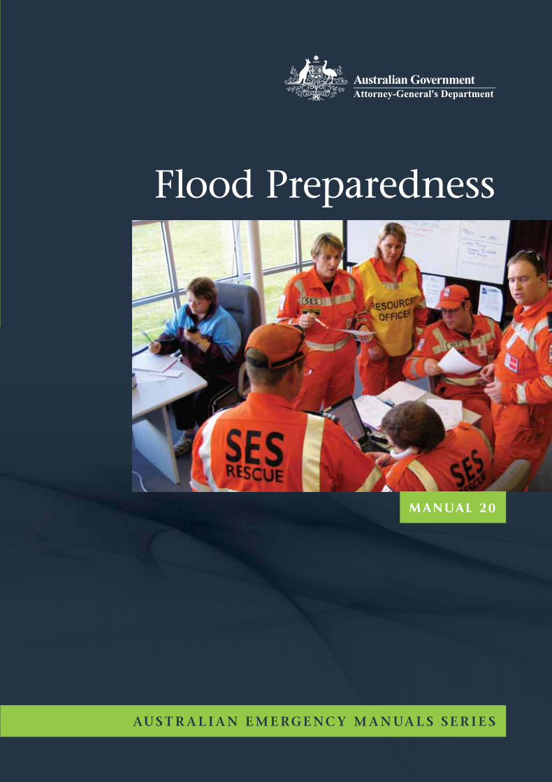
MANUAL 20 Flood Preparedness AUSTRALIAN EMERGENCY MANUALS SERIES
AU
ST
RA
LIA
N E
ME
RG
EN
CY
MA
NU
AL
S S
ER
IES
Floo
d P
repared
ness
MA
NU
AL
20
M A N UA L 2 0
Flood Preparedness
AUS T R A L I A N E M E RGENC Y M A N UA L S SER I E Sw w w.ema .gov. au
iM A N UA L 2 0 – F lo o d P r e p a r e d n e s s
Flood Preparedness
© Commonwealth of Australia 2009
First printed 1999
ISBN 978-1-921152-19-1
Basic editing and typesetting by Blue Square Design
Edited and published by Attorney-General’s Department
Printed in Australia by GEON Impact Printing, an ISO14001
and FSC accredited printer.
Cover image courtesy of Victoria State Emergency Service.

ii
AU S T R A L I A N E M E R GE N C Y M A N UA L S S E R I E S
CopyrightPermission to use the document and related graphics is granted provided that (1) the below copyright
notice appears in all copies and that both the copyright notice and this permission notice appear, and
(2) use of document and related graphics is for educational, informational and non-commercial or
personal use only.
In all cases the Commonwealth of Australia must be acknowledged as the source when reproducing or
quoting any part of this publication. Examples and quotations from other sources have been attributed
to the original publication whenever possible and are believed to fall within fair use provisions, but
these portions retain their copyright protection and must not be used without attribution.
Enquiries related to copyright should be addressed to:
Attorney-General’s Department
3 – 5 National Circuit
BARTON ACT 2600
Telephone +61 (0) 2 6141 6666
Any rights not expressly granted herein are reserved.
DisclaimerThis publication is presented by the Commonwealth Attorney-General’s Department for the purpose
of disseminating emergency management information free of charge.
The Commonwealth Attorney-General’s Department in consultation with emergency management
professionals and subject matter experts exercised care in the compilation and drafting of this
publication, however, the document and related graphics could include technical inaccuracies or
typographical errors and the information may not be appropriate to all situations.
In no event shall the Commonwealth of Australia (acting through the Attorney-General’s Department) be
liable for any damages whatsoever, whether in an action of contract, negligence or other tortious action,
arising out of or in connection with the use of or reliance on any of the information in this publication.
The Attorney-General’s Department periodically updates the information in this publication. Before
using this publication, please check to ensure that this edition is the most recent and updated version
of the publication.
Intellectual Property StatementIn contributing to the development of this manual, it is acknowledged that no ongoing rights to the
information are retained by individual contributors. The information contained within this manual is
not owned by individuals or State/Territory organisations but is held in trust by the Commonwealth
on behalf of the Australian community. The information contained within this manual is current as at
July 2009.
iiiM A N UA L 2 0 – F lo o d P r e p a r e d n e s s
Australian Emergency Manual SeriesThe first publication in the original Australian Emergency Manual (AEM) Series of mainly skills
reference manuals was produced in 1989. In August 1996, on advice from the National Emergency
Management Principles and Practice Advisory Group the AEM Series was expanded to include a more
comprehensive range of emergency management principles and practice reference publications.
The AEM Series has been developed to assist in the management and delivery of support services in a
disaster context. It comprises principles, strategies and actions compiled by practitioners with
management and service delivery experience in a range of disaster events.
The series has been developed by a national consultative committee representing a range of State and
Territory agencies involved in the delivery of support services and is sponsored by the Commonwealth
Attorney-General’s Department.
Details of the AEM Series are available on at www.ema.gov.au
Australian Emergency Manual Series structure and contentPrinciples and reference manuals
Manual 2 Australian Emergency Management Arrangements
Manual 3 Australian Emergency Management Glossary
Manual 4 Australian Emergency Management Terms Thesaurus
Manual 18 Community and Personal Support Services
Manual 29 Community Development in Recovery from Disaster
Manual 15 Community Emergency Planning
Manual 27 Disaster Loss Assessment Guidelines
Manual 9 Disaster Medicine
Manual 28 Economic and Financial Aspects of Disaster Recovery
Manual 8 Emergency Catering
Manual 1 Emergency Management Concepts and Principles
Manual 23 Emergency Management Planning for Floods Affected by Dams
Manual 5 Emergency Risk Management—Applications Guide
Manual 43 Emergency Planning
Manual 11 Evacuation Planning
Manual 20 Flood Preparedness
Manual 22 Flood Response
Manual 21 Flood Warning
Manual 25 Guidelines for Psychological Services: Emergency Managers Guide

iv
AU S T R A L I A N E M E R GE N C Y M A N UA L S S E R I E S
Manual 26 Guidelines for Psychological Services: Mental Health Practitioners Guide
Manual 44 Guidelines for Emergency Management in Culturally and Linguistically Diverse Communities
Manual 13 Health Aspects of Chemical, Biological and Radiological Hazards
Manual 6 Implementing Emergency Risk Management—A facilitators guide to working with
committees and communities
Manual 42 Managing Exercises
Manual 19 Managing the Floodplain
Manual 17 Multi-Agency Incident Management
Manual 31 Operations Centre Management
Manual 7 Planning Safer Communities—Land Use Planning for Natural Hazards
Manual 14 Post Disaster Survey and Assessment
Manual 10 Recovery
Manual 24 Reducing the Community Impact of Landslides
Manual 12 Safe and Healthy Mass Gatherings
Manual 41 Small Group Training Management
Manual 16 Urban Search and Rescue—Capability Guidelines for Structural Collapse
Skills for emergency services personnel manuals
Manual 38 Communications
Manual 39 Flood Rescue Boat Operation
Manual 37 Four Wheel Drive Vehicle Operation
Manual 35 General and Disaster Rescue
Manual 33 Land Search Operations (refer to website http://natsar.amsa.gov.au/Manuals/index.asp.)
Manual 32 Leadership
Manual 36 Map Reading and Navigation
Manual 34 Road Accident Rescue
Manual 30 Storm and Water Damage Operations
Manual 40 Vertical Rescue

vM A N UA L 2 0 – F lo o d P r e p a r e d n e s s
Contents
Chapter 1 the Need for Flood emergency planning 1In a Nutshell… 1
The Flood Problem in Australia 1
The ‘Manageability’ of Flooding 3
Setting the Scene 4
This Guide 5
Chapter 2 Understanding the risk 6In a Nutshell… 6
Introduction 6
Understanding the Flood Risk 6
Sources of Information 7
Information on Flooding and its Impacts 8
Understanding the Community 11
Identification of Elements at Risk 11
Vulnerability of People and Institutions 11
Identifying Vulnerabilities of Physical Structures 13
Assembling Information During Flood Time 14
Presenting the Information 15
Maps and Geographic Information Systems 15
Flood Intelligence Records 16
Chapter 3 Developing the plan 19In a Nutshell… 19
Introduction 19
Authority 20
Scope 20
The Risk 20
The Area 21
Integration 21
The Planning Process 21
Establishing a Project Plan 23
Establishing a Flood Emergency Planning Committee 23
Understanding the Risk 24
Developing Strategies and Arrangements 24
Documentation of the Plan 25
Endorsement of the Plan 25
Co
nt
en
ts

vi
AU S T R A L I A N E M E R GE N C Y M A N UA L S S E R I E S
Keeping Plans Alive 26
Review 26
Consultation and Communication 27
Structure and Content 27
Scenario-Based Planning 30
Matching Managers to Tasks 31
Supporting Information 31
Chapter 4 planning for Specific Functions 32In a Nutshell… 32
Introduction 32
Planning Considerations for Warning and the Provision of Advice 32
Prediction 33
Interpretation 33
Message Construction 33
Communication 34
Review 34
Planning Considerations for Evacuation 34
Decision 35
Warning 36
Withdrawal 36
Shelter 36
Return 37
Agencies and Organisations Potentially Involved 37
Time Considerations in Planning for Evacuation 37
Planning Considerations for Resupply 38
Planning Considerations for Property Protection 41
Barriers 41
Removal or Lifting of Contents 41
Key Considerations 41
Planning Considerations for Flood Rescue 42
Identification and Deployment of Rescue Resources 42
Activation of Rescue Resources 43
Rescue Execution 43
Shelter of Flood Victims 43
Return of Flood Victims 43
Chapter 5 planning for Special environments 44In a Nutshell… 44
Planning for Flash Flood Environments 44
Evacuation v Sheltering in Place 45
viiM A N UA L 2 0 – F lo o d P r e p a r e d n e s s
Co
nt
en
ts
Planning for Flood-Prone Communities with Levee Systems 45
Planning Considerations 46
Levee Heights 47
Freeboard and Levee Design 47
Planning For Areas Downstream of Dams 48
Understanding the Dam-Failure Risk 48
Planning Considerations 49
Other Dam-Related Flooding 50
Chapter 6 Using education to Increase Community resilience to Flooding 51In a Nutshell… 51
Introduction 52
Improving Community Flood Resilience through Education 52
Principles 52
Methods 54
Developing a Local Community Education Strategy 56
The Local Flood Education Strategy Committee 58
Using the Strategy 59
Potential Content Elements 59
Delivering Flood Education: Some Pointers 59
Private Flood Emergency Planning 63
Ongoing Educational Initiatives 64
Evaluation 65
Educating Decision Makers 65
Some Community Flood Education Initiatives in Australia 66
aNNex a Flood Intelligence Collection Sheet 68aNNex B a Sample Flood Intelligence record 69aNNex C a Checklist for Vetting for Quality 72aNNex D Floodplain Classifications 74acronyms and Glossary 75references 76

viii
AU S T R A L I A N E M E R GE N C Y M A N UA L S S E R I E S
ForeworD
Foreword
This Guide is the result of a review of the original Australian Emergency Manual Flood Preparedness
which was prepared in 1998-99 by a team of experienced flood planners from around Australia led by
Chas Keys, then of the New South Wales State Emergency Service. The review was conducted by
Andrew Gissing (Victoria State Emergency Service) and Chas Keys, with input from Allison Godber and
Nicola Moore (Emergency Management Queensland), Bob Stevenson (South Australia State Emergency
Service), Belinda Davies, David Webber, Catherine Moyle and Helen Halpin (New South Wales State
Emergency Service), Fiona Dunk, Myles O’Reilly and Justin Murray (Victoria State Emergency Service),
Mike Edwards (Victoria Department of Sustainability and Environment), Andrew Lea and Elke Browne
(Tasmania State Emergency Service), Miriam Middelmann (Geoscience Australia), Neil Dufty (Molino
Stewart) and Michael Cawood (Michael Cawood & Associates). All these people have considerable
experience and expertise in various facets of flood preparedness.
The Guide is one of a series of manuals on flood management whose review was instigated and
managed by the National Flood Risk Advisory Group, a sub-group of the Australian Emergency
Management Committee. The project was coordinated by Major General Hori Howard of the
Australian Council of State Emergency Services and made possible by the financial contributions of the
Commonwealth Attorney-General’s Department and the Australasian Fire and Emergency Service
Authorities Council.
The Guide is designed for use by all those who have roles to play in preparing communities for floods,
whether in lead or supporting agencies. These people will include emergency management
practitioners and members of agencies and organisations that will be involved in flood response
operations, including staff and volunteers in the State/Territory Emergency Service (S/TES)
organisations which in most jurisdictions in Australia have a lead role in the management of floods.
The document is intended to provide broad guidance on all the important aspects of flood
preparedness. It reflects considerable expertise developed over many years of flood planning and other
facets of flood preparedness in the Australian states and territories.
Like the other documents in the Australian Emergency Manual Series (Managing the Floodplain,
Flood Warning, Flood Response and Emergency Management Planning for Floods Affected by
Dams), the Guide focuses on defining ‘best practice’ as this is presently understood in Australia. It
does not seek to define or describe current practices, which may vary considerably between
jurisdictions. Users will find it valuable to refer to the companion documents and to other documents
in the Australian Emergency Manuals series.

ixM A N UA L 2 0 – F lo o d P r e p a r e d n e s s
Fo
re
wo
rd
Every attempt has been made to use neutral terminology. As a result the Guide does not use the
specific terminology (for example in relation to officers, programs and management structures) or refer
to the particular arrangements for flood management in the various states and territories.
Martin Studdert, AM
First Assistant Secretary
National Security Capability Development Division
Attorney-General’s Department

x
AU S T R A L I A N E M E R GE N C Y M A N UA L S S E R I E S
1M A N UA L 2 0 – F lo o d P r e p a r e d n e s s
Ch
ap
te
r 1
– t
he
ne
ed
Fo
r F
loo
d e
me
rg
en
Cy
Pl
an
nin
g
Chapter 1
the need for Flood emergency PlanningIn a Nutshell…Floodplains have been developed by rivers and accordingly will be inundated by floodwaters from
time to time. Flooding often has deleterious impacts on human activities and assets, but the
damage that floods cause can be reduced by careful planning and management of floodplain use.
The ‘manageability’ of flooding is enhanced by effective preparation for floods.
This preparation should be undertaken for all areas in which there is an interaction between
flooding and human activities. It should involve purposeful planning for floods and the engagement
and education of the members of flood-liable communities about flood risks and their management.
Flood emergency plans for particular areas should deal with the full range of types and severities of
flooding which could be experienced. This includes noting the potential impacts of climate change
and sea level rise.
It is necessary to determine in advance, as far as possible, what needs to be done when floods are
developing and occurring. Flood-liable communities should plan now so effective actions are taken
in the lead-up to, during and after the next flood.
Good flood emergency planning allows operations controllers to identify likely flood problems and
proactively manage them. Without good flood emergency plans, operations controllers may be
unable to identify flood problems clearly and they will be forced to react to problems as they develop
without an appreciation of the most effective means of their management.
Flood preparedness also involves the engagement of the members of flood-prone communities. This
engagement is necessary so that individuals understand the need to make their own preparations
for flooding and have the tools to do so.
The Flood Problem in AustraliaEvery year, despite the beneficial environmental impacts they create, floods impose substantial
economic, social and environmental costs on Australian communities through:
• directdamagetoresidential,commercial,educational,recreational,culturalandindustrial
buildings,
• damagetoinfrastructure,
• damagetostock,equipmentandfacilities(forexamplefarmanimals,machinery,commercial
stock and records and other contents of buildings),
2
AU S T R A L I A N E M E R GE N C Y M A N UA L S S E R I E S
Chapter 1
• indirectlossesduetodisruptionofeconomicactivity,bothinareaswhichareinundatedandin
areas which are isolated,
• stressandanxietyinthoseaffectedbyflooding,
• injuryanddeath,
• pollutedwatersupplies,and
• damagetowildlifehabitats.
In terms of economic costs to the community, flooding is Australia’s most damaging natural hazard.
Expressing in 2009 terms the costs estimated by the Bureau of Transport Economics (2001, p35) for
flooding in Australia between 1967 and 1999, floods cost approximately $420 million per annum on
average. Other sources put the average annual damage at rather higher levels when estimates are
expressed in current dollar terms (see, for example, Standing Committee on Agriculture and Resource
Management, 2000, p xi).
In most years, a small number of deaths occur as a consequence of flooding in Australia and there
have been many cases of multiple deaths in a single flood episode. Between 1788 and 1996 at least
2213 people were killed by floods in Australia. Particularly lethal floods occurred in Gundagai (New
South Wales) in 1852 (89 deaths), in the Claremont area in Queensland in 1916 (65 deaths) and in
Brisbane and Ipswich in 1893 (47 deaths), but several other locations or regions have recorded more
than 20 deaths in a single episode of flooding (Coates, 1996).
Large numbers of people in Australia live in flood-prone areas. Approximately 170,000 residential properties
are susceptible to flooding in the 100-year ARI (Average Recurrence Interval) flood (Leigh and Gissing,
2006). The number of commercial and industrial properties liable to flooding within the extent of the
100-year flood is not accurately known but would likely be measured in the tens of thousands, and the
value of the agricultural, industrial, commercial, residential and public assets that are at risk is very
large as is the cost of repairing or replacing infrastructure damaged or destroyed by flooding.
Of course, many more properties, sources of productive activity and critical items of infrastructure
would be affected in floods bigger than the 100-year flood. It is probable that the total value of the
assets at risk in Australia in Probable Maximum Flood (PMF) events – the biggest floods possible –
considerably exceeds $100 billion.
3M A N UA L 2 0 – F lo o d P r e p a r e d n e s s
Ch
ap
te
r 1
– t
he
ne
ed
Fo
r F
loo
d e
me
rg
en
Cy
Pl
an
nin
g
The ‘Manageability’ of FloodingFlooding is a highly manageable hazard where the flood risk can be defined and appropriate
emergency preparedness and mitigation strategies developed. Floods happen often in Australia and, in
some areas, according to a regular seasonal rhythm. Their location is predictable and there is usually
some warning of their occurrence. Often it is possible to determine who will be affected and what
problems will be encountered as far as warning, evacuation, property protection, rescue, resupply and
other functions are concerned. Much can therefore be known about a flood and its likely consequences
before it occurs. Because of this, the opportunity exists to work out in advance (ie to plan) how a flood
can be best managed in the interests of maximising public safety and minimising property and other
damage. This allows for the investment of money and effort in the management of flooding.
To reduce the negative impacts of flooding, many measures have been devised to help communities
adjust to and live with the flood hazard. These measures have included:
• constructinglevees,floodbypasses,channelimprovements,detentionbasinsandflood
mitigation dams,
• institutinglandusecontrols(suchaszoningandtheremovalofexistingbuildings)andbuilding
restrictions (such as establishing minimum floor levels and raising buildings) in relation to
development on flood-prone land,
• developingwarningsystems,
• developingresponseandrecoverycapabilities,and
• encouragingcommunityunderstandingofboththefloodthreatandthemeansbywhichpeople
can manage it.
While these measures rarely remove the flood risk entirely, they can modify the characteristics of
flooding, alter communities in ways that reduce the impact of floodwaters and provide mechanisms
that enable communities to cope better with flooding. For more detail on these measures, see Annex B
of the Australian Emergency Manual Managing the Floodplain.
Preparing for floods through flood emergency planning, exercising and community engagement
enables a proactive response to flooding to be developed. Without preparation, flood response would
become primarily reactive, reducing the opportunities to respond in the optimal time frames and with
maximum efficiency through warning, evacuation, rescue, property protection and other activities.
The most effective flood responses are likely to be those which have been thought about and planned
for in advance. Preparing properly for floods, therefore, is likely to result in increased public safety,
reduced property damage and faster community recovery.

4
AU S T R A L I A N E M E R GE N C Y M A N UA L S S E R I E S
Chapter 1
Setting the SceneThe central purpose of flood preparedness is the building of community resilience against the flood
risk. This involves the agencies and organisations charged with the management of flooding, but also
the people who live, work or have other interests in flood-prone areas. For flood preparatory initiatives
to be effective, agencies, organisations and people must be engaged. Procedures must be developed to
address the actions which will be carried out by specified agencies and organisations, but they should
also deal with building the readiness and ability of people in flood-prone communities to manage
their own interests when flooding occurs.
Much of the work of flood preparedness involves the development of flood emergency plans, often at
different jurisdictional levels (eg local, regional and state). A flood emergency plan is often defined as a
statement of intent containing an agreed set of arrangements which define the framework for the
control and coordination of a flood emergency. In essence a flood emergency plan is a script detailing
the progression of emergency management functions and identifying the parts each actor must play.
In short, it is a ‘record of intended proceedings’.
But flood emergency planning should go beyond the development of arrangements for dealing with
actual episodes of flooding. It should also incorporate the activities which will be need to be developed
to raise the consciousness of members of the community as far as the flood risk is concerned and to
build people’s ability to respond effectively in their own interests to floods.
Flood emergency planning seeks to define the roles and responsibilities of the agencies that are
involved in flood management. It also outlines appropriate strategies for the carrying out of key flood
management functions. Flood emergency plans consolidate working partnerships between key
management agencies by ensuring that each agency listed within a plan understands and agrees to its
responsibilities. Flood emergency plans should also consolidate partnerships between agencies and the
members of flood-prone communities.
The scope of flood emergency plans must be holistic, by ensuring arrangements exist for coordination
across the management elements of prevention, preparedness, response and recovery. Considering all
these elements ensures the minimisation of the effects of flooding on the community and enhances
the ability of the community to recovery from floods. Plans should also address the full range of
possible flood types and the full range of possible severities, from minor or nuisance floods to events
of PMF proportions where these have been established.
The interaction between a flood emergency plan and any floodplain risk management plan for an area
is important and it is vital that the two documents are consistent in content. This will help ensure
management of the flood risk is carried out in a holistic fashion and without confusion.
5M A N UA L 2 0 – F lo o d P r e p a r e d n e s s
Ch
ap
te
r 1
– t
he
ne
ed
Fo
r F
loo
d e
me
rg
en
Cy
Pl
an
nin
g
Assessments about the level and focus of the planning should be made using an emergency risk
management approach incorporating formal hazard and community analyses to establish elements at
risk and their associated vulnerability. These analyses will need to consider the physical characteristics
of flooding in the area and the nature of the community and its assets. By adopting an emergency risk
management approach, strategies can be determined as to how flood-affected communities can
identify, analyse and treat their flood problems to provide solutions.
Flood emergency planning in Australia needs to note the likelihood that climate change will alter the
nature of flood risk. It is becoming accepted that rises in sea level, which have already occurred and
which are ongoing, will alter the flood regime in coastal and estuarine areas, making flooding both
more frequent there and more severe in its impacts. Changes in rainfall intensity over much of
Australia may also have the effect of making severe flooding a more frequent occurrence
(Intergovernmental Panel on Climate Change, 2007).
This GuideThis Guide is not intended to be totally prescriptive and all parts of it will not be appropriate to every
situation. However, it does outline a range of procedures from which individuals or organisations
charged with developing flood emergency plans can select. The application of the Guide will ensure
the best available management techniques have been considered in developing a flood emergency plan
that will help those responsible for the operational management of floods.
The Guide sets out the means by which flood emergency planning should proceed and is thus
intended to facilitate the development of such plans. The planning itself will help the community
come to grips with the problems floods will create before they are actually encountered. It will do this
by ensuring that management arrangements and solutions can be devised methodically and with
appropriate consultation in an atmosphere free of the stresses which actual events create. The planning
will also help, along with programs to educate people about their flood risk, to build the commitment
of the members of flood-prone communities to managing ’their’ floods when they occur. Flood
preparedness includes providing people with the tools they need to stay safe and protect their interests.
Planning to handle threats is part of making sure community preparedness for those threats is
developed and maintained so that community resilience is augmented. It is a fundamental principle of
emergency management that communities which have thought about a problem and planned for it
beforehand will be able to cope better than those which have ignored it and hoped it will never occur.
6
AU S T R A L I A N E M E R GE N C Y M A N UA L S S E R I E S
Chapter 2
Chapter 2
Understanding the risk
In a Nutshell…To plan for floods in an area requires a comprehensive understanding of the flood threat, the
community and the nature of the interaction between them. Understanding the risk involves
developing a knowledge of the flood hazard and its impacts.
There is a wide range of sources and types of information which should be examined. Flood
intelligence, which summarises the impacts of flooding of different severities, is a critical input to
the planning process.
Flood intelligence should be continually reassessed and kept up to date. This includes collecting
intelligence during actual floods and recognising that the characteristics of floodplains and
communities are subject to change, affecting the impacts of flooding and the nature of the required
emergency responses.
IntroductionTo plan for and respond to floods in an area requires a thorough understanding of the flood risk, the
community and the nature of the interaction between them. Information about flood behaviour and
its effects on a community is critical to effective flood management because it provides a basis for
determining how response operations should be conducted.
This chapter focuses on how an appreciation of the flood risk can be achieved, using flood intelligence
(sometimes referred to as flood information) about that risk.
Flood intelligence is the product of a process of gathering and assessing information to assist in the
determination of the likely effects of a flood upon a community. These effects vary with the scale of
flooding, and flood intelligence is typically presented in terms of the relationship between flood
severity and flood consequences.
Understanding the Flood RiskThe process of flood emergency plan preparation begins with an analysis of the area’s flood risk. This
appraisal must extend to full consideration of the:
• sourcesoffloodrisk,
• potentialelementsatriskofflooding,and
• thevulnerabilityofthethreatenedcommunitytoflooding.

7M A N UA L 2 0 – F lo o d P r e p a r e d n e s s
Ch
ap
te
r 2
– U
nd
er
st
an
din
g t
he
ris
k
Typically the appraisal will involve identifying the sources of risk, their likelihood and the evaluation
of potential consequences in terms of impacts on the community.
The first step in defining the flood threat to a community is to establish, from a range of sources, the
nature and extent of flooding in the area. The collection, assessment and collation of material
associated with past and potential future floods is essential to the development of an effective flood
emergency plan. Information about flood behaviour and the consequences of flooding must be built
into the planning process if operational decisions are to be soundly based and warnings targeted
effectively.
Some agency must take responsibility for the development of flood intelligence.
Sources of InformationThe development of a flood emergency plan should be based on information from a wide range of
sources that can provide material on the temporal and spatial development of floods and their
consequences. Both quantitative and qualitative information should be sought although it is desirable
that plans be based on as much ‘hard’ data as possible. This is especially so for areas with a high
incidence of flooding or an unusually severe flood problem, and for rare, large events.
Food-liable communities are repositories of information about floods and their impacts, and an effort
should be made to tap into their experience and knowledge of the flood hazard. A record of
community experience will improve the documentation of flood history in the area and can be used
to make the prospect of flooding more ‘real’ to people. By itself, however, community knowledge will
not be sufficient even if it has been built up over a long period. This is partly because people who have
lived with and responded to floods over many years are likely to be constrained by their own
experiences and may be unable to contend effectively with floods which differ from or are more severe
than those they have witnessed. Larger floods than these people have witnessed will inevitably occur
from time to time.
Other perspectives must be included. Engineers and hydrologists will be able to bring a scientific
appreciation to the definition of the hazard and to the estimation of the potential consequences of flooding
of different magnitudes. If the potential flood threat includes spills or releases from dams, or the
failure of dams, the expertise of dam owners and/or dam safety regulatory authorities should be sought.
Specific sources of information on flood problems could include those listed in Table 1.

8
AU S T R A L I A N E M E R GE N C Y M A N UA L S S E R I E S
Chapter 2
table 1: Information Sources and availability
Information Source available From
Flood studiesCouncils, catchment management authorities, state emergency service, state/territory governments, libraries
Floodplain management studiesCouncils, catchment management authorities, state emergency service, state/territory governments, libraries
Coastal zone management studiesCouncils, state emergency service, state/territory governments, libraries
dam-break studies dam owners
levee studiesCouncils, state water and floodplain management agencies, state emergency service, libraries
historical recordsCouncils, catchment management authorities, state emergency service, media, historical societies, museums, community members
Flood mitigation design studies Councils, operators of flood mitigation schemes
road and infrastructure design studies road owners
Buildings, infrastructure and people, including census information
Councils, catchment management authorities, australian government
Community experiences Personal histories, newspaper archives
The online Australian Flood Studies Database (www.ga.gov.au), instigated and managed by the
Australian Government, provides information on flood studies undertaken nationally.
Emergency planners should be consulted when flood risk and floodplain management studies are
prepared to ensure that their information requirements are met.
Information on Flooding and its ImpactsMuch of the information which can be tapped will relate to past flood events, but some sources will
provide estimates for floods of severities not experienced in the usually relatively short period since
record-taking began. The information sought should include:
• thetypes of flooding which could occur (eg riverine, dam failure, coastal storm surge, flash
flooding and, if not defined as a separate hazard, tsunami),
• physical and geographical characteristics of the area, including:
9M A N UA L 2 0 – F lo o d P r e p a r e d n e s s
Ch
ap
te
r 2
– U
nd
er
st
an
din
g t
he
ris
k
• theshapeandextentofthefloodplain(iewhetheritiswide,narrow,steep,flat,welldefined
with identifiable benches and escarpments, etc),
• streamcharacteristics(whetherthewatercoursesaresingle-channelled,braided,
convergent or divergent, with steep or mild bed-slopes and escarpments, etc),
• distancefrom,andrelativeelevationof,townsorothersettledareaswithrespecttothe
river, creek, lake or sea,
• anybridges, embankments or other flow-restricting structures,
• thelocationandnatureofanyflood mitigation or control works, and
• thelocationofanydams, their size, details of control structures and operating rules for
releases, and any known physical or structural deficiencies or potential for failure under
severe flood conditions,
• land use, ie whether the flood-liable areas are under rural, urban, industrial, commercial, service
or infrastructure uses, and the changes that are occurring with time,
• typicalpre-flood conditions, ie weather or synoptic conditions that usually precede or lead to a
flood; and times (in terms of season or month) of greatest vulnerability to or likelihood of flooding,
• impact and severity of flooding as indicated by areal extent at particular heights at key or
referable locations and in terms of velocity of flow,
• impacts on the community, including the extent of community disruption as defined by:
• numberandlocationofpropertiesactuallyfloodedinhistoricevents(andtowhatdepths),
and whether the residents were surrounded by water or experienced access difficulties at
various gauge heights,
• numberofcasualtiesordeathsrecordedinpastevents,
• extenttowhichindividualsand/orcommunitiesseethemselvesasvulnerabletoflooding,
• accessdifficultiesand/orisolationincludingroad,railandairportclosuresandthelength
of time these extend, together with estimates of likely needs for resupply,
• durationoffloodinginparticularareas,includingtheincidenceofstormwaterback-up
and/or entrapment and drain blockages,
• extentofpreparation(orlackthereof)inpastevents,
• warning(orlackthereof)inthepast,
10
AU S T R A L I A N E M E R GE N C Y M A N UA L S S E R I E S
Chapter 2
• numberandlocationofpotentialevacueesinfloodsofdifferentmagnitudes,and
• theextenttowhichlifelines(egservicedeliveryandinfrastructuresupport)arevulnerable
to flooding,
• thefrequency of flooding of different severities, including how often rivers or creeks breaks
their banks, cause roads/bridges to be closed, flood houses and necessitate evacuations,
• output from specialist hydraulic/hydrologic analyses of available data to define hydrologic
characteristics such as:
• therateofriseoffloods(egrapidriseoftheorderofxmetresperhourinitially,thenslow
rise to peak) and their progress (eg areas first affected, incidence and location of ‘shrinking
islands’, identification of low points on escape routes, etc),
• theinfluence(andcontribution)ofstormwateronthespeedofriseandprogressoffloods,
• thesignificance(ifany)ofbackwatereffects,
• watervelocitiesanddepths(includingidentificationofareaswherevelocitiesand/or
depths are likely to be high) and their impacts,
• timingcharacteristicssuchasthetimebetweenrainstarting/stoppingandtheriverrising
for the first areas being flooded, and the time taken for floods to travel between significant
and easily-referable locations,
• thedurationoffloods(egthelengthoftimetheriverstayedatitspeakand/orabove
critical levels and the time it took to drain away),
• sourcesoffloodwaters(sub-catchmentcontributions),andwhererelevant,
• tidalconditionsatthetimeoftheonsetandpeakofthefloodandtheimpactoftidal
fluctuations on river flood conditions,
• analysisofavailabledatatoidentifycauses of floods, in terms of:
• rainfallcharacteristics(egdepth,intensity,incidenceofthunderstorms),
• seasonalcharacteristics(egunusuallywet/dry,winter/spring),and
• antecedentconditions(egfloodoneweekearlier,rainforprecedingweek).
• the thought processes which people go through and the tasks community members will
need to perform when floods are approaching and occurring, together with estimates of the
time needed to carry the tasks out. Such tasks may include:

11M A N UA L 2 0 – F lo o d P r e p a r e d n e s s
Ch
ap
te
r 2
– U
nd
er
st
an
din
g t
he
ris
k
• relocatinglivestock,equipmentandrecords,
• raisingorrelocatingfurniture,memorabilia,documentsandotherbelongings,
• stockinguponessentialsbeforenormalaccesstolocationsofsupplyislost;and/or
• evacuatingtosafety.
This information on the nature of flooding in an area provides the basis for developing flood
intelligence records and an increased understanding of the nature and effects of flooding.
Understanding the CommunityThe second step in defining the flood threat is to undertake an analysis of the threatened community.
This involves establishing a community profile, identifying the elements at risk and their vulnerability.
The profile should be regularly reviewed to capture demographic and other community changes.
Identification of Elements at RiskAfter identifying the likely extent of flooding, it will be possible to identify the elements potentially
exposed and any interdependencies between elements. During this process it is important to identify
any flood-prone infrastructure and to analyse any indirect consequences upon the community and
other infrastructure assets as a consequence of interruption to identified elements. Each element will
have an associated vulnerability which will need to be identified.
Vulnerability of People and InstitutionsSome members of the community are especially susceptible to flooding because of:
• where they live (eg on a floodplain close to a river, creek, lake or the sea; in low-lying areas that
are easily inundated; or in floodways and flow paths where water velocities may be high), and/or
• in-built personal characteristics which affect their ability to protect themselves appropriately
from or respond to flood situations (eg age, disability, or personal beliefs about flooding).
Because of such characteristics, some people require special consideration in the planning
process and special assistance when a flood threatens. Others are likely to be more resilient and
able to cope with less external assistance.
Some communities, or parts of them, develop effective strategies to cope with flooding because of periodic
or regular exposure to it. For example, many farmers are used to and adept at handling floods because of
the problems which result from occupying highly flood-prone land. The frequency of inundation of rural
land alongside rivers, combined with the losses which result if stock and equipment are not moved before
floodwaters arrive, give farmers an expertise generated by learning from exposure to the hazard.

12
AU S T R A L I A N E M E R GE N C Y M A N UA L S S E R I E S
Chapter 2
Not all people who live in flood-liable locations, however, are able to develop experientially-based
strategies to ensure costs are minimised. Some are only occasionally threatened by flooding and, in a
highly mobile society such as Australia, many people have been in their present locations for only
short periods of time. As a result they are unlikely to have experienced flooding in their current
environment and may be unaware of the potential for flood events. Equally, extended periods of time
between floods can lessen the risks perceived by long-term residents, particularly when urbanisation
obscures the appearance of floodplains.
It is possible, using population census data and other information held by councils and state agencies,
to identify the potential number and location of people in an area (or the proportion of the
community’s population) with special needs or requiring additional support during floods.
In general, people who belong to the following groups may be considered especially susceptible to the
hazards floods pose:
• Theelderly, especially those living alone and/or frail, who are often unable to respond quickly
or without assistance,
• Thepoor (ie those with low incomes, including the unemployed and others on pensions), who
tend to lack resources which would give them independence of decision making and action,
• Single-parentfamilies, large families or families with very young children: these may be
characterised by unfavourable adult:child ratios making evacuation difficult,
• Thoselackingaccesstoamotorvehicle frequently need special transport provision to facilitate
escape from threatening floodwaters,
• Newcomers (ie those resident in their communities for only short periods), who are unlikely to
appreciate the flood threat and may have difficulty understanding advice about flooding. They
may need special attention in terms of threat education and communication of warnings and
other information,
• MembersofCulturallyandLinguisticallyDiverse(CALD)communities, who need special
consideration with respect to the development of preparedness strategies as well as warnings and
communications during flood events. Special attention may also be needed if actions which
become necessary during floods offend cultural sensitivities,
• Theill or infirm who need special consideration with respect to mobility, special needs, medications,
support and ‘management’ to ensure they continue to receive appropriate care and information, and
• Thosewhosehomesareisolatedbyfloods, creating a potential need for medical evacuation or
resupply of essential items.
13M A N UA L 2 0 – F lo o d P r e p a r e d n e s s
Ch
ap
te
r 2
– U
nd
er
st
an
din
g t
he
ris
k
Knowing where the most vulnerable people are is important when allocating appropriate resources
before, during and after flood events. It will make it easier to plan effectively for floods, particularly in
the contexts of hazard education, the delivery of warnings and the management of evacuation.
Vulnerability also has a psychological dimension. Some people are prone to deny the flood risk or to
be complacent about it, some are more likely to act purposefully when floods approach than are
others, and some may react irrationally during floods. Aspects of this dimension can be identified in
the process of gathering flood information from the community, and it can be explored in the process
of educating community members about flooding and their management of it.
This could include information on:
• the level of apathy or complacency about flooding,
• the degree of uptake of advice on property-damage mitigation and evacuation,
• the reliance on local knowledge, and
• the level of participation in flood emergency planning activities (including community
education initiatives).
While an understanding of the needs of individuals and households can be sought via demographic
analyses, it is also necessary to take note of the needs of critical facilities and institutions. Schools,
nursing homes, senior citizens’ centres, hospitals, child care centres, caravan parks, hostels, libraries,
art galleries, museums, gaols, sporting facilities, business districts and industrial areas located in
flood-liable areas may require attention with regard to education about the flood threat and the
provision of flood warnings. They may also need help with evacuation during floods. In all cases the
potential impact of flooding should be made known to the relevant managers.
Identifying Vulnerabilities of Physical StructuresThe vulnerability of physical structures potentially exposed to flooding must also be assessed. The
following characteristics of structures can contribute to their vulnerability:
• Constructiontype: some building materials are more susceptible to flood damage than others.
Some structures on floodplains may also be raised, reducing their susceptibility to direct flood
damage. Raised buildings may, however, encourage occupants to shelter within them during
floods, creating a risk that they may become trapped and require resupply or rescue,
• Age: older structures if not well maintained may be more susceptible to direct flood damage.
There may also be heritage considerations with these structures and a need to identify them as
requiring property protection measures,

14
AU S T R A L I A N E M E R GE N C Y M A N UA L S S E R I E S
Chapter 2
• Maintenance: poorly maintained structures are more susceptible to direct flood damage,
including structural failures, and
• Degreeofflood-proofingofstructures: some structures have specific flood-proofing measures
(eg flood barriers) available to them. These may help to reduce direct flood damage to the
structure and its contents.
Assembling Information During Flood TimeWhile most of the information and data referred to above comes from studies and reports and is
extracted outside flood time, it is also necessary to collect information while floods are actually
occurring. For example, information on the impacts of flooding at different gauge heights must be
collected as a flood rises; if it is not, post-flood appraisals will have to rely on potentially inconsistent
and inaccurate reports to build the store of data for use during later events.
It is also useful to record how people acted during a flood, for example in reacting to flood warnings,
in property damage mitigation activity and in evacuation behaviour. Doorknockers providing
warnings in the field will often be able to provide insights on these issues.
Flood consequence information can be gathered by recording observed impacts at particular locations
at specified times. A hydrograph for the appropriate flood warning gauge will then allow the matching
of consequences to flood heights. A flood intelligence collection sheet can be used to assist with this
process: see Annex A for an example.
When collecting flood observations, it is useful to consider:
• video footage, photographs and remote sensing as useful ways of recording observations. Note
that the time and location of the imagery must be recorded,
• the recording of effects that are not occurring (for example, low points on roads which are not
yet covered with water) as well as effects that are occurring,
• means of ensuring that all operational information is captured. Often valuable information is
collected on whiteboards, but is lost when boards are cleaned. Photographs should be taken of
the relevant boards or the relevant information scribed,
• having observers look, after floods, for debris marks which will provide an indication of flood
depths and extent. Surveys of depth marks and flood extents can assist in the future calibration
of flood models.
15M A N UA L 2 0 – F lo o d P r e p a r e d n e s s
Ch
ap
te
r 2
– U
nd
er
st
an
din
g t
he
ris
k
Flood intelligence collection during and after floods needs to be carefully planned before flooding
occurs so that the observers can be trained and necessary equipment and resources assigned. If this is
not done, it is likely that the information required will not be obtained, or unusable information will
be collected.
Key equipment that observers require may include vehicles, personal protective equipment for flood
conditions, flood intelligence collection sheets, pens, notebooks, cameras, watches, measuring tapes,
maps, charts and Global Positioning Systems (GPSs).
For flood intelligence to be generated effectively, the collection of data to establish height/consequence
relationships must be given a high priority. Appropriate resources must be allocated to the task and
capabilities developed. Requirements will include the following:
• field personnel specifically allocated to data gathering,
• operations centre staff to record such data, and
• a capacity to debrief data collectors and operations staff (including doorknockers where
applicable) immediately after a flood.
Presenting the InformationHaving gathered information about the flood hazard and the community at risk, there are several ways
to overlay it in order to maximise its value to planners. Potential vehicles of presentation include maps,
flood intelligence records and Geographic Information Systems (GIS).
Maps and Geographic Information SystemsMost flood and floodplain risk management studies already include maps showing the extent of one or
more historical events along with a range of design floods. As a first step the design flood contours
could be equivalenced to levels at the reference gauge. This information is generally included in flood
study reports. It is relatively straightforward to digitise flood extent information and overlay it with
appropriate census and other community data, on topographic or cadastral maps.
Using GIS, the characteristics of flooding (in terms of such things as spatial extent and depth) can be
depicted for specified design floods or to record historic events. An especially valuable application
involves the creation of dynamic simulations of developing floods, illustrating the sequence by which
areas are inundated (see Crowe et al, 2003) and allowing manipulations of time frames to illustrate the
varying conditions under which decisions might have to be made during different flood scenarios.
16
AU S T R A L I A N E M E R GE N C Y M A N UA L S S E R I E S
Chapter 2
Community information (eg the locations of vulnerable groups or individuals, evacuation routes etc)
can then be added to maps as overlays. Coupled with a reasonable flood height prediction and other
flood intelligence, such maps can greatly assist planning and response activities through identifying
areas and community groups likely to be affected in various ways and to particular extents by floods of
differing magnitudes. The information can be used to develop warning systems and procedures and to
generate decisions relating to evacuation, resupply and other response tasks.
Further information on the use of GIS in flood management can be found in Chapter 4 of the
Australian Emergency Manual Flood Warning and Chapter 3 of the Australian Emergency Manual
Flood Response.
Because electronically-stored data is vulnerable to loss of power supply during emergencies, hard copies
(ie paper maps) should also be kept.
Flood Intelligence RecordsFlood intelligence records can be developed for the reference area around a stream gauge, both
upstream and downstream. This is the area for which heights at the gauge have meaning in terms of
riverine flooding, independent of local flooding or flooding from tributary creeks (for further detail,
see Chapter 4 of the Australian Emergency Manual Flood Warning). The entries themselves should
consist of the known or estimated heights at which phenomena such as the following occur:
• floodwatersencroachonspecifiedfarmlands,caravanparks,residentialandbusinessproperties,
community facilities, institutions (eg nursing homes and schools) and utilities (eg sewerage and
water supply systems) Impacts at different locations can be indicated by map grid references,
• buildingsarefloodedovertheirfloorboards,
• roadsarecut,causingindividualhousesorcommunitiestobecomeisolatedandtraffic
movements to be disrupted,
• railwaylinesarecut,
• airfieldsareinundated,
• othersignificanteffects(includingtheovertoppingoflevees)occurorcanbeexpected,and
• significanthistoricfloodspeaked,orparticulardesignfloodssuchasthe1%AnnualExceedence
Probability (AEP) event or PMF would peak.

17M A N UA L 2 0 – F lo o d P r e p a r e d n e s s
Ch
ap
te
r 2
– U
nd
er
st
an
din
g t
he
ris
k
In compiling these records, care should be taken to:
• ensurethateffectsarecorrectlyascertainedinacausativesenserelativetogaugeheights(ie
things which happened, but which did not relate directly to specified heights being reached
during a particular event, must not be recorded against those heights),
• notewhereanimpactataparticularheightatagaugewilloccuronlyifsomeothereffect,
unrelated to that gauge, also occurs (eg a road being cut at a certain height, necessitating a longer
journey on an alternative route between two places but with the possibility of all access being
lost when this route closes as a consequence of flooding on another stream),
• ensurethateffectsareexplicitlynotedintermsoflocationsofimpacts,roadsclosedtodifferent
classes of vehicles and properties affected in different ways (eg by inconvenience, if additional
distance is added to journeys, or by complete isolation which may necessitate resupply, or by
inundation), and
• keepdetailedlistsofaffectedproperties,bytype(residential,farm,retail,industrial,caravan
park, etc).
It should be noted that virtually all flood intelligence records are approximations. This is because no
two flood events at a location, even if they peak at the same height, will have identical impacts. The
gradients of the floods may differ, the floods may be near their peaks for different durations, and the
channel and floodplain environments in which they occur are unlikely to remain static.
The fact that height/consequence links are approximations (and in some cases may be estimates of
likely occurrences) should not be of concern, however. Absolute precision in these matters is not
necessary for effective planning to be undertaken. The alternative to imperfect information would be
to have no recorded information at all on which to base operational decisions and construct warning
messages. Where substantial known variability exists in the heights at which particular effects can
occur, this can be noted by listing a range of heights.
Apart from recording height/effect relationships, the records may indicate specific actions which may
need to be:
• undertaken before specific heights are reached (eg barricading a road which will be dangerous
to travel on or closing drainage valves to prevent backwater flooding), or
• completed in advance of floodwaters reaching particular levels (eg moving farm animals
before paddocks are inundated, evacuating people to safety before escape routes are cut, or
removing electric motors from sewerage pumping stations to prevent submergence).

18
AU S T R A L I A N E M E R GE N C Y M A N UA L S S E R I E S
Chapter 2
In such circumstances, indications of the amount of time required to carry out the required actions
are particularly useful.
Recording heights against consequences and actions helps develop a forward planning tool for flood
managers which allows them to look ahead to ensure responses occur at appropriate times. In turn,
this will mean that actions which need to be undertaken are carried out when they can be done rather
than when they are most needed to be done – which is often later than is preferable. Estimating the
amounts of time needed to carry out these tasks will facilitate their successful completion.
An example of a flood intelligence card is shown in Annex B.
19M A N UA L 2 0 – F lo o d P r e p a r e d n e s s
Ch
ap
te
r 3
– d
ev
elo
Pin
g t
he
Pl
an
Chapter 3
developing the Plan
In a Nutshell…The authority to plan, the scope of a plan and the integration of the plan with other documentation
must all be defined and a clear planning process established.
Planning must be inclusive of the full range of agencies and organisations with flood management
roles to play and of the community at risk. Broadly-based participation is essential.
Planning should cover the tasks expected to be carried out and should identify the agencies which
will manage them.
Planning should identify solutions to the problems which will be experienced in carrying out
warning, evacuation, resupply, property protection, rescue and other tasks. These solutions should
be developed in relation to the full range of possible flood types and severities in the area and in
relation to any special environments (eg flash flood environments, communities with levees and
communities downstream of dams with identified deficiencies.)
The process of developing a flood emergency plan consists of the following phases: establishment of a
project plan, establishment of a flood emergency planning committee, understanding the risk,
developing strategies and arrangements, documenting the plan, implementing the plan and
reviewing the plan. In most cases, Standing Operational Procedures (SOPs) will also be required to
guide intended actions.
The planning process must go beyond developing actual planning documents. It must include
agencies and the community accepting and endorsing the plans.
IntroductionThe goal of flood emergency preparation is to lead, guide and build the community’s response to
flooding so as to maximise the safety of individuals, minimise property and infrastructural damage
and ensure the community’s effective functioning is maintained as far as possible and, where
impaired, is restored speedily. To achieve this goal an ordered planning process must be followed.
Planning must incorporate input from a wide range of interests drawn from the agencies which have
roles to play before, during and after floods and from the flood-liable community itself. The most
effective flood planning is shared with and engages the members of flood-liable communities.
The authority for the development of a formal flood emergency plan should be established and the document
itself properly integrated with the emergency management arrangements which apply in the area for which
it is written. A clear content and structure are required, together with a set of actions and procedures to
ensure the document is kept alive, relevant to its task and accessible to and understood in the community.
20
AU S T R A L I A N E M E R GE N C Y M A N UA L S S E R I E S
Chapter 3
As for any plan, there should be a vetting process whereby quality assurance can be achieved. Annex C
incorporates a checklist to guide this process in relation to flood emergency planning.
AuthorityFor a flood emergency plan to be developed, some agency must have the authority or responsibility to
undertake the process which will produce it. Authority will usually be established in legislation, where
a ‘lead’, ‘combat’ or ‘control’ agency for the management of flooding may be identified, or in local
emergency management arrangements which may allocate the planning task to a particular agency.
Authority is best vested in a single agency with access to expert advice, other stakeholders being
required to assist. Ideally, the agency with the authority to plan should also be the agency with control
responsibility when flooding actually occurs, and the agency charged with developing and
maintaining flood intelligence. Such a clustering of responsibilities under a single key agency
encourages the development of flood management expertise within that agency and maximises its
ability to exercise leadership in flood management.
The agency identified has responsibility for leading and driving the process. This responsibility
includes the requirement to develop an appropriate level of expertise in flood management itself and
in planning to facilitate effective management.
ScopeNo flood emergency plan can be effective without clear identification of its scope. This is best defined
in terms of threat and reference area.
The scope of flood emergency planning will vary from area to area depending on the severity and
complexity of the threat. Where the problem is serious and multi-faceted, the plan will need to address
a wide range of preparedness, response and recovery issues and may need to include a long list of
agencies with tasks to fulfil. The result, in such a case, may be a lengthy document.
Other areas, less severely affected, may require less detail in their flood emergency plans. In some areas
where the flood problem is minor a free-standing flood emergency plan may not be necessary. In such
cases flood management responsibilities could be discharged by recording general flood management
arrangements in an annex of the relevant local emergency or disaster plan.
The RiskThe plan must make clear the types and severities of flood hazards addressed. Potentially, flooding
may occur from:

21M A N UA L 2 0 – F lo o d P r e p a r e d n e s s
Ch
ap
te
r 3
– d
ev
elo
Pin
g t
he
Pl
an
• rainfalloverwhelmingthecapacityofnaturalandartificialdrainagechannels(riverineandflash
flooding),
• coastalstormsurge,
• damfailure,and(ifdefinedasfloodingratherthanasaseparatehazard)
• tsunami.
This means the nature of the problem of flooding must be established along with the magnitudes of
flooding which are to be addressed. Ideally the plan should deal with all types of flooding which could
occur in the area and with magnitudes ranging from small to extreme events.
The AreaFlood emergency plans should be written for defined communities (for example local government
areas, or combinations or parts of them). It may be desirable to divide the area to which the plan refers
into sectors: this may be appropriate in situations where different parts of a community become cut off
from each other when flooding occurs or to facilitate operational management in floods which have
impacts over large areas or on large numbers of people.
IntegrationFlood emergency plans should not exist as isolated documents. There may be flood emergency plans
written for local areas, regions and states, and all flood emergency plans of whatever level or type need
to be integrated within the appropriate emergency management structure for their individual areas of
reference.
Some flood emergency plans will also need to be cross-referenced to other planning documents.
Examples might be dam safety emergency plans or levee operation plans.
The Planning ProcessThe process of developing a flood emergency plan aims to produce a shared understanding of agreed
arrangements between agencies. It is essential that all key agencies, local government and the
community are involved in the planning process.
The process does not just produce a flood emergency plan. It forms an important learning exercise
where participants become familiar with:
• thenatureofthefloodhazard(s)inthearea,
• thenatureofthecommunityinrelationtofloodawareness,knowledgeandexpectedfloodresponses,

22
AU S T R A L I A N E M E R GE N C Y M A N UA L S S E R I E S
Chapter 3
• therolesandresponsibilitiesofagenciesandorganisationswithintheareacoveredbytheplan,
and
• keystrategiesforprevention,preparation,responseandrecovery.
The planning process is continuous. The key steps in the planning process are shown below, with each
step explained in the following paragraphs.
Con
sulta
tion
and
Com
mun
icat
ion
Mon
itor
and
Revi
ew
Establish a project plan
Establish a committee
Understand the risk
Document the plan
Develop strategiesand arrangements
Endorsement of the plan
Implementation‘Keeping the Plan Alive’
Review
Figure 1: the planning process
23M A N UA L 2 0 – F lo o d P r e p a r e d n e s s
Ch
ap
te
r 3
– d
ev
elo
Pin
g t
he
Pl
an
Establishing a Project PlanDeveloping an emergency plan is a project and a project plan should be established to guide the
planning process. Project planning allows planners to scope the entire process, so they have an
understanding of what key stages are involved. It has been the experience of emergency planners that
without proper project scoping, emergency planning projects often stumble or stagnate, as planners
consider what step to take next or become sidetracked by other priorities.
Establishing a Flood Emergency Planning CommitteePeople who are involved in the planning process are more likely to understand, accept and use an
emergency plan than those who did not participate. Therefore, it is important that key stakeholders are
involved in the planning process.
In most jurisdictions the planning process will require consultation with a range of technical
specialists who can supply information on the nature of the problem and with agencies which will be
able to assume responsibility for managing particular tasks before, during and after flooding. At the
minimum, agency personnel must be involved in planning for the management of those tasks for
which they will be responsible.
Consultation with flood-prone communities themselves is also vital. In other words, opportunities should
be provided for members of the community to actually participate in the planning process. There are
many stakeholder groups and individuals, and planning should not be carried out in isolation from
them. Consultation and active participation build community ownership of the flood emergency plan.
There are several possible strategies for preparing a flood emergency plan. An ideal strategy would
include the creation of a broadly-based flood emergency planning committee made up of technical
experts, community representatives and agency personnel. The flood emergency planning committee
is likely to have a core membership which takes responsibility for the actual preparation of the plan.
However, it should be possible to co-opt outside expertise as necessary and to set up meetings with
particular interest groups including people who live, work or otherwise have interests in flood-liable
areas. As the plan is written, drafts should be distributed to members of the interest groups that have
been brought into the process and appropriate revisions and amendments undertaken in the light of
any additional input.
A Planning Committee would typically be a sub-group of the relevant Emergency Management,
Disaster Management or Counter Disaster Committee and led by the lead agency for flood
management. It is essential that committee members are sufficiently senior and knowledgeable to
contribute to the committee. In cases where a plan covers more than one community it may be
necessary to establish separate committees for each community.
24
AU S T R A L I A N E M E R GE N C Y M A N UA L S S E R I E S
Chapter 3
Local Government participation in the Flood Emergency Planning Committee is essential as councils
can provide large amounts of information regarding flood risk and relevant council policies.
Involvement also ensures that council officers are aware of the flood emergency management
arrangements within their Local Government Area and can incorporate these within the wider
floodplain risk management process.
Terms of reference may be established for the committee to outline the aim and scope of the planning
committee’s functions. In combination with the agreed project plan the terms of reference provide
guidance to the committee in undertaking the planning process.
Understanding the RiskFlood risk is generated by the potential for flooding to interact with elements of the community and/or
the physical environment. The flood risk must be thoroughly understood before any strategies can be
developed. It is essential to develop an understanding of the risk posed by all magnitudes of flooding,
including that generated as a result of dam failure where that is possible.
To understand the flood risk, planners should conduct a risk analysis. A risk analysis is a systematic
process of identifying sources of risk, estimating their likelihood and evaluating potential
consequences in terms of how the flood hazard interacts with the community. The three primary
sources of risk in the context of flooding are inundation, isolation and indirect affects as a
consequence of infrastructure damage or interruption. The emergency risk management process is
used to conduct risk analysis (Standards Australia, 2004).
To be properly understood and planned for, risk needs to be appreciated in the context of specific types
of environment. In the flood context, special environments for which planning will be required include:
• flashfloodenvironments,
• communitieswithlevees,and
• areasdownstreamofdamswithidentifieddeficiencies.
Further information about developing an understanding of the risk is contained in Chapter 2.
Planning for special environments is covered in Chapter 5.
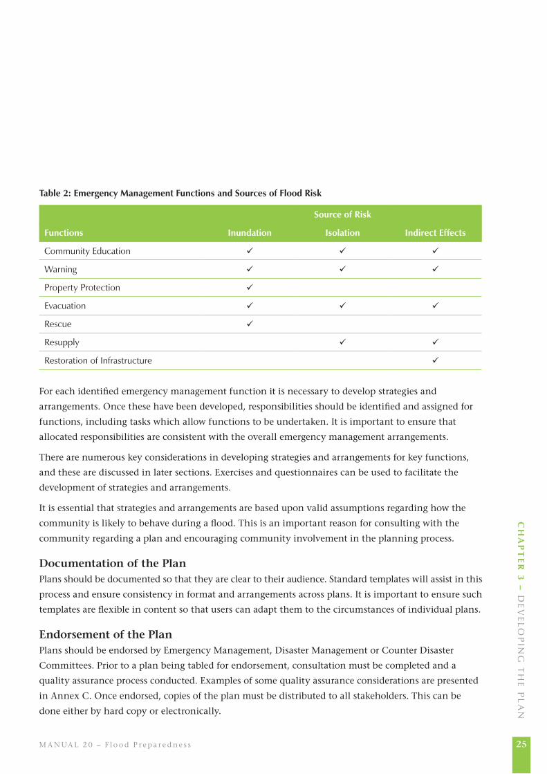
Developing Strategies and ArrangementsFor each source of risk identified, emergency management functions should be determined. Functions
that need to be dealt with for the various sources of flood risk are listed in Table 2.
25M A N UA L 2 0 – F lo o d P r e p a r e d n e s s
Ch
ap
te
r 3
– d
ev
elo
Pin
g t
he
Pl
an
table 2: emergency Management Functions and Sources of Flood risk
Source of risk
Functions Inundation Isolation Indirect effects
Community education
warning
Property Protection
evacuation
rescue
resupply
restoration of infrastructure
For each identified emergency management function it is necessary to develop strategies and
arrangements. Once these have been developed, responsibilities should be identified and assigned for
functions, including tasks which allow functions to be undertaken. It is important to ensure that
allocated responsibilities are consistent with the overall emergency management arrangements.
There are numerous key considerations in developing strategies and arrangements for key functions,
and these are discussed in later sections. Exercises and questionnaires can be used to facilitate the
development of strategies and arrangements.
It is essential that strategies and arrangements are based upon valid assumptions regarding how the
community is likely to behave during a flood. This is an important reason for consulting with the
community regarding a plan and encouraging community involvement in the planning process.
Documentation of the PlanPlans should be documented so that they are clear to their audience. Standard templates will assist in this
process and ensure consistency in format and arrangements across plans. It is important to ensure such
templates are flexible in content so that users can adapt them to the circumstances of individual plans.
Endorsement of the PlanPlans should be endorsed by Emergency Management, Disaster Management or Counter Disaster
Committees. Prior to a plan being tabled for endorsement, consultation must be completed and a
quality assurance process conducted. Examples of some quality assurance considerations are presented
in Annex C. Once endorsed, copies of the plan must be distributed to all stakeholders. This can be
done either by hard copy or electronically.
26
AU S T R A L I A N E M E R GE N C Y M A N UA L S S E R I E S
Chapter 3
Keeping Plans Alive Unless a plan is implemented regularly, either during floods or by other means, it is likely that it will
be ineffective. Any plan needs to be kept alive to ensure it remains ‘fit for purpose’. This can be done
through exercising, review, training and community engagement and education.
Exercises provide opportunities to ensure that plans are workable and effective. They can be used as
tools in plan revision, by identifying required strategies and responsibilities and inadequacies in
procedures and communication flows, and they help to educate emergency services’ personnel and
community members about emergency management arrangements.
Exercising should be conducted regularly and be varied in its content and extent since no single test
can adequately simulate all aspects of a flood response. All agencies need to be involved in the process,
practising their designated roles and responsibilities as specified in the plan. However, not all agencies
will need to be involved in every exercise.
Training helps emergency personnel to become familiar with their responsibilities and to acquire the
skills necessary to undertake them. A simple way of ensuring emergency personnel are familiar with
their responsibilities is to run briefings detailing arrangements contained within a plan.
Community education programs can also be used to promote flood emergency planning and the plans
themselves. Programs should educate the community about the contents of the plans especially
regarding the actions community members should take that are consistent with strategies outlined in
the plans. It is desirable that emergency plans are completed prior to the establishment of community
education programs to ensure the educational activities are consistent with strategies outlined within
the plans. A plan can also be used as an instrument to educate communities through providing it in
public libraries and on websites.
Arrangements for the conduct of exercises and community education should be contained within plans.
ReviewTo ensure that flood emergency plans remain relevant and accurate it is essential that they are
regularly reviewed. The arrangements in plans should be reviewed:
• aftereachfloodoperation,
• whensignificantchangesinlanduseorcommunitycharacteristicsoccur,
• whennewinformationfromstudiesregardingfloodingbecomesavailable,
• whenfloodwarningssystemsareestablishedoraltered,
• whenfloodcontrolormitigationworksareimplementedoraltered,

27M A N UA L 2 0 – F lo o d P r e p a r e d n e s s
Ch
ap
te
r 3
– d
ev
elo
Pin
g t
he
Pl
an
• whentherearechangeswhichalteragreedplanarrangements,and
• whentherearesignificantchangesinthepersonnelwhowillhavetomanageaflood.
There is no ‘right’ time frame within which reviews should be undertaken, but as a general guide it is
wise to conduct full reviews at least every three years. Partial reviews covering specific elements may
need to be undertaken more often than complete reviews.
Consultation and CommunicationCommunication and consultation are important considerations in each step of the planning process.
Communication and consultation with the community and other emergency services and government
agencies builds ownership of the provisions of flood emergency plan, creating commitment and
enhancing the effectiveness of the plan. It is essential that project planning includes effective
strategies for communication and consultation between agencies and stakeholder groups in the
community.
An important time for community consultation is immediately after a significant flood. Public
meetings at such times may provide an outlet for community anger (eg about warning quality or the
nature of agency responses), but for flood managers they also create opportunities to better understand
the community’s needs and to gather information about flood consequences, planning arrangements
and other matters.
Structure and ContentThere is no single structure or table of contents that can be prescribed for all flood emergency plans.
This is partly because of differences in the nature of flood threats from area to area and partly because
plans operating at the local, regional and state levels are likely to address somewhat different concerns.
‘Higher level’ plans will often direct planning processes at lower levels and address coordination
functions, while local plans will deal with managing particular tasks at the community level.
The following generic Community Flood Emergency Plan identifies the principal topics or themes that
should be addressed (Table 3). The degree of detail on particular themes will be dictated by individual cases.
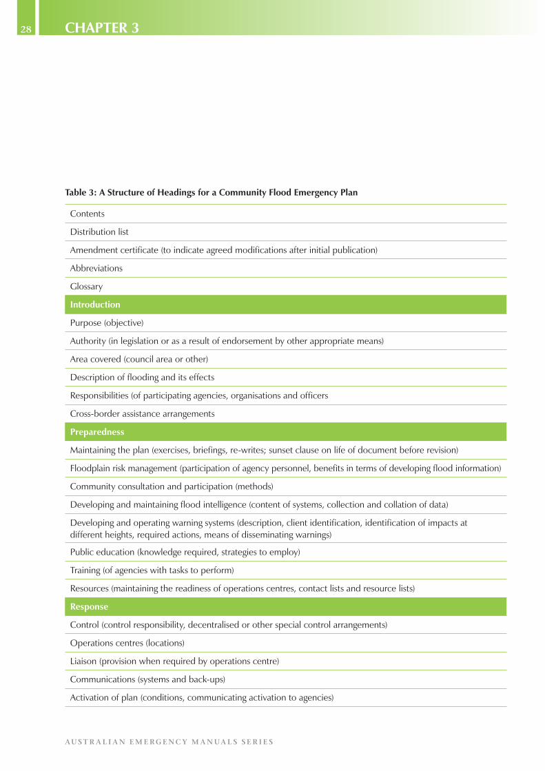
28
AU S T R A L I A N E M E R GE N C Y M A N UA L S S E R I E S
Chapter 3
table 3: a Structure of headings for a Community Flood emergency plan
Contents
distribution list
amendment certificate (to indicate agreed modifications after initial publication)
abbreviations
glossary
Introduction
Purpose (objective)
authority (in legislation or as a result of endorsement by other appropriate means)
area covered (council area or other)
description of flooding and its effects
responsibilities (of participating agencies, organisations and officers
Cross-border assistance arrangements
preparedness
maintaining the plan (exercises, briefings, re-writes; sunset clause on life of document before revision)
Floodplain risk management (participation of agency personnel, benefits in terms of developing flood information)
Community consultation and participation (methods)
developing and maintaining flood intelligence (content of systems, collection and collation of data)
developing and operating warning systems (description, client identification, identification of impacts at different heights, required actions, means of disseminating warnings)
Public education (knowledge required, strategies to employ)
training (of agencies with tasks to perform)
resources (maintaining the readiness of operations centres, contact lists and resource lists)
response
Control (control responsibility, decentralised or other special control arrangements)
operations centres (locations)
liaison (provision when required by operations centre)
Communications (systems and back-ups)
activation of plan (conditions, communicating activation to agencies)

29M A N UA L 2 0 – F lo o d P r e p a r e d n e s s
Ch
ap
te
r 3
– d
ev
elo
Pin
g t
he
Pl
an
Flood intelligence (sources, types)
Preliminary deployments (eg actions to be taken before isolation occurs)
warnings (arrangements, types, methods of dissemination)
information provision (flood bulletins, arrangements for phone-in services, inter-agency information transmission)
road control (arrangements for closures and re-openings)
Flood rescue (control, tasking, resources)
evacuation (areas possibly needing evacuation, agencies involved in doorknocking and providing assistance to evacuees, evacuation routes and centres, transport provision)
registration (evacuees)
managing animals (setting up and operating animal shelter compounds, eg for pets)
logistics (eg sandbag availability, aircraft tasking)
resupply (areas affected, arrangements for delivery of essential items)
stranded travellers (accommodation)
all clear (transmitting message)
recovery
welfare (long-term responsibility)
recovery coordination (outline of plan)
debriefing arrangements (details and recording of needed actions)
annexes
nature of the flood threat (flood types and environments, seasonality, weather systems, flood history, potential for extreme flooding)
effects of flooding on community (land uses affected, demographics, specific facilities needing attention, eg schools, hospitals, nursing homes, gaols, neighbourhood centres, utilities)
gauges monitored (list of gauges referred to)
arrangements for disseminating flood information (media and other agencies)
guide to the content of evacuation warning messages (checklist of categories of information to be provided to people before evacuation)
details of response operation arrangements for particular areas (area definition and description; institutions possibly requiring help; control arrangements eg location of forward control points; evacuation centres; evacuation routes including option sequences; traffic control points; helicopter landing points; arrangements for transporting evacuees; doorknocker requirements and agencies involved; time factors). such annexes as these should be able to be used in the field as stand-alone plans for evacuations
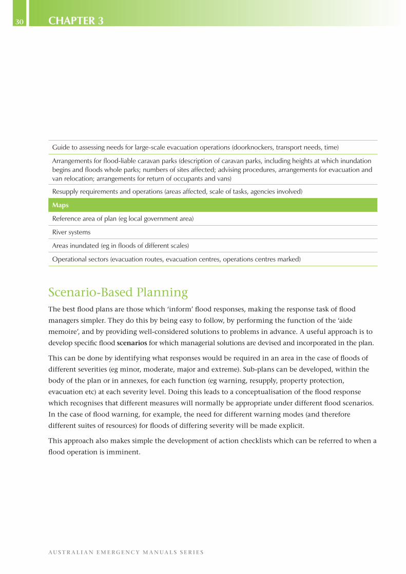
30
AU S T R A L I A N E M E R GE N C Y M A N UA L S S E R I E S
Chapter 3
guide to assessing needs for large-scale evacuation operations (doorknockers, transport needs, time)
arrangements for flood-liable caravan parks (description of caravan parks, including heights at which inundation begins and floods whole parks; numbers of sites affected; advising procedures, arrangements for evacuation and van relocation; arrangements for return of occupants and vans)
resupply requirements and operations (areas affected, scale of tasks, agencies involved)
Maps
reference area of plan (eg local government area)
river systems
areas inundated (eg in floods of different scales)
operational sectors (evacuation routes, evacuation centres, operations centres marked)
Scenario-Based PlanningThe best flood plans are those which ‘inform’ flood responses, making the response task of flood
managers simpler. They do this by being easy to follow, by performing the function of the ‘aide
memoire’, and by providing well-considered solutions to problems in advance. A useful approach is to
develop specific flood scenarios for which managerial solutions are devised and incorporated in the plan.
This can be done by identifying what responses would be required in an area in the case of floods of
different severities (eg minor, moderate, major and extreme). Sub-plans can be developed, within the
body of the plan or in annexes, for each function (eg warning, resupply, property protection,
evacuation etc) at each severity level. Doing this leads to a conceptualisation of the flood response
which recognises that different measures will normally be appropriate under different flood scenarios.
In the case of flood warning, for example, the need for different warning modes (and therefore
different suites of resources) for floods of differing severity will be made explicit.
This approach also makes simple the development of action checklists which can be referred to when a
flood operation is imminent.

31M A N UA L 2 0 – F lo o d P r e p a r e d n e s s
Ch
ap
te
r 3
– d
ev
elo
Pin
g t
he
Pl
an
Matching Managers to TasksManagement-task linkages need to be defined comprehensively. The goal in all cases must be to ensure
all foreseeable tasks will be managed by the most appropriate ‘actors’ available. Appropriateness must
be defined in terms of the relevant skills, resources or authority held by the individual (officer)
position, group or agency charged with carrying out a particular task.
In some cases, the personnel nominated to carry out tasks will not be members of emergency agencies.
They may be members, instead, of service, sporting or other special-interest clubs or community
groups.
Typically, generic responsibilities will be found in general Emergency Management or Disaster Plans.
These responsibilities can be expanded upon within the flood context in flood emergency plans.
Supporting InformationFlood emergency plans should not be regarded, in themselves, as complete descriptions of all aspects
of the management arrangements relating to flooding. Other documentation will be necessary. Most
agencies with responsibilities listed in flood emergency plans will need to develop detailed Standing
Operating (or Operational) Procedures (SOPs) to guide their intended actions in fulfilling their
responsibilities.
SOPs will, in turn, guide the training done to ensure operational readiness is maintained. In addition,
contact and resource lists will need to be developed and maintained. These should be separate from
the plan itself since they are so prone to change they can quickly render a plan obsolete.

32
AU S T R A L I A N E M E R GE N C Y M A N UA L S S E R I E S
Chapter 4
Chapter 4
Planning for specific Functions
In a Nutshell…Planning needs to be carried out on a function-by-function basis.
The key functions for which detailed planning should be undertaken are warning, evacuation,
resupply, property protection and rescue.
IntroductionThe tasks to be identified and managed during floods are, in most areas with significant flood
problems, numerous and it is not possible to deal with them all in this manual. Some guidance can be
provided, though, in terms of coverage in a plan of particular key functions, identification of
appropriate agencies to carry out particular tasks and development of solutions to problems relating to
warning provision, evacuation, resupply, rescue and property protection.
Planning Considerations for Warning and the Provision of AdviceThe creation and maintenance of flood warning systems are critical to unlocking the manageability of
the flood threat. More detail on the matters covered in this section can be found in the Australian
Emergency Manual Flood Warning.
The components of a flood warning system are the:
• predictionofseverityandtimeofonsetofflooding,
• interpretationofthepredictionusingfloodintelligencetodeterminefloodimpactsonthe
community,
• constructionofwarningmessagesdescribingwhatishappening,whatthefloodpredictionis,
what the expected impacts of the predicted flood levels will be, what actions the public should
take and who to contact for further information and emergency assistance,
• communicationofwarningmessagestothepublic,
• responsetothewarningsbyagenciesinvolvedandthecommunity,and
• reviewsofthewarningsystemafterafloodevent.
33M A N UA L 2 0 – F lo o d P r e p a r e d n e s s
Ch
ap
te
r 4
– P
la
nn
ing
Fo
r s
Pe
CiF
iC F
Un
Ct
ion
s
PredictionPredictions of flooding are provided by the Bureau of Meteorology for many river gauges and
catchments across Australia. Types of Bureau of Meteorology Flood Warning products are described on
the Bureau of Meteorology website (www.bom.gov.au). Planning considerations include the
identification of:
• theresponsibilitiesforfloodwarningprediction,
• existingfloodpredictionsystemsforfloodwarning,
• BureauofMeteorologyfloodwarningproductswhichcouldapply,
• otherpossiblewarningproducts,forexamplethosefromlocalflashfloodwarningsystems,and
• warningtimeframes.
InterpretationFlood predictions are of little value unless they are interpreted to assess the likely impacts of the
predicted flooding. Flood predictions contained in flood warnings are interpreted by reference to the
relevant flood intelligence for the warning gauge and its reference area. Planning considerations
include identification of:
• theresponsibilitiesforwarninginterpretation,
• floodintelligenceavailable,and
• sourcesofreal-timefloodintelligence.
Message ConstructionFor the community to be given the best chance of undertaking appropriate action in response to
flooding, its members must receive a flood warning message.
As far as possible, all messages should be pre-written to ensure that high quality messages can be
released in a timely manner. Note, however, that pre-written messages need to be checked in the real
time of a developing flood to ensure their relevance to the circumstances and to allow incorporation of
information which was not known before the flood operation. Pre-written warning messages should
also be reviewed when flood intelligence is updated, when the flood emergency plan is reviewed or
after a flood event.
Planning considerations include the identification of:
• theresponsibilitiesformessageconstruction,
• theappropriateadvice(calltoaction)thatshouldbeprovided,and

34
AU S T R A L I A N E M E R GE N C Y M A N UA L S S E R I E S
Chapter 4
• pre-writtenfloodbulletinsavailableandresponsibilitiesfortheirmaintenance.
CommunicationCommunication in a flood warning context involves communicating messages to those identified as
being at risk. Planning considerations include:
• identificationoftheresponsibilitiesforwarningcommunication,
• identificationoftheclientsofwarningsforvaryingmagnitudesofflooding,includingthe
number of properties and people requiring warning,
• identificationofanyspecial-needsgroups,
• identificationofresourcesavailabletoconductwarning,
• establishmentofwarningpriorities,
• identificationofarrangementsforwarningcommunicationincludingidentifyingpotential
methods of communication,
• identificationofarrangementsforuseoftheStandardEmergencyWarningSignal(SEWS),and
• establishmentofwarningsectorsforthecommunicationofwarnings.Thesearelikelytobe
based on evacuation sectors.
ReviewAfter each significant flood event, the performance and effectiveness of flood warning systems should
be evaluated. Arrangements for the review of flood warning performance and effectiveness should be
incorporated within plans.
Planning Considerations for EvacuationThe purpose of evacuation is to relocate people temporarily from areas at risk of the consequences of
flooding to places of safety. Evacuation of people may not always be the most appropriate response to
flooding, though, and it is essential to assess the risks involved in undertaking an evacuation. This will
ensure that people are not exposed to more hazardous environments as a consequence of their evacuation.
Note too that a degree of ‘spontaneous evacuation’ is likely to occur when there is sufficient warning,
without evacuation having been called for by an emergency service.

35M A N UA L 2 0 – F lo o d P r e p a r e d n e s s
Ch
ap
te
r 4
– P
la
nn
ing
Fo
r s
Pe
CiF
iC F
Un
Ct
ion
s
In some situations, evacuation planning is relatively simple and the relevant flood emergency plan will
need only a brief section on the topic to note the potential (small) scale of the task, the areas which
could be affected and the evacuation centres that would be used. In other circumstances, however, the
evacuation section may need to be considerably more detailed.
An evacuation operation is conducted as a sequential process, ideally consisting of the following five
phases:
• Decision, which involves the assessment of considerations in making a decision to evacuate
people,
• Warning, involving the development and communication of an evacuation warning,
• Withdrawal, involving the movement of people from a dangerous or potentially dangerous area
to a safer area where adequate shelter is available,
• Shelter, involving the provision of the basic needs of affected people away from the immediate
or the potential effects of flooding, and
• Return, which involves the assessment of the safety of an affected area and the return of
evacuees to their places of residence.
Prior to the development of evacuation arrangements, the following matters should be considered:
• identificationofareaslikelytorequireevacuation,
• establishmentofevacuationsectors,
• classificationoffloodplainsusingfloodplainclassificationdescriptions(seeAnnexD),
• identificationofthenumberofpeopleneedingevacuation,
• identificationofanyspecial-needsgroups,and
• identificationofwhenevacuationswillberequired.
DecisionPlanning considerations include the:
• identificationoftheauthoritytoevacuateandtheexistenceofanypowersinrelationto
‘mandating’ evacuation,
• identificationofevacuationtriggersandcompletionrestrictions(egtheclosureofevacuation
routes by floodwaters),
• identificationofevacuationpriorities,

36
AU S T R A L I A N E M E R GE N C Y M A N UA L S S E R I E S
Chapter 4
• identificationofevacuationriskstodeterminewhetherevacuationisthebestoption,
• estimationoftimeavailabletoconducttheevacuation,and
• estimationoftimelikelytobeneededtocompletetheevacuation.
WarningPlanning considerations include the identification of:
• availablepre-writtenwarningmessages,
• warningresponsibilities,
• warningcommunicationmethods,and
• arrangementsforwarningspecial-needsgroups.
WithdrawalPlanning considerations include the identification of:
• transportstrategies,
• responsibilitiesandarrangementsfortrafficcontrol,
• suitableevacuationroutes,
• responsibilitiesandarrangementsforsecurityofevacuatedareas,
• transportprovisionandarrangementsforspecial-needsgroupsandpeoplewithouttransport
(this may include a need to arrange for the movement of wheelchairs and life-support
equipment),
• responsibilitiesandarrangementsforthemovementofthecompanionanimalsandpetsof
evacuees, and of livestock, and
• deploymentofengineeringresourcesto‘shoreup’lowsectionsofroads.
ShelterPlanning considerations include identification of:
• suitableevacuationshelters,includingsufficientcapacitytoaccommodateallevacueesinflood-
free areas above PMF levels, and accessible from areas likely to be flooded. Note that this does
not mean that all evacuation shelters must be above PMF levels,
• responsibilitiesandarrangementsfortheregistrationofevacuees,
• responsibilitiesandarrangementsfortheprovisionofwelfareandsecurityforevacuees,and

37M A N UA L 2 0 – F lo o d P r e p a r e d n e s s
Ch
ap
te
r 4
– P
la
nn
ing
Fo
r s
Pe
CiF
iC F
Un
Ct
ion
s
• suitablesheltersforthepetsofevacuees.
ReturnPlanning considerations include the identification of:
• damageassessmentstrategiesandarrangements,
• criteriaforthereturnofevacuees,and
• transportarrangements.
Agencies and Organisations Potentially InvolvedMost large-scale evacuations require coordination of the efforts of numerous agencies and
organisations (sometimes including businesses and community groups). Amongst them could be:
• the Police, to ensure people do evacuate when necessary, maintain traffic flow along evacuation
routes, maintain the security of evacuated premises and areas and ensure evacuees are registered,
• other emergency service agencies, to conduct doorknocks and to assess the special needs some
evacuees are likely to have,
• councils or road-managing agencies, to close routes which may be flooded and dangerous to
use,
• transport agencies or companies, to provide appropriate modes of transport (eg buses, trains,
taxis, boats and/or aircraft) for evacuees,
• organisations to care for the livestock, pets and companion animals of evacuees, including
establishing animal shelter compounds or arranging to move farm animals out of flood reach,
• organisations or groups to help with evacuation-related tasks, such as raising or moving
furniture and commercial stock and removing or securing caravans, and
• welfare agencies, to operate reception centres outside flood affected areas so the
accommodation, clothing, food and personal requirements of evacuees can be met.
Time Considerations in Planning for EvacuationA particular concern in planning evacuation operations relates to the effective use of time. Particular
matters of concern arise if there are few access roads into and out of an area, if evacuation routes could
be cut by floodwaters before an evacuation is completed, or if islands which contain people could be
submerged before escapes can be made good.
38
AU S T R A L I A N E M E R GE N C Y M A N UA L S S E R I E S
Chapter 4
In such circumstances, where there are strict limitations on the amount of time available, the elements
of an evacuation operation can be conceptualised using a timeline (see Figure 2). In this figure, the
trigger for evacuation is taken to be the prediction of the height at which inundation occurs; in
some real cases, other motivating factors (including the loss of escape routes or the need to move
elderly people at an early stage) may be more critical.
Figure 2 illustrates the various phases into which an evacuation can be divided and forces planners to
come to grips with the scale of the evacuation task in relation to the amount of time available. Using
it, in conjunction with assessments of when evacuation routes will be cut and assumptions about
vehicular flows along escape routes, will help in the calculation of numbers of doorknockers needed,
the time by which specific groups of evacuees will need to begin their evacuation, and the phasing of
the evacuation (area by area) to prevent bottlenecking. A figure of this type can be used to determine
how to manage an evacuation operation so that everyone is moved to safety before critical moments,
such as loss of routes or onset of nightfall, are reached.
Planning Considerations for ResupplyResupply is a frequently-required function in rural areas. It can be difficult to manage because of the
geographic dispersal of those who are cut off by flooding from normal means of supply. More rarely,
resupply is necessary to whole towns, in which case the scale of the task is likely to be a problem
especially if isolation, as a result of road closures, is likely to last for a considerable length of time and
create many logistical challenges.
Resupply requirements differ depending upon the likely duration of flooding and the likelihood of
infrastructure damage.
Where prolonged isolation is identified as a possible consequence of flooding, planning for the
resupply of properties and/or communities should be undertaken. The purpose of this planning should
be to ensure that arrangements are developed to provide supplies of essential items to properties and/
or communities when they are isolated.
The initial task in developing a plan to conduct resupply is to identify areas which are likely to lose
road and/or rail access and the flood events that will result in the isolation of properties and/or
communities. For each area the following information should be identified and included in the plan:
• locationofthearea,
• keyaccessroutestotheisolatedcommunityorproperties,

39M A N UA L 2 0 – F lo o d P r e p a r e d n e s s
Ch
ap
te
r 4
– P
la
nn
ing
Fo
r s
Pe
CiF
iC F
Un
Ct
ion
s
Star
t res
pons
epl
anni
ng
Tim
e =
0
Firs
tin
dica
tions
of fl
oodi
ng
totp
tw
REa
LH
teti
tctm
Tim
e se
gmen
ts a
re n
ot d
raw
n to
sca
le
Pred
ictio
n of
inun
datio
nhe
ight
Star
tw
arni
ngSt
art
evac
uatio
nEv
acua
tion
inte
rrup
tedRe
scue
pha
se Evac
uatio
nco
mpl
eted
iftim
e av
aila
ble
Max
imum
time
befo
rein
unda
tion
Star
t war
ning
deliv
ery
Loss
of t
rans
port
rout
es/s
yste
m
P =
pre
dict
ion
calc
ulat
ion,
R =
res
pons
e in
itiat
ion,
W =
war
ning
del
iver
y, E
n =
tim
e ne
eded
to e
vacu
ate,
Ea
= ti
me
avai
labl
e to
eva
cuat
eL
= ti
me
lost
due
to fa
ilure
of e
vacu
atio
n ro
utes
/sys
tem
, H =
hea
droo
m fo
r er
ror.
Not
e: H
can
be
nega
tive
if tm
is e
arlie
r th
an tc
.
Figure 2: an evacuation timeline

40
AU S T R A L I A N E M E R GE N C Y M A N UA L S S E R I E S
Chapter 4
• locationandheights(relativetotherelevantfloodwarninggauge)atwhichkeyaccessroutes
may be closed by flooding,
• thelikelydurationofisolation,
• thesizeofcommunitiesand/orthenumberofpropertiesrequiringresupply,
• locationswherethecommunityand/orpropertiesnormallypurchasesupplies,
• whetherornotacommunityhasbusinessestomeetitsneedsorresupplythecommunity,
• whetherornotanyspecial-needsriskgroups(egfamilieswithyoungchildren)orinstitutions(eg
hospitals, clinics and nursing homes) are likely to become isolated, and
• specificresupplyneedsofpeopleandanimals(includingfarmlivestockanddomesticpetsand
companion animals).
Once the isolation problem is understood, arrangements and strategies for resupply can be developed.
Sectors should be established for areas requiring resupply. Generally each isolated area should form a
separate sector. For each sector the following should be identified and included in the plan:
• controlandcoordinationarrangements,
• locationssuitableasdistributionpointstowhichresupplyitemsaretobedeliveredfor
distribution to isolated property owners or businesses if whole communities are isolated,
• themostappropriatemethod(s)oftransporttodeliverresupplyitems,potentiallyincluding
aircraft, train, flood rescue boat or high clearance vehicle, and
• resupplyresponsibilities.
Locations from which resupply occurs are referred to as loading points. Resupply goods will be delivered
to such points by suppliers and then transported to isolated communities and/or properties. Sites for
loading points should be identified and detailed in the plan. They should be established in communities
close to isolated areas, but also close enough for normal suppliers to deliver easily to them. The choice
of loading point location will also depend upon the chosen methods of resupply delivery.
Priorities for resupply must be determined and detailed in the plan. Generally essential services should
be given the highest priority.

41M A N UA L 2 0 – F lo o d P r e p a r e d n e s s
Ch
ap
te
r 4
– P
la
nn
ing
Fo
r s
Pe
CiF
iC F
Un
Ct
ion
s
Planning Considerations for Property ProtectionThe aim of property protection is to prevent or minimise property damage through temporary means.
Two types of property require planning to prevent flood damage: public infrastructure, and business
and household contents. Methods of protection include barriers and the removal or lifting of the
contents of buildings.
The use of barriers may require the application of cost-benefit analyses to determine whether they are
economically appropriate. Such analyses, because of time constraints, are rarely possible during
responses to floods. To apply such analyses during the planning phase requires the early identification
of the locations and circumstances of potential barrier use.
BarriersTemporary barriers constructed by sandbagging, earthworks or commercial ‘wall’ barrier products can
be used to prevent water entering buildings or yards (containing, for example, essential infrastructure)
or business premises or dwellings. These methods of protection are often ineffective against large
floods, during which they may be overtopped. Sandbags must be positioned correctly to be effective.
For further information on the deployment of sandbags, see Chapter 7 of the Australian Emergency
Manual Flood Response.
Temporary barriers are suitable only for the protection of infrastructural assets and property. Such
barriers should not be used as an alternative to evacuating a community.
Removal or Lifting of ContentsDamage to building contents, essential infrastructure and equipment can be reduced or eliminated by
either lifting items or removing them to higher areas.
Key ConsiderationsThe following are key considerations to identify when developing plans for property protection:
• thepropertyrequiringprotection,includingthecriticalinfrastructurewhichneedstobe
protected,
• triggersforpropertyprotection(egforecastfloodheights),
• resourcesavailabletoconductpropertyprotection,
• timeframesavailableforconductingpropertyprotection,
• strategiesforconductingpropertyprotection(barrieregsandbagging,and/orliftingorremoval
of goods),
42
AU S T R A L I A N E M E R GE N C Y M A N UA L S S E R I E S
Chapter 4
• logisticalsupportforpropertyprotection(forbarriers:sourcesofsandbags,sandbagging
machines and sand; for removal: transport, storage facilities, management of storage facilities
and security of storage facilities), and
• responsibilitiesforpropertyprotection.
Planning Considerations for Flood RescueThe aim of flood rescue operations is to move people from immediate or potential harm to safety.
Failed evacuation operations (eg evacuation operations which have been initiated too late and have not
been completed before egress routes are lost) can result in the need for large-scale coordinated rescue
operations to take place to rescue people and animals from flood islands or inundated areas. Where the
potential need for large-scale coordinated rescue operations is identified, arrangements should be
contained within flood emergency plans. Since flood rescue is often related to evacuation
arrangements, planning for these functions should be conducted concurrently.
An understanding of the likely flood rescue problem should be established through the consideration
of the following:
• areaslikelytorequirerescue,notingthathighriskwillapplytolowfloodislands,and
• thepotentialnumberofpeoplelikelytorequirerescue,includinganyspecial-needsgroups.
Flood rescue operations can be separated into the following phases as dealt with below.
Identification and Deployment of Rescue ResourcesThis stage identifies available resources and mechanisms for their deployment.
Key planning considerations include the identification of:
• accreditedrescueunitsavailable,
• otherrescueresources(includingmaterialresources)available,
• identificationofarrangementsforthemanagementofaircraft,
• triggersforthepre-deploymentofresources.Thesetriggersshouldbebaseduponevacuation
triggers. Hence, when ordering the evacuation of a large area, an operations controller should
also consider the pre-deployment of flood rescue resources. Therefore knowledge of evacuation
triggers is required,
• areassuitableasstagingareas,includingareassuitableforthelandingofaircraft.
43M A N UA L 2 0 – F lo o d P r e p a r e d n e s s
Ch
ap
te
r 4
– P
la
nn
ing
Fo
r s
Pe
CiF
iC F
Un
Ct
ion
s
Activation of Rescue ResourcesPlanning considerations involve the identification of activation methods. Activation can occur either
through a member of the public contacting the emergency services (for example by calling 000),
through reconnaissance reports or through active searching of an area.
Rescue ExecutionThe rescue execution stage encompasses the conduct of the rescue itself. Planning considerations
include the identification of:
• themostsuitablemethods(floodrescueboat,aircraftorhigh-clearancevehicle),
• rescuesectors(thesearelikelytobealignedwithevacuationsectors),
• rescuepriorities,and
• sheltersoflastresortwherepeoplemayassembleandfromwhichtheycanberescued.
Shelter of Flood VictimsOnce people have been rescued, shelter and welfare need to be provided. Planning considerations
include the identification of:
• likelydrop-offpointswhererescuedpersonscanbetransferredtoevacuationcentresor
hospitals. These may be the same location as staging areas, but need to be located in areas where
flood-free road access is available to medical facilities and evacuation centres,
• likelyresourcesrequiredatdrop-offpointsegtransportation,registrationandambulatorycare,
• logisticssupportrequirementsforrescueresources,
• arrangementsfortheregistrationofrescuedpersons,and
• appropriateshelters.Thesearelikelytobeidentifiedinevacuationplanning.
Return of Flood VictimsOnce an ‘All Clear’ is issued, people can return to their properties. Plans should identify arrangements
for the issue of ‘All Clear’ advice. These arrangements will be common across the evacuation and
rescue functions.

44
AU S T R A L I A N E M E R GE N C Y M A N UA L S S E R I E S
Chapter 5
Chapter 5
Planning for special environmentsIn a Nutshell…Planning is often necessary for ‘special’ environments in which unique or additional considerations
have to be built in to the planning process. Amongst these are:
• areaswhichareliabletoflashflooding,
• communitieswithleveeprotection,and
• areasdownstreamofdamswhichmayfailorfromwhichwatermaybereleasedthroughgates.
Planning for Flash Flood EnvironmentsFlash floods are often sudden and unexpected and are characterised by their short warning time
frames, short duration, and often dangerous floodwaters which can cause severe damage. Flash
flooding, which is often defined as flooding which peaks within six hours of the rain which causes it,
typically results from relatively short, intense bursts of rainfall, often from thunderstorms. Generally,
such flooding is of short duration.
The ability to provide warning to people likely to be affected by flash flooding is limited. Bureau of
Meteorology warning products providing advice about potential flash flooding include Severe Weather
Warnings, Severe Thunderstorm Warnings and Flood Watches. When developing warning
arrangements for areas which are prone to flash flooding, an assessment to identify existing warning
systems should be undertaken.
Due to the limited warning time available, it is unlikely that large-scale evacuations of the floodplain
will be successful since the time required to complete evacuations in most cases will be greater than
the time available. As a consequence of the limited ability to evacuate people, there can be an
increased demand for flood rescue in flash flood areas. Limited lead times also restrict the ability for
evacuation centres to be established in a timely manner.
For the same reason, the ability to protect property in areas susceptible to flash flooding is likely to be
limited. At-risk homes, businesses and essential services at risk should be encouraged through
community education programs to be flood resilient and to develop their own means to minimise
flood damage potential.
There will be limited time to pre-deploy resources to maintain essential emergency functions.
However, unless flash flooding causes damage to roads and bridges it is unlikely that isolation
requiring resupply will be necessary.
In cases where damage to property and infrastructure has been severe it may be necessary to conduct
evacuations once floodwaters have receded.

45M A N UA L 2 0 – F lo o d P r e p a r e d n e s s
Ch
ap
te
r 5
– P
la
nn
ing
Fo
r s
Pe
Cia
l e
nv
iro
nm
en
ts
Flash flooding can affect more than one watercourse in an area at a time. Hence a separate sector for each
watercourse may need to be established, especially if transport difficulties are likely between affected areas.
Evacuation v Sheltering in PlaceEvacuation is a suitable strategy only when, by evacuating, people are not exposed to greater risks than
they would face by remaining where they are. Due to the limited warning time available and the
dangerous nature of flash flooding, in most flash flood catchments it may be more dangerous for
people to evacuate than to shelter in place (ie stay inside their building and move to the highest place).
Hazards that evacuees may be exposed to whilst evacuating are:
• floodingofevacuationroutes,
• severeweatherincludingstrongwinds,heavyrainfall,hailandlightning,
• debris,and
• fallenelectricitylines.
However, where buildings are located in floodways, it is likely that people will be exposed to high
hazard conditions in which it will be more dangerous to shelter in place than to evacuate. In these
circumstances an evacuation strategy should be adopted.
It may be appropriate for a mixed strategy to be developed, with a shelter in place strategy adopted for
buildings where evacuation is likely to be more dangerous than sheltering in place and an evacuation
strategy where evacuation is less dangerous than sheltering in place. Areas where these strategies apply
should be detailed in plans.
Planning for Flood-Prone Communities with Levee SystemsLevees are flood mitigation structures which aim to reduce flood frequency by creating a barrier between
floodwaters and community elements at risk. Levees have been used in an attempt to reduce flood
damages and enhance public safety. All levees, however, unless designed for PMF events, will ultimately
be overtopped by events larger then their design events, and in addition they may fail (despite not being
overtopped) through lack of maintenance, inadequate construction or unforeseen circumstances.
The potential for overtopping or failure means that flood emergency plans must be maintained for all
communities protected by levees, and must detail evacuation arrangements to be undertaken when
floodwaters threaten to overtop levees or cause levee failure. Communities protected by levees should
also receive ongoing community education to maintain their awareness of the flood risk, dispel any
complacency which the presence of levees has generated and promote the actions which people should
46
AU S T R A L I A N E M E R GE N C Y M A N UA L S S E R I E S
Chapter 5
take in preparing for and responding to flooding.
Planning ConsiderationsWhere levee systems are identified the following information should be contained within plans, if available:
• descriptionofeachlevee,detailinglocation,constructiontype,andthecommunitiesprotected,
• thename,identificationnumberandgaugezeroforthefloodwarninggaugerelevanttoeachlevee,
• thefollowingheightsrelativetotherelevantfloodwarninggauge,andthelikelihoodofthe
respective heights being reached:
• leveedesignheight
• overtoppingheightsofleveelowpoints
• leveespillwayheights
• imminentfailureheight,
• likelylocationsofleveeovertoppingandthesequenceofovertoppingandflooding(these
outputs may be presented in a spatial format, accompanied by a description),
• sizeofthepopulation,thenumberofresidentialandcommercialproperties,andcritical
infrastructure affected by levee over-topping or failure. This output should be expressed in
relation to a variety of flood magnitudes, including a worst-case scenario,
• theheight(relativetotherelevantfloodwarninggauge)atwhichanybackwaterflooding
commences affecting urban areas behind each levee, and the pattern of inundation,
• onceovertoppedthelengthoftimetakentofillthebasinareabehindeachleveeandthepattern
(evolution) and behaviour of inundation,
• detailsofgroundprofile(topography)insideeachleveeandtheheightofpotentialhighpoints
of land (relative to the relevant flood warning gauge),
• locationofanypartsofaleveewhichneedtobeclosedandtheheight(relativetotherelevant
flood warning gauge) at which that action must be completed by,
• knowledgeofanycriticalissuesincludingstructuralintegrityaffectingeachlevee,and
• meansofdispellinginappropriatecommunityattitudes(egfalsesensesofsecuritycreatedbythe
existence of levee protection).
It is likely that in many cases, outputs relating to overtopping and backwater flooding will vary
between floods. In these cases a description of potential flood scenarios and details of associated

47M A N UA L 2 0 – F lo o d P r e p a r e d n e s s
Ch
ap
te
r 5
– P
la
nn
ing
Fo
r s
Pe
Cia
l e
nv
iro
nm
en
ts
consequences will be required.
When new levee systems are proposed or under construction, planning authorities should encourage
the levee owner to provide the required information.
Levee HeightsThe following terms are often referred to in relation to levee heights, measured relative to a relevant
flood warning gauge:
• Imminent Failure Level: This is a level lower than the crest height of the levee and considered
to be the potential failure level of the levee.
• Design Height: The height to which a levee was designed to provide protection. Where there is a
spillway the design height should relate to the spillway level less freeboard; elsewhere it should
relate to the height of levee low points less freeboard.
• Crest Height: The crest height of a levee is equal to the design height plus freeboard.
• Spillway Height: The height of a levee’s spillway (if any).
Freeboard and Levee DesignFreeboard is the additional height added above a levee’s design height to ensure that the levee
performs at its design height. Freeboard is generally required to allow for:
• waveactionduetowind,boatsandtrucks,oftenoccurringwellafterrainhassubsided,
• localisedhydraulicaffects,whichmayresultinhigherthandesignfloodlevels,and
• inherentinaccuraciesinmodellingorhistoricfloodinformation.
Freeboard also provides a safeguard for variation between flood predictions and actual flood levels in events.
In addition to the above considerations for freeboard, the long term condition and performance of
earthen levees needs to be considered. The relevant issues are:
• post-constructionsettlement,whicheffectivelyreducesthecrestlevelofthelevee,
• trafficcrossingordrivingalongtheleveeandresultinginsurfaceerosionreducingitsheight,
• theprevalenceofdeepsurfacecrackingwhichismadeworsebydryingoutandlackof
vegetation cover, and
• theperformanceofearthenleveeswhentheyovertop.Overtoppingcanbecharacterisedby
relatively quick vertical erosion resulting in a breach which can allow more water in quickly.
This can result in flooding occurring rapidly and causing difficulties for evacuation.
48
AU S T R A L I A N E M E R GE N C Y M A N UA L S S E R I E S
Chapter 5
Since the performance of a levee cannot be assured after its design height or design specifications are
exceeded, the design height or design specifications should be used as the trigger for evacuation. For
example, if a flood prediction indicating flooding to or above the design height of a levee is received
from the Bureau of Meteorology or another credible source, evacuation would be advisable.
Note that this also means that freeboard should not be relied upon to provide community safety or be
a consideration in the decision to evacuate or not to do so. This point has been confirmed in court
proceedings in Australia, and many cases have been noted in which the freeboard originally provided
has been reduced by consolidation of levee materials or has disappeared since the levee was constructed.
Planning For Areas Downstream of DamsFlooding downstream of dams may occur as the result of the release of impounded water, either
deliberately to provide irrigation or environmental flows or unintentionally as a result of errors in gate
operation, or from dam failure or fuse plug activation. Of these, dam failure is uncommon but can be
catastrophic in its consequences.
Understanding the Dam-Failure RiskThe failure of dams results in the uncontrollable release of water, flooding downstream areas. Dam
failure can be caused by:
• floodingovertoppingadamwallorspillways,resultingintheerosionofthedam,
• earthquakesthatcausedamagetodams,resultingintheirfailure,
• pipingandseepageofwaterthroughthedamstructurethatcauseserosionofthedam,and
• humanly-inducedactionssuchasterrorismorerrorsrelatingtotheoperationordesignofadam.
Dam-failure floods are typically much larger than any previous historical floods and can occur in a
very short period of time. Downstream communities located close to dams typically have short
warning times, though in the case of dam failures caused by extreme floods passing through the dam
some downstream evacuations may have already occurred as a consequence of anticipated flooding of
rivers or creeks. However, not all the community may have been evacuated, and some people may
have become isolated as a consequence of the flooding of evacuation routes, complicating any
evacuations in anticipation of dam failure. In these cases evacuation will have to occur early before
evacuation routes are flooded.
The dam owner should supply information to the planning authority regarding the downstream
consequences of dam failure. Types of information available should include dam-break analysis

49M A N UA L 2 0 – F lo o d P r e p a r e d n e s s
Ch
ap
te
r 5
– P
la
nn
ing
Fo
r s
Pe
Cia
l e
nv
iro
nm
en
ts
reports, inundation maps and Dam Safety Emergency Plans. Information to be provided should include:
• thenatureofthedam’sdeficiencywithrespecttopotentialfloodfailureorsunny-dayfailure,
• (fordamswithaflooddeficiencyonly):theAEPoftheDamCrestFlood(DCF),
• (fordamswithaflooddeficiencyonly):adescriptionofthehydro-meteorologicalconditions
which might lead to the development of a DCF or greater flood,
• theperiodoverwhichdamfailuremightoccur,
• adescriptionofDCFconditionsdownstreamofthedam,includingtheimpactofinflowsfrom
downstream tributaries (inundation map),
• descriptionsof‘sunnydayfailure’,‘DCFwithoutdambreak’,‘DCFplusdambreak’andPMF
conditions (inundation maps),
• traveltimesforthefloodwavetoreachcriticaldownstreamlocations(indicatingboththefront
of the wave and its crest where possible),
• likelyfloodinundationdurations,and
• flowvelocitiesanddepths.
Floods that need to be considered in planning may include the following:
• Sunny Day Failure (floods caused by the unexpected failure of the dam). Such floods may
happen at any time and may not involve a rainfall event,
• Dam Crest Flood or Imminent Failure Flood (floods which raise the storage to its maximum
safe level),
• Probable Maximum Flood (the extreme flood for the catchment). Information regarding this
level of flooding is typically presented as with and without dam failure.
Planning ConsiderationsGeneral planning requirements will include:
• descriptionofthedam,
• descriptionofdam-failurescenariosanddescriptionoflikelydownstreamconsequencesand
timings,
• descriptionofanyspecialdam-failurealertingorwarningsystems,forexamplesirensor
automatic-dialling telephone systems.

50
AU S T R A L I A N E M E R GE N C Y M A N UA L S S E R I E S
Chapter 5
• arrangementsfortheestablishmentandreviewofintelligenceregardingthedownstream
consequences of dam failure (to identify/verify risk areas, action triggers, time frames and
priorities),
• arrangementsandresponsibilitiesfortheconductofcommunityeducationregardingdam
failure, and
• arrangementsandresponsibilitiesfortheestablishmentandmaintenanceofdamfailure
warning systems.
Considerations for response will include arrangements and responsibilities for:
• thewarningofat-riskcommunities,
• theevacuationofat-riskaffectedcommunities;includingtheidentificationofsuitable
evacuation routes and shelters,
• therestrictionofaccessandsecurityofevacuatedareas,
• reconnaissanceofpotentiallyaffectedareas,
• therescueoftrappedandinjuredpeople,and
• theresupplyofpotentiallyisolatedcommunities.
Considerations for recovery will include arrangements and responsibilities for the:
• initiationofrecovery,and
• conductofdebriefs.
Other Dam-Related FloodingIn addition it will sometimes be necessary to plan for ‘operational floods’ which do not involve dam
failure. Such floods may be caused or exacerbated by the deliberate or unintended release of water
through dam gates. They do not endanger the dam but may result in downstream flooding for which
special warning and/or response measures may be necessary (eg for movement of livestock or
barricading of roads).
Further detail on planning for floods caused or exacerbated by dams can be found in the Australian
Emergency Manual Emergency Management Planning for Floods Affected by Dams.
51M A N UA L 2 0 – F lo o d P r e p a r e d n e s s
Ch
ap
te
r 6
– U
sin
g e
dU
Ca
tio
n t
o in
Cr
ea
se
Co
mm
Un
ity
re
sil
ien
Ce
to
Flo
od
ing
Chapter 6
Using education to increase Community resilience to FloodingIn a Nutshell…To minimise the risks to their safety and property, it is critical that people in flood-liable areas learn
how to prepare for, respond to and recover from flood events. ‘Flood preparedness’ must include
ensuring that the people who will be affected by flooding are given the opportunity and the tools to
manage it in their own interests.
Flood education can build resilience by helping people learn about the need to be prepared for
flooding, how to prepare for floods and how to improve their ability to cope with flooding. Because
floods can occur at any time, flood education should be on-going.
Local flood education strategies are best developed, implemented, evaluated and maintained by
collectives incorporating local community representatives, local councils and emergency management
agencies. The strategies should incorporate local knowledge through consultation with local
stakeholders, as well as expertise from appropriate organisations, to deliver programs, products and
resources which are truly local in their focus.
Flood emergency plans constitute important source documents for educating communities about
floods and their management.
To maintain high levels of community readiness for flooding, a range of appropriate local delivery
and engagement methods, which target appropriate behaviour change, need to be utilised. These
should support broader social marketing projects and deliberate information-based campaigns.
The key elements of an effective community education strategy are:
• knowledgeofthelocaltargetpopulations,
• knowledgeofthelocalfloodhistoryandcurrentrisks,
• developmentofappropriatecommunityeducationmaterials,
• developmentofalocalcommunityeducationstrategywhichinvolvesthecommunityand
identifies local needs and means of delivering education to meet these needs,
• over-archingsocialmarketingbranding,messageandproductconceptswhichframelocal
delivery programs, and
• periodicreviewandevaluationofprogramelementstoensurecontinuedreach,relevanceand
effectiveness.
52
AU S T R A L I A N E M E R GE N C Y M A N UA L S S E R I E S
Chapter 6
IntroductionIt cannot be expected or assumed that all people in a flood-liable community will understand the
nature of their exposure to the flood threat or know what they should do to protect their belongings
and maintain their safety in the face of flooding. Some will be more experienced than others in
dealing with floods in their present environments, but some will have had no exposure at all. In most
areas very few people will have experienced genuinely severe floods.
Everybody, even those who have experienced several floods during their lives, will be prone to forget
what they have learned about flooding and what they can do to mitigate its effects. People will also
vary in regard to their acceptance of the risk, the degree to which their behaviour will involve the
taking of risks, their ability to respond to floods, and their knowledge, attitudes and beliefs in relation
to the flood hazard.
Even when people do have experience and/or understanding of the flood risk in their area, they may
respond inappropriately when flooding occurs. In most cases, this is manifested by under-responding
to the threat or initiating and carrying out responses later than is ideal. Often, this reflects a high
degree of complacency about the flood risk and can be associated with denial of it.
Improving Community Flood Resilience through EducationIn terms of flooding, ‘resilience’ involves the ability of the members of a community not only to
protect their interests during a flood and to recover from it afterwards, but also to learn and improve
responses as a result of the experience that a flood will provide. The aim of flood education is to
increase resilience to the flood risk by helping people and their communities to learn from, adapt to
and manage flood events.
PrinciplesFlood-ready communities must be purposefully created through:
• engagement, to create an awareness and understanding locally of the flood risk and an
understanding of the need for individuals to prepare for, respond to and recover appropriately
from floods,
• empowerment, so that people can take responsibility for and adopt appropriate actions to help
protect their own property and personal safety,
• delivery to community members of information about the tools from which appropriate
actions can be developed,
53M A N UA L 2 0 – F lo o d P r e p a r e d n e s s
Ch
ap
te
r 6
– U
sin
g e
dU
Ca
tio
n t
o in
Cr
ea
se
Co
mm
Un
ity
re
sil
ien
Ce
to
Flo
od
ing
• thecollaborative involvement of local community representatives, services and organisations
so as to build local ownership of flood management solutions and actions, and
• thepromotionoftheflexibility of services and organisations to adjust to and incorporate the
diverse and changing educational needs of the community through continual reflection on the
internal processes and structures that define why, how and when community flood education is
carried out.
Educating the members of flood-prone communities takes several forms. It can involve:
• providinginformation,sometimescharacterisedas‘one-waylearning’(egviabrochures,
displays, web pages, DVDs and the media),
• providinglearningopportunitiesby‘two-waylearning’(egbytraining,schoolcurriculum
lessons and on-line learning programs),
• buildingeducationalcapacity(bymentoringeducationalleadersanddevelopingpartnershipsfor
flood-educational purposes), and
• supportingcommunityparticipation(egindesigningandimplementingeducationalprograms
about flooding and its management).
Flood education initiatives seek to increase community resilience to the flood risk by augmenting the
ability of community members to adapt to and manage flooding. Resilience incorporates the
‘preparedness’ of a community for flooding, but also the community’s competencies and systems for
adapting to a flood and its ability to learn from flood events. ‘Community’ in this sense is inclusive of
the organisations and services responsible for flood mitigation (both infrastructure and social) and of
the individual members of the community.
Community flood education can help people and their communities build resilience to flooding in the
following ways (Dufty, 2008):
• bylearningabouttheneedtoprepare for flooding,
• bylearningwhattodobefore, during and after a flood,
• bylearninghowtoimprove systems and competencies to cope with a flood, and
• bylearning,afteraflood,waystofurther improve preparedness levels, competencies and
systems.

54
AU S T R A L I A N E M E R GE N C Y M A N UA L S S E R I E S
Chapter 6
An important first step in designing a flood education program is to understand the community’s level
of resilience, the local flood risk and the emergency planning which has been conducted. An understanding
of community resilience in relation to flooding (eg vulnerable groups, levels of preparedness,
understanding of risk and attitudes to flooding) can be obtained through different forms of social
research (eg interviews, surveys, focus groups) and from intelligence gained from previous flood
responses (including informal and anecdotal references). Understanding of flood risk and emergency
plans can be obtained from floodplain management plans and flood emergency plans respectively.
Put together, this information should help focus community flood education programs, whether they
are aimed at the community in general or at specific at-risk sectors such as businesses, caravan parks,
or the residents of a particular street.
Above all, community education initiatives must seek to persuade people that preparing for floods,
and responding to them effectively, is possible and in their own interests. They must also recognise
that people in flood-prone areas are often complacent about the risk, in denial of it or have come to
believe in myths about flooding. Such attitudes constitute barriers to learning which the designers of
educational programs should recognise and seek to overcome (see Keys, 2008, pp56-68). Ironically,
denial may be most prevalent where mitigation devices such as levees have been built. Such areas often
experience very severe flood consequences when the levees are overtopped or breached, but the levees
have given people the impression that the flood problem has been solved.
MethodsThe four types of flood education identified on p53 (Dufty, 2008) can be used to guide the design of
programs (including targeting the areas of greatest need). In some communities (especially in those
parts that are particularly vulnerable to flooding), learning about the need to prepare for flooding will
be the main type of education.
Note that increasing people’s ‘awareness’ of a flood problem is not the only way to encourage them to
prepare for flooding. Other factors in determining people’s willingness to prepare include their
understanding of flood risks and the limitations of local mitigation measures, their level of concern
about flooding, what impact they think a flood will have on them, and their perceived ability to cope
with flooding. Activities that help people learn about the need to prepare for flooding include, but
need not be limited to:
• commemorativeevents,activitiesandpromotions(displays,stalls,media–botheditorialand
advertorial – presentations, etc),
• thedevelopmentoflocallyspecificinformationproducts(brochures,inserts,hand-outs,fact
sheets, etc),

55M A N UA L 2 0 – F lo o d P r e p a r e d n e s s
Ch
ap
te
r 6
– U
sin
g e
dU
Ca
tio
n t
o in
Cr
ea
se
Co
mm
Un
ity
re
sil
ien
Ce
to
Flo
od
ing
• targeteddisplaysandengagementactivities(egdoorknocksanddemonstrations),
• schools-basedkitswhichincludefactsheetsandfloodactivitiesandarecompetency-basedon
current curriculum learning objectives,
• remindersofpastfloodevents(floodmarkers,comparativephotographs,etc),and
• thepreparationofindividualfloodplansthroughtheuseoftoolkits(egforhouseholds,
businesses and institutions.
Other educational activities that could help people and their communities improve their flood
competencies and systems include:
• trainingSESvolunteersincommunityeducation.Suchtrainingenablesvolunteerstohelp
educate their local communities in formal settings (eg events). It also produces educators on the
ground to help communities immediately before, during and after a flood,
• identifyingandtrainingcommunityleadersinfloodeducationsothattheycanhelpeducate
others in their networks,
• developingandmaintainingongoingcommunitydiscourseaboutfloodingandcopingwith
different local flooding scenarios,
• usingpublicmeetings,workinggroupsorfocusgroupstoconductcommunityandagency
reviews of preventative measures (eg floodplain management ‘devices’ such as levees) and coping
systems (eg warning systems, recovery systems),
• providingvulnerablecommunitysectors(egbusinesses),organisations(egcaravanparks)andgroups
(eg the aged, people of non-English speaking backgrounds, people who have no idea of what they
should do or do know what to do but are unable to do it at the appropriate time) with specifically
tailored educational activities to develop their competencies to cope with a flood event, and
• conductingmeetingstodiscussfloodeffectsandhowpeopleshouldrespondtocomingfloods.
Ideally, individual meetings should involve only small numbers of people.
The measures which are adopted should be recorded in flood emergency plans.
To be resilient, communities need to learn from flood events to increase their preparedness levels and
improve their capabilities. Apart from further refining the types of flood education described above,
post-flood education activities could include or make use of:
• socialresearch(egsurveysandfocusgroupdiscussions)tofindouthoweffectivethewarning,
evacuation management and recovery support systems were, how effective the past flood
education initiatives were and how these things can be improved,
56
AU S T R A L I A N E M E R GE N C Y M A N UA L S S E R I E S
Chapter 6
• agencydebriefs,thelearningfromwhichshouldbeusedtoimprovemanagementsystemsand
agency competencies,
• oralhistories,whichallowpeopletorecounttheirstoriesaboutthefloodeventandtoidentify
further opportunities to learn how to better prepare and cope with future floods, and
• communitydebriefmeetingstoidentifyproblemsinpreparation,responseandrecoveryandto
identify possible sources of improvements.
This list is not prescriptive or necessarily complete. Community education needs to be adaptive to the
needs of local communities and to explore educational options in a search for the approaches and
methods that offer sound fits.
Traditional approaches to flood education focused largely on raising ‘flood awareness’ within the
community. But awareness by itself is not sufficient to guarantee that people will act appropriately to
save belongings and maintain personal safety. Neither is the institutional belief that as ‘experts’, the
emergency services can direct people on what to do in these situations with any certainty that they
will automatically do it.
Flood education must seek a progression to a state of preparedness to act. When people have a real
sense of their exposure to the flood risk, have developed a personal understanding of what they can do
to mitigate the threat and feel supported by the emergency services, they will be more capable of
responding to warnings with appropriate actions (whether these involve avoiding particular routes on
the journey to work, stocking up on food and other essentials, lifting or relocating belongings or
evacuating their dwellings).
It also must be remembered that no matter how aware, knowledgeable and prepared people may be for
flooding, and how engaged they feel with any response process, their behaviour cannot be guaranteed when
they are placed in an actual flood situation. This is the nature of dealing with behaviour in a risk context.
Developing a Local Community Education StrategyA community flood emergency plan contains information on the threat, the problems it will pose and
the intended management of those problems. In a broad sense (though not necessarily in terms of
detail), community members need to understand this information. As a principal source document on
flooding, the plan should be made available to the community as well as being used to drive the
preparation of a community flood education strategy incorporating an engagement and delivery
strategy as well as a media strategy.
In developing a community flood education strategy, a number of practices should be included:

57M A N UA L 2 0 – F lo o d P r e p a r e d n e s s
Ch
ap
te
r 6
– U
sin
g e
dU
Ca
tio
n t
o in
Cr
ea
se
Co
mm
Un
ity
re
sil
ien
Ce
to
Flo
od
ing
• Communityfloodeducationstrategiesshouldbedevelopedinpartnershipandcollaboration
with communities to assist in the maintenance, sustainability and improvement of the
constituent educational activities.
• Programsshouldbedeliveredthroughcommunitygroups,wherebycommunitiesare
empowered to research, plan, implement and evaluate their own activities.
• EmergencyagenciessuchastheSESshouldactasconsultantstocommunities(egfacilitators,
resource providers, change agents and coordinators) rather than directing the change process in
a top-down manner.
• Opportunitiesforcross-hazard(andcross-agency)programsshouldbeidentifiedand
implemented where possible.
• Floodeducationstrategiesshouldbeincorporatedinfloodplainriskmanagementandemergency
planning processes.
• Floodeducationstrategiesshouldbelinkedtofloodwarningsystemssothatwarningscanhave
the direct effect of triggering appropriate response behaviours. This relationship should be
clearly communicated through education programs.
It is suggested that flood education strategies should have a life of no more than three years before they
are revised. Strategies should consist of:
• abackgroundexplainingthelocalfloodscenarios,communityfeaturesandapplicablewarning
services,
• thevision,outcomesandmainstrategiestoachievetheoutcomes,
• animplementationplanintabularformthatshowsthemainactivitiesforeachstrategy,atime
frame for rollout, and responsibilities and costing for each activity,
• anengagementstrategyrelevanttothelocalcommunity,and
• anevaluationplantoshowhowtheplananditsoutcomeswillbeassessedandimprovedduring
the life of the plan and at the end of the plan’s life.
Particular attention needs to be given in flood education strategies to building:
• understandingandtrustinthewarningservicesthatareprovidedandhowpeoplecanrelate
warning messages to their own circumstances,
• people’sunderstandingofwhattheyneedtodotomaintaintheirpersonalsafetyandprotect
items of importance.
58
AU S T R A L I A N E M E R GE N C Y M A N UA L S S E R I E S
Chapter 6
A flood education strategy can be a valuable tool to publicise the existence of flood threats and to
debunk the erroneous beliefs and myths which are common in flood-liable areas. These include:
• thenotionthattheveryseverefloodsseeninanareainthepastwillneverbeequalledinscale
in the future,
• thebeliefthatmitigationdevicessuchasdams,levees,diversionchannelsandretentionbasins
will render future floods harmless (in this context, building a recognition that town-protecting
levees will on occasions be overtopped is crucial), and
• theideathatfloodeducationwilldamagerealestatevalues.
The strategy’s prime purposes should be to remind people in flood-liable areas that the threat
continues to exist and to indicate to them that there are things they can do to limit the consequences
of their exposure to flooding.
The most effective flood education strategies are strongly local in content. They use local information
(eg on flood consequences at specified flood heights) and explain how local warning services operate.
They refer by name to areas which are familiar to their target audience.
The Local Flood Education Strategy CommitteeTo enable a robust and relevant education strategy to be developed, the community must be involved
with its development and implementation. By utilising or building localised community networks and
including representatives from sectors that are affected by flooding, the strategy will be more robust in
nature and will be driven at the local level. Accordingly, behaviours will have a better chance of being
adopted in local cultural norms.
A local flood education strategy committee could consist, as applicable to the community, of:
• localresidents,
• rurallandholders,
• localbusinessrepresentatives,
• representativesfromothersectorsandgroups(egschoolsandcaravanparks),
• localcouncilstaff,
• CatchmentManagementAuthoritypersonnel,
• emergencyservicespersonnel(volunteerandpaidrepresentatives),and
• otheragencystaff.
59M A N UA L 2 0 – F lo o d P r e p a r e d n e s s
Ch
ap
te
r 6
– U
sin
g e
dU
Ca
tio
n t
o in
Cr
ea
se
Co
mm
Un
ity
re
sil
ien
Ce
to
Flo
od
ing
With such a committee membership, the strategy will be seen as creating a blueprint for action for the
local community to develop, using local responses defined from within the local community.
Using the StrategyCopies of the completed community flood education strategy should be placed in council libraries and
in schools, hospitals, nursing homes and council information centres. It should also be available,
where appropriate, in non-paper form, eg on CD or on an internet home page. The strategy’s
availability should be publicised regularly in local media outlets to coincide with anniversaries of
significant events and immediately preceding the flood season (if one exists).
Developed resources (eg booklets and fact sheets) could be included in council welcome packages for
new residents and business owners as well as being promoted to sectors such as real estate and tourism.
Equally, such items could be displayed and made available from council information offices and at
council rates desks.
Potential Content ElementsIt is important to recognise that not everything which is known about flooding needs to be conveyed
to the at-risk community. Some selectivity is necessary so that people are not overwhelmed by the
information provided. The key information relates to:
• thepotentialforfloodinginthearea,
• theconsequencesoffloodingofdifferentlevelsofseverity,
• thewarningservicesthatareavailableintheareaandhowtheyshouldbeutilisedasafloodis
developing. This element is particularly important given the evidence that many people neither
understand nor trust existing warning services; in essence, they need to be educated about
warnings as well as about flooding,
• howpeoplecanplanforfloods,and
• whatindividualscandotomanagefloodingasitisdeveloping.
Delivering Flood Education: Some PointersThere is no single flood education method which can or should be employed over all others.
Community flood education needs to be diverse (as communities are) and flexible enough to
incorporate a range of program, delivery and output options. There are, however, several factors which
should guide the planning of such programs and be incorporated into community flood education
strategies. These are:
60
AU S T R A L I A N E M E R GE N C Y M A N UA L S S E R I E S
Chapter 6
• Communityeducationinvolvesdeliveringarangeofinitiativeswhichcanbelayereduponone
another. Strategies need to be broad and varied in approach. To reach a lot of people, breadth
and variety will give the benefit of repetition of messages as well as reaching out to different
parts of the community. Along with these approaches, some delivery options need to be specific
and targeted or have very specific messages tailored to different sections of a community.
Different people also learn from different sources and styles of presentation, and variation will
help maintain interest and allay boredom. It is important to maintain a varied and multi-
levelled approach to educating all members of the community about floods.
• Eventsshouldbeplannedforparticulartimesofyear,preferablyatornearthebeginningofthe
community’s flood season, if there is one, or at the time of the anniversary of a significant flood
event. It is at these times that community attention is most likely to be obtainable. Times of
drought, by contrast, are likely to be less favourable for such activities, but to avoid long periods
with no flood educational activity some initiatives may need to be undertaken during periods of
little rainfall. Flood education campaign planners must recognise that both success and cost-
effectiveness will be maximised at those times when message receptiveness is high. It is not the
convenience of agencies with responsibility for educating the community, but the likely
receptiveness of the community itself, which must be the primary driver of how and when the
educational task is undertaken.
• Mediacooperationisimportanttoprogramsuccess.Afloodcommemoration,forexample,could
be publicised by a newspaper campaign carrying articles about the community’s flood history.
Newspapers can also be encouraged to record and publish interviews with people who actually
experienced the event being commemorated, and to publish maps showing the areas which were
inundated. This campaign could also exhibit parts of the local flood emergency plan during a
council-declared ‘Flood Readiness Week’ and feature displays mounted by agencies with interests
in flood management matters. The newspaper would, in effect, be advertising and building
interest in the commemorative activity, and council support would give it further credibility. A
commemoration also provides an opportunity to publicise the flood warning services which
have been developed, the flood mitigation measures which have been adopted and the steps
which people can take to prepare for future floods: all of these themes can be taken up in
newspaper articles and in interviews on local radio stations. Extracts from the community flood
education strategy should be made available to newspapers and radio stations for use in articles
and interviews.

61M A N UA L 2 0 – F lo o d P r e p a r e d n e s s
Ch
ap
te
r 6
– U
sin
g e
dU
Ca
tio
n t
o in
Cr
ea
se
Co
mm
Un
ity
re
sil
ien
Ce
to
Flo
od
ing
• Partnershipsshouldbepurposefullycreatedbetweenemergencyservicesandotherstakeholder
organisations on the one hand and community representatives on the other. The organisations
may include local councils, the appropriate water, catchment and emergency management/
counter disaster agencies and local or regional media organisations. Attention should be given to
ensuring programs and activities are kept interesting, with appropriate variation of items and use
of modern technology in the delivery. A great deal of the experience, knowledge and resources
necessary to mount these campaigns will already be present within the community.
• Floodeducationprogramsshouldberepeatedfromtimetotimetomaintainhighlevelsof
understanding of the threat and of the warning and other arrangements which have been
devised. This is because community flood understanding will decline without periodic
reminders, and because community composition will change over time as will the content of
important documents, including the flood emergency plan. Repetition should incorporate new
and updated material and, where appropriate, revised strategies. This is vital to keep the
information fresh and relevant and to ensure it is presented in ways which compel attention.
• Wherepossible,linkswithotherhazardeducationprogramsandprocessesshouldbesought.This
is especially appropriate in rural and urban fringe areas where there may be opportunities to link with
fire authority education programs. Flood education programs would also be well linked to education
initiatives about catchment management. Such combinations will avoid duplication of effort and
will utilise combined competencies and resources. Moreover, they recognise that the community
tends to seek a ‘one-stop-shop’ for hazard education. Combined displays at events such as stalls
and community barbeques or co-presenting at community group meetings offer opportunities.
• Inallinstances,campaignsshouldbeincorporatedinthelocalfloodeducationstrategy.This
will be an effective way to design, implement and evaluate activities on an ongoing and formal
basis. The strategy should be ‘driven’ by the local flood education committee with the purpose of
creating a flood-resilient community. The key principle is to seek engagement at the local level
by local people.
• CommunityServiceAnnouncements(CSAs)aboutfloodingshouldbeplayedoverradioand
television to publicise the existence of flood problems and their management. These would highlight
the need to listen to advice given over the radio or by doorknockers and to take appropriate action
when floods are imminent. The CSAs should be no longer than 30 seconds each and should be
used just before or during the flood season or as a flood is actually rising. Newspaper equivalents
could also be devised. Stories could be developed incorporating the building of flood readiness
throughout the year and triggering the actions required to maintain a level of readiness in
the community.

62
AU S T R A L I A N E M E R GE N C Y M A N UA L S S E R I E S
Chapter 6
• Publicmeetingscouldbeheldtolaunch,discussorreviewthestrategyanditsprovisions.Such
meetings would normally be with people frequently or severely affected by flooding and could
be held in conjunction with local flood lobby or residents’ action group meetings. Engaging the
community to be active participants in the planning and development of future strategies will
give them ownership and will enable them to ‘drive’ local flood education.
• Flood markers indicating the heights reached by past floods in the area can be installed. The
markers may be plates attached to power poles or other convenient, visible and permanent
structures or specially constructed ‘totem poles’ or billboards noting the levels at which the
various historical floods peaked. These should not be ‘hidden’ from view in parks well away from
dwellings or business premises, although some business and council interests may argue against
placing them near houses and business districts for fear of negative land value effects. These
effects have been shown to be largely illusory (see Yeo, 2003). In addition the markers should
indicate the heights reached in actual past floods rather than the heights which have been
estimatedforfloodsofspecifiedannualexceedenceprobabilities(egthe5%or1%AEPfloods):
these lack realism and resonance in the minds of community members. An unveiling of the
signs could be used to publicise the risk of flooding to the community and to ‘connect’ in
people’s minds the flood heights noted with the warning services provided.
• Heightlevelsonkeygaugesforwhichfloodwarningsareprovidedareoftenlocatedatbridges
and causeways and should be clearly marked and visible from considerable distances. Such
markings help people to obtain an idea of the flood levels forecast to be reached in flood
warning messages and the areas which are likely to be inundated at those levels.
• Signageonevacuationroutesindicatingthattherouteisdesignatedtospecifiedcommunities
during flood periods can be provided.
• Information(letterbox)dropsusingfloodactionguides,informationonwarningservicesand
other printed material on floods can be valuable. These could be used for areas at high risk of
flooding, such as caravan parks on river banks or residential, commercial and industrial areas
located on low-lying floodplains. Equally, information could be made available in the form of kits
at community shows and field days or in talks given by flood managers to schools, service clubs
and other community groups. It could also be provided with council rates notices or other council
communications with ratepayers. Such information should be customised to small areas and should
focus on material which is specifically relevant to them (including maps showing the locations
of evacuation centres and any designated evacuation routes). Local known areas that are subject
to flooding should be noted. Specific information can also be translated into different languages.
63M A N UA L 2 0 – F lo o d P r e p a r e d n e s s
Ch
ap
te
r 6
– U
sin
g e
dU
Ca
tio
n t
o in
Cr
ea
se
Co
mm
Un
ity
re
sil
ien
Ce
to
Flo
od
ing
• Photographicdisplaysdepictingtheimpactofpastfloodsintheareaprovidegraphic
illustrations of the potential for flooding. Similarly, GIS outputs can be made available in
libraries and schools to illustrate the extent and depth of inundation for floods of different
severities. These need to be visually large and kept simple.
• Schoolprojectscanbeestablishedonfloodsandfloodmanagement.
• CouncilscanbeencouragedtostrikemultipleCDROMsorvideoscontainingfloodinformation,
including flood maps and plan extracts for issue or sale to the community. These could contain
footage of recent floods and commentary linking the event to the local flood emergency plan
and illustrating what people should do during future events. Videos of recent floods can help
remind people of what flooding can do and how they should respond next time.
• Internetsiteswithinformationandinteractivecomponentscanbedeveloped.
• Floodcommemorationstoremindcommunitiesaboutpastsignificantfloods,especiallythose
which occurred within the memory of the present community, can be held. Such
commemorations could incorporate:
• launchesoffloodplans,
• displays of flood photographs and other memorabilia,
• publicitybeinggiventocouncilfloodmapsandflood-relatedzoningofland,
• guidedtourstoinspectlocalmitigationsystemsincorporatingdiversionchannels
(floodways), levees and spillways,
• writtenororalbriefingsaboutwarningsystemsandhowpeoplecanusethewarnings
issued, and
• streetparadesfeaturingfloodresponseagencypersonnel.
Private Flood Emergency PlanningPrivate flood planning should be encouraged for all individuals and families in flood-liable areas as well
as for businesses, infrastructure operators and institutions (such as schools, nursing and retirement
homes, libraries, art galleries, museums, jails and churches). People should be encouraged to write
down the results of their planning and to store their plans in safe places. The plans should incorporate:
• informationonthefloodriskattherelevantdwelling,businesslocation,infrastructuralinstallation
or institution. This information should include, where possible, estimates of the conditions (eg
flood heights at the relevant flood warning gauge) in which inundation of the property and of
64
AU S T R A L I A N E M E R GE N C Y M A N UA L S S E R I E S
Chapter 6
building floors would occur and at which local evacuation routes would be inundated,
• actionsrequiredtomaintainthepersonalsafetyoftheoccupantsofthesite(including
evacuation, specifying what needs to be done in preparing for evacuation and what route should
be taken to reach safety);
• actionsrequiredtoprotectitemsofimportancesuchas:
• (indwellings):photographalbums,otherpreciousitemsofsentimentalvaluesuchas
family heirlooms, important papers and moveable furniture and furnishings, as well as
family pets,
• (inbusinesspremises):stock,recordsandcomputersandotherequipment,
• (forinfrastructuraloperators):itemsthatshouldbemoved,raisedorprotectedbyfloodbarriers,
• (ininstitutionalpremises):records,books,artworksandheritageitems,
• triggerpointsforaction(forexample,afloodwarningindicatinglikelyinundationofthe
property, or reaching floor levels, or being likely to close evacuation routes.
• remindermessagesonthedo’sanddon’tsofbehaviourduringfloods(suchasnotentering
floodwaters on foot or in vehicles).
Input for private flood plans should be obtained from community flood emergency plans, education
strategies, council and emergency services information and by conducting workshops for residents,
businesses, institutions and the operators of infrastructural assets. These workshops would seek to
prompt people to define what needs to be protected, how the protection should be achieved and how
an evacuation should be prepared for and undertaken.
Such planning can be facilitated by the provision of templates for private flood plans.
Ongoing Educational Initiatives It is important that flood education programs, using strategies of the types outlined above, be carried
out periodically to maintain and renew learning processes. They must be carefully planned to attain a
critical mass of public interest, something which can be achieved by using several different initiatives
in concert. Unlike many other types of community education that address everyday behaviours (eg
health and road safety), flood education is ‘challenged’ because floods in most parts of Australia are
not usually frequent and the time of occurrence of the next flood in a specified area cannot be known.
To be effective, flood mitigation behaviours need to be learned and then maintained over what could
be a long period of time.

65M A N UA L 2 0 – F lo o d P r e p a r e d n e s s
Ch
ap
te
r 6
– U
sin
g e
dU
Ca
tio
n t
o in
Cr
ea
se
Co
mm
Un
ity
re
sil
ien
Ce
to
Flo
od
ing
In short, communities need to continually build and maintain their competencies and systems so that
they are ‘fit for use’ when flooding occurs. Community education planning should be seen as an
ongoing endeavour, not just a single campaign.
EvaluationEvaluation should be an integral part of the local flood education plan and the campaign initiatives
which flow from it. This evaluation will inform improvements for future programs and education
activities. There are two categories of program evaluation (see Dufty, 2008). These are:
• summative evaluation, which measures the plan’s success or failure by comparing outcomes
with original goals, and
• formative evaluation, which measures the plan’s progress against ongoing benchmarks and
allows the Local Flood Education Committee to make ‘course corrections’.
Evaluation of the plans and activities should use both types of evaluation. It should strive to gauge the
appropriateness and effectiveness of the plans and the educational activities by measuring success in
the following:
• deliveryoftheplanactionsandeducationactivities,
• levelsofcommunitypreparedness,
• competenciesandsystemsinplacetoadapttoafloodevent,
• responsestofloodevents,includinguseofappropriatemitigationbehaviours,
• recoveryafterafloodevent,and
• learningsandimprovementstopreparedness,competenciesandsystemsafterafloodevent.
A major tool in this evaluation should be social research to help measure these ‘indicators of success’.
This research can include surveying of landholders and others affected by flooding, as well as holding
focus groups and debriefing meetings and recording oral histories. Anecdotal observations from
landholders, community members and emergency agencies should be useful in adding to the more
quantitative methods such as surveying.
Educating Decision MakersOther people besides those with personal interests in flood-prone areas need to understand the flood
threat and be encouraged to support the community education objective. Among the people who
should be targeted by those who are responsible for community flood education are local government
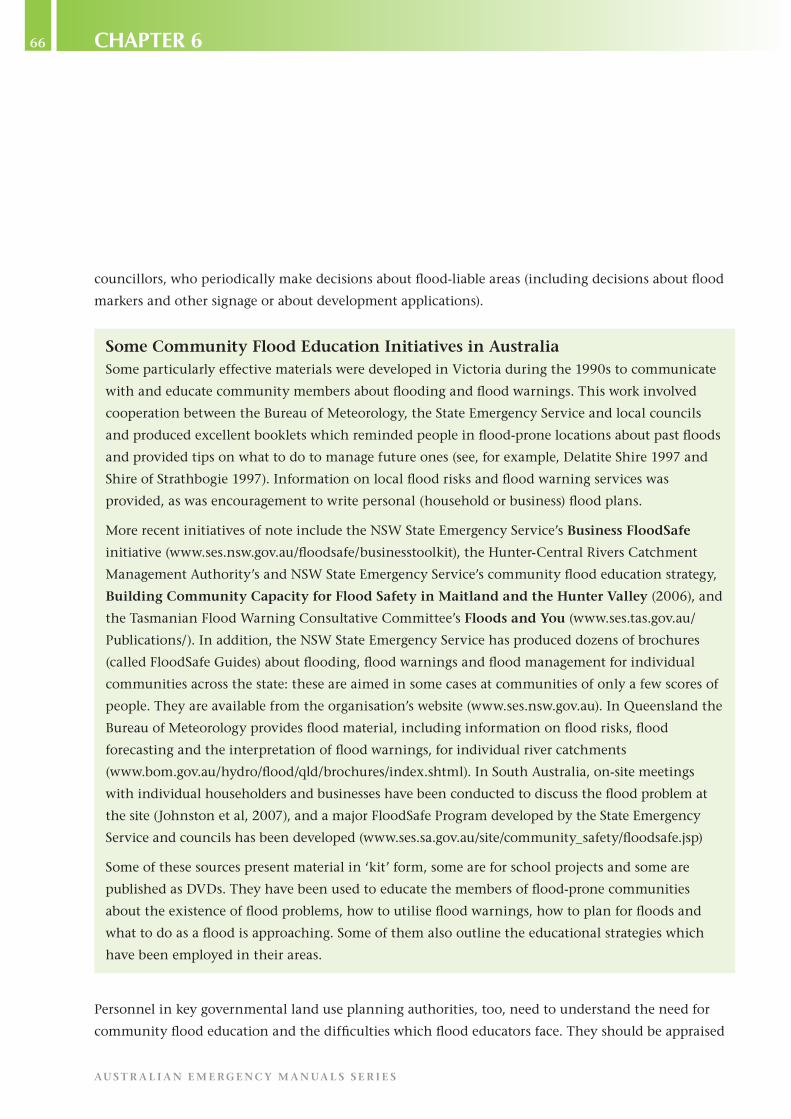
66
AU S T R A L I A N E M E R GE N C Y M A N UA L S S E R I E S
Chapter 6
councillors, who periodically make decisions about flood-liable areas (including decisions about flood
markers and other signage or about development applications).
Some Community Flood Education Initiatives in AustraliaSome particularly effective materials were developed in Victoria during the 1990s to communicate
with and educate community members about flooding and flood warnings. This work involved
cooperation between the Bureau of Meteorology, the State Emergency Service and local councils
and produced excellent booklets which reminded people in flood-prone locations about past floods
and provided tips on what to do to manage future ones (see, for example, Delatite Shire 1997 and
Shire of Strathbogie 1997). Information on local flood risks and flood warning services was
provided, as was encouragement to write personal (household or business) flood plans.
More recent initiatives of note include the NSW State Emergency Service’s Business FloodSafe
initiative (www.ses.nsw.gov.au/floodsafe/businesstoolkit), the Hunter-Central Rivers Catchment
Management Authority’s and NSW State Emergency Service’s community flood education strategy,
Building Community Capacity for Flood Safety in Maitland and the Hunter Valley (2006), and
the Tasmanian Flood Warning Consultative Committee’s Floods and You (www.ses.tas.gov.au/
Publications/). In addition, the NSW State Emergency Service has produced dozens of brochures
(called FloodSafe Guides) about flooding, flood warnings and flood management for individual
communities across the state: these are aimed in some cases at communities of only a few scores of
people. They are available from the organisation’s website (www.ses.nsw.gov.au). In Queensland the
Bureau of Meteorology provides flood material, including information on flood risks, flood
forecasting and the interpretation of flood warnings, for individual river catchments
(www.bom.gov.au/hydro/flood/qld/brochures/index.shtml). In South Australia, on-site meetings
with individual householders and businesses have been conducted to discuss the flood problem at
the site (Johnston et al, 2007), and a major FloodSafe Program developed by the State Emergency
Service and councils has been developed (www.ses.sa.gov.au/site/community_safety/floodsafe.jsp)
Some of these sources present material in ‘kit’ form, some are for school projects and some are
published as DVDs. They have been used to educate the members of flood-prone communities
about the existence of flood problems, how to utilise flood warnings, how to plan for floods and
what to do as a flood is approaching. Some of them also outline the educational strategies which
have been employed in their areas.
Personnel in key governmental land use planning authorities, too, need to understand the need for
community flood education and the difficulties which flood educators face. They should be appraised

67M A N UA L 2 0 – F lo o d P r e p a r e d n e s s
Ch
ap
te
r 6
– U
sin
g e
dU
Ca
tio
n t
o in
Cr
ea
se
Co
mm
Un
ity
re
sil
ien
Ce
to
Flo
od
ing
of new flood risk information which should be applied to future land use planning reviews and should
be made cognisant of the scale and difficulty of the flood education task.
Both these groups, if they permit excessive development in flood-liable areas, exacerbate the difficulties
involved in community flood education by increasing the vulnerability of the community and
ensuring that a larger educational task must be undertaken.
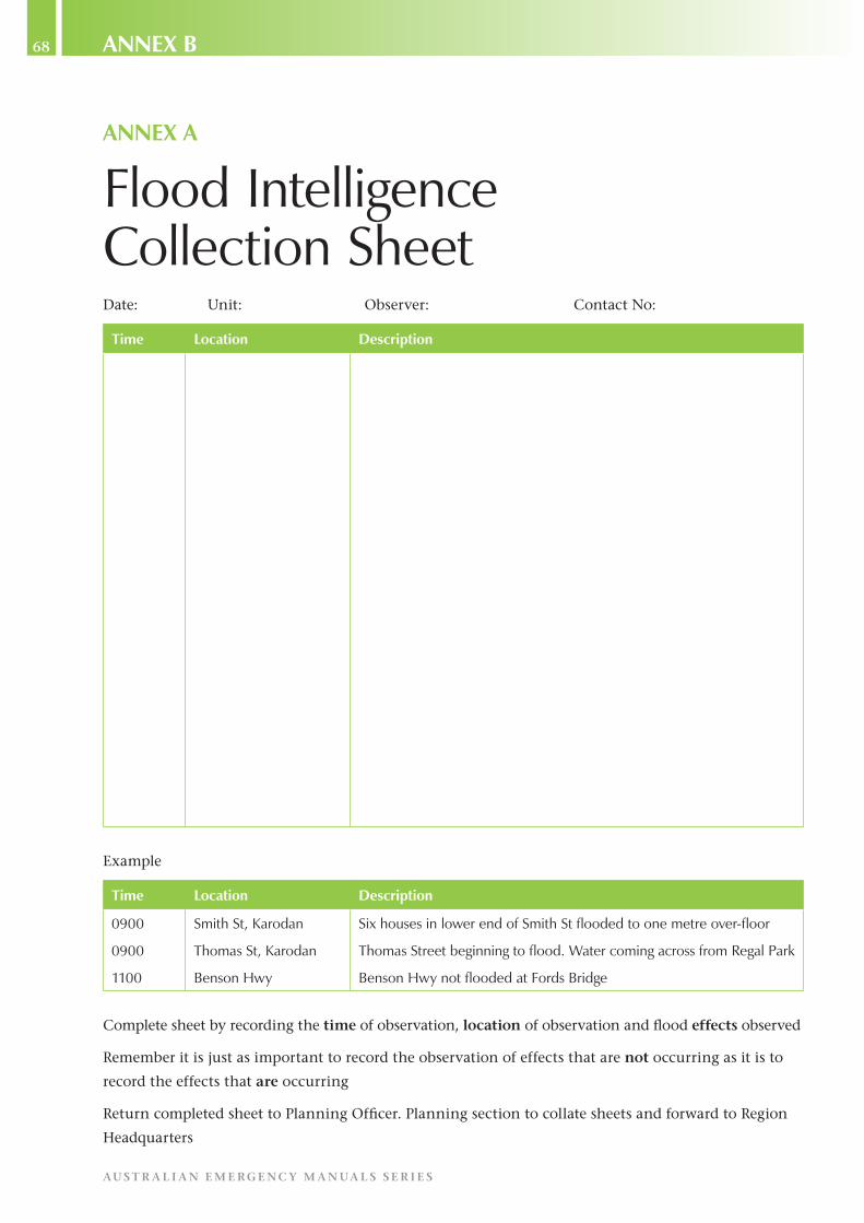
68
AU S T R A L I A N E M E R GE N C Y M A N UA L S S E R I E S
aNNex B
aNNex a
Flood intelligence Collection sheetDate: Unit: Observer: Contact No:
time Location Description
Example
time Location Description
0900
0900
1100
smith st, karodan
thomas st, karodan
Benson hwy
six houses in lower end of smith st flooded to one metre over-floor
thomas street beginning to flood. water coming across from regal Park
Benson hwy not flooded at Fords Bridge
Complete sheet by recording the time of observation, location of observation and flood effects observed
Remember it is just as important to record the observation of effects that are not occurring as it is to
record the effects that are occurring
Return completed sheet to Planning Officer. Planning section to collate sheets and forward to Region
Headquarters

69M A N UA L 2 0 – F lo o d P r e p a r e d n e s s
aN
Ne
x B
– a
sa
mP
le
Flo
od
int
el
lig
en
Ce
re
Co
rd
aNNex B
a sample Flood intelligence recordFlood Intelligence Record
Nevagazunda Gauge – Station Number: 310065
Monday, 2 February, 2009
Accuracy:
Use this information as a guide to the possible effects of a flood. The card is based on estimates of
flood behaviour and particular effects may occur at heights different from those indicated here. They
may also occur at slightly different heights in different floods.
Confidentiality:
This card may contain sensitive information about the effects of flooding on private property. Specific
reference to private addresses or businesses must be made directly to owners or other emergency
services but not via broadcast or print media.
Stream: Stopper River
Gauge Zero: 0.0m
Location: Located on the Nevagazunda Bridge over the Stopper River
Datum Type: AHD
Minor: 1.5m Moderate: 2.5m Major: 5.0m Levee Height: 5.0m
Note: The Bureau of Meteorology is generally able to predict flood heights 12 hours in advance of
major flooding at Nevagazunda.
height (m) Consequences
1.50 water starts to break out of the stopper river, flooding low-lying farmland to the south of nevagazunda. livestock and equipment need to be relocated to higher ground.
2.50 1 in 10 year flood level.
the town common is flooded. this is a popular spot for campers during the summer months and during the annual knee knockers festival held in the last week of February. at the peak of the festival, up to 1000 tent sites may be occupied.
deck height of the old bridge over kneys Creek. during flooding on the stopper river, water can back up along kneys Creek, closing this bridge and isolating up to 20 rural acreages east of nevagazunda. during past flood events, access from these properties into town has been lost for up to one week.
3.50 the nevagazunda Caravan Park is flooded. the van park has a normal occupancy of 50 people, but this can rise during peak periods to over 300. the park consists of 40 van sites, 10 of which are permanent, and 70 tent sites. note: tent sites are located close to the river bank.

70
AU S T R A L I A N E M E R GE N C Y M A N UA L S S E R I E S
aNNex B
5.0 Peak height, 3 october 1974. during this event, a flood runner crossed Bank road closing it to all traffic.
1 in 20 year flood level. this is the design height of the old nevagazunda levee. the overtopping or failure of this levee will result in over-floor flooding of 100 residential properties and approximately 40 businesses in old nevagazunda. a further 20 residences will have flooding in their yards. there is a large proportion of elderly persons living in this area.
widespread rural flooding occurs in the areas south of nevagazunda and approximately 15 rural homesteads are inundated over floor level.
5.50 Crest height of the old nevagazunda levee. the western approach to the nevagazunda bridge over the stopper river (on kings road) is now closed.
6.50 1 in 50 year flood level.
200 residential properties and 50 businesses flooded over-floor in old nevagazunda. a further 40 residences experience flooding in their yards.
water breaks out of the eastern bank of the stopper river and flows into the lower south-western part of the nevagazunda Central Business district (CBd), inundating 20 to 30 businesses premises.
the northern approach to the kneys Creek Bridge closes at the intersection of the Central highway and Bank road.
all access roads to and from the swampy heights area are now closed by floodwater except the Queens road. this road stays open until the 1% flood height (7.0 metres).
7.00 1 in 100 year flood level
Queens road is closed to all traffic. this is the last evacuation route from swampy heights. swampy heights becomes a flood island. Further river rises will result in the flooding of properties in swampy heights.
300 residential properties and 70 businesses flooded over-floor in old nevagazunda. a further 20 residences experience flooding in their yards.
extensive rural flooding downstream of nevagazunda with up to 30 rural homesteads inundated and many more isolated.
7.10 Floodwaters begin to enter swampy heights. approximately 500 properties experience flooding of their yards.
7.60 approximately 500 homes in the swampy heights area have flooding over the floor up to 0.1 metres deep.
7.80 approximately 1000 residential properties in swampy heights experience over-floor flooding up to 0.3 to 1 metre deep.
a minimum of 9 hours is required to evacuate swampy heights (assumes 28 doorknocking teams available).
9.50 90 businesses in the nevagazunda CBd are flooded over floor by this height.

71M A N UA L 2 0 – F lo o d P r e p a r e d n e s s
aN
Ne
x B
– a
sa
mP
le
Flo
od
int
el
lig
en
Ce
re
Co
rd
10.50 1 in 200 year flood level.
400 residential properties and 90 businesses flooded over-floor in old nevagazunda. 1000 residential properties experience over-floor flooding (2.8 to 3.0 metres deep) in swampy heights. 160 businesses flooded over-floor in the nevagazunda CBd.
11.20 Probable maximum Flood (PmF) level.
500 residential properties and 120 businesses flooded over-floor in old nevagazunda. 1000 residential properties flooded over-floor in swampy heights (3.5 to 3.7 metres deep). 250 businesses flooded over-floor in nevagazunda CBd.

72
AU S T R A L I A N E M E R GE N C Y M A N UA L S S E R I E S
aNNex C
aNNex C
a Checklist for vetting for QualityPreferably, evaluation of a plan should be carried out by people who have experience in emergency
management but who were not involved in writing the plan. This will help make sure the appraisal is
undertaken with appropriate detachment. The evaluation should involve an assessment of the plan’s
technical suitability to its purpose – that is, the likely effectiveness of its management provisions – and
an examination of the level of community ownership and support it has achieved and is likely to
achieve with any educational program it proposes.
Evaluating the Flood Emergency PlanEvaluation of a flood emergency plan must be rigorous. Flaws should be detected and rectified. It must
ensure the plan meets the requirement of providing ‘an organised method by which things are to be
done’, it must have a clear statement of intent and objectives, and it must be easy to read and
comprehend. In short, it must be ‘fit for purpose’.
The following checklist is not exhaustive but the flood emergency plan should be assessed against the
following criteria after preparation and periodically thereafter:
Authority: Does the plan clearly state the source of its authority?
Ownership: Is there evidence that the plan is owned and accepted by the community? Do the
members of the community know about it and understand its elements? Is there an effective program
to increase and then maintain community understanding, acceptance and ownership of the plan?
Objectives: Is the plan easy to read? Does it have a clear statement of intent and objectives?
Scope: Does the plan clearly set out its scope? Does it identify such things as any assumptions used in
its preparation, any limitations imposed on it, the range of events it has been written for and the
relationship between it and any other management plans?
Flexibility: Does the plan allow flexibility of approach so that it can meet unexpected operational
realities? Does it allow for ‘what if’ questions to be asked?
Scale: Does the plan clearly define the scale (magnitude) of the flood events it covers, with different
procedures for events of differing scale if appropriate?
Completeness: Is the plan complete in terms of coverage of foreseeable problems and identified
solutions to those problems?
Users: Does the plan clearly describe and meet the needs of the communities which are the subject of
the plan? Does it identify the user groups, those involved in the preparation and those who will have
to apply it?

73M A N UA L 2 0 – F lo o d P r e p a r e d n e s s
aN
Ne
x C
– a
Ch
eC
kl
ist
Fo
r v
et
tin
g F
or
QU
al
ity
Agencies’ Needs and Responsibilities: Does the plan meet the needs of all who will use it? Is the
relationship between different response agencies clearly spelled out? Can agencies and individuals
quickly and easily identify their areas of responsibility?
Physical Description: Does the plan contain sufficient information in words, maps, tables and
drawings about the characteristics of the area covered for an outsider to understand both the area and
the hazard without referring to other documents?
Hazard Analysis: Does the plan contain a concise statement of the results of the hazard analysis
undertaken as part of its preparation?
Community Analysis: Does the plan contain a concise analysis of the community at risk from
flooding of whatever relevant type?
Lifelines: Does the plan contain a concise analysis of community lifelines in relation to service
delivery and infrastructure support? Does it identify any vulnerabilities and propose treatments or
actions?
Activation: Does the plan clearly state the triggering processes for its activation? This should specify
who can activate the plan and what notification procedures will follow.
Management: Does the plan clearly set out the responsibilities that will prevail once the plan is
activated and who is in overall control? Does the plan detail the management systems to be used in
various phases (eg warning, response and recovery) of an event?
Review: Is there an effective review process which includes community education and involvement
and which ensures currency of the plan? Will the reviews be capable of identifying and responding to
changes in the flood threat, the community at risk and the agencies and organisations with roles to
play?
StandingOperatingProcedures(SOPs): Do the agencies listed in the plan have detailed procedures as
to how specific activities are to be undertaken or how sectors are to be managed?
Document Management: Has the plan been prepared in a practical way that allows for ease of
amendment? Is it complete with a distribution list and an amendment list? Does the plan contain a
glossary of terms that may not be known to users? Does it use appropriate practices with regard to
numbering, tracing and updating copies?
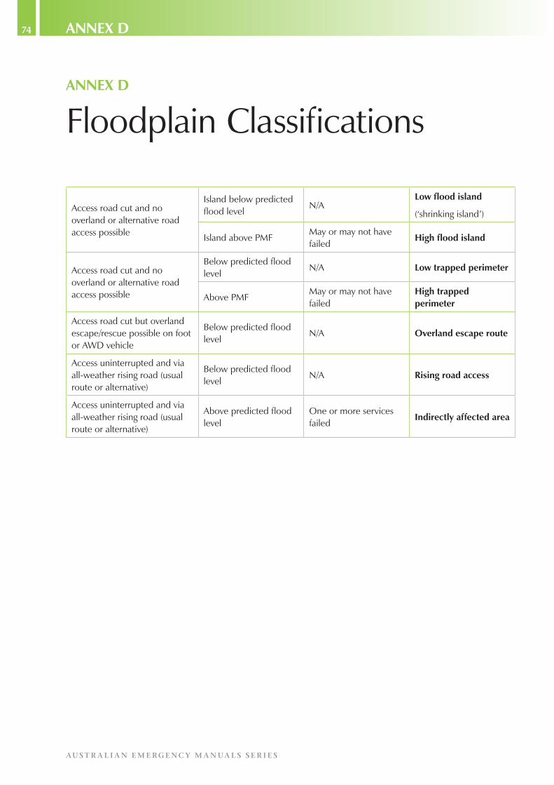
74
AU S T R A L I A N E M E R GE N C Y M A N UA L S S E R I E S
aNNex D
aNNex D
Floodplain Classifications
access road cut and no overland or alternative road access possible
island below predicted flood level
n/aLow flood island
(‘shrinking island’)
island above PmFmay or may not have failed
high flood island
access road cut and no overland or alternative road access possible
Below predicted flood level
n/a Low trapped perimeter
above PmFmay or may not have failed
high trapped perimeter
access road cut but overland escape/rescue possible on foot or awd vehicle
Below predicted flood level
n/a overland escape route
access uninterrupted and via all-weather rising road (usual route or alternative)
Below predicted flood level
n/a rising road access
access uninterrupted and via all-weather rising road (usual route or alternative)
above predicted flood level
one or more services failed
Indirectly affected area

75M A N UA L 2 0 – F lo o d P r e p a r e d n e s s
aC
ro
ny
ms
an
d g
los
sa
ry
acronyms and glossary
AEP: Annual Exceedence Probability
The chance, expressed as a percentage, of a flood equalling or exceeding a given size (usually measured
as the peak height recorded at a gauge)
ARI: Average Recurrence Interval
The long-term average length of time between floods of a specified size at a given location, expressed
in years.
CSA: Community Service Announcement
An announcement made over the electronic media, often about emergency matters and intended to be
of community benefit.
DCF: Dam Crest Flood
A flood which reaches the crest of a dam wall.
Floodplain
The land which may be covered by water when a river overflows its banks during a flood. The extent of
afloodplainwillnormallybegreaterthantheareacoveredinthe1%AEPflood,itsultimateextent
being defined by the PMF.
GIS: Geographic Information System
A computerised database for the capture, storage, analysis and display of locationally defined
information. Commonly, a GIS portrays a portion of the earth’s surface in the form of a map on which
information is overlaid.
GPS: Global Positioning System
A satellite-based navigational system used for determining location, often expressed as a peak height at
a gauge.
IFF:ImminentFailureFlood(foradam)
A flood which, if exceeded, will cause a dam to fail.
PMF: Probable Maximum Flood
An estimation of the largest flood that could occur at a particular location.
SEWS: Standard Emergency Warning Signal
A specific siren sound, designed for playing over the electronic media, to alert people to an emergency
announcement that is about to be made.
SOPs: Standing Operating Procedures.

76
AU S T R A L I A N E M E R GE N C Y M A N UA L S S E R I E S
reFereNCeS
references
Australian Emergency Manuals Series:
Manual 19 Managing the Floodplain
Manual 21 Flood Warning
Manual 22 Flood Response
Manual 23 Emergency Management Planning for Floods Affected by Dams
Bureau of Transport Economics (2001). Economic Costs of Natural Disasters in Australia, Report 103,
Canberra, Department of Transport and Regional Services.
Coates, L (1996). An Overview of Fatalities from some Natural Hazards in Australia, Proceedings of
the NDR96 Conference on Natural Disaster Reduction Heathcote, RL, Cuttler, C and Koertz, J, eds),
Surfers Paradise, pp49-59.
Crowe, P, Cinque, P and Davies, B (2003). GIS and Spatial Data in the Service of Flood Management: a
Report on an Initiative of the SES, paper presented at the 43rd annual conference of the Floodplain
Management Authorities of New South Wales, Forbes.
Delatite Shire (1997). Benalla Township and Rural Surrounds: Flood Response Guidelines.
Dufty, N (2008). A new approach to community flood education, The Australian Journal of
Emergency Management, 23 (2), pp4-8.
Hunter-Central Rivers Catchment Management Authority and New South Wales State Emergency
Service (2006). Building Community Capacity for Flood Safety in Maitland and the Hunter Valley,
Community Flood Education Strategy.
Intergovernmental Panel on Climate Change (2007). Climate Change 2007: the Physical Science
Basis, IPCC Fourth Assessment Report (Working Group 1), Geneva.
Johnston, L, Wright, C and McArthur, J (2007). Developing and Implementing a Flood Awareness and
Preparedness Programme, Journal of Business Continuity and Emergency Planning, 2 (1), pp70-81.
Keys, C (2008). Maitland, City on the Hunter: fighting floods or living with them? Hunter-Central
Rivers Catchment Management Authority, Paterson.
Leigh, R and Gissing, A (2006). How many flood prone properties are there in Australia? paper
presented at the 46th annual conference of the Floodplain Management Authorities of New South
Wales, Lismore (www.floods.org.au).
Shire of Strathbogie (1997). Euroa Township and Rural Surrounds: Flood response Guidelines for
the Community.
77M A N UA L 2 0 – F lo o d P r e p a r e d n e s s
re
Fe
re
nC
es
New South Wales State Emergency Service. Business Floodsafe (www.ses.nsw.gov.au/floodsafe/
businesstoolkit).
Standards Australia (2004). AS/NZS 460: Risk Management, SAI Global, Sydney.
Standing Committee on Agriculture and Resource Management, Agriculture and Resource
Management Council of Australia and New Zealand (2000). Floodplain Management in Australia:
Best Practice Principles and Guidelines, SCARM Report 73, CSIRO Publishing, Collingwood.
Tasmania Flood Warning Consultative Committee (2006). Floods and You (www.ses.tas.gov.au/
Publications/).
Yeo, S (2003). Effects of disclosure of flood-liability on residential property values, The Australian
Journal of Emergency Management, 18 (1), pp35-44.

78
AU S T R A L I A N E M E R GE N C Y M A N UA L S S E R I E S
reFereNCeS

AU
ST
RA
LIA
N E
ME
RG
EN
CY
MA
NU
AL
S S
ER
IES
Floo
d P
repared
ness
MA
NU
AL
20
M A N UA L 2 0
Flood Preparedness
AUS T R A L I A N E M E RGENC Y M A N UA L S SER I E Sw w w.ema .gov. au


