Topaz Solar FarmT29S, R18E, Sec. 6±8, 16±22, 27, 29; T29S, R17E, Sec. 1 San Luis Obispo County, CAMarch 2010 Environmenta l Assessment Prepared for: The County of San Luis Obispo Department of Planning and Building 976 Osos Street, Room 300 San Luis Obispo, CA 93408-2040 Prepared by: Synergy Consulting 111 Higuera Street San Luis Obispo, California 555-555-555
The following document is the Final Environmental Assessment for the TSF, and was prepared
by Synergy Consulting for the County of San Luis Obispo.
Synergy Consulting is a mutual association of two firms, LEJA Consulting and SB2
Consulting.
These two consulting firms joined together on this project to create a multidisciplinary team thathas extensive experience conducting environmental assessments and preparing environmental
impact statements in accordance with NEPA regulations. Synergy¶s management and team
members have prepared several environmental documents for solar farm projects throughout the
United States. Synergy is committed to fulfilling client needs and objectives by creating a
document that objectively informs decision makers and is legally defensible.
Using issues, concerns, and an interdisciplinary (ID) team scoping process, our firm was able to
generate and assess potential impacts associated with the three project alternatives in order to
inform decision makers, who will decide on project approval. The ID team approach utilized
matrix analyses and assessments to determine issues and concerns associated with the three
alternatives, as well as project short/ long term and cumulative impacts. Using another technique,
the ID team assessed impact areas as either positive, negative, or no impact for each alternative.
Magnitude and importance values were assigned for each impact concern to create index
numbers used to analyze and compare the alternatives.
This Environmental Assessment prepared for the proposed Topaz Solar Farm analyzes and
assesses the potentially significant environmental impacts associated with the project. This
environmental document was created using an ID team approach and identifies the project
purpose, project description, three proposed alternatives, environmental consequences, list of
document preparers, and agencies contacted. The EA is intended to assist decision makers with
project approval for the proposed TSF. The lead agency and decision maker is the County of San
Luis Obispo.
The project site is located in the Shandon-Carrizo planning area in an unincorporated area of San
Luis Obispo County. The purpose of the TSF is to harness solar energy and turn it into electricity
using photovoltaic technology. This renewable energy source assists California in meeting its
alternative energy requirements and reduction of greenhouse gases set forth in California
Assembly Bill 32 (AB 32). An EA for this project is required by NEPA guidelines because the
project involves approval and permitting from federal agencies.
Issues and concerns associated with the project were scoped using an interdisciplinary team
approach and matrix analysis for each environmental consequence. Environmental issue areas
were assessed by specialists in those respective fields. The top seven affected environments
(from matrix analysis) are assessed in this document; they include: air quality, biological
resources, hydrology and water quality, geology/soils, public utilities, transportation/traffic, and
visual resources. Other non-significant environmental consequences were purged from this
document having been addressed or mitigated during pre-project planning.
There are three project alternatives that were developed around issues, concerns, and economic
feasibility. The alternatives include: 1) The proposed 4200 acre solar farm 2) A reduced 1600
acre solar farm 3) the No Action alternative. Each alternative is assessed in regards to each of the
environmental consequences, and also for short term, long term, and cumulative impacts.
The results of the assessment conclude the following for the proposed and reduced project
alternative: 1) based on biological surveys, sensitive habitats for biological resources will be
significantly impacted from habitat loss 2) grading activities will contribute to a significant loss
of topsoil and erosion 3) water utilization will be significantly impacted due to an already over
drawn aquifer 4) scenic vistas will be significantly impacted from key observation points 5) glare
will be created by solar panel light reflection and will cause a significant impact to visual
resources. Concerns regarding air quality, water resources, public utilities, and
transportation/traffic have been assessed and determined to have no significant impacts for the
three alternatives.
Utilizing matrices to create index values to compare the three alternatives, Synergy determined
that the proposed alternative, and the preferred alternative, will have the greatest environmentalimpacts. The reduced alternative will have less significant impacts but is not the preferred
alternative due to socio-economic reasons. The No Action alternative will not have any
significant impacts to the area.
If the proposed or reduced project alternatives are chosen, an Environmental Impact Statement
Synergy Consulting has been contracted by the San Luis Obispo County Department of Planning
and Building (SLODPB) to conduct an Environmental Assessment for the proposed Topaz Solar
Farm in the Carrizo Plains. During the EA process the SLODPB was the acting Lead Agency
and primary contact for the project.The proposed project is of statewide importance and located in an area that is regulated by
various government agencies; therefore, enacting the National Environmental Policy Act
(NEPA) process to assess the project¶s affect on environmentally sensitive areas. Using a
multidisciplinary team of science specialists and NEPA experts, Synergy Consulting has
prepared this EA to determine the environmental impacts resulting from the project.
The project applicant for the TSF is First Solar LLC. The information for sections 1.0 ± 3.0 was
provided by the SLODPB.
1.1 Project Region and Area
The project area is located in the Shandon-Carrizo planning area in an unincorporated area of San Luis Obispo County. The project is just north of Highway 58 and east of Bitterwater Rd, and
approximately five miles northeast of California Valley. The project is approximately six miles
north of the Carrizo National Monument. The project site area is composed of thirty (30)
privately-owned parcels, with an approximate total area of five-thousand-three-hundred (5,300)
acres. Four-thousand-two-hundred (4,200) acres have potential for being developed into solar
power operations. The project landscape is characterized by almost level to gently sloping terrain
comprised of grasslands, agricultural fields, and wetlands. Land uses include intermittent dry
grain crop production and cattle grazing along with two single-family homes with supplemental
units. Land around the project site is used primarily for agricultural purposes. Located nearby is
the Carrizo National Monument and Soda Lake, which attract many tourists to the area. Also
within several miles of the project is California Valley.
A map of the project area is shown in Appendix A, listed as Figure A1.
1.2 Purpose and Need for Action
In order to address the issues associated with global climate change, California passed Assembly
Bill 32, which calls for a twenty (20) percent reduction of greenhouse gasses by 2020. In order to
meet that goal California needs to reduce its consumption of fossil fuel used for energy
production, and instead utilize renewable resources, such as solar and wind power, which
produce little greenhouse emissions.
The proposed solar power plant intends to help California reduce greenhouse gasses bysupplementing the State with approximately five-hundred-fifty (550) megawatts (MW) of
electricity from a renewable resource. This solar facility also helps the County of San Luis
Obispo meet its objective in obtaining energy from renewable resources as outline in the
county¶s General Plan.
The TSF proposed project is supported by the California Energy Commission. The project will
increase the amount of alternative energy supplied to PG&E, which will be distributed to areas
The following alternatives consist of the proposed action, reduced project size, and no action.
The characteristics for the proposed alternatives are presented in the following.
2.1 Alternative 1 ± Proposed Action
A Conditional Use Permit has been filed by First Solar (LLC) to build a (4,200) acre power plant
over the course of a three-year period. Four-thousand-one-hundred (4,100) acres of this site will
be used for solar array panels, roads, and operation facilities. Construction of the TSF will be
implemented in two phases. The first phase consists of site preparation and is expected to take
two months. The second phase consists of project construction and is expected to take three
years. During the construction phase up to four-hundred (400) daily workers will be on site, most
of whom will be provided private bus transport from surrounding communities. There will be
two six-acre staging areas for construction equipment and temporary offices. Hauling activities
will utilize Bitterwater Road and Highway 58. The project components include 4100 acres and
the construction of: 8.4 million solar panels in 550 arrays, 1,100 500-kilowatt inverters, 550
transformers, seven above ground lines, electrical equipment, access roads, substation andswitching yard, monitor and maintenance building, Solar Energy Learning Center, and fenced
perimeter. During operational phase there will be approximately 15 workers on site.
The energy created by the site will be fed into the power grid via PG&E¶s existing transmission
line that stretches from Kern County to Morro Bay. This transmission line runs right through the
project site and can be easily accessed by the TSF. Currently, PG&E¶s transmission line can only
accept two-hundred-ten (210) MW of electricity from the TSF, but PG&E plans to build new
transmission lines and substations to accommodate additional energy production.
2.2 Alternative 2 ± Reduced Project Size
The second alternative to the project is to reduce the project size to approximately one-thousand-
six-hundred (1,600) acres. The reason for this alternative is due to the fact that PG&E can only
accommodate up to 210MW of energy with its current transmission lines. In the event that
PG&E could not build the necessary infrastructure to accept all 550 MW of power, this
alternative would be the only feasible option. Currently, PG&E plans and contracts to build the
necessary infrastructure.
The first phase for project Alternative 2 consists of site preparation and is expected to take one
month. The second phase consists of project construction and is expected to take approximately
1.5 years. During the construction phase 160 daily workers will be on site, most of whom will be
provided private bus transport from surrounding communities. There will be a two-acre staging
area for construction equipment and temporary offices. Hauling activities will utilize Bitterwater
Road and Highway 58. The project components include one-thousand-five-hundred-sixty (1,560)acres and the construction of: 3.2 million solar panels in 210 solar arrays, 420 500-kilowatt
The energy created by the site will be fed into the power grid via PG&E¶s existing transmission
line that stretches from Kern County to Morro Bay. This transmission line rune right through the
project site and can be easily accessed by the TSF.
2.3 Alternative 3 ± No Action
The No Action alternative proposes to keep current site characteristics as is. The project site is4200 acres and is characterized by almost level to gently sloping terrain with pronounced
wetlands throughout. Land uses include intermittent dry grain crop production and cattle grazing
along with two single-family homes with supplemental units. In the past dry grain crops have
been rotated and fields left fallow every other year. This agriculture production has led to
problems with erosion, sedimentation, and disturbance of a tributary that feeds in Soda Lake.
The area is also habitat to the San Joaquin Kit Fox, Tule Elk, and Pronghorn Antelope. Scenic
vistas include uninhibited views of grasslands and wildflowers from the surrounding hillsides.
3.0 Environmental Setting
The environmental setting for this project can be found under the No Action Alternative listed
The following environmental consequences (EC) and their issues and concerns (IC) were
determined using an ID team scoping process and matrix analysis. Environmental issue areas
were assessed by specialists within the respective field. The EC covered in this document are asfollows in order: Biological Resources, Air Quality, Geology/Soils, Hydrology/Water Quality,Aesthetics, Public Utilities, and Transportation/Traffic.
Each EC gives a background to identify the environmental setting and IC associated with theissue area. The assessment conducted for each EC addresses the IC and discloses the impacts
associated with the three project alternatives. Within each alternative the short term, long term,and cumulative impacts are assessed and the impacts identified.
A summary matrix for the impact associated with each project alternative can be found inAppendix B.1.
4.1 Biological Environment
4.1.1 Biological Resources
Background: The Carrizo Plain area is the largest remaining native grassland in the State of California, and is a transition area between the Pacific Coast and the Central Valley. The
region is fairly isolated, which provides excellent habitat for many species of wildlife,including both federal and state special status species. All habitats at this site are dictated by
agricultural practices, and none remain in their natural condition.
One-hundred-nineteen (119) species and subspecies of plants were found in the project area
with seventy-seven (77) of those species native to California. These species account for sixty-five percent (65%) of total vegetation. Nine special status plant species were found to
potentially occur within the project study area; however, none were found to exist on the actualsite.
One hundred and thirty four (134) animal species occur in the project region. ThirteenDepartment of Fish and Game (DFG) Species of Special Concern (SSC) were found on the
project site, including one Federally Endangered (FE) species and one State Endangered (SE)species. These species include: Tricolored Blackbird ( Agelaius tricolor, SSC), Golden Eagle
tularensis, SSC ), McKittrick Pocket Mouse ( Perognathus inornatus neglectus, special animal ),American Badger (Taxidea taxus, SSC), and San Joaquin Kit Fox (Vulpes macrotis mutica,FE ). Pronghorn Antelope (Antilocapra Americana) and Tule Elk (Cervus elap) are recently
reintroduced species that live in the region and are monitored by CDFG. They are not listedunder FESA, CESA, nor designated as a Species of Special Concern; they are, however,
considered game mammals that are provided certain protections.
Two biological surveys were assessed to determine the impact to the biological environment:the Carrizo Solar Biological Surveys Report and the Biological Report for the Topaz Solar
Farm. It has been determined that Tule Elk, Pronghorn Antelope, and American Badger habitatloss will be at a level of significance. Due to pre-project planning, impacts to the San Joaquin
Kit Fox are not considered to be significant, and may potentially be beneficial for this species.
Impacts to the other species listed above are not considered to be significant, because effectswill be temporary throughout the construction phase.
No Action: The No Action alternative will keep the environmental setting at current baseline
conditions. Currently the most prevalent plant communities at the project site are grassland and
dry grain crops. For a majority of the wildlife, cropland provides poor habitat. When plowed or bare, there is no protective cover and food is scarce.
Pronghorn Antelope and Tule Elk habitat occupies project region. The plowed cropland allows
plentiful growth of Bindweed during the summer months, which makes the fields an importanthabitat to these species during the summer, where they forage, fawn and rest.
The Carrizo Plains area is also an important linkage and corridor area for two populations of kit fox: the Camp Roberts San Joaquin Kit Fox and the Carrizo Plain Kit Fox.
Short Term: If this site is not developed, in the near future it is likely that it will continue to
be used for agricultural land to meet the demands of the growing human population. If thiswas to happen, fields would remain fenced off to keep wildlife from consuming crops and as
a result the wildlife corridor will remain obstructed. Currently rodent and small mammal poisons are used as a form of pesticide, and would most likely continue to be utilized. These
poisons are put on and around crops, and kill both the kit fox and the two mouse species.
Long Term: The current project site is an ideal location for solar powered energy production. To keep up with the growing demands for renewable energy, this site will
probably be developed as a solar farm in the future. This would create similar impacts asthose listed under the long-term effects of the proposed action section, explained below in the
Proposed Action section.
With time it is expected that more species will become listed as special status species, thus
creating a larger impact for future projects. Agricultural practices lead to many accidentaltakes of species, such as the kit fox, which often get buried or crushed while plowing. Many
farmers also actively practice using poison on and around their crops in an effort todiscourage wildlife from consuming the crops. This also leads to the death of many special
status species, such as the kit fox and both the grasshopper and pocket mouse species. If noaction is taken, it is reasonable to believe that populations of these species will decline.
Cumulative: The total cumulative impact for the project will depend on what happens to the
project site. If no action is taken, there will be no significant impacts. Both the agricultureand alternative solar project will result in fenced off areas, impacted wildlife corridors, and
habitat loss. This may be potentially significant, but will depend on the scope of analternative project.
Proposed Action: The proposed Topaz Solar Farm will potentially affect both common andspecial status species, grassland and crop habitat, and the nesting of bird species. A fence
around the project perimeter will impact wildlife movement throughout the region, but will befitted with openings to provide kit fox passage in and out of the solar field. The proposed
project calls for native grasses to be planted on the project site. Besides reducing erosion, this
is meant to restore the current croplands to nutrient-rich grasslands and provide food andshelter to smaller animals.
Short Term: Construction activities will lead to the temporary displacement of common
animals, as well as the kit fox, badger, and both grasshopper and pocket mouse. Construction
will also disturb nesting habitat for the horned lark, lark sparrow, and burrowing owl. Initialconstruction and installation of the solar farm will likely create stress to wildlife and plant
species in the area. This stress is brought about by noise, artificial lights, human exposure,dust, and environmental disturbances. This additional stress can potentially create problems
related to wildlife reproduction.
Long Term: The installation of the solar panels in agricultural fields is expected to result inan increase in native grasslands. Native grasses are to be planted within the project area, and
over time is expected to rehabilitate the agricultural land into native grassland. This will bring more rodents, such as the McKittrick Pocket Mouse, into the area, possibly creating a
beneficial impact on the site.
A fence created around the project site will affect the wildlife corridors and movement of
wildlife within the region itself. The fence is planned to be kit fox friendly, with small passages for the kit fox to pass through. This measure would create a predator free habitat for
the kit fox inside the project area, which will ultimately boost population numbers. Since thisarea is in the kit fox movement corridor, kit foxes passing though the solar fields will have a
safe haven at which to rest. The conversion of agricultural fields to native grassland will alsolead to fewer deaths due to poison and accidental burial from plowing. This will contribute to
a positive effect for the kit fox.
American Badger, Tule Elk and Pronghorn Antelope will permanently loose 4,200 acres of
habitat for the life of the project. Summer fields used by the elk and antelope for foraging on
Bindweed and fawning will be lost, and may be damaging to the survival of these species.Studies show that the elk and antelope rarely ever cross paved roads. It is not expected that
they will cross Highway 58 away from the project area, and ultimately will suffer from lossof habitat.
Cumulative: The construction of the Topaz Solar Farm will result in permanent loss of
habitat for the Tule Elk, Pronghorn Antelope, and American Badger. Wildlife not able toadapt to the project¶s effects will likely be pushed south, where they will potentiallyencounter residential areas, ranching, and traffic. When taken into perspective with other
proposed and current projects in the area, this is likely to be detrimental to populations of these species. However, this project will restore agricultural land back to native grasslands,
Reduced Project: This alternative uses only 1,600 acres of land, leaving 2,600 acres untouched.
Short Term: Short term impacts of the Reduced Project alternative will be identical to the
short term impacts of the Proposed Project, but with a lesser magnitude.
Long Term: With the Reduced Project alternative, fewer acres of agricultural land will beused in the project site. This results in less cropland being restored to native grasslands. Thisalso will mean less predator-free habitat for the kit fox, and more potential for being plowed
or poisoned than with the Proposed Project. However, 2,600 acres of elk, antelope, and badger habitat will be preserved. Tule Elk and Pronghorn Antelope will have greater chance
of survival, as there will be more plowed fields with Bindweed available for foraging andfawning.
Large wildlife species will still have to find alternative routes of passing through the plains.The amount of wildlife corridor impacted will be less than with the Proposed Project, but
1,600 acres will still be unavailable for use.
Cumulative: The cumulative impacts of the Reduced Project alternative will be identical as
the cumulative impacts for the Proposed Project, but will be on a smaller scale. Less habitat
area will be lost initially, but the remaining 2,600 acres of untouched land may end up usedfor a future project. A future project has the potential to be more significant and cause more
damage than the Proposed Project.
4.2 Physical Environment
4.2.1 Air Quality
Background: Particulate matter (PM10 and PM2.5) and ozone are projected to be associated
with project construction activities. Currently, the County of San Luis Obispo is at non-attainment for these pollutions during certain times of year. In order to comply with federal and
state regulations the project applicant has consulted with the Air Pollution Control District to
obtain the necessary permits and adhere to air quality regulations.
The proposed project and reduced project sites were monitored with standard air quality
monitoring stations to survey the area. These methods include the California Air Resources
Board¶s (CARB) OFFROAD model and the URBEMIS model. National Ambient Air Quality
Standards (NAAQS) are followed and used as the threshold for the air quality study. On-site
fugitive dust emissions will be calculated using USEPA¶s Compilation of Air Pollutant
Emission Factors (AP-42).
No Action: Air quality remains the same as it is today. No new emitters of particulate matter or dust will be introduced into the system. No National or State standards would have to be met
with this alternative. No overall environment will be affected.
Short Term: Baseline conditions remain intact, which means no short term effects on the
overall system¶s air quality except natural effects from windswept dust that would have
already happened due to weather patterns and geography of the area.
down construction phase of the reduced project will not have any cumulative impacts that
could affect the project area or the actual site.
4.2.2 Geology/Soils
Background: The Topaz Solar Farm is a project of great magnitude. It then follows that the
project, as proposed, has potential to have impacts of great magnitude. This section will focuson the potential impacts to the soil and geologic resources of the project area during
construction and operation. The impacts will be evaluated under each alternative option. The
main objectives that will be addressed are:
y Whether the soil type and structure of the project area will be able to support the
infrastructure of the projects facilities
y Whether the project will result in significant soil erosion
y Whether the project will diminish the integrity to the soil, and
y Whether this project follows Federal and state regulations
No Action: The Environmental Setting will be based on information gathered by the County of
San Luis Obispo for the Carrizo Solar Farm Project. The baseline conditions of the soilsconsist of well-drained soils on alluvial deposits.
Short Term: As the current Land Use designation of the project site is Agriculture, the short
term use of this land would fulfill this use designation and start farming operations. This
raises concern for soil erosion, as agricultural projects need irrigation. This may lead to soil
structure degradation and increased erosion if irrigation practices are not monitored closely.
Long Term: As the population of the central coast grows the demand for energy will follow
suit. It then follows that another solar project will most likely be undertaken on the project
site. If this turns out to be the case soil erosion, soil quality degradation and grading will be
major concerns
Cumulative: Soil erosion, contamination and quality degradation are all cumulative impacts
considering short term and long term uses of the project site
Proposed Project
Short Term: Issues of the proposed project impacting soils include concerns about soil
structure and possible degradation of the structural integrity. Soil Erosion is the primary
impact concern of the proposed project. This includes loss of top soil through construction of
the project, specifically grading. The proposed project requires the balanced cut and fill of
approximately 1,200,000 cubic yards of material.
Long Term: Long term impacts of the proposed project include toxic and poisonous
contamination of the soil. Soil erosion is still a concern. The degree of loss of top soil anderosion will be evaluated
Cumulative: Considering the short and long term impacts, the main impacts that will be
addressed include soil erosion from grading, structural integrity degradation from
construction activities, loss of top soil and toxic pollution of the soil
Short Term: The short term impacts of a reduced size alternative are similar to the proposed
project alternative, however to a reduced degree. Soil structure degradation and soil erosion
are still concerns but will be to a lesser degree. Reduced grading requirements will reduce
erosion concerns.
Long Term: Toxic pollutants will still be a concern and a potential impact. Soil erosion
from terracing and grading will have potentially substantial impacts but reduced from the proposed project alternative. Loss of top soil will be observed then reduced using suitable
Best Management Practices (BPMs).
Cumulative: Considering the short and long term impacts, the observed impacts will
include soil erosion from grading, structural integrity degradation from construction
activities, loss of top soil and toxic pollution of the soil. As these impacts seem to mimic the
proposed project impacts, it should be noted that soil erosion is an exponentially incremental
problem. Therefore, this reduction on project size should result in a, favorably, exponentially
reduction in soil erosion and loss of top soil.
4.2.3 Hydrology/ Water Quality
Background: The Carrizo Plain Watershed covers an area of 414 square miles, containing an
alluvial valley with very little topography (Frio et. al., p.4.9-4). Average rainfall for the region
ranges between seven and nine inches effective uniform depth (EUD) per annum (Frio et. al.,
p.4.9-10). Ephemeral drainage networks transport runoff to Soda Lake, an interior drainage
basin that dries annually with the exception of particularly wet years. This annual drying
leaves dissolved salts behind on the lake bed causing Soda Lake to be highly alkaline and
therefore its water is unfit for human consumption or agricultural use. Channels also remain
dry for the majority of the year with unpredictable flow events. Agricultural practices in the
area, such as leaving fields fallow, has resulted in degradation of water quality and channel
structure through erosive processes (Draft Alternatives, 2010). The only reliable water supply
in the area is contained within Carrizo Plain and Paso Robles Ground Water Basins, which iscurrently utilized for human consumption and agricultural production. Total present water
demand within the Carrizo Plain Ground Water Basin is 930 acre-feet per year (AFY) which
exceeds the safe annual yield of 600 AFY (Water Planning Area #8 ± California Valley, p.8-6).
This deficit is projected to grow to an average of 700 AFY over the next twenty years due to
increased water demand (IRWM, p.B-40). Overall, the Paso Robles Ground Water Basin is
currently being exploited within its safe annual water yield of 148,094 AFY. However, the
western sub region (WPA 9a) has undergone significant declines in phreatic depth due to local
overdrawing of ground water (Water Resources, 2010). The remaining portions (WPA 9b and
WPA 9c) are not currently being over exploited (IRWM, p.B-40). The project area straddles
the boundary between these basins falling within jurisdiction of the California Valley Water
Planning Area (WPA 8) and the Shandon Water Planning Area (WPA 9c) which contain theentire Carrizo Plain Ground Water Basin and the eastern portion of the Paso Robles Ground
Water Basin respectively (IRWM, p.B-5).
The project area contains numerous surface and groundwater fed alkaline wetlands. These are
regarded to have a significant nexus with main ephemeral drainage channels connected to Soda
Lake that are considered navigable waters of the United States and are therefore subject to the
jurisdiction of the United States Army Corps of Engineers (USACE) under section 404 of the
Clean Water Act (CWA) and section 10 of the Rivers and Harbors Act, and the jurisdiction of
the Central Coast Regional Water Quality Control Board (RWQCB) under the Porter-Cologne
Water Quality Control Act (WQCA) (Revised Biological Resources Assessment, p.3-1).
No Action
Short Term: The no project alternative reflects baseline conditions currently present, asdescribed above under the ³background´ heading. As such no significant impacts are
anticipated in the short term time frame under this alternative.
Long Term: The current degraded state of ephemeral drainages in the study area, as
described in the above ³background´ heading, is anticipated to continue to worsen over time
under the ³no project´ alternative. Evaluation of this impact is based on the current rate of
degradation to channel structure and elevated total suspended sediment (TSS) and total
dissolved solids (TDS) levels during flow events as a result of erosion, as well as the
eventual deposition of these sediments in Soda Lake (Fio, et. al., p. 4.9-5). Particular values
for magnitude of these impacts are unavailable; however they have been determined as
significant and affecting navigable waters of the United States (Draft Alternatives, 2010).
The current annual deficit in the ground water budget (330 AFY) within WPA 8 described in
the above ³background´ section is expected to continue with consequences in the long term.
These include rendering local wells inactive due to annually increasing phreatic depth. This
places WPA 8 under San Luis Obispo County Resource Management System (RMS) Level
of Severity III, which calls for immediate attention towards solving the issue (IRWM, p.B-
41).
Cumulative Impacts: The ³no project´ is not anticipated to contribute any cumulative
impacts to hydrology and water resources within the study area. However, the IDT has
determined that the California Valley Solar Project already in place has set a precedent for
development of similar projects, such as the TSF, in the Carrizo Plain Area. As such, futuredevelopment of projects independent of the TSF is projected under this alternative.
Proposed Action: The solar farm is predicted to increase impervious surfaces by three percent
in project area. Resulting concentrated flow is to be controlled by draining to central
depressions in the terrain where infiltration to the aquifer is facilitated.
Short Term: Water demand during the initial three year construction activity is projected to
be 27AFY. This is for use in concrete production, worker facilities, and initial PV panel
washing (GA Attachment B, p.9). Under current conditions, ground water is being used at a
deficit of 330 acre-feet per year (AFY) on average, which has been projected to increase to
700 AFY over the next twenty years (IRWM, p.B-40). Additional water demand as a result
of the project will further exacerbate this resource already under RMS Level of Severity IIIclassification, and therefore is a significant impact (IRWM, p.B-41)
Terracing of the project site for installation of photo-voltaic (PV) arrays, grading of fill for
trenches housing in ground cables, and installation of roads may have an adverse affects on
water quality. However this is to occur over less than ten percent of the 6,200 acre project
site with 50 foot buffers to all channels considered to be navigable waters of the United
States and to be therefore under the jurisdiction of the USACE. Furthermore, silt fences and
other sediment trapping devices have been incorporated into the project implementation, and
project design includes central swales to array areas to divert potential runoff carrying high
sediment loads from ephemeral channels (Fio, et. al., p. 4.9-20). Other roads crossing over
shallow swales in the eastern project area will be bridged so sheet flow remains unimpeded
or concentrated during construction (GA Attachment B, p.7)
Long Term: Operation of the Topaz Solar Farm Facility is estimated to require 3.5 AFY
over the life of the project. This will further impact an RMS Level of Severity III resource
within WPA 8, which is significant impact (IRWM, p.B-41). However a large portion of the
water used in operation will be allowed to percolate back into the water table through
shallow swales in the center of each array. Three to seven percent of this water will be
allowed to infiltrate back into the water table, using the Maxey-Eakin method for
determining recharge. This method was developed for desert watersheds sharing similar
characteristics to the Carrizo Plain Watershed (Fio, et. al., p.4.9-36). The remaining water
will be lost through evaporative processes, which still results in a net loss of a resource
already classified as being in a critical state.
Impacts to wetland resources are determined to be insignificant as the project design has
avoided all areas deemed to fall under USACE jurisdiction (GA Attachment B, p.9).
Restoration of damaged channels described in the above ³background´ section has been
incorporated into the project, and condition over the operational phase of the project will
subsequently improve from the no project alternative (GA Attachment B, p.7).
Impervious surfaces will be increased by three percent by the proposed project design (GA
Attachment B, p.10). Greater impervious area will result in concentrated flows capable of
scouring the underlying soil. This would cause increased levels of erosion and subsequently
increased TSS in stream flow bound for Soda Lake during storm events and panel washing.
The project design mitigates these risks to an insignificant level through the creation of the
above described swales central to each array and through the planting of native bunch grasses between panels to maintain soil stability (GA Attachment B, p.10). However these swales
will need to be monitored for development of wetland features due to the low infiltration rate
of local soil which has high clay content as this may require additional delineation of wetland
resources by the USACE (Frio et. al., p.4.9-28).
At least part of the project area lies within the Federal Emergency Management Agency
(FEMA) 100-year flood plain area. This is significant and will require alteration to the
design of array and facility to be awarded FEMA Flood insurance (Frio et. al., p.4.9-10).
Cumulative: The proposed project would reinforce a precedent of allowing continued
increased utilization of ground water resources already being used beyond their sustainable
yield within WPA 8.
Impervious surface area created as a result of this project is not projected to contribute to a
cumulative impact resulting in elevated erosion rates do to internally draining swale features
Cumulative impacts to wetlands are not anticipated as the project avoids areas under USACE
jurisdiction. Features with wetland characters as described above may add to overall wetland
area if formation is facilitated within solar array swales.
Reduced Project
Short Term: Construction activity will still have a comparable water demand to the proposed project alternative at approximately 27AFY over the three year period, which has
been determined to be significant as further impacting an RMS Level of Severity III
resource. Reduced terracing and grading from a smaller project area will have a lessened
impact on local water quality, however this is a reduction of an impact already determined to
be insignificant.
Long Term: Operational water demand is estimated to be half of that under the proposed
project. Water is primarily used for washing PV panels, and therefore only half the water
required for operation of the proposed project is required for a fifty percent reduction in the
solar array area. Project design is to be maintained under this alternative at a smaller scale,
therefore water used in panel washing will be allowed to infiltrate back to the water table via
central array swales. This still further impacts a RMS Level of Severity III resource and is
therefore significant.
Impervious surface area is projected to increase by 1.5 percent with a reduced project, half
the area that would be contributed by the proposed project. Preservation of project features
in the reduced project would mitigate potential impacts in the same manner described under
the above ³proposed project´ heading and are deemed insignificant with this design.
Observation for development of wetland features would still be required.
The reduced project would eliminate areas of the site that are located within FEMA 100 Year
Flood Insurance Maps. Therefore no modifications to the project design would be required
under this alternative.
Cumulative: Cumulative impacts contributed by the reduced project alternative are the same
as those from the proposed project.
4.3 Socio-Economic Environment
4.3.1 Aesthetics
Background: The proposed Topaz Solar Project is located in San Luis Obispo County near the
northern limit of the Carrizo Plain, a highly scenic and visually intact valley comprising a
portion of the San Andreas Rift Zone. The proposed project is located within 4,365 acres of
land that is publicly recognized for its expansive beauty and lack of visual interruption or discontinuity. The site is located approximately 10 miles to the north of the Carrizo Plains
National Monument, a federally protected area, which occupies the largest portion of the valley
from Soda Lake southward. The valley floor is largely comprised of perennial and annual
grasses as well as a large variety of forbs that create a generally uniform and natural expanse.
Areas of the valley have historically been tilled and used for dry agricultural production as well
as for cattle production. The existing visual character of the project site may be tilled bare soil,
Development of ratings for the assignment of aesthetic importance values and magnitude are
based upon public issues and regulatory concerns as identified through interdisciplinary team
activities. These ratings are created in order to protect views from the intersection at Highway
58 and Bitterwater Road to the project, and to identify other potentially significant Key
Observation Points. Glare will be evaluated, including a determination of how far the glare
would be considered significant to surrounding properties and as visible from scenic views.Visual resource evaluation methodology established by the California Energy Commission for
environmental impacts caused by construction or operation of any power plant or related
facility projects will be used in conjunction with recommendations from the Agriculture and
Open Space Element as well as the Land Use Element from the County of San Luis Obispo
General Plan.
State route 58 is an east-west highway that runs across the San Joaquin Valley, The Tehachapi
Mountains, and the Mojave Dessert. The section of the highway that is affected of the
highway is at the terminal end of the highway. From SR-58 landforms are subtly defined,
there are no streams, and there are no cultural modifications of note. The only characteristic
man-made features are fence posts and the occasional remnant structures of past agricultural practices. The essential nature of the landscape in the Project¶s vicinity is that it is featureless.
Currently the highway has no designation for special status under San Luis Obispo County
planning regulations as detailed in the Land Use and Planning Element of the Shandon-Carrizo
planning guide, and therefore is not required to adhere to any legislation regarding visual
impacts in the short term. The highway however has been designated for review in the
Agriculture and Open Space Element as a road warranted for further review as to its status as a
state scenic highway, and may present impacts in the long term if such a designation is applied.
No Action Alternative
Short Term: Potential short-term impacts of the proposed project site under the no project
alternative include agricultural production of dry grains and fallowing of parcels. As the landhas been under agricultural production in the recent past, and the continued use of the land in
such a manner will not alter or impact the current visual character, there will be no
significant impact to visual resources in the short term under this alternative.
Long Term: Potential long-term impacts of the proposed project under the no project
alternative include continued agricultural production of dry grains and fallowing of parcels or
development of a similar type of solar project by another outfit. The associated impacts to
visual resources with these activities include possible interruptions to a potentially deemed
scenic highway as identified by The California Scenic Highway Program. Development of
other solar facilities within the region is likely in the long-term future due to the highly
desirable conditions present within the region, and could potentially result in impacts to
visual resources. The impact associated with other potential projects would be dependent on
the design features of the solar facility as well as the type of solar harvesting method chosen.
The impact however is considered to be less than significant due to the current non status of
the highway and because lack of design features and specifics of another similar project.
Cumulative Impacts: Potential cumulative impacts of the proposed project under the no
project alternative are the continued agricultural use and fallowing of the land, as well as the
combined impacts to visual recourses as created by development of other solar projects
(Ausra/ Carrizo Energy Solar Farm & SunPower/ California Valley Solar Ranch) within the
project region. When acknowledging the extensive environmental review and necessary
review of impact to visual resources required for these projects, the cumulative impacts have
been determined to be less than significant.
Proposed Project: As proposed by the project description, the photovoltaic solar panels will
not exceed five feet from the ground, and the use of posts driven into the ground instead of
concrete ballasts for anchoring the PV panels will reduce the amount of visual disturbance
required. Inverters will be placed in small buildings not to exceed 11 feet in height. Most of the
electrical connection between panels will be either behind the panels or underground, but
however, seven internal overhead lines on 43-foot poles are proposed. All permanent lighting
will need to be shielded from surrounding property lines. Night lighting is not expected to be
significant, due to the existing rural ³dark skies´ and no need for permanent nighttime lighting.
Short Term: Impacts to visual resources associated with construction and related activities
have a significant environmental effect. Heavy machinery and protective structures will be
necessary in the projects implementation, and have potential to create a significant effect in
the short term of project implementation. The Project site will include four separate staging
areas of approximately 10 acres each, which will be graded and fenced for security purposes.
The staging areas will include construction offices, a first aid station, worker parking, truck
loading and unloading facilities, a concrete batch plant, and an area for assembling the PV
panel support structures. These will be utilized in phases throughout the three year project
construction period. These impacts are considered as potentially significant to scenic
resources when considered in the three year construction duration due to the intrusion and
interruption of the currently intact visual resources.
Long Term: The project will potentially result in visual impacts to public views at the
intersection of Highway 58 and Bitterwater Road primarily resultant of the 4,200-acre
collective of solar panels contrasting with the present uninterrupted agricultural and rurallandscapes. The principal project design features that would affect visual resources are the
arrays of photovoltaic cells as well as facilities for power transmission, at the point of
connection to the PG&E system located to the north. Distant views from public vantages are
expected upon completion of the project, of which also afford the project with significant
impacts.
Given that all panels will be fixed and oriented in the same direction and have a reflective
aspect, there may be a high potential for significant impacts resultant of panel glare. The
highest potential for glare will arise when the sun is low, in the mornings and evenings. Glare
from reflected sunlight depends on the reflectivity of materials of panel construction, the
angle at which light hits the panels, and the position of the observer relative to the panelarrays. Night lighting is not proposed except at the office for limited task specific purposes
during construction. Most of the site will involve some grading for leveling and/or trenching.
However, due to the nearly level topography, it is not expected that cut and fill areas will
present a potentially significant impact by altering the current visual character of the site.
Cumulative: The potential cumulative impacts of the Topaz project in conjunction with
other foreseeable solar projects within the Carrizo Plain are examined here. The impacts are
particularly of interest when assessed from the combined affected viewpoints within the
Carrizo National Monument. As proposed, The Topaz project would lie beyond the
background distance zone from the Carrizo National Monument, but elevated viewpoints
within the nearby hills afford panoramic vistas that extend for many miles, and the integrity
of the CNM scenic view shed and vistas is an issue of paramount concern.
4.3.2 Public Utilities
Background: The proposed project area is located in the southeastern area of San Luis ObispoCounty, specifically in the northwest corner of the Carrizo Plains in the County¶s Shandon
Carrizo Planning Area. Despite being located on remote rural agricultural land, the projectwould be served by the San Luis Obispo County, regional, and State Services including:
y California Department of Forestry and Fire protection
y San Luis Obispo County Sheriff & California Highway Patrol
y Mercy West Hospital & Sierra Vista Regional Medical Center
y Twin Cities Hospital & Arroyo Grande Community Hospital
y Cold Canyon, Chicago Grade, and City of Paso Robles landfill
Based on current regulatory settings, the proposed project was evaluated to determine a
potential need to alter services within public utilities. Public service agencies are notified toinsure compliance. A waste management plan was developed in junction with the San Luis
Obispo County Integrated Waste Management Authority.
The California Department of Forestry and Fire Protection provides fire protection, emergency
medical and rescue services to the proposed project. CAL FIRE serves the majority of theShandon-Carrizo planning area, with stations located in California Valley-Simmler, Shandon,
La Panza, and Cuyama. Response times are considered good. CAL FIRE¶s response time mapshows it would take approximately 10 ± 20 minutes to reach the project site once a call is
received. In the event of a life threatening injury, the responding fire station can request one of the two helicopters that serve San Luis Obispo County. In addition, an air tanker squadron atPaso Robles Airport is available. Based on the County¶s fire severity map, the project is within
the high-risk area due to the susceptibility to brush and wild land fires. Fire hazard severity isdetermined by a number of factors including but not limited to: remoteness of the area,
denseness of vegetation, area circulation network, proximity to fire fighting facilities, habitattype, and degree of urbanization. For structure fires, CAL FIRE has a mutual aid agreement
with all fire protection agencies in the County.
Private companies based throughout the County provide ambulance service. Because of the
remote location of the project, response times from emergency providers are generally poor.Hospital services are provided by Twin Cities Hospital in Templeton, Arroyo Grande
Community Hospital in the City of Arroyo Grande, and French & Sierra-Vista hospital in thecity of San Luis Obispo. The closest of these facilities is approximately one and a half hours
away from the project.
The county Sheriff¶s Department provides police and patrol services. The county is divided
into three areas: North, Coast, and South. The sheriff¶s headquarters is located at theoperational facility at camp San Luis Obispo. The California Highway Patrol services San Luis
Obispo County¶s highways, with stations located in the city of San Luis Obispo as well as
Templeton. The staff is available to respond in emergency situations, but generally do notrespond to residential calls. Emergency services generally include ambulance and hospital
service. According to the Sheriff¶s Office, an adequate level of service is approximately onedeputy for every 750 people. The current ratio has not kept pace with the population growth ±
one deputy for every 1,140 people.
Trash collection and disposal can be accomplished by several methods such as: Private haulers,
individual direct haul to landfills, and illegal dumping. The county currently has three permitted public landfill facilities that accept a variety of municipal solid waste: Cold Canyon,
Chicago Grade and Paso Robles. There is one private landfill operated by the California National Guard at Camp Roberts. These landfills are under the jurisdiction of, and permitted
by, the California Integrated Waste Management Board. The applicant has stated thatapproximately 95% of the panel arrays will be recyclable through the Applicant¶s pre-paid
recycling program.
Electrical power to the area is provided via PG&E. A relationship will be established toidentify the procedure for electrical distribution.
No Action Alternative: This alternative would allow the project site to continue in its current
state and the public services elements of the project would not be affected. EnvironmentalConsequences Associated: Fire, police and emergency regulations regarding response times
and safety will remain unaltered since current parameters are appropriate for the extent of the project being developed.
Short Term: No short term impacts
Long Term: No long term impacts
Cumulative: No cumulative impacts
Proposed Project: A Conditional Use Permit has been filed by First Solar (LLC) to build the
4200-acre power plant over the course of a three-year period. 4100 acres of this site will beused for the solar array panels, roads, and operation facilities.
Local jurisdictions provide a wide range of public services including fire and police protection,
schools, and public transportation. Emergency services may need to be provided toconstruction workers (averaging 250 workers at a given time) as well as 10 permanent
employees at the site, which is located in a remote area with limited emergency services.Accidents caused by trenching, boring, or other construction activities could lead to disruptions
of service and other adverse consequences.
Short Term: This project will be introducing uses that will impact public services. Theseinclude, but are not limited to:
1. Increased potential need for fire protection
2. Increased potential need for sheriff and CHP services3. Increased potential for land use violations
Long Term: The proposed project may potentially increase part-time as well as full timeemployment requirements for the staff within the public utilities sector. Due to the potential
need for addressing additional public utilities services, additional staff may be required.
Cumulative: The proposed project may result in the alteration/addition to the staff and
services provided by the various public services in order to adequately meet the requirements
set forth by the regulatory agencies regarding public utilities. Additional energy will bedelivered to the local community provided through PG&E.
Reduced Project: The alternative to the project is to reduce the project size to approximately
1600 acres. The reason for this alternative is due to the fact that PG&E can only receive up to210MW of energy with its current transmission lines. In the event that PG&E couldn¶t build
the necessary infrastructure to accept all 550 MW of power, then this alternative would be theonly feasible option. Currently, PG&E plans and contracts to on build the necessary
infrastructure.
Impacts to public services and utilities were assessed based on foreseeable development within
the Carrizo Plains and immediate surrounding areas addressed by the service districts
identified. Public service and utility impacts resulting from the identified project alternativewill be similar to other alternatives.
Short Term: The project will result in minimal potential increase to public services
including fire protection, police protection and staff increases at local schools. Waste
management plan will still be required.
Long Term: The project will potentially result in the long-term increase of staff and servicesin the public service sector.
Cumulative: Additional staff and services may be required to meet the requirements set
forth by regulatory agencies. Alternative and renewable energy will be provided to the
community through PG&E Fire Safety, Law enforcement and Medical Services are not significantly impacted by the
different alternatives due to the nature of the service. Regulatory settings require these services
to exist regardless of the purposed project. The purposed project will potentially require these
services to alter their operations in order to adequately comply with regulatory thresholds.
Procedures in regards to waste management must follow regulations set forth by the Integrated
Waste Management Agency. A waste management plan is required regardless of which project
alternative, and therefore will not be significantly different.
Both the reduced project alternative and the proposed project alternative demonstrate minimal
significant impact to the current infrastructure. Public services & utilities, therefore, will not besignificantly impacted based on the chosen project alternatives.
4.3.3 Transportation/ Traffic
Background: The Topaz Solar Project is proposed to have its main entrance located at the
intersection of Highway 58 and Bitterwater Road in the Shandon-Carrizo planning area in San
Luis Obispo County. The County of San Luis Obispo has determined the acceptable Level of
Service (LOS) traffic standard for rural roads in this area at ³C´ or above. A LOS µC¶ roadway
is the target characteristic for urban highways and many rural road corridors and highways.
LOS µC¶: stable flow, roadways have some congestion; some barriers to passing and traffic
flow, and are comfortable driving environments for most experienced drivers. The main
corridors under consideration for implementation of this project are currently operating within
acceptable levels. The rural corridors under consideration for this project operate within LOS
µA¶: free flow, or µB¶: reasonably free flow, for eighty-percent of daytime traffic hours.Bitterwater Road and Highway 58, due to existing road conditions, contain two areas of
concern due to visually restrictive road curves and dips.
Current Transportation Setting: Highway 46 is currently undergoing a two-lane expansion inorder to create a four-lane corridor that will reduce peak flow LOS issues on the highway.
Highway 58 is a two-lane corridor with several visually restrictive sections. Other conjoiningcorridors, including Bitterwater Road, are rural roads used mainly for agricultural purposes.
The alternatives were assessed based on their impacts to Road Condition and Road Safetyassociated with the project area and region.
No Action: The project site would remain in its current state and the transportation and
circulation elements of the area would not be affected. The roads would remain at current levelof service levels of ³C´ or better. The safety of the roads will be un-altered and certain sectionsof Bitterwater road will continue to contain visual distance hazards.
Short Term Impacts: The area will continue to operate as a rural farming and open space
resource. The roads will be impacted at the current rate and traffic safety will continue to bean issue due to the characteristics of the road segments. Cal Trans will continue the
expansion of Highway 46 and be unimpeded by project related transportation.
Long Term Impacts: The roads may be used for other solar farming projects, increased
farming operations, and/or remain at current levels of use as transport corridors to the Carrizo
National Monument.Proposed Project (TSF): The TSF alternative has the potential to influence the transportationand circulation aspects of the immediate area and associated regional road connectors. The
construction phase of the project will require upwards of 400 daily workers to travel to andfrom the project site for approximately three-years and two months. The TSF design includes a
scheduled carpool system to shuttle the employees in private busses from surroundingcommunities and parking areas to lighten the impacts to road condition and decrease potential
vehicular accidents and risks associated with such increased vehicle flows. The TSF also hastwo six-acre staging areas set aside for the storage of equipment, vehicles and temporary
offices, which will reduce the amount of time equipment effects road visibility and flow. The project will require 15 persons to commute to the project area daily for the lifetime operation
of the facilities.
The social safety of public persons and employees of the Topaz Solar Farm project are the key
concern and issue with this alternative. The damage to county road conditions andcompensation for accelerated deterioration of those roads is also an issue.
Short Term Impacts: The immediate impacts of the construction phase, creation of stagingareas and transportation of workers will have an effect on the safety and impacts of
Bitterwater road, Highway 58, and Highway 46. The use of carpooling strategies and staging
areas will reduce the amount of single-passenger vehicles. The use of large equipment andtrucks to transport materials will need special consideration and use of roadways, guide cars
may be needed for transport along some section or for certain equipment.
Long Term Impacts: The proposed project will change the type of users and vehicles
accessing the site and using the connecting roadways. The project will have replacement
phases between 20 and 40 years from the first installation and similar safety and corridor issues may be a problem during replacement activities
Cumulative Impacts: The change of zoning and land uses in this area may allow for the
implementation and construction of other solar farm projects or industrial development.
Reduced Project: The RPS alternative has the potential to influence the transportation and
circulation aspects of the affected area and region. The construction of a smaller solar farmwould reduce the amount of daily workers to 160; all will still require transportation to and
from the site either in private vehicles or using similar methods of transport included in theTSF project. The staging areas may be reduced to one main staging zone with a larger overall
size and offering the same benefits as associated in the TPS alternative. The RPS will also
reduce the amount of workers transporting to and from site to 10 for the long-term life andoperation of the project.
Affects of this reduced project on the safety and condition of the roads in and around the
project area will be minimal. The use of carpooling strategies and designated drivers that areknowledgeable about the roads and certain issue areas of transportation corridors will increase
the safety of transportation associated with the project. The use of only one staging area willreduce the impacts of the construction phase and lessen the complexity of roadway flow.
Short Term Impacts: Construction phases of the project will be the most dangerous andimpactful phase of the solar project. Installing a smaller solar farm complex will reduce the
amount of traffic, materials to be transported and workers needing to commute to and from
the site. The reduction in project size will reduce short-term impacts on safety at staging areaentrances and exits.
Long Term Impacts: The reduced solar farm will require less permanent employees to
maintain the facilities and reduce the transportation impacts of the project. The need for material replacement and recycling of solar panels will induce similar impacts to those
assessed in construction phases and will impact the traffic on the rural connector andhighway corridors.
Cumulative Impacts: The increased traffic flows on the rural roads may impact the LOS
rating to below county established ³C´ thresholds. The use of carpooling, staging areas,
alternative transport timing techniques transporting materials in low flow times, and
preparing drivers for issue areas on the corridors, will reduce the cumulative impacts of the
project. The construction phase will have the largest impact on the roads with minimal
impacts occurring for the operational phases of the project.
Due to elements included in the TSF project that incorporate carpooling opportunities and
staging area development, issues and concerns related to transportation and traffic will not be
significantly impacted. This was determined using URBEMIS modeling, agency information
and relevant documents. The RPS alternative would reduce the impacts of traffic, but the
impacts are already below significant thresholds. The level of service on the roads will be
improved due to the expansion of Highway 46. After the construction phase of the project little
impact will be felt by users of corridors associated with the project.
4.4 Summary of Environmental Impact Assessment
According to the assessment for the EC the project will have significant impacts to the following
areas: 1) sensitive habitats for biological resources due to habitat loss 2) topsoil loss and erosionresulting from grading activities 3) Water utilization because the current aquifer, or water source,is over exploited 4) Uninterrupted views to scenic vistas and key observation points will be
impacted by solar arrays and subsequent glare.
Through impact analysis and assessment the following EC were determined to have non-
significant impacts through an ID team analysis found in Appendix B.1, and they are: 1) air quality 2) public ut ilities 3) transportation/ traffic.
Index values regarding project impacts were assigned to each of the three alternatives. Theseindex numbers represent the magnitude of significant impacts associated with each project
alternative. Index numbers that have the greatest negative value represent the most significant
impacts. The index numbers for the three alternatives are as follows: No action = -33; Proposed project = -120; Reduced project = -88. From the matrix analysis it was determined that the proposed project will have the greatest significant environmental impacts. The proposed project
alternative is preferred for socio-economic reasons.
4.4.1 Project Opportunities
Using the matrix analysis and index numbers for the alternatives comparison (Appendix B.1),
Synergy has identified issue areas that have the greatest impacts. The project applicant has an
opportunity to re-evaluate these EC areas in order to minimize the significant impacts and obtain
Carmen Torres-Sibille, Ana. "Aesthetic Impact Assessment of Solar Power Plants: An Objectiveand a Subjective Approach." Renewable and Sustainable Energy Reviews13.5 (2009):
986-99.Science Direct . June 2009. Web. 23 Feb. 2010.
Cypher, Brian L., and Christine L. Van Horn Job. "Permeable Fence and Wall Designs that
Facilitate Passage by Endangered San Joaquin Kit Foxes." Topaz Solar Farm
Environmental Documents. County of San Luis Obispo, Mar 2009. Web. 4 Mar 2010.
Fio, J., Lindley, M. ³Soil and Water Resources´. Draft Testimony, Docket No. 07-AFC-8.7/27/2009. Submitted to the Energy Resources Conservation and Development
Commission of the State of California on 8/6/2009.
³GA Attachment B, Project Description (Amended)´. Topaz Solar Farm. Topaz Solar Farms
LLC, OptiSolar Inc.
"Initial Study Summary." San Luis Obispo County Department of Planning and Building . N.p.,
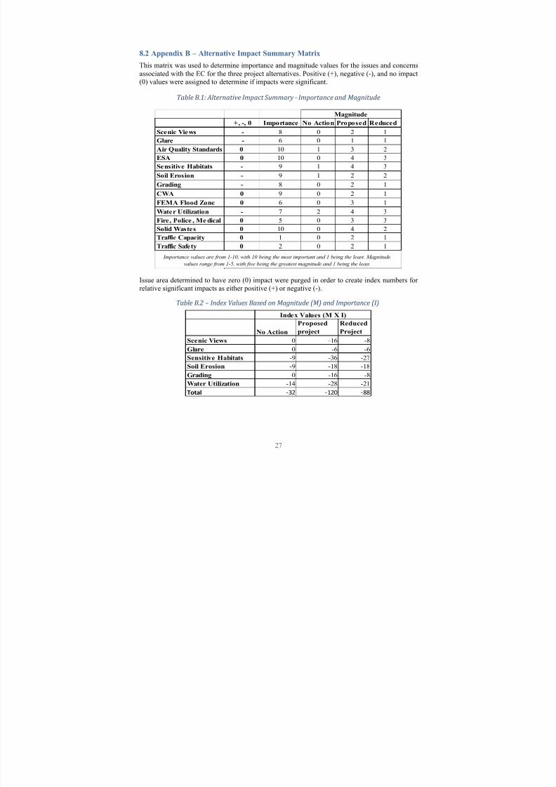
8.2 Appendix B ± Alternative Impact Summary Matrix
This matrix was used to determine importance and magnitude values for the issues and concerns
associated with the EC for the three project alternatives. Positive (+), negative (-), and no impact(0) values were assigned to determine if impacts were significant.
Table B.1: Alternative Impact Summary - Importance and Magnitude
+, -, 0 Importance No Action Proposed Reduced
Scenic Views - 8 0 2 1
Glare - 6 0 1 1
Air Quality Standards 0 10 1 3 2
ESA 0 10 0 4 3
Sensitive Habitats - 9 1 4 3
Soil Erosion - 9 1 2 2
Grading - 8 0 2 1
CWA 0 9 0 2 1
FEMA Flood Zone 0 6 0 3 1
Water Utilization - 7 2 4 3
Fire, Police , Me dical 0 5 0 3 3
Solid Wastes 0 10 0 4 2
Traffic Capacity 0 1 0 2 1
Traffic Safety 0 2 0 2 1
Magnitude
Importance values are from 1-10, with 10 being the most important and 1 being the least. Magnitude
values range from 1-5, with five being the greatest magnitude and 1 being the least
Issue area determined to have zero (0) impact were purged in order to create index numbers for relative significant impacts as either positive (+) or negative (-).
Table B.2 Index Values Based on Magnitude (M) and Importance (I)
Eric Hughes1540 12th St. � LosOsos,CA 93402 � (925) 683-7679 � edhughes@calpoly .edu
Objective Obtain a job in a f ield that aims to resolv e today·s environmental challenges
EducationCalif ornia Poly technic State Univ ersity, San LuisObispo Bachelor of Science in Environmental Management and Protection, expected Spring 2011Minor: W ater ScienceGPA: 3.69 Dean·s Honor List
Relevant Coursework and SkillsLand & Resource Measurements Microsoft W ord & Excel GISHabitat Management Environmental Impact Analysis Conf lict Management
Related ExperienceMill Creek Restoration Project,Cal Poly Sw anton Pacif ic R anch W inter 2008
Volunteer Work Cal PolyOrganic Farm, San LuisObispo, CA Spring 2009 - present
y W orked w ith an 11-acre CCOF certif ied org anic f arm
y Har v ested and pack aged crops
Clubs and Activities Association of Environmental Professionals (AEP),Cal Poly Chapter Fall 2009 Ag Council Representativ e
y Elected to represent AEP at College of Agriculture, Food and Environmental Sciences student council
y Ser v e onAEP Executiv e Board; plan club e v ents, assist w ith leadership decision-mak ing , etc.
y Improv ed AEP involv ement in extra curricular activities
Leadership and Honorsy Treasurer, Las Positas College Environmental Club (2008)y Alpha Gamma Sig ma Honors Society ( Lifetime member), Las Positas College (2008)
Work History
Danville Music, Danville, CA Nov . 2006- Sept. 2008RetailAssistant
y Responsible f or opening , closing , sales, customer ser vice, repairs, cash handling , janitorial ser vices, ordering supplies, and rentals
y Enhanced store eff iciency and customer relations
y Assisted customersw ith purchase, rental, and repair decisions Holistic Solutions, Oak land, CA Apr. 2003-Aug. 2006
OperationsManager
y Super vised staff of ten, including hiring , training , scheduling , pay roll, and perf ormance e valuation
y Mediated patient concerns and improv ed patient relationships
738 Grand Ave, #11 CA 93405 � (530)518-3786 � lross [email protected]
Objective: Obtain a job in a field that aims to resolve today·s environmental challenges
Education:California Poly technic State University, San Luis ObispoBachelor of Science in Environmental Management and Protection , Spring 2010Minor: Agricultural Business GPA: 3.00
Relevant Coursework and Skills: Land & Resource Measurements Microsof t Word & Excel GISHabitat Management Environmental Impact Analy sis Conflict Management
Related Experience:Morro Group, SWCA Internship Winter 2008
y Green House GasMitigation Calculation Spreadsheet Development
y Environmental Document Preparation
Clubs and Activities:
Association of Environmental Professionals (AEP), Cal Poly Chapter
y President: 2008-2009
y Elected to represent AEP at College of Agriculture, Food and Environmental Sciences student council
y Serve on AEP Executive Board; plan club events, assist with leadership decision -making, etc.
y Improved AEP involvement in extra curricular activities
John Karamanlis1469 Lizzie Street � San Luis Obispo � CA 93401 � (408) 209-1599 � [email protected]
Objective Gain employment in the f ield of Env ironmental management, consulting and protection
EducationCalifornia Poly technic State Uni versity , San Luis Obispo, CABachelor of Science in Environmental Management and Protection , Expected fall 2010Concentrations� Biofuels
Educated at local state school in Sw itzerland (K throug h Grade 7) 1992-2001
Relevant Coursework Bioconversion & Biodiesel production Organic Chemistry Forest Survey ing Internal Combustion Eng ines Field Botany & Dendrology GISEnv ironmental & Business Law Env ironmental Impact Analysis Mini Tab Sof t wareEnv ironmental & Business Economics Soil Science and Geology Microsof t
�
ord & Excel
�
ork History California Polytechnic State University, San Luis Obispo, CA Summer 2008 - Present Bio Resource and Agricultural Eng ineering technician
y Construction, management and maintenance of Bioref inery on campus
y Algae culti vation, harvesting and processing for alternati ve�
renewable energy production
y Student Research and Development o Lab-scale and Industrial -scale algae culti vation for sustainable Bioenergy o CO2 Seq uestration from ethanol -fermentation throug h closed-system Algae culti vation
Calabazas Cyclery, San Jose, CA 2002-2006
y Sold and serv iced hig h end Mountain, road & bmx bikes
y Taug ht bike maintenance clinics
Clubs and Activities Association of Environmental Professionals (AEP) , Cal Poly Chapter Fall 2009 - Present Member
Algae Biofuels Club (ABC), Cal Poly Chapter Fall 2009 - Present Co-Founder & member
Related ExperienceEnergy for a Sustainable Society , Cal Poly campus, San Luis Obispo, CA
�
inter 2010Guest Lecturer
Engineering Potential In College (EPIC) , Cal Poly campus, San Luis Obispo, CA Summer 2009Instructor for lab and lecture
AEP State Research competition , San Francisco, CA Spring 2009Student Research Project ² 2nd Place
Focus the Nation, Cal Poly campus, San Luis Obispo, CA�
inter 2009Student Project Showcase
Skills/KnowledgeForeign Languages German ² f luent Sw iss-German ² f luent Greek ²
enderson A v e. � San Luis Obispo, C A 93405 � ( 805 ) 550-5440 � sry oung �
calpoly.edu
Ob�
ecti v e Obtain a job in a field that aims to resol v e today �
s env ironmental challeng es
EducationCalif ornia
oly technic State Uni v ersity , San Luis Obispo, C ABachelor of Science in En v iron enta
anage ent and Protection, e pected Spring 2011 Concentrations
ield and W ildlif e Biolog y ,
y drolog y and W atershed
anag ementG
A 3
ª
09 Dean�
s
onor List
Uni v ersity of
elbourne,
elbourne, VIC, Australia Natura
Resources
anage entDe part ent Exchange, W inter 2008 ² W inter 2009
Re
e v ant Coursewor«
and S«
illsLand &
¬
esource
easurements
icrosof t W ord & cel GIS W atershed
anag ement nv ironmental Impact Analysis Conflict
anag ement
ini Tab Statistical Sof t w are
ield Botany Indi v idual and
opulation colog y
ammalog y Ornitholog y Community and cosystem colog y
¬
esource La w nf orcement nv ironmental La w W etlands
anag ement¬
esource conomics and V aluation perimental Design Soil Science and Geolog y
Related Experience Sierra National ForestOH V Project ® Sierra National
orest, Bass Lak e District Summer 2010 Sur v ey ed OH V routes to be designated f or official public use, and collected data f or associatedNEP A document
V olunteer Wor«
Conser v ation V olunteers
̄
ustralia® Nuhlunbu y® N T® ̄
ustralia Summer 2009
y W ork ed with CSI°
O and indig enous land manag ement on invasi v e species monitoring prog ram
y Baited identified problem areas and took GPS data on Anoplolepi ±
g ²
a ³
i l i pes sig hting s y Participated in li v e capture of an estuarine crocodile with Y olng u
́
ang ers Clubs and
µ
cti v itiesµ
ssociation of En v iron¶ ental Prof essionals (µ
EP), Cal Poly Chapter ·
all 2009 ̧
ember
y Attended meeting s and AEP acti v ities
Wor¹
History Calif ornia Pol ytechnic State Uni v ersit yº San Luis Obispo, C A January 2010 - PresentGIS Technician
y Preparation of GIS map lay outs
y Assisting students with GIS projects
United States Forest Ser v ice» North ¼
ork , C A June 2009-September, 2009 Botany Technician
y Collection of field data on endang ered and sensiti v e plant species occurring in the Sierra National ½
orest
y Identification and removal of no¾ ious w eeds
y Post use rang eland sur v eys of g razed meado ws
y Monitoring of sites pre v iously treated f or no¿ ious w eeds, OH V roads to be opened as an official routeand burn areas
Sean ran1822 Broad St � San LuisObispo,CA 93401 � (714) 728-7221 � sktran@calpoly .edu
Objective AcÀ uire a professional position inwhich environmental management and protection are of c
EducationCalif ornia Poly technic State Univ ersity, San LuisObispo Bachelor of Science in Environmental Management and Protection, expected Spring 2010Minor: Ecolog y GPA:
Á
.89 Dean·s Honor List
Relevant Coursework and SkillsLand & Resource Measurements Plant and animal ecolog y GISHabitat Management Environmental Impact Analysis Biolog y
Related ExperienceCommunication andOutreach Intern, INFORM Inc² New
Â
ork ,New Â
ork Summer 2008
Volunteer Work Cal PolyOrganic Farm, San LuisObispo, CA Spring 2009 - present
y W orked w ith an 11-acre CCOF certif ied org anic f arm
y Har v ested and pack aged crops
Clubs and Activities Association of Environmental Professionals (AEP),Cal Poly Chapter Fall 2007 Attended meeting s and volunteer activities
Leadership and Honors
y Public education on environmental a w areness campaig n (2008)
Work HistoryI
Ã
FORM Inc, New Ä
ork ,NÄ
Å
une 2008-Sept 2008Communication and Outreach Intern y Researched and prepared se v eral environmental consultation documents on sustainable building materials
y Helped production team produce, disseminate, and track progress of paper recycling videoy Org anized, produced and executed public education campaig n on climate change and consumer
responsibility
Æ
outhÇ
ransitions Program, San LuisObispo,CAÈ
an 2009 ² È
une 2010 Tutor/Mentor
y Super vised se v eral f oster children at a time
y Tutored in various high school subjects y As a mentor, act as a medium through which children can express frustrations and seek ad vice