AD-A268 055 GROUND WAVE EMERGENCY NETWORK FINAL OPERATIONAL CAPABILITY ENVIRONMENTAL ASSESSMENT FOR CENTRAL TENNESSEE RELAY NODE SITE NO. RN 8E91 1TN DTIC Fer ElECTE y1993 5 WUG17 1993L E E p 93-18576 Electronic Systems Centb, Air Force Material Command, USAF Hanscom AFB, Massachusetts 01731-1623
Transcript
AD-A268 055
GROUND WAVE EMERGENCY NETWORK
FINAL OPERATIONAL CAPABILITY
ENVIRONMENTAL ASSESSMENT
FOR
CENTRAL TENNESSEE RELAY NODE
SITE NO. RN 8E91 1TN
DTICFer ElECTE
y1993 5 WUG17 1993L
E E
p 93-18576
Electronic Systems Centb,
Air Force Material Command, USAF
Hanscom AFB, Massachusetts 01731-1623
REPORT DOCUMENTATION PA -'PS om EoO ,
4. TiTLE AND SUBTITLE 5. FUNDING NUMBERS
6. AUTHOR(S)
7. PERFORMING ORGANIZATION NAME(S) AND ADDRESS(ES) S. PERFORMING ORGANIZATION
671L&r- --LOA/"C -CILS7A- 6IVl5 (le,-~~V REPORT NUMBER
9. SPONSORING /MONITORING AGENCY NAME(S) AND ADDRESS(ES) 10. SPONSORING, 1`001IHCJXINCIAGENCY REPORT NUMBER
11. SUPPLEMENTARY NOTES
l2a. DISTRIBUTION/AVAILABILITY STATEMENT 12b. L),.TRi;jT;%iiU CC, i p i
13. ABSTRACT (Max:mum 200 words)
e4A~ 2e,~'v dA.. eiS
14.SUBJECT TERMS 15. NUM~ilER OF PPGES
16. PRICE CODE
I SEURIY CASSFICTIO 18 SECURITY CLASSIFICATION 19. SECURITY CLASS :ATION 20 LIMITATIONOF ASs rzAU,OF REPORT OF THIS PAGE OF ABSTRACT
1SI I
-28oJ-5500
GROUND WAVE EMERGENCY NETWORK
FINAL OPERATIONAL CAPABILITY
ENVIRONMENTAL ASSESSMENT
FOR
CENTRAL TENNESSEE RELAY NODE
SITE NO. RN 8E911TN
Accesion For
NTIS CRA&VDTIC TABUtiannounced ]Justification
By ...................
19 February 1993 Dizl& ~uutioniAvailability Codes
Avail and I orDist Special
L4/ I
Electronic Systems Center
Air Force Material Command, USAF
Hanscom AFB, Massachusetts 01731-1623
FINDING OF NO SIGNIFICANT IMPACT
NAME OF ACTION: GROUND WAVE EMERGENCY NETWORKCENTRAL TENNESSEE RELAY NODE
DESCRIPTION OF PROPOSED ACTION ALTERNATIVES:
The U.S. Air Force plans to construct a radio communications relay node in central Tennessee (Coffee or Franklincounty) as part of the Ground Wave Emergency Network (GWEN) communications system. Three actionalternatives associated with three candidate GWEN sites (CGSs) in central Tennessee and the no actionaltemative have been considered and evaluated in an environmental assessment (EA).
GWEN is a radio communications system designed to relay emergency messages between strategic military areasin the continental United States. The system is immune to the effects of high-altitude electromagnetic pulse(HEMP) energy surges caused by nuclear detonations in the ionosphere that would disrupt conventionalcommunications equipment. A failure of such equipment would prevent timely communications among topmilitary and civilian leaders and strategic Air Force locations and prevent U.S. assessment and retaliation during anattack. GWEN is an essential part of a defense modernization program to upgrade and improve our nation'scommunicntions system, thereby strengthening deterrence.
The GWEN system is a network of relay nodes, receive-only stations, and input/output stations. The relay node incentral Tennessee would be part of the Final Operational Capability (FOC) phase of the GWEN system and wouldestablish essential links with adjacent nodes in the network.
In September 1987, the U.S. Air Force Electronic Systems Division, Hanscom Air Force Base, Massachusettspublished a Final Environmental Impact Statement (FEIS) for the GWEN FOC that addressed the system as awhole and identified expected environmental effects common to all sites. Section 5 of the FEIS described a sitingprocess that is designed to minimize the potential for environmental impacts. This process has three distinctphases: network definition, regional screening, and individual site evaluation. Network definition identified theneed for a relay node in central Tennessee. Regional screening resulted in the identification of three CGSs incentral Tennessee that met the exclusionary and evaluative criteria described in that FEIS. Individual siteevaluation examined the relative suitability of the CGSs through site-specific technical studies. The EA is a part ofthe third phase and is tiered from that FEIS. It addresses the potential environmental effects of the three actionalternatives and the no action alternative.
The proposed relay node in central Tennessee will be an unmanned facility located on approximately 11 acres ofland and, once constructed, will resemble an AM radio broadcast station. The facility will consist of a 299-foot-tall,low-frequency (LF) transmitter tower, three equipment shelters, an access road, and associated fences. Thetower will be supported by 24 guy wires, including 12 top-loading elements. An equipment shelter at the towerbase will contain an antenna tuning unit. An 8-foot-high chain link fence topped with barbed wire will surround thetower base and associated equipment shelter. A radial ground plane, composed of 100, 0.128-inch-diametercopper wires buried about 12 inches underground, will extend out about 330 feet from the tower base. A 4-foot-high fence will be installed around the perimeter of the copper radials.
A secon.d equipment area located at the site perimeter will contain two shelters housing a back-up power group(BUPG) with two internal fuel storage tanks and radio processing equipment. The BUPG will operate during poweroutages and for testing purposes. An LF receive antenna, consisting of a pair of 4-foot-diameter rings mountedon a 10-foot pole, and an ultrahigh-frequency (UHF) antenna, used for communicating with airboine input/outputterminals and consisting of a 9-foot-high whip-like antenna mounted on a 30-foot-high pole, will also be located inthis area. An 8-foot-high chain link fence topped with barbed wire will enclose the entire equipment area. A 10-foot-wide gravel road will conncct tNis arc•a to the tower tase. A 12-"1,kot-wide gravel road will provide access to thesite from a public road.
The station will use existing commercial three-phase electric power and telephone service. Power and telephoneservice will be brought to the site through either overhead or buried lines, depending on local utility practices. Inits ready status, the antenna will transmit in the LF radio band at 150 to 175 kilohertz for a total of 6 to 8 secondsper hour.
One of the three action alternatives is discussed in this Finding of No Significant Impact (FONSI). Because ofsignificant visual impacts and unknown impacts on historic properties, the Camp Forrest site (CGS-2) will not beconsidered in this FONSI. Because impacts to surface water and historic properties are unknown, the UTSI Roadsite (CGS-4) will not be considered.
ANTICIPATED ENVIRONMENTAL EFFECTS
The EA evaluated potential impacts to the physical, biological, and socio-cultural environment from constructionand operation of a relay node.
The project would have no significant impacts on physical resources. Erosion and increased runoff would beminimized by using proper erosion control techniques during construction and by replanting the site afterwards.Impacts on mineral resources would be minor. Paleontological resources are not likely to occur on the site;therefore significant impacts to them are not anticipated. No prime farmland would be removed from production.Water quality would not be significantly affected because increases in copper concentrations due to corrosion ofthe ground plane would be negligible. Air quality would not be significantly affected. During construction,temporary and insignificant increases in emissions would occur, and during operation, emissions from the BUPGwould not be sufficient to result in violation of air quality standards.
The project would have no significant impacts on biological resources. The site is located on an agricultural fieldand does not contain sensitive wildlife habitat. The site does not contain wetlands and is not within a 100-yearfloodplain. Informal consultation with the U.S. Fish and Wildlife Service indicated that the project would notadversely affect any threatened or endangered species. No state-listed rare, threatened, or endangered speciesor unique biological communities are listed by the Tennessee Department of Conservation as occurring on thesite. Bird-tower collisions may occur but would not be significant because the tower would be located away fromprimary bird habitats and migration routes.
The project would have no significant impacts on socio-cultural resources. Construction would have a small,beneficial impact on the local economy, in part by providing temporary employment for contractors andconstruction workers. Community support systems would not be significantly affected. Land use and noiseimpacts would not be significant. The relay node signal would not interfere with commercial television or radiobroadcasts, amateur radio operations, garage door openers, or pacemakers. Radio-frequency emissions outsidethe fenced area around the tower base would not pose a health hazard to humans or animals. The TennesseeHistorical Commission was consulted and concurs that the project would not affect significant cultural resources.Significant impacts to Native American traditional, religious or sacred sites are not anticipated. A visual analysisconducted in accordance with the criteria developed in the FOC FEIS concluded that the relay node facility wouldnot cause significant visual impacts.
CONCLUSIONS:
No significant impacts to the surrounding environment would be caused by construction and operation of theproposed relay node on the Fire Tower site (CGS-3). Therefore, an environmental impact statement for a GWENrelnode at the cited location in central Tennessee is not required.
David 0. Williams, Colonel, USAF DateChairmanHO ESC Environmental Protection Committee
2
PREFERRED GWEN SITE REPORTCENTRAL TENNESSEE
The U.S. Air Force is proposing to construct a relay node for the Ground WaveEmergency Network (GWEN) in Central Tennessee. The Air Force has followed thesiting process described in Section 5 of the Final Environmental Impact Statement(FEIS) for the Final Operational Capability (FOC) phase of the GWEN program toidentify alternative Candidate GWEN sites (CGSs). The three CGSs identified inCentral Tennessee are referred to as the Camp Forrest, Fire Tower, UTSI sites.
This report summarizes the process of selecting the preferred site from among thethree CGSs. This Preferred GWEN Site Report (PGSR), along with a site-specificEnvironmental Assessment (EA) and Finding of No Significant Impact (FONSI), isbeing distributed for information and comment in compliance with the Air Force'sprocess of Interagency and Intergovernmental Coordination for EnvironmentalPlanning (IICEP).
Operational, environmental, and developmental suitability; construction and realestate acquisition costs; and public comments and concerns are all factors whichhave been considered in arriving at the selection of the preferred site.
Without an operationally suitable location, connectivity of the relay node in CentralTennessee to the GWEN network cannot be achieved. Ground conductivitymeasurements are acceptable at all three sites. During site-specific studies, no radiofrequency interference was detected in GWEN frequency bands which wouldinterfere with the operation of the GWEN receiver. Also, operations at any of thesites would pose no interference with other known systems. UHF line-of-sitecoverage for a potential airborne interface would be largely uninhibited at either ofthe three sites. Therefore, all three sites are operationally suitable.
The next major factor considered in selecting the preferred site is environmentalsuitability. The environmental suitability of each CGS was determined frominformation provided by an independent field analysis and is documented in the EA.The EA for the three CGSs was completed in February 1993. Based on theenvironmental analysis of each CGS, the Air Force has concluded that no significantenvironmental impacts would occur at the Fire Tower or UTSI sites. A FONSI forthese two sites was completed on 4 March 1993. Significant visual impacts to thetown of Tullahoma could occur if the site were constructed on the Camp Forrest site.Therefore, only the Fire Tower and UTSI sites are environmentally suitable.
All three CGSs are suitable for development as a GWEN relay node. The FAA hasapproved construction of the GWEN relay node at either of the three CGSs.Construction costs varies dramaticly between the three sites due to the distance to3-phase power and telephone, and the length of access road required at eachindividual site. Although, construction costs are lowest at the UTSI and Fire Towersites, all sites are developmentally acceptable.
The final consideration for selection of the preferred GWEN site is the real estateacquisition. Since all three CGSs are located on an Air Force installation, no lease orpermits are necessary.
With operational factors acceptable, environmental factors weighed, anddevelopmental factors and acquisition costs considered, the Air Force prefers the FireTower site. The Fire Tower site is preferred because it ranks best overall among the
previously mentioned criteria including lowest overall construction and acquisitioncosts for otherwise qualified sites.
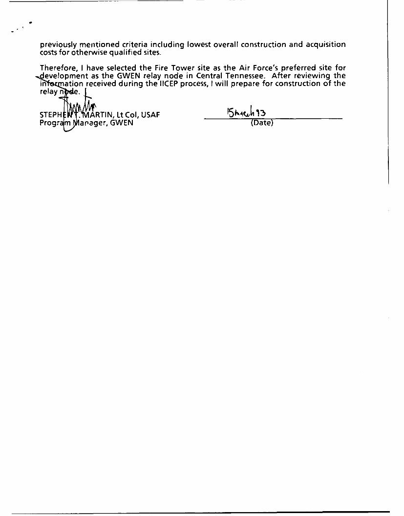
Therefore, I have selected the Fire Tower site as the Air Force's preferred site fordevelopment as the GWEN relay node in Central Tennessee. After reviewing thein- a ation received during the IICEP process, I will prepare for construction of therelay n•
STEPH I ARTIN, Lt Col, USAF 15,3Progr m arager, GWEN (Date)
TABLE OF CONTENTS
Section Title Page
S U M M A RY ..................................................... v
1.0 PURPOSE AND NEED FOR ACTION ............................. 1-1
2.0 ALTERNATIVES INCLUD!NG THE PROPOSED ACTION .......... 2-1
2.1 Common Features of the Action Alternatives ..................... 2-1
2.1.1 Site Selection Process ........................................ 2-1
2.1.2 Relay Node Construction and Operation ......................... 2-4
2.2 Alternative 1: Camp Forrest Site (CGS-2) ....................... 2-9
2.3 Alternative 2: Fire Tower Site (CGS-3) .......................... 2-9
2.4 Alternative 3: UTSI Road Site (CGS-4) ......................... 2-10
2.5 No Action Alternative ......................................... 2-10
The GWEN system consists of a network of relay nodes, receive-only stations, and
input/output stations. Each relay node, such as the one proposed in cEntral Tennessee,
consists of a guyed radio tower facility similar to those used by commercial AM broadcast
transmitters.
A Final Environmental Impact Statement (FEIS) for the GWEN Final Operational
Capability (FOC) was published in September 1987 by the Electronic Systems Division,
Hanscom Air Force Base, Massachusetts. That FEIS addressed the GWEN system as a
whole, identifying expected environmental effects common to all sites. Section 5,
beginning on page 5-1 of the FEIS, describes a siting process that is designed to
minimize the potential for environmental impacts. This process has three distinct
phases: network definition, regional screening, and individual site evaluation.
Phase 1, network definition, identified the geographic coordinates that met the
operational needs and technical constraints of the network. Each set of coordinates
became the center of a circular site search area (SSA) with a 9-mile radius (250 square
miles). The SSA discussed in this Environmental Assessment (EA) was defined by the
boundaries of the Arnold Air Force Base (AFB) in central Tennessee, at latitude .' 5.38° N
and longitude 86.091W. All areas within the boundaries of Arnold AFB were considered,
with the exception of the Arnold Engineering Development Center (AEDC), an
v
aerospace technology research center. The principal communities around Arnold AFB
are Tullahoma, Manchester, and Winchester.
Phase 2, regional screening, involved the application of exclusionary and evaluative
criteria to the SSA to avoid environmentally sensitive areas. The remaining areas,
called potential areawide sites (PAWS), became the focus of the siting process. A field
investigation for centr-j! Tennessee was conducted in November and December 1989.
Eight sites were i-entified as potential candidate GWEN sites (PCGSs) by applying the
site selection criteria of the FEIS including criteria for wildlife refuges, high voltage power
lines, 100-year floodplain, railroad tracks, tall metal structures, residential standoffs,
recreational standoffs, proximity to three-phase power distribution, and paved roads.
Because the SSA is located on U.S. Air Force land, rights-of-entry were not necessary
to conduct field investigations. The initial field investigations in November 1989
eliminated four of the eight potential sites due to conflicts with site selection criteria.
Further site investigations in December 1989 eliminated one additional site, leaving
three candidate GWEN sites (CGSs) for further review. These CGSs were described in
the Preliminary Site Evaluation Report (PSER) of December 21, 1989, and ..re
presented in this EA.
Phase 3, individual site evaluation, involves evaluating the relative suitability of the
candidate sites through site-specific technical studies. This EA is a product of those
evaluations and di-- Aes the three siting aternatives in central Tennessee. It
addresses only those criteria that apply to the candidate sites. The fourth alternative, no
action, would impair performance of the GWEN system but leave the environment
unchanged.
To be suitable for construction and operation, a site should measure at least 700 feet by
700 feet (approximately 11 acres), be relatively level and undeveloped, be free of natural
or man-made obstructions, and have soils capable of supporting the relay node
structures. The site should be close to all-weather roads, commercial three-phase
power, and telephone lines to minimize costs. To operate effectively, the site must be
located at least a minimum distance from obstructions that could affect reception and
transmission. These include buildings, towers, high-voltage power lines, and other
vi
communications systems or sources of radio-frequency interferenue. Specific minimum
distances depend on height and power levels of identified obstructions or interfering
sources.
This EA shows that construction and operation of a GWEN relay node on the Camp
Forrest site (CGS-2) would have significant visual impacts, as discussed in Section 4.2
of this EA.
The Camp Forrest site (CGS-2) and the University of Tennessee Space Institute (UTSI)
Road site (CGS-4) conflict with Federal Aviation Administration (FAA) flight safety
requirements which preclude construction of a tower on these sites. They therefore were
not considered for an historic structures survey nor were they cleared for water quality
impacts by the Tennessee Division of Water Management. Impacts on historic properties
at both sites and water quality impacts at the UTSI Road site, which is within 300 feet of
surface water, are therefore unknown.
The project would have no significant impacts if constructed on the Fire Tower site (CGS-
3). During the 6-week construction period, the project would cause temporary and
insignificant air quality and noise impacts and slight increases in traffic. It would have a
small, beneficial impact on the local economy, in part because it would provide
temporary employment for contractors and construction workers. If constructed on this
site, the project would have no significant impacts on air quality; water quality; land use;
mineral resources; known paleontological resources; biological resources, including
threatened and endangered species; or cultural resources that are listed, eligible, or
potentially eligible for listing on the National Register of Historic Places. In addition,
visual impacts would not be significant. Radio-frequency emissions outside the fenced
area around the tower base would not pose a health hazard to humans or animals.
vii
1.0 PURPOSE AND NEED FOR ACTION
The proposed action covered by this Environmental Assessment (EA) includes
construrtion and operation of a relay node of the Ground Wave Emergency Network
(GWEN) in central Tennessee (see Figure 1.1 of this EA). This relay node will provide
essential connections with adjacent nodes in the network. The major features of a
GWEN relay node and associated environmental impacts common to all sites are
addressed in the Final Environmental Impact Statement (FEIS) for the Final Operational
Capability (FOC) phase of GWEN, which was published in September 1987 by the
Electronic Systems Division, Hanscom Air Force Base, Massachusetts. This EA is tiered
from that FEIS and addresses site-specific conditions at the candidate GWEN sites
(CGSs) for this particular site search area (SSA).
The purpose of GWEN is to provide to the President and the National Command
Authority a strategic communications network that is immune to the effects of high-
altitude electromagnetic pulse (HEMP) and will carry critical attack warning and force
execution data. As a result, GWEN will remove any possibility of potential aggressors
taking advantage of the electromagnetic pulse generated by a high-altitude nuclear
burst. A HEMP surge would disrupt the nation's electric power line transmission
capability, cripple electronic devices, and adversely affect skywave communications
networks based on conventional electronics. GWEN provides a low-frequency (LF)
ground wave communication network that will not be affected by HEMP effects. It
thereby strengthens deterrence by removing the option of beginning an attack against
the United States by using HEMP effects.
A partial GWEN network, called the Thin Line Connectivity Capability (TLCC), has been
completed. It contains 8 input/output stations, 30 receive-only stations, and 54 relay
nodes. The TLCC provides a limited level of HEMP-protected communications to
strategic forces and the National Command Authority.
The FOC phase of GWEN will add 29 relay nodes. The FOC will allow communication
along several routes, thereby enhancing system availability and ensuring that vital
communications will be maintained.
1-1
SLocation of Coffee and Franklin Counties q-ag aw Ilk•• ,•',, ,.. ,: 9•
• 'l'i' "•' '" " • • , ;• . -
7'- . • ... ... t/
Sv;ntoTowt
D.e A,., ••
BAS MP OUCE:U..GS. 197 REISD 172 &196 (EVSE 178
SCLE1:5000--HATAOOA.TEN. NC. CLUBI A TENk A
QUADRANGVEAEDC(Arnld nginerig DeelopentCentr)
Tu= Bounar ofAnldArFrcaaei
0.-2
2.0 ALTERNATIVES INCLUDING THE PROPOSED ACTION
The three action alternatives are site-specific applications of the standard relay node
design presented in the FEIS. Consequently, they share a number of features that are
discussed in Section 2.1 of this EA. The site-specific features are discussed in Sections2.2 through 2.4 of this EA. Site descriptive data was obtained during field investigations
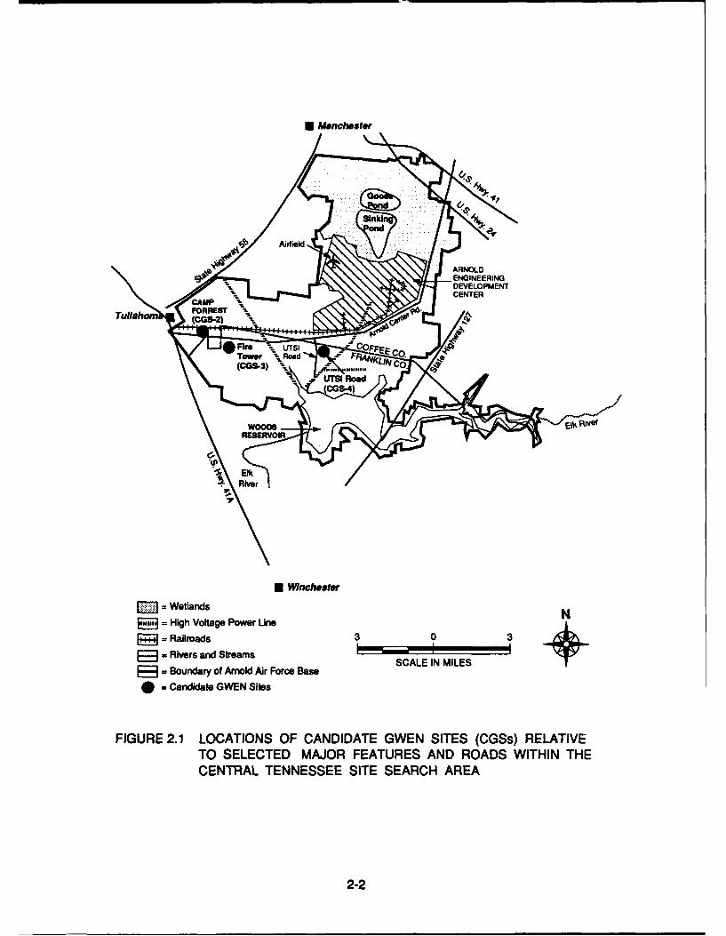
conducted in November and December of 1989. Figure 2.1 of this EA shows the three
CGSs in relation to the major features of the SSA. Figure 2.2 and Appendix B of this EAshow the locations of the CGSs in relation to roads and surrounding topography,
respectively.
2.1 Common Features of the Action Alternatives
2.1.1 Site Selection Process
The process used to select sites is described in Section 5, beginning on page 5-1 of the
FEIS. This process has three distinct phases: network definition, regional screening, and
individual site evaluation. Appendix A of this EA provides a diagram of the site selection
process. The environmental criteria used in this process are defined in Tables 5-1 and
5-2, pages 5-7 through 5-14 of the FEIS.
Phase 1, network definition, involved locating network nodes to optimize their
performance while serving a predetermined number of users. A typical GWEN ground
wave has an effective range of about 150 to 200 miles. Thus, relay nodes could not be
located independently; changing the location of one would affect the connectivity with
other nodes in the network. The SSA was defined by the boundaries of Arnold Air Force
Base (AFB).
Phase 2, regional screening, involved the application of exclusionary and evaluative
criteria to the SSA to identify areas that might contain operationally acceptable sites
outside environmentally sensitive areas. The resulting search areas, called potential
2-1
* Winchester
lAi rfield Base
CENTER
S= Candsda GE CO.
Elkd
S=High Voltage Power Line '
JP = Railroads 3 0 3
p~ : Rivers and Strams SCL I N IE
S= Boundary of Arnold Air Foroe Base
. Candidlate GWEN Sites
FIGURE 2.1 LOCATIONS OF CANDIDATE GWEN SITES (CGSs) RELATIVETO SELECTED MAJOR FEATURES AND ROADS WITHIN THECENTRAL TENNESSEE SITE SEARCH AREA
2-2
* = G~sBASEMAPSOURE: .E..C. ream~. RI nteratinal
CGS2. am Foes - ounar ofAroldAirFocv m4
AIR FORC BAEINCOEEADFRNLIEOUTE
000Y POWABL PUMIN TYI OBNT E1LF~LYLC1TRAM~i~2-3
areawide sites (PAWS), were submitted to appropriate federal, state, and local officials
for review. The PAWS were then redefined, as appropriate, by incorporation of the
comments of the reviewers, and a field investigation was conducted to find suitable
candidate sites for a GWEN relay node within the redefined PAWS.
The field investigation for central Tennessee was conducted in November and
December 1989. Eight sites were identified during automobile-based surveys as
potential candidate GWEN sites (PCGSs). Because the SSA is located on Air Force
land, rights-of-entry were not necessary to conduct field investigations. Arnold AFB
officials eliminated four of the eight sites as being unsuitable. Following evaluation
against the environmental criteria set forth in the FEIS, three of the remaining four
PCGSs were recommended as CGSs for further review.
Phase 3, individual site evaluation, of which this EA is a part, is then used to determine
the relative suitability of the candidate sites through site-specific technical studies. This
EA presents the results of the environmental portions of those studies and covers site-
specific impacts associated with construction of a relay node in central Tennessee.
These are summarized in Sections 4.2 through 4.4 of this EA. The findings of this EA
and site-specific studies of operational parameters will be used to select a preferred
GWEN site (PGS).
2.1.2 Relay Node Construction and Operation
A typical relay node site is located on approximately 11 acres of land (see Figure 2.3 of
this EA). It is an unmanned facility consisting of a 299-foot-tall, three-sided, 2-foot-wide
LF transmitter tower, three equipment shelters, an access road, and associated fences.
The tower has a base insulator and lightning protection and is supported by 24 guy
wires, including 12 top-loading elements to further strengthen the signal and provide
additional structural support.
These guy wires and top-loading elements are attached to the tower and to 18 buried
concrete anchors. The sizes of these anchors and their depth of burial varies with local
soil and bedrock properties. However, the guy-wire anchors typically are rectangular
2-4
EquimentsAten
Guy iresSiAeAra
FIGURE~~~~~~~~70' 2.7Y0A0LYU'FFO EA OD TTO
2-5ihFec
blocks buried 5 feet below the surface. If bedrock occurs at or near the surface, the
anchors are special rock-embedded rods. The tower base is concrete with a cross-
section area resembling an inverted T. The size of this foundation is determined by soil
conditions.
A radial ground plane, composed of 100 buried copper wires, extends out from the base
of the tower. Each wire is 0.128 inch in diameter, about 330 feet long, and buried
approximately 12 inches underground. The ground plane helps to strengthen the
broadcast signal, and the number and length of the wires depend on the soil conductivity
at the site. A 4-foot-high fence is installed around the perimeter of the ground plane to
protect the ground plane and guy anchors and to prevent inadvertent exposure to
electric shock resulting from the buildup of static electric charge.
In addition to the main tower, the relay node has two other antennas. One is an LF
receive antenna made up of a pair of 4-foot-diameter rings mounted on a 10-foot pole.
The second is an ultrahigh-frequency (UHF) antenna used for communicating with
airborne input/output terminals. It is a 9-foot-high whip-like antenna mounted on a 30-
foot-high pole. Both antennas are located within the equipment area at the perimeter of
the site, which is enclosed by an 8-foot-high fence.
The siting and design of the tower are coordinated with the Federal Aviation
Administration (FAA) to ensure compliance with FAA standards and regulations. The
tower is equipped with a white strobe light at the top, which emits 40 flashes per minute
and is rated at 20,000 candelas for daytime and twilight use and 2,000 candelas for
nighttime use. To minimize glare at ground level, the light is focused upward and
horizontally outward.
GWEN operates intermittently in the LF radio band at 150 to 175 kilohertz (kHz). For
comparison, the low end of the AM band for commercial broadcasts is 530 kHz. The
peak broadcast power for each GWEN tower is from 2,000 to 3,000 watts, depending on
local soil conditions. In its ready status, GWEN typically transmits for a total of 6 to 8
seconds per hour. GWEN does not interfere with commercial television, radio
2-6
broadcasts, amateur radio operations, garage door openers, or pacemakers, as noted in
Section 2.1.1.1, page 2-3 of the FEIS.
All equipment shelters are anchored to concrete pads. One shelter, located at the base
of the tower, houses the antenna tuning unit (ATU). Two other shelters are located side
by side in the equipment area enclosed at the perimeter of the property. One houses
radio-processing equipment, and the other houses a 70-horsepower, back-up diesel
generator and two aboveground fuel tanks. The generator operates 2 hours per week
for testing purposes and during power outages. Locked, 8-foot-high chain link fences
topped with barbed wire secure the equipment shelter areas at the base of the tower and
at the perimeter of the site to provide safety and to inhibit unauthorized entry. A 12-foot-
wide gravel road provides access to the equipment area enclosure at the perimeter of
the property. A 10-foot-wide gravel road leads from the equipment enclosure to the
tower.
Fuel is stored in two aboveground steel tanks inside the generator shelter. Tank
capacities are 559 gallons and 461 gallons. Each tank pipes fuel separately to the back-
up power group (BUPG) and is equipped with two outlet shut-off valves, one controlled
manually and one controlled automatically. If a leak occurs, fuel will flow into a floor
drain leading to a tightly capped pipe extending outside the BUPG. Once approximately
2 gallons of fuel accumulate in the pipe, a "liquid spill" signal is sent to the GWEN
Maintenance Notification Center, which will dispatch maintenance personnel. However,
if a leak were not detected, an explosion inside the shelter would be extremely unlikely
due to the high flash point of diesel fuel. If a tank at the GWEN station failed, the entire
contents of one tank could be released and contained inside the BUPG shelter. Refer to
Section 4.12.1.1, beginning on page 4.12-1 of the FEIS for further discussion on diesel
fuel spills and leaks.
The station uses existing commercial three-phase electric power and telephone service,
but does not require water, septic, or sewer systems. Power and telephone service are
brought to the site through either overhead or buried lines depending on local utility
practices. Power and telephone service are generally brought underground from the site
boundary to the equipment shelter area.
2-7
Temporary increases in air pollutant emissions will occur during construction, primarily
from greater use of heavy machinery than is required in normal farming operations.
Emissions resulting from operations of the facility will be limited to the operation of the
BUPG, which will operate only 2 hours every week for testing purposes and for
additional periods as required during power outages. Thus, the generator will operate
for a total of 152 hours per year, if commercial power outages totaled 48 hours. If the
generator runs at 100 percent load during the projected 152-hour operating time, total
emissions in one year will be less than 350 pounds per pollutant, as documented in
Section 4.3.1, beginning on page 4.3-1 of the FEIS.
Noise levels generated by construction equipment are discussed in Section 4.5.1.1,
beginning on page 4.5-1 of the FEIS. Under worst-case assumptions, levels could reach
78 dBA at the site boundary from on-site activity and 92 dBA at distances of 50 feet from
equipment installing the off-site access road. Noise generated during GWEN operation
would come from the BUPG, which will operate only 2 hours per week and during
commercial power outages. The BUPG will be located at least 50 feet within the site
boundary with its exhaust side oriented toward the tower area. Noise levels due to
intermittent operation of the BUPG will be less than 72 dBA at the site boundary, which is
within the standards typically set for lands under agricultural use (70 to 75 dBA). At 50
feet beyond the site boundary, the noise level would drop below 65 dBA, which is within
the standards typically set for residential and mixed residential/agricultural use (55 to 65
dBA). These noise levels and standards are discussed in Section 3.5.3, page 3.5-2 and
Section 4.5.1, pages 4.5-1 through 4.5-6 of the FEIS.
Construction will require as many as 20 workers at any given time and take about 6
weeks. Standard earth-moving and erection equipment will be used, as detailed in
Table 2-1, page 2-14 of the FEIS. Erosion control techniques that are consistent with
local practices will be used during construction. For the Camp Forrest site (CGS-2),
approximately 10 acres of trees will be removed. For the Fire Tower site (CGS-3),
vegetation removal and grading will be minimal. For the University of Tennessee Space
Institute (UTSI) Road site (CGS-4), 1 acre of trees and brush will be removed. All sites
will be replanted after construction is finished.
2-8
After construction is completed, personnel requirements will be limited to periodic
maintenance by a contractor who will service the equipment, cut the surface growth, and
perform other services, as needed. Security services will be met by Arnold AFB security
personnel. The projected life of the facility is 15 to 25 years. Upon decommissioning, the
tower and other structures will be removed, as discussed in Section 2.1.4, page 2-18 of
the FEIS.
2.2 Alternative 1: Camp Forrest Site (CGS-2)
The site is located in the old Camp Forrest area in the western portion of Arnold AFB,
approximately 0.6 mile from the nearest residential area of Tullahoma. The property lies
433 feet north of Arnold Center Road, a paved, Air Force-maintained road that serves as
Arnold AFB's main east-to-west route. An existing paved 20- to 25-foot-wide road would
provide access to the site from Arnold Center Road.
Three-phase power would be obtained from overhead lines approximately 3,073 feet
west of the site. This would require 480 feet of new three-phase power construction; the
remaining 2,640 feet would be upgraded from two-phase power. Telephone lines would
be connected to an underground cable along Arnold Center Road, approximately 430
feet south of the site.
Appendix B, Figure B-1 of this EA, provides a map showing the surrounding topography.
2.3 Alternative 2: Fire Tower Site (CGS-3)
The site is an 11-acre tract within a 40- to 50-acre rectangular open parcel in the western
portion of Arnold AFB. The site is 187 feet south of Arnold Center Road, approximately
2.2 miles east of the city of Tullahoma, and 3.6 miles west of the UTSI Road.
The GWEN tower would be located directly south of an existing 80-foot-tall metal fire
lookout tower that stands on the north central edge of the parcel. Access would be from
an existing 187-foot dirt road, which would require upgrading.
2-9
Three-phase power would be obtained from overhead lines approximately 2.2 miles
west of the site. This would require upgrading of 0.9 mile of existing two-phase power
and construction of the remaining 1.3 miles of three-phase power. Telephone lines
would be connected to an underground cable running along the north side of Arnold
Center Road, approximately 210 feet north of the site.
Appendix B, Figure B-2 of this EA, provides a map showing the surrounding topography.
2.4 Alternative 3: UTSI Road Site (CGS-4)
The site is in the central portion of Arnold AFB, approximately 4.5 miles east of
Tullahoma on the east side of the UTSI Road and about 0.5 mile south of Arnold Center
Road. Access would be from the paved UTSI Road and would require an access road
29 feet in length.
The northeast quadrant of the site has a tall, thin tree line approximately 300 feet long
and 50 feet wide. These trees would be removed to accommodate the GWEN tower.
Three-phase power would be obtained from overhead lines at a substation
approximately 1.8 miles south of the site. This would require upgrading 0.7 mile of one-
phase power and construction of the remaining 1.1 miles of three-phase power.
Telephone lines would be connected to an underground cable along the east side of the
UTSI Road, adjacent to the site.
Appendix B, Figure B-3 of this EA, provides a map showing the surrounding topography.
2.5 No Action Alternative
The no action alternative is deletion of the central Tennessee relay node from the GWEN
network. Adoption of this alternative would mean a consequent degradation in the
performance of the system due to a lack of connectivity to other nodes in the system.
2-10
3.0 AFFECTED ENVIRONMENT
This section discusses the environmental setting of the proposed GWEN project in
central Tennessee. Section 3.1 of this EA describes the general characteristics of theSSA, and Sections 3.2 through 3.4 of this EA describe the unique characteristics of each
CGS within the SSA. Site descriptive data was obtained during field investigations
conducted in November and December of 1989. U.S. Geological Survey 7.5 minute
topographical maps were used as data sources for distances, physiographic features,
and topography (USGS, 1972a-b, 1976, 1982a-b, and 1983a-b).
3.1 Site Search Area
Presented below is information on the physical, biological, and socio-cultural settings of
the SSA.
3.1.1 Physical Setting
The SSA is defined by the boundaries of the 40,000-acre Arnold AFB in Coffee and
Franklin counties in the Appalachian Highlands physiographic province of the United
States.
Arnold AFB is in the western portion of the Appalachian Highlands physiographic
province in an area known as the Eastern Highland Rim. It is a plateau intermediate in
elevation between the Cumberland Plateau to the east and the Central Nashville Basin
to the west. The land is generally flat with areas of gently roiing hills, though the
southern part of Arnold AFB, near Woods Reservoir, has steep slopes of 10 percent or
greater.
Geologically, Arnold AFB is characterized by relatively flat-lying sedimentary rocks
dating to the Permian, Pennsylvanian, and Mississippian periods, approximately 225
million to 350 million years ago. The sedimentary rocks range from a few hundred to a
few thousand feet thick (USGS, 1970) and consist of flat-lying beds of limestone and
dolomite, with some coal, shale, sandstone, and chert (a fine-grained flint-like siliceous
3-1
rock). Bedrock generally is buried by 2 to 86 feet of soil and weathered rock and is rarely
exposed (SCS, 1958).
Seismic activity in the area has been relatively low in historic times. The two
earthquakes closest to Arnold AFB were centered 12 miles to the north and had a
Modified Mercalli (MM) intensity of Ill. In addition, a 1921 earthquake with an MM
intensity of III and a 1956 quake with an MM intensity of IV had epicenters within 20 miles
of Arnold AFB. In 1982, an earthquake with an epicenter about 40 miles south of Arnold
AFB had an MM intensity of V. Earthquakes of MM intensity V or less are noticeable but
are not strong enough to cause substantial damage (Howard et al., 1979; Reagor etal,.
1987; Stover, 1986). The level of seismic hazard in the SSA is low. Small earthquakes
could occur but are unlikely to cause significant property damage to well-constructed
structures (Manitakos, 1989).
No significant mineral resources of commercial value exist on Arnold AFB. Chert has
some economic value but the local supply is buried too deeply to be profitable and no
quarries are within the Arnold AFB boundaries (TBG, 1989).
No fossils or paleontological resources have been found on Arnold AFB, and no such
resources are expected to be uncovered during GWEN construction (Dunne, 1989).
Modern soil over much of Arnold AFB is primarily composed of residual material from
weathered limestone. Clay is a common secondary soil component in central
Tennessee, as are concentrations of sift, sand, chert, and shale (TBG, 1989). Dickson
sift loam, the predominant soil on the CGSs, is common in both Coffee and Franklin
counties and is formed from silt and cherty limestone. It is generally free of rocks and is
moderately acidic to very strongly acidic, pH 6.0 to 4.5, with slight to moderate erosion
potential. Drainage from this soil is moderate to somewhat poor, and the depth to the
seasonally high water table is 2 feet or less because Dickson sift loam typically has a
fragipan or claypan composition-a dense, compact layer that restricts root growth,
slows permeability, and limits soil absorption of water during heavy rainfall (SCS, 1958).
A total of 1,916 acres on Arnold AFB is used for agricultural fields; 1,771 of these acres
3-2
are classified as prime farmland. None of the CGSs is on prime farmland (TBG, 1989),
and none has soils that are hydric (SCS, 1987).
Woods Reservoir on the southern boundary is the largest body of water on Arnold AFB
and was created by damming the Elk River, which enters the reservoir from the
northeast. The other major waterway in the vicinity is Duck River, 2 miles north of Arnold
AFB, near the town of Manchester. Both the Elk and Duck rivers flow southwest for some
85 miles to join the Tennessee River (TBG, 1989). Other significant surface water on
Arnold AFB is the wetlands area in the north, which contains virgin swampland protected
as a wildlife management area. Goose Pond, a 158-acre natural marsh, and Sinking
Pond, a 150- to 200-acre virgin swamp forest, are part of these wetlands.
All rainfall on Arnold AFB enters either the Duck River drainage basin to the northwest, or
the Elk River basin to the south. Two creeks, Crumpton and Wiley, drain into the Duck
River, and Crumpton Creek receives drainage from the Sinking Pond wetlands.
Brumalow and Rollins creeks also cut through Arnold AFB but drain into the Elk River
and Woods Reservoir. The Fire Tower (CGS-3) and UTSI Road (CGS-4) sites are within
300 feet of surface water. Details of the distances from each CGS to the nearest surface
water or wetlands are given in Sections 3.2 through 3.4 of this EA.
Water resources at Arnold AFB come from a double-layered aquifer system. A shallow
aquifer, composed of alluvial silt and sand deposits, discharges primarily into the area's
reservoir, ponds, and streams. A second, deeper aquifer below the shallow aquifer is
underlain by layers of relatively impermeable Chattanooga shale composed mostly of
clay and chert rubble. Whereas the groundwater flow of the shallow aquifer generally
follows the contour of the land, the deeper aquifer's flow is relatively undefined.
Groundwater supplies some of Arnold AFB's public water needs through a system of
wells located near Woods Reservoir; other water sources are the Estill Springs Water
District and Woods Reservoir (TBG, 1989).
Groundwater quality in and around Arnold AFB is generally characterized as good.
However, no base-wide system exists for monitoring groundwater quality and there are
few available wells from which to take accurate samples. The results of a 1984 water
3-3
quality study were questionable, because the samples were from wells drilled at different
times for different purposes; well samples included a shallow network that monitored
groundwater at approximately 30- to 40-foot depths and a network that monitored
supplies at approximately 50- to 60-foot depths. Although survey results identified
several areas of groundwater contamination, only a fraction of the total aquifer volume
was affected, and the drinking water wells on the Arnold Engineering Development
Center (AEDC), a portion of Arnold AFB, showed no adverse effects (TBG, 1989).
None of the CGSs lies in a 100-year floodplain (FEMA, 1978).
The climate of south central Tennessee is warm, temperate, and humid, with hot
summers (averaging 760F) and mild winters (averaging 420 F and falling below 0°F only
about once a year). Strong winds are uncommon except in early spring. Summer
weather is usually calm, with temperatures reaching as high as 950F during the
prolonged hot spells of July and August. Winter weather is usually mild enough for
outdoor work, although northerly winds are common and temperatures can change
abruptly. Snow falls two to five times annually but rarely accumulates to more than 6
inches and usually melts in a day or two. The heaviest rains come in winter and spring.
Average annual precipitation is 54 inches. Winter rains are usually heavy and
accelerate erosion in soils unprotected by vegetation. Fall is the driest season (SCS,
1958).
Air quality is good and does not exceed the National Primary or Secondary Ambient Air
Quality Standards, which have been adopted by the State of Tennessee (Waynick,
1989). According to the Tennessee Department of Health and Environment, Franklin
and Coffee counties have achieved a level of air quality attainment and are not subject to
any restrictive air quality measures (TBG, 1989). Air quality standards are discussed in
Section 3.3.3, pages 3.3-1 through 3.3-7 of the FEIS.
3.1.2 Biological Setting
The natural tree stands of central Tennessee consist primarily of mature hickory-oak
forest, as well as red, white, and scarlet oak (NFS, 1977). Black gum, sweet gum, and
3-4
maple are also fairly common throughout the region. Loblolly, Virginia, and white pine,
though not native to central Tennessee, were introduced in the early 1950s and have
grown quite successfully. Arnold AFB planted approximately 4,500 acres of pine as part
of a program to abate the sound generated by test operations (TBG, 1989).
Goose Pond, a marsh, has a forest cover of red maple and sweet gum and a shrub layer
of ferns and grasses. The Sinking Pond marshland has primarily willow oak and red
maple. Other undeveloped areas of Arnold AFB have mature oak and pine forest with
some meadows and wetlands. Forested lands typically have thick growth with stand
heights of 50 to 60 feet. Ground cover in unwooded areas includes a variety of
grasses-Bermuda, rye, crab, goose, Kentucky blue, and Kentucky fescue-as well as
weeds, especially chickweed and white dutch clover (TBG, 1989).
Common animals in the area include white-tailed deer, gray and fox squirrel, raccoon,
opossum, cottontail rabbit, eastern chipmunk, red and gray fox, shrew, muskrat, weasel,
bobcat, and coyote. The most common fish are catfish, bass, sunfish, bluegill, white
crappie, and walleye. Waterfowl such as the Canada and snow goose, mallard, wood
duck, teal, and coot are present. Quail, grouse, snipe, woodcock, turkey, horned grebe,
great blue heron, cattle egret, turkey vulture, various species of hawk and owl, and
numerous songbirds are also common (TBG, 1989).
The Federal Manual for Identifying and Delineating Jurisdictional Wetlands (GPO 1989-
236-985/00336) states that an area must meet three criteria to be designated as wetland:
hydric soils; hydrophytic vegetation; and wetlands hydrology, which includes a shallow
water table and standing water for at least 7 days of the growing season (FICWD, 1989).
This manual was used as the basis for wetland determination. Based on field
investigations (Kroupa, 1989) and soils data (SCS, 1958, 1987; TBG, 1989), none of the
CGSs examined as part of this EA meets these three criteria, nor do the areas within 300
feet of the CGSs.
In 1954 the Arnold Center Wildlife Management Area was established as part of a joint
Air Force/Tennessee Fish and Game Commission plan to encourage and increase the
fish and wildlife populations by promoting soil improvements, water control, and other
3-5
conservation practices. Presently some 2,000 acres have been leased to local farmers
under this plan and approximately 5 percent of the crops cultivated are left in the fields to
provide food and ground cover for wildlife. Funds received by the Tennessee Wildlife
Resource Agency from leased land are used to help support state fish and game
programs. Arnold AFB now has 32,300 acres suitable for wildlife habitat and 3,980
acres at Woods Reservoir suitable for fish. None of the CGSs analyzed in this EA is in a
designated wildlife area (TBG, 1989).
Marsh and swampland areas of Arnold AFB are in the northern and southeastern
portions. Two of these areas in the north, Goose Pond and Sinking Pond, have special
botanical interest and the U.S. Fish and Wildlife Service (USFWS) has selected them as
Registered Natural Landmarks (TBG, 1989).
In compliance with Section 7 of the Endangered Species Act as amended (16 United
States Code [USC] 1531, et seq., at 1536), a list of threatened and endangered species
was requested during informal consultation with the USFWS. In 1990, no threatened or
endangered species were identified by the USFWS as being in the project impact area
(Appendix C, Winford, 1990, page C-4 of this EA). Further consultation with the USFWS
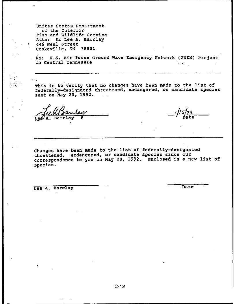
in 1992 and 1993 established that two new endangered plant species had been added
to the list and could occur in the project area: the leafy prairie clover (Dalea foliosa) and
the Tennessee yellow-eyed grass (Xyris tennesseensis) (Appendix C, Barclay, 1992,
1993 pages C-9, C-10, and C-12 of this EA).
The leafy prairie clover is a species of rocky hills, glades, and riverbanks (Fernald,
1950). The USFWS confirmed that the habitat of this clover is rocky sites (Widlak, 1992).
The Tennessee yellow-eyed grass, like the other species of this genus that occur in the
eastern United States, is a species of moist habitats. It is found at seeps, springs,
gravelly banks of small streams, and on moist slopes near seeps and springs (Widlak,
1992).
State-listed species that might occur in the project area include eight threatened or
endangered animal species and more than two dozen rare or endangered plant species.
The endangered species include the osprey (Pandion haliaetus), Bachman's sparrow
3-6
(Amophila aestivalis), and the barrens topminnow (Fundulus species). The threatened
species include the northern pine snake (Pituophis melanoleucus), Bewick's wren
(Thryomanes Bewickil), Cooper's hawk (Accipiter cooperii), the grasshopper sparrow
(Ammodramus savannarum), and the sharp-shinned hawk (Accipiter striatus). The listed
birds have a "probable or seasonal" occurrence in the area, primarily in the wetlands in
the northern portion of Arnold AFB and in the vicinity of Woods Reservoir. Most of the
listed plant species are indigenous wetland vegetation. Sinking Pond has eight types of
protected vegetation; Goose Pond nas eleven (TBG, 1989).
3.1.3 Socio-Cultural Setting
Excavations in the Duck River Valley in Coffee County have produced artifacts that date
as far back as the Late Archaic Period, 2,500 to 1,000 years B.C., indicating that humans
have occupied the region of Arnold AFB for more than 4,000 years (DuVall, 1990).
Native American inhabitants of central Tennessee in the late 1700s were the Shawnee
and Yuchi tribes; the Chickasaws occupied areas to the south and the Cherokees to the
east. Increasing pressure from Euro-American settlers eventually pushed these tribes
westward, and by 1805 much of the territory was carved up for permanent settlement.
The first Euro-American settlements in what is now Franklin County were at Rolling Fork,
near Cowan, and along Beans Creek. Itinerant frontiersmen from North Carolina,
Virginia, and Georgia were among the first immigrants. Other settlers received
homestead warrants for service in the Revolutionary War and came to begin a life of
farming. By 1820 the Nickajake Trail had been upgraded to become Unicoi Road, the
region's main turnpike and the route connecting Nashville, Tennessee, to Augusta,
Georgia (Billington, 1956). In the early 1800s the new railroad further increased
expansion and development in the area. The Tennessee Legislature created Franklin
County on December 3, 1807, and later part of the original county became Moore,
Coffee, Grundy, and Marion counties (SCS, 1958).
Arnold AFB was established in 1951. The State of Tennessee donated 33,000 acres to
the United States Air Force and an additional 7,000 acres were purchased from the local
3-7
community. Much of the donated area was Camp Forrest, a World War II training facility;
the remaining land was agricultural or forest land (Dunne, 1990).
The Tennessee State Historic Preservation Officer (SHPO) was consulted, as required
by the National Historic Preservation Act (16 USC 470, et seq.). Because of the area's
prehistoric activity, the Tennessee SHPO recommended that a Phase I archaeological
survey of the CGSs be conducted to identify archaeological resources (Appendix C,
Harper, 1990, page C-5 of this EA). In March 1990, a professional archaeologist
qualified in the State of Tennessee, surveyed each site using pedestrian transects at 5-
meter intervals. No significant archaeological resources were found on the sites (DuVall,
1990). The Archaeological Division of the Tennessee Department of Conservation has
information on five previously recorded prehistoric archaeological sites on Arnold AFB.
Local collectors found all of these sites along the Elk River, more than 10 miles from the
CGSs (TBG, 1989).
For reasons discussed in Section 4.8.1.3, beginning on page 4.8-2 of the FEIS and
Section 4.1.3 of this EA, historic properties that occur within 1.5 miles of a CGS are
potentially subject to adverse visual impacts from the relay node facility. No properties
on Arnold AFB are listed or eligible for listing on the National Register of Historic Places
(NRHP, 1988). Further investigation confirmed that there are no historically significant
properties within 1.5 miles of the Fire Tower (CGS-3) site (Appendix C, Hiebert, 1990,
page C-8 of this EA). The Tennessee SHPO concurred that construction at the Fire
Tower site will not affect properties which have been determined eligible for the NRHP
(Appendix C, Harper, 1990, page C-7 of this EA). A historic structures survey was not
conducted for the Camp Forrest (CGS-2) and UTSI Road (CGS-4) sites because of
conflicts with the FAA which preclude construction on these sites.
In compliance with the American Indian Religious Freedom Act of 1978 (42 USC 1996),
the Bureau of Indian Affairs (BIA) was consulted in order to locate tribes associated with
the project area. The BIA indicated that no federally recognized tribes currently live in
Tennessee. The only federally recognized tribe that was historically in the area is the
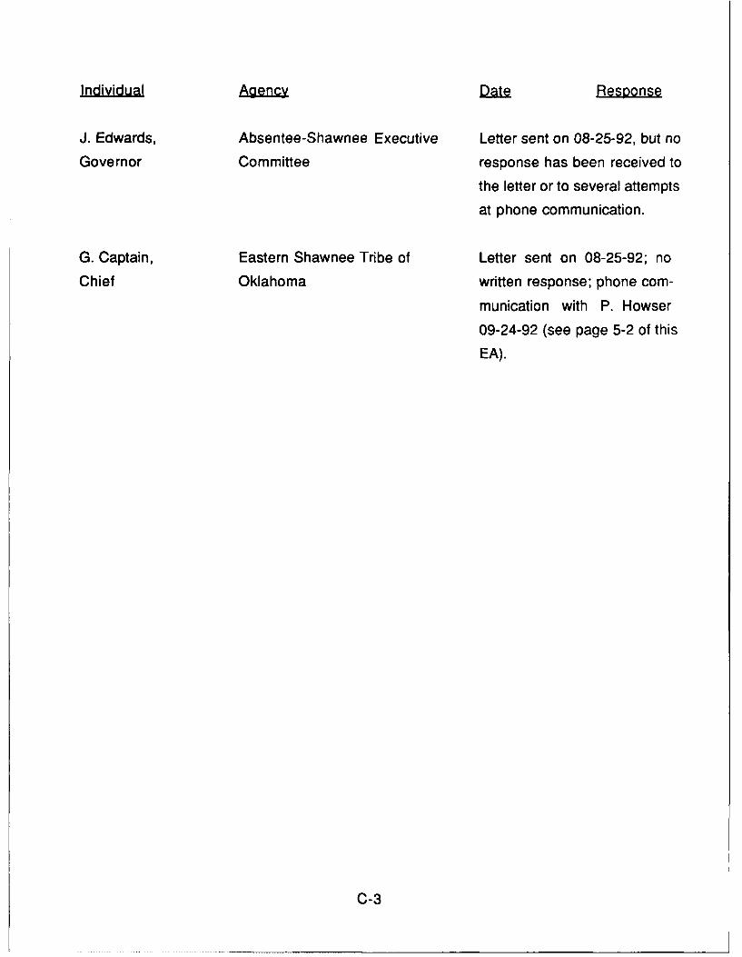
Shawnee (Sutherland, 1992). Based on BIA recommendations, the Absentee-Shawnee
Executive Committee in Oklahoma and the Eastern Shawnee Tribe of Oklahoma were
3-8
notified of the GWEN project and information was requested regarding traditional,
religious, or sacred sites within the SSA. A representative of the Eastern Shawnee Tribe
of Oklahoma stated that the tribe has no concerns with the GWEN project in central
Tennessee (Howser, 1992). No response has been received to letters or several
attempts at phone communication from the Absentee-Shawnee Executive Committee in
Oklahoma. Information was also requested from the Tennessee Commission on Indian
Affairs. The Commission indicated that no traditional, religious, or sacred sites exist on
any CGS (Butler, 1990).
Development on Arnold AFB, associated primarily with the AEDC, an aerospace
technology research center, is clustered in the flat central portion identified on geological
survey maps as "The Barrens." Many buildings, including a lookout tower, water tank,
electrical substation, water filtration plant, and office and administrative buildings, are
within the AEDC compound. Development in the remaining area is limited to officers
quarters, recreation facilities, parks, camps, and the UTSI, all near Woods Reservoir.
Land use on Arnold AFB is primarily related to Air Force activities; however, portions of
the land have been leased to local farmers through the Tennessee Fish and Game
Commission to improve the soil and to increase wildlife habitats. This acreage is planted
with corn, soybeans, buckwheat, and millet.
The major road within Arnold AFB is Arnold Center Road, which connects with U.S.
Highway 41A at Tullahoma to the west, crosses the center of Arnold AFB, then turns
northeast to tie into U.S. Highways 24 and 41 in the northeast portion. The UTSI Road
runs north-south between Arnold Center Road and Woods Reservoir. Several
secondary roads branch off from the main roads and provide access to more remote
areas of Arnold AFB. The Air Force maintains the roads.
The AEDC access railroad tracks parallel Arnold Center Road and end at the office and
administrative compound. These tracks tie into the Louisville and Nashville Railroad
system in Tullahoma. Arnold Airfield to the west of the administrative compound isprimarily used to test experimental jet aircraft but also allows for the transportation of
equipment and personnel.
3-9
Ambient noise levels are an important element of Arnold AFB/AEDC operations,
because of the airport and rocket engine-testing facilities. However, noise generated by
testing is not considered significant outside of the testing facilities, because it does not
exceed Occupational Safety and Health Administration (OSHA) established standards.
Arnold AFB is exempt from Air Installation Compatible Use Zone regulations because of
the low volume of air traffic and the distance from sizeable population and business
centers. The operations at Arnold AFB are not currently affected by any state, local, or
Environmental Protection Agency (EPA) noise regulations or restrictions (TBG, 1989).
The populations of Coffee and Franklin counties in 1986 were 41,300 and 33,700,
respectively, with a 6 percent increase since 1980 (Census Bureau, 1988a). This
population is concentrated in the communities of Tullahoma, Manchester, Estill Springs,
Winchester, Monteagle, Cowan, Normandy, Sewanee, and Decherd. The majority of
AEDC personnel resides within 10 miles of Arnold AFB boundaries and is heavily
concentrated in the cities of Tullahoma, Manchester, and Winchester (TBG, 1989).
Tullahoma and Manchester are the two largest population concentrations with 16,780
and 7,630, respectively, in 1986 (Census Bureau, 1988a).
Per capita income for the combined areas of Coffee and Franklin counties equaled
$8,695 in 1985, below the state figure of $9,290 and the national figure of $10,800. In
1986, 8.4 percent of the salaried labor force from the area was unemployed, slightly
higher than the statewide figure of 8 percent and the national figure of 7 percent. In
1982, close to 50 percent of the combined land area of both counties was used for
agricultural farming (Census Bureau, 1988b).
The economies of Coffee and Franklin counties are closely related to the performance of
Arnold AFB. As the area's primary employer, Arnold AFB's annual payroll totaled $150
million in 1988 (TBG, 1989). Manufacturing is the region's second largest source of
employment. Tullahoma, for example, is home to the Cleveland Pneumatic Company,
the Tennessee Apparel Corporation, the Wilson Sporting Goods Company, the Coca
Cola and Dr. Pepper Bottling Company, and the Lannom Manufacturing Company.
3-10
Manchester manufacturers include the Batesville Casket Company, PCA Apparel
Industries, Eden Industries, and Parks Industries (TBG, 1989).
Recreational resources within Arnold AFB are primarily concentrated in the Woods
Reservoir area. Fishing and water sports are popular activities among both Air Force
personnel and the local civilian population. The reservoir is accessible to the general
public. The south shore has numerous picnicking facilities as well as one county-
managed camping facility. Arnold AFB's recreational facilities are generally limited to
base personnel and include a golf course, hiking trails, and model airplane field, all
located off Arnold Center Road just east of Tullahoma.
Old Stone Fort State Park and Lake Normandy are 7 miles northwest of Arnold AFB.
Tim's Ford State Park and Lake are approximately 7 miles southwest. Both of these
facilities allow for camping, hiking, and water sports.
The visual setting is rural in character. Except for the hilly area around Woods Reservoir,
the topography of Arnold AFB is fairly level and the landscape offers no noticeable visual
pattern. Much of the land is forested with tall pine and oak stands which act as barriers
to views from outside Arnold AFB. Vacant barracks, industrial facilities, water towers, the
fire lookout tower, high-power transmission lines, and radio antennas are concentrated
along either the Arnold Center Road or the UTSI Road. Depending on the direction of
view, the complexity of the skyline varies from low to high, as defined in Section 4.8.1.3,
page 4.8-10 of the FEIS.
3.2 Alternative 1: Camp Forrest Site (CGS-2)
The site is part of the old Camp Forrest, which was a U.S. Army training facility during the
1930s and 1940s (Dunne, 1990). Virtually none of the original structures in the area is
still standing; however, many of the original paved and gravel roadways remain, creating
a cross-hatching configuration. An industrial area is currently operative northwest of the
site and contains a 100-foot-tall metal water storage tank that stands approximately
1,750 feet from the site.
3-11
The site is on level ground with 0 to 1 percent slope. It has been planted with pine trees
within the past five years. These trees, along with other vegetation, have heights of 1 to
8 feet. The site is screened on all four sides by mature pine forest with stands reaching
heights of 50 to 60 feet. No rare or old growth vegetation is present.
The nearest surface water is 0.3 mile northeast of the site. No soil erosion, collapse, or
settlement was observed during the on-site investigation.
The presence of potentially eligible historic properties within 1.5 miles of this site is
unknown. Since the site has conflicts with the FAA which preclude construction of a
tower on this site, a survey to identify potentially eligible properties was not conducted.
The closest community is Tullahoma, with its nearest residential area located
approximately 0.6 mile southwest of the site.
3.3 Alternative 2: Fire Tower Site (CGS-3)
The site is part of a parcel leased by the Air Force to local farmers through the
Tennessee Fish and Game Commission under the Wildlife Management Plan (Dunne,
1989). Corn rows are planted in swirls around the clusters of trees and shrubs that dot
the field, and the surrounding vegetation is thick pine forest and brush.
The site, located in the center of the leased field, is fairly level, though a slight downward
slope to the east provides natural drainage. The nearest surface water is a small
seasonal pond, surrounded by a cluster of trees, located 200 feet from the eastern
boundary. The pond, approximately 1 foot deep and 10 feet in diameter, appears to
collect rainwater from about a 100-yard radius around the site but does not support
vegetation or aquatic life. A dry streambed slopes downward from the pond toward the
southeastern corner of the field, handling pond overflow during heavy rains. According to
USGS topographical maps, the stream is a tributary of Spring Creek, which is more than
2.5 miles southeast of the CGS.
3-12
There are no NRHP-listed or eligible properties within 1.5 miles of this site (NRHP, 1988;
Appendix C, Hiebert, 1990, page C-8 of this EA).
The closest residential community is Tullahoma, 2.2 miles to the west.
3.4 Alternative 3: UTSI Road Site (CGS-4)
This site occupies roughly half of a parcel of cleared forest. The terrain is fairly level with
a high point in the center of the site, at the proposed tower base. The slope from the
center is toward the east, the lowest point being on the northeastern corner.
Surrounded by thick, mature pine forest on all sides with a meadow extending from the
southeastern corner, the site was cleared some years ago and contains the remains of
downed trees acrd overgrown shrubbery. In the site-clearing process, power saws were
used to cut the trees at ground level and the stumps and root systems were never
removed. Many of these stumps have rotted, are brittle, and would have to be removed
to accommodate the ground plane.
Although the CGS has no surface water, an intermittent stream runs through the trees
adjacent to the northern and eastern boundaries. The stream crosses under the UTSI
Road roughly 60 feet from the site's northern boundary and continues to the northeastern
corner where, at the time of the field investigation, it formed an area of standing water
approximately 100 feet from the corner of the site. The depth of the standing water did
not exceed 3 inches and its surface level was 4 feet below the elevation of the proposed
tower base. The stream makes a 90-degree turn and flows along the eastern edge of the
site, approximately 100 feet from the boundary line. According to the USGS
topographical map, ihe stream then flows toward the southwest for 1.25 miles and enters
Rollins Creek 2 miles upstream from Woods Reservoir. Despite the presence of standing
water, the soils within 300 feet of the site are not hydric soils, and no hydrophytic
vegetation was observed within 300 feet of the site (Kroupa, 1989). Consequently, no
wetlands are present on or within 300 feet of the site.
3-13
The presence of potentially eligible historic properties within 1.5 miles of this site is
unknown. Since the site has conflicts with FAA flight safety requirements which preclude
construction of a tower on this site, a survey to identify potentially eligible properties was
not conducted.
The closest residential community is Tullahoma, 4.5 miles to the west.
3-14
4.0 ENVIRONMENTAL CONSEQUENCES OF ACTION ALTERNATIVES
This section discusses the potential impacts of the GWEN project on the environmental
setting of the three CGSs in central Tennessee. Several impacts which would be
common to all of the action alternatives are discussed in Section 4.1 of this EA. Impacts
that are unique to each action alternative are discussed in Sections 4.2 through 4.4 of
this EA. The project would have significant visual impacts if built on the Camp Forrest
site (CGS-2), as indicated in Section 4.2 of this EA. Impacts to historic properties are
unknown on the Camp Forrest (CGS-2) and UTSI Road (CGS-4) sites, and impacts on
water quality are unknown on the UTSI Road (CGS-4) site. These sites conflict with FAA
flight safety requirements which preclude construction of a tower on these sites and
studies were not completed, as discussed in Sections 4.2 and 4.4 of this EA. There
would be no significant impacts on the Fire Tower site (CGS-3), as indicated in Section
4.3 of this EA.
4.1 Common Features
Presented below is information on the physical, biological, and socio-cultural impacts
common to all of the action alternatives. None of these common impacts would be
significant.
4.1.1 Physical
Impacts from construction activities would not be significant. Construction would
require localized earth-moving, including excavation and backfilling for placement of
foundations and guy-wire anchors. Less than 3,800 square feet would be covered with
concrete and gravel for the tower base and the equipment area enclosures. Similar
coverage would be required for on-site access roads and parking; incidental activities
during construction would disturb a similar amount. In total, about 0.25 acre would be
occupied by foundations and the on-site access roads. Construction of the off-site
access road and installation of utility lines would have no significant impacts because
they would cover no more than 700 square feet of land at any site and would be along
previously graded USAF roads.
4-1
The ground plane would be installed using machines that bury wire approximately 1 foot
below the surface with minimal disturbance of the soil surface. This process would
require moving a small tractor or similar equipment over much of the 11-acre site, but
would not significantly disturb the existing vegetation or create a significant erosion
hazard.
Impacts on mineral resources would be minor, as indicated in Section 4.1.1.4, page
4.1-2 of the FEIS. There are no economic mineral deposits known at Arnold AFB or
vicinity (TBG, 1989). If any mineral resources are present under a site, development of
the site would only deny access to a small portion of those resources for the lifetime of
the project and would not result in any significant impacts.
Impacts on paleontological resources would not be significant. No significant
paleontological resources are known to occur on any CGS, as discussed in Section
3.1.1 of this EA. However, if any fossils are found during construction, work that might
affect them would be suspended while the Tennessee Geological Survey Bureau is
notified and the significance of the find is evaluated.
Erosion and Increase in storm water runoff would not be significant. All sites
have slopes that do not exceed 1 percent, so any required grading to level the site would
be minimal. In addition, standard measures for erosion control would be used during
and after site construction, including replanting the site.
None of the sites is located in a 100-year floodplain (FEMA, 1978).
No prime farmland would be removed from production for the project, as the soils on
the sites are not classified as prime farmland (TBG, 1989).
No significant impacts on drinking water are expected, as discussed in Sections
3.2.4.1 and 4.2.1.1, pages 3.2-2 and 4.2-3 of the FEIS. Corrosion of the ground plane is
not anticipated to raise copper concentrations in any aquifer or surface water body by
more than 20 micrograms per liter (Jgg/I). This would represent 2 percent of the maximum
4-2
allowable copper concentrations permitted by the State of Tennessee for raw water
sources for potable water supply (Tennessee Administrative Code, Title 69, Chapter
1200-4). The Tennessee standard is the same as the Environmental Protection Agency
(EPA) standard, which is intended to maintain the aesthetic properties that relate to
public acceptance of drinking water and is not related to public health. A threshold for
the effects of copper on human health has not been determined (EPA, 1985).
Impacts on surface water or wetlands that support aquatic plants and animals are
unknown on the UTSI Road site (CGS-4). This site has conflicts with the FAA which
preclude construction of a tower. Therefore, the Tennessee Division of Water
Management (TDWM) was not requested to comment on copper leachate impacts at
CGS-4. Impacts on the Camp Forrest and Fire Tower sites (CGS-2 and CGS-3) would
not be significant. Potential impacts from copper leachate could occur when the site is
less than 300 feet from surface water or wetlands, if the soil is acidic, or the depth to the
seasonally high water table is less than 3 feet from the ground plane (4 feet from the
surface), as discussed in Section 4.2.1.1, page 4.2-3 of the FEIS. The Camp Forrest Site
(CGS-2) is not within 300 feet of surface water, therefore the increase in copper
concentrations would be insignificant, as discussed in Section 4.2.1.1, page 4.2-3 of the
FEIS. Although the Fire Tower site (CGS-3) is within 300 feet of surface water, the
TDWM has determined that there would be no significant impacts.
Impacts on air quality would not be significant. Temporary but insignificant increases
in air pollutant emissions would occur during construction, primarily from the use of
heavy machinery. During operation of the BUPG at 100 percent load, total yearly
emissions from the BUPG would be less than 350 pounds per pollutant, as described in
Section 2.1.2 of this EA. These are well below the standards set by the Clean Air Act (42
USC 7401, et seq.), which requires permits for facilities emitting any single regulated
substance at the rate of 50 tons per year. Hence, the project would not result in violation
of National Primary and Secondary Ambient Air Quality Standards, which have been
adopted by the State of Tennessee (Tennessee Administrative Code, Title 68, Chapter
1200-1).
4-3
4.1.2 Biological
Impacts on biological resources would not be significant. The Camp Forrest site
(CGS-2) is currently a field of young pine trees. The Fire Tower site (CGS-3) is an
agricultural field planted with row crops. The UTSI Road site (CGS-4) was clear cut and
has been replanted with pine trees. Each site is at least 2 miles from any lakes or rivers
(USGS, 1982a-b). No critical or exceptionally valuable wildlife habitats would be at risk
or would be close enough to attract waterfowl or other wildlife to the tower's vicinity.
No federally listed threatened or endangered species would be adversely affected.
This determination was made after consultation with the USFWS in compliance with
Section 7 of the Endangered Species Act of 1973, as amended (16 USC 1531 et seq., at
1536) (Appendix C, Barclay, 1992, 1993 pages C-9 to C-10 and C-12 of this EA). The
only species cited by the USFWS as possibly occurring in the SSA are the leafy prairie
clover and the Tennessee yellow-eyed grass, both endangered (Appendix C, Barclay,
1992, 1993 pages C-9 to C-1 0 and C-1 2 of this EA). The habitats for these species are
not found on the CGSs. The leafy prairie clover requires rocky sites and the Tennessee
yellow-eyed grass requires moist sites. The CGSs contain no springs, streams, or wet
areas and they are either agricultural fields or are planted with trees. The USFWS
concurs that the project would cause no adverse effects to these species (Appendix C,
Barclay, 1992, page C-i 1 of this EA). The species listed by the state of Tennessee as
rare, threatened, or endangered are in portions of Arnold AFB not affected by this project
and would not be impacted (TBG, 1989).
Bird collisions with the tower may occur but are not expected to be significant.
Section 4.4.1.5, page 4.4-5 of the FEIS states that the majority of bird collisions occur in
adverse weather conditions when the visibility of man-made structures is obscured and
birds are forced to lower their flight level. Generally, songbirds (passerines) are more
likely to collide with a tower or the guy wires than are raptors or waterfowl (Avery et aL,
1980). Areas with high concentrations of bird flight activity, prominent topographical
features that could serve as navigational aids, known migration corridors, and raptor
roosting areas, were avoided. High tree lines and thick forest around the sites will also
aid in the prevention of guy-wire collisions. Although the area around the Fire Tower
4-4
site (CGS-3) is planted with corn as part of the wildlife program, the cornfield's distancefrom Woods Reservoir and other wetlands indicates that the species most likely to forage
there are upland species not on the federal or state threatened or endangered species
lists.
The northern wetlands area of Arnold AFB is at least 4.5 miles from the UTSI Road site
(CGS-4), 6 miles from the Fire Tower site (CGS-3), and 6.5 miles from the Camp Forrestsite (CGS-2). Woods Reservoir is at least 2 miles from the UTSI Road site (CGS-4), 4.5
miles from the Fire Tower site (CGS-3), and 6 miles from the Camp Forrest site (CGS-2).
Each site is therefore outside the primary foraging zone that surrounds these two critical
and/or exceptionally valuable habitats. Waterfowl enter and leave these areas from all
directions and show no preferred migratory path. Although Elk River is a minor migratory
flyway, it is more than 2 miles to the south of the UTSI Road site (CGS-4), 5 miles
southeast of the Fire Tower site (CGS-3), and 6.5 miles from the Camp Forrest site (CGS-2); the GWEN facility would therefore not pose a significant hazard to migratory birds.
4.1.3 Socio-Cultural
Local employment would be increased slightly, primarily through use of local
subcontractors for earth-moving and possibly for some of the facility's maintenance.
Impacts on community support systems would not be significant because the relay
node will be unmanned and will use modest amounts of power (comparable to that used
by an average single-family house). Security needs will be met by Arnold AFB security
personnel who will monitor the integrity of the site during routine patrols, as detailed in
Section 4.6.1.1, page 4.6-1 of the FEIS.
Impacts on land use would not be significant. Each candidate site is unzoned
government-owned land, and a GWEN facility would be compatible with the surroundingland use (Dunne, 1989). Care was taken in the site selection process to maintain
setbacks from institutional uses such as schools, churches, recreational areas, and
areas zoned residential. The tower would not significantly affect property values
because non-noxious, nonresidential land uses, such as the proposed relay node, have
4-5
no systematic effect on housing values, as stated in Section 4.7.1.3, page 4.7-8 of the
FEIS.
Construction noise impacts would be temporary and insignificant. Operational noise
from the backup generator would be less than 72 dBA at the site boundary. At 50 feet
beyond the site boundary the noise level would drop below 65 dBA, as discussed in
Section 2.1.2 of this EA. The operations at Arnold AFB are not currently affected by any
state, local, or EPA noise regulations or restrictions (TBG, 1989), and no CGS has
residences within 50 feet of the site boundary.
Impacts on public health and safety would not be significant, as discussed in
Sections 4.11 and 4.12 of the FEIS beginning on pages 4.11-1 and 4.12-1, respectively,
of the FEIS. Shock and burn risks would be associated with the buildup of electrical
charges on ungrounded metallic objects inside the inner exclusionary (8-foot) fence
located approximately 20 feet from the tower base. However, a grounded person within
the outer exclusionary (4-foot) fence located approximately 330 feet from the tower base
who touches an ungrounded object while the tower was transmitting would experience
only a mild shock, sufficient to cause the individual to break contact but not cause harm.
Furthermore, because the transmission periods would total between 6 and 8 seconds
per hour during normal operations, the risk of even these mild shocks would be
insignificant. Only a determined effort to enter the inner exclusionary zones, within the 8-
foot fence, would put a person at increased risk of higher shock and a higher specific
absorption rate, dependent on the period of prolonged grasping contact with an
ungrounded metallic object. Fire hazards at the relay node facility would be low, as
discussed in Section 4.12.1.1, page 4.12-1 of the FEIS. Radio-frequency emissions
would not cause adverse health effects as described in Section 4.4.1.6, pages 4.4-6 and
4.4-7 of the FEIS. Subsequent to the publication of the FEIS, further study confirmed the
conclusion of the FEIS that there is no evidence of adverse effects of GWEN radio-
frequency emissions on public health (NRC, 1992).
The relay node would operate in the LF band and therefore would not interfere with
pacemakers, emergency communications, commercial and amateur radios, televisions,
or garage door openers, as noted in Section 2.1.1.1, page 2-3 of the FEIS.
4-6
Impacts on archaeological resources would not be significant. An on-site
archaeological survey identified no archaeological resources on any of the sites (DuVall,
1990). The Tennessee SHPO has concurred with this determination (Appendix C,
Harper, 1990, page C-6 of this EA). The five previously recorded prehistoric
archaeological sites along the Elk River are all more than 10 miles from any site (TBG,
1989). If any archaeological resources are found during construction, work that might
affect them will be suspended while the Tennessee SHPO is notified in accordance with
the provisions of 16 USC 470, et seq, at 470f.
Impacts on historic properties would not be significant. No properties that are listed
or eligible for listing on the NRHP occur within 1.5 miles of any of the CGSs (NRHP,
1988). The Tennessee SHPO has concurred that construction of a tower on the Fire
Tower site (CGS-3) will not affect properties which have been determined eligible for the
NRHP (Appendix C, Harper, 1990, page C-7 of this EA; Appendix C, Hiebert, 1990, page
C-8 of this EA). An historic structures survey of the Camp Forrest (CGS-2) and UTSI
Road (CGS-4) sites was not conducted because of conflicts with FAA flight safety
requirements. Impacts from these two CGSs are therefore unknown.
Significant impacts to Native American traditional, religious, or sacred sites are
not anticipated. The BIA indicated that no federally recognized tribes currently live in
Tennesssee and that the Shawnee are the only federally recognized tribe that
historically occupied the area (Sutherland, 1992). The Absentee-Shawnee Executive
Committee in Oklahoma and Eastern Shawnee Tribe of Oklahoma were notified of the
GWEN project and information was requested regarding traditional, religious, or sacred
sites within the SSA. A representative of the Eastern Shawnee Tribe of Oklahoma stated
that the tribe has no concerns with the GWEN project in central Tennessee (Howser,
1992). No response to letters or phone calls has been received from the Absentee-
Shawnee Executive Committee in Oklahoma. The Tennessee Commission on Indian
Affairs indicated that no traditional, religious, or sacred sites exist on any CGS (Butler,
1990).
4-7
Visual impacts associated with a GWEN tower are discussed in Sections 3.8 and 4.8,
pages 3.8-1 and 4.8-1, respectively, of the FEIS. The significance of a visual impact
would depend on the visual dominance of the GWEN facility and the sensitivity of the
affected views. Visual dominance is the degree to which a GWEN facility would compete
with other features of the existing landscape for the attention of the viewer. Section
3.8.4, beginning on page 3.8-3 of the FEIS defines four levels of dominance, called
Visual Modification Classes (VMC):
• VMC 1, not noticeable: the tower would be overlooked by all but the
most interested viewers
• VMC 2, noticeable, visually subordinate: the tower would be
noticeable to most viewers without being pointed out but would not
compete with other features for their attention
"° VMC 3, distracting, visually codominant: the tower would compete
with other features in the landscape for the viewers attention
"* VMC 4, visually dominant, demands attention: the tower would be
the focus of the attention and tend to dominate the view.
Visual sensitivity is a measure of the public's reaction to a proposed change of the
affected view and is a function of the viewers activity, awareness, goals, and values.
Consequently, the more sensitive the view, the stronger will be the public reaction to any
alteration of it. Areas defined in the FEIS as having high visual sensitivity include
national and state parks; designated scenic routes; designated national, state, or local
historic sites where setting is important to their historic significance; and travel routes
providing primary access to these sites. Examples of areas having medium visual
sensitivity would be locally popular, but undesignated, beaches or public use areas, and
travel routes that provide primary access to them. Low visual sensitivity includes those
views from sites, areas, travel routes, and sections of travel routes not identified as
medium and high in sensitivity.
4-8
Significant visual impacts would occur if the relay node facility were to dominate or
codominate (VMC 4 or 3) a high-sensitivity view or dominate (VMC 4) a medium-
sensitivity view. If the relay node facility cannot be seen from medium-to-high sensitivityroutes or areas, then visual impacts are not considered significant. Distance is the
primary factor in determining visual dominance and therefore visual impacts. At
distances greater than 3 miles, a GWEN tower would not be visible to the unaided eye.
At 1.5 to 3 miles, the tower would be visually subordinate if noticeable (VMC 2) but more
usually would not be noticed (VMC 1) because of its grey color and lack of mass. If a
viewer at this distance actively sought the tower, it would appear as a thin vertical line on
the horizon. Within 1.5 miles, the tower becomes a more important component of theview. In addition, other aspects of the towers setting, such as focal point sensitivity,
skyline complexity, competing feature interest, and topographic and vegetative
screening, become important considerations in determining the level of visual impact.
USGS topographic maps and a windshield survey were used to determine whether high
or medium sensitivity views were within 1.5 miles of the CGSs. The visual impacts
associated with each site are discussed in Sections 4.2 to 4.4 of this EA.
4.2 Alternative 1: Camp Forrest Site (CGS-2)
Significant impacts are expected.
Visual impacts would be significant. The corporate city limits of Tullahoma are 0.2 mile
west of the site, and the nearest residential area, a potentially high sensitivity view, is
approximately 0.6 mile from the site boundary. The site is surrounded on all four sides
by mature pine forest with stands reaching heights of 50 to 60 feet. In the view of the
tower from the residential area to the southwest, these trees would screen the lower two
thirds of the tower. The low skyline complexity above the tree line and the lack of
competing feature interest would cause the upper third of the tower to be distracting
(VMC 3), and the visual impacts on this residential area would therefore be significant.
4-9
Impacts on surface water or wetlands would not be significant because the site is
more than 300 feet from surface water.
Impacts un historic properties are unknown. Since the site has conflicts with the FAA
which preclude construction of a tower, an historic structures survey was not considered.
4.3 Alternative 2: Fire Tower Site (CGS-3)
No significant impacts are expected.
Impacts on surface water or wetlands would not be significant. A small seasonal
pond and an intermittent stream are within 300 feet of the site, the soils are acidic, and
the depth to the seasonally high water table is less than 2 feet. However, the TDWM has
concurred that impacts from potential copper leachate into these intermittent surface
waters would not be significant (Holland, 1990), because their periodic nature makes
them unsuitable habitats for fish. The small amphibians, planktonic plants and animals,
and aquatic flowering plants that these surface water sources might support are common
and widely dispersed, and only small numbers of these species would be exposed to
copper leachate.
Impacts on historic properties would not be significant. The Tennessee SHPO
determined the project would not affect properties which have been determined eligible
for listing on the NRHP (Appendix C, Harper, 1990, page C-7 of this EA).
Visual impacts at this site would not be significant. No medium or high sensitivity views
occur within 1.5 miles of the site.
4.4 Alternative 3: UTSI Road Site (CGS-4)
Complete impacts are unknown.
4-10
Impacts on water quality are unknown. Since the site has conflicts with the FAA which
preclude construction of a tower, the TDWM was not requested to comment on copper
leachate impacts.
Impacts on historic properties are unknown. Because of the FAA conflicts, an historic
structures survey was not considered.
Visual impacts would not be significant because there are no medium or high sensitivity
views within 1.5 miles of the site.
4.5 No Action Alternative
No environmental impact would result from adoption of the no action alternative.
4-11
5.0 REFERENCES
Avery, M., P.F. Springer, and N.S. Dailey, 1980. Avian Mortality at Man-made
Structures: An Annotated Bibliography. U.S. Fish and Wildlife Service.
Billington, R.A., 1956. Westward Expansion, A History of the American Frontier. The
Macmillan Co., New York, New York.
Butler, L., 1990. Personal communication from L. Butler, Director, Department of
Conservation, Tennessee Commission on Indian Affairs, to P. Kroupa, SRI International,
June 20, 1990.
Census Bureau, 1988a. County and City Data Book, 1988. U.S. Dept. of Commerce,
Bureau of the Census.
Census Bureau, 1988b. County Business Patterns, 1988. U.S. Dept. of Commerce,
Bureau of the Census.
Dunne, W.M., 1989. Personal communication from W. Dunne, Director of Environmental
Planning, Arnold Engineering Development Center, to P. Kroupa, SRI International,
November 28, 1989.
Dunne, W. M., 1990. Personal communication from W. Dunne, Director of Environmental
Planning, Arnold Engineering Development Center, to P. Kroupa, SRI International, May
21, 1990.
DuVall, 1990. An Archaeological Reconnaissance of the Proposed Ground Wave
Emergency Network Tower Locations... Coffee and Franklin Counties, Tennessee.
DuVall and Associates, Cultural Resources and Environmental Services, Nashville,
Tennessee.
EPA, 1985. Ambient Water Quality Criteria for Copper. Standards, Criteria and
Standards Division. Office of Water Regulations, Washington, D.C.
5-1
FEMA, 1978. Flood Insurance Rate Map. Federal Emergency Management Agency,
Franklin and Coffee Counties, Tennessee, 1978.
Fernald, M.L., 1950. Gray's Manual of Botany. American Book Company, New York,
New York.
FICWD, 1989. Federal Manual for Identifying and Delineating Jurisdictional Wetlands.
U.S. Army Corps of Engineers, U.S. Environmental Protection Agency, U.S. Fish and
Wildlife Service and USDA Soil Conservation Service, Washington, D.C., Cooperative
Technical Publication.
Holland, J.E., 1990. Personal communication from J.E. Holland, Manager, Nashville
Basin Office, Division of Water Pollution Control, Nashville, Tennessee, September 20,
1990.
Howard, K.A., et al., 1979. Preliminary Map of Young Faults in the United States as a
Guide to Possible Fault Activity. USGS Map MF-916.
Howser, P., 1992. Personal communication from P. Howser, Business Manager, Eastern
Shawnee Tribe of Oklahoma, to H. Mendel, SRI International, September 24, 1992.
Kroupa, P., 1989. Field investigation conducted by P. Kroupa, SRI International,
December 7, 1989.
Manitakos, Jr., J., 1989. Personal communication from J. Manitakos, Jr., Consultant, SRI
International, to F. Dutcher, Program Manager, Contel Federal Systems, Inc., May 10,
1989.
NFS, 1977. Vegetation and Environmental Features of Forest and Range Ecosystems.
National Forest Service, U.S. Department of Agriculture.
5-2
NRC, 1992. An Assessment of the Possible Health Effects of the Ground Wave
Emergency Network. National Research Council, National Academy Press, Washington,
D.C.
NRHP, 1988. National Register of Historic Places Index by Property Location. National
Park Service, U.S. Department of the Interior, May 24, 1988.
Reagor, B.G., et al., 1987. Seismicity Map of the State of Tennessee. USGS Map MF-
1157.
SCS, 1958. Soil Survey, Franklin County Tennessee. Soil Conservation Service, U.S.
Department of Agriculture.
SCS, 1987. Hydric Soils of the United States. Soil Conservation Service, U.S.
Department of Agriculture, December 1987.
Stover, C.W., 1986. Seismicity Map of the Conterminous United States and Adjacent
Areas, 1975-1984. USGS Map GP-984.
Sutherland, D., 1992. Personal communication from D. Sutherland, Bureau of Indian
Affairs, Washington, D.C., to L. Forbush, SRI International, August 12, 1992.
TBG, 1989. Draft Environmental Assessment for the Base Comprehensive Plan. Arnold
Air Force Base, Tennessee. The Benham Group, St. Louis, Missouri.
USGS, 1970. National Atlas of the United States of America. U.S. Geological Survey.
USGS, 1972a. 7.5' Series. Manchester Quadrangle, Tennessee. U.S. Geological
Survey.
USGS, 1972b. 1:250,000 Scale Topographical Map. Chattanooga, Tennessee; North
Carolina Quadrangle. U.S. Geological Survey.
5-3
USGS, 1976. 7.5' Series. Normandy Lake Quadrangle, Tennessee. U.S. Geological
USGS, 1982a. 7.5' Series. Tullahoma Quadrangle, Tennessee. U.S. Geological
Survey.
USGS, 1982b. 7.5' Series. Capitol Hill Quadrangle, Tennessee. U.S. Geological
Survey.
USGS, 1983a. 7.5' Series. Alto Quadrangle, Tennessee. U.S. Geological Survey.
USGS, 1983b. 7.5' Series. Hillsboro Quadrangle, Tennessee. U.S. Geological Survey.
Waynick, J., 1989. Personal communication from J. Waynick, Air Quality Specialist, Air
Pollution Control Division, Tennessee Department of Health and Environment, Nashville,
Tennessee, to B. Holt, SRI International, November 16, 1989.
Widlak, J., 1992. Personal communication from J. Widlak, Botanist, U.S. Fish and
Wildlife Service, Cookeville, Tennessee, to B. Holt, SRI International, August 6, 1992.
5-4
APPENDIX A
SITE SELECTION PROCESS
A-1
SITE SELECTION PROCESS
Figure A.1 of this EA shows the sequence of events during the selection of individual
GWEN sites. Figure A.2 of this EA describes the screening process used during the field
investigation to choose the candidate GWEN sites (CGSs). The environmental siting
criteria applied in the site selection process are defined in Tables 5-1 and 5-2, pages 5-7
through 5-14 of the FEIS.
A-2
Coordination,Studies and Field Consultation, and
investigations Milestones Public Information
NetworkDevelopment
I
Identify NominalCoordinates for
Relay Nodes Define Site SearchArea as 9-Mile Radius
Condut Des-TopAbout CoordinatesonutDesk-Top
Appicanu n of
CteaIdentify Potenal
Areawida SitesNoiyBcd(P A W S ) N tf l c e
Officials and ContactAgencies for
Update PAWS Information
Based onAgency inputs
Conduct Field
Investigations/Site Search
Identify
CandidateGWEN Sites
Conduct Operational
Studies and LandAcquisition Evaluation
PreparePreliminary
Site Evaluation Coordinate PreliminaryReport (PSER) Report Informally with
Regional, State, and[nert O~r*W Local Agencies andEnvironmental, LandOfial
Agecyuisimtion, nA c Prepare EA, FONSI,
and Preferred GWENSilo Report (PGSR)
f ~Selection FormallySe " Through IICEP"
Select GWEN ite
"IICEP . lnbragency/Inbrgovemmentai Coordination for Environmental Planning.
FIGURE A.1 GROUND WAVE EMERGENCY NETWORK SITE SELECTION PROCESS
A-3
8 potential candidate GWEN sites were identified.
4 sites we dropped because the Air Force found them unsuitable. ]I site was rejected because it was incompatible with the FEIS siting criteria.J
3 candidate GWEN sites remain.
FIGURE A.2 RESULTS OF USING FEIS SITING CRITERIA TO SCREENPOTENTIAL CANDIDATE GWEN SITES IN THE CENTRALTENNESSEE SITE SEARCH AREA
A-4
APPENDIX B
TOPOGRAPHIC SETTINGS OF CANDIDATE GWEN SITES
B-1
0.5 0.5Ml
100 0 100 200 000 400 500 ee
_____1
1h 0.F01 nlmee
FIGURE~~~~~~~~~bks s. OORPI ETN FTel CMlORS ST CS2
COPY~ ~ \0IAL VDI DE O 2R&TFUL EIL 7"de A
1%
0A~
~~ : i'b,- ~
-. . 'K
0.5' 0u 0. M0e
1000 0 00 200 30 00 00Fe
d . ioee 1
FIGUE B2 TOOGRPHI SETINGOF HE FRE OWE SIT (CSM3
L~ PY INLBL AO., OS O EM~FUL EIL RRDCIB-
BASE MAW SOURCE: U.S. GEOLOGICAL SURVEY. 1972 Caia ONw -20 Foul(PHOTOREVISED 19M2 CAPITAL HILL GUADRANGLE Neuioal GomdoWi Vookel Oswun dl 1i7.5 MJTE SERIES (TOPOGRAPHIC)
SCALE 124,0000.5 0 0.5 MileN
1000 0 1000 2000 3000 4000 5000 Feet
1 0.5 0 1 Kilometer
FIGURE 6.3 TOPOGRAPHIC SETTING OF THE UTSI ROAD SITE (CGS-4)
My AVAILABLE TO DTIC DOES NOT PERMrT FULLY LEGIBLE REPROAd 7,CMT()"
B-4
APPENDIX C
CORRESPONDENCE
C-1
CORRESPONDENCE
Appendix C documents contacts with the following federal and state agencies and
Native American groups:
Idvda Agency Response
Douglas Winford, U.S. Department of the Interior, 04-03-90 Attached
Field Supervisor Fish and Wildlife Service
Herbert Harper, Tennessee Historical Commission, 02-06-90 Attached
Executive Director and Department of Conservation 03-31-90 Attached
Deputy State Historic 09-27-90 Attached
Preservation Officer
David M. Hiebert, Department of the Air Force 09-14-90 Attached
Historian
Lee A. Barclay U.S. Department of the Interior, 05-20-92 Attached
Field Supervisor Fish and Wildlife Service 09-11-92 Attached
01-15-93 Attached
Luvenia H. Butler, Department of Conservation, A letter was sent on 05-23-90.
Director Tennessee Commission on No written response has been
Indian Affairs received. Verbal concurrence
with no impact was received
06-20-90 (see page 5-1 of this
EA).
C-2
Iniua D
J. Edwards, Absentee-Shawnee Executive Letter sent on 08-25-92, but no
Governor Committee response has been received to
the letter or to several attempts
at phone communication.
G. Captain, Eastern Shawnee Tribe of Letter sent on 08-25-92; no
Chief Oklahoma written response; phone com-
munication with P. Howser
09-24-92 (see page 5-2 of this
EA).
C-3
United States Department of the InteriorFISH AND WILDLIFE SERVICE AME•f
Post Office Box 845 _ _
Cookevidle, TN 38503 -
April 3, 1990
Stephen T. Martin, Lt Col, USAFProgram Manager, GWENDepartment of the Air ForceHeadquarters Electronic Systems DivisionHanscom Air Force Base, MA 01731-5000
Dear Sir:
In response to your letter of January 31, 1990 concerning the selection ofcandidate -sitfor the Ground Wave Emergency Network (GWEN) relay node inCentral Tennessee, we have reviewed the three sites located on the Arnold AirForce Base.
According to our records there are no federally listed or proposed endangered orthreatened species in the project impact area. Therefore requirements of Section7 of the Endangered Species Act are fulfilled. Consultation should bereinitiated if (1) new infQrmation reveals impacts not previously considered tolisted species, (2) the project is subsequently modified, or (3) new species arelisted or critical habitat designated that may be impacted.
We appreciate the opportunity to review and comment at this early stage ofproject planning.
Sincerely,
Douglas B. WinfordField Supervisor
JCW/b
C-4
TENNESSEE HISTORICAL COMMISSIONDEPARTMENT OF CONSERVATION
701 BROADWAYNASHVILLE, TENNESSEE 37219-5237
615/742-6716
February 6, 1990
Stephen T. Martin, Lt Col, USAFProgram Manager, GWENDepartment of the Air ForceHeadquarters Electronic Systems Division (AFSC)Hanscom Air Force Base, Massachusetts 01731-5000
Re: Proposed Candidate Sites for the Ground Wave EmergencyNetwork (GWEN), Arnold Air Force Base, Coffee andFranklin Counties, Tennessee.
Dear Colonel Martin:
The above-proposed undertaking has been reviewed with regardto National Historic Preservation Act compliance by theparticipating federal agency or its designatedrepresentative. Procedures for implementing Section 106 ofthe Act are codified at 36 CFR 800 (51 FR 31115, September2, 1986).
Due to the potential for archaeological resources eligiblefor the National Register of Historic Places, the selectedcandidate GWEN site (#2, #3, or #4) will require anarchaeological survey. Manual shovel tests, if appropriate,should be conducted in conjunction with the survey todetermine if buried cultural deposits are present.
Enclosed is a list of consulting archaeologists for yourinformation. If you have any questions, please contact MikeMoore of the Division of Archaeology at (615) 742-6606.Your cooperation in this matter is appreciated.
Sincerely,
Herbert L. HarpeExecutive Director andDeputy State Historic
Preservation Officer
HLH:mmenc.
C-5
TENNESSEE HISTORICAL COMMISSIONDEPARTMENT OF CONSERVATION
701 BROADWAY
NASHVILLE, TENNESSEE 37215-227615n7424716
March 31, 1990
Ms. Holly MendelSRI International333 Ravenswood Ave.Menlo Park, California 94025
Re: An Archaeological Reconnaissance of the ProposedGrond Wave Emergency Network (GWEN) Tower Locations,Reference Numbers 4EZ91Tn/CGS-2, 3. and 4, Coffee andFranklin Counties, Tennessee.
Dear Ms. Mendel:
Our office has reviewed the above-referenced report by Mr.Glyn DuVall In accordance with 3SCYRSOO Z5 1PR 31115,September 2. 1986). based upon the Information provided byMr. DuVall, we concur that there are no cultural resourceseligible for listing on the National Register of HistoricPlaces within the project area. Therefore, this office hasno objection to the implementation of the project ascurrent yproposed.
If you have any questions, please contact Mike Moore of theDivision of Archaeology at (615) 742-6606. Thankyou foryour cooperation In this matter.
Sincerely,
Herbert L. HarperExecutive Director andDeputy State Historic
Preservation Officer
HLN:imxc: Glyn DuVall
C-6
TENNESSEE HISTORICAL COMMISSION701 BROADWAY
DEPARTMENT OF CONSERVATIONNASHVILLE, TENNESSEE 37243-0442
615/742-6716
September 27, 1990
"David M. HeibertA_.nold _g:Lneering
Del•msernt CenterArnold AFB, Tennessee 37389-5000
Re: DOD, AROLD AFB/ARCHITECTURAJ SURVEY, TULLA!.(HiPA, CO.FET COUNTY, X
Dear Mx. Heibert:
.uL-suant to your request, this office has reviewed your letter datedSeptfeber 14, 1990, plus additional documentation relative to the above-referen-ced irndertaking. Based on available information, we find thatthe project as currently proposed will not affect properties vhiich havebeen deter-mined eligible for listing in the National Register ofHistoric Places.
Therefore, this office has no objection to projectImplementation. Questions and comments may be directed to JoeGarrison (615)742-6720. Your cooperation is appreciated.
Sincerely,
Herbert L. FArper /Executiv DirectorDeputy State Historic
Preservation Officer
!MH/jyg
C-7
DEPARTMENT OF THE AIR FORCEHEADcuARrERS ARNOLD ENGINEERING DEVELOPMENT CENTER IAFSCI
AkNOLD AIR FORCE BASE. TENNESSEE 37309 $O0
Mr Joe Garrison 14 September 1990TENNESSEE HISTORICAL COMMISSIONDepartment of Conservation701 BroadwayNashville, TN 37219-5237
Dear Mr Garrison
This letter is to confirm our recent conversation regarding the inventory of culturalresources at Arnold Engineering Development Center (AEDC), specifically the landwithin a 1.5-mile radius of the proposed GWEN site. It is my professional opinion thatthere is no historically significant property and no cultural resources within thedesignated area, which is in fact surrounded by dense woods. Should you haveadditional questions, please call me at 615/454-4203.
I would appreciate receiving a letter from your office to the effect that no culturalresources exist within the proposed project area. Thank you for your assistance in thismatter.
Sincerely
DAVID M. HIEBERT cc: AEDC/DEVHistorian
C-8
United States Departmentof the Interior
Fish and Wildlife ServiceAttn: Mr Douglas B. WinfordSp.-P , -. Bo x 8-4-5-" -,+ Cc t•c~ .Cookeville, TN 3850X
/
RE: U.S. Air Force Ground Wave Emergency Network (GWEN) Projectin Central Tennessee
This is to verify that there are no federally-designated threat-ened, endangered, or candidate species likely to be found withinthe GWEN project area as stated in our letter of April 3, 1990.
Douglas B. Winford Date
Changes have been made to the list of federally-designated threat-ened, endangered, or candidate species since our correspondence toyou on April 3, 1990. Enclosed is a new list of species likely tobe found in the GWEN project area and which may be affected by theproject.
bt g %i~ a wnfef_ Tate
Let . Brr1Fif-11 SU~tr¢Csor/
C-9
Recently listed species that may occur in the vicinity of the Central TennesseeGWEN Project.
LUniItcd State.s Depa',rtmentt of tc lntcrýir T --- --"I-IS)I ANI) \VITI)I.IFL S R-k\1.
September 11, 1992
NEW ADDRESS:446 Neal StreetCookeville, TN 38501
Mr. Arthur McGeeSenior ConsultantSRI International333 Ravenswood AvenueMenlo Park, California 94025
Res 4-C-92-775
Dear Mr. McGeet
We have reviewed the assessment regarding the leafy prairie clover andyellow-eyed grass, for Ground Wave Emergency Network in Coffee County,Tennessee, submitted August 19, 1992.
The assessment is adequate and supports the conclusion of no effect withwhich we concur. In view of this, we believe that the requirements ofSection 7 of the Endangered Species Act have been satisfied. However.obligations under Section 7 of the Act mist be reconsidered if (1) newinformation reveals impacts of this identified action that may affectlisted species or critical habitat in a manner not previously considered.(2) this action is subsequently modified to include activities which werenot considered in this assessmnt, or (3) a nyw species is listed orcritical habitat determined that may be affected by the identified action.
Tour interest and initiative in enhancing endangered and* threatenedspecies are appreciated.
Sincerely,
i AA*ayav Ph.D.Field Supervisor
RY AVAhILAPLF TO TIC DOWF NOT PERIMT FULLY LEGIBLE t, ..
C-ll
Unites States Departmentof the Interior
Fish and Wildlife serviceAttn: Mr Lee A. Barclay446 Neal StreetCookeville, TN 38501
RE: U.S. Air Force Ground Wave Emergency Network (GWEN) Projectin Central Tennessee
.. ° -*This is to verify that no changes have been made to the list offederally-designated threatened, endangered, or candidate speciessent on May 20, 1992.
Le Date,,4r1Ka#Barcate
Changes have been made to the list of federally-designatedthreatened, endangered, or candidate species since ourcorrespondence to you on May 20, 1992. Enclosed is a new list ofspecies.
Lee A. Barclay Date
C-12
APPENDIX D
GLOSSARY
D-1
GLOSSARY
Abbreviations and Units of Measure
AEDC Arnold Engineering Development Center
AFB Air Force Base
AM Amplitude modulation
ATU Antenna tuning unit
BIA Bureau of Indian Affairs
Btu British thermal unit
BUPG Back-up power group
CGS Candidate GWEN site
CFR Code of Federal Regulations
dBA Decibels on the A-weighted scale, which is a measure of the
intensity of the sounds people can hear
EA Environmental Assessment
EPA Environmental Protection Agency
FAA Federal Aviation Administration
D-2
FEIS Final Environmental Impact Statement; in this document, the term
refers to the FEIS for the GWEN Final Operational Capability that
was released in September 1987 by the U.S. Air Force, Electronic
Systems Division, Hanscom Air Force Base, Massachusetts
FEMA Federal Emergency Management Agency
FOC Final Operational Capability, the third phase of development of
GWEN
GWEN Ground Wave Emergency Network
HEMP High-altitude electromagnetic pulse
IICEP Interagency and Intergovernmental Coordination for Environmental
Planning, the formal review process for the EA
kHz Kilohertz
kV Kilovolt
LF Low frequency
mg/I Milligrams per liter (1 mg/I = 1 ppm)
MM Modified Mercalli, a scale of the severity of earthquake effects
MSL Mean sea level
NFS National Forest Service
D-3
NRC National Research Council, the principle operating agency of the
National Academy of Sciences and the National Academy of
Engineering
NRHP National Register of Historic Places
OSHA Occupational Safety and Health Administration
PAWS Potential areawide sites; the portion(s) of an SSA left alter
application of those siting criteria that do not require a field survey,
such as the location of national and state parks
PCGS Potential candidate GWEN site; any site that is identified from
roadside surveys as suitable for further investigation
PGS Preferred GWEN site; the CGS identified by the Government that
represents the Government's preferred location for a relay tower
ppb Parts per billion
ppm Parts per million
PSER Preliminary Site Evaluation Report
jig/I Micrograms per liter (1 lig/I = 1 ppb)
SCS Soil Conservation Service, a unit of the U.S. Department of
Agriculture
D-4
SHPO State Historic Preservation Officer; the person responsible for
administering the National Historic Preservation Act at the state
level, reviewing National Register of Historic Places nominations,
maintaining data on historic properties that have been identified but
not yet nominlated, and consulting with federal agencies concerning
the impacts of proposed projects on known and unknown cultural
resources
SSA Site search area; the 250-square-mile area within which four to six
CGSs are identified; the SSA is the area within a 9-mile radius of a
set of nominal coordinates in the network design. It is used as a
manageable range in which to conduct siting investigations
TBG The Benham Group
TDWM Tennessee Division of Water Management
TLCC Thin Line Connectivity Capability; the second phase of development
of GWEN
UHF Ultrahigh frequency (band); specifically 300 to 3,000 megahertz
USAF United States Air Force
USC United States Code
USGS United States Geological Survey
UTSI University of Tennessee Space Institute
VMC Visual Modification Class
D-5
Definitions
Air pollutant An atmospheric contaminant, particularly the 15 atmospheric
contaminants specified in federal and most state regulations
Candela A unit of measure of the intensity of light equal to the brightness of
one candle
Chert A rock resembling flint and consisting essentially of cryptocrystalline
quartz or fibrous chalcedony
Claypan Hardpan consisting mainly of clay
Cultural Prehistoric, Native American, and historic sites, districts, buildings,
resource structures, objects, and any other physical evidence of past human
activity
Dolomite A limestone or marble rich in magnesium carbonate
Evaluative Applied to portions of a potential siting area for a GWEN facility to
criteria determine its suitability. Areas that rank low against evaluative
criteria may be excluded from consideration, or given a low priority in
the site selection process
Exclusionary Criteria used to eliminate or exclude highly sensitive areas or
criteria areas that do not meet the limits of acceptable performance from
consideration for GWEN facilities
D-6
Federal As defined in the Federal Manual for Identifying and Delineating
jurisdictional Jurisdictional Wetlands (GPO 1989-236-985/00336) a wetland iswetland a class of habitats distinguished by the presence of saturation to the
surface or standing water during at least 1 week of the growing
season (wetland hydrology), a soil type characteristic of saturated or
poorly drained conditions (hydric soils), and the predominance of
plants that only or mostly occur on wet sites (hydrophytic vegetation)
Fragipan A loamy, brittle subsurface horizon low in porosity and content of
organic matter and low or moderate in clay but high in silt or
very fine sand
Ground plane A part of the antenna system consisting of buried copper wires that
extend radially from the base of a GWEN tower for a distance of
approximately 330 feet
Historic For the purposes of this EA, historic properties are those above-properties ground structures and resources that are listed or eligible for
listing on the National Register of Historic Places
Mississippian Geological period during the Paleozoic era, 270 million to 350
million years ago
D-7
Modified A measure of the intensity of seismic activity based on human
Mercalli perception of the event and the potential for damage; the intensity is
scale rated on a Roman numeral scale ranging from I to XII. An
earthquake of MM intensity I would be detectable only by
seismographs; MM intensity V would shake buildings, break dishes
and glassware, and cause unstable objects to fall; MM intensity X
would destroy most masonry and frame structures, bend railroad
rails slightly, and cause large tidal waves and landslides; MM
intensity Xll would cause nearly total destruction of all buildings.
Another commonly used seismic intensity scale, based on readings
from a seismograph, is the Richter scale, which was developed in
1935. The Modified Mercalli scale is often used when the historic
period to be covered includes data prior to 1935
Paieonto- Pertaining to fossils or the study of fossils
logical
Pennsylvanian Geological period during the Paleozoic era, 270 million to 350
million years ago
Permian Geological period during the Paleozoic era, 225 million to 270
million years ago
pH A measure of acidity in which the lower the number, the more
acid the substance; 7 represents neutraity
Phase I A survey designed to identify properties that are listed, eligible for
listing, or potentially eligible for listing on the National Register of
Historic Places within the area that would be affected by a proposed
project
Precambrian The geological periods that preceded the appearance of hard-
era bodied muisUcellular life forms about 600 million years ago
D-8
Prime Land that contains soils having high crop production either
farmland naturally or through modification; the U.S. Soil Conservation
Service is responsible for designating prime farmland
Sedimentary Rock formed by the consolidation or cementation of particles
rock deposited by water or wind
Siliceous rock Rock containing silicon dioxide; occurs in crystalline, amorphous,
and impure forms as in quartz, opal, and limestone
Top-loading Portions of the GWEN antenna that extend diagonally from the top
element of the tower, which strengthen the signal and provide additional