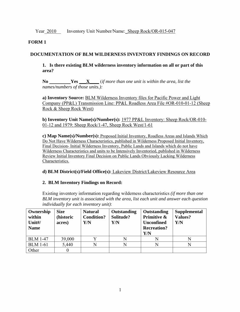
Year_2010__ Inventory Unit Number/Name:_Sheep Rock/OR-015-047 FORM 1 DOCUMENTATION OF BLM WILDERNESS INVENTORY FINDINGS ON RECORD 1. Is there existing BLM wilderness inventory information on all or part of this area? No Yes ___X____ (if more than one unit is within the area, list the names/numbers of those units.): a) Inventory Source: BLM Wilderness Inventory files for Pacific Power and Light Company (PP&L) Transmission Line: PP&L Roadless Area File #OR-010-01-12 (Sheep Rock & Sheep Rock West) b) Inventory Unit Name(s)/Number(s): 1977 PP&L Inventory: Sheep Rock/OR-010- 01-12 and 1979: Sheep Rock/1-47, Sheep Rock West/1-61 c) Map Name(s)/Number(s): Proposed Initial Inventory, Roadless Areas and Islands Which Do Not Have Wilderness Characteristics, published in Wilderness Proposed Initial Inventory, Final Decision- Initial Wilderness Inventory, Public Lands and Islands which do not have Wilderness Characteristics and units to be Intensively Inventoried, published in Wilderness Review Initial Inventory Final Decision on Public Lands Obviously Lacking Wilderness Characteristics. d) BLM District(s)/Field Office(s): Lakeview District/Lakeview Resource Area 2. BLM Inventory Findings on Record: Existing inventory information regarding wilderness characteristics (if more than one BLM inventory unit is associated with the area, list each unit and answer each question individually for each inventory unit): Ownership Size Natural Outstanding Outstanding Supplemental within (historic Condition? Solitude? Primitive & Values? Unit#/ acres) Y/N Y/N Unconfined Y/N Name Recreation? Y/N BLM 1-47 39,000 Y N N N BLM 1-61 5,440 N N N N Other 0 1
Transcript
Year_2010__ Inventory Unit Number/Name:_Sheep Rock/OR-015-047
FORM 1
DOCUMENTATION OF BLM WILDERNESS INVENTORY FINDINGS ON RECORD
1. Is there existing BLM wilderness inventory information on all or part of this area?
No Yes ___X____ (if more than one unit is within the area, list the names/numbers of those units.):
a) Inventory Source: BLM Wilderness Inventory files for Pacific Power and Light Company (PP&L) Transmission Line: PP&L Roadless Area File #OR-010-01-12 (Sheep Rock & Sheep Rock West)
b) Inventory Unit Name(s)/Number(s): 1977 PP&L Inventory: Sheep Rock/OR-010-01-12 and 1979: Sheep Rock/1-47, Sheep Rock West/1-61
c) Map Name(s)/Number(s): Proposed Initial Inventory, Roadless Areas and Islands Which Do Not Have Wilderness Characteristics, published in Wilderness Proposed Initial Inventory, Final Decision- Initial Wilderness Inventory, Public Lands and Islands which do not have Wilderness Characteristics and units to be Intensively Inventoried, published in Wilderness Review Initial Inventory Final Decision on Public Lands Obviously Lacking Wilderness Characteristics.
d) BLM District(s)/Field Office(s): Lakeview District/Lakeview Resource Area
2. BLM Inventory Findings on Record:
Existing inventory information regarding wilderness characteristics (if more than one BLM inventory unit is associated with the area, list each unit and answer each question individually for each inventory unit):
Y/N BLM 1-47 39,000 Y N N N BLM 1-61 5,440 N N N N Other 0
1
FORM 2
DOCUMENTATION OF CURRENT WILDERNESS INVENTORY CONDITIONS
a. Unit Number/Name: Sheep Rock/OR-015-047
(1) Is the unit of sufficient size? Yes X No
Citizen Information Received: In 2005, the BLM received a citizen proposal from the Oregon Natural Desert Association (ONDA) for the 90,312-acre Burma Rim proposed Wilderness Study Area (WSA). ONDA included in their information a narrative report, maps, photos, photo and route logs, and GIS data with their route and photo point data. All of these materials were considered during the BLM’s wilderness inventory process for this area. The photos submitted by ONDA were taken in July of 2004 and June of 2005. They identified the area as having no interior routes which met the BLM wilderness inventory definition of a road (see Map 2A, p. 29 of ONDA 2005).
Boundary Determination and Consideration of Citizen Information: In the summer of 2008, 2009, and 2010, members of the BLM staff conducted a field inventory of the area to update its road and wilderness inventory for this area and to gather additional information to supplement ONDA’s wilderness information. This field work included photo documentation of the boundary and interior routes and a re-evaluation of wilderness characteristics for this area. Using both ONDA and BLM photos, field logs, and staff field knowledge, a BLM inter-disciplinary (ID) team completed road analyses on the main routes within the area.
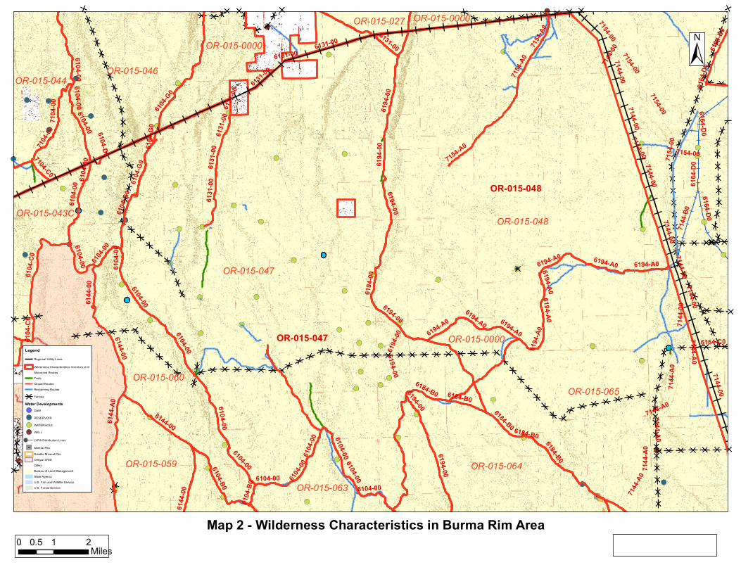
The results of the road analysis are documented in the road analysis forms contained in the wilderness evaluation file. The BLM ID team determined that several of the routes ONDA identified as “ways” are in fact boundary roads. For this reason, the BLM found the Burma Rim proposed WSA is not one large roadless unit, but is comprised of several smaller inventory units (Maps 1 and 2A) which must be evaluated individually.
Since 1977, the boundaries for these units have changed. The northern boundary is now a PP&L transmission line right-of-way running east to west across the north side of the unit that was constructed in the in 1980’s and private land boundaries. The road which historically separated units 1-47 (Sheep Rock) and 1-61(Sheep Rock West) no longer meets the definition of a boundary road; therefore these two units were combined for this analysis. The remaining boundaries are similar to those used in the 1977 inventory. The eastern boundary consists of the 6194-00 Burma road. The southern boundary consists of the 6194-A0 road, an unnumbered connector between the 6194-A0 and the 6184-B0, the 6184-B0, and the 6194-00. The 6104-00 Sheep Rock Road forms the remainder of the southern boundary and the whole of the western boundary (Map2A) The Sheep Rock unit is currently 48,999 acres in size. (Refer to the road analysis forms, photos, photo logs, and BLM ID team minutes in the wilderness inventory file for additional supporting information regarding these boundary determinations).
2
Following the boundary determinations, the BLM ID team subsequently evaluated the wilderness characteristics within the Sheep Rock OR-015-047 unit. The results are contained in the following sections. Additional background on the process that the BLM ID team followed during this evaluation is contained in the document, Wilderness Inventory Maintenance Process for the Lakeview Resource Area, BLM contained in the wilderness inventory file.
DESCRIPTION OF CURRENT CONDITIONS: The unit contains a series of north to south running basalt rims with angled plateaus between them sloping down to the next playa basin and rim. Burma Rim runs along the east boundary with Sheep Rock at the south end of the unit. There are no permanent springs or streams, but several playa lake bed waterholes. The vegetative cover is primarily desert sagebrush and grassland.
(2) Is the unit in a natural condition? Yes X No ______ N/A_______
Previous Inventory Description: The human imprints recorded during the original 1977 inventory included visual impacts from transportation, and grazing management. There were three roads extending into the area, two from the north and one from the south. Managed stock water ponds were also present. These disturbances were considered minor and the BLM concluded the area was natural.
Current Description: ONDA’s 2005 inventory concluded that the proposed 90,000 acre Burma Rim unit was generally natural and affected primarily by the forces of nature. After an intensive review, the BLM determined that ONDA's proposed Burma Rim unit is not one large roadless area, but is comprised of several smaller inventory units.
The most notable change in the Sheep Rock Unit's landscape is the high voltage transmission line and right of way which now forms the northern boundary of the unit. The power line itself is a visual intrusion on the north side of the unit. Human imprints include impacts from the three private land in holdings, two totaling 645 acres along the northern boundary, and one 160 acre in holding along the eastern boundary.
There are approximately 44 miles of primitive routes, and motorized trails in the unit including two cherry-stem boundary roads which allow motorized access for recreation and grazing activities (Map2A). The cherry stemmed roads are technically outside of the inventory unit but are still substantially noticeable from portions of the interior of the unit.
The vegetative cover of the unit has not changed significantly since 1977. This shrub-steppe biotic community includes sagebrush, grass, and low growing perennials.
There are 28 water developments in the unit (one reservoir and 27 waterholes), along with 15.3 miles of pasture division fence (Map2A).
3
One can gain a general overview of the naturalness of this unit by examining both ONDA and BLM field photographs contained in the wilderness inventory file. After considering the human imprints described above, the BLM ID team concluded that most of this unit would appear to be natural to the casual observer. The range and wildlife developments are substantially noticeable from close distance (1/4mile), but are less noticeable from further distances. The transmission line has the most impact on the naturalness of the area; however, they are not visible from the entire unit and overall, the unit is natural.
(3) Does the unit have outstanding opportunities for solitude? Yes No X N/A________
Previous Inventory Description: In 1977 the unit was evaluated as having opportunities for solitude due to a feeling of spaciousness, with topography, size, or shape of the area providing isolation. However, the airspace above half of the unit was noted as part of the Juniper low-altitude military operation area (MOA). The noise from aircraft training was found to be a potential intrusion in the area when training occurs.
Current Description: ONDA’s 2005 inventory concluded that the proposed 90,000 acre Burma Rim unit would easily allow visitors to experience solitude. Upon review, the BLM found that the proposed unit was not one large roadless area, but several smaller inventory units, each one of which needs to be evaluated separately for outstanding opportunities for solitude.
Within the Sheep Rock unit, the high voltage transmission line was completed across the northern boundary since the original inventory. The power line towers and transmission lines are visible throughout the northern half of the unit. Additionally, access roads were built during power line construction and these roads are visible and used by power company employees on a regular basis for access and maintenance. There is also an audible impact from these lines and this impact increases as one is closer to the towers.
The areas topography has not changed since 1977. The majority of this unit has some topographic, but limited tall vegetative screening to provide opportunities for solitude (Map3). The unit is roughly divided into thirds by two prominent north-south running rims. While it may be possible for individuals to find some solitude at distant points within the unit, the limited screening of the surrounding area limits the overall feeling of solitude.
This area lies beneath airspace that is used by the military for low altitude tactical training and is known as the Juniper Low Altitude Military Operation Area (MOA). The MOA was established in the mid-1990’s and is outside BLM’s regulatory or management authority. Jet fighters frequently fly much of the Sheep Rock unit at very low altitude causing noticeable and/or loud noise intrusions into the surrounding area. Though this factor is an “outside sight or sound” that, in and of itself, does not preclude the area from meeting the solitude criteria, the aircraft adversely impact the opportunity for solitude in the area on a frequent basis.
4
The ID team determined that this unit currently does not provide outstanding opportunities for solitude because of the impacts from the transmission line and associated maintenance activities; the private lands and associated motorized access, sound intrusions from military training, and the limited vegetative screening. See photo-documentation for more detail.
(4) Does the unit have outstanding opportunities for primitive and unconfined recreation? Yes No X N/A________
Previous Inventory Description: The 1977 inventory listed hunting, backpacking, hiking, horseback riding, dry camping and rock climbing as possible recreation activities within the unit. The evaluation also listed marginal antelope hunting and the unit as having a scenic quality of “medium”. The BLM concluded that the area did not offer outstanding primitive or unconfined recreational opportunities.
Current Description: ONDA’s 2005 inventory concluded that their proposed 90,000 acre Burma Rim unit would allow users outstanding opportunities for primitive and unconfined recreation due to the unit's topography. After further review, the BLM found the proposed unit was not one large roadless area, but was in fact made up of several smaller inventory units which must be evaluated individually.
Recreation opportunities in the Sheep Rock unit have not undergone many changes since the 1977 inventory. The BLM ID Team identified hunting, backpacking, hiking, horseback riding, and camping as continuing possible recreation activities within the unit.
The Lakeview RMP/ROD (Map 7) shows that this area is open to off-highway vehicle use. This designation allows or promotes motorized vehicle use both on and off existing routes. There are a number of existing internal primitive motorized routes, trails, and cherry-stemmed roads (Map 2A) that provide motorized access to large portions of the interior of the unit. This further limits the ability to have a primitive recreational experience because of the motorized activity in the unit. The noise level associated with motorized activity also diminishes the quality of the recreational experience for those visitors looking for a primitive backcountry experience.
The unit does not currently provide outstanding primitive recreational opportunities or an outstanding diversity of primitive recreation opportunities. The recreation opportunities are similar to those provided by the BLM lands surrounding the area. For these reasons the BLM team concluded this area does not contain outstanding opportunities for primitive and unconfined recreation.
(5) Does the unit have supplemental values? Yes No N/A__X____
Description: Supplemental values were not evaluated as the unit does not meet the minimum wilderness criteria.
5
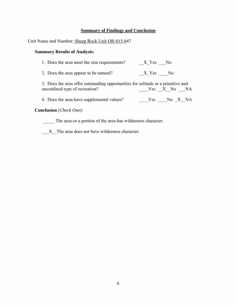
Summary of Findings and Conclusion Unit Name and Number: Sheep Rock Unit OR-015-047
Summary Results of Analysis: 1. Does the area meet the size requirements? __X_Yes ___No
2. Does the area appear to be natural? __X_Yes ____No 3. Does the area offer outstanding opportunities for solitude or a primitive and unconfined type of recreation? ____Yes __X__No ___NA 4. Does the area have supplemental values? ____Yes ____No _X__NA Conclusion (Check One):
_____ The area-or a portion of the area-has wilderness character. ___X__The area does not have wilderness character.
6
Prepared by (ID Team Member Names and Titles):
Paul Whitman Planning & Environmental Coordinator
Chris
~dForbes · 1<\sststant Fteld Manager
e Casey~ Range Management Specialist
Ed Hennagin Cartographic Technician
Cartographic Technician
Approved by:
c.Lc~ Thomas R. Rasmussen Field Manager
.J I/17 );;oto Date 1
Date
This form documents information that constitutes an inventory finding on wilderness characteristics. It does not represent a formal/and use allocation or a final agency decision subject to administrative remedies under either 43 CFRparts 4 or 1610.5-2.
7
Year_2010 Inventory Unit Number/Name: ____Burma/OR-015-048_______
FORM 1
DOCUMENTATION OF BLM WILDERNESS INVENTORY FINDINGS ON RECORD
1. Is there existing BLM wilderness inventory information on all or part of this area?
No Yes ___X____ (if more than one unit is within the area, list the names/numbers of those units.):
a) Inventory Source: BLM Wilderness Inventory files for Pacific Power and Light Company (PP&L) Transmission Line: PP&L Roadless Area File #OR-010-01-8 (Burma)
b) Inventory Unit Name(s)/Number(s):1977 PP&L Inventory: Burma/OR-010-01-8 and 1977: Burma/1-48___
c) Map Name(s)/Number(s): Proposed Initial Inventory, Roadless Areas and Islands Which Do Not Have Wilderness Characteristics, published in Wilderness Proposed Initial Inventory, Final Decision- Initial Wilderness Inventory, Public Lands and Islands which do not have Wilderness Characteristics and units to be Intensively Inventoried, published in Wilderness Review Initial Inventory Final Decision on Public Lands Obviously Lacking Wilderness Characteristics.
d) BLM District(s)/Field Office(s):_Lakeview District, Lakeview Resource Area
2. BLM Inventory Findings on Record:
Existing inventory information regarding wilderness characteristics (if more than one BLM inventory unit is associated with the area, list each unit and answer each question individually for each inventory unit):
DOCUMENTATION OF CURRENT WILDERNESS INVENTORY CONDITIONS
a. Unit Number/Name:___Burma/OR-015-048____
(1) Is the unit of sufficient size? Yes __X__ No
Citizen Information Received: In 2005, the BLM received a citizen proposal from the Oregon Natural Desert Association (ONDA) for the 90,312-acre Burma Rim proposed Wilderness Study Area (WSA). ONDA included in their information a narrative report, maps, photos, photo and route logs, and GIS data with their route and photo point data; All of these materials were considered during the BLM’s wilderness inventory process for this area. The photos submitted by ONDA were taken in July of 2004 and June of 2005. They identified the area as having no interior routes which met the BLM wilderness inventory definition of a road (see Map 1, p. 29 of ONDA 2005).
Boundary Determination and Consideration of Citizen Information: In the summer of 2008, 2009, and 2010, members of the BLM staff conducted a field inventory of the area to update its road and wilderness inventory for this area and to gather additional information to supplement ONDA’s wilderness information. This field work included photo documentation of the boundary and interior routes and a re-evaluation of wilderness characteristics for this area. Using both ONDA and BLM photos, field logs, and staff field knowledge, a BLM inter-disciplinary (ID) team completed road analyses on the main routes within the area.
The results of the road analysis are documented in the road analysis forms contained in the wilderness evaluation file. The BLM ID team determined that several of the routes ONDA identified as “ways” are in fact boundary roads. For this reason, the BLM found the Burma Rim proposed WSA is not one large roadless unit, but is comprised of several smaller inventory units (Maps 1 and 2B) which must be evaluated individually.
Since 1977, the boundaries of the Burma unit have changed. The northern boundary is now a PP&L transmission line right-of-way running east to west across the north side of the unit that was constructed in the 1980’s. The remaining boundaries are very similar to the previously inventoried unit’s boundaries. To the east is a Bonneville Power Administration transmission line right-of-way. To the south is the 6194-A0 road forming the entire southern boundary and the western boundary is made up of the 6194-00 Road (Map2B). The Burma unit is currently 36,682 acres in size. (Refer to the road analysis forms, photos, photo logs, and BLM ID team minutes in the wilderness inventory file for additional supporting information regarding these boundary determinations).
Following the boundary determination, the BLM ID team subsequently evaluated the wilderness characteristics within the Burma unit. The results are contained in the following sections. Additional background on the process that the BLM ID team followed during this evaluation is contained in the document, Wilderness Inventory
2
Maintenance Process for the Lakeview Resource Area, BLM contained in the wilderness inventory file.
DESCRIPTION OF CURRENT CONDITIONS: The unit is mostly flat with a gently sloping surface. The western edge of the unit contains the large west facing Burma rim. A large shallow basin makes up the center, and several small basins are located along the edges. There are no permanent springs or streams, but there are several playa lakebed waterholes. Vegetative cover is primarily desert sagebrush and grassland.
(2) Is the unit in a natural condition? Yes __X No ______ N/A_______
Previous Inventory Description: The 1977 inventory listed man made intrusions as transportation, utility and, grazing management related, medium in scale, but few in number. The unit was described as having stock water ponds and, roads extending into it from the north and south. Two airplane wrecks in the southwest and a power line along it's east boundary. These disturbances were considered minor and the BLM concluded the area was natural.
Current Description: ONDA’s 2005 inventory concluded that their proposed 90,000 acre Burma Rim unit was generally natural and affected primarily by the forces of nature. After intensive review the BLM determined that the proposed Burma Rim unit is not one large roadless area, but is comprised of several smaller inventory units, which must be evaluated individually.
The most notable change in the Burma unit's landscape would be the high-voltage transmission line and right of way which now forms the northern boundary of the unit. The power line itself is a visual intrusion on the north side of the unit. The BPA power line continues to intrude visually into the eastern half of the unit.
There are approximately 11 miles of primitive routes, and motorized trails in the unit which allow motorized access by for recreation and grazing activities. There is also a cherry-stem boundary road of 7154-A0 beginning near the northeast corner of the unit and extending into the middle of the unit. The cherry-stem road is technically outside of the inventory unit, but is still substantially noticeable from portions of the interior of the unit (Map2B).
The vegetative cover of the unit has not changed significantly since 1977. This shrub-steppe biotic community includes sagebrush, grass, and low growing perennials. There is a record of a 1984, 852 acre wildfire in the northern end of the unit (Map2B).
There are nine water developments (five waterholes and four water troughs) in the unit. Some of these water developments are associated with 2.5 miles of pipeline in the southeast corner and along the 7154-A0 road, which was installed in the last ten years (Map2B).
3
The two historic military airplane wrecks are still present along the western edge of the unit. A horse trap is located near Fire Lake on the southern boundary and has an accompanying access route.
One can gain a general overview of the naturalness of this unit by examining both ONDA and BLM field photographs contained in the wilderness inventory file. After considering the human imprints described above, the BLM ID team concluded that most of this unit would appear to be natural to the casual observer. The range and wildlife developments are noticeable from close distance (1/4mile), but are less noticeable from further distances. The transmission lines have the most impact on the naturalness of the area; however the team agreed that a majority of the disturbances are located around the perimeter of the unit. For these reasons the team concluded that the natural character of the area has not changed substantially since 1977 and the unit appears largely natural.
(3) Does the unit have outstanding opportunities for solitude? Yes No N N/A________
Previous Inventory Description: The 1977 inventory listed, utilities, and the Juniper low-altitude MOA as the predominate man-made intrusions on a medium scale but few in the unit. Due to the fairly open landscape the man-made intrusions were prevalent from most points and users were likely to be aware of others in the unit. For these reasons, solitude opportunities were not outstanding.
Current Description: ONDA’s 2005 inventory concluded that their proposed 90,000 acre Burma Rim unit would easily allow visitors to experience solitude. Upon review, the BLM found that the proposed unit was not one large roadless area, but several units, each one of which needs to be evaluated separately for outstanding opportunities for solitude.
PP&L constructed a high-voltage transmission line was completed across the northern boundary of the area since the original inventory. The power line towers and transmission lines are visible throughout the northern half of the unit. Additionally, access roads were built during construction and these roads are visible and used by power company employees on a regular basis for access and maintenance. There is also an audible impact from these lines and this impact increases as one is closer to the towers. These same impacts can be noticed for the BPA power line which forms the eastern boundary.
The topography in the Burma unit has not changed since 1977. The majority of this unit has limited topographic and vegetative screening to provide opportunities for solitude. The landscape is dominated by big open views where it is difficult to avoid the presence of others in the unit (Map3). The unit is still within the Juniper Military Operations area for low flying aircraft is negatively affected by noise intrusions when aircraft are training in the area.
The ID team determined that even though the unit is fairly large, there is a lack of screening throughout; therefore, few or limited opportunities for solitude exist. For these
4
reasons, the team concluded that the opportunities for solitude have not changed substantially since 1979. There are no outstanding opportunities for solitude in this unit.
(4) Does the unit have outstanding opportunities for primitive and unconfined recreation? Yes No X N/A________
Previous Inventory Description: The 1977 inventory listed hunting, backpacking, hiking, horseback riding, dry camping, and zoological resources as opportunities for primitive recreation within the unit. It was described as having marginal antelope hunting, wild horse viewing and a low scenic quality.
Current Description: ONDA’s 2005 inventory concluded that their proposed 90,000 acre Burma Rim unit would allow users outstanding opportunities for primitive and unconfined recreation due to the units’ topography. After further review, the BLM found their proposed unit was not one large roadless area , but was in fact made up of several smaller inventory units which must be evaluated individually.
Recreation opportunities in the Burma unit have not undergone many changes since the 1977 evaluation. The BLM ID Team identified hunting, backpacking, hiking, horseback riding, and camping as continuing possible recreation activities within the unit.
The Lakeview RMP/ROD (Map 7) shows that this area is open to off-highway vehicle use. This designation allows or promotes motorized vehicle use both on and off existing routes. There are a number of existing internal primitive motorized routes, trails, and a cherry-stemmed road (Map 2B) which provides motorized access to portions of the interior of the unit. This further limits the ability to have a primitive recreational experience because of the motorized activity in the unit. The noise level associated with motorized activity also diminishes the quality of the recreational experience for those visitors looking for a primitive backcountry experience.
The two historic military airplane wreck sites now have small interpretive plaques for visitors. Overall the primitive recreation opportunities are typical of the surrounding BLM lands and are not outstanding; the only two unique opportunities are the two plane crash sites.
For these reasons the BLM team concluded this area does not contain outstanding opportunities for primitive and unconfined recreation.
(5) Does the unit have supplemental values? Yes No N/A___X___
Description: Supplemental values were not evaluated as the unit does not meet the minimum wilderness criteria.
5
Summary of Findings and Conclusion Unit Name and Number:___Burma/OR-015-48___
Summary Results of Analysis: 1. Does the area meet the size requirements? __X__Yes ___No 2. Does the area appear to be natural? __X_Yes ____No 3. Does the area offer outstanding opportunities for solitude or a primitive and unconfined type of recreation? ____Yes __X__No ___NA 4. Does the area have supplemental values? ___Yes ____No _X__NA Conclusion (Check One):
_____ The area-or a portion of the area-has wilderness character. ___X__The area does not have wilderness character.
6
Prepared by (ID Team Member Names and Titles):
Paul Whitman . Planning & Environmental Coordinator
~tY~ Range Management Specialist
Ed Hennagin Cartographic Technician
Zach a Cartog p 1c Techn n
Approved by:
Thomas R. Rasmussen Field Manager
·-
11 ) n/ ;;ot o Date'
/-2J1:> Date
This form documents information that constitutes an inventory finding on wilderness characteristics. It does not represent a formal/and use allocation or a final agency decision subject to administrative remedies under either 43 CFRparts 4 or 1610.5-2.
7
Year_2010_ Inventory Unit Number/Name: Burma Rim Area Sm all/Unnumbered Units
FORM 1
DOCUMENTATION OF BLM WILDERNESS INVENTORY FINDINGS ON RECORD
1. Is there existing BLM wilderness inventory information on all or part of this area?
No Yes ___X____ (if more than one unit is within the area, list the names/numbers of those units.):
a) Inventory Source: BLM Wilderness Inventory files for Pacific Power and Light Company (PP&L) Transmission Line: PP&L Roadless Area File #OR-010-01-12 (Sheep Rock & Sheep Rock West), #OR-010-01-8 (Burma), #OR-010-04-15 (Fandango)
b) Inventory Unit Name(s)/Number(s): Sheep Rock/1-47, Sheep Rock West/1-61, Burma/1-48, Fandango/1-46
c) Map Name(s)/Number(s): Proposed Initial Inventory, Roadless Areas and Islands Which Do Not Have Wilderness Characteristics, published in Wilderness Proposed Initial Inventory, Final Decision- Initial Wilderness Inventory, Public Lands and Islands which do not have Wilderness Characteristics and units to be Intensively Inventoried, published in Wilderness Review Initial Inventory Final Decision on Public Lands Obviously Lacking Wilderness Characteristics.
d) BLM District(s)/Field Office(s):_Lakeview District, Lakeview Resource Area 2. BLM Inventory Findings on Record:
Existing inventory information regarding wilderness characteristics (if more than one BLM inventory unit is associated with the area, list each unit and answer each question individually for each inventory unit):
DOCUMENTATION OF CURRENT WILDERNESS INVENTORY CONDITIONS
a. Unit Number/Name Burma Rim Area Small/Unnumbered Units (1) Is the unit of sufficient size? Yes No X
Citizen Information Received: In 2005, the BLM received a citizen proposal from the Oregon Natural Desert Association (ONDA) for the 90,312-acre Burma Rim proposed Wilderness Study Area (WSA). ONDA included in their information a narrative report, maps, photos, photo and route logs, and GIS data with their route and photo point data. All of these materials were considered during the BLM’s wilderness inventory process for this area. The photos submitted by ONDA were taken in July of 2004 and June of 2005. They identified the area as having no interior routes which met the BLM wilderness inventory definition of a road (see Map 2C, p. 29 of ONDA 2005). Boundary Determination and Consideration of Citizen Information: In the summer of 2008, 2009, and 2010, members of the BLM staff conducted a field inventory of the area to update its road and wilderness inventory for this area and to gather additional information to supplement ONDA’s wilderness information. This field work included photo documentation of the boundary and interior routes and a re-evaluation of wilderness characteristics for this area. Using both ONDA and BLM photos, field logs, and staff field knowledge, a BLM inter-disciplinary (ID) team completed road analyses on the main routes within the area. The results of the road analysis are documented in the road analysis forms contained in the wilderness evaluation file. The BLM ID team determined that several of the routes ONDA identified as “ways” are in fact boundary roads. For this reason, the BLM found the Burma Rim proposed WSA is not one large roadless unit, but is comprised of several smaller inventory units (Maps 1 and 2C) which must be evaluated individually. Of these units, three did not meet the minimum size requirement of 5000 acres. These units are bounded by the PP&L power line right-of-way, BLM Roads 6104-00, 6104-G0, 6184-B0, 6194-A0, and two unnumbered roads. Based on this determination there was no need for the BLM ID team to evaluate these units further. Additional background on the process that the BLM ID team followed during this evaluation is contained in the document Wilderness Inventory Maintenance Process for the Lakeview Resource Area, BLM contained in the wilderness inventory file. (2) Is the unit in a natural condition? Yes No ______ N/A___X____
Description: Naturalness was not evaluated as the units did not meet the minimum wilderness criteria.
2
(3) Does the unit have outstanding opportunities for solitude? Yes No N/A____X____
Description: Solitude was not evaluated as the units did not meet the minimum wilderness criteria.
(4) Does the unit have outstanding opportunities for primitive and unconfined recreation? Yes No N/A____X____ Description: Recreation was not evaluated as the units did not meet the minimum wilderness criteria.
(5) Does the unit have supplemental values? Yes No N/A___X___ Description: Supplemental values were not evaluated as the units did not meet the minimum wilderness criteria.
3
Summary of Findings and Conclusion Unit Name and Number: Burma Rim Small Units
Summary Results of Analysis: 1. Does the area meet the size requirements? ___Yes _X_No 2. Does the area appear to be natural? ___Yes ____No _X_ NA 3. Does the area offer outstanding opportunities for solitude or a primitive and unconfined type of recreation? ____Yes ____No _X__NA 4. Does the area have supplemental values? ___Yes ____No _X__NA Conclusion (Check One):
_____ The area-or a portion of the area-has wilderness character. ___X__The area does not have wilderness character.
4
Prepared by (ID Team Member Names and Titles):
Paul Whitman Planning & Environmental Coordinator
Chris Outdo
Casey O'Connor Range Management Specialist
Zach Adams' Cartograph4 Technic!
Approved by:
Thomas R. Rasmussen Field Manager
t;fo/Jc Date
This form documents information that constitutes an inventory finding on wilderness characteristics. It does not represent a formal/and use allocation or a final agency decision subject to administrative remedies under either 43 CFRparts 4 or 1610.5-2.
5
Adel
Plush
Paisley
Lakeview
Fort Rock
Summer Lake
Silver Lake
Valley Falls
New Pine Creek
Christmas Valley
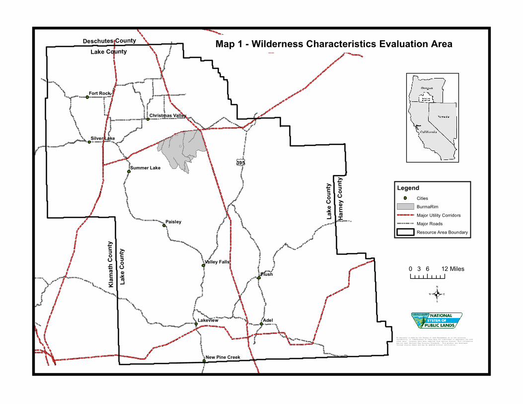
Map 1 - Wilderness Characteristics Evaluation Area
Lake
Cou
ntyKl
amath
Cou
nty
Lake County
Lake
Cou
ntyHa
rney
Cou
nty
Deschutes County
.
LegendCitiesBurmaRimMajor Utility CorridorsMajor RoadsResource Area Boundary
No warranty is made by the Bureau of Land Management as to the accuracy, reliability, or completeness of these data for individual or aggregate use with other data. Original data were compiled from various sources. This information may not meet National Map Accuracy Standards. This product was developed through digital means and may be updated without notification .