Page 1
FULLY AUTOMATED REGISTRATION OF 3D CAD MODEL WITH POINT CLOUD FROM CONSTRUCTION SITE
Changmin Kim, Joohyuk Lee, Minwoo Cho, and Changwan Kim*
Department of Architectural Engineering, Chung-Ang University, Seoul, Korea
* Corresponding author ([email protected] )
ABSTRACT: In construction automation applications, registration between the 3D computer-aided design (CAD) model
and the point cloud obtained by remote sensing technology is an important process such as progress monitoring and as-built
modeling. However, the registration method to align the 3D CAD model and point cloud in construction automation has
limitations because the registration is performed manually, which is less accurate and more time-consuming. In this paper,
an automated registration method for a 3D CAD model with point cloud from the construction site is proposed.
Preprocessing is presented to convert points into suitable representation for registration. Then, an automated registration
method that determines transformation parameters is presented. Field experiments have been conducted to test the proposed
registration method and the results show that the proposed method is useful for construction automation.
Keywords: Iterative Closest Point, Principle Component Analysis, 3D Registration
1. INTRODUCTION
Registration is a process by which the data acquired from
different conditions such as time, viewpoint, sensors and
source are transformed and aligned with the same
coordinate system [1, 2]. Registration is a fundamental to
perform various applications in computer vision such as
change detection, object recognition, industrial automation
and inspection [3, 4]. In construction automation,
registration of the 3D computer-aided design (CAD) model
with the point cloud obtained from the construction site is
an important process for applications such as progress
monitoring and as-built modeling [5, 6, 7]. To perform
progress monitoring, the 3D CAD model which contains
schedule information, needs to be aligned with the point
cloud, which is obtained from structural components, for
comparing two data sets. In as-built modeling, the 3D CAD
models must be registered with a 3D as-built point cloud to
match and retrieve 3D CAD components.
Although registration is useful in construction automation,
the current registration of the 3D CAD model with the
point cloud method is inefficient. Registration in
construction automation is customarily performed
manually which can provide inaccurate results due to
human error and users’ subjective interpretations. The
process is also time-consuming because the point cloud
acquired from the construction site is large. These
problems limit the usage of point cloud that is obtained
from the construction site.
To minimize manual intervention during the registration
process, [6] proposed a semi-automated registration
method for aligning 3D CAD model and point cloud
obtained from steel structures. In this research, n-point
registration where the user manually selects more than
three pairs of corresponding points in the 3D CAD model
and point cloud, was used. The iterative closest point
algorithm was then used to refine the results of the n-point
registration. However, the n-point registration forces the
user to select several control points to obtain reliable
results, which can be tedious and labor-intensive [8].
In this paper, an automated registration method of a 3D
CAD model with point cloud obtained from the
construction site is proposed. Proposed registration method
explained in detail in the “Research Methodology” section.
Using the proposed method, field experiments have been
conducted using 3D CAD model and photogrammetric data
obtained from the construction site.
S26-7
917
Page 2
2. RESEARCH METHODOLOGY
The registration process of the 3D CAD model and point
cloud is composed of three steps. The first step is
preprocessing, which converts points into a suitable
representation for 3D registration. Then, the 3D
registration estimates the transformation parameters to
align model points and data points. The 3D registration can
be divided into coarse and fine registration. A detailed
description of the methodology is as follows.
2.1. Preprocssing
The 3D CAD model and point cloud that are obtained by
remote sensing technology is represented by each format.
To perform registration, the 3D CAD model and point
cloud must be converted into the suitable representation.
The 3D CAD model itself is exported in a
stereolithography (STL) format consisting of normal and
triangular facets. Uniform resolution model points are then
generated based on the triangular facets. However, point
cloud obtained by remote sensing technology, such as laser
scanner or photogrammetry technology, is represented by
multiresolution point cloud, because the resolution of point
cloud is dependent on the distance between the object and
sensor. It is difficult to obtain accurate registration results
when two data sets have different resolutions [9]. To
remedy this, the model points and point cloud were
subjected to a data re-sampling process in order to improve
registration accuracy.
In this research, an octree representation was used to make
regular points for data re-sampling. An octree is a tree-
structure that can be used to represent volumetric data
surrounded by a bounding cube. The initial cube that is
created using the boundary of the object is subdivided into
eight sub-cubes (octants), which are then repeatedly
subdivided several times, until each sub-cube contains no
points, or until the results reaches the criteria defined by
the application [10].
The re-sampling process is fourfold. First, each octree of
the original data is generated through repeated subdivision
as previously described. Second, a list of sub-cubes that
contain the points, central points, and the cube lengths is
generated. Sub-cubes that are larger than the criteria are
deleted from the list because they are unnecessary. Third,
all cubes with fewer points than the minimum requirement
are removed from the list. This is done to reduce noise,
which is an obstacle in robust registration. A cube will also
be removed if it contains no points. Finally, the central
points of all cubes are extracted, and the point cloud will
have a uniform resolution.
2.2. 3D Registration
In this research, registration of the model points with data
points consists of coarse and fine registration. In coarse
registration, principal component analysis (PCA) is used to
estimate the transformation parameter [11]. PCA provides a
rough estimate by using only three vectors as principal
components. Thus, to obtain the most accurate
transformation parameters, the iterative closest point (ICP)
was used as fine registration.
2.2.1. PCA Based Coarse Registration
PCA uses the direction of the principal axis of point cloud
to perform registration [12]. The direction of the principal
axis is defined as three eigenvectors of the covariance
matrix of the point sets [11]. The covariance matrix K for
given N points T , 1, … , is
defined as:
K 1
where the center of points T
∑ .
Let , ,
and
, , be eigenvectors and
eigenvalues of K, respectively . Then, K can
be factorized:
K Λ T
S26-7
918
Page 3
where , , and Λ diag λ , λ , λ .
The rotation matrix can be estimated from:
where and are eigenvectors of model points and
data points.
The translation vector can be estimated by calculating
the distance between the center of the model and the data
points.
where and are the center of the model points and
data points, respectively.
2.2.2. LM-ICP Based Fine Registration
The ICP algorithm proposed by [13] is widely used to
perform fine registration in two steps [14]. First, it
generates correspondence between two point sets such that
each set corresponds with the nearest point in the other
point set. Then, it computes the new transformation
parameters by minimizing the Euclidean distance between
corresponding point pairs. These two steps are iterated
until they converge at the user-defined criterion. This
algorithm is attractive because of its simplicity and
accuracy [15]. However, the original ICP algorithm
assumes outlier-free data and 100% overlap of the model
and data points [16]. These assumptions are not applicable
for construction applications because the point cloud
obtained from the construction site contains noise and only
partially corresponds with the 3D CAD model.
An algorithm that can improve these limitations is the
Levenberg-Marquardt iterative closest point (LM-ICP)
algorithm [15]. To generate the correct correspondence of
noisy data, LM-ICP serves as the threshold and weights are
introduced to deal with the issue of data points having no
correspondence with model points.
Below is the LM-ICP algorithm. Let be the
transformation parameter (rotation matrix and
translation vector ); then, the transformation can be
defined as:
;
The objective of the registration is to obtain transformation
parameters that minimize the distance between the data and
model points. Thus, the error function to be minimized is
defined as:
| ; |
where is the model points and refers to the data
points.
To reduce false correspondence caused by noise, the user
can define the threshold value which serves to make the
correspondence robust to noise. In addition, when dealing
with data points for which there is no correspondence with
the model points, weights are set to zero for points
with no match; otherwise, one is introduced. Thus, the
error function to be minimized is:
| ; |
To solve the least squares problem, the Levenberg-
Marquardt algorithm uses a gradient descent to minimize
the error function. It can be represented as follows:
δ JTe JTJ 0
where is the transformation parameter, δ is the
new estimated transformation parameter, and is the
Jacobian matrix with J .
The Levenberg-Marquardt algorithm updates δ
to reduce
error and can be used to determine the transformation
parameter through repetitive updates:
JT I JTe
S26-7
919
Page 4
where is
iteration and,
3. EXPERIM
Field experim
in order to es
registration m
building un
proposed me
and as-built
CAD model
illustrated in
cloud of the
system Photo
Inc., was ad
from 12 ima
using photorg
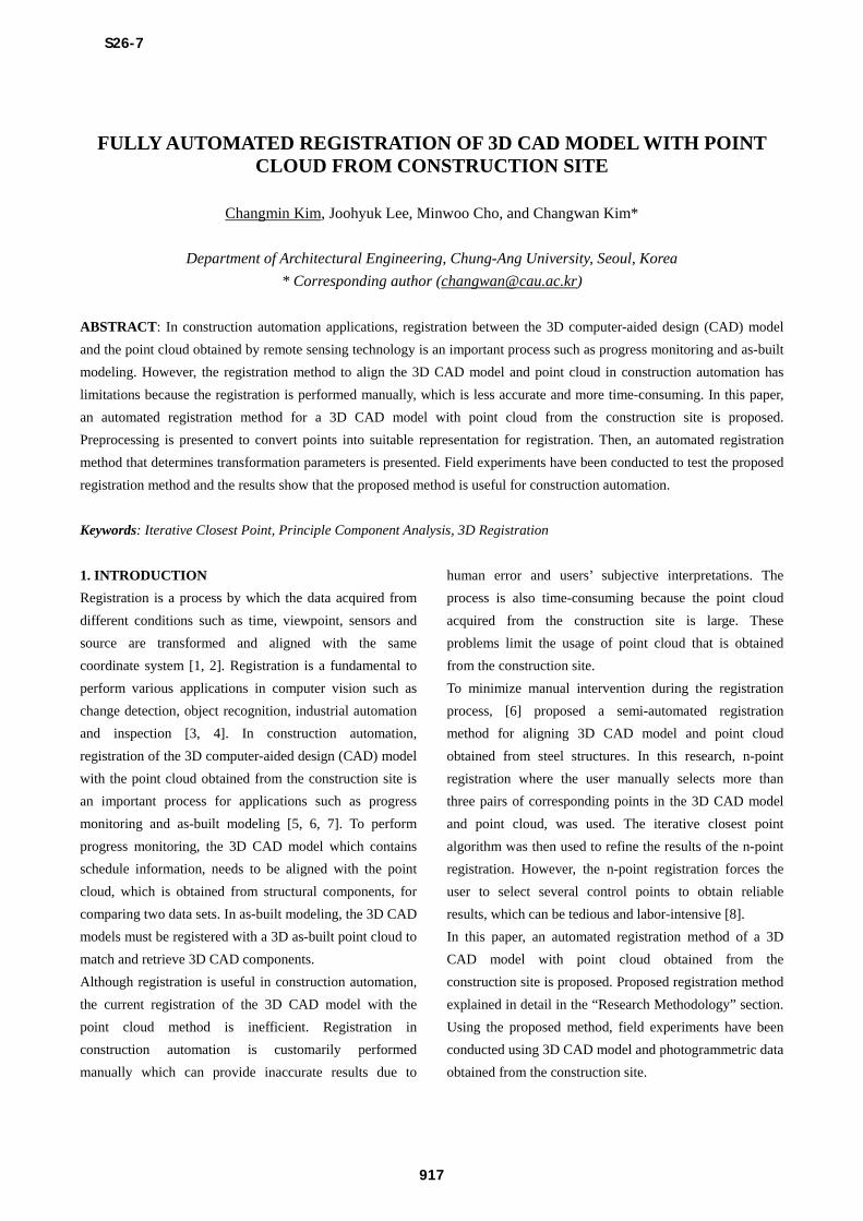
Fig. 1 Th
CAD model
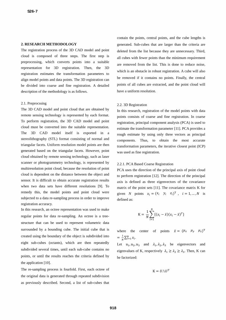
To perform r
to STL form
In data re-s
refined at the
data compo
respectively.
the resample
top views of
set to a star
, is an ident
MENTAL RE
ments were c
stablish the va
method. In th
nder construc
ethod’s appli
modeling. F
l for the ent
Fig. 1 (a). In
e structure, th
omodeler Scan
opted [17] an
ages. Point c
grammetry is
(a)
he test data se
(b) point clou
registration, th
at, then 125,9
sampling, bot
e same resolu
osed 22,522
Fig. 2 (a) an
ed model poin
the resampled
rt value and
tity matrix.
ESULTS
onducted at t
alidity of the p
he field expe
ction was ch
icability to p
From 2D CA
tire structure
n order to obta
he commercia
nner, develop
nd 921,782 po
cloud from th
illustrated in
ets used for e
ud from the co
he 3D CAD m
957 model poi
th model and
ution using oct
points an
nd (b) show f
nts, and (c) an
d data points.
is updated in
the constructio
proposed auto
eriments, a co
hosen to te
progress mon
AD drawings,
was generat
ain a complete
al photogram
ped by Eos Sy
oints were ob
he constructio
Fig. 1 (b).
(b)
experiments (
onstruction site
model was con
ints were gen
d data points
tree. The mod
nd 19,015 p
full and top vi
nd (d) show fu
n each
on site
omated
oncrete
st the
itoring
a 3D
ted, as
e point
mmetric
ystems,
btained
on site
(a) 3D
e
nverted
erated.
s were
del and
points,
ews of
ull and
Fi
re
m
(d
To
th
co
ro
tr
w
Fi
re
cr
m
re
Fi
vi
Fi
re
0.
60
pr
pr
fr
(a
(c
ig. 2 Resu
esampled mod
model points (
d) Top view of
o align the co
hat belong to e
onsists of coar
otation angle
ranslation vect
were obtained
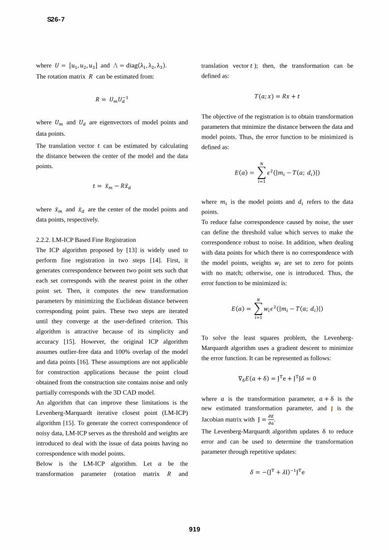
ig. 3 (a) an
egistration pro
reate difficul
monitoring or
equired to imp
(a
ig. 3 Resu
iew (b) Top vi
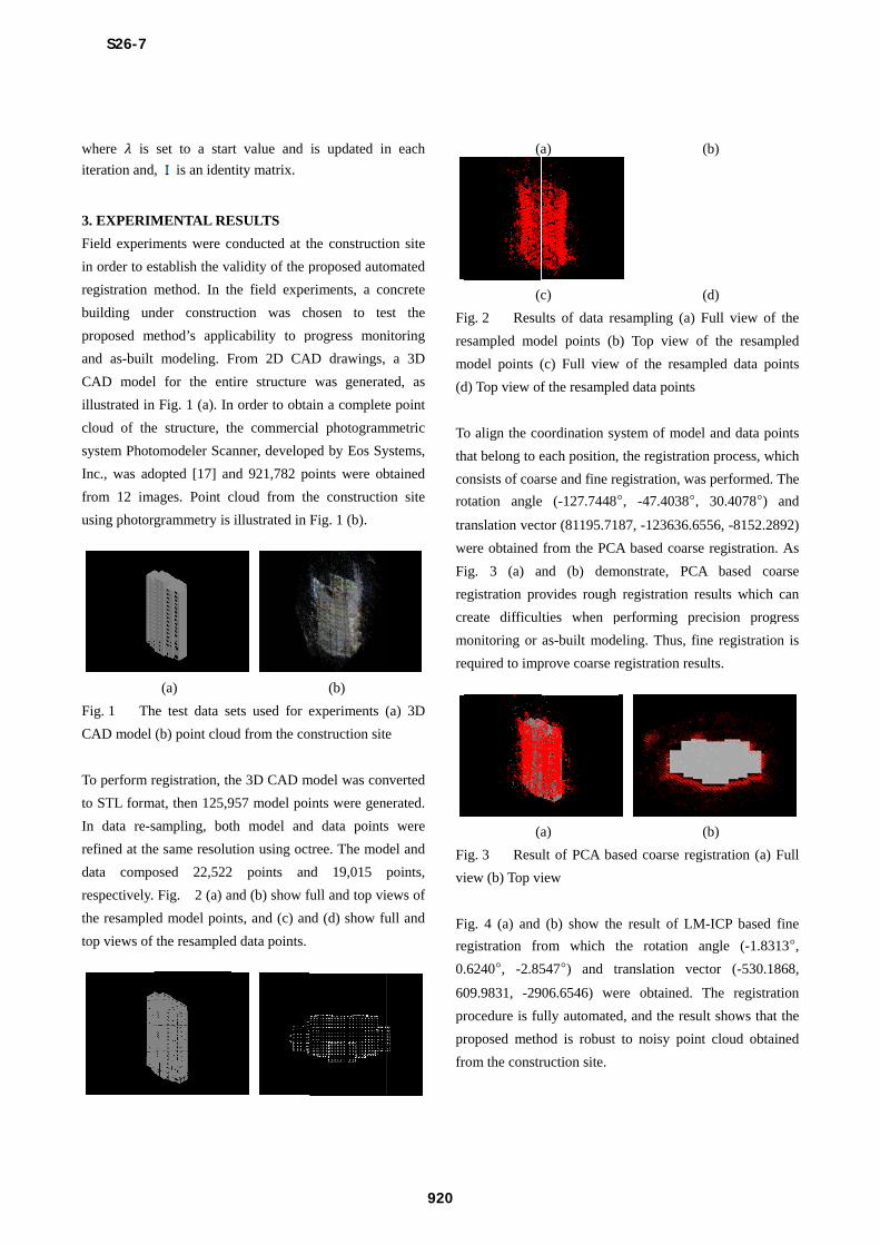
ig. 4 (a) and
egistration fr
.6240°, -2.85
09.9831, -29
rocedure is fu
roposed meth
rom the constr
a)
c)
ults of data re
del points (b
(c) Full view
f the resample
oordination sy
each position,
rse and fine re
e (-127.7448°
tor (81195.71
from the PCA
nd (b) dem
ovides rough
lties when p
as-built mode
prove coarse r
a)
ult of PCA bas
iew
(b) show the
om which t
547°) and tr
06.6546) we
ully automated
hod is robust
ruction site.
esampling (a)
b) Top view
w of the resam
ed data points
ystem of mode
the registratio
egistration, wa
°, -47.4038°,
87, -123636.6
A based coars
monstrate, PC
registration r
performing pr
eling. Thus, fi
egistration res
sed coarse reg
e result of LM
the rotation
ranslation ve
re obtained.
d, and the resu
to noisy poin
(b)
(d)
Full view of
of the resam
mpled data po
el and data po
on process, w
as performed.
, 30.4078°)
6556, -8152.28
se registration
CA based co
results which
recision prog
fine registratio
sults.
(b)
gistration (a)
M-ICP based
angle (-1.83
ector (-530.1
The registra
ult shows that
nt cloud obta
f the
mpled
oints
oints
which
The
and
892)
n. As
oarse
can
gress
on is
Full
fine
313°,
868,
ation
t the
ained
S26-7
920
Page 5
(a) (b)
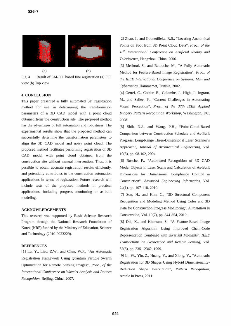
Fig. 4 Result of LM-ICP based fine registration (a) Full
view (b) Top view
4. CONCLUSION
This paper presented a fully automated 3D registration
method for use in determining the transformation
parameters of a 3D CAD model with a point cloud
obtained from the construction site. The proposed method
has the advantages of full automation and robustness. The
experimental results show that the proposed method can
successfully determine the transformation parameters to
align the 3D CAD model and noisy point cloud. The
proposed method facilitates performing registration of 3D
CAD model with point cloud obtained from the
construction site without manual intervention. Thus, it is
possible to obtain accurate registration results efficiently,
and potentially contributes to the construction automation
applications in terms of registration. Future research will
include tests of the proposed methods in practical
applications, including progress monitoring or as-built
modeling.
ACKNOWLEDGEMENTS
This research was supported by Basic Science Research
Program through the National Research Foundation of
Korea (NRF) funded by the Ministry of Education, Science
and Technology (2010-0023229).
REFERENCES
[1] Lu, Y., Liao, Z.W., and Chen, W.F., “An Automatic
Registration Framework Using Quantum Particle Swarm
Optimization for Remote Sensing Images”, Proc., of the
International Conference on Wavelet Analysis and Pattern
Recognition, Beijing, China, 2007.
[2] Zhao, J., and Goonetilleke, R.S., “Locating Anatomical
Points on Foot from 3D Point Cloud Data”, Proc., of the
16th International Conference on Artificial Reality and
Telexistence, Hangzhou, China, 2006.
[3] Meshoul, S., and Batouche, M., “A Fully Automatic
Method for Feature-Based Image Registration”, Proc., of
the IEEE International Conference on Systems, Man and
Cybernetics, Hammamet, Tunisia, 2002.
[4] Oertel, C., Colder, B., Colombe, J., High, J., Ingram,
M., and Sallee, P., “Current Challenges in Automating
Visual Perception”, Proc., of the 37th IEEE Applied
Imagery Pattern Recognition Workshop, Washington, DC,
2008.
[5] Shih, N.J., and Wang, P.H., “Point-Cloud-Based
Comparison between Construction Schedule and As-Built
Progress: Long-Range Three-Dimensional Laser Scanner’s
Approach”, Journal of Architectural Engineering, Vol.
10(3), pp. 98-102, 2004.
[6] Bosche, F., “Automated Recognition of 3D CAD
Model Objects in Laser Scans and Calculation of As-Built
Dimensions for Dimensional Compliance Control in
Construction”, Advanced Engineering Informatics, Vol.
24(1), pp. 107-118, 2010.
[7] Son, H., and Kim, C., “3D Structural Component
Recognition and Modeling Method Using Color and 3D
Data for Construction Progress Monitoring”, Automation in
Construction, Vol. 19(7), pp. 844-854, 2010.
[8] Dai, X., and Khorram, S., “A Feature-Based Image
Registration Algorithm Using Improved Chain-Code
Representation Combined with Invariant Moments”, IEEE
Transactions on Geoscience and Remote Sensing, Vol.
37(5), pp. 2351-2362, 1999.
[9] Li, W., Yin, Z., Huang, Y., and Xiong, Y., “Automatic
Registration for 3D Shapes Using Hybrid Dimensionality-
Reduction Shape Description”, Pattern Recognition,
Article in Press, 2011.
S26-7
921
Page 6
[10] Lee, K.H., Woo, H., and Suk, T., “Point Data
Reduction Using 3D Grids”, The International Journal of
Advanced Manufacturing Technology, Vol. 18(3), 201-210,
2001.
[11] Chung, D.H., Yun, Y.D., and Lee, S.U., “Registration
of Multiple-Range Views Using the Reverse-Calibration
Technique”, Pattern Recognition, Vol. 31(4), pp. 457-464,
1998.
[12] Salvi, J., Matabosch, C., Fofi, D., and Forest, J., “A
Review of Recent Range Image Registration Methods with
Accuracy Evaluation”, Image and Vision Computing, Vol.
25(5), pp. 578-596, 2007.
[13] Besl, P.J., and McKay, N.D., “A Method for
Registration of 3-D Shapes”, IEEE Transactions on
Pattern Analysis and Machine Intelligence, Vol. 14(2), pp.
239-256, 1992.
[14] Du, S., Zheng, N., Ying, S., and Liu, J., “Affine
Iterative Closest Point Algorithm for Point Set
Registration”, Pattern Recognition Letters, Vol. 31(9), pp.
791-799, 2010.
[15] Fitzgibbon, A.W., “Robust Registration of 2D and 3D
Point Sets”, Image and Vision Computing, Vol. 21(13-14),
pp. 1145-1153, 2003.
[16] Lomonsov, E., Chetverikov, D., and Ekart, A., “Pre-
Registration of Arbitrarily Oriented 3D Surfaces Using a
Genetic Algorithm”, Pattern Recognition Letters, Vol.
27(11), 1201-1208, 2006.
[17] Eos Systems, Inc.
http://www.photomodeler.com/index.htm, last accessed on
April 12 2010.
S26-7
922