FUTURE OF LAND IMAGING FUTURE OF LAND IMAGING U.S. Land Imaging U.S. Land Imaging Needs & Needs & Long-Term Continuity Long-Term Continuity Future of Land Imaging Future of Land Imaging Interagency Working Group Interagency Working Group (FLI-IWG) (FLI-IWG) U.S. Group on Earth Observations U.S. Group on Earth Observations Committee on Environment and Natural Committee on Environment and Natural Resources Resources National Science and Technology National Science and Technology Council Council Executive Office of the Executive Office of the President President Washington, DC Washington, DC
Transcript
FUTURE OF LAND FUTURE OF LAND IMAGINGIMAGING
U.S. Land Imaging Needs &U.S. Land Imaging Needs &Long-Term ContinuityLong-Term Continuity
Future of Land ImagingFuture of Land Imaging
Interagency Working GroupInteragency Working Group(FLI-IWG)(FLI-IWG)
U.S. Group on Earth ObservationsU.S. Group on Earth Observations
Committee on Environment and Natural ResourcesCommittee on Environment and Natural Resources
National Science and Technology CouncilNational Science and Technology Council
Executive Office of the PresidentExecutive Office of the President
Washington, DCWashington, DC
April 20, 2006April 20, 2006 22Future of Land Imaging – Interagency Working Group
AGENDAAGENDA
Background – Land Imaging Policy History – OSTP Memoranda
What is Land Imaging ?– Moderate Resolution Imagery is …– Moderate Resolution Imagery is Important because …
The National Science and Technology Council Study Process – Scope and Charter of the FLI-IWG– Assumptions– Needs Analysis -- What are the Societal Benefits ?– Options for Meeting U.S. Land Imaging Needs– Governance Options
How You Can Become Involved
April 20, 2006April 20, 2006 33Future of Land Imaging – Interagency Working Group
Since 1972, the U.S. has flown Landsat – for Agriculture, Forestry, Since 1972, the U.S. has flown Landsat – for Agriculture, Forestry, Mapping, Geology, and a variety of other scientific and Mapping, Geology, and a variety of other scientific and operational usesoperational uses
In 1979, the U.S. attempted, but failed, to commercialize LandsatIn 1979, the U.S. attempted, but failed, to commercialize Landsat In 1992, the U.S. Congress established The Land Remote Sensing In 1992, the U.S. Congress established The Land Remote Sensing
Policy ActPolicy Act– Suspended commercialization attempts and authorized Landsat 7Suspended commercialization attempts and authorized Landsat 7– Adopted the Landsat Data Availability PolicyAdopted the Landsat Data Availability Policy
International Open Skies TreatyInternational Open Skies Treaty Non-Discriminatory User AccessNon-Discriminatory User Access
– Provided for Commercial Licensing, Advanced Technology, and Applications Provided for Commercial Licensing, Advanced Technology, and Applications Research ProgramsResearch Programs
In 2003, the U.S. attempted, but failed, to establish a Public-In 2003, the U.S. attempted, but failed, to establish a Public-Private Partnership for Landsat Data ContinuityPrivate Partnership for Landsat Data Continuity
BACKGROUNDBACKGROUNDLand Imaging Policy HistoryLand Imaging Policy History
April 20, 2006April 20, 2006 44Future of Land Imaging – Interagency Working Group
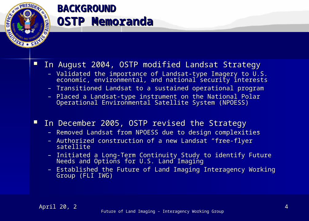
In August 2004, OSTP modified Landsat StrategyIn August 2004, OSTP modified Landsat Strategy– Validated the importance of Landsat-type Imagery to U.S. economic, Validated the importance of Landsat-type Imagery to U.S. economic,
environmental, and national security interestsenvironmental, and national security interests– Transitioned Landsat to a sustained operational programTransitioned Landsat to a sustained operational program– Placed a Landsat-type instrument on the National Polar Operational Placed a Landsat-type instrument on the National Polar Operational
Environmental Satellite System (NPOESS)Environmental Satellite System (NPOESS)
In December 2005, OSTP revised the StrategyIn December 2005, OSTP revised the Strategy– Removed Landsat from NPOESS due to design complexitiesRemoved Landsat from NPOESS due to design complexities– Authorized construction of a new Landsat “free-flyer” satelliteAuthorized construction of a new Landsat “free-flyer” satellite– Initiated a Long-Term Continuity Study to identify Future Needs and Initiated a Long-Term Continuity Study to identify Future Needs and
Options for U.S. Land ImagingOptions for U.S. Land Imaging– Established the Future of Land Imaging Interagency Working Group Established the Future of Land Imaging Interagency Working Group
(FLI IWG)(FLI IWG)
BACKGROUNDBACKGROUNDOSTP MemorandaOSTP Memoranda
April 20, 2006April 20, 2006 55Future of Land Imaging – Interagency Working Group
The characteristics of satellite imaging required to obtain:– Accurate spectral and spatial information– Frequent synoptic views of the Earth– Precise geo-referenced data for mapping and monitoring – Scaleable geospatial information across global, hemispheric,
continental, regional, and local geographies Data calibrated to a national standard over time -- for
measuring real physical changes to the Earth Information about:
– Earth’s geology, hydrology, climatology, biology, and other natural system sciences
– The habitability, sustainability, and quality of life on our planet– Society’s physical, economic, and social infrastructure– Ways to mitigate and respond to human-caused and natural disasters
WHAT IS LAND IMAGING ?WHAT IS LAND IMAGING ?Moderate Resolution Imagery is Moderate Resolution Imagery is ……
April 20, 2006April 20, 2006 66Future of Land Imaging – Interagency Working Group
WHAT IS LAND IMAGING ?WHAT IS LAND IMAGING ?Moderate Resolution Imagery is Important because …Moderate Resolution Imagery is Important because …
Land Imaging directly Land Imaging directly benefits Societybenefits Society– Agriculture and ForestryAgriculture and Forestry– Land Use Planning and Land Use Planning and
ManagementManagement– Coastal Zone ManagementCoastal Zone Management– Ecological ForecastingEcological Forecasting– National / Homeland SecurityNational / Homeland Security– Transportation Management Transportation Management
and Infrastructure Planningand Infrastructure Planning
April 20, 2006April 20, 2006 77Future of Land Imaging – Interagency Working Group
Led by the National Science and Technology Council, with representatives from:– National Aeronautics and Space Administration– U.S. Department of the Interior / U.S. Geological Survey– U.S. Department of Agriculture– U.S. Department of Defense – National Geospatial Intelligence Agency– National Oceanic and Atmospheric Administration
Conduct Fact-Finding and Needs Assessment– Why does the U.S. need Moderate-Resolution Land Images ?– What are the Options for acquiring these Capabilities or Data ?– How should U.S. Land Imaging be managed ?
Produce “a long-term plan… in accord with the goals and objectives of the U.S. Integrated Earth Observation System.”
Report in early 2007 with 2nd and 3rd Qtr 2006 Interim Reports
THE NSTC STUDY PROCESSTHE NSTC STUDY PROCESSScope and Charter of the FLI-Scope and Charter of the FLI-IWGIWG
April 20, 2006April 20, 2006 88Future of Land Imaging – Interagency Working Group
THE NSTC STUDY PROCESSTHE NSTC STUDY PROCESSAssumptionsAssumptions
Continuity of the U.S. Land Data Record Continuity of the U.S. Land Data Record will bewill be maintainedmaintained
… … but Landsat but Landsat will notwill not constrain future U.S. Land constrain future U.S. Land Imaging capabilities and designsImaging capabilities and designs
Alternatives should meet the Landsat Data Alternatives should meet the Landsat Data Continuity Standard while addressing additional Continuity Standard while addressing additional U.S. needsU.S. needs– Greater spatial or spectral resolutionGreater spatial or spectral resolution– Greater frequency of coverage and “steerable” imagingGreater frequency of coverage and “steerable” imaging– Multi-purpose Imaging Systems (Radar, Radar hybrids, Multi-purpose Imaging Systems (Radar, Radar hybrids,
Hyperspectral)Hyperspectral)
April 20, 2006April 20, 2006 99Future of Land Imaging – Interagency Working Group
The FLI-IWG will inventory and assess the societal benefit of The FLI-IWG will inventory and assess the societal benefit of Land Imaging and how it can best be metLand Imaging and how it can best be met
Societal Benefits are a core feature of the International Global Societal Benefits are a core feature of the International Global Earth Observing System of Systems and the U.S. Integrated Earth Observing System of Systems and the U.S. Integrated Earth Observing SystemEarth Observing System
– WeatherWeather– Natural DisastersNatural Disasters– Ocean ResourcesOcean Resources– Climate Variability and ChangeClimate Variability and Change– Agriculture and ForestryAgriculture and Forestry
There are other Societal Benefits not captured by GEOSS and There are other Societal Benefits not captured by GEOSS and IEOS that are important to meeting U.S. economic and national IEOS that are important to meeting U.S. economic and national security interestssecurity interests
– Land Use Planning and ManagementLand Use Planning and Management– Public Lands Conservation / Management Public Lands Conservation / Management – National Security OperationsNational Security Operations– Transportation Planning / ManagementTransportation Planning / Management
The Vitality and Competitiveness of the U.S. Aerospace Industry The Vitality and Competitiveness of the U.S. Aerospace Industry is also a Primary Considerationis also a Primary Consideration
THE NSTC STUDY PROCESSTHE NSTC STUDY PROCESSNeeds Analysis – What are the Societal Needs Analysis – What are the Societal Benefits ?Benefits ?
– Human Health and Well-BeingHuman Health and Well-Being– Ecological ForecastingEcological Forecasting– Water Resource ManagementWater Resource Management– Energy Resource ManagementEnergy Resource Management
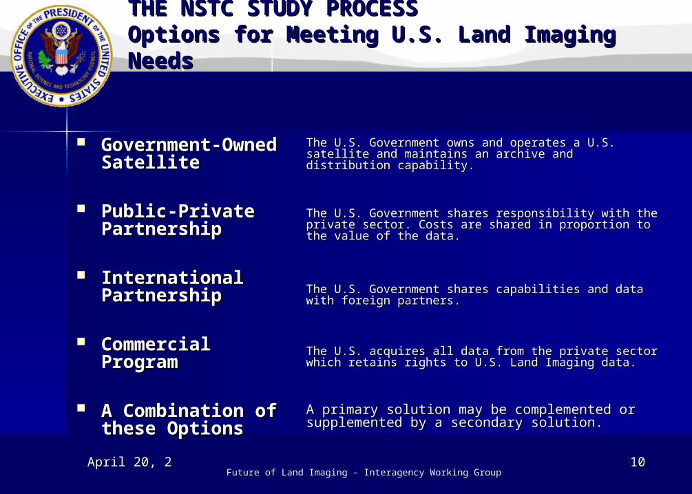
International International PartnershipPartnership
Commercial Commercial ProgramProgram
A Combination of A Combination of these Optionsthese Options
THE NSTC STUDY PROCESSTHE NSTC STUDY PROCESSOptions for Meeting U.S. Land Imaging Options for Meeting U.S. Land Imaging NeedsNeeds
The U.S. Government owns and operates a U.S. satellite The U.S. Government owns and operates a U.S. satellite and maintains an archive and distribution capability.and maintains an archive and distribution capability.
The U.S. Government shares responsibility with the The U.S. Government shares responsibility with the private sector. Costs are shared in proportion to the private sector. Costs are shared in proportion to the value of the data.value of the data.
The U.S. Government shares capabilities and data with The U.S. Government shares capabilities and data with foreign partners.foreign partners.
The U.S. acquires all data from the private sector which The U.S. acquires all data from the private sector which retains rights to U.S. Land Imaging data.retains rights to U.S. Land Imaging data.
A primary solution may be complemented or A primary solution may be complemented or supplemented by a secondary solution.supplemented by a secondary solution.
April 20, 2006April 20, 2006 1111Future of Land Imaging – Interagency Working Group
Single AgencySingle Agency
Multiple AgencyMultiple Agency
Integrated Integrated Program OfficeProgram Office
U.S. National U.S. National CommissionCommission
No U.S. No U.S. Government Government ManagerManager
THE NSTC STUDY PROCESSTHE NSTC STUDY PROCESSGovernance OptionsGovernance Options
A single U.S. Federal Agency is responsible for all A single U.S. Federal Agency is responsible for all aspects of Land Imaging.aspects of Land Imaging.
Two or more Federal Agencies are responsible for all Two or more Federal Agencies are responsible for all aspects of Land Imaging.aspects of Land Imaging.
An IPO reporting to multiple Federal Agencies is An IPO reporting to multiple Federal Agencies is responsible for all aspects of Land Imaging.responsible for all aspects of Land Imaging.
A U.S. National Commission manages the U.S. Land A U.S. National Commission manages the U.S. Land Imaging Program, assigning responsibility for Land Imaging Program, assigning responsibility for Land Imaging.Imaging.
The U.S. acquires all Land Imaging data commercially The U.S. acquires all Land Imaging data commercially or from international sources. No U.S. Federal Agency or from international sources. No U.S. Federal Agency is assigned responsibility.is assigned responsibility.
April 20, 2006April 20, 2006 1212Future of Land Imaging – Interagency Working Group
We need your input !We need your input !
You can view Future of Land Imaging information You can view Future of Land Imaging information atat