www.insidegnss.com september 2006 InsideGNSS 51 Galileo service s: Industry’s role in building Galileo markets T he launch of the GIOVE-A sat- ellite in December 2005 began paving the future road for GNSS applications. Despite dismal predictions, Europe has worked effi- ciently, so far, to establish an indepen- dent GNSS: Galileo. And many positive indications suggest that the road will not stop here. Galileo will transmit a variety of sig- nals in space supporting open, commer- cial, safety-of-life, and public regulated services. In the development of applica- tions based on these services, industry needs to take an active role in the defini- tion process. Manufacturers and service provid- ers possess unique knowledge about the market as well as know-how in the area of industrialization. Furthermore, from the Galileo marketing point of view, industry has well-defined channels for securing fast adoption and diffusion of technology, which is a key criterion for a rapid and successful acceptance of Gali- leo applications, products, and services in the marketplace. In this context Galileo Services plays an important role, as the members of the association represent all aspects of the downstream industry –from prod- uct and service development to deploy- ment. table 1 lists the current members of the association and their fields of expertise. Members of Galileo Services have and will continue to raise crucial issues around technology and solutions for applications and services to be imple- mented with Galileo. ey also are play- ing important roles in leading Galileo research and development projects, pri- marily funded by the European Com- mission (EC). table 2 describes these projects and the Galileo Services mem- ber acting as the coordinator of each. (All of these projects are funded under the EC’s Sixth Framework Program except for ARMAS III, funded by the European Space Agency, which is dis- cussed later in more detail). To illustrate the crucial roles that industry plays in advancing Galileo and expanding the GNSS market in general, this article will describe Euro- pean efforts to implement electronic road tolling systems that incorporate Galileo-based positioning. It will also discuss the need for developing accu- rate mapbases in implementing such Galileo service s: Industry’s role in building Galileo markets Unlike the other leading GNSS systems built as purely governmental programs, Galileo has long been promoted as a public-private partnership in which private companies share responsibilities for designing, implementing, operating, and contributing financial support. Usually, this is conceived in terms of the various consortia formed to compete for contracts to build the system infrastructure and operate the concession. However, “downstream” equipment and services providers are also carving out a stake in researching and developing applications markets. serGIo barbedo SkySoft mIGuel ÁnGel martínez olaGüe GMV rob van essen tele AtlAS lIévIn QuoIdbach NAVteq Jean-pIerre barboux thAleS Gard ueland koNGSberG SeAtex ESA/Enviat
Transcript
www.insidegnss.com s e p t e m b e r 2 0 0 6 InsideGNSS 51
Galileo services: Industry’s role in building Galileo markets
T he launch of the GIOVE-A sat-ellite in December 2005 began paving the future road for GNSS applications. Despite dismal
predictions, Europe has worked effi-ciently, so far, to establish an indepen-dent GNSS: Galileo. And many positive indications suggest that the road will not stop here.
Galileo will transmit a variety of sig-nals in space supporting open, commer-cial, safety-of-life, and public regulated services. In the development of applica-tions based on these services, industry needs to take an active role in the defini-tion process.
Manufacturers and service provid-ers possess unique knowledge about the market as well as know-how in the area of industrialization. Furthermore, from
the Galileo marketing point of view, industry has well-defined channels for securing fast adoption and diffusion of technology, which is a key criterion for a rapid and successful acceptance of Gali-leo applications, products, and services in the marketplace.
In this context Galileo Services plays an important role, as the members of the association represent all aspects of the downstream industry –from prod-uct and service development to deploy-ment. table 1 lists the current members of the association and their fields of expertise.
Members of Galileo Services have and will continue to raise crucial issues around technology and solutions for applications and services to be imple-mented with Galileo. They also are play-
ing important roles in leading Galileo research and development projects, pri-marily funded by the European Com-mission (EC). table 2 describes these projects and the Galileo Services mem-ber acting as the coordinator of each. (All of these projects are funded under the EC’s Sixth Framework Program except for ARMAS III, funded by the European Space Agency, which is dis-cussed later in more detail).
To illustrate the crucial roles that industry plays in advancing Galileo and expanding the GNSS market in general, this article will describe Euro-pean efforts to implement electronic road tolling systems that incorporate Galileo-based positioning. It will also discuss the need for developing accu-rate mapbases in implementing such
Galileo services: Industry’s role in building Galileo markets
Unlike the other leading GNSS systems built as purely governmental programs, Galileo has long been promoted as a public-private partnership in which private companies share responsibilities for designing, implementing, operating, and contributing financial support. Usually, this is conceived in terms of the various consortia formed to compete for contracts to build the system infrastructure and operate the concession. However, “downstream” equipment and services providers are also carving out a stake in researching and developing applications markets.
serGIo barbedoSkySoft
mIGuel ÁnGel martínez olaGüe GMVrob van essen
tele AtlAS
lIévIn QuoIdbachNAVteq
Jean-pIerre barbouxthAleS
Gard ueland koNGSberG SeAtex ESA/Enviat
52 InsideGNSS s e p t e m b e r 2 0 0 6 www.insidegnss.com
galileoservices
systems. And it will explore how Gali-leo can exploit the technical advantage of signal authentication in its system design to build trust in Galileo’s com-mercial services.
Finally, at the conclusion of this arti-cle, we will return to the role of Galileo Services, recent developments, and its plans for the future.
galileo-BasedroadTollingThe conventional model for financing road-transport infrastructure is cur-rently being re-examined both in Europe and elsewhere in the world. Traditional tax-based financing no longer guaran-tees sufficient revenue with which to meet the road-building, upgrading, and maintenance needs of highways and motorways.
As governments move towards taxa-tion systems that reflect use (for exam-ple, waste charges, water charges, and so forth), the choice of moving to “pay as you drive” for use of a member-state’s infrastructure becomes appealing. In a revision to the Eurovignette Directive (1999/62/EC), the EC has outlined the principle that maintenance of the core European motorway infrastructure should be paid for by the users through electronic tolling.
The current urban traffic model appears likely to become unsustainable in the medium- to long-term for large metropolitan areas. The cost of growing congestion levels for society as a whole is very high and has led policy makers to develop a new concept, the “congestion charge.” Such a system has been suc-cessfully implemented in London and is
being explored by other cities, including Stockholm, Singapore, and Melbourne.
The concept is very simple: a fee is charged to motorists entering heav-ily congested urban areas. Economists model and calculate this fee on a theo-retical basis by weighing the contribu-tion made by each vehicle to slowing down the rest. Revenue derived from congestion charges is typically spent on new public transport facilities and road infrastructure.
In the case of national road net-works, the number of vehicles on European roads and the capacity of the Europe-wide road network show a glaring and widening deficit in trans-port infrastructure investment (See the citation for the EC White paper: “ Euro-pean transport policy for 2010: time to decide” in the Additional Resources section at the end of this article). Inevi-tably, public officials in charge of taxa-tion policy face the question of who should pay for the maintenance and further required investment in such infrastructure.
One solution that is being deployed in central European countries is to require heavy goods vehicles (HGVs) using their motorways to pay a toll. Germany, Austria, and Switzerland have all introduced such electronic tolling schemes, and last year the Czech Republic awarded a tender to develop such a system for its infrastructure. Sweden, the United Kingdom, and The Netherlands are all looking to imple-ment similar national electronic tolling systems in the medium term.
NewrUcsystemsRoad user charging (RUC) systems have to be very flexible to fit in with the vary-ing rates set on diverse road types in urban, inter-urban, and even rural areas. Such systems must be able, for example, to change the distance or zone-stay cri-teria underpinning the toll from one day to another.
An RUC system also has to be able to take into account the type of vehicle, time of day, day of the week or month, time and/or distance travelled, as well as the starting point and destination
Table 1. Galileo Services is a non-profit making association of Industry covering GNSS applications and services, formed in March 2002 on the eve of the european Council decision to launch the GalIleO program. Its aim is to develop, promote and maximize the potential of the applications’ market. The members are listed.
EADS Space Services Space services provider www.space.eads.net
Euro-Telematik Mobile technology consultant www.euro-telematik.de
TNO Space Defense, security, IT www.tnospace.tno.nl
www.insidegnss.com s e p t e m b e r 2 0 0 6 InsideGNSS 53
of individual trips. Traditional barrier tolling systems are clearly not flexible enough to handle the multiple variables used to design the RUC fee structure.
Two technologies are currently com-peting to serve as the basis for these new electronic toll collection (ETC) systems: dedicated short-range communications (DSRC) — used today in high-speed motorway toll plazas — and GNSS systems such as GPS or Galileo. GNSS systems can provide vehicle position-ing information that is converted into road segments travelled and, ultimately, toll charges. In actual practice, hybrid solutions that use components of both DSRC and satellite systems will ensure interoperability between the two RUC technologies.
gNss-BasedeTcThe best example of GNSS-based ETC is the TollCollect service in Germany for HGVs using Germany’s motorway infra-structure. The basic concept involves use of a vehicle’s GNSS-derived position data to ascertain whether or not it has used the toll road and, if so, to calculate the toll charge. In theory, implementation is fairly simple. It calls only for an onboard device – including a GNSS receiver – and mobile data communication equip-ment connected to an ETC processing center where the vehicle information is received.
This concept has many advantages. Firstly, the charging system can be applied to any road, highway, or motor-way without having to set up costly roadside equipment. Secondly, it makes urban congestion zones feasible for cities where there are no natural boundaries, such as rivers. Monitoring access to and from such areas is prohibitively costly due to the numbers of entrance and exit points. Finally, the system is very flex-ible in applying charging criteria – time of day, vehicle class, etc. A GNSS-based tolling system also has other advantages. A single system is capable of furnishing information for different charging juris-dictions. Moreover, the ETC equipment and infrastructure can also provide other tracking-based functions and value-added services.
For example, a GNSS-based toll sys-tem provides an immense collateral fleet of “floating probes,” for generating real-time traffic information. The toll system components can also be used to provide additional secondary services such as en-route navigation, pay-as-you-drive insurance, fleet management, and even law enforcement.
PubliclyFundedresearchIn parallel with commercial imple-mentations, the EC, European Space Agency (ESA), and Galileo Joint Under-taking (GJU) have funded a number of research projects to examine how EGNOS and Galileo can be used to improve performance of charge calcu-lation and to exploit the integrity infor-mation that both EGNOS and Galileo provide.
Galileo Services (GS) members are involved in two of these projects: Active Road Management Assisted by Satellite
(ARMAS), an ESA-funded project, and GIROADs an EC/GJU-funded project that is preparing the transport sector for the introduction of Galileo.
The ARMAS Project is coordinated by GS member Skysoft Portugal and has the leading participation of other association members, including Logica-CMG, Mapflow, GMV and Euro Tele-matik. ARMAS has demonstrated the feasibility of GNSS technology in trans-forming the transport infrastructure (roads, bridges, tunnels, etc.) into safer and more customer-friendly environ-ments, by improving safety, increasing dynamic traffic management capabili-ties, and providing electronic fee collec-tion mechanisms.
The project followed the technical “constraints” put forward in the EC directive 2004/52/EC on “Interoperabil-ity of electronic road tolling systems in the Community.” So, the ARMAS sys-tem architecture was consequently influ-
Table 2. On-going R&D Projects Coordinated by Galileo Services Members
54 InsideGNSS s e p t e m b e r 2 0 0 6 www.insidegnss.com
enced by the use of various standards, pre-standards, specifications and other technical documents.
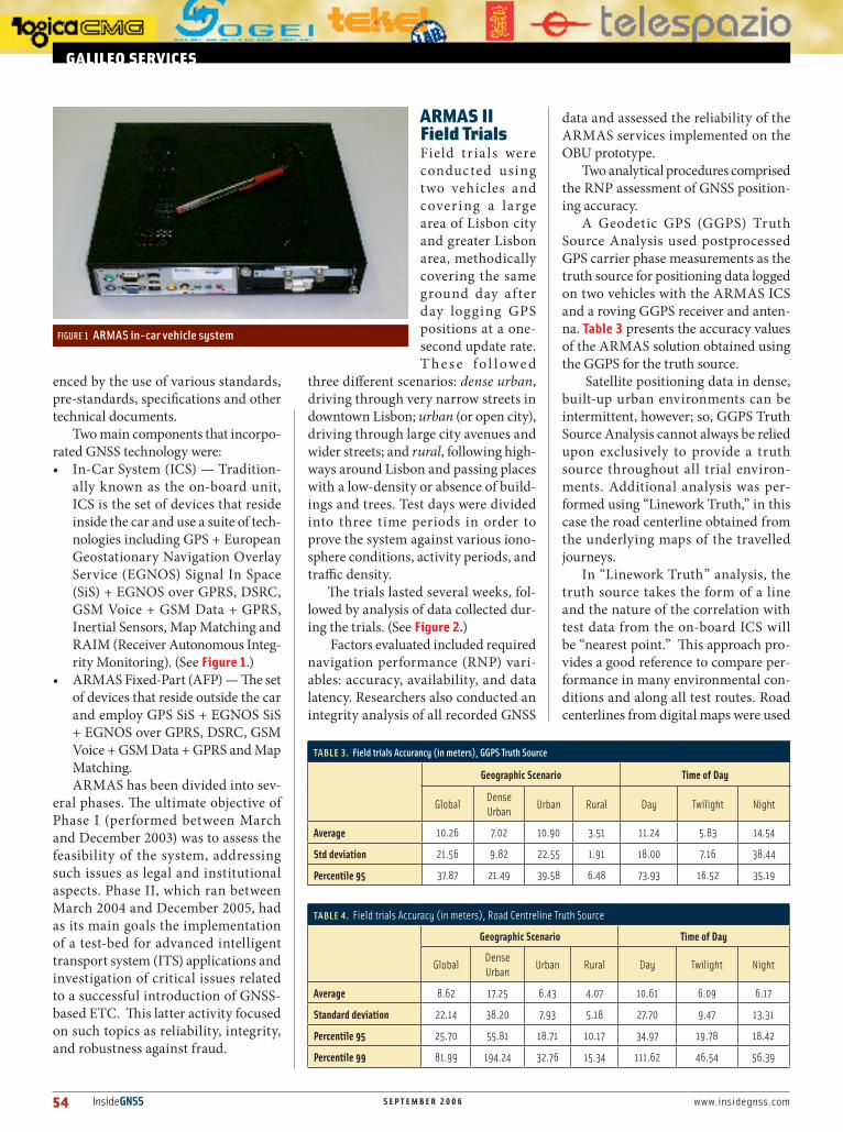
Two main components that incorpo-rated GNSS technology were:• In-Car System (ICS) — Tradition-
ally known as the on-board unit, ICS is the set of devices that reside inside the car and use a suite of tech-nologies including GPS + European Geostationary Navigation Overlay Service (EGNOS) Signal In Space (SiS) + EGNOS over GPRS, DSRC, GSM Voice + GSM Data + GPRS, Inertial Sensors, Map Matching and RAIM (Receiver Autonomous Integ-rity Monitoring). (See Figure 1.)
• ARMAS Fixed-Part (AFP) — The set of devices that reside outside the car and employ GPS SiS + EGNOS SiS + EGNOS over GPRS, DSRC, GSM Voice + GSM Data + GPRS and Map Matching.ARMAS has been divided into sev-
eral phases. The ultimate objective of Phase I (performed between March and December 2003) was to assess the feasibility of the system, addressing such issues as legal and institutional aspects. Phase II, which ran between March 2004 and December 2005, had as its main goals the implementation of a test-bed for advanced intelligent transport system (ITS) applications and investigation of critical issues related to a successful introduction of GNSS-based ETC. This latter activity focused on such topics as reliability, integrity, and robustness against fraud.
arMasiiFieldTrialsField tr ia ls were conducted using two vehicles and covering a large area of Lisbon city and greater Lisbon area, methodically covering the same ground day after day logging GPS positions at a one-second update rate. T h e s e f o l l owe d
three different scenarios: dense urban, driving through very narrow streets in downtown Lisbon; urban (or open city), driving through large city avenues and wider streets; and rural, following high-ways around Lisbon and passing places with a low-density or absence of build-ings and trees. Test days were divided into three time periods in order to prove the system against various iono-sphere conditions, activity periods, and traffic density.
The trials lasted several weeks, fol-lowed by analysis of data collected dur-ing the trials. (See Figure 2.)
Factors evaluated included required navigation performance (RNP) vari-ables: accuracy, availability, and data latency. Researchers also conducted an integrity analysis of all recorded GNSS
data and assessed the reliability of the ARMAS services implemented on the OBU prototype.
Two analytical procedures comprised the RNP assessment of GNSS position-ing accuracy.
A Geodetic GPS (GGPS) Truth Source Analysis used postprocessed GPS carrier phase measurements as the truth source for positioning data logged on two vehicles with the ARMAS ICS and a roving GGPS receiver and anten-na. table 3 presents the accuracy values of the ARMAS solution obtained using the GGPS for the truth source.
Satellite positioning data in dense, built-up urban environments can be intermittent, however; so, GGPS Truth Source Analysis cannot always be relied upon exclusively to provide a truth source throughout all trial environ-ments. Additional analysis was per-formed using “Linework Truth,” in this case the road centerline obtained from the underlying maps of the travelled journeys.
In “Linework Truth” analysis, the truth source takes the form of a line and the nature of the correlation with test data from the on-board ICS will be “nearest point.” This approach pro-vides a good reference to compare per-formance in many environmental con-ditions and along all test routes. Road centerlines from digital maps were used
galileoservices
FIGURe 1 ARMAS in-car vehicle system
Table 3. Field trials accurancy (in meters), GGPS Truth Source
www.insidegnss.com s e p t e m b e r 2 0 0 6 InsideGNSS 55
to create the highly accurate linework required for the truth data.
table 4 presents the accuracy and latency values that were obtained using the Road Centreline Truth Source Anal-ysis.
The accuracy demonstrated in the tests coupled with the integrity obtained using EGNOS and RAIM meant that, as expected, the positioning solution pro-vided by GPS+EGNOS+Inertial Sensors is appropriate for the tested tolling situ-ations. Accurate charging was produced although an extensive trial with a large number of vehicles would be necessary for statistical validity.
The only environment where the results are not optimal is the dense urban areas where satellite signals were frequently blocked. As expected, the performance of the system becomes heavily dependent on the performance of inertial sensors, map-matching algo-rithms, and, if applicable, the tolling sce-nario (for example, the definition of the “Charging Zone” boundaries).
The accuracy of the positioning data from the on-board unit, which was designed primarily for testing GNSS-based ETC, easily supported the other two functionalities defined in ARMAS Phase II: “SOS Request” and “Warnings Provision.” This demonstrated that the approach followed is valid for providing additional service- and business-orient-ed functionalities to end customers over and above the ETC application.
The ARMAS project has recently been extended into a 18 months Phase III which will provide significant func-tional and technical enhancements to the ARMAS Phase II system, as well as foster an opportunity for real-life test-ing and benchmarking of the technology developed by the ARMAS consortium. Several demonstrations and extensive trials are planned, including end-user trials in Portugal, Ireland, Netherlands, and Germany. These trials include road user charging in Dublin and Lisbon, traf-fic information in The Netherlands, and incident management in Portugal (moni-toring of “Dangerous Goods Transporta-tion” and monitoring of “Children and Youths Transportation in Buses”).
TheimportanceofgoodMapsGalileo will provide signals from which the geographic coor-dinates of a GNSS receiver’s position can be derived. As such these are of limited value for a computer and even of less value for a human.
I n o r d e r t o e x ploi t t he f u l l potent ia l of t he geographic coor-dinates obtained from the Gali leo signals, these need to be provided with a real world con-text. Where exactly on earth are these coordinates locat-ed? What is in the surroundings of this position? How far is it to another g i ve n lo c a t ion? These questions can be answered when the coordinates are matched to a map that supports the coordinate system of Galileo, known as the Galileo Reference Frame.
In the 1980s Galileo Services part-ners Tele Atlas and Navteq started to build digital road maps. These maps are used in a wide variety of applications ranging from disaster management to vehicle and personal navigation. (See Figure 3.)
Digital maps contain information of the earth’s surface with an emphasis on street, road, and highway networks. In the digital map database, road center lines are tagged with address informa-tion (e.g. street names, house numbers, postal districts) and traffic-related infor-mation (e.g., road classification, one-way regulations, forbidden turns, etc.) on top of their geometry.
Further, the databases may con-tain points-of-interest (POIs) with a wide-ranging collection of locations of potential interest to a user. Typical examples include churches, museums, restaurants, ATMs, and parking garag-es. Additional cartographic information such as bodies of water, railways, built-up areas, and forests may also reside in the databases.
Mobile applications for which these maps are intended typically employ a GPS receiver as well. GPS receivers cal-culate their position coordinates in the World Geodetic System 1984 (WGS84)). The map datum incorporated into GPS units is also defined in terms of WGS84.
Upon receiving a set of WGS84 coor-dinates, the mobile application usually
FIGURe 2 ARMAS test vehicle with GPS antenna visible on roof rack
FIGURe 3 Personal Navigation device with a digital map displayed in “bird’s-eye” view on the screen
56 InsideGNSS s e p t e m b e r 2 0 0 6 www.insidegnss.com
matches the coordinates with the geom-etry of objects in the digital map and derives a location in terms of a map ele-ment, such as a road segment— provid-ing that “real-world context to a coordi-nate” mentioned earlier.
With this location information, the application is then able to perform its chosen function, such as finding POIs in the vicinity of the user, calculating a route to a user defined destination, and guiding the user to that location. Certain applications are connected to external sources of information that add to the informational richness of the system and allow the use of dynamic information to help optimize the routing.
MaintainingMapaccuracyThe difference between the Galileo Refer-ence Frame and WGS84 are minimal so that maps developed for WGS84-based systems can also be used with Galileo-based systems. Currently available maps have an accuracy of 5 to 10 meters. By the time Galileo becomes fully operational, the positioning accuracy requirements of applications are expected to increase to around 2 meters.
Some prospective applications have indicated a need for map accuracy at the centimeter level. It is fair to say, that business models for such high-accu-racy mobile applications have yet to be presented. Nonetheless, to meet such requirements should they become prac-tically useful, providers of digital map databases are currently improving the
accuracy of their maps.
As in most com-mercial endeavors, economic consider-ations are important for choosing appro-priate technology. Aerial imagery is a possible source. A more frequent means to achieving the necessary accu-racies, however, is the field collection of road coord i-nates by driving the
streets with an accurately positioned vehicle. In the absence of Galileo sig-nals, alternative positioning means such as differential GPS and inertial systems need to be incorporated into field data collection units.
The accompanying photo shows a TeleAtlas truck that registers the track of the vehicle with an accuracy of two meters (2σ). (See Figure 4.)Position off-sets caused by left/right-hand driving are automatically corrected by image-recognition techniques, which focus on the road center line in images captured by two forward-pointing stereoscopic cameras.
The emphasis on field collection of map information points to another important phenomenon associated with digital maps: They slowly become out-dated from the moment they have been published. Updating maps, therefore, is an important ancillary activity of the mapmakers. Field data collection is nec-essary here, but not sufficient. To sup-port updates, mapmakers also maintain extensive contacts with public authori-ties who are in charge of the ever-chang-ing reality of the physical world that we live and move about in.
These contacts allow them to be “pre-actual.” For instance, knowledge of transportation infrastructure projects and plans enables mapmakers to include a new motorway intersection in a map before the intersection is opened so that at the time of publication the map is up-to-date. In order to streamline this
process, the Digital Maps working group of the EC’s eSafety forum recently pub-lished a final report that recommends a cooperation model between the map-makers and public authorities. (For more details, see the Internet site referenced in the Additional Resources section at the end of this article)
MoreThanMapDatabasesApart from accuracy and quality require-ments, the new Galileo-enabled applica-tions will also result in expanded content requirements. Road tolling applications will require details such as toll gates and fees to be incorporated into digital map databases so that motorists can antici-pate their travel costs. Fee information will likely have a dynamic character and, therefore, needs to be integrated into the map in real-time. Techniques such as the Agora-C on-the-fly location referencing, developed with funding of the EC’s Fifth Framework program, are appropriate mechanisms for that.
Upcoming mandates for vehicular automatic emergency calling (eCall) applications will need eCall locations to be added to digital maps, while dan-gerous goods monitoring will require forbidden zones, dedicated routes, and parking places. No technical hurdles are expected in this extension pro-cess, which will be mainly governed by business parameters. Standardiza-tion requirements can be addressed in databases compliant with guidelines of the International Organization for Stan-dards Technical Committee 204 (ISO/TC 204: Intelligent Transport Systems) Working Group 3.
Continuous production has resulted in maps that currently cover the entire western Europe, North America, and important parts of eastern Europe, Middle East, South America, and Asia. By the time Galileo is operational, map databases will be available that make the system’s satellite signals fully use-ful.
Recently, the European Union (EU) funded the GST-CERTECS project, which looked at the issue of map certi-fication for safety- and liability-critical applications. Navteq developed the Geo-
FIGURe 4 Vehicle for field collection of coordinates and additional map information
galileoservices
www.insidegnss.com s e p t e m b e r 2 0 0 6 InsideGNSS 57
graphic Data Quality Inspection (GDQI) to support the certification process. (See Figure 5.) Major European OEMs and a certification body are now testing and validating GDQI, after which it will be proposed to all stakeholders.
ingalileoWeTrustMarket analysis studies (GEMINUS, GALILEI) conducted during the Galileo Definition Phase suggested that a num-ber of very large mass market applica-tions will exist for GNSS in the future. Some of these will require the use of loca-tion systems linked to charging schemes, for example, road tolling, which has already been discussed, or “smart car” insurance that sets rates based on actual vehicle usage. A substantial portion of Galileo revenues is projected to come from such application markets.
As with any system that includes a charging scheme, customers will insist on a very high level of trustworthiness in the overall system. They will also seek strong assurances that what they pay fairly represents their use of the system, service, or facility for which they are being charged.
In a very symmetric way, service providers will want confidence that the system provides:• A high level of availability (percent-
age of users charged – e.g. 99.9%)• A high level of integrity (very low
percentage of incorrect charging)• A high level of security against fraud
and evidence for enforcement.Let us take just one example, por-
trayed simply in Figure 6. (Undoubtedly, many complex designs will arise for sim-ilar systems requiring signal authentica-tion, but the diagram will suffice for the points that need to be made.)
The application outlined in the figure represents a road-tolling system of some sort. In it, a user vehicle with a Galileo-capable receiver, possibly integrated with other sensors in the on-board unit (OBU), receives GNSS signals from which it calculates ranges to the satellites. Vehicle position (and perhaps speed) is computed from the ranges. Periodically, the vehicle submits a distance travelled log, and the user receives a bill. The user
pays the bill to the toll operator.
W i t h i n t h e overall application boundary of Figure 6 are a number of “transactions” or events where data moves between the subsystems. The arrows represent these data f lows. Because users will one day get a bill for the service, they can be expected to demand — and must be provided with — a highly trustworthy sys-tem.
The application provider must build it s sys tem w it h trustworthy blocks, connected by trust-worthy links. If any trust sub-system fails, the customer base will reject the system – and rightly so. Therefore, when the application inte-grator reaches for the GNSS block, it will only be included in the application if the GNSS and its signal link are as trustwor-thy as the overall system.
So, the system and its subsystems must work properly, and a fair bill must be presented. A robust design and thor-ough, certified testing achieve this aim.
gamingthesystemHowever, because payments are expect-ed, experience shows that some people will try to find ways of avoiding the payments. This avoidance could include deliberately tampering with some part or parts of the on-board system to cause a false log to be generated at a lower than true mileage; and electronic jamming or spoofing of GNSS signals in an attempt to trick the system into calculating a low mileage.
Finally, there are always those indi-viduals who seek to disrupt the system,
just for the intellectual challenge – like the Internet hackers and virus frater-nity. This threat may only be addressed by keeping one technological step ahead of the attacker. Effective defense must stretch broadly and reach deep within the signal and the terminal.
Sadly, very little can be done about jamming without moving to very expen-sive antijam hardware solutions – which are just not practical for mass-market systems. The antijamming capability for most GNSS consumer applications will be mainly provided by signal diversity and spread spectrum signal process-ing. Here, the real protection will be intelligent receiver design, backed by the enforcement of legislation by the authorities.
Attacks on the “trust” capabilities within such systems will most likely be very localised. No doubt, many will attempt to tinker with their in-car logging system, and anti-tampering
FIGURe 5 The quality triangle (Source Navteq)
FIGURe 6 A road-tolling application scenario
58 InsideGNSS s e p t e m b e r 2 0 0 6 www.insidegnss.com
designs for the terminals will provide a major protection of the trust bound-ary.
Spoofing is clearly possible but would require a high degree of sophistication to spoof an integrated terminal design. Techniques may be embedded in the signal and receiver to help mitigate the effects.
The trust regime for the entire end-to-end system must therefore:• provide a sound technical solution
that generates fair bills• be tamper resistant and indicate that
tampering has been attempted• be robust to spoofing hacker-type
attacks via the (many) inputs.
Service providers will build the over-all road-tolling system or other fee-based applications, but the Galileo Operating Company (GOC) provides the GNSS signal – or at least the Galileo part of it. Therefore, if the GOC wishes the signal to be used in such applications in order to derive fees from a value-added service, then the design of the signal must cater to this high degree of trust that must be placed upon it.
The remainder of the discussion on this topic will concentrate on how the trust capability can be implemented in the Galileo signals, recognising that GNSS is just a constituent part of the trust features of the overall application. Furthermore, in order to fit our signals seamlessly into the overall trust regime, we must understand how the other areas provide their trust elements so that we augment, rather than conflict with, the overall design.
signalauthenticationWhatever these “Trust” features are, they must meet user expectations for reliability, robustness, and integrity.
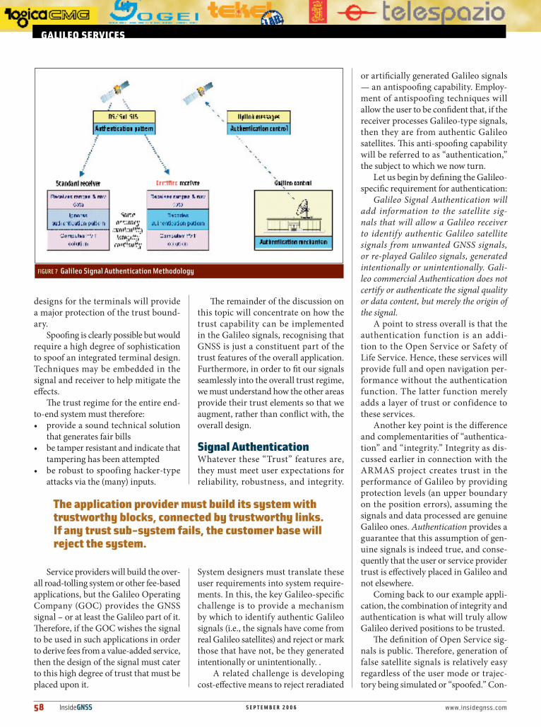
System designers must translate these user requirements into system require-ments. In this, the key Galileo-specific challenge is to provide a mechanism by which to identify authentic Galileo signals (i.e., the signals have come from real Galileo satellites) and reject or mark those that have not, be they generated intentionally or unintentionally. .
A related challenge is developing cost-effective means to reject reradiated
or artificially generated Galileo signals — an antispoofing capability. Employ-ment of antispoofing techniques will allow the user to be confident that, if the receiver processes Galileo-type signals, then they are from authentic Galileo satellites. This anti-spoofing capability will be referred to as “authentication,” the subject to which we now turn.
Let us begin by defining the Galileo-specific requirement for authentication:
Galileo Signal Authentication will add information to the satellite sig-nals that will allow a Galileo receiver to identify authentic Galileo satellite signals from unwanted GNSS signals, or re-played Galileo signals, generated intentionally or unintentionally. Gali-leo commercial Authentication does not certify or authenticate the signal quality or data content, but merely the origin of the signal.
A point to stress overall is that the authentication function is an addi-tion to the Open Service or Safety of Life Service. Hence, these services will provide full and open navigation per-formance without the authentication function. The latter function merely adds a layer of trust or confidence to these services.
Another key point is the difference and complementarities of “authentica-tion” and “integrity.” Integrity as dis-cussed earlier in connection with the ARMAS project creates trust in the performance of Galileo by providing protection levels (an upper boundary on the position errors), assuming the signals and data processed are genuine Galileo ones. Authentication provides a guarantee that this assumption of gen-uine signals is indeed true, and conse-quently that the user or service provider trust is effectively placed in Galileo and not elsewhere.
Coming back to our example appli-cation, the combination of integrity and authentication is what will truly allow Galileo derived positions to be trusted.
The definition of Open Service sig-nals is public. Therefore, generation of false satellite signals is relatively easy regardless of the user mode or trajec-tory being simulated or “spoofed.” Con-
FIGURe 7 Galileo Signal Authentication Methodology
www.insidegnss.com s e p t e m b e r 2 0 0 6 InsideGNSS 59
sequently, authentication requires the addition in the signals of some secret “authentication pattern” unpredictable by would-be spoofers.
The diagram in Figure 7 is, again, a simplification, but it captures the outline of the requirement and implementation. “Authentication” blocks are marked in blue.
The Galileo Control Segment is the “owner” of the secret authentication mechanism. Ad hoc commands and data are uploaded into the satellites to permit the generation of the “authenti-cation pattern” and its addition to the broadcast signal in space. “Authen-tication-capable” receivers are fitted with a specific algorithm to decode the received authentication pattern and, when activated with the proper key, to check its validity. “Standard” receivers on the other hand will just ignore the authentication pattern and perform normally.
At the time of writing, specific implementation details are still being discussed between the GOC and the Galileo Joint Undertaking (GJU) regard-ing the authentication service. How-ever, both parties seem to recognise the importance of this feature, which in combination with integrity is a true enabler of GNSS-based “liability critical applications.”
galileo’s“ThirdPartner”The Galileo program is now entering a new phase. The European GNSS Super-visory Authority (GSA) is replacing the GJU and the future concessionaire or the Galileo Operating Company (GOC) will eventually take on the task of deploying and operating the Galileo system. In this process, it is still crucial to have a good link with the ultimate customers of Galileo – namely the end users.
Galileo Services and its members have played a vital role thus far in the Galileo development by establishing and maintaining such links. By already being well grounded as leading players in the GNSS applications and services markets, an excellent basis exists for understand-ing the users requirements of today and those of tomorrow.
To further enhance this position Galileo Services has also adopted new statutes to enable the expansion of the association towards an ever broader representation of GNSS downstream industry and service providers and a wider coverage of markets in the dif-ferent regions of the world. This means that non-European companies that have interests in GNSS and Galileo down-stream applications are also welcome to join the association. The role of Galileo Services is illustrated in Figure 8.
In this new context the mission of the Galileo concessionaire will be to transform the ESA/Galileo Industries system design of Galileo’s space and ground infrastructure into a tool for cre-ating business. Meanwhile, the Galileo Supervisory Authority will consolidate the full public engagement and expec-tations whilst enabling the regulatory environment to enable and facilitate the downstream business development.
Galileo Services has the ambition to continue its role as a key partner regard-ing services and applications for system’s users. In that capacity the association will propose areas of market/business development, innovative business mod-els, and service level agreements; pro-mote the use of Galileo worldwide; stim-ulate R&D (including recommendations for the EU 7th Framework Programme (FP7); assist the program implementa-tion; contribute to standardization and certification process; propose EGNOS/Galileo Systems’ improvements; and
foster user-driven performance of the infrastructures.
One of the main tasks of the associa-tion since its foundation has been to take the position of the users and contribute counsel and advocacy to ensure that Galileo will be in line with users’ needs. This process is ongoing and will also be highly relevant as the concessionaire details its suite of services. With this in mind, Galileo Services aims at establish-ing a close dialog with the concession-aire and the GSA.
An important incentive for devel-oping early applications and services for Galileo are the EU Framework Programs. Within FP7, which starts next year, funds will be allocated for a period of seven years specifically for the development of Galileo applications and services. In addition to the continuation of key Galileo application developments initiated under FP6, in cooperation with the concessionaire, FP7 is expected to focus on a range of activities includ-ing specific applications and services of Galileo enabling technologies, tech-nology integration, signal processing, public interest applications, standard-ization/certification, system evolution, user awareness, demonstrations and promotion, regulated and certified applications, support framework for applications and services, and projects oriented toward small and medium-sized enterprises.
Most of the projects carried out as part of the framework programs have
FIGURe 8 Galileo Services, a key partner for the Galileo Supervisory Authority and the future Galileo Concessionaire
60 InsideGNSS s e p t e m b e r 2 0 0 6 www.insidegnss.com
a substantial financial contribution from the industry. For the industry to invest in these projects it needs to see a potential return on investment. This approach ensures that the development is well founded within the core business activities of the participating companies and is a good insurance that the initia-tives are on the right track.
The involvement of Galileo Services shows that the downstream industry is highly committed to contributing to the development of Galileo, both of the system and its applications and services. The association is ready to take advan-tage of the opportunities presented by Galileo as early as possible in order to develop competitive and sustainable solutions for users worldwide.
ManufacturersThe ARMAS Geodetic GPS (GGPS) used 4000 SSE receivers from Trimble, Sunnyvale, California, USA, and corre-sponding post-processing software.The
ARMAS In-Car System (ICS) incorpo-rated a PolaRx2 single-frequency GNSS/SBAS receiver from Septentrio, Leuven, Belgium. The ICS inertial sensors were MTi inertial measurement units from Xsens, Enschede The Netherlands.


![M-TRADE-ES-DD19 V 1 - galileo.cs.telespazio.itgalileo.cs.telespazio.it/mtrade/public/Download M-TRADE Public... · including feedback on documents provided at KO, see [AD.5]) A. Di](https://static.documents.pub/doc/80x56/5b832cc17f8b9a866e8c788d/m-trade-es-dd19-v-1-m-trade-public-including-feedback-on-documents-provided.jpg)


