81
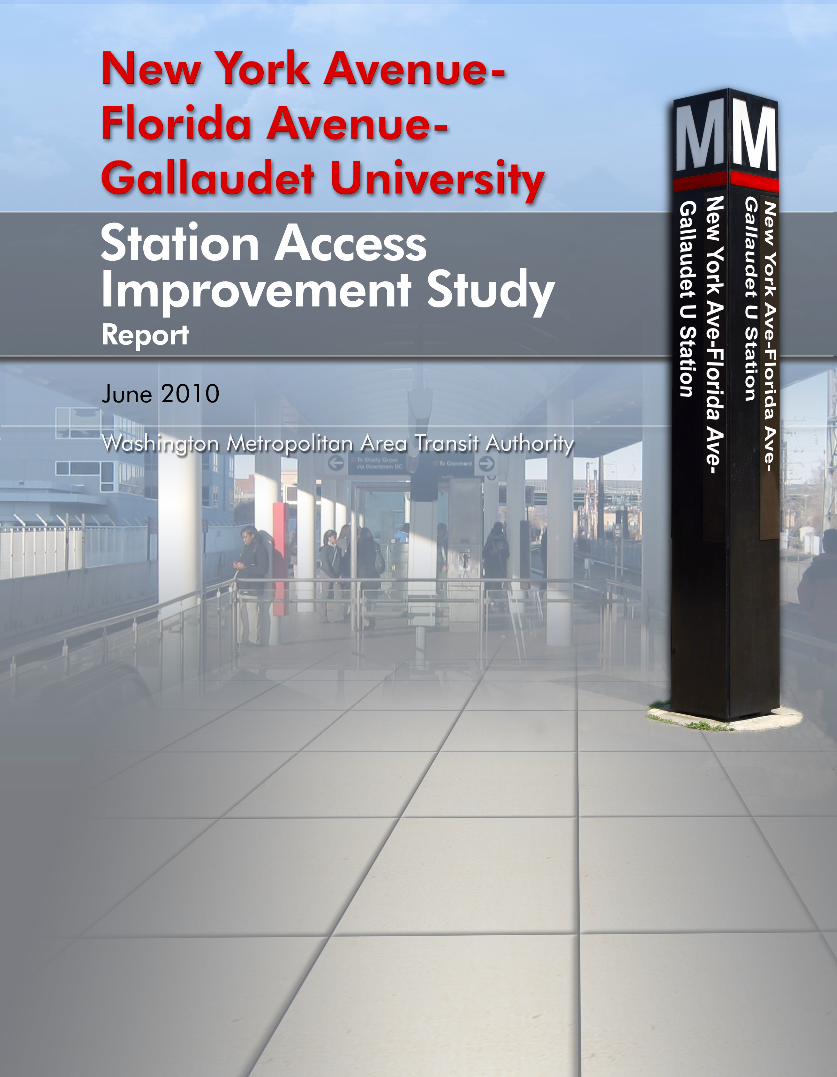


New York Avenue-Florida Avenue-Gallaudet University
Station Access Improvement Study
Report
Washington Metropolitan Area Transit AuthorityDepartment of Planning and Joint Development
Office of Station Area Planning and Asset Management
June 2010
Lead Agency:
Washington Metropolitan Area Transit Authority
Station Area Planning and Asset Management
Steven E. Goldin, DirectorRobin McElhenny, Manager of Station Area Planning
Catherine Jones, Senior Urban Planner
600 5th Street NWWashington, DC 20001
The following agencies and stakeholders were involved in this project, including, but not limited to:
District Department of TransportationDistrict Office of Planning
NoMa Business Improvement DistrictGallaudet University
Various ANCs in Wards 5 and 6
Consultant:
Parsons BrinckerhoffPhilip Braum, Project Manager
Monique Ellis
1401 K Street NWSuite 701
Washington, DC 20005

New York Avenue-Florida Avenue-Gallaudet University Station Access Improvement Study
ContentsExecutive Summary ES-1 Introduction ES-1 Existing Station Area Characteristics ES-1 Community Outreach Activities ES-3 Future Station Area Characteristics ES-3 Station Area Recommendations ES-4
Introduction 1 Purpose 1 History of New York Avenue Station Planning 2 Existing Station Area Characteristics 7 Planning Area 7 Existing Station Area Land Use 8 Station Facilities and Amenities 10 Existing Ridership 11 Transportation Network 12 Safety and Security 22 Amtrak Overpasses 23 Station Environment 23 Community Outreach Activities 29 New York Avenue Station Area Meeting—February 7, 2008 30 Amtrak Site Tour and Meeting—October 1, 2008 30 Outreach and Survey to Advisory Neighborhood Commissioners and Local Community Leaders— December 2008 31 Gallaudet University Meeting—May 6, 2009 31 Community Walkabout and Workshop—June 20, 2009 31 Future Station Area Characteristics 37 Future Station Area Land Use 37 Demographics 40 Metrorail Ridership Forecast 40 Transportation Enhancements 41 Station Area Recommendations 53 Transportation Network 53 Pedestrian Safety 54 Overpasses and Other Infrastructure 54 Wayfinding 54 Station Facilities 54 Aesthetics 54 Land Development 54
Appendix 1: Community Input 61Appendix 2: Endnotes 63
i

New York Avenue-Florida Avenue-Gallaudet University Station Access Improvement Study
List of FiguresFigure ES-1: New York Avenue Station Area ES-2
Figure 1: New York Avenue-Florida Avenue-Gallaudet University Station 1
Figure 2: New York Avenue Station Area 7
Figure 3: Existing Land Uses and Neighborhoods within New York Avenue Station Area 8
Figure 4: Points of Interest within New York Avenue Station Area 9
Figure 5: New York Avenue Station in Relation to Surrounding Area 9
Figure 6: Examples of Amenities and Facilities at the New York Avenue Station 10
Figure 7: Absence of Wayfinding Signs along Florida Avenue, NE near North Entrance 12
Figure 8: Wayfinding Sign at First and L Streets, NE 12
Figure 9: Bicycle Facilities and Roadway Conditions in New York Avenue Station Area 13
Figure 10: Bicycle Facilities adjacent to and near New York Avenue Station 13
Figure 11: Pedestrian Volumes by Intersection 14
Figure 12: High Pedestrian Activity/Deficiency Roadways 14
Figure 13: Examples of Adequate Sidewalk Conditions within Station Area 15
Figure 14: Sidewalk Deficiencies in New York Avenue Station Area 15
Figure 15: Examples of Crosswalk Conditions within Station Area 16
Figure 16: Examples of Deficient and Hazardous Sidewalk Conditions within Station Area 16
Figure 17: Sidewalk Widening along M Street, NE beneath Amtrak Overpass 17
Figure 18: Repaved Sidewalks within New York Avenue Station Area 17
Figure 19: Conceptual Design of New York/Florida Avenue Intersection 18
Figure 20: Bus Routes and Stops in Vicinity of New York Avenue Station 20
Figure 21: Relationship of Functional Classifications in Serving Mobility and Land Access 20
Figure 22: Roadways and Functional Classifications within Station Area 21
Figure 23: Vehicle Approach Volumes by Intersection (2005) 21
Figure 24: Roadway LOS 22
Figure 25: Examples of Conditions beneath Amtrak Overpasses 24
Figure 26: “Journeys” and “Journeys I” Artwork at New York Avenue Station 24
Figure 27: New Tree Plantings within Station Area 25
Figure 28: Exposed Rebar along Amtrak’s Portion of M Street Overpass 30
Figure 29: Mailer Sent to Residents and Commercial Businesses within Station Area 32
Figure 30: Activities during New York Avenue Station Open House and Workshop 33
Figure 31: Future Land Uses within New York Avenue Station Area 37
Figure 32: Map of Existing, Proposed, and Planned Land Uses 38
Figure 33: Recommendations for Transportation and Infrastructure Changes in NoMa 39
Figure 34: Proposed Shuttle Connecting Underserved Neighborhoods to New York Avenue Station 42
Figure 35: Trail Segment from Union Station along First and Second Streets, NE to Piece Street, NE 43
Figure 36: Trail Segment from Pierce Street, NE to New York Avenue, NE 44
Figure 37: Trail Segment from New York Avenue, NE to Randolph Place, NE 45
ii

New York Avenue-Florida Avenue-Gallaudet University Station Access Improvement Study
List of TablesTable 1: New York Avenue Station Facilities and Amenities 10
Table 2: Average Weekday Boardings and Alightings during Peak Periods 11
Table 3: Time Periods of Access/Egress by Mode at New York Avenue Station 11
Table 4: Fare Types by Time Period of Access/Egress at New York Avenue Station 12
Table 5: Summary of High-priority SRTS Recommendations for Two Rivers Public Charter School 19
Table 6: Crime Statistics within New York Avenue Station Area (1,500-Foot Radius), 2007–2009 22
Table 7: NoMa Plan Action Agenda 40
Table 8: Baseline and Forecasted Demographics for New York Avenue Station Area 40
Table 9: Summary of Station Area Recommendations 55
Table A-1: Summary of Comments from Community Walkabout and Workshop 61
Figure 38: Trail Segment from Randolph Place, NE to T Street, NE 46
Figure 39: Sketch of Proposed Recommendations within New York Avenue Corridor 47
iii


Executive Summary
Introduction
Existing Station Area Characteristics
Community Outreach Activities
Future Station Area Characteristics
Station Area Recommendations
New York Avenue-Florida Avenue- Gallaudet University Station Access Improvement Study


New York Avenue-Florida Avenue-Gallaudet University Station Access Improvement Study
ES-1Executive Summary
Executive SummaryIntroductionThe New York Avenue-Florida Avenue-Gallaudet University station is the first infill station constructed on the Metrorail system. Its addition to the Metrorail system provides the surrounding area improved access to premium public transportation. While the station was not in the Adopted Regional System (ARS) plan that guided initial system development, it was added later in 2000.
When the ARS was developed, much of the area immediately surrounding the station site consisted of railroad yards, warehouses, and other industrial uses, and there was little reason to locate a station there. Later, the station was proposed as part of an economic development strategy for the area. Planning for the New York Avenue station began in 1998 and it opened for service in November 2004. Station planning primarily focused on the station and its site, with limited attention to access.
The purpose of the New York Avenue-Florida Avenue-Gallaudet University Metrorail Station Access Improvement Study is as follows:
• Identify access needs and deficiencies
• Define ways to enhance accessibility for pedestrians and bicyclists
• Improve pedestrian environment• Improve the connectivity and flow
of Metrobuses, shuttle buses, and private automobiles at the station.
The study examined (1) existing conditions; (2) analyzed current and future access needs; (3) reviewed
potential access improvements; and (4) developed recommendations for action by Washington Metropolitan Area Transit Authority (Metro), District Department of Transportation (DDOT), North of Massachusetts Avenue Business Improvement District (NoMa BID), and potential new developers within the station area.
Existing Station Area CharacteristicsThe New York Avenue station, part of the Red Line Metrorail service, is located east of the intersection of New York and Florida Avenues, NE and is between M Street, NE and Florida Avenue, NE. The station is adjacent to the Amtrak Northeast Corridor railroad tracks, both of which are elevated on an embankment with overpasses at Florida Avenue, NE and K, L, and M Streets, NE.
The Bloomingdale, Eckington, Near Northeast, NoMa, Sursum Corda/Northwest One, and Truxton Circle neighborhoods surround the station. Figure ES-1 shows the station area boundary and primary neighborhoods within the station area. The station area has a diverse array of employment centers, activity centers, points of interest, and residential units. In terms of development, it is dominated by residential moderate-density, production/technical employment, commercial medium-high-density, and mixed-use types of land uses.
Ridership has grown significantly since the station opened in 2004. In fact, in between November 2004 and

New York Avenue-Florida Avenue-Gallaudet University Station Access Improvement Study
ES-2 Executive Summary
October 2005, ridership increased approximately 117 percent. Today on an average weekday, the station ridership is about 9,500 boardings and alightings. Most of these riders arrive or depart by walking.
Transportation NetworkPedestrians and bicycles access the New York Avenue station from either one of the two entrances. Direct access to the station is facilitated by using M Street, NE for the south entrance and N Street or Second Street, NE
for the north entrance. The railroad embankment creates a wide physical barrier on the east, and pedestrian access is possible only along the sidewalks on Florida Avenue, NE and M Street, NE beneath the railroad overpasses. From the west side, access is more direct with no physical barriers impeding access to the station.
Although the New York Avenue station has been in service for over five years, some residents and
visitors to the areas are unfamiliar with its location. The station area lacks wayfinding signage to direct pedestrians to the New York Avenue station. Only one such sign exists and it is located at the corner of First and L Streets, NE.
There is a discontinuous network of bicycle lanes, signed routes, and trails within the station area. The lanes and routes in this area do not lead to either of the station entrances directly (such as those along Fourth Street, Sixth Street, and Eckington Place, NE). Roadways that bicyclists can utilize to bring them closer to the entrances have either a fair or poor traveling conditions. The station, however, does incorporate the Metropolitan Branch Trail, a planned eight-mile trail and linear park generally following the Red Line alignment from Union Station to Silver Spring, and connections to the trail from surrounding neighborhoods will be made as development occurs.
Most sidewalks in the station area are adequately maintained. Most sidewalks terminate with ADA-compliant curb ramps, some of which have truncated domes. There are, however, a few sidewalks requiring maintenance, while others have been or will be repaired or completed, with funding from the street improvement project.
Many signalized intersections function with paired pedestrian signals. Most intersections in the station area (particularly those in the southeast section) are striped with either standard or high-visibility crosswalks. However, some crosswalks are worn and require maintenance, while a few intersections have curb ramps with no corresponding crosswalks.
Figure ES-1: New York Avenue Station Area
Source: Aerial image from Google Earth; roadway baseline data from DCGIS

New York Avenue-Florida Avenue-Gallaudet University Station Access Improvement Study
ES-3Executive Summary
Some of the described sidewalk conditions show pockets of cracked or discontinuous sidewalks. The existing layout of some sidewalks within the station area also impedes pedestrian movement. Narrow sidewalks reflect the history of the area surrounding the New York Avenue station as one that contained many industrial land uses. As such, they do not support the pedestrian volumes resulting from the station and growing development in the area; they also do not meet ADA compliance.
Metro provides bus service to the New York Avenue station by way of the 90, 92, 93, and X3 Metrobus routes—all of which operate on Florida Avenue. Nearby institutions and employers, such as Gallaudet University and XM Satellite Radio, provide shuttle service to/from the New York Avenue station. These shuttles drop off and pick up station users on the north side of M Street NE near the station entrance. Vehicles arriving at the New York Avenue station typically use M Street, NE as it facilitates direct access to an entrance.
Safety and SecuritySafety and security reflect not only real concerns such as actual crimes that have taken place, but also include the condition of the surrounding environment that can contribute to perceived concerns, such as poor lighting or dangerous intersections.
Perceptions of high crime rates in the station vicinity reduce people’s comfort and willingness to walk to and from the station. Property crimes comprise the largest percentage of crimes committed, with the majority being theft from auto. In terms of violent crimes fewer were reported than in previous years, although they comprised of approximately one-quarter the total crime for the reporting area. Overall, there was a 17
percent decrease in violent crime and the total number of crimes dropped 14 percent between 2007 and 2009.
As more development occurs in the NoMa neighborhoods there will be increased activity on the streets, which has been shown to increase safety both real and perceived.
Amtrak OverpassesThere are four overpasses within the station area, located at Florida Avenue, NE and K, L, and M Streets, NE. Metro and Amtrak share ownership and maintenance of these overpasses. Metro has rehabilitated the portion of the overpasses supporting the Metrorail Red Line. Amtrak’s portions of the overpasses show some signs of disrepair. Amtrak representatives have agreed to some repairs, including remediating or encapsulating the lead paint and repairing areas of fallen concrete.
Station AestheticsThe station architecture uses steel, glass and concrete to create a lighter more open feeling than the original stations. The new architecture standards promote more station art that is incorporated into the design process. NoMa BID has been working actively with local agencies and new tenants to explore opportunities to fund and install artwork within NoMa.
Community Outreach Activities The study was developed using broad and active community engagement practices. Community engagement, a means of involving the public in the planning process, was one of the most critical components of fulfilling the study’s mission. This component included assessing the New York Avenue station area conditions, identifying station area deficiencies and needs, soliciting public
comments and ultimately taking the findings to the broader public and validating “what we heard.” Through the involvement of community stakeholders, there was a conscious effort to identify the station area needs of all community stakeholders and incorporate their input into the recommendations for improving station access in the future. The result of this study contains an assessment of existing conditions and the development of recommendations for improving station access, as presented in this report.
Metro engaged a wide range of community stakeholders to solicit information about the New York Avenue station experience. Community stakeholders consisted of representatives from NoMa BID, Gallaudet University faculty and students, District government agencies (primarily DDOT and DCOP), local advisory neighborhood commissioners (ANCs), numerous community organizations, neighborhood associations, local businesses, residents, and representatives from federal government and Amtrak.
Future Station Area CharacteristicsThe New York Avenue station area is and will be experiencing notable changes in character, reflected in the many development projects scheduled in NoMa and the release of a small-area plan for the Florida Avenue Market. The NoMa Vision Plan and Development Strategy, which is being submitted to the DC Council for adoption as a small area plan, outlines the schedule of proposed land use developments and streetscape improvements within NoMa. Florida Avenue Market Study created a framework to guide future development in this historic area.

New York Avenue-Florida Avenue-Gallaudet University Station Access Improvement Study
ES-4 Executive Summary
Based on future growth in the station area, boardings and alightings for the New York Avenue station are expected to increase through 2030. According to Metrorail ridership data, the New York Avenue station showed a 35 percent growth in average weekday ridership at the station between June 2007 and June 2008. This ranked the New York Avenue station second in highest growing ridership rates, behind the Navy Yard (112 percent growth) and ahead of the Columbia Heights (23 percent growth) stations. Development surrounding the Navy Yard and Columbia Heights stations has been significant within the past few years, while development surrounding the New York Avenue station has not reached its peak.
According to Metro’s Metrorail Station Access & Capacity Study (2008), ridership is expected to increase by 13 percent between 2005 and 2010, 34 percent between 2010 and 2015, and 20 percent between 2020 and 2030.
Transportation EnhancementsThe New York Avenue station area has been subject to major transportation activity in recent years. Development occurring around the New York Avenue station has also provided opportunities for increasing connectivity to the New York Avenue station. The following studies addressed transportation improvements to ease travel and enhance connectivity to the New York Avenue station area:• Florida Avenue Neighborhood Access
Study and Transportation Management Plan—DDOT (2010)
• DC Neighborhood Circulation Study—Metro and DDOT (2009)
• Metropolitan Branch Trail Draft Concept Plan—DDOT (2005)
• Metrorail Station Area Bicycle and Pedestrian Improvements Study (ongoing)
• New York Avenue Corridor Study—DDOT, DCOP, and DCDHCD (2006)
• Union Station Intermodal Transportation Center Baseline Study—DDOT (2008)
• District of Columbia Transit Improvements Alternatives Analysis—Metro and DDOT (2005)
Station Area RecommendationsRecommendations for improving access to and from the New York Avenue station address both the areas that Metro owns and areas that others control. Metro owns or has easements only for the area where it conducts Metrorail operations. Many access issues are outside these areas. Executing the majority of recommendations, therefore, will rely on coordination with various other agencies and organizations, including but not limited to DDOT, DCOP, Amtrak, NoMa BID, and DC Department of Public Works (DPW).
This executive summary addresses the key recommendations of the study. Many recommendations respond to comments received during community involvement activities. Detailed comments received from the community are contained in the technical memorandum, Stakeholder Walkabout and Community Workshop Summary (2009).
Transportation NetworkFuture enhancements to the transportation network should address opportunities to widen the narrow sidewalk found within the station area, particularly along the south side of Florida Avenue, NE. Additionally, new bicycles facilities should provide direct access to the New York Avenue station, as well as promote cross-town travel within the station area.
As new development and roadway improvements are planned and constructed near the station, pedestrian access should be revisited by reviewing the need for modified signal timing or adding traffic signals with pedestrian countdown signals.
DDOT would be the primary agency responsible for addressing these recommendations.
Pedestrian SafetyThe pedestrian environment east of the overpass along Florida Avenue, NE has presented challenges to accessing the New York Avenue station safely. Solutions that lead to effectively alerting drivers to pedestrians traveling along the corridor should be investigated to improve safety.
Opportunities to enhance security around the station can help alleviate concerns about using the station, especially during the late evening. Increased lighting levels or fixtures, presence of additional safety or police officers, and cameras installed around the station should be considered as options to help existing and potential users feel more comfortable traveling at any time during Metrorail’s hours of operation.
DDOT, Metro, NoMa BID, and MPD would be the primary agencies responsible for addressing these recommendations.
Bicycle ElementsBicycle concerns include the lack of crosstown connectivity for bicycle lanes within the New York Avenue station area. Except for an on-street connection to the Metropolitan Branch Trail planned at L Street, NE between its current access point and First Street, NE there are no designated crosstown bicycle routes near the New York Avenue station. Enhanced
New York Avenue-Florida Avenue-Gallaudet University Station Access Improvement Study
ES-5Executive Summary
bicycle facilities, wayfinding signage and connecting to bike lanes in the vicinity of the station will be key to maximizing the bicycle use at the New York Avenue station.
Overpasses and Other Infra-structureProfound cracks and weeping along embankment walls need to be repaired beneath the overpasses at Florida Avenue, NE and K, L, and M Streets, NE. Additionally, the feasibility of relocating some utilities that obstruct pedestrian travel along already narrow sidewalks should be studied.
Amtrak and DDOT would be the primary agencies responsible for addressing these recommendations.
WayfindingAdditional wayfinding signage should be placed at strategic locations throughout the New York Avenue station area to help guide people traveling between the station and the various destinations.
DDOT would be the primary agency responsible for addressing these recommendations.
Station FacilitiesMonitoring and enforcement of illegal parking on Metro property for activities not related to Metrorail operations should continue. Metro would be the primary agency responsible for addressing this recommendation.
AestheticsThere should be continued efforts to enhance the streetscape of the New York Avenue station area by increasing foliage and artwork. Local organizations and businesses should also collaborate on beautification projects surrounding the station.
Metro, NoMa BID, ANCs in Wards 5 and 6, DDOT, DCOP, and DC Arts and Humanities Commission would be the primary agencies responsible for addressing these recommendations.
Land DevelopmentOutreach efforts should continue periodically to keep the community apprised of the latest development activities. Furthermore, efforts should continue to ensure that new developments provide for pedestrian-friendly connectivity to the New York Avenue station.

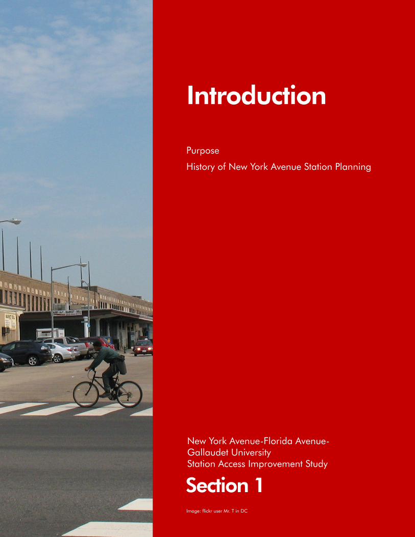
Introduction
Purpose
History of New York Avenue Station Planning
Section 1
New York Avenue-Florida Avenue- Gallaudet University Station Access Improvement Study
Image: flickr user Mr. T in DC


New York Avenue-Florida Avenue-Gallaudet University Station Access Improvement Study
The New York Avenue-Florida Avenue-Gallaudet University station1 is the first infill station2 constructed on the Metrorail system. Its addition to the Metrorail system provides the surrounding area improved access to premium public transportation. The station was not in the Adopted Regional System (ARS) plan that guided initial system development, but was added later in 2000.
Construction of the New York Avenue station achieved many first-time accomplishments, which include:
• Construction phasing between two existing, operational Red Line stations
• Using design/build to reduce the project schedule by half the typical delivery time
• Incorporating a multi-use trail that provides connections for pedestrian and bicycle usage
• Using new architectural design standards that change the look of future Metrorail stations
Introduction
The station is also the first in the Metrorail system built with combined public and private funds. Construction of the station exceeded $100 million,3 which was paid for through $54 million from the District of Columbia, $31 million from the federal government, and the $25 million from area businesses. Funding from the latter was arranged through a 30-year special assessment on commercial properties within 2,500 feet of the future station’s entrances (excluding those properties within 1,250 feet of Union Station).
When the ARS was adopted, much of the area immediately surrounding the station site consisted of railroad yards, warehouses, and other industrial uses, and there was little reason to locate a station there. Later, the station was proposed as part of an economic development strategy for the area. Planning for the New York Avenue station began in 1998, and it opened for service in November 2004. Station planning primarily focused on the station and its site, with limited attention to access.
PurposeThe purpose of the New York Avenue-Florida Avenue-Gallaudet University Metrorail Station Access Improvement Study is as follows:• Identify access needs and
deficiencies• Define ways to enhance accessibility
for pedestrians and bicyclists• Improve the pedestrian
environment• Improve the connectivity and flow
of Metrobuses, shuttle buses, and private automobiles at the station. Figure 1: New York Avenue-Florida Avenue-
Gallaudet University Station
1Section 1

New York Avenue-Florida Avenue-Gallaudet University Station Access Improvement Study
Street, extending northward from the redeveloping area around Union Station.
The Metrorail system is a vital component of the Washington region’s transportation system and it has helped to foster major development of the land around stations in other parts of the region. Building a station at New York Avenue was a central part of the redevelopment strategy because of the recognized benefits that a station can create.
The single most important characteristic of the development of the New York Avenue station was the broad-based, cooperative efforts that moved the station forward. The station had many champions including several public agencies, many community leaders and civic organizations, and private property owners supported the station and worked together to make it real.
The original impetus for station development came from the community. There had long been efforts to encourage community redevelopment both to improve the physical condition of the surrounding neighborhoods and to expand economic opportunities, including the number of jobs. Formal action began when then Mayor Anthony Williams created the New York Avenue Development Task Force to determine ways to redevelop New York Avenue into an attractive gateway into Washington. The task force included a broad cross-section of community and political leaders. In November 1996, the task force issued its New York Avenue Development Report, which addressed economic development, housing, and transportation. The report’s recommendations included a wide range of roadway, public transportation, streetscape, development, and urban design
The study examined (1) existing conditions; (2) analyzed current and future access needs; (3) reviewed potential access improvements; and (4) developed recommendations for action by Washington Metropolitan Area Transit Authority (Metro), District Department of Transportation (DDOT), North of Massachusetts Avenue Business Improvement District (NoMa BID), and potential new developers within the station area.
History of New York Avenue Station Planning When the Metrorail system was planned in the 1960s, there were few potential riders in the New York Avenue corridor because of the surrounding industrial development. As a result, the Red Line’s planners decided to bypass New York Avenue, establishing stops instead at Union Station—a major transportation terminal three-quarters of a mile south—and at Rhode Island Avenue in an established neighborhood an equal distance north. This mile-and-a-half station spacing was Metrorail’s longest in the developed portion of the region’s core.
Although the New York Avenue corridor was in need and is currently the subject of redevelopment, the area around the potential station site had many resources that would support a Metrorail station as well as complement redevelopment efforts. Established residential neighborhoods lie to both the north and south. To the east are Gallaudet University, the only liberal arts university in the world designed exclusively for deaf and hard-of-hearing students, and the Florida Avenue Market (also known as Capital City Market), a farmers’ market and wholesale food distribution center. An area of commercial office buildings lies to the south and west along North Capitol
actions. One was the construction of a new station on the Red Line.
In November 1998, the District government went on record as supporting the station with the publication of its first strategic economic development plan, The Economic Resurgence of Washington, DC. The plan included 40 key actions to implement the plan, two of which affected planning of the future station and its surrounding area. Action 26 called for the development of NoMa—North of Massachusetts Avenue—as a technology, media, housing, and arts district. Action 29 sought to build the future New York Avenue station through a public-private financing mechanism. This action was carried out by Action 29 Corporation—a consortium of the private sector, political leaders, community leaders, and environmental activists—that dissolved once the station opened for service.
April 1999 marked the release of two reports showing strong support for the feasibility and planning of the future New York Avenue station. The New York Avenue Metrorail Station Feasibility Study—produced by the non-profit organization Save New York Avenue, Inc. with funding from the District of Columbia Department of Housing and Community Development (DCDHCD)—proposed six alternative station sites, selected two sites for more-detailed analysis, and recommended one alternative. Metro’s Transit Service Expansion Plan included the addition of the New York Avenue station as part of the agency’s program of transit investments for the next 25 years.
As Metro progressed further with station implementation, it made special efforts to ensure continued public-private support for the station. Metro retained the North
2 Section 1

New York Avenue-Florida Avenue-Gallaudet University Station Access Improvement Study
Capitol Area Business Association (NCABA) to assist in involving the affected community in the planning and development of the station. NCABA was a nonprofit advocacy organization in the area of the proposed station. Because NCABA was a part of the community, it provided a direct two-way communication link with the people who would be most affected by the station.
During the time station implementation was moving closer toward design and construction, Metro was also developing a new station architectural standard, intended to be used for all future stations. The standard emphasized a lighter, more-open feel than the original station designs. The New York Avenue station was the first station to which the new standard was applied. The station canopy is steel and glass—not precast concrete—to increase the amount of natural light reaching the platform. Stainless steel was used to brighten station surfaces. A decorative screen and public art were part of the design to enhance the station’s exterior.
3Section 1


Existing Station Area Characteristics Planning Area
Existing Station Area Land Use
Station Facilities and Amenities
Existing Ridership
Transportation Network
Safety and Security
Amtrak Overpasses
Station Environment
Section 2
New York Avenue-Florida Avenue- Gallaudet University Station Access Improvement Study


New York Avenue-Florida Avenue-Gallaudet University Station Access Improvement Study
Planning AreaThe New York Avenue station is part of the Red Line Metrorail service, between Union Station heading toward Shady Grove and the Rhode Island Avenue-Brentwood station heading toward Glenmont. Union
Existing Station Area Characteristics
Station is three blocks south of the station and is located east of the intersection of New York and Florida Avenues, NE and is between M Street, NE and Florida Avenue, NE. The station is adjacent to the Amtrak Northeast Corridor railroad
Figure 2: New York Avenue Station Area
Source: Aerial image from Google Earth; roadway baseline data from DCGIS
7Section 2

New York Avenue-Florida Avenue-Gallaudet University Station Access Improvement Study
Existing Station Area Land UseThe station area has a diverse array of employment centers, activity centers, points of interest, and residential units. In terms of development, it is dominated by residential moderate-density (25.7 percent), production/technical employment (20.8 percent), commercial medium-high density (19.6 percent), and mixed use (13.6 percent) types of land uses.
tracks. Both the Red Line and the Northeast Corridor are elevated on an embankment with overpasses at Florida Avenue, NE and K, L, and M Streets, NE.
The station area encompasses a half-mile radius around each of the New York station entrances. It is loosely contained by T Street to the north; First Street, NW to the west; F Street to the south, and Eighth Street, NE/Gallaudet University to the east. The following neighborhoods surround the station area, as given by their general boundaries.4
Bloomingdale sub-division—in the Northwest quadrant of the District, generally bounded by First Street to the west, T Street to the north, North Capitol Street to the east, and Florida Avenue to the south
Eckington—in the Northeast quadrant of the District, generally bounded by Lincoln Road to the west, Rhode Island Avenue to the north, the Metrorail Red Line to the east, and Florida Avenue to the southNear Northeast (Capitol Hill North)—in the Northeast quadrant of the District, generally bounded by Second Street to the west, Florida Avenue to the north, Maryland Avenue to the east, and Massachusetts Avenue to the south
NoMa—primarily in the Northeast quadrant of the District, between Mount Vernon Square and Near Northeast: it is generally bounded by North Capitol Street to the west, Florida Avenue to the north, the Amtrak embankment to the east, and Massachusetts Avenue to the south
Sursum Corda/Northwest One—in the Northwest quadrant of the District, generally bounded by New Jersey Avenue to the west, M Street to the
north, North Capitol Street to the east, and K Street to the south
Truxton Circle—in the Northwest quadrant of the District, generally bounded by New Jersey Avenue to the west, Florida Avenue to the north, North Capitol Street to the east, and New York Avenue to the south
Figure 2 shows the station area boundary and primary neighborhoods within the station area.
Figure 3: Existing Land Uses and Neighborhoods within New York Avenue Station Area
Source: Land use data from DCOP via DC GIS
8 Section 2

New York Avenue-Florida Avenue-Gallaudet University Station Access Improvement Study
The growing NoMa neighborhood includes the Bureau of Alcohol, Tobacco, Firearms, and Explosives (ATF) headquarters; DDOT headquarters; Sirius XM Satellite Radio (formerly XM Satellite Radio) office; FedEx distribution center; Greyhound bus terminal; the new Marriott by Courtyard hotel; the historic Uline Arena; and several new developments including Constitution Square (future site of Harris Teeter supermarket and Hilton Garden Inn hotel). Two Rivers Public Charter School, J.O. Wilson Elementary School, and several long-standing churches are found in the Near Northeast neighborhood. The Eckington neighborhood contains the McKinley Technology High School. Gallaudet University and the Florida Avenue Market are in Ivy City. Medium- and moderate-density residences are found predominantly in the Near Northeast, Eckington, and Mount Vernon neighborhoods.
NoMa BID estimates over four million square feet of mixed-use development is currently under construction west of the station, and only a few vacant parcels remain. The Courtyard by Marriott hotel adjacent to the New York Avenue station recently opened in April 2009. Current development activities include the construction of the Hilton Garden Inn hotel and Harris Teeter supermarket at the future Constitution Square, which is also adjacent to the station site. Figure 3 shows the station area’s existing land uses, based on the most recent 2004 land use data from DC Office of Planning (DCOP). Figure 4 shows some of the many points of interest within the station area. Figure 5 shows the station in relation to the surrounding area.
Figure 4: Points of Interest within New York Avenue Station Area (left column: DC government offices, Courtyard by Marriott, Gallaudet University; right column: Florida Avenue Market, Two Rivers Public Charter School, the future Constitution Square)
Source: Gallaudet University and Florida Avenue Market by flickr user Mr. T in DC
Figure 5: New York Avenue Station in Relation to Surrounding Area
Source: Images of bird’s eye view from Microsoft Bing Maps
9Section 2

New York Avenue-Florida Avenue-Gallaudet University Station Access Improvement Study
Station Facilities and AmenitiesThe New York Avenue station was designed using new architectural standards developed by Metro. The new standards incorporate building materials that are less massive, are more transparent, and use lighter colors. They allow for increased natural light and artificial lighting levels, and provide greater weather protection and station entry identification. This is evidenced by the glass-enclosed pavilion at the north entrance; newer, lighter, and more open look at the south entrance; and steel and glass construction material for the station platform.
The New York Avenue station highlights several changes in the platform design. The new canopy is arched, reflecting a modern interpretation of the older gull-wing canopy design. It also incorporates recessed lights that enhance lighting levels and are easier to maintain. New overhead signage replaces previous use of pylons, thereby enhancing circulation along the platform.
Vertical circulation at the station now includes the use of multiple elevators and escalator/staircase pairings to handle the demand. The New York Avenue station has two escalator/staircase pairs for each entrance.
The New York Avenue station was planned for access primarily by foot, bicycle, and bus, thereby eliminating the need for Park & Ride and Kiss & Ride facilities. The station does not include bus bays or off-street bus loading because no Metrobuses originate or terminate at the station. Bus stops located on Florida Avenue serve this station.
The station initially had five inverted U-type bicycle racks and 28 bicycle lockers. Metro has increased the
Figure 6: Examples of Amenities and Facilities at the New York Avenue Station (left column: north entrance pavilion, south entrance, station platform; right column: south entrance bicycle racks, fare vending machines, new platform-level overhead signage)
Source: Station Platform courtesy of Wikimapia
Table 1: New York Avenue Station Facilities and Amenities
Facility/Amenity Quantity
Station Entrance North entrance: 200 Florida Avenue, NE (corner of 2nd and N Streets, NE)
South entrance: M Street, NE between 1st Street and Delaware Avenue, NE
Bicycle/Pedestrian Trail 1 (part of Metropolitan Branch Trail)
Bicycle Storage 13 inverted U-type racks; 28 lockers
Elevators 3 (2 from platform to mezzanine; 1 from Metropolitan Branch Trail to north entrance)
Escalators 4 (2 per entrance)
Staircases 4 (2 per entrance)
Fare Gates 8 (5 at north entrance; 3 at south entrance)
Fare Vending Machines 7 (4 at north entrance; 3 at south entrance)
Exit Fare Vending Machine 4 (2 per entrance)
10 Section 2
New York Avenue-Florida Avenue-Gallaudet University Station Access Improvement Study
numbers of bicycle racks at the station: as of January 2010, there are now 13 racks to facilitate and promote bicycle access to the station.
Table 1 lists the facilities and amenities at the New York Avenue station, and Figure 6 shows some of the facilities and amenities offered at the station.
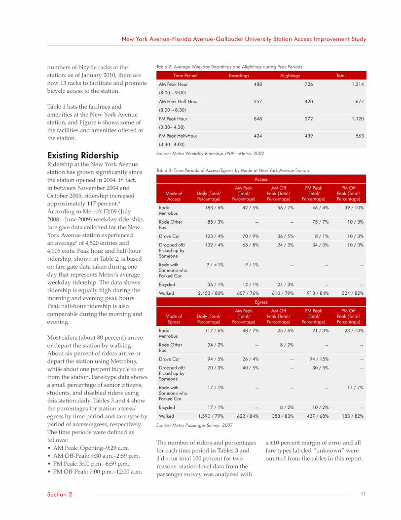
Existing RidershipRidership at the New York Avenue station has grown significantly since the station opened in 2004. In fact, in between November 2004 and October 2005, ridership increased approximately 117 percent.5 According to Metro’s FY09 (July 2008 – June 2009) weekday ridership, fare gate data collected for the New York Avenue station experienced an average6 of 4,520 entries and 4,005 exits. Peak hour and half-hour ridership, shown in Table 2, is based on fare gate data taken during one day that represents Metro’s average weekday ridership. The data shows ridership is equally high during the morning and evening peak hours. Peak half-hour ridership is also comparable during the morning and evening.
Most riders (about 80 percent) arrive or depart the station by walking. About six percent of riders arrive or depart the station using Metrobus, while about one percent bicycle to or from the station. Fare-type data shows a small percentage of senior citizens, students, and disabled riders using this station daily. Tables 3 and 4 show the percentages for station access/egress by time period and fare type by period of access/egress, respectively. The time periods were defined as follows:• AM Peak: Opening–9:29 a.m.• AM Off-Peak: 9:30 a.m.–2:59 p.m.• PM Peak: 3:00 p.m.–6:59 p.m.• PM Off-Peak: 7:00 p.m.–12:00 a.m.
Table 2: Average Weekday Boardings and Alightings during Peak Periods
Time Period Boardings Alightings Total
AM Peak Hour
(8:00 – 9:00)
488 726 1,214
AM Peak Half-Hour
(8:00 – 8:30)
257 420 677
PM Peak Hour
(3:30– 4:30)
848 272 1,120
PM Peak Half-Hour
(3:30– 4:00)
424 439 563
Source: Metro Weekday Ridership FY09—Metro, 2009
Table 3: Time Periods of Access/Egress by Mode at New York Avenue Station
Access
Mode of Access
Daily (Total/Percentage)
AM Peak (Total/
Percentage)
AM Off Peak (Total/Percentage)
PM Peak (Total/
Percentage)
PM Off Peak (Total/Percentage)
Rode Metrobus
183 / 6% 42 / 5% 56 / 7% 46 / 4% 39 / 10%
Rode Other Bus
85 / 3% -- -- 75 / 7% 10 / 3%
Drove Car 123 / 4% 70 / 9% 36 / 5% 8 / 1% 10 / 3%
Dropped off/Picked up by Someone
132 / 4% 63 / 8% 24 / 3% 34 / 3% 10 / 3%
Rode with Someone who Parked Car
9 / <1% 9 / 1% -- -- --
Bicycled 36 / 1% 12 / 1% 24 / 3% -- --
Walked 2,453 / 80% 607 / 76% 610 / 79% 913 / 84% 324 / 82%
Egress
Mode of Egress
Daily (Total/Percentage)
AM Peak (Total/
Percentage)
AM Off Peak (Total/Percentage)
PM Peak (Total/
Percentage)
PM Off Peak (Total/Percentage)
Rode Metrobus
117 / 6% 48 / 7% 25 / 6% 21 / 3% 23 / 10%
Rode Other Bus
34 / 2% -- 8 / 2% -- --
Drove Car 94 / 5% 26 / 4% -- 94 / 15% --
Dropped off/Picked up by Someone
70 / 3% 40 / 5% -- 30 / 5% --
Rode with Someone who Parked Car
17 / 1% -- -- -- 17 / 7%
Bicycled 17 / 1% -- 8 / 2% 10 / 2% --
Walked 1,590 / 79% 622 / 84% 358 / 83% 427 / 68% 183 / 82%
Source: Metro Passenger Survey, 2007
The number of riders and percentages for each time period in Tables 3 and 4 do not total 100 percent for two reasons: station-level data from the passenger survey was analyzed with
a ±10 percent margin of error and all fare types labeled “unknown” were omitted from the tables in this report.
11Section 2

New York Avenue-Florida Avenue-Gallaudet University Station Access Improvement Study
Transportation Network
Pedestrian and Bicycle
AccessPedestrians and bicycles access the New York Avenue station from either one of the two entrances. Direct access to the station is facilitated by using M Street, NE for the south entrance and N Street or Second Street, NE for the north entrance. Access to the north entrance is possible primarily because N and Second Streets were extended concurrent with the construction of the ATF headquarters. Because the Red Line is on the west side of Amtrak’s Northeast Corridor, station access is also along the west side of the tracks. The railroad embankment creates a wide physical barrier on the east, and pedestrian access from
that side is possible only along the sidewalks on Florida Avenue, NE and M Street, NE beneath the railroad overpasses.
Although the New York Avenue station has been in service for over five years, some residents and visitors to the areas are unfamiliar with its location. The station area lacks wayfinding signage to direct pedestrians to the New York Avenue station (see Figure 7). Only one such sign exists, and it is located at the corner of First and L Streets, NE (see Figure 8). NoMa BID identified the following as potential locations for wayfinding signage: • First Street and M Streets, NE• First and N Streets, NE• Third and M Streets, NE
• New York Avenue and First Street, NE
• Locations along Florida Avenue immediately east and west of the north station entrance
There is a discontinuous network of bicycle lanes, signed routes, and trails within the station area. The lanes and routes in this area do not lead to either of the station entrances directly (such as those along Fourth Street, Sixth Street, and Eckington Place, NE). Roadways that bicyclists can utilize and bring them closer to the entrances—M Street, NE; K Street, NE; and Florida Avenue, NE—rate as having either fair or poor traveling conditions for bicyclists according to the ratings listed on the District of Columbia Bicycle Map (2008). The bicycle network and traveling conditions within the station area are shown in Figure 9.
The station incorporates the Metropolitan Branch Trail, a planned eight-mile trail and linear park generally following the Red Line alignment from Union Station to Silver Spring. For continuity with the rest of the planned trail, a section of it is elevated at the station, passing along the perimeter of the Courtyard by Marriott hotel and adjacent to the southbound Metrorail tracks. A spiral staircase and an elevator near the north station entrance lead directly to
Table 4: Fare Types by Time Period of Access/Egress at New York Avenue Station
Access
Fare TypeDaily (Total/Percentage)
AM Peak (Total/
Percentage)
AM Off Peak (Total/Percentage)
PM Peak (Total/
Percentage)
PM Off Peak (Total/Percentage)
Regular 2490 / 81% 674 / 85% 604 / 78% 883 / 81% 324 / 82%
Senior 31 / 1% -- 13 / 2% 17 / 2% --
School 104 / 3% 21 / 3% 11 / 1% 28 / 3% 44 / 11%
Disabled 95 / 3% 21 / 3% 49 / 6% 25 / 2% --
Egress
Fare TypeDaily (Total/Percentage)
AM Peak (Total/
Percentage)
AM Off Peak (Total/Percentage)
PM Peak (Total/
Percentage)
PM Off Peak (Total/Percentage)
Regular 1,768 / 88% 682 / 93% 340 / 79% 558 / 89% 188 / 85%
Senior 26 / 1% -- 12 / 3% -- 14 / 6%
School -- -- -- -- --
Disabled 90 / 4% 17 / 2% 37 / 9% 15 / 2% 21 / 9%
Source: Metro Passenger Survey, 2007
Figure 7: Absence of Wayfinding Signs along Florida Avenue, NE near North Entrance
Source: Google Earth
Figure 8: Wayfinding Sign at First and L Streets, NE
Source: NoMa BID, 2008
12 Section 2

New York Avenue-Florida Avenue-Gallaudet University Station Access Improvement Study
the elevated section. The trail at the south entrance can be accessed by a ramp on the south side of M Street, NE. The trail is being built in sections as right-of-way and funding become available. An elevated section of the trail adjacent to the southbound Red Line tracks and its vertical connections are shown in Figure 10.
General Condition of Pedestrian and Bicycle FacilitiesIn 2006, DDOT published the report KLM Small-Area Traffic Study.
It detailed the existing traffic, pedestrian, and bicycle conditions along K, L, and M Streets, NE and offered recommendations for improvements. The pedestrian issues in the report focused on the following blocks:
• First Street, NE between New York Avenue and M Street, NE
• First Street, NE and Second Street/Delaware Avenue between M Street and K Street, NE
• M Street, NE between Delaware Avenue and Fourth Street, NE
• Third Street, NE between Florida Avenue and M Street, NE
• M Street, NE between Fourth Street and Sixth Street, NE
The report noted that there were many worn or missing crosswalks within these blocks and that the sidewalks were of varying conditions. Many appeared to terminate with curb ramps having detectable warning devices; however, there were segments of discontinuous or missing sidewalks. Some sidewalks were uneven and broken, had differing
Figure 9: Bicycle Facilities and Roadway Conditions in New York Avenue Station Area
Source: DC Bicycle Map—DDOT, 2008
Figure 10: Bicycle Facilities adjacent to and near New York Avenue Station (source: elevated section of Metropolitan Branch Trail [facing north], adjacent to southbound tracks, bicycle lane on Fourth Street, NE [facing north], bicycle lanes on Eckington Place, NE [facing north])
13Section 2

New York Avenue-Florida Avenue-Gallaudet University Station Access Improvement Study
widths within the same block, lacked pedestrian buffers, or were closed due to construction. The conditions in some locations—particularly along Second Street/Delaware Avenue, NE and the 100 block of L Street, NE—have either been addressed by DDOT or should be addressed as part of construction happening for some developments.
The report contains data on pedestrian volumes counted at intersections within the vicinity of the New York Avenue station. As shown in Figure 11, over 200 pedestrians traverse the intersection of M and First Streets, NE (which is one block west of the station entrance) during the AM peak period and fewer than 200 pedestrians traverse the same intersection during the PM peak period. By comparison, the intersections of Florida Avenue, NE and Third Street, NE and M and Third Streets, NE have less pedestrian traffic, ranging between 50 and 130 pedestrians during any given peak period.
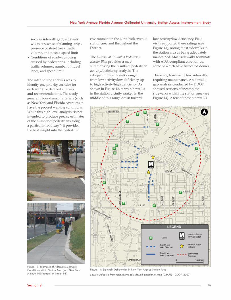
In 2008, DDOT released the draft version of the District of Columbia Pedestrian Master Plan. The primary goals of the plan are to provide recommendations that will lead to reduced pedestrian injuries and fatalities, as well as help foster more walkable and accessible pedestrian facilities throughout the District. As part of the study, DDOT performed high-level analysis to determine sidewalks with the high potential for pedestrian activity, yet poor walking conditions. The follow criteria were used to perform the analysis:
• Proximity of pedestrian activities to roadway segments
• Population and employment density
• Assessment of walking environment, considering factors Figure 12: High Pedestrian Activity/Deficiency Roadways
Source: High Activity/High Deficiency Map7—DDOT, 2007
Figure 11: Pedestrian Volumes by Intersection
Source: Adapted from KLM Small-Area Traffic Study—DDOT, 2006
14 Section 2
New York Avenue-Florida Avenue-Gallaudet University Station Access Improvement Study
such as sidewalk gap8, sidewalk width, presence of planting strips, presence of street trees, traffic volume, and posted speed limit
• Conditions of roadways being crossed by pedestrians, including traffic volumes, number of travel lanes, and speed limit
The intent of the analysis was to identify one priority corridor for each ward for detailed analysis and recommendations. The study generally found major arterials (such as New York and Florida Avenues) to have the poorest walking conditions. While this high-level analysis “is not intended to produce precise estimates of the number of pedestrians along a particular roadway,”9 it provides the best insight into the pedestrian
environment in the New York Avenue station area and throughout the District.
The District of Columbia Pedestrian Master Plan provides a map summarizing the results of pedestrian activity/deficiency analysis. The ratings for the sidewalks ranged from low activity/low deficiency up to high activity/high deficiency. As shown in Figure 12, many sidewalks in the station vicinity ranked in the middle of this range down toward
low activity/low deficiency. Field visits supported these ratings (see Figure 13), noting most sidewalks in the station area as being adequately maintained. Most sidewalks terminate with ADA-compliant curb ramps, some of which have truncated domes.
There are, however, a few sidewalks requiring maintenance. A sidewalk gap analysis conducted by DDOT showed sections of incomplete sidewalks within the station area (see Figure 14). A few of these sidewalks
Figure 13: Examples of Adequate Sidewalk Conditions within Station Area (top: New York Avenue, NE; bottom: M Street, NE)
Figure 14: Sidewalk Deficiencies in New York Avenue Station Area
Source: Adapted from Neighborhood Sidewalk Deficiency Map (DRAFT)—DDOT, 2007
15Section 2

New York Avenue-Florida Avenue-Gallaudet University Station Access Improvement Study
either have been or will be repaired or completed, with funding from the street improvement project. Any remaining deficient sidewalks may not be programmed for immediate funding. DDOT’s local street, alley, and sidewalk schedules for FY08 and FY09 did not include any sidewalks within the station area.
Many signalized intersections also function with paired pedestrian signals. Most intersections in the station area (particularly those in the southeast section) are striped with either standard or high-
visibility crosswalks. However, some crosswalks are worn and require maintenance, while a few intersections have curb ramps with no corresponding crosswalks. Figure 15 shows examples of crosswalk conditions in the New York Avenue station area.
A field visit to the station area confirmed some of the described sidewalk conditions showing pockets of cracked or discontinuous sidewalks. These deficiencies affect, in particular, disabled pedestrians who use the station. The existing
layout of some sidewalks within the station area also impedes pedestrian movement. For example, the south side of Florida Avenue, NE between Fourth and Eighth Streets and the west side of Sixth Street, NE between Florida Avenue, NE and M Street, NE both have narrow sidewalks with lamp posts in the middle of them. These narrow sidewalks reflect the history of the area surrounding the New York Avenue station as one that contained many industrial land uses. As such, they do not support the pedestrian volumes resulting from the station and growing development in the area; they also do not meet ADA compliance. Additionally, a curb ramp at Second Street and Florida Avenue, NE and trench drain in front of the Courtyard by Marriott entrance—both installed during construction of the hotel—have grade changes that present possible safety hazards for visually and hearing-impaired10 pedestrians because of lack of detectable warning devices. Figure 16 shows examples of deficient and hazardous sidewalk conditions in the station area.
The sidewalk conditions along Florida Avenue prompted community interest—especially the deaf and hard-of-hearing community—in Metro considering an entrance near N and Third Streets, NE. Metro investigated this option during the original planning of the New York Avenue station and this station access study. Both investigations showed construction of a new east entrance to be cost-prohibitive. Safety concerns of providing an east tunnel access and prolonged service disruptions during all operating hours of the Red Line were additional factors in determining that this option should not be advanced. While the sidewalks beneath the Amtrak overpass at Florida Avenue currently present an unfriendly pedestrian environment,
Figure 16: Examples of Deficient and Hazardous Sidewalk Conditions within Station Area (Clockwise from top left: Sixth Street NE, Third Street NE, grade change in sidewalk for trench drain, Patterson Street NE)
Figure 15: Examples of Crosswalk Conditions within Station Area (left: Visible and well-marked crosswalk across from M Street, NE entrance; right: Worn crosswalk at corner of Patterson and First Streets, NE)
16 Section 2

New York Avenue-Florida Avenue-Gallaudet University Station Access Improvement Study
there are opportunities to improve the environment that should be explored and promoted.
DDOT’s recently updated engineering and design standards and new pedestrian master plan both call for sidewalks that are at least six feet wide or require other acceptable measures that accommodate all pedestrians. This is especially critical where passengers are waiting for buses along Florida Avenue, NE, or where young or hearing- and visually impaired pedestrians are walking to Gallaudet University or nearby secondary schools.
The KLM Small-Area Traffic Study made several recommendations addressing sidewalk, crosswalk, and pedestrian signal improvements. DDOT has implemented many of those recommendations, in addition to making improvements along Florida Avenue, NE at the overpass. The project includes repaving streets and sidewalks; upgrading safety characteristics; improving drainage, lighting, striping, signs, and signals; and adding landscaping.
As part of DDOT’s project to rehabilitate streets at the overpasses, sidewalks on L and M Streets, NE were widened from 12 feet to nearly
30 feet (see cross-section of M Street, NE in Figure 17). This was done by reducing the street widths from four to two lanes. Sidewalks were repaved and Washington globe streetlights were added beneath the overpasses. The sidewalks on Florida Avenue, NE were repaved but not widened; they are less than six feet wide beneath the overpass with no buffers from traffic. DDOT is currently evaluating the transportation and safety impacts of a widened sidewalk along Florida Avenue, NE.
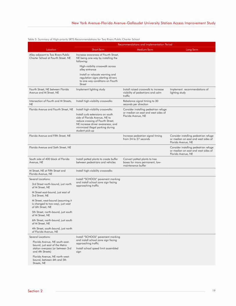
In spring 2009, DDOT repaired the sidewalk on the north side of the 300 block of M Street, NE and a section of the east side of the 1200 block of Fourth Street, NE with brick pavers (Figure 18). The work was done as part of the Safe Routes to School (SRTS) study conducted during the 2008-2009 school year for Two Rivers Public Charter School, which is located two blocks east of the station’s north entrance. The study was part of DDOT’s SRTS pilot program and focused on working with the school on planning recommendations to be implemented through either a separate funding mechanism or other planning/engineering studies in the area. The study conducted for Figure 17: Sidewalk Widening along M Street, NE beneath Amtrak Overpass
Figure 18: Repaved Sidewalks within New York Avenue Station Area (left: North side of 300 block of M Street, NE; right: East side of 1200 block of Fourth Street, NE)
17Section 2

New York Avenue-Florida Avenue-Gallaudet University Station Access Improvement Study
Two Rivers Public Charter School is still in a draft stage and needs to ensure its recommendations also reflect the needs of the surrounding community. Numerous short- (within two years), medium- (within five years), and long-term (longer than five years) recommendations were developed to enhance the pedestrian environment for the school’s students. The high-priority recommendations are summarized in Table 5 on the next page.
Additionally, DDOT will be able to construct a sidewalk along Third Street, NE using American Recovery and Reinvestment Act (ARRA) funds.
In an effort to address safety issues in the station area, DDOT began construction on a “virtual traffic circle” at the intersection of New York and Florida Avenues in fall 2009 to
alleviate traffic problems. Scheduled for completion in June 2010, the reconstruction will not only provide for improved automobile safety through this complex intersection. It will also add significant bicycle and pedestrian safety elements to the intersection, including pedestrian signal retiming. NoMa BID received a grant from MWCOG in spring 2009 allowing it to develop recommended pedestrian safety and beautification improvements to the reconstructed intersection. It also received $200,000 in transportation enhancement funds to implement some of those recommendations. NoMa BID staff is working with DDOT to incorporate some of those recommendations into the construction project, which will be completed in June 2010. Figure 19 shows the conceptual design of the intersection.
Transit ServiceMetro provides bus service to the New York Avenue station by way of the 90, 92, 93, and X3 Metrobus routes—all of which operate on Florida Avenue. The following bus stops are located closest to the station:
• Florida Avenue, NE, directly opposite the southeast corner of Third Street, NE for westbound buses
• Florida Avenue, NE, at the southeast corner of Second Street, NE for eastbound buses
The westbound bus stop is located between the Burger King driveways. Pedestrians sometimes jaywalk across Florida Avenue, NE from Second Street, NE to the westbound bus stop. Metro recently reinstated the eastbound bus stop at the southeast corner of Second Street, NE and
Figure 19: Conceptual Design of New York/Florida Avenue Intersection
Source: New York Avenue Corridor Study—DDOT, DCOP, DCDHCD, 2006
18 Section 2
New York Avenue-Florida Avenue-Gallaudet University Station Access Improvement Study
Table 5: Summary of High-priority SRTS Recommendations for Two Rivers Public Charter School
Recommendations and Implementation Period
Location Short-Term Medium-Term Long-Term
Alley adjacent to Two Rivers Public Charter School at Fourth Street, NE
Increase awareness of Fourth Street, NE being one-way by installing the following:
High-visibility crosswalk across alley entrance
Install or relocate warning and regulation signs alerting drivers to one-way conditions on Fourth Street
Fourth Street, NE between Florida Avenue and M Street, NE
Implement lighting study Install raised crosswalk to increase visibility of pedestrians and calm traffic
Implement recommendations of lighting study
Intersection of Fourth and M Streets, NE
Install high-visibility crosswalks Rebalance signal timing to 30 seconds per direction
Florida Avenue and Fourth Street, NE Install high-visibility crosswalks
Install curb extensions on south side of Florida Avenue, NE to reduce crossing of Fourth Street, NE increase driver awareness, and minimized illegal parking during student pick-up
Consider installing pedestrian refuge or median on east and west sides of Florida Avenue, NE
Florida Avenue and Fifth Street, NE Increase pedestrian signal timing from 24 to 27 seconds
Consider installing pedestrian refuge or median on east and west sides of Florida Avenue, NE
Florida Avenue and Sixth Street, NE Consider installing pedestrian refuge or median on east and west sides of Florida Avenue, NE
South side of 400 block of Florida Avenue, NE
Install potted plants to create buffer between pedestrians and vehicles
Convert potted plants to tree boxes for more permanent, low-maintenance buffer
M Street, NE at Fifth Street and Florida Avenue, NE
Install high-visibility crosswalks
Several Locations:
3rd Street north-bound, just north of M Street, NE
M Street east-bound, just east of 3rd Street, NE
M Street, west-bound (assuming it is changed to two-way), just west of 6th Street, NE
5th Street, north-bound, just south of M Street, NE
6th Street, north-bound, just south of M Street, NE
4th Street, south-bound, just north of Florida Avenue, NE
Install “SCHOOL” pavement marking and install school zone sign facing approaching traffic
Several Locations:
Florida Avenue, NE south-east-bound, just east of the Metro station overpass (or between 3rd and 4th Streets)
Florida Avenue, NE north-west-bound, between 6th and 5th Streets, NE
Install “SCHOOL” pavement marking and install school zone sign facing approaching traffic
Install school speed limit assembled sign
19Section 2

New York Avenue-Florida Avenue-Gallaudet University Station Access Improvement Study
Florida Avenue, NE upon completion of the Courtyard by Marriott hotel.
Other nearby bus routes that do not access the New York Avenue station directly are the P6, 80, 96, D1, D3, and D4. These routes provide direct access to nearby Union Station and Rhode Island Avenue-Brentwood Metrorail stations. The New York Avenue station may be considered an alternate station for those riders.
Figure 20 shows the bus routes and stops within the station area.
Roadways and Vehicle Access
RoadwaysThe roadways close to the station have different functional classifications. Urban roadways are typically classified under four system types: principal arterials, minor arterials, collectors, and local streets. Arterials provide roadway users
increased mobility, while local streets facilitate access to land uses (see Figure 21).
Florida Avenue, NE a principal arterial adjacent to the north entrance, carries high traffic volumes. New York Avenue, NE and North Capitol Street are other principle arterials within the station area. According to DDOT’s 2008 traffic volumes map, each roadway carries from 20,000 to greater than 80,000 vehicles every weekday. Other roadways within the vicinity are a combination of minor arterials (K Street, NE; Sixth Street, NE north of Florida Avenue, NE; Lincoln Road, NE; and Q Street, NE west of North Capitol Street), collectors (several roadways, including M Street, NE, First Street, NE, L Street, NE and Eckington Place, NE), and local streets (all remaining roadways). Figure 22 shows a map with these roadways.
DDOT’s KLM Small-Area Traffic Study depicts the approach volumes of intersection close to the New York Avenue station. As shown in Figure 23, the intersection of Florida Avenue,
Figure 20: Bus Routes and Stops in Vicinity of New York Avenue Station
Source: Metro Metrobus line maps
Figure 21: Relationship of Functional Classifications in Serving Mobility and Land Access
Source: Adapted from Geometric Design of Highways and Streets, 2004
20 Section 2

New York Avenue-Florida Avenue-Gallaudet University Station Access Improvement Study
NE and Third Street, NE has the highest vehicle approach volume for both the AM and PM peak hours. M Street, NE at the intersections of First and Third Streets—both closest to the south station entrance—display relatively lower approach volumes.
The traffic study also determined the level of service (LOS) for the roadways under study, as shown in Figure 24 on the next page. Compared to other intersections, Locations 1 (M and First Streets, NE) and 2 (M Street and Delaware Avenue, NE) were shown to have high levels of service for vehicles.
AccessVehicles arriving at the New York Avenue station typically use M Street, NE as it facilitates direct access to an entrance. The construction of the ATF headquarters resulted in the reconstruction of Second and N Streets, NE at the north entrance. However, more vehicles tend to use the south entrance than the north entrance for passenger drop-offs and pick-ups.
Nearby institutions and employers, such as Gallaudet University and XM Satellite Radio, provide shuttle service to/from the New York Avenue station. These shuttles drop off and pick up station users on the north side of M Street, NE across from Delaware Avenue, NE (a short street between L and M Streets, NE that turns into Second Street, NE south of L Street, NE).
The Greyhound bus terminal is one block south of the south entrance. The New York Avenue station is a shorter walk from the intercity bus terminal than the Union Station Metrorail station.
Figure 22: Roadways and Functional Classifications within Station Area
Source: Metro Metrobus line maps
Figure 23: Vehicle Approach Volumes by Intersection (2005)
Source: KLM Small-Area Traffic Study—DDOT, 2006
21Section 2

New York Avenue-Florida Avenue-Gallaudet University Station Access Improvement Study
Safety and SecuritySafety and security reflect not only real concerns such as actual crimes that have taken place. They also include the condition of the surrounding environment that can contribute to perceived concerns, such as poor lighting or dangerous intersections.
Perceptions of high crime rates in the station vicinity reduce people’s comfort and willingness to walk to and from the station. Metropolitan Police Department (MPD) records provide information on crime in the area. Property crimes—burglary, theft, theft of items from within an automobile, stolen automobiles, and arson—comprise the largest percentage of crimes committed, with the majority of property crimes being theft from auto. Although there were fewer violent crimes—homicide, sexual abuse, robbery excluding a gun, robbery with a gun, assault with a deadly weapon excluding a gun, and assault with a deadly weapon with a gun—these crimes still were over one-quarter the total crime for the area. The total number of crimes dropped 14 percent between 2007 and 2009. There was also a 17 percent decrease in violent crime within the same period. However, there were increases in robberies without a gun and assault with a deadly weapon using a gun. Table 6 provides a list of annual crime within 1,500 feet11 of the New York Avenue station during 2007–2009.
Roadway conditions—travel speeds combined with narrow sidewalks–along Florida Avenue, NE between Fourth and Eighth Streets, NE have created hazards for those walking along or crossing Florida Avenue. A study commissioned by DDOT on travel speeds along various District corridors—DC Speed Study (2006)—gives insight into these hazardous
Figure 24: Roadway LOS
Source: Adapted from KLM Small-Area Traffic Study—DDOT, 2006
Table 6: Crime Statistics within New York Avenue Station Area (1,500-Foot Radius), 2007–2009
Crime TypeAugust 2007-
July 2008August 2008-
July 2009 Percent Change
Homicide 3 0 (100)
Sex Abuse 3 1 (67)
Robbery Excluding Gun 21 31 48
Robbery with Gun 20 19 (5)
Assault w/ Deadly Weapon Excluding Gun
18 10 (44)
Assault w/ Deadly Weapon, Gun 1 3 200
Total Violent Crime 66 64 (3)
Burglary 30 12 (60)
Theft 43 45 5
Theft from Auto 83 75 (10)
Stolen Auto 42 26 (38)
Arson 1 0 (100)
Total Property Crime 199 158 (21)
Total Crime 265 222 (16)
Source: Metropolitan Police Department Crime Map Web Site, 2009
22 Section 2

New York Avenue-Florida Avenue-Gallaudet University Station Access Improvement Study
conditions. Between August 2005 and July 2006, the average and 85th percentile speeds along Florida Avenue, NE between North Capitol and M Streets, NE reached 33 mph and 38 mph, respectively. The posted speed limit is 25 mph.
There is a speed camera in the 600 block of Florida Avenue, NE, a flashing warning light, and several warning signs to alert drivers to pedestrians crossing at unsignalized intersections. In spite of efforts to increase driver awareness, a hazardous pedestrian environment persists.
Some community input indicated that locations near the New York Avenue station have low levels of street lighting that can make some pedestrians feel wary about using the station at night. These locations include the overpass at Florida Avenue and L and M Streets, NE; Fourth and L Streets, NE; east along M Street, NE; and along Sixth Street, NE within the station area.
Few activities occurring after typical business hours and the limited presence of station managers in the evening has had a negative impact on people’s perceptions of safety at and around to the station. Some community members have indicated a combination of the lack of pedestrians and the presence of boisterous and homeless people in the station area during the evening can influence the use of the station late at night.
NoMa BID staff is working actively with MPD, Metro Transit Police, and Federal Protective Service to address public safety efforts. It has also hired ambassadors who provide information and additional presence within its boundaries; they work from 7:00 a.m. to 7:00 p.m. As more development occurs in the NoMa
neighborhood, there will be increased activity on the streets that should help increase safety—real and perceived—within the New York Avenue station area.
In the past several years, DDOT implemented several construction projects within the station area benefitting pedestrians and their safety. The agency reports the status of many completed or current construction projects through an interactive map.12 Improvements in the NoMa area include a section of the Eckington neighborhood, Orleans Place, NE and K Street, NE having received updated streetlights as recently as October 2006. DDOT also updated lighting on streets immediately adjacent to the Metrorail station, including along North Capitol Street and L and M Streets, NE. Additionally, DDOT’s street improvement project included installing Washington globe streetlights. The District government recently allocated $5 million to DDOT to make traffic and pedestrian improvements to enhance access near the north end of First Street, NE at New York Avenue. The Safe Routes to School study recently conducted for Two Rivers Public Charter School will deliver recommendations for traffic and pedestrian issues that can benefit its students as well as the adjacent community.
Amtrak OverpassesThere are four overpasses within the station area, located at Florida Avenue, NE and K, L, and M Streets, NE. Metro and Amtrak share ownership and maintenance of these overpasses. Metro has rehabilitated the portion of the overpasses supporting the Metrorail Red Line. Steel beams were repainted and holes in the concrete were patched. DDOT also provided resources to improve the aesthetics of the overpasses: it
widened the sidewalks beneath the overpasses at L and M Streets, NE and constructed trench drains to collect water weeping from the overpass abutments. Amtrak’s portion of the overpasses needs repairs to address weeping through the overpass abutments and maintain structural integrity. Areas with profound cracking and weeping beneath the overpasses are outlined with spray paint. Examples of the overpass conditions are shown in Figure 25 on the following page.
In October 2008, a walking tour was conducted with staff from Congresswoman Eleanor Holmes Norton’s office, Metro, NoMa BID, Amtrak, DDOT, DCOP, and the DC Commission on the Arts and Humanities (DCCAH) to examine the conditions of the overpasses. The meeting was an effort to show the impact of the disrepair on Amtrak’s portion of the overpasses on accessing the New York Avenue station. Amtrak representatives have agreed to some repairs, including remediating or encapsulating the lead paint and repairing areas of fallen concrete. NoMa BID will continue its communications with Amtrak on the remaining repairs needed beneath the overpasses.
Station EnvironmentThe new architecture standards also promote more station art that is incorporated into the design process. DCCAH commissioned the “Journeys”13 artwork that greets riders as they enter the New York Avenue station’s north entrance. The sculpted railing enclosing the station is also part of the “Journeys” artwork (see Figure 26).
NoMa BID is interested in incorporating additional artwork at the station and working with the DC Arts and Humanities Commission
23Section 2

New York Avenue-Florida Avenue-Gallaudet University Station Access Improvement Study
to add artwork to the areas beneath the overpasses. MRP Realty donated $50,000 to provide artwork for the Florida Avenue overpass.14 This donation, together with a $50,000 matching grant from DCCAH to fund public art15 and potential funding from Metro’s Art in Transit Program, will further enhance the travel experience for riders using the New York Avenue station.
There are few trees nearby, and more foliage can help enliven the area
and provide shade on hot days as developers construct their projects within the immediate station area. Some locations lacking foliage include M Street, NE between the overpass and Fourth Street and Sixth Street, NE between Florida Avenue and K Street, NE.
DDOT’s Urban Forestry Administration (UFA) scheduled tree plantings within the station area during the 2008-2009 fiscal year.16 A few locations included the 500 block
of M Street, NE and the 1000 and 1100 blocks of Fourth Street, NE. Many streets within the station area have mature trees with large canopies. Trees have also been planted along Second Street, NE between N Street, NE and Florida Avenue, NE; they will mature over the years to provide shade for pedestrians. UFA can continue planting trees within the station area in future planting seasons, with priorities going to requests from stakeholders committing to their care. Figure 27 shows examples of recent tree plantings within the station area.
In addition, an agreement between a recent NoMa tenant, National Public Radio (NPR), and the District government will allow for additional funding to go toward improved streetscaping between the One NoMa Station building and the station.
In August 2008, NoMa BID announced it had received a grant through the Keep America Beautiful Cigarette Litter Prevention Program to help reduce cigarette butt litter in a small area bounded by North Capitol Street; First Street, NE; K Street, NE; and G Place, NE. Using the grant money it was able to install litter cans and ash trays with holes for water drainage and to distribute “pocket ash trays.” Additionally, Metro installed new cigarette columns to replace some damaged ashtrays at the New York Avenue station.
Finally, there have been issues with employees parking beneath the Metropolitan Branch Trail along the station’s gate. Metro has an easement in that area between the north and south entrances to facilitate its daily operations at the station. Station managers have been instructed to advise employees to use parking facilities near the station.
Figure 25: Examples of Conditions beneath Amtrak Overpasses (clockwise from top left: reconstruction performed by DDOT are Florida Avenue NE overpass; trench drains along sidewalk at Florida Avenue NE overpass; water seepage beneath L Street NE overpass; wall separation beneath K Street NE overpass)
Source: bottom images from Survey of Overpasses Conditions—DCOP
Figure 26: “Journeys” and “Journeys I” Artwork at New York Avenue Station (left: Oak leaf sculpture and “Journeys” poem at north entrance; right: “Journeys I” poem by Dolores Kendrick
24 Section 2

New York Avenue-Florida Avenue-Gallaudet University Station Access Improvement Study
Figure 27: New Tree Plantings within Station Area (left: East side of Second Street NE between Florida Avenue and N Street NE; right: South side of 500 block of M Street NE
25Section 2

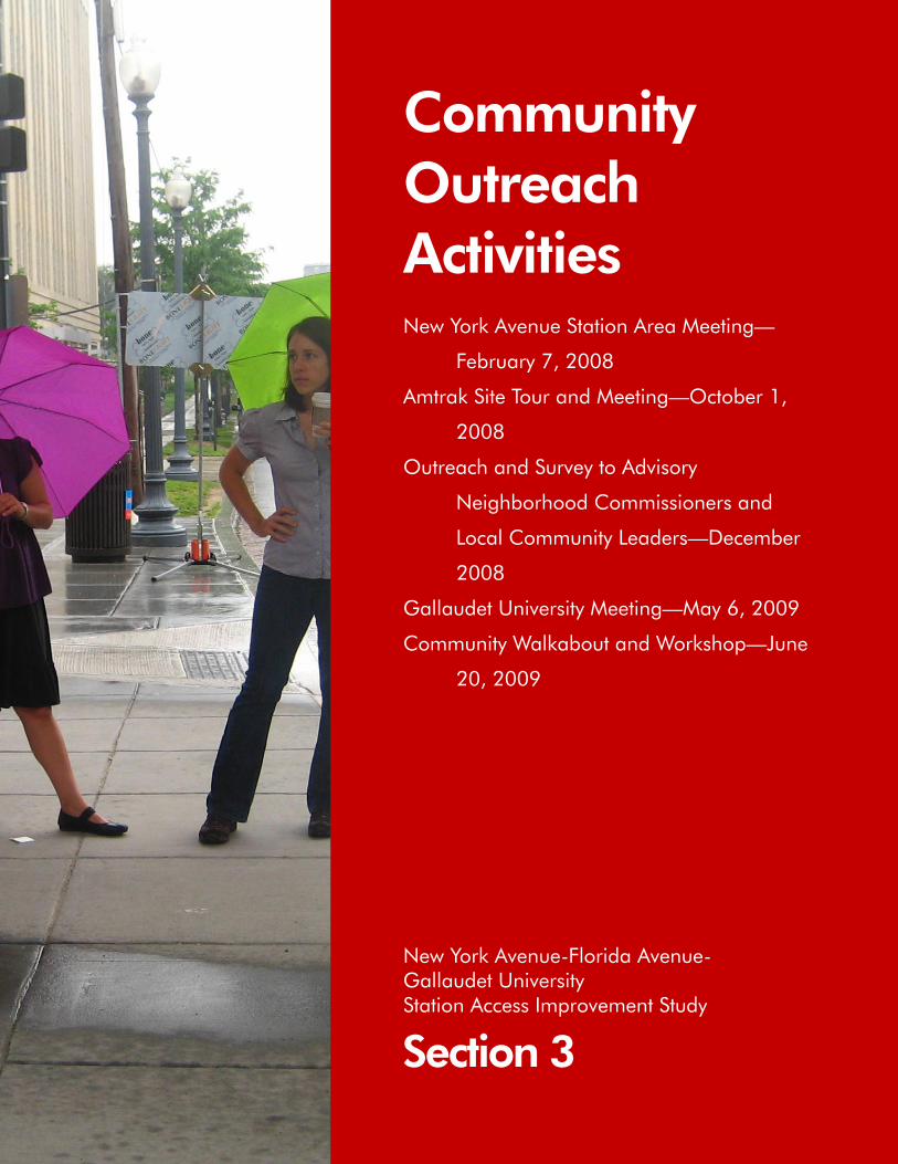
Community Outreach Activities New York Avenue Station Area Meeting—
February 7, 2008
Amtrak Site Tour and Meeting—October 1,
2008
Outreach and Survey to Advisory
Neighborhood Commissioners and
Local Community Leaders—December
2008
Gallaudet University Meeting—May 6, 2009
Community Walkabout and Workshop—June
20, 2009
Section 3
New York Avenue-Florida Avenue- Gallaudet University Station Access Improvement Study


New York Avenue-Florida Avenue-Gallaudet University Station Access Improvement Study
The study was developed using broad and active community engagement practices. Community engagement, a means of involving the public in the planning process, was one of the most critical components of fulfilling the study’s mission. This component included assessing the New York Avenue station area conditions, identifying station area deficiencies and needs, soliciting public comments and ultimately taking the findings to the broader public and validating “what we heard.” Through the involvement of community stakeholders, there was a conscious effort to identify the station area needs of all community stakeholders and incorporate their input into the recommendations for improving station access in the future.
Engaging stakeholders helped describe the New York Avenue station experience. Community stakeholders consisted of representatives from NoMa BID, Gallaudet University faculty and students, District government agencies (primarily DDOT and DCOP), local advisory neighborhood commissioners (ANCs), numerous community organizations, neighborhood associations, local businesses, residents, and representatives from federal government and Amtrak. District government stakeholders provided valuable background information on various infrastructure (sidewalk, multiuse trail, and roadway) improvements, development activities, transportation studies, and public facilities. Engaging stakeholders helped describe the Metro experience from the transit user’s perspective by
Community Outreach Activities
identifying observed deficiencies and assets. Generally, such observations were (1) during departures from and arrivals to the station, (2) while accessing to the station using trail, road, and sidewalk conditions, (3) at Metrobus stops, and (4) while using station amenities such as bicycle racks and lockers, fare gate, elevators, and the platform.
Equally as important as engaging community stakeholders during the planning process was the opportunity for Metro to forge collaborative relationships with neighboring institutions, businesses, local government, and NoMa BID in resolving station access challenges within the area. Metro has taken great strides in building relationships with its neighbors. It was not only important to hear the concerns about station access from those who are affected by it directly, but also to validate the community stakeholders information that later formed the basis of the study’s recommendations.
Metro’s planning team used various communication tools to effectively solicit, inform, and encourage stakeholder participation. The team worked closely with community stakeholders during meetings, interviews, site tours, and community workshops. This open and inclusive public participation process consisted of numerous meetings between July 2007 and August 2009. Additionally, to communicate effectively with community stakeholders, the project team used surveys, email, mass mailings, and posted banners at the New York Avenue station entrance. Key stakeholder meetings and notable
29Section 3
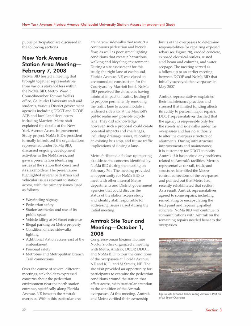
New York Avenue-Florida Avenue-Gallaudet University Station Access Improvement Study
public participation are discussed in the following sections.
New York Avenue Station Area Meeting—February 7, 2008NoMa BID hosted a meeting that brought together representatives from various stakeholders within the NoMa BID, Metro, Ward 5 Councilmember Tommy Wells’s office, Gallaudet University staff and students, various District government agencies including DDOT and DCOP, ATF, and local land developers including Marriott. Metro staff explained the details of the New York Avenue Access Improvement Study project. NoMa BID’s president formally introduced the organizations represented under NoMa BID, discussed ongoing development activities in the NoMa area, and gave a presentation identifying issues at the station that concerned its stakeholders. The presentation highlighted several pedestrian and vehicular issues relevant to station access, with the primary issues listed as follows:
• Wayfinding signage• Pedestrian safety• Station aesthetics and use of its
public space• Vehicle idling at M Street entrance• Illegal parking on Metro property• Condition of area sidewalks
lighting• Additional station access east of the
embankment• Personal safety• Metrobus and Metropolitan Branch
Trail connections
Over the course of several different meetings, stakeholders expressed concerns about the pedestrian environment near the north station entrance, specifically along Florida Avenue, NE beneath the Amtrak overpass. Within this particular area
limits of the overpasses to determine responsibilities for repairing exposed rebar (see Figure 28), eroded concrete, exposed electrical outlets, rusted steel beam and columns, and water seepage. The meeting served as a follow-up to an earlier meeting between DCOP and NoMa BID that initially surveyed the overpasses in May 2007.
Amtrak representatives explained their maintenance practices and stressed that limited funding affects its ability to perform major repairs. DDOT representatives clarified that the agency is responsible only for the streets and sidewalks under the overpasses and has no authority to alter the overpass structure or abutments. During infrastructure improvements and maintenance, it is customary for DDOT to notify Amtrak if it has noticed any problems related to Amtrak’s facilities. Metro’s representative for rail, track, and structures identified the Metro-controlled sections of the overpasses and pointed out that Metro had recently rehabilitated that section. As a result, Amtrak representatives agreed to some repairs, including remediating or encapsulating the lead paint and repairing spalled concrete. NoMa BID will continue its communications with Amtrak on the remaining repairs needed beneath the overpasses.
are narrow sidewalks that restrict a continuous pedestrian and bicycle flow, as well as poor street lighting conditions that create a hazardous walking and bicycling environment. During a site assessment for this study, the right lane of eastbound Florida Avenue, NE was closed to accommodate construction for the Courtyard by Marriott hotel. NoMa BID perceived the closure as having minimal impact on traffic, leading it to propose permanently removing the traffic lane to accommodate a widened sidewalk at the Marriott’s public realm and possible bicycle lane. They did acknowledge, however, such a proposal could create potential impacts and challenges, including drainage issues, relocating an existing bus stop, and future traffic implications of closing a lane.
Metro facilitated a follow-up meeting to address the concerns identified by NoMa BID during the meeting on February 7th. The meeting provided an opportunity for NoMa BID to meet with other internal Metro departments and District government agencies that could discuss the status of the station access study and identify staff responsible for addressing issues raised during the initial meeting.
Amtrak Site Tour and Meeting—October 1, 2008Congresswoman Eleanor Holmes Norton’s office organized a meeting with Metro, Amtrak, DCOP, DDOT, and NoMa BID to tour the conditions of the overpasses at Florida Avenue, NE and K, L, and M Streets, NE. The site visit provided an opportunity for participants to examine the pedestrian conditions around the station that affect access, with particular attention to the condition of the Amtrak overpasses. At this meeting, Amtrak and Metro verified their ownership
Figure 28: Exposed Rebar along Amtrak’s Portion of M Street Overpass
30 Section 3

New York Avenue-Florida Avenue-Gallaudet University Station Access Improvement Study
Outreach and Survey to Advisory Neighborhood Commissioners and Local Community Leaders—December 2008Working through ANCs, neighborhood association leaders, residents, and Metrorail riders, Metro distributed a brief survey to solicit feedback on the types of experiences people were having using the New York Avenue station since its opening. Metro also scheduled informal interviews and meetings with stakeholders to solicit additional feedback they may have received from constituents. A staff member from Councilman Tommy Wells’s office (who is also an ANC member in Ward 6) and a representative of the Capitol Hill North Neighborhood Association responded to interview and meeting requests and shared their constituents’ feedback gathered from an emailed distribution of the survey questions. The survey consisted of the following four questions:17
1. What kind of experience do you have when using the New York Avenue station (i.e., walking from home, work, bus, along sidewalks, etc.)?
2. Do you use the New York Avenue station for your transit needs? If not, explain your reason(s).
3. Do you feel more needs to be done to enhance the experience of arriving to or departing from the New York Avenue station, as well as the connections between the station and residential, commercial, or employment areas?
4. Are there additional issues Metro should be aware of within the station area and relevant to getting to the New York Avenue station?
Answers received from these questions were combined with
feedback received during the community walkabout and workshop held in June 2009 and they are summarized in Appendix 1.
Gallaudet University Meeting—May 6, 2009Metro met with the executive director of program development, directors of equal opportunity programs and campus planning and design, and student representatives of Gallaudet University to learn the needs of the deaf and hard-of-hearing community traveling to and from the New York Avenue station. Given the proximity of Gallaudet University to the station and the relatively larger concentration of deaf and hard-of-hearing patrons within the station area, the study consciously considered factors that would enhance pedestrian access to the station.
The meeting provided Metro with critical insights. The majority of off-campus students live in the Capitol Hill North area, while some others live in the Trinidad neighborhood. Additionally, students tend to use Metrobus routes operating along K Street, NE to access their destinations more directly.
Gallaudet University staff discussed potential developments plans—driven by the passing of the New Town Legislation in 2006 and development of a small area market study—for its vacant land at the Florida Avenue Market. The future development would lead to increased pedestrian activities east of the station. They encouraged Metro not only to consider the growth occurring west of the New York Avenue station, but also to account for future growth east of the station in its recommendations to improve station access.
Finally, Gallaudet University staff explained the Deaf Space program,
which explores the needs of deaf people and produces architectural design standards and guidelines inclusive of the needs of the deaf and hard-of-hearing community.
Community Walkabout and Workshop—June 20, 2009As part of the community outreach, Metro conducted a community walkabout and workshop attended by key stakeholders, residents, and property and business owners. The walkabout and workshop gave participants an opportunity to assist Metro with (1) validating the findings of the existing conditions analysis, (2) identifying access improvement that would enhance pedestrian and bicycle connections between the station and the surrounding residential, commercial/retail and employment areas, and (3) identifying station capacity concerns. Key stakeholders from District government were also asked to present updates to ongoing studies in the area.
The study team made every effort to provide sufficient notice of the day’s activities by advertising through various methods, including banners displayed at the New York Avenue station; flyers emailed to key stakeholders, ANC commissioners, neighborhood association leaders, and District government staff; and a mass mailing to all residents and commercial businesses located within the station area (see Figure 29). Residential and business addresses were obtained from the District’s tax assessment data using DCGIS’s online DC Atlas tool.
The walkabout was an on-site walking tour to identify access deficiencies and locations where access and connectively to the New York Avenue station could be improved. It helped Metro look at potential
31Section 3
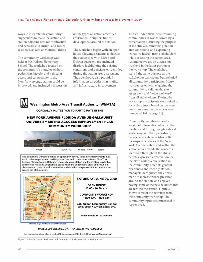
New York Avenue-Florida Avenue-Gallaudet University Station Access Improvement Study
ways to integrate the community’s suggestions to make the station and station-adjacent sites more attractive and accessible to current and future residents, as well as Metrorail riders.
The community workshop was held at J.O. Wilson Elementary School. The workshop focused on the community’s thoughts on how pedestrian, bicycle, and vehicular access and connectivity to the New York Avenue station could be improved, and included a discussion
on the types of station amenities envisioned to support future development around the station.
The workshop began with an open house allowing residents to discuss the station area with Metro and District agencies, and included displays highlighting the existing conditions and deficiencies identified during the station area assessment. The open house also provided information on pedestrian, traffic, and infrastructure improvement
studies undertaken for surrounding communities. It was followed by a presentation discussing the purpose of the study, summarizing station area conditions, and explaining “what we heard” from stakeholders while assessing the station area. An interactive group discussion was held in the latter portion of the workshop. The workshop served the same purpose as the stakeholder walkabout, but included all community participants. Metro was interested with engaging the community to validate the site assessment and “what we heard” from all stakeholders. During the workshop, participants were asked to focus their input based on the same questions asked in the survey (see numbered list on page 31).17
Community members shared a wealth of information—both at the meeting and through neighborhood leaders—about their pedestrian, bicycle, and vehicular (drop-off/ pick-up) experiences at the New York Avenue station and within the station area. Despite the concerns identified throughout the study, people expressed appreciation for the New York Avenue station in the community, noted its general cleanliness and friendly station managers, recognized the efforts made to increase police presence around the station, and enjoyed having some of the new retail tenants adjacent to the station. Figure 30 shows some of the activities from the community workshop. The community input is summarized in Appendix 1.
Figure 29: Mailer Sent to Residents and Commercial Businesses within Station Area
32 Section 3

New York Avenue-Florida Avenue-Gallaudet University Station Access Improvement Study
Figure 30: Activities during New York Avenue Station Open House and Workshop (clockwise from top left: discussing existing conditions with community members; Metro staff listen to areas of concern identified by community members during walkabout; community members identifying areas of concern on maps during workshop; poster boards presented at open house before presentation and workshop)
33Section 3


Future Station Area Characteristics Future Station Area Land Use
Demographics
Metrorail Ridership Forecast
Transportation Enhancements
Section 4
New York Avenue-Florida Avenue- Gallaudet University Station Access Improvement Study


New York Avenue-Florida Avenue-Gallaudet University Station Access Improvement Study
Future Station Area Land UseThe New York Avenue station area is and will be experiencing notable changes in character, reflected in the many development projects scheduled in NoMa and the release of a small-
Future Station Area Characteristics
area plan for the Florida Avenue Market. Residential moderate-density (26.6 percent), commercial medium-high density (18.3 percent), mixed use (13.6 percent), and production/technical employment (20.8 percent) types of land uses will dominate
Figure 31: Future Land Uses within New York Avenue Station Area
Source: Land use data from DCOP via DC GIS
37Section 4

New York Avenue-Florida Avenue-Gallaudet University Station Access Improvement Study
future development in the station area. Figure 31 shows the future land uses within the station area.18
NoMa Vision Plan and Devel-opment Strategy—DCOP (2009)The NoMa Vision Plan and Development Strategy, which DC Council adopted in 2009, outlines the schedule of proposed land use developments and streetscape improvements within NoMa. The neighborhood occupies a large portion of the New York Avenue station area and, thus, it would likely dictate many of the future land-use changes. In all, the NoMa Vision Plan calls for 10,000 to 13,000 new residential units providing housing for 16,000 to 24,000 people. It would also create 10 to 13 million square feet of new office space, adding 40,000 to 58,000 new daytime employees to NoMa.
As evidenced by some of the developments currently under construction in this neighborhood, the recommendations from the NoMa Vision Plan call for a mix of land-use types that will help promote efficiencies in transportation and increase neighborhood activities catering to transit users and pedestrians. The NoMa Vision Plan gives several recommendations for transportation and infrastructure enhancements to help improve pedestrian facilities, intensify use of the station, and increase vehicle circulation. Recommendations include developing a coordinated transportation management plan (completed in June 2010 by DDOT) and improving safety, connectivity, and accessibility around the station. While DDOT may implement some improvements, a significant number of the streetscape improvements that have occurred or will occur will be implemented by developers as part of their construction plans.
A change to the NoMa Vision Plan, outlined in a February 2009 clarification released by DCOP, eliminates the recommendation to study an extension of Second Street, NE between M and N Streets, NE due to the approval and construction of the Constitution Square development without the roadway extension. The following highlights relevant land use and transportation recommendations for NoMa.
Land Use The NoMA Vision Plan recommends land use mixes that promote diversity of residential, recreational,
cultural, employment, and shopping opportunities in the area. This can be accomplished by:
• Promoting efficiencies in transportation, through the two-way use of Metrorail, spreading of peaks, combining trips, and decreasing overall parking demand;
• Increasing activities in the neighborhood throughout the day, not just during typical business hours; and
• Discouraging scattered auto-centric development throughout NoMa, but rather concentrate
Figure 32: Map of Existing, Proposed, and Planned Land Uses19
Source: Adapted from NoMa BID, 2007
38 Section 4
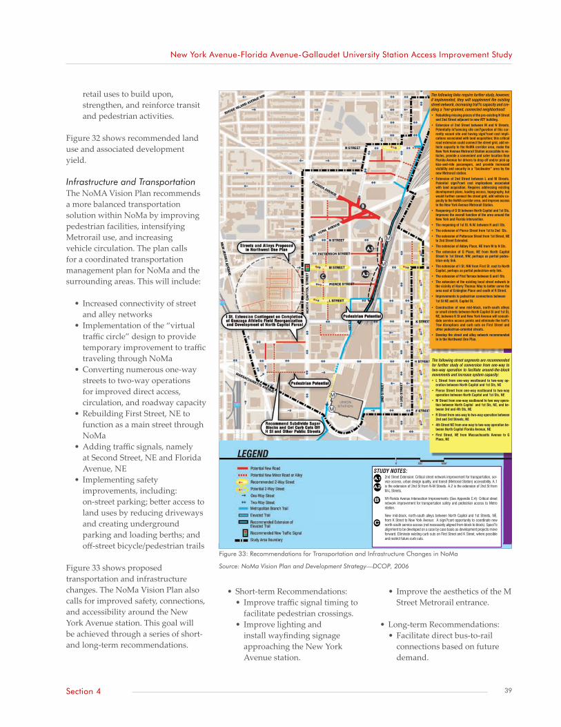
New York Avenue-Florida Avenue-Gallaudet University Station Access Improvement Study
retail uses to build upon, strengthen, and reinforce transit and pedestrian activities.
Figure 32 shows recommended land use and associated development yield.
Infrastructure and Transportation The NoMA Vision Plan recommends a more balanced transportation solution within NoMa by improving pedestrian facilities, intensifying Metrorail use, and increasing vehicle circulation. The plan calls for a coordinated transportation management plan for NoMa and the surrounding areas. This will include:
• Increased connectivity of street and alley networks
• Implementation of the “virtual traffic circle” design to provide temporary improvement to traffic traveling through NoMa
• Converting numerous one-way streets to two-way operations for improved direct access, circulation, and roadway capacity
• Rebuilding First Street, NE to function as a main street through NoMa
• Adding traffic signals, namely at Second Street, NE and Florida Avenue, NE
• Implementing safety improvements, including: on-street parking; better access to land uses by reducing driveways and creating underground parking and loading berths; and off-street bicycle/pedestrian trails
Figure 33 shows proposed transportation and infrastructure changes. The NoMa Vision Plan also calls for improved safety, connections, and accessibility around the New York Avenue station. This goal will be achieved through a series of short- and long-term recommendations.
• Short-term Recommendations:• Improve traffic signal timing to
facilitate pedestrian crossings.• Improve lighting and
install wayfinding signage approaching the New York Avenue station.
• Improve the aesthetics of the M Street Metrorail entrance.
• Long-term Recommendations:• Facilitate direct bus-to-rail
connections based on future demand.
TWO: INFRASTRUCTURE AND TRANSPORTATION
3.13
New Roads , Signals and Two-Way Streets
STUDY NOTES:2nd Street Extension: Critical street network improvement for transportation, ser-vice access, urban design quality, and transit (Metrorail Station) accessibility. A.1 is the extension of 2nd St from N-M Streets. A.2 is the extension of 2nd St from M-L Streets.
NY-Florida Avenue Intersection Improvements (See Appendix C.4): Critical street network improvement for transportation safety and pedestrian access to Metro station.
New mid-block, north-south alleys between North Capitol and 1st Streets, NE, from K Street to New York Avenue: A signi?cant opportunity to coordinate new north-south service access (not necessarily aligned from block to block). Speci?c alignment to be developed on a case by case basis as development projects move forward. Eliminate existing curb cuts on First Street and K Street, where possible and restrict future curb cuts.
B
A.1
C
A.2
The following links require further study, however, if implemented, they will supplement the existing street network, increasing traf?c capacity and cre-ating a ?ner-grained, connected neighborhood:• Rebuilding missing pieces of the pre-existing N Street
and 2nd Street adjacent to new ATF building.
• Extension of 2nd Street between M and N Streets. Potentially in?uencing site con?guration of this cur-rently vacant site and having signi?cant cost impli-cations associated with land acquisition; this critical road extension could connect the street grid, add ve-hicle capacity to the NoMA corridor area, make the New York Avenue Metrorail Station accessible to ve-hicles, provide a convenient and safer location than Florida Avenue for drivers to drop off and/or pick up kiss-and-ride passengers, and provide increased visibility and security in a “backwater” area by the new Metrorail station.
• Extension of 2nd Street between L and M Streets. Potential signi?cant cost implications associated with land acquisition. Requires addressing existing development plans, loading access, topography, but would further connect the street grid, add vehicle ca-pacity to the NoMA corridor area, and improve access to the New York Avenue Metrorail Station.
• Reopening of O St between North Capitol and 1st Sts. Improves the overall function of the area around the New York and Florida intersection.
• The reopening of 1st St. N.W. between H and I Sts.
• The extension of Pierce Street from 1st to 2nd Sts.
• The extension of Patterson Street from 1st Street, NE to 2nd Street Extended.
• The extension of Abbey Place, NE from M to N Sts.
• The extension of G Place, NE from North Capitol Street to 1st Street, NW, perhaps as partial pedes-trian-only link.
• The extension of I St. NW from First St. east to North Capitol, perhaps as partial pedestrian-only link.
• The extension of First Terrace between G and I Sts.
• The extension of the existing local street network in the vicinity of Harry Thomas Way to better serve the area east of Eckington Place and south of R Street.
• Improvements to pedestrian connections between1st St NE and N. Capitol St.
• Construction of new mid-block, north-south alleys or small streets between North Capitol St and 1st St, NE, between K St and New York Avenue will consoli-date service access points and eliminate the traf?c ?ow disruptions and curb cuts on First Street and other pedestrian-oriented streets.
• Develop the street and alley network recommended in in the Northwest One Plan.
The following street segments are recommended for further study of conversion from one-way to two-way operation to faciltate around-the-block movements and increase system capacity:• L Street from one-way westbound to two-way op-
eration between North Capitol and 1st Sts, NE
• Pierce Street from one-way eastbound to two-way operation between North Capitol and 1st Sts, NE
• M Street from one-way eastbound to two way opera-tion between North Capitol and 1st Sts, NE, and be-tween 3rd and 4th Sts, NE
• R Street from one-way to two-way operation between 2nd and 3rd Streets, NE
• 4th Street NE from one-way to two-way operation be-tween North Capitol Florida Avenue, NE
• First Street, NE from Massachusetts Avenue to G Place, NE
Figure 33: Recommendations for Transportation and Infrastructure Changes in NoMa
Source: NoMa Vision Plan and Development Strategy—DCOP, 2006
39Section 4

New York Avenue-Florida Avenue-Gallaudet University Station Access Improvement Study
• Promote planning of adjacent developments to increase visual awareness and, therefore, security.
• Increase vehicular access to the station by facilitating drop-offs and overall vehicular presence.
• Strengthen citywide transit connections, including the consideration of a circulator route along First Street, NE between NoMa and the Anacostia Waterfront (if development demand justifies it).
Table 7 supplements the list of recommendations, outlining project completion dates and lead agencies.
Florida Avenue Market Study, Small Area Plan—DCOP (2009)Florida Avenue Market Study created a framework to guide future development in this historic area. The area would be redeveloped to include mixed uses of moderate, medium, and high densities; would revitalize the wholesale/retail market; and would incorporate entertainment uses and ground floor retail to create a vibrant activity center east of the railroad embankment. Through adaptive
reuse of existing buildings, future development in the market would maintain its history while helping to create a sense of place.
The Florida Avenue Market Study developed recommendations to improve connectivity of the transportation network within the market area and to the surrounding communities. The study used design principles focusing on sense of place, open space, the public realm, and transportation, to develop several recommendations for each street within the Florida Avenue Market. The network within the market would become more multimodal: wider sidewalks to accommodate greater pedestrian activity, parking along low-volume streets to accommodate shoppers and aid in traffic calming, and certain streets designed to accommodate high traffic volumes and truck deliveries.
DemographicsDemographic information for the New York Avenue station area was based on 2000 Census data for traffic analysis zones (TAZs) created by the Metropolitan Washington Council of Governments (MWCOG). MWCOG forecasted population, household, and employment data for several periods out to 2030. The demographic information was further estimated based on the size of each TAZ encompassed by the station boundary. Table 8 lists the results of this estimation, projected for 2005 and 2030.
Metrorail Ridership ForecastBased on future growth in the station area, boardings and alightings for the New York Avenue station are expected to increase through 2030. According to Metrorail ridership
Table 7: NoMa Plan Action Agenda
Action Year Lead Role
Make transportation improvements to intersection of New York Avenue, NE and Florida Avenue, NE FY2007 – 2009 DDOT
Rebuild 1st Street, NE as proposed in ’07, re-design to support NoMa plan design goals FY2007 DDOT
Construct proposed underpass improvements and incorporate art installations FY2007 DDOT/OP/DCCAH
Create NoMa Transportation Management Plan (including pedestrian, bicycle, and transit) FY2007 DDOT/Metro
Amend DDOT’s Street and Highway Plan to incorporate recommendations from NoMa Plan FY2007 DDOT
Increase NoMa’s ability to handle projected traffic volumes, increase mobility and access by further study, and construction of recommended improvements to signalization, street direction, street extension
FY2007- 2009 Metro/DDOT/BID
Develop coordination/implementation strategy for roadway extensions and alley proposals FY2007 – 2009 CID/DDOT/OP
Relocate bus routes to access new Metrorail Station; in the short term strengthen north-south transit service with shuttle connecting Metro Station area with Union Station
FY2006 – 2007 Metro/DDOT
Assist Metro with Metro Station Area Access Plan, for safety improvements and wayfinding FY2006 – 2007 Metro/DDOT/OP
Develop better city-wide connections; study extension of K Street Transitway to the tracks FY2006 – 2012 DDOT/OP/Metro
Ensure that Greyhound bus depot stays within proximity of the Amtrak, New York Avenue Metrorail Station and continue efforts to be incorporated into a multi-modal transit hub
FY2007 -2012 BID/GH/USDC
Source: Adapted from NoMa Vision Plan and Development Strategy—DCOP, 2006
Table 8: Baseline and Forecasted Demographics for New York Avenue Station Area
Year Population Households Employees
2005 8,340 3,107 19,337
2030 19,529 13,754 47,547
Change 134% 343% 146%
Source: MWCOG Round 7.1 household and employment forecasts
40 Section 4

New York Avenue-Florida Avenue-Gallaudet University Station Access Improvement Study
data, the New York Avenue station showed a 35 percent growth in average weekday ridership between June 2007 and June 2008. This ranked the New York Avenue station second in highest growing ridership rates, behind the Navy Yard (112 percent growth) and ahead of the Columbia Heights (23 percent growth) stations. Development surrounding the Navy Yard and Columbia Heights stations has been significant within the past few years, while development surrounding the New York Avenue station has not reached its peak. According to Metro’s Metrorail Station Access & Capacity Study (2008), ridership is expected to increase by 13 percent between 2005 and 2010, 34 percent between 2010 and 2015, and 20 percent between 2020 and 2030.
Transportation EnhancementsThe New York Avenue station area has been subject to major transportation activity in recent years: it contains three principle arterials (two of which are or have been subject to major transportation studies) and an intercity bus terminal that may be relocated to nearby Union Station, an intermodal hub. Development occurring around the New York Avenue station has also provided opportunities for increasing connectivity to the New York Avenue station, including N and Second Streets, NE, which were built as part of the ATF headquarters development. Metro encourages new links connecting to the station as new construction is planned and will work cooperatively with agencies such as DDOT and DCOP to ensure such connections happen.
The following summarizes some current efforts being undertaken to ease travel and enhance connectivity to the New York Avenue station area.
Florida Avenue Neighborhood Access Study and Transporta-tion Management Plan—DDOT (2010)In summer 2009, DDOT initiated a study to improve neighborhood access by developing a transportation plan for NoMA. The purpose of the study is to look for ways to improve multimodal access, on-street parking management, and circulation within the NoMa BID area. A portion of the study considered the viability of removing one lane of traffic in each direction on Florida Avenue, NE between Second and Sixth Streets, NE to smooth the transition of vehicles entering and leaving the virtual traffic circle at the Florida Avenue/New York Avenue intersection. The study was completed in June 2010.
DC Neighborhood Circulation Study—Metro and DDOT (2009)A study recently released by Metro outlines several transit enhancements to improve circulation and connectivity throughout the District. DC Neighborhood Circulation Study recommends a span of service increase for the X3 bus route from peak-hour-only service to 15-hour service. This change includes buses running every 15 minutes during the peak hours and every 20 minutes during the off-peak hours.
The study also recommends the introduction of shuttle service to better connect underserved neighborhoods to the New York Avenue station. These recommendations greatly affect the Trinidad neighborhood. Although Trinidad is outside the defined New York Avenue station area, the recommendations would increase its connectivity to Metrorail and existing and future development within the area. Figure 34 on the following page shows the proposed circulator route.
Metropolitan Branch Trail Draft Concept Plan—DDOT (2005)The Metropolitan Branch Trail is an interconnected network of on- and off-street trails connecting parts of Montgomery and Prince George’s Counties in Maryland to the District. The trail consists of 10 segments, four of which pass through the New York Avenue station area.
The following are relevant recommendations and information outlined by trail segment:
First Street, NE between Louisi-ana Avenue and L Street, NE (see Figure 35)• Stripe bike lanes between G and K
Streets, NE (note: these lanes will need to be restriped after most of the construction in the area is completed).
• Construct a ramp from the railroad track level to the corner of Second and L Streets¸ NE. In addition, construct a shared-use path leading from the railroad tracks to the corner of First and L Streets, NE once One NoMa Station undergoes redevelopment.
• Create at-grade crossings at K and L Streets, NE along First Street, NE. The plan recommends the use of typical bike lane designs at these intersections.
• Create a gateway/wayside location at L Street, NE possibly in the form of a shaded plaza.
Second Street between East End of Union Station and L Street, NE (see Figure 35)• Create a trail crossing at K and L
Streets, NE designed using the trail/roadway standards outlined in the Bicycle Design Guide.
New York Avenue Station (see Figure 36)• This segment will provide users
a direct traffic-free connection
41Section 4
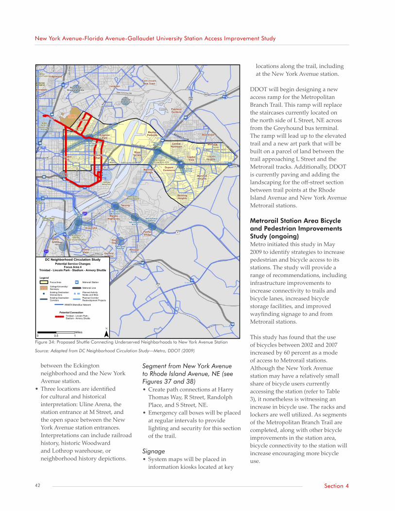
New York Avenue-Florida Avenue-Gallaudet University Station Access Improvement Study
between the Eckington neighborhood and the New York Avenue station.
• Three locations are identified for cultural and historical interpretation: Uline Arena, the station entrance at M Street, and the open space between the New York Avenue station entrances. Interpretations can include railroad history, historic Woodward and Lothrop warehouse, or neighborhood history depictions.
Segment from New York Avenue to Rhode Island Avenue, NE (see Figures 37 and 38)• Create path connections at Harry
Thomas Way, R Street, Randolph Place, and S Street, NE.
• Emergency call boxes will be placed at regular intervals to provide lighting and security for this section of the trail.
Signage• System maps will be placed in
information kiosks located at key
locations along the trail, including at the New York Avenue station.
DDOT will begin designing a new access ramp for the Metropolitan Branch Trail. This ramp will replace the staircases currently located on the north side of L Street, NE across from the Greyhound bus terminal. The ramp will lead up to the elevated trail and a new art park that will be built on a parcel of land between the trail approaching L Street and the Metrorail tracks. Additionally, DDOT is currently paving and adding the landscaping for the off-street section between trail points at the Rhode Island Avenue and New York Avenue Metrorail stations.
Metrorail Station Area Bicycle and Pedestrian Improvements Study (ongoing)Metro initiated this study in May 2009 to identify strategies to increase pedestrian and bicycle access to its stations. The study will provide a range of recommendations, including infrastructure improvements to increase connectivity to trails and bicycle lanes, increased bicycle storage facilities, and improved wayfinding signage to and from Metrorail stations.
This study has found that the use of bicycles between 2002 and 2007 increased by 60 percent as a mode of access to Metrorail stations. Although the New York Avenue station may have a relatively small share of bicycle users currently accessing the station (refer to Table 3), it nonetheless is witnessing an increase in bicycle use. The racks and lockers are well utilized. As segments of the Metropolitan Branch Trail are completed, along with other bicycle improvements in the station area, bicycle connectivity to the station will increase encouraging more bicycle use.
%&h(
%&h(
AÑ
Ah
I|
?¼
?½
Rhode Island Ave NW
New York Ave NW
Nor
East Capitol St SE
Benning Rd NE
Maryland Ave NE
Borroughs Ave NE
Blad
ensb
u rg
Rd N
E
12th St S
E
Pennsylvania Ave SE
Minnesota Ave SE
Suitland Pkwy SE
Alabama
Av
e SE
Southern
Ave S
E
Mar
tin L
uthe
r Kin
g, J
r. A
ve S
E
4th
Stre
et N
E
10th
Stre
et N
E
Florida Ave NW
Constitution Ave NE
New York Ave NE
GallaudetUniversity
RFKStadium
DCArmory
Cheverly
Deanwood
Suitland
Anacostia
Navy Yard
Branch Ave
Potomac Ave
Naylor Road
BenningRoad
Southern Ave
Minnesota Ave
Union Station
Capitol South
Stadium-Armory
Eastern Market
Capitol Heights
Rhode IslandAve
Congress Heights
New York Ave -Florida Ave
MLK/Malcolm X
Good Hope/MLK
Good Hope/Alabama
Benning/Minnesota
E Capitol/Benning
Pennsylvania/Branch
Pennsylvania/Alabama
Pennsylvania/Minnesota
Benning/Florida/H Street
St. Elizabeth'sHospital
THEARC
EasternMarket
BrentwoodShopping Center
NationalArboretum
Ana
cost
ia R
iver
Anacostia R iver
EastCapitol
Major Investment Area
Minnesota-Benning Metro Area
Major Investment Area
CongressHeights
Major Investment Area
NoMA(North of
MassachusettsAvenue)
AnacostiaGateway
Major Investment Area
Hill EastWaterfront
Far SE/SW - BellviewMajor Investment Area
H StreetCorridor
Georgia AvenueCutlural District
SoutheastFederal Center
Howard RoadDevelopment
McMillanReservoir Project
Minnesota/Massachusetts
Bellevue
Twining
CongressHeights
Anacostia
GarfieldHeights
BenningHeights
CapitolHill
Trinidad
Fort LincolnNew Town
CapitolView
Langdon
Brookland
Bloomingdale
Edgewood
BarryFarms
WashingtonHighlands
RandleHighlands
FairfaxVillage
Hillcrest
GoodHope
CongressPark
BuenaVista
MarshallHeights
LincolnPark
MayfairParkside
DupontCommons
LincolnHeights
BurrvilleCentralNortheast
BannekerRidge
RiverTerrace
KingmanPark
Deanwood
EastlandGardens
DC Neighborhood Circulation Study
¯
Legend
Existing DestinationIntersections!!!
Planned ActivityNodes and Sites!!!
Existing DestinationCorridors
Planned CorridorRedevelopment Projects
Metrorail LineCollege/University/Seminary
AmericanUniversity
Focus Area Metrorail Station"M
WMATA MetroBus Network
0 0.5 1Miles
Potential Service ChangesFocus Area 4
Trinidad - Lincoln Park - Stadium - Armory Shuttle
Potential ConnectionTrinidad - Lincoln Park -Stadium - Armory Shuttle
Figure 34: Proposed Shuttle Connecting Underserved Neighborhoods to New York Avenue Station
Source: Adapted from DC Neighborhood Circulation Study—Metro, DDOT (2009)
42 Section 4

New
Yor
k A
venu
e-Fl
orid
a A
venu
e-G
alla
udet
Uni
vers
ity S
tatio
n A
cces
s Im
pro
vem
ent
Stud
y
Figu
re 3
5: T
rail
Segm
ent f
rom
Uni
on S
tatio
n al
ong
Firs
t and
Sec
ond
Stre
ets,
NE
to P
iece
Str
eet,
NE
Sour
ce: M
etro
polit
an B
ranc
h Tr
ail C
once
pt P
lan—
DD
OT,
200
5
43Se
ctio
n 4
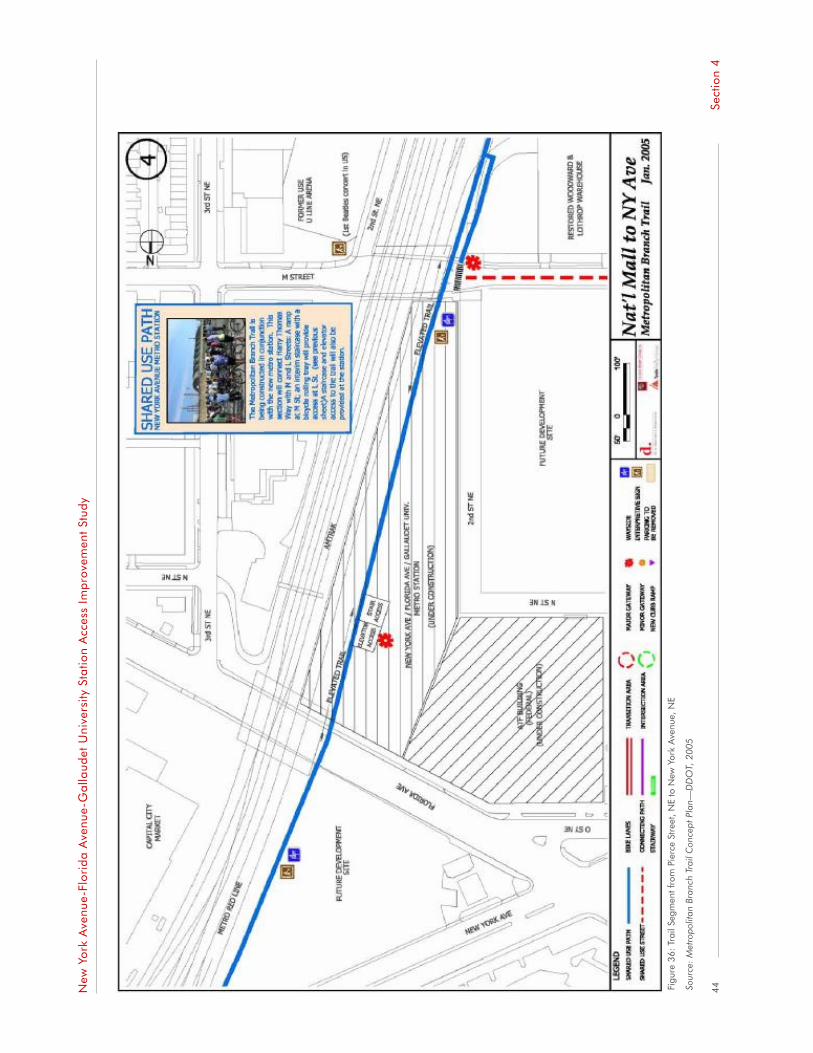
New
Yor
k A
venu
e-Fl
orid
a A
venu
e-G
alla
udet
Uni
vers
ity S
tatio
n A
cces
s Im
pro
vem
ent
Stud
y
Figu
re 3
6: T
rail
Segm
ent f
rom
Pie
rce
Stre
et, N
E to
New
Yor
k A
venu
e, N
E
Sour
ce: M
etro
polit
an B
ranc
h Tr
ail C
once
pt P
lan—
DD
OT,
200
5
44Se
ctio
n 4

New
Yor
k A
venu
e-Fl
orid
a A
venu
e-G
alla
udet
Uni
vers
ity S
tatio
n A
cces
s Im
pro
vem
ent
Stud
y
Figu
re 3
7: T
rail
Segm
ent f
rom
New
Yor
k A
venu
e, N
E to
Ran
dolp
h Pl
ace,
NE
Sour
ce: M
etro
polit
an B
ranc
h Tr
ail C
once
pt P
lan—
DD
OT,
200
5
45Se
ctio
n 4

New
Yor
k A
venu
e-Fl
orid
a A
venu
e-G
alla
udet
Uni
vers
ity S
tatio
n A
cces
s Im
pro
vem
ent
Stud
y
Figu
re 3
8: T
rail
Segm
ent f
rom
Ran
dolp
h Pl
ace,
NE
to T
Str
eet,
NE
Sour
ce: M
etro
polit
an B
ranc
h Tr
ail C
once
pt P
lan—
DD
OT,
200
5
46Se
ctio
n 4
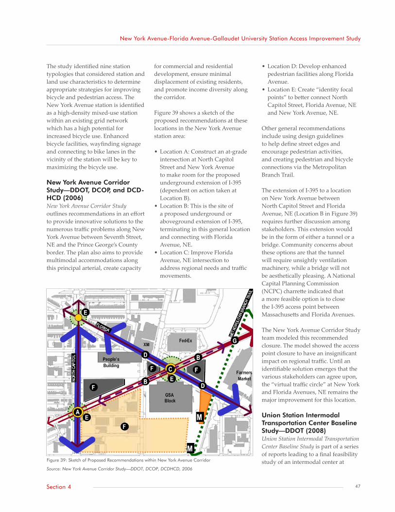
New York Avenue-Florida Avenue-Gallaudet University Station Access Improvement Study
Figure 39: Sketch of Proposed Recommendations within New York Avenue Corridor
Source: New York Avenue Corridor Study—DDOT, DCOP, DCDHCD, 2006
The study identified nine station typologies that considered station and land use characteristics to determine appropriate strategies for improving bicycle and pedestrian access. The New York Avenue station is identified as a high-density mixed-use station within an existing grid network which has a high potential for increased bicycle use. Enhanced bicycle facilities, wayfinding signage and connecting to bike lanes in the vicinity of the station will be key to maximizing the bicycle use.
New York Avenue Corridor Study—DDOT, DCOP, and DCD-HCD (2006)New York Avenue Corridor Study outlines recommendations in an effort to provide innovative solutions to the numerous traffic problems along New York Avenue between Seventh Street, NE and the Prince George’s County border. The plan also aims to provide multimodal accommodations along this principal arterial, create capacity
for commercial and residential development, ensure minimal displacement of existing residents, and promote income diversity along the corridor.
Figure 39 shows a sketch of the proposed recommendations at these locations in the New York Avenue station area:
• Location A: Construct an at-grade intersection at North Capitol Street and New York Avenue to make room for the proposed underground extension of I-395 (dependent on action taken at Location B).
• Location B: This is the site of a proposed underground or aboveground extension of I-395, terminating in this general location and connecting with Florida Avenue, NE.
• Location C: Improve Florida Avenue, NE intersection to address regional needs and traffic movements.
• Location D: Develop enhanced pedestrian facilities along Florida Avenue.
• Location E: Create “identity focal points” to better connect North Capitol Street, Florida Avenue, NE and New York Avenue, NE.
Other general recommendations include using design guidelines to help define street edges and encourage pedestrian activities, and creating pedestrian and bicycle connections via the Metropolitan Branch Trail.
The extension of I-395 to a location on New York Avenue between North Capitol Street and Florida Avenue, NE (Location B in Figure 39) requires further discussion among stakeholders. This extension would be in the form of either a tunnel or a bridge. Community concerns about these options are that the tunnel will require unsightly ventilation machinery, while a bridge will not be aesthetically pleasing. A National Capital Planning Commission (NCPC) charrette indicated that a more feasible option is to close the I-395 access point between Massachusetts and Florida Avenues.
The New York Avenue Corridor Study team modeled this recommended closure. The model showed the access point closure to have an insignificant impact on regional traffic. Until an identifiable solution emerges that the various stakeholders can agree upon, the “virtual traffic circle” at New York and Florida Avenues, NE remains the major improvement for this location.
Union Station Intermodal Transportation Center Baseline Study—DDOT (2008)Union Station Intermodal Transportation Center Baseline Study is part of a series of reports leading to a final feasibility study of an intermodal center at
47Section 4

New York Avenue-Florida Avenue-Gallaudet University Station Access Improvement Study
Union Station. It assesses the baseline conditions of the Union Station area, of which a small portion overlaps with the south end of the New York Avenue station area. The study reviews existing uses, operations, and conditions for the various modes using Union Station as a terminus.
Although preliminary, a relevant recommendation of the study is construction of a Metrorail entrance to connect the intermodal center with future streetcar operations either along the H Street Bridge or beneath it with the track lowered to street level. This connection, if implemented, would give users at the south fringe of the New York Avenue station area improved access to multiple transportation modes.
District of Columbia Transit Future System Plan - DDOT (2010)The District of Columbia Transit Future System Plan establishes the vision of the future transit system for the District that includes new streetcar services and the continued expansion of Metrobus express services. This plan is based on the original system plan completed in 2005 and a refinement plan completed in 2008. A recommendation relevant to the New York Avenue station is the Florida Avenue Streetcar segment which connects the Shaw Howard University and New York Avenue stations via Florida Avenue and extends to the H Street commercial center. This segment would serve the rapidly growing NoMa district and the New York Avenue station area as well as the densely populated neighborhoods and Gallaudet University.
48 Section 4


Station Area Recommendations
Transportation Network
Pedestrian Safety
Overpasses and Other Infrastructure
Wayfinding
Station Facilities
Aesthetics
Land Development
Section 5
New York Avenue-Florida Avenue- Gallaudet University Station Access Improvement Study


New York Avenue-Florida Avenue-Gallaudet University Station Access Improvement Study
Station Area Recommendations
Transportation Network
Pedestrian ElementsThe pedestrian environment within the station area is of major concern. Primarily, narrow sidewalks—typically, less than six feet wide—are scattered throughout the station area. Some of these sidewalks, especially those on the south side of Florida Avenue, NE, are adjacent to vehicular traffic traveling at high speeds relative to pedestrian traffic. There are no buffers between pedestrians and vehicles.
Some intersections need new or restriped crosswalks and new or repaired pedestrian signals with audible signals for those who are visually impaired. The time given to cross the New York Avenue/Florida Avenue, NE intersection may also be inadequate and can negatively affect the pedestrian experience for those using the New York Avenue station.
Bicycle ElementsBicycle concerns include the lack of crosstown connectivity for bicycle lanes within the New York Avenue station area. Except for an on-street connection to the Metropolitan Branch Trail planned at L Street, NE between its current access point and First Street, NE there are no designated crosstown bicycle routes near the New York Avenue station.
The bicycle recommendations include supporting enhanced crosstown connectivity to existing bicycle routes in the District, enhanced bicycle facilities at the station and improved wayfinding.
Recommendations for improving access to and from the New York Avenue station address both the areas that Metro owns and areas that others control. Metro owns or has easements only for the area where it conducts Metrorail operations. Many access issues are outside these areas. Executing the majority of recommendations, therefore, will rely on coordination with various other agencies and organizations, including but not limited to DDOT, DCOP, Amtrak, NoMa BID, and DC Department of Public Works (DPW).
Recommendations are arranged in seven categories: (1) transportation network, (2) pedestrian safety, (3) overpasses and other infrastructure, (4) wayfinding, (5) station facilities, (6) aesthetics, and (7) land development. A brief description of the issues for each category is followed by the associated recommendations. Each recommendation provides suggested implementation periods:
• Short-term: at most two years• Mid-term: two to five years• Long-term: more than five years
Many recommendations respond to comments received during community involvement activities. Detailed comments received from the community are contained in the technical memorandum, Stakeholder Walkabout and Community Workshop Summary (2009).
All recommendations, unless noted otherwise, are applicable within the limits of the New York Avenue station area. Recommendations are summarized in Table 9.
53Section 5

New York Avenue-Florida Avenue-Gallaudet University Station Access Improvement Study
Roadway ElementsSome drivers use the M Street, NE entrance as a de-facto Kiss & Ride site. At that location, there is only one 11-foot traffic lane in each direction. Drivers behind a stopped vehicle may be tempted to cross the yellow dividing line. With these lanes sandwiched between steel columns that support the overpass, hazardous conflicts can occur. Shuttle buses also stop at the New York Avenue station, boarding and alighting passengers on the north side of M Street, NE at Delaware Avenue, NE. Although the roadway is wider at this location (about a 30-foot paved surface width), vehicles are not supposed to stand or park there, according to DDOT’s signed regulation.
Further analysis is required by Metro to address passenger drop-off and pick-up at the station.
Pedestrian SafetyThere are various issues affecting pedestrian safety within the New York Avenue station area. Roadways conditions along Florida Avenue, NE between Fourth and Eighth Streets, NE have created hazards for those walking along or crossing Florida Avenue, NE.
Lighting levels along some streets within the station area, as well as the combined effects of limited pedestrian activity and the presence of boisterous and homeless people after dark make some station users uncomfortable, potentially affecting their use of the station during such late at night.
The curb ramp and trench drain near the newly opened Courtyard by Marriott both have grade changes that can create potential hazards for some pedestrians.
Overpasses and Other InfrastructureMetro and DDOT have cooperated on repairing portions of the overpasses at Florida Avenue, NE and K, L, and M Streets, NE within Metro’s responsibility. Portions of the overpasses under Amtrak’s responsibility experience falling debris, cracked ceilings, or water seepage.
Elements such as lampposts and traffic signal control cabinets on sidewalks obstruct the pedestrian walking path and further narrow those sidewalks. Disabled people cannot use those sidewalks because there is no room in which to maneuver in wheelchairs or with walking aides.
WayfindingOnly one wayfinding sign exists within the New York Avenue station area. People who are either approaching or exiting the Metrorail system lack guidance on traveling to and from key destinations within the area.
Station FacilitiesThe New York Avenue station is relatively new within the Metrorail system, opening for operations in November 2004. It has few issues, based on findings from the recent report Metrorail Station Access & Capacity Study (2008), field observations, and comments from the community.
Private vehicles owned by Metro employees are often parked in the open space beneath the elevated Metropolitan Branch Trail at the station. This area should only be used for official Metro activities related to the operations and maintenance of the New York Avenue station. Metro
should strengthen its enforcement of this no parking zone.
AestheticsFoliage and landscaping are spare at and surrounding the New York Avenue station and are absent along M Street, NE between the overpass and Third Street, NE. Supplementing artwork at and near the station can also enhance the area and make the trip to the station more enjoyable.
Land DevelopmentA diversity of other retail types—banking, dry cleaning, convenience markets—and entertainment venues that are both located closer to the station and in a pedestrian-friendly setting also should be explored.
54 Section 5

New York Avenue-Florida Avenue-Gallaudet University Station Access Improvement Study
Table 9: Summary of Station Area Recommendations
Recommendations Responsible Agency Implementation Period
Transportation Network
Ensure NoMa Neighborhood Access Study and Transportation Management Plan investigates roadway reduction and sidewalk widening along Florida Avenue, NE
DDOT Mid-term
Install traffic signal and crosswalk at intersection of Second Street and Florida Avenue, NE concurrent with completion of Washington Gateway development at location as recommended in NoMa Vision Plan and Development Strategy (2006)
DDOT Mid- to long-term
Ensure sufficiency of pedestrian signal times at intersection of Florida and New York Avenues, NE as part of New York/Florida Avenue intersection reconfiguration (also supported by recommendation in NoMa Vision Plan and Development Strategy (2006))
DDOT Short-term
Continue implementing bicycle facilities along Delaware Avenue and L Street, NE to increase connectivity to New York Avenue station, as recommended in the Metropolitan Branch Trail Draft Concept Plan (2005) and the NoMa Vision Plan and Development Strategy (2006)
DDOT Mid-term
Ensure NoMa Neighborhood Access Study and Transportation Management Plan investigates additional bicycle facilities to promote cross town travel with New York Avenue station area
DDOT Short-term
Consider designating the north side of M Street, NE between Delaware Avenue and Third Street for vehicle pick-up/drop-off (until future creation of one at Florida Avenue entrance), similar to recommendations made in KLM Small-Area Traffic Study (2006)
DDOT Short-term
Make “No Standing or Parking Anytime” signs between Delaware Avenue, NE and front of M Street, NE station entrance more conspicuous and enforce regulation
DDOT, MPD, DPW Short-term
Pedestrian Safety
Investigate solutions to hazardous pedestrian conditions along Florida Avenue, NE between Fourth and Eighth Streets, NE (supported in part by recommendation in Florida Avenue Market Study: Small Area Plan (2009))
DDOT Mid-term
Trim overhanging tree branches covering traffic control signals and warning signs along north side of Florida Avenue, NE between Sixth and Eighth Streets, NE
DDOT, Gallaudet University
Short-term
Implement recommendations based on the work done for Safe Routes to School (SRTS) program for Two Rivers Public Charter School
DDOT Upon acceptance of SRTS final report
Investigate pedestrian lighting conditions at following locations: beneath overpass at Florida Avenue and L and M Streets, NE; Fourth and L Streets, NE; east along M Street, NE; and along Sixth Street, NE between Florida Avenue and station area limit
DDOT Short- to mid-term
Consider viability of increased security options (including cameras) around the station, in addition to cameras already installed within the station property
Metro Short- to mid-term
Continue collaborative efforts to create secure presence in surrounding area NoMa BID, MPD Ongoing
Add tactile truncated domes to approaches of the following elements: trench drain along Second Street, NE in front of Courtyard by Marriott and orphan curb ramp near southeast corner of Second Street and Florida Avenue, NE
DDOT Short-term
Overpass and Other Infrastructure
Repair weeping along embankment walls and areas of profound cracking on ceiling of overpasses at Florida Avenue, NE and L, M, and K Streets, NE
Amtrak Short- to mid-term
Study possibility of relocating utilities such as lampposts and traffic signal controller cabinets from middle of narrow sidewalks, especially along south side of Florida Avenue, NE
DDOT Mid- to long-term
Wayfinding
Identify locations for wayfinding signage throughout the New York Avenue station area as recommended in NoMa Vision Plan and Development Strategy (2006). Consider community recommendations for the locations of wayfinding signage at key destinations.
DDOT Short-term
Correct “Gallaudet College” to read “Gallaudet University” on existing wayfinding signage located at First and K Streets, NE.
DDOT Short-tern
Station Facilities
Continue monitoring and enforcing policies regarding illegal parking on Metro property for activities not related to Metrorail operations and maintenance
Metro Continuous
55Section 5

New York Avenue-Florida Avenue-Gallaudet University Station Access Improvement Study
Table 9 (continued): Summary of Station Area Recommendations
Recommendations Responsible Agency Implementation Period
Aesthetics
Increase clean-up efforts at and around station; engage local agencies, organizations, and retail establishments in assisting with clean-up
Metro; NoMa BID; ANCs 5B, 5C, and 6A; DPW
Short-term
Increase foliage and landscaping at and surrounding station NoMa BID, DDOT-Urban Forestry Administration
Short- to mid-term
Identify locations for artwork—particularly those leading to and at the station—and funding for artwork and commissioned artists
Metro; NoMa BID; ANCs 5B, 5C, and 6A; DC Arts and Humanities Commission; DDOT; DCOP
Short- to mid-term
Land Development
Keep community abreast of planned retail and entertainment establishments surrounding the New York Avenue station; engage community in identifying additional retail and entertainment opportunities to better serve its needs near the station
DCOP Periodically
Ensure development occurs that includes connectivity to New York Avenue station DCOP, NoMa BID Continuous
56 Section 5


Appendices
Appendix 1: Community Input
Appendix 2: Endnotes
New York Avenue-Florida Avenue- Gallaudet University Station Access Improvement Study
Image: flickr user TrailVoice


New York Avenue-Florida Avenue-Gallaudet University Station Access Improvement Study
Appendix 1: Community InputTable A-1: Summary of Comments from Community Walkabout and Workshop
Topics Key Issues within Station Area
Transportation Network • Poor sidewalk conditions: narrow, cracked, uneven, containing potholes, or missing. Affect pedestrians’ sense of safety and comfort when walking to and from station. Some locations include: north side of M Street, NE from Third Street, NE to Florida Avenue, NE; south side of Florida Avenue, NE particularly beneath overpass
• Inadequate time for pedestrians to cross New York/Florida Avenues, NE
• Potential walking hazards for hearing- and visually impaired pedestrians: unexpected grade change for curb ramp at southeast corner of Second Street, NE and Florida Avenue, NE and trench drain next to Courtyard by Marriott entrance
• Bicycle lane needed on First Street, NE between H and K Streets, NE
• Some and audible recordings for pedestrian signals along Florida Avenue, NE between the overpass and West Virginia Avenue, Ne have been damaged
• Creating a formal vehicle drop-off/pick-up area at the station
Pedestrian Safety • Numerous safety concerns about Florida Avenue, NE:
• Improvements to the visibility of roadway signs and signals to make drivers more aware of pedestrians—especially impaired pedestrians—walking along the corridor
• Measures to ensure drivers yield to pedestrians along Florida Avenue, NE—including at unsignalized crossings
• Measures to reduce speeding along the corridor, especially at the intersections of New York Avenue, NE, Fourth Street, NE, Fifth Street, NE, Sixth Street, NE and West Virginia Avenue NE with Florida Avenue, NE
• Improved pedestrian conditions for the intersection at Fifth Street, NE
• Feelings of discomfort and lack of safety walking along narrow sidewalks, particularly those leading to north station entrance
• Need for increased street lighting at: overpass at Florida Avenue and L and M Streets, NE; Fourth and L Streets, NE; east along M Street, NE; and along Sixth Street, NE within the station area
• Lack of pedestrians and presence of homeless and boisterous people near station at night contribute to feelings of insecurity
• Desire for increased policing and other security measures around immediate station area
• Vehicles parked on pedestrians paths along Third Street, NE between Florida Avenue and M Street, NE as well as along Sixth Street, NE between Neal Place and Florida Avenue, NE
Overpasses and Other Infrastructure • Falling debris and weeping beneath the overpass at Florida Avenue, NE
• Rehabilitating other half of the overpass at M Street, NE
• Lampposts and traffic signal control cabinets on sidewalks obstructing pedestrian access to New York Avenue station. Primary locations is south side of Florida Avenue, NE from overpass to Eighth Street NE
Wayfinding • Signs needed at following locations and for following landmarks:
• Northern and southern Metro station entrances
• North Capitol and First Streets, NE
• Florida Avenue and Second Street, NE
• 1st and N Streets, NE
• 1st and M Streets, NE
• 2nd and L Streets, NE
• From New York Avenue, Florida Avenue, and K Street, NE
• East of the New York Avenue station
• New York Avenue station
• Greyhound terminal
• Gallaudet University
61Appendices

New York Avenue-Florida Avenue-Gallaudet University Station Access Improvement Study
Table A-1 (continued): Summary of Comments from Community Walkabout and Workshop
Topics Key Issues within Station Area
Station Facilities • Need for more bicycle racks
• Damaged cigarette receptacle at south entrance
• Need for more trash receptacles
• Ensure escalators in working condition
Aesthetics • Need for additional landscaping at and surrounding the station; need for increased plantings of trees and grass
• Maintaining cleanliness of some nearby retail and residential locations, as well as station entrances
• Additional artwork. Potential locations include: stone walls of the embankments at Florida Avenue, NE and K, L and M Streets, NE as well as sites east of the embankment
Land Development • Desire for variety of pedestrian-friendly retail, entertainment, and financial establishments in immediate station area
• Improve connectivity between the east side of the community and the New York Avenue station
• Potential for farmers’ market beneath Metropolitan Branch Trail on Metro’s easement
62 Appendices
New York Avenue-Florida Avenue-Gallaudet University Station Access Improvement Study
Appendix 2: EndnotesSection 1
Section 2
1. The station name was changed from “New York Ave” to “New York Ave–Florida Ave–Gallaudet U” while under construction in 2004.
2. An infill station is one built on an existing transit line between existing stations.
3. National Council for Public-Private Partnership, New York Avenue Metro Station, Washington DC; PB Consult, New York Avenue-Florida Avenue-Gallaudet University Metro Station: A Case Study
4. The boundary descriptions are general in nature. Because neighborhood boundaries are constantly changing, District government will typically group neighborhoods by clusters for planning purposes.
5. Information is based on a November 2009 Metro press release, celebrating five years of service at the New York Avenue station.
6. Average weekday boardings and alightings were calculated by dividing the total number of station entries/exits by the product of the number of weekdays in a week over a 52-week period.
7. Toole Design Group (2007). District of Columbia Pedestrian Master Plan: High Pedestrian Activity/ High Deficiency Roadways.
8. A sidewalk gap is considered more than 10 percent of a block’s length.
9. DDOT (2008). District of Columbia Pedestrian Master Plan, Appendix A, p. 1.
10. Such a hazard could occur when hearing-impaired pedestrians are walking and signing. If the grade change is not anticipated, injuries could occur.
11. Fifteen-hundred feet is the largest radius allowable for compiling data using MPD’s crime map database.
12. http://app.ddot.dc.gov/information_dsf/construction/current_default.asp (current as of January 7, 2010)
13. “Journeys,” created by sculptor Barbara Grygutis and DC poet laureate Dolores Kendricks, is “an integration of words into artwork.” It comprises the illuminated aluminum sculpture greeting Metrorail riders at the northern entrance and a 500-linear-foot steel railing with embedded artwork. The artwork adds dimension to and enhances the pedestrian experience at the New York Avenue station.
14. NoMa BID services information: http://www.nomabid.org/index.cfm?objectid=85760DC9-F1F6-6035-B28BB6E48B17C048
15. NoMa BID (2008). NoMa BID Receives $50,000 Matching Public Art Grant from D.C. http://www.nomabid.org/index.cfm?objectID=3F533D30-1D09-317F-BBD8AAEABB5B3A24
16. Urban Forestry Administration’s tree planting schedule (currently showing 2009-2010 schedule): http://trees.ddot.dc.gov/ufa/cwp/view,a,1293,q,645837,ufaNav_GID,1631,ufaNav,|32699|.asp
17. The questions are similar to those given to local community leaders to ask of constituents prior to the workshop.
Section 3
Section 418. Land use data is based on the most recent data from DCOP submitted in December 2006, based on The Comprehensive Plan for the National Capital: District Elements.
19. The map was created for MRP Realty and posted on NoMa BID’s web site (MRP Realty (2007). NoMa Development Map.
63Appendices


