The right of publication in print, electronic and any other form and in any language is reserved by WMO. Short extracts from WMO publications may be reproduced without authorization, provided that the complete source is clearly indicated. Editorial correspondence and requests to publish, reproduce or translate this publication in part or in whole should be addressed to:
The designations employed in WMO publications and the presentation of material in this publication do not imply the expression of any opin-ion whatsoever on the part of WMO concerning the legal status of any country, territory, city or area, or of its authorities, or concerning the delimitation of its frontiers or boundaries.
The mention of specific companies or products does not imply that they are endorsed or recommended by WMO in preference to others of a similar nature which are not mentioned or advertised.
The findings, interpretations and conclusions expressed in WMO publications with named authors are those of the authors alone and do not necessarily reflect those of WMO or its Members.
This publication has been issued without formal editing.
WORLD METEOROLOGICAL ORGANIZATION
GLOBAL ATMOSPHERE WATCH
WMO GURME Workshop on
Urban Meteorological Observation Design
Shanghai Meteorological Bureau, Shanghai, China 11 - 14 December 2011
Summary Report by
Walter F. Dabberdt (Chair), Alexander Baklanov, Gregory R. Carmichael, V. Chandrasekar,
C. Susan B. Grimmond, Pertti Nurmi, Kevin Petty, Volker Wulfmeyer and Tang Xu
2. SUMMARY OF THE WORKSHOP SESSIONS .......................................................................................1
A. Opening ceremony ............................................................................................................................1
B. Session 1 – Top-level design ............................................................................................................1
C. Session 2 – Ground-based system design for different service needs .............................................4
D. Session 3 – Observation system of the urban boundary layer ..........................................................7
E. Session 4 – Observations of urban high-impact weather systems and applications.........................10
F. Session 5 – Analysis of the interaction between urban-scale circulation and atmospheric chemistry ....................................................................................................................12
G. Session 6 – Applications of urban observations................................................................................15
A. End users, their needs and societal aspects.....................................................................................18
B. Transportation ...................................................................................................................................20
C. Surface energy fluxes .......................................................................................................................24
D. Remote sensing: profiling and volumetric sampling ..........................................................................25
E. Maritime observations .......................................................................................................................28
F. Air quality...........................................................................................................................................29
G. Network design and station siting......................................................................................................30
H. Modelling, model evaluation and verification.....................................................................................33
I. Crosscutting issues ...........................................................................................................................35
4. REMARKS ON SMB ACTIVITIES............................................................................................................37
ANNEX A - Workshop participants ..............................................................................................................39
ANNEX B - Workshop agenda ....................................................................................................................43
1
1. INTRODUCTION
An international scientific advisory group met in Shanghai, China, 11-13 December, 2011, with the task to review the design for urban meteorological observations. The group was to especially examine the plans by the Shanghai Meteorological Bureau (SMB) of the China Meteorological Administration (CMA) for an enhanced urban atmospheric network and to provide more general advice on this subject to the Global Atmosphere Watch (GAW) Urban Research Meteorology and Environment (GURME) of the World Meteorological Organization (WMO). The objectives of the enhanced network are to provide improved meteorological and air chemistry measurements that would greatly increase SMB’s ability to monitor the current state of atmospheric (and related Earth surface) conditions in order to better define various atmospheric-related risks and hazards and improve their mitigation through improved forecasts and predictions. This enhanced atmospheric observation network would also provide a key, improved climate record and quantify climate change throughout the region.
The international scientific advisory group included members from five countries: Denmark, Finland, Germany, the United Kingdom and the United States. The group was joined by the WMO AER Chief and 35 experts from China, representing CMA, SMB, the Jiangsu Meteorological Bureau, the Anhui Meteorological Bureau, the CMA Shanghai Typhoon Institute, Peking University, the Chinese Academy of Sciences, the Anhui Meteorological Sciences Institute, and the Zhejiang Meteorological Bureau (Annex A). The workshop (agenda in Annex B) comprised three days of presentations and formulation of recommendations (11-13 December 2011) followed by a day of informal advisory group discussions
2. SUMMARY OF THE WORKSHOP SESSIONS
A. Opening ceremony The workshop opened with welcoming remarks by Dr Yu Rucong, CMA Deputy
Administrator, and Dr Liisa Jalkanen, WMO Atmospheric Environment Research (AER) Division Chief. Dr Yu spoke to the timeliness and importance of the plans being developed by the Shanghai Meteorological Bureau, and how they could serve as a model for improving the observation networks and forecasting performance in cities and provinces throughout China. In her opening remarks, Dr Jalkanen spoke of GURME and how it seeks to address some of the pressing technical, social and environmental stressors that are driving the demand for more accurate and user friendly environmental assessments and predictions in relation to climate change, population growth, and urbanization. The SMB plans and this workshop are another step forward in defining and meeting those challenges.
B. Session 1 – Top-level design
This session provided key background information for the goals of the workshop; three keynote presentations reviewed the progress of the Shanghai WMO GURME Pilot Project, summarized the state of knowledge on urban meteorology, and reviewed urban observations and measurement technologies.
The presentation by Prof. Gregory Carmichael and Dr Zhou Guangqiang on an “Overview of the Shanghai GURME Project” reviewed the goals and outcomes of the Shanghai WMO GURME Pilot Project that was conducted during the period 2006-2010. The goals of the pilot project were to:
• Investigate the physical and chemical mechanism during the transport and transformation processes of atmospheric pollutants in the Shanghai megacity
• Better understand the impact of air pollutants on low-visibility episodes (such as fog, haze, etc.)
2
• Establish a chemical weather forecasting system to improve the capacity of prediction, warning and regulation for urban and regional air quality
• Understand the impact of weather and environment on human health, and to develop adaption techniques.
In summarizing the outcomes, three broad sets of results were identified:
• SMB greatly extended its understanding and knowledge of atmospheric physics and chemistry issues in the Shanghai megacity, such as the typical phenomena of “urban ovens” and “urban chimneys”
• SMB significantly enhanced its capacity building for PBL observations, numerical weather prediction and human health-meteorology forecasting, which played an important social role during the 2010 Shanghai EXPO
• SMB strengthened the capabilities of its teams and provided expert training for continuous development of the staff’s scientific activities and operational practices in the field of urban environment and meteorology.
Prof. Sue Grimmond’s presentation on “Urban Meteorology” summarized the state of
knowledge and the key needs pertaining to urban meteorology. The effects of various urbanization processes were shown to impact atmospheric conditions on the local and regional scales. Various key features of the urban environment were covered, including the urban heat island, solar radiation trapping, heat storage by buildings and earth surfaces, wind flow (and its modification), the important role of anthropogenic heat emissions, precipitation processes and their modification, and the role of vegetation. The urban zone is heterogeneous and so is the spatial distribution of the urban meteorology. Effective numerical modelling of the atmosphere in the urban zone requires the use of sophisticated land surface models and physics appropriate to the urban boundary-layer. Prof. Grimmond went on to summarize high-level recommendations and needs in each of several areas. In the area of observations, more operational urban measurement stations and networks are needed within urban areas and also in the upwind domain; these include the need for vertical profiles of both physical and chemical variables. Also needed are long-term measurement records in cities to meet various climate requirements. In all cases, meticulous station metadata records are crucial and permanent data archives are essential. Much remains to be done to understand and quantify atmospheric processes in urban areas. In the area of modelling, there are multiple needs, including improvements in:
• Short-range, high-resolution numerical prediction of weather, air quality and chemical
dispersion • Modelling of biogeophysical features of the urban land surface for the exchange of
heat, moisture, momentum and radiation within the atmospheric urban boundary layer • Data assimilation methods for meteorological and biogeophysical data from improved
observing networks.
Also needed is greater emphasis on and commitment to knowledge exchange. This includes ensuring the widespread training of the meteorological community about urban meteorology, promoting an appreciation of the role of meteorology and hydrology in urban planning and management of sustainable cities of all sizes, and communication across scientific disciplines.
Dr Walter Dabberdt’s presentation on “Urban observations and measurement technologies” discussed the pressing challenge to properly measure the state of the atmosphere in a way that enables both the quantification of the atmospheric state at any time and the prediction of changes in time using numerical models and other techniques (e.g., nowcasting). Determination of a region’s operational needs for meteorological and air quality observations also requires a deep understanding of the needs of the end-user groups and their respective atmospheric information needs and data requirements. Measurement needs differ significantly according to the latency requirements of the application. Applications that depend on the current state of the atmosphere largely do so directly on local observations near the ground and aloft. Very short-range forecasts (“nowcasts”) – out to 60min or so – use increasingly sophisticated heuristic methods that
3
extrapolate current conditions. Beyond a few hours, mesoscale numerical prediction models are initialized with upper-air data from ground-based and space-based profiling and volumetric sampling devices together with boundary conditions provided by smaller-scale (larger domain) models while data assimilation methods optimize the use of these data in the forecast continuum (resulting in significant improvements in NWP performance). Dabberdt’s presentation reviewed various measurement technology options, including: radar wind profilers, sodar, atmospheric lidar (aerosol or elastic backscatter devices, differential absorption, and Raman scattering systems), passive microwave radiometric profilers (MWRP), radiosondes, commercial aircraft pressure-temperature-humidity-wind systems, and volumetric soil moisture devices. There are also several other measurement options and gaps needing attention in the urban zone. These include improved low-level, high-resolution radar networks, total (cloud-to-ground and in-cloud) lightning observation systems, appropriate metadata for all observing systems, effective network-design tools, and urban-regional prototype networks to evaluate and refine observing network designs and predictive models. The session concluded with a keynote presentation by Dr Tang Xu, who outlined the plans and goals of the SMB in his presentation on “Shanghai Integrated Urban Observations – the Status Quo and Future Science- and User-Driven Needs and Requirements.” Dr Tang discussed Shanghai’s needs for an integrated urban observation system, the status of its current observation network, the science-and user-driven needs and requirements in the coming years, and the expected outcomes of the workshop. As one of seven regional meteorological centres in China, SMB is responsible for providing weather/climate related services to Shanghai local government and citizens as well as technical guidance and coordination within East China region. SMB’s goal is to provide the necessary atmospheric and land surface measurements required for all the processes that influence urban environments at multiple temporal and spatial scales. These multi-processes meteorological and air chemistry measurements include those occurring in the boundary layer as well as the free atmosphere, which are linked to and impact one another. As a result, the urban atmosphere needs to be addressed as an integrated system with integrated measurement, modelling and application solutions.
Through the previous WMO-Shanghai GURME Pilot Project, SMB greatly extended its understanding and knowledge of atmospheric physics and chemistry issues in the Shanghai megacity; and it significantly enhanced its capacity for PBL observations, numerical weather prediction and weather-related health impact forecasting (e.g., in support of the 2010 Shanghai EXPO). At the same time, it is recognized that the urban atmosphere is measured in a discrete and deficient manner thus leading to a limited ability to assess the true state of the urban environment. Going forward, SMB looks to build an urban observing system that will be greatly strengthened when data collection and analysis are achieved in an integrated manner. The integrated urban observation system should address multiple aspects or dimensions: various observing (measurement) systems and platforms; full integration of all platforms; a comprehensive data management and quality control/assurance system; improved coordination of strategies and instruments; identification of observing gaps (in space, time, or parameter); and the use of an advanced data assimilation system. SMB sees two broad types of forecasts that it must provide: 1) those that are specific to the efficiency or productivity of various end-user groups, such as utilities (power consumption and production planning), transport (least time routine), recreation (land, sea & air), agriculture, horticulture, water resources, and security for large events (Expo); and 2) warnings where there are threats to life, property, transport (land, sea & air), utilities (electricity, gas, fuel, water, drainage, telecommunication), industry (mainly construction on land and sea), and the environment. To meet emerging science-based and-user-driven needs and requirements, SMB plans to develop and implement a coordinated, multi-year plan to enhance and integrate its observation systems to minimize data gaps and maximize the quality, integrity and unity of the data acquired. In this regard, the SMB Director General identified some expected outcomes of the workshop.
4
Process of integration: • What experience gained from the WMO GURME Shanghai Pilot Project can be used to
further develop the SMB observing system? • What level of integration is desired and cost-effective? • Which observing system functions will be integrated? • What tools and methods (e.g., testbeds) should be used to accomplish the integration
of the observing system functions? • What plans need to be developed and implemented?
SMB Observing System Upgrades
• Do current observations meet the requirements of urban applications? Where are they lacking? What is the highest priority in terms of observations?
• How can observations be improved to meet modelling and operational demands? • How should an existing observing system be updated and designed to meet the
emerging requirements for weather and climate research and applications in urban environments? Which sensors, procedures, and processes are needed?
• Which measurement strategies will provide the best benefit for cost? • What are the requirements across the spectrum of data gathering, collection,
assimilation, archival, and dissemination processes? How can we address them? C. Session 2 – Ground-based system design for different service needs The presentation by Dr Yang Limin on “Ground-based system design based on different service needs” and the ensuing discussion provided an understanding of the needs and requirements of various Shanghai-related services, with a focus on the transportation observation network in and around the city, the use of buildings in observing critical weather-related parameters, and monitoring high-traffic indoor facilities (e.g., train stations, sports centres, etc.). Like most megacities, Shanghai is faced with the need to observe and monitor key atmospheric parameters in an effort to ensure the highest level of services possible to protect life and property, maximize mobility and efficiency, and promote the general well-being of the population. Moreover, it is important that this is accomplished through cost-effective solutions. With a location adjacent to the East China Sea, a population in excess of 18 million people, an area of nearly 3000 square kilometres, and a multifaceted urban infrastructure, Shanghai presents considerable and complex challenges when it comes to observing the necessary parameters that can be used to facilitate and optimize services. Transportation management, energy operations, construction, environmental protection, and health and safety are just some of the service sectors that would benefit from enhanced atmospheric observations, as these observations would enable effective monitoring and early warning capabilities. These sectors are sensitive to a number of high-impact weather events including, but not limited to, flooding, typhoons, heat-waves, haze, and high winds. As communicated during Dr Yang’s presentation, an essential aspect of an effective service is the ability of the service to deliver early warnings regarding high-impact weather events. In the case of Shanghai, observations are needed for several parameters. Table 1 shows a list of desired ground-based observing capabilities that would help facilitate superior services. A description of the current observing assets was described. These assets consist of a diverse array of systems such as automated weather systems, weather radars, wind profilers, radiosondes, video monitoring, and mobile observations, to name just a few. However, strategic deployment of additional observing platforms is necessary to better address Shanghai’s wide-ranging service needs. Although it is clear that a number of services would benefit from the ability to deliver more accurate, timely weather-related information through the use of enhanced observations, Yang’s presentation focused on two important service areas, transportation management and indoor monitoring. Transportation management consists of managing roadway traffic, railway activity, coastal and port ship movement, and aviation (ground and air traffic). Indoor monitoring is concerned with observing conditions in heavily populated enclosed or partially enclosed facilities
5
such as subway and railway stations, stadiums, and shopping centres. One other topic that received considerable attention during the session was building-based observations -- deploying observing systems and sensors using tall structures in the urban environment (e.g., buildings, bridges, etc.). It is believed that tall structures throughout Shanghai could potentially be leveraged to create observations and datasets that would allow research associated with near-surface atmospheric stability to be conducted, as well as support the development of operational early warning systems and services, particularly those related to public health and safety.
Table 1- Required observation capabilities for enhanced early warnings
Observation Target Needs Precipitation Heavy rain Hail Detection Freezing rain detection Wind High Winds Wind Shear
Vertical Gradient Visibility Heavy Fog
Haze Fire Fire Source
Smoke Source
Green House Gas/Pollution Chemical Releases O3,CH4,NO,NO2,SO2,CO,CO2 Particulate Matter (PM1, PM2.5, PM10)
Transportation observing network Initial discussion during the session was dedicated to the transportation management topic. Although transportation management incorporates several transportation sectors, the primary emphasis of the discussion was placed on roadway operations. During the discussion, three central questions were asked.
• What are the experiences outside of Shanghai and China? • Where should transportation observing systems be deployed? • What are the best measurement strategies in terms of cost/benefit?
The advisory group was able to provide a considerable amount of insight in terms of international experiences. There is a sizable amount of this in the area of weather observations and their relation to roadway operations and service. Much of this experience is centred on maximizing roadway safety, mobility and efficiency, while minimizing maintenance-related costs, generally from the perspective of winter weather. However, in recent years, observing activities associated with roadway operations have also recognized the benefit of observations during other high-impact weather events (e.g., heavy rain, low visibility). It was noted that the United Kingdom and Scandinavian countries such as Finland have a lot of experience in observing and forecasting weather conditions that have an impact on the transportation system. In addition, international organizations have been formed to allow operational entities and research institutes throughout the world to share information and techniques for addressing the weather-related needs pertaining to surface transportation. SIRWEC (Standing International Road Weather Commission) was noted during the discussion as an organization that could potentially contribute to SMB from the standpoint of leveraging international experience and knowhow to meet future goals and objectives in the
6
Shanghai region. SIRWEC serves as a forum for information exchange in the area of road weather, with a focus on management, maintenance, safety, and the environment. It may also be beneficial for SMB to increase its involvement in Intelligent Transportation System (ITS) Associations. Regional organizations (America, Europe, Asia-Pacific) sponsor the World Congress on Intelligent Transport Systems (ITS), which is a viable opportunity to gather other information about transportation technologies and practices, including weather observing systems and services. Finally, consideration should also be given to developing relationships and partnerships with research institutes and organizations that can aid SMB in its mission. One such institute that was identified during the session is the Finnish Meteorological Institute (FMI), which has years of experience in observing and predicting surface weather conditions for transportation systems. Not only can SMB interact with international organizations and countries (research and operations) to gain additional awareness and guidance to meet transportation needs and requirements, but international experience can also be acquired through the acquisition and review of standards and guidance documents and materials. The Road Weather Information System Environmental Sensing Station Siting Guidelines published by the United States Federal Highway Administration is one example of a resource that can be used to support the rollout of new and improved surface transportation capabilities. The experts also noted that SMB collaboration with the international community will help answer immediate questions and uncover ancillary observing techniques, nowcasting and forecasting approaches, and weather-related applications for transportation operations. Thermal Mapping, which is a technique that is used to determine the temperature characteristics along a road or runway network, is an example of a technique that has been successfully applied to support the deployment of transportation weather-observing systems. It also has allowed transportation managers to gain more comprehensive understanding of climatic zones throughout a roadway or runway network. Additionally, research institutes (e.g., FMI) and private companies have developed forecast models to predict the evolution of the state of road and runway surfaces based on data originating from transportation weather-observing systems. Predictive competencies will enhance transportation-based services through improved early warning capabilities. Building-based atmospheric observations As previously noted, SMB’s interest in this topic was primarily from the perspective of deploying sensors using tall structures in the urban environment with the goal of determining the atmospheric stability as well as the flow structure and pollution distribution within the urban setting. Key questions included the following:
• Where should sensors be placed in terms of high-rise buildings and tall structures? • What vertical resolution should be achieved? • What new sensors and measurement techniques should be used?
One of the most important outcomes of the discussion was the need to have SMB clearly define its goals and objectives, since this is fundamental to defining the optimum approach for sensor placement. The goals and objectives should also be clearly prioritized. Prioritization can aid in planning the appropriate strategy for installing sensors, ensuring synergy with current and future observing systems, and developing techniques that can take full advantage of network observations. This is required for making appropriate suggestions and recommendations about how and where to deploy building-based sensors. If building-based observations are going to be used in the context of research, the deployment strategy and sensor selection approach will depend upon the goal. For example, if the goal is to run computational fluid dynamics (CFD) models, there should be an effort to capture observations on spatial and temporal scales that will facilitate effective operation and verification of the models. In contrast, if the goal is to create real-time techniques and applications, then the strategy used to gather building-based observations may look much different. In the end, the overall goals and objectives will ultimately determine what sensors should be deployed and where.
7
Discussion amongst the advisory group underscored the fact that the urban environment is extremely complex and significant variations occur over very small distances (horizontal and vertical). Great care needs to be used when leveraging buildings to acquire data in the urban environment. Data representativeness is crucial regardless of whether the focus is on research or operations. The urban environment presents a host of challenges (e.g., flow distortion) when trying to install and maintain sensors so that the derived data are truly representative of the atmospheric conditions at the buildings, as well as in and around the urban canyons. It was also noted that when selecting observing sites, strong consideration should be given to installing sensors that will deliver information on the vertical profile of the near-surface atmosphere. In other words, it is not only helpful to locate sensors near the tops of structures, but additional value will be obtained if sensors are deployed between buildings. Furthermore, every effort should be made to gather data on temperature and humidity in the vertical, not just wind speed and direction. Finally, the suggestion was made that thought should be given to the deployment of remote scanning devices (e.g., LIDAR), as such systems can contribute vital information on vertical structure that can support both research and operations. Indoor area monitoring Finally, a small portion of the discussion during the session was spent on indoor area monitoring. From SMB’s perspective, the intent was to address the following questions in the context of indoor monitoring:
• What are the experiences outside of China? • Which sensors, methods, standards, and processes are needed? • How should sensors be placed for representativeness?
The discussion on this topic returned to some of the same factors that were discussed earlier in relation to the other topics. The answers to the second and third bullets are highly dependent on the key goals and objectives of the indoor monitoring initiative. The end applications will essentially drive the type of sensors that should be deployed, where the sensors should be positioned, and the requirements for data representativeness. Therefore, it is important to define and concentrate on the high priority applications when it comes to indoor monitoring. D. Session 3 – Observation system of the urban boundary layer This session focused on various aspects of the observation system requirements pertaining to the urban boundary-layer (UBL). Particularly, the session addressed the network design considerations for observing the UBL structure. Special effects such as urban heat islands, urban wind, and urban surface fluxes were considered. It was realized that a specific observation design requirement includes the surface energy balance and the estimation technology of the heat produced by human activities. However, also the complex 3D structure of the UBL has to be observed, as fine structures will determine the locations of severe events such as extreme temperatures and precipitation. This calls for a comprehensive application of remote sensing techniques (fixed and mobile observation, vertical observation, sampling, and 3D scanning, etc.) in addition to more traditional in situ measurements. Last but not least, the potential value of various observations for data assimilation and NWP was elaborated. Presentations - The session included three presentations:
Sue Grimmond: “Characterization of energy flux partitioning in urban environments: Links with Surface Seasonal Properties”
Yang Limin: “Urban boundary layer character information acquisition system through different observation technologies (including the combination of various observation techniques and methods, mobile and fixed observations, gradient observations, vertical detection, sampling)” and
Yin Qiu: “Urban monitoring integrated with remote sensing data, AWS, and NWP”.
8
Prof. Sue Grimmond: “Characterization of Energy Flux Partitioning in Urban Environments: Links with Surface Seasonal Properties” This presentation focused on the land surface concerning urban meteorological observation modelling such as source areas/footprints, anthropogenic heat flux, and the characterization of energy flux partitioning in urban environments. It was demonstrated that due to the complex small scale feature of the urban environment (building structures, building density and shape, vegetation pattern) these measurements are extremely challenging. Measurement footprints are strongly dependent on the meteorological conditions. The footprints are different for different variables of interest. It is important to study whether and how these overlap when investigating the energy balance closure. Urban effects on wind, radiation balance and heat balance characteristics vary with time and season at different scales, as demonstrated by observations and modelling with London and Singapore as examples. The observation and modelling results were verified. The heat from the fixed, mobile and population sources were analyzed by the measurement of EBC should be spelled out closure. It was pointed out that we still need to ensure the consistency of measurements for many applications. It is important to make sure that the data are representative for the respective use. Different scales should be considered for the different demands on the anthropogenic heat flux. Prof. Grimmond introduced 3-4 general methods to show the general consistency. In the last part of the presentation, the characterization of urban energy balance fluxes, variability of latent heat flux, storage heat flux and net radiation were described. The FRAISE (Flux Ratio – Active Index Surface Exchange) model was introduced with active source index of vegetation and building. Prof. Grimmond discussed how the analysis of surface characteristics allows the identification of the key processes within the area being modelled. These characteristics are used within models to provide the lower boundary condition for land surface models. By analyzing these it is possible to identify what areas have similar characteristics and what are different -- and therefore may need additional measurements. For each instrument there is coverage with respect to temporal and spatial resolution. This coverage may be static or dynamic depending on the type of variable being measured and the principles of the observation technique. The instrument performance and the measured variables including error characteristics can be analyzed by end-to-end performance models. Using this model, the area (absolute or probabilistic) that was sampled can be identified. This allows assessment of what areas the observations represent. It is then possible to compare the areas that need to be modelled with the areas of the observations to evaluate what type of areas and variables are currently well observed and what type of areas are currently not well represented. Ideally a common land surface atmosphere model should be used to characterize the area of the observations and to define the area in the numerical prediction model. For example, the active built index and the active vegetation index can be determined from the surface characteristics (Loridan and Grimmond, 2012a) and can be used for numerical modelling (Loridan and Grimmond 2012b). Similarly, end-to-end performance models have been developed and applied for passive and active remote sensing systems such as MWRs and FTIRs as well as radar and lidar systems.
9
Figure 1 - Schematic of the determination of instrument requirements based on land surface characteristics
(Loridan and Grimmond, 2012 a,b)
Dr Yang Limin: “Urban boundary layer character information acquisition system through different observation technologies (including the combination of various observation techniques and methods, mobile and fixed observations, gradient observations, vertical detection, sampling)” In relation to urban features in Shanghai and for observation of UBL characteristics, a wind profiler network, an AWS network, gradient observation systems using towers, an adaptive observation system and a multi-functional observation station in the Expo park and on Sheshan island have been set up. Shanghai plans to add: two more boundary wind profilers and one troposphere wind profiler; more AWS stations in the urban horizontal scale and vertical scale depending on building distribution, city layout and density of population; more observation sensors on the tower; and an adaptive observation system for more experiments of scientific research of UBL and for user-driven services. The Expo Testbed monitors a comprehensive suite of meteorological parameters using different methodologies, and the observation data are applied comprehensively for derivation of multi-characteristics of boundary layer and cloud properties. Lidar and ceilometer, microwave radiometer for hail forecasts, and total sky imager and ceilometer indicate rationality of mutual verification among instruments at the same time and site. In the future, more lidars or ceilometers will be added for routine observation. Meanwhile, depending on experiences abroad regarding model operation and forecast services, Shanghai will seek to establish additional testbeds for atmospheric features in sensitive areas over Shanghai. Dr Yin Qiu: “Urban monitoring integrated with remote sensing data, AWS, and NWP” This presentation introduced the requirements of remote sensing for fine-scale, quality-controlled monitoring as well as evaluation of the urban meteorological state. The monitoring data will need to be provided with appropriate spatial and temporal resolution gridded for regional numerical weather prediction, especially focusing on: 1) Fine-scale evaluation of the urban heat island 2) Monitoring of fog and haze 3) Monitoring of atmospheric particulate matter
10
4) Type and vertical distribution of urban near-surface conditions for the parameterization of the urban canopy layer 5) Atmospheric water vapour for data assimilation
The different kinds of satellite remote sensing data received by SMB and their application on these five items, the current progress and existed problems, were analyzed in detail. Based on those analyses, the presentation took an outlook of future developments on improving ground-based observations for providing better use of remote sensing. Particularly, it was suggested that there is a need for: 1) synchronous observations of related variables for different urban surfaces, 2) horizontal multispectral extinction observations instead of visibility observations, 3) ground-based observations of vertical profiles of aerosol concentration and size distribution index, 4) application of high resolution remote sensing data to establish urban building and environment databases, and 5) integrated application of different water vapour information for numerical weather prediction . Discussion. In the lively discussion of this Session, several recommendations emerged that are briefly summarized here and discussed in greater detail in Section 3 of this report: Thematic Recommendations. Surface fluxes and variables:
• Establish data base on surface properties • Perform routine footprint analyses and energy balance closure (EBC) at specific
locations • Measure anthropogenic heat fluxes by EBC using eddy covariance (EC) stations and
radiation instruments • Upscale fluxes for model verification and improvement • Test urban canopy parameterizations • Determine surface temperature fields by merging satellite remote sensing and surface
data
ABL structure: • Key variables are 3D dynamics and thermodynamics in the preconvective environment • Densify network of aerosol and atmospheric measurements in combination with
testbeds, synergy with satellite obs • For 2D wind, Doppler LOS and dual Doppler measurements should be applied, may
require densification of radar network • The required resolution and accuracy for temperature and WV profiling and data
assimilation can be achieved by lidar remote sensing (Raman and DIAL); consider 3D scanning
• Use GPS slant total delays (STDs) for studying the low-level water-vapour field and for data assimilation
• The information content of backscatter lidar (dynamics, ABL depth, AOD) should be optimally exploited by comparisons with models and direct lidar data assimilation
E. Session 4 – Observations of urban high-impact weather systems and applications Session 4 included four presentations that were concerned with techniques to observe high-impact weather:
V. Chandrasekar-- ‘Radar advances and opportunities’. Volker Wulfmeyer -- ‘Thermodynamic profiling and opportunities’ Yang Yinming, Dai Jianhua, Liu Hong Ya, and Chen Lei -- ‘Integrated Observation
System Design Based on High impact Weather’ Lei Xiaotu, Zhao Binke, and Fang Pinzi-- ‘Typhoon Observation in SMB’
11
In the first two presentations, instrumentation and techniques were described that have been recently developed and utilized for measurement of precipitation processes and thermodynamic profiles. These provide observations on the vertical structure of the atmosphere. In the latter two presentations, results from observational capabilities already in place within Shanghai and the vicinity were described and future plans were also identified. From the four presentations and discussions, a number of key points were identified and that are described below. Vertical observations provide useful information for a variety of applications, such as data assimilation, improved model performance, and model evaluation and verification. There are a variety of new instruments under development that could provide useful additional information in the near- to mid-term. This includes, for example:
• The capability to obtain thermal and humidity profiles from Raman lidar and Differential Absorption Lidar (DIAL). These approaches have the advantage of providing much improved vertical resolution compared to other techniques such as passive microwave radiometers.
• New technology allows adaptive use of small X- or C-band radar networks to continuously monitor hydrometeors at higher spatial and temporal resolutions than otherwise would be conventionally available. With this technology there is improved space and time resolution of short-lived but severely damaging convective storms within cities. These techniques enable observations that are close to the ground, in contrast to traditional radars, thereby allowing detection, for example, of thunderstorm-generating tornadoes that cannot be resolved with traditional radars. They also provide accurate quantitative precipitation estimation (QPE) and short-term quantitative precipitation forecasting (QPF) by the use of polarimetric retrieval which is useful both for small-scale rain events as well as rain events from large-scale events such as typhoons.
With new technologies it is helpful to test equipment in operational settings. If instruments are co-located, it is possible to evaluate their performance relative to a variety of other similar and complementary instrumentation. Instrument testbeds, like the ARM CART sites (http://www.arm.gov/sites), allow evaluation of the utility of new instruments. The SMB may wish to consider setting up one or more testbed sites in Shanghai Province. This would allow for consideration of new technologies, such as those presented, to be evaluated in an operational setting. The testbed(s) would ensure that the observations were being conducted in areas that are of interest and representative of the Shanghai region. Consideration should also be given to developing a nested network design that addresses the meteorological variability at regional, urban and local scales. Ideally, as part of the testbed and testing of the instruments, data assimilation methods should also be evaluated. In the presentations, vertical profiles of temperature, humidity, precipitation, wind and radar reflectivity were all identified as having new observation techniques that would provide useful data. As the scale of meteorological phenomena become larger the area of interest for providing observations to inform predictions similarly becomes larger. At the same time, the observational networks can provide data for a wide variety of processes that are of interest and there is an opportunity for sharing of data and instrumentation resources. Given the high impact of weather systems coming from the ocean area (e.g., typhoons), it would be beneficial to have enhanced marine observations and collaborations with neighbouring areas, notably Japan. There are a number of ways additional information could be obtained from maritime locations. For example, collaborative use of dropsondes, with consideration given to whether the application is for improved tropical cyclone intensity and/or trajectory purposes; and exploring if ships in the region could be used for collecting appropriate data (routine, event related). Offshore lightning observations can also be a useful resource for a range of convective phenomena. The benefits of enhanced radar coverage from coastal and offshore island locations were also discussed.
12
Observations of mixing layer height and structure and entrainment were also discussed as being very important for a number of applications. As there are multiple methods to observe and define these, it is critical to ensure consistency between observations and model definitions. A common theme across all four presentations is the importance of integration across all three components of the problem: observations, modelling and applications. For example, if a prediction is being made (e.g., heat wave, cold wave, flooding) that requires people to respond (e.g., vacate an area,), then it is critical that the time it takes for people (general population and emergency personnel alike) to respond be taken into account. That is, the forecast needs to be timely in terms of end-users’ needs. This therefore influences the prediction latency time and the suite of observations that can be used to provide the greatest contribution to the forecast and warning. With this in mind, it is important to identify which data assimilation schemes would most improve predictions and model performance. These will likely vary depending on the synoptic conditions. For example, different vertical information is more useful or needed under different synoptic conditions. Radar is useful when precipitation is occurring within the region of interest and when it is moving in from adjacent regions (nowcasting). Thermodynamic lidar data are more useful when systems are developing. Thus the two are complementary in terms of the periods when they will provide their most informative data. In this way, one overarching goal must be to ensure that observations, analyses, modelling and applications are all compatible and consistent with one another. This has implications for spatial and temporal sampling of variables. It is therefore relevant that models be evaluated (variables, scales, etc.) at multiple locations. As model performance is improved in one part of the model, it is critical to ensure that model performance is not negatively impacted or degraded by other changes in model development. It is therefore critical to ensure the model sub-components are not getting ‘correct’ results for the wrong reasons (e.g., these deficient sub-components could later be fixed and thus have a cascading effect on model performance errors). Thus it is useful to undertake model evaluation with multiple variables and to have continued repeat benchmarking and verification. Data analysis and observations are closely linked. Often there are multiple ways to observe atmospheric variables as they evolve in space and time; combining observations from disparate observing systems can provide enhanced insight and more reliable results. For example, in the case of precipitation processes, there are both continuous space-time volumetric observations (such as scanning precipitation radar) and in-situ point observations (such as gages). A combination of physical models and retrieval techniques should then be used to represent the “end to end” meteorological phenomena of interest, where the space time variability at high space-time resolution is observed with volumetric remote sensing networks and where the in situ observations are used as anchor points. F. Session 5 – Analysis of the interaction between urban-scale circulation and
atmospheric chemistry
This session focused on the analysis of the interaction between urban-scale circulation and atmospheric chemistry. The overall scope of the session included: design of observations for urban atmospheric chemistry; observations for stable characteristics of the urban atmosphere (boundary layer height, atmospheric stability, etc.); observations of local circulation (sea breeze, heat island circulation, lake breeze) and impacts on atmospheric pollutants; urban haze weather observations (low visibility, aerosol hygroscopicity); and atmospheric aerosol and gaseous pollution observations using satellite remote-sensing and urban boundary-layer gradient techniques. Three presentations were made:
Gregory Carmichael - “Urban atmospheric chemistry: state of the art and challenges;” Zhao Chunsheng - “Urban haze weather observations;” and Xu Jianmin - “Monitoring atmospheric composition in Shanghai Megacity: challenge
and task.”
13
Looking specifically at the needs of SMB, an overview of the challenges and opportunities for improved prediction and analysis through a closer integration of models and observations across air quality/weather/climate applications identified the following needs:
• Continue to improve forward air quality (AQ) and weather models (especially those aspects related to chemical weather -- e.g., PBL, urban sublayer, clouds, precipitation, radiation, fog and haze);
• Continue to improve process understanding and key model inputs (e.g., emissions); • Evolve and enhance the observation infrastructure to help improve forward modelling and
support data assimilation; • Improve data assimilation techniques for AQ prediction improvements and also to
define/design observational needs (especially for meso- and city-scales – the most uncertain issue); and
• Demonstrate/quantify the real benefits of better models and observing systems. Haze weather is an important issue in China and presents a host of new challenges and problems, including: large spatial coverage, high aerosol loading, high black carbon (BC) concentration and emissions, various mixing states, strong hygroscopicity, and complex chemistry. Haze weather is an important topic for SMB as it demonstrates the linkages and two-way interactions between air quality and weather. The HaChi (Haze in China) Project was presented. It focused on understanding hygroscopicity at high relative humidities and its relationship to aerosol optics and cloud physics. Observations were obtained and analyzed to characterize the significant impact of aerosol hygroscopicity on optics, chemistry, aerosol liquid water content, haze, fog, and aerosol-cloud interactions. The study found a parameterization for low visibilities:
where V is the aerosol volume density and RH is relative humidity. This relationship can be used to forecast visibility, using predicted values of RH and V derived from PM2.5 forecasts. However, there is a need to test this relationship in Shanghai. This requires measurements of aerosol hygroscopicity and size-resolved growth factors. Such equations can then be linked with WRF-Chem forecasts of RH and PM2.5 to provide haze forecasts. The WRF-Chem analysis can be explored through consideration of different configurations that include feedbacks and more accurate cloud/fog-aerosol interaction schemes. An overview of the current SMB observation system and its uses was presented. Future plans were given, which were developed based on user needs and scientific issues related to predicting air quality. Key questions that the observing system needs to consider in its design were identified, these include:
• What is the temporal and spatial extent of pollution plumes from megacities? • How to understand the photochemistry under very high aerosol loadings? • What is the impact of the synoptic and local scale weather on pollutants in megacities? • What is the influence of atmospheric composition, especially ozone and fine particles,
on human health? • What are the impacts from urban plumes on regional precipitation, solar radiation and
productivity? The draft plan is to expand the number of in situ monitoring sites, improve PM measurements, extend measurements for aerosol and greenhouse gases at a super site (including chemical specification), develop a mobile laboratory that includes in situ gas and PM measurements and a lidar, and conduct a field campaign directed at understanding hygroscopic properties of aerosol particles and atmospheric oxidation. The plans also include provisions to strengthen data integration (chemical & physical) and to use the data to further examine impacts of human exposure to pollutants.
14
The planned measurements are summarized in the following Table 2. They include observation needs identified in other sessions.
Table 2 - Measurement components for air quality elements of the mesoscale observing system
___________________________________________________________ A series of technical issues to further develop the observation plans were identified. One was related to profile measurements for gases and particles. Information above the surface is necessary to improve air quality predictions. The issue is what kinds of instruments and approaches are most appropriate. Another issue concerned the design of the mobile laboratory and what suite of instruments should be included. There was a need to further study how the observing system can be designed and utilized to address some of the most pressing air quality issues, such as obtaining a better understanding and ability to predict the impacts of air quality on visibility and how to use the observations along with measurements of indoor air quality to assess human exposure and health impacts. Finally there were discussions regarding strategies for integration of the chemical and physical observations to improve prediction skills. These issues will require further discussions as the detailed design of the observing system evolves.
15
Ongoing model improvement plans were also discussed, including adding urban anthropogenic heat, land use cover classification (LUCC) data, and urban sub-layer parameterizations. The use and improvement of online integrated NWP-ACT (numerical weather prediction-atmospheric chemical transport) models (like WRF-Chem) is important for physical and chemical weather forecasting in Shanghai. The needs for continued model verification, including key processes such as PBL heights, were presented and discussed. The need for keeping up with WRF-Chem improvements, including with new model releases, was also discussed. As forecasts can be improved through data assimilation, it was also suggested that the assimilation of PM2.5 along with MODIS* AOD (aerosol optical depth) using Gridpoint Statistical Interpolation (GSI) is a good approach to pursue. The general discussion at the workshop provided additional feedback to the air quality observation design. In general the plans for the expanded observations were positive, with the expressed need to further refine network design. It was suggested to add radiation measurements to the tower(s) to help characterize aerosol – radiation interactions along with urban physical factors. There is also the need to consider observations outside of the Shanghai area to better characterize urban/regional scale interactions, and to help characterize boundary conditions for NWP and forecasts. More attention is needed in regards to the emissions inventory used in the forecasts. There is also a need to develop a plan to improve/update total emission estimates (including CO2 observations, which could be useful by combining these estimates with other species to characterize emission ratios). The idea of a future field experiment was also discussed. This was well received and it is suggested that the idea be further developed. G. Session 6 – Applications of urban observations (including data acquisition, data mining, quality control, data assimilation, and visualization) The focus of this session was on:
• Data acquisition and quality control techniques, including metadata; • Integrated visualization of multiple observational data sets, including those from
• Data applications for data assimilation and NWP (e.g., lighting data); and • Mobile ceilometer-lidar applications for boundary-layer observation.
This session included five presentations:
Alexander Baklanov: “MEGAPOLI results” Kevin Petty : “Decision support systems” Pertti Nurmi: “Forecast verification” Wang Xiaofeng: “The application of observational data in NWP of SMB” Zhang Lei: “Impact of lighting data assimilation on the numerical simulation of tropical
cyclones.” A. Baklanov first presented an overview of the major results from the EU 7th Framework Project MEGAPOLI (Megacities: Emissions, urban, regional and Global Atmospheric POLlution and climate effects, and Integrated tools for assessment and mitigation). Altogether 27 European research organizations had participated in this project during 2008-11 with the main goal of (i) assessing the impacts of growing megacities and large air-pollution hot-spots on air pollution and feedbacks between air quality, climate and climate change on different scales, and (ii) developing improved integrated tools for prediction of air pollution in large cities.
___________________
* MODIS (Moderate Resolution Imaging Spectroradiometer) is a key instrument aboard the Terra (EOS AM) and Aqua (EOS PM) satellites. Terra's orbit around the Earth is timed so that it passes from north to south across the equator in the morning, while Aqua passes south to north over the equator in the afternoon. Terra MODIS and Aqua MODIS are viewing the entire Earth's surface every 1 to 2 days, acquiring data in 36 spectral bands, or groups of wavelengths.
16
Several findings and conclusions were brought up in the presentation. Emission inventories and emission monitoring are in need of substantial improvement in megacities. Land-use and urban morphology data need to be improved as it is not sufficient to consider the “urban surface” as a single, homogeneous land-class. For this, satellite data need to be utilized and it is also necessary to take into consideration building heights. For chemical weather forecasting it is much more important (compared to NWP) to obtain profiles of meteorological characteristics within and above the urban canopy. Fluxes above the canopy are not sufficient. Experience from the MEGAPOLI-Paris measurement campaign might be useful for planning specific measurement campaigns in the Shanghai area, and mobile laboratory configurations based on MEGAPOLI experience could also be utilized. State of the art design is very important to consider and include in the monitoring and modelling applications for Shanghai. Establishment of testbeds should be considered at several sites within and around the city. For example, these could include three-level air quality monitoring stations for: (i) background, (ii) urban increment, and (iii) street increment, as well as urban boundary layer (UBL) height measurements by various methods and instruments like lidar, ceilometer, sodar, and wind profiler within and outside of the city to capture internal boundary layers (IBL) and blending heights. Classification of weather conditions leading to air pollution episodes in Shanghai would be highly useful information. An integrated system for the forecasting of urban meteorology, air quality and population exposure (a so-called “urban air quality information and forecasting system,” or UAQIFS) should be established or improved. And pollen forecasting should be improved by utilizing new measurements and use of 3D dispersion models. It was proposed by the workshop as a potential future action item to investigate how best to facilitate, activate and increase collaboration between relevant EU research projects and SMB’s urban meteorological and air quality interests. Examples of such projects were suggested, such as: COST Action ES1004 on integrated air quality and meteorology modelling, and COST Action TU0702 on adverse weather affecting road transport. (COST is an intergovernmental framework for European Cooperation in Science and Technology, allowing the coordination of nationally-funded research on a European level; see http://www.cost.esf.org/). Dr Petty introduced and detailed the concept of Decision Support Systems (DSS) in managing and guiding weather and climate-based critical decision-making processes. The overarching challenge is how to efficiently communicate crucial weather information to the decision-makers and end users of information. High-impact weather phenomena were brought up in the context of their high relevancy, both in the form of observations and analyses as well as forecasts. The DSSs are geared to provide such weather data to further critical decisions leading to actions and operations by the decision-makers and end users. It was emphasized that usually there is more interest in weather-related impacts than in weather per se. The value of effective decision-making lies in increased safety, improved mobility and reduced operational costs, which are the driving factors. DSSs are only as good as their input - i.e., the weather observations and forecasts. Forecasts and algorithms should be optimized through the use of observations and by model initialization and post-processing routines. Efforts should be made to guarantee DSS input quality, which should be validated (observations) and verified (forecasts). A potential future action item could be to attach a verification module into DSSs. DSSs have until now mostly been applied in road and aviation management but it was expressed that they could be deployed to other transport areas like rail and marine operations and could also be refined for other operational domains like energy management or construction projects or public health. It was recommended to develop enhanced diagnostic and prognostic capabilities focusing on detailed spatial and temporal scales and high-impact weather, using all observing systems effectively. Infrastructure and tools that can support different decision making processes should be provided. A comprehensive understanding of the culture and expectations of each client organization or end user should be established. The information should be delivered in a user-friendly form that end users can understand and readily apply. Furthermore, the changing needs and requirements of decision-makers should be considered on an ongoing basis.
17
Dr Nurmi presented an overview of the scope and state-of-the-art of weather forecast verification methods and techniques, and he also introduced some “novelty” verification methodologies along with recommendations for potential future verification activities in the Shanghai GURME framework. Emphasis was put on verifying the forecasting capabilities of meaningful high-impact and adverse weather events. The issue was raised regarding how to effectively deploy and utilize forecast verification techniques as a means to assist and direct observing system design. Setting up a comprehensive, on-line, real-time, operational verification framework was highlighted, and potentially attaching a verification component to the DSSs that might be deployed in the Shanghai region (see previous presentation). The new verification measures that were introduced included the Symmetric Extreme Dependency Score (SEDS) and the Extremal Dependency Index (EDI) tailored for categorical high-impact weather event verification, and the Stable Equitable Error in Probability Space (SEEPS), a measure for quantitative precipitation forecast verification. Some of the recent spatial verification techniques were also covered. Investigation of these new methods was seen as beneficial scope for possible future activities and collaboration. Two forthcoming WMO advisory recommendation documents for (i) tropical cyclone verification and (ii) cloud verification were announced. They would be produced by the World Weather Research Programme (WWRP) Joint Working Group on Forecast Verification Research during first-half of 2012 and it was suggested they might provide guidance for SMB in the planning of future verification activities and actions. Finally, possible collaboration on the organizing of comprehensive forecast verification training courses in the context of future Shanghai GURME activities was discussed. Two presentations by experts from Shanghai Typhoon Institute, by Wang Xiaofeng and Zhang Lei, addressed the application of observational data in NWP activities at SMB (Wang) and the impacts of lightning data assimilation on the numerical simulation of Typhoon Songda (Zhang). Wang first gave an overview of the SMB numerical weather prediction and data assimilation systems, followed by a discussion on the available observational data, their temporal and spatial resolution in the Shanghai region, and an assessment of automatic weather station data on data assimilation. An Observation System Simulation Experiment (OSSE) was introduced where the quality of observing systems in forecasting the wind (components) with the MM5 and WRF meso-scale models were assessed. A case study of Typhoon Megi hitting the Shanghai region was showcased utilizing SMB’s EnWARMS ensemble forecasting system. The current marine observation network was then presented in association with an analysis of coastal and marine fog episodes. In the following discussion it was suggested to utilize ships as observation platforms for OSSEs in the local marine environment. Also the use of Doppler lidar was proposed but was questioned whether the quality control process might remove such data. Another proposal concerned using historical lightning data to help define potential radar locations at nearby islands. Zhang presented results from a very recent study of the usefulness and impacts of GLD360 lighting data assimilation in the numerical simulation of typhoon Songda (late May 2011) when using the WRF v3.2.1 model. The assimilation was done by interpreting lightning data like radar reflectivity. The verification results indicated only marginal positive impact on track forecasts during most of the forecast time. However, marked improvements were found in intensity forecasts, especially for wind (but not for sea level pressure). Significant improvements were reported also for rainfall. More case studies are needed to validate the robustness of the findings and also to analyze the influence on prediction of meso-scale convective heavy rainfall events. The quick analysis only one-half year after the Songda event and the promising results were highly appreciated by the workshop. It was proposed to apply more comprehensive verification methods than the simple error statistics and “eyeball” verification (for rainfall), e.g., the spatial verification techniques referenced in the earlier verification presentation by Dr Nurmi in this session. The forthcoming (in 2012) guidance publication of the WWRP/JWGFVR on tropical cyclone verification was considered to be helpful in eventual further investigations.
18
The general discussion at the end of Session 6 covered some of the topics that had been brought up in the preceding sessions. The issue of using ships as observation platforms was repeated. It was explained that sea surface temperature (SST) is kept constant in present local NWP applications. The question on the use and integration of intra or sub-grid observations was raised. It was commented that chemical accidents are usually so abrupt and rapid that they are more of a social challenge (e.g., emergency management) than one of meteorological and chemical modelling issues. The issue of pollen forecasting was emphasized. The potential value from combining mobile and fixed observing types was highlighted. Regarding a query on the existence and use of DSSs (e.g., for roads) in the Shanghai area, it was pointed out that “impact-based forcing guidance applications” do exist but not DSSs per se. It was also pointed out that there is quite active and sound collaboration between SMB and the local highway managers (i.e. the Shanghai Highway Management Service Platform). The group was further informed about an initiative for a future feasibility study to establish a multi-hazard warning system. Finally, the framework of the connective vehicle programme of the Intelligent Transportation System (ITS) community was mentioned as a future prospect for obtaining real-time weather and weather-related data from on-road vehicles (utilizing wireless telecommunications) that could be ingested into road weather DSS’ and eventually weather forecast models and other applications. 3. THEMATIC RECOMMENDATIONS A. End users, their needs and societal aspects Over the last two decades, the meteorological and climatological landscape has been changing rapidly. Two fundamental areas where significant change has been apparent are in the areas of (1) atmospheric observing, and (2) weather and climate prediction. Specifically, considerable improvements have been realized in terms of the capacity to provide accurate, timely information about the current and future state of the atmosphere. This has been brought about through advancements in computing, as well as improvements associated with the principles of numerical weather prediction and data assimilation. In addition, the advent of novel observing capabilities, along with the expansion of observing networks, has provided the necessary means to more precisely characterize atmospheric conditions in real-time, further supporting the development of better short- and long-term prediction capabilities. Recent progress has allowed the provision of targeted, user-specific data on spatial and temporal scales that can effectively support decision makers. The demand for such information continues to rise sharply as increasing evidence shows that reliable weather data and information have positive implications for society. Furthermore, the number of different categories of end users that desire weather-related data and information is also growing, making effective dissemination a priority. What is clear is that the capacity to provide end users with the proper data and information to make reliable weather-based decisions can have vast societal and economic benefits (e.g., NRC, 2010). As previously noted, the number of weather consumers continues to rise. This has forced many national meteorological institutes to re-examine the types of data and information being distributed to their stakeholders, as well as the channels that are being used for dissemination. The operational sectors that have weather-related needs are many, with each having their own unique requirements. Table 3 outlines some of the primary sectors that institutes such as the SMB should consider when assessing future investment needs for environmental observing systems and related capabilities. With the right data and information at their disposal, end users in these sectors can make choices that will reduce operational costs, increase efficiency, maximize revenue, and improve overall safety.
19
Table 3 - Primary operational sectors that benefit from reliable, accurate weather information and data Weather Impacted Operational Domains Aviation Management Energy Management Railroad Operations Maritime Operations Health and Safety Building Constructions Building Automation Urban Planning Tourism Retail Sales Roadway Management General Public
The decisions and choices that end users make span a wide range of possibilities; however, they can generally be classified in one of two ways, tactical or strategic. In the case of tactical decisions, the decision maker is looking to achieve the immediate or short-term value by appropriately responding to the current or near-term conditions. For example, if an airport manager can see that a severe weather event is imminent, he may choose to close the airport. In the case of a construction foreman, she could move crews to safe shelter until the storm subsides. Conversely, strategic decisions are more concerned with maximizing value through longer-term planning. The airport manager can plan a day or more ahead to adjust airport operations based on a multiday forecast that includes high risks for afternoon thunderstorms. Two or three days in advance, the foreman may elect to not bring in additional construction materials, since there is a high likelihood work will stop due to severe weather and flooding. Regardless of the types of decisions (i.e., tactical or strategic), the right data, information and tools need to be readily available to facilitate the decision-making process.
Having the suitable weather-related observing capabilities is imperative to providing dependable guidance regarding end users’ operations. This generally means having access to a well-designed, well-maintained, comprehensive observation network. The SMB has already established a good observing network, but additional sensor and system deployment will further enhance SMB’s ability to supply superior data and information to its customers. Observations will enable improvements in situational awareness, particularly from the perspective of better analyses and nowcasts. They will also support quality, longer-term predictions, which allow end users to increase operational efficiency and effectiveness. However, an observing network that aims to meet the needs of customers must be designed and deployed with the customer in mind from the beginning. In other words, knowing the target customers, understanding their operations, and recognizing their need for data and information are fundamental when attempting to maximize the utility of an observation network.
Like other meteorological institutes around the globe, the SMB is faced with the challenge of providing services to end users that have a broad spectrum of understanding when it comes to weather data and information. Some end users have a very solid understanding of meteorological concepts while others have no training at all. As a result, it is essential that real-time observations, along with forecast data, are translated into a form that can be easily understood by end users. In effect, most end users are not interested in spending a sizable amount of time and energy analyzing meteorological data and graphs. Instead, they are more concerned with their operations; therefore, they generally value clear, easy-to-understand information when deciding on what actions to take regarding their operations. If this is not the case, the data and/or information could be used incorrectly or not at all.
Technological advancements in the area of computing, including mobile platforms, have cultivated a new era in terms of information communication. These advancements have given rise to a number of tools and techniques that are being employed to share information. One approach that continues to gain traction in the meteorological community is the use of decision support systems. The term decision support system can take on a variety of meanings, but in the context of this document, a decision support system is classified as an interactive, software-based information system that is capable of providing user-specific guidance in support of decision making. These systems can be relatively simple or they can take on more complex forms that include dynamic decision models that allow the system itself to make recommendations.
20
Developing useful decision support systems, as well as other applications, is dependent upon close interaction with the end user, as end users can impart key knowledge regarding their needs and requirements, operational practices, and level of meteorological understanding. These types of applications serve as the final component of a complete end-to-end solution (i.e., from observation to decision). Recommendations
Identifying the applications, services and goals of SMB would allow optimization of the deployment of the new observational resources, which would directly support efficient improvements in forecasting capability. Ideally, common data requirements would be identified and sensitivity tests performed to assess the potential value of improved observational data availability, allowing priority setting relative to the SMB’s objectives. By working backwards from the wide range of end-user applications (e.g., typhoon response, transport forecasting, human exposure to air pollution (acute, chronic), heat stress (warm, cold), fire response, flooding, etc.) to the observational network, the priority setting of enhancements would be directly related to known/expected final needs. In addition, it would minimize unexpected deficiencies becoming apparent after observational enhancements have occurred. Furthermore, this will facilitate optimization of network design (e.g., synergy, co-siting and nesting of instrumentation), collaboration with partner end-user groups to meet SMB’s goals, and provide a basis to identify short-, medium- and longer-term observational enhancement priorities.
With the detailed identification of the user needs, forecast verification can be conducted for multiple processes (including traditional forecast products and tailored end-user products, communication, speed of information transfer, spatial and temporal resolution of products) to identify where there exists the greatest need. Thus, the end-to-end forecast product verification can be more efficiently conducted as common components between applications can benefit from improvements; and the causes of greater uncertainty for a particular end-user variable can be more rapidly identified.
The SMB should work to prioritize investments in software applications (particularly decision support systems and related applications) that provide the most immediate, maximum return on investment. These applications should focus on leveraging existing operational SMB observing and forecasting expertise, with the flexibility to adapt to future capabilities. This approach will enable SMB to gain experience with software-based information systems, with a focus on addressing the needs and requirements of service sectors such as Aviation and Roads. It will be most beneficial to initially invest in one or two applications before expanding to other areas, as the experience gained in this exercise will easily translate to other applications and service sectors. Not only will it be important to prioritize the applications of interest, but it will be vital to work directly with potential end users to ascertain how the applications will be used to support their operations, including how end users will interface with the applications and their expectations in terms of performance. B. Transportation Introduction
Transport, in the context of people and freight mobility, consists of several modes of transportation, including air, rail, road, and maritime. The operation and management of transportation networks is a complex undertaking, which is further complicated by extreme weather events. Adverse weather negatively impacts the safety, mobility and efficiency of the transportation system. It should also be noted that the act of transporting people and goods can contribute to a negative feedback loop in which certain hazardous environmental conditions are exacerbated by poor or excessive transportation operations (e.g., icing, pollution, etc.). These conditions further degrade the transportation system and can negatively affect other interests (e.g., human health, travel times). By working to mitigate the primary effects that high-impact weather events have on the transportation system, secondary problems can also be minimized or avoided. However, this means the transportation stakeholders must have access to accurate, timely data
21
and information about the weather conditions, the transportation network of interest, and the relationship between weather and operations.
In the U.S., research has revealed that adverse weather significantly impacts all modes of transportation. A report released in 2011 suggests that 37 percent of the flight delays in the U.S. in 2010 were the result of weather (Bureau of Transportation Statistics, 2011). Previous studies in the U.S. also indicate that each year $4.2 billion is lost in economic inefficiencies, as a result of weather-related air traffic delays (Air Transport Association, 2002). In terms of surface transportation, there are approximately 1.5 million weather-related crashes on U.S. roadways per year. These accidents cause over 7,000 fatalities and 690,000 injuries (Federal Highway Administration). In a study funded by the European Commission, it was revealed that extreme heat periods during 2003 cost the UK €1.8 million due to track buckling and delays on railroad networks. In the same study, it is noted that there are €1.8 billion in economic losses annually across Europe’s Road sector resulting from high-impact weather events, with 35% attributed to infrastructure damage caused by heavy rain and flooding (Enei et al., 2011). Finally, in an article published in the Global Times, it was reported that extreme weather events in the Shanghai area in 2011 caused roadway fatalities to increase by three times compared to that of the previous year.
The types of high-impact weather that can affect transportation operations are captured in Table 4. While the Shanghai region does not experience all of these events, there are a number that routinely influence the safety and productivity of Shanghai’s transport network. These events take place on different temporal and spatial scales. Moreover, the way in which each of these episodes influences various modes of transportation is quite different. Mitigating the impacts requires a solid understanding of each mode of transportation, including how each transport sector is affected and the operational response to extreme weather. However, having this understanding is of no benefit if data and information regarding the weather event are not available (e.g., onset, magnitude, duration). Enhancing Transportation Operations
Fundamental weather-related elements associated with improving and maximizing transportation operations comprise data availability, acquisition, and processing, along with information dissemination. In order for critical decision makers to manage their transport system and resources effectively, they must have an understanding of the past, present, and future atmospheric and surface conditions that have and will impact their system and domain of interest. The ability to provide this type of information is grounded in the observing capabilities that exist in and around the transportation system (e.g., Shanghai roadway network).
There are several observing platforms available to the transportation industry for measuring typical atmospheric parameters such as temperature, pressure, relative humidity, wind speed, wind direction, and precipitation. Yet, the ability to derive the most out of an observing network, particularly for transportation weather purposes, is dictated by effectively locating and maintaining these observing sites and supplementing the sites with observing capabilities that are unique to the needs of the transportation modes. For example, in the road weather and aviation communities, a Road Weather Information System (RWIS) Environmental Sensing Station (ESS) can not only deliver information about the atmospheric conditions, but it can also measure characteristics of the road or runway (e.g., pavement temperature, pavement condition (dry, wet, snow covered), and friction level) to directly aid decision makers in the road and aviation domains, respectively. When deployed in trouble spots, these observing sites can become a powerful tool above and beyond more traditional observing systems. Such data and information can also support the development of diagnostic and prognostic applications to empower the decision-making process of end users.
Another area of interest for the Shanghai region is the capacity to measure and monitor air quality in the city, especially along roadways. The transportation system is a leading contributor to carbon dioxide, carbon monoxide, nitrogen dioxide, surface ozone and particulate matter. People who live near roadways where there are elevated levels of chemical compounds such as nitrogen dioxide can experience a host of health-related problems. Supplementing data retrieved from transportation-specific observing platforms with data from platforms capable of measuring airborne
22
hazards can also improve the operations of a transportation network through better strategy and tactical decision making (e.g., urban planning, road closures).
Table 4 - High-impact weather events (adapted after Enei et al., 2011)
23
In general, observing systems should be located and managed in a manner that targets those high-impact weather events that can lead to the degradation of a transportation network (e.g., fog, freezing rain, high winds). In addition, observations should allow effective monitoring and prediction of transportation generated hazards such as haze and pollution. These observing systems should also be capable of enabling weather-related transportation research and development activities, since this will allow future enhancements in terms of providing user-centric weather information. A welldefined strategy that includes augmenting regional observing systems and deploying supplemental road weather information systems (RWIS) that support transportation weather is the first step in improving operations across multiple transportation sectors, ultimately enhancing safety and efficiency while reducing operational costs. A weather-based transportation improvement strategy should start with identifying and documenting requirements as they relate to the primary problems and issues that need to be addressed. This typically begins from the perspective of the end user(s). From here, it is important to conduct an assessment that highlights the gaps that currently exist in terms of data and information availability. This includes, but is not limited to, identifying the current observing platforms and datasets that can be used to target the previously identified needs and requirements and determining the best approaches to close most, if not all, gaps. A part of this process should involve researching and leveraging industry best practices. These steps alone will provide a solid foundation for moving forward with observation network improvements. The following section provides additional insight into this process by offering key recommendations that will help facilitate observation network enhancements aimed at transport, with a focus on surface transportation. Recommendations The following recommendations are specific to the Shanghai Meteorological Bureau and are designed to convey key steps and actions that SMB should consider when looking to capitalize on its current and future observing network from the standpoint of improving transportation operations in the Shanghai region.
• SMB should engage and participate in international organizations such as SIRWEC (Standing International Road Weather Commission) and Intelligent Transportation System (ITS) associations. This will provide access to other international experts and allow SMB to gain additional understanding of observing standards and techniques being used in other parts of the world. Furthermore, it will permit SMB to stay abreast of the latest technological advancements in the field of transportation weather.
• Collaboration with international research institutes and organizations is encouraged.
The Finnish Meteorological Institute (FMI) has years of proven experience in both surface weather observing (e.g., Helsinki testbed) and especially in road weather forecasting (e.g., development of surface friction forecasting methodology) that could help SMB in its goals for enhanced forecast product development and improved services for the transport sector. Future collaboration is, therefore, proposed within targeted road weather application areas (slipperiness-friction, frost, slush, visibility-fog, heavy precipitation), including both surface condition detection and forecasting. The already existing cooperation agreement in the field of atmospheric science and technology between CMA and FMI could be exploited for such activities. The cooperation protocol covers topics like “Road Weather Observation, Forecast and Service”, “Winter Precipitation Type Forecasts”, “Atmospheric Composition and Air Quality”, and “Calibration of Meteorological Observing instruments”.
• It is recommended that SMB consult international standards documents and materials
to support the deployment of transportation observing systems (e.g., Road Weather Information System Environmental Sensing Station Siting Guidelines version 2, November 2008, U.S. Federal Highway Administration).
• SMB should develop an enhanced observation network that includes the targeted
deployment of additional Road Weather Information Systems (RWIS), with the goal of
24
ensuring a comprehensive observing network to support the data and information needs (e.g., decision support systems) of the transportation sector. A comprehensive network should look to deliver integrated observation capabilities (RWIS & other observing platforms) to address the needs and requirements of multiple transportation modes, including Roads, Airports, and Rail.
• Techniques such as Thermal Mapping should be explored to aid in establishing the
best locations for additional road weather sensing stations. Thermal Mapping is a technique that is used to determine the temperature characteristics along a road or runway network. It also has allowed transportation managers to gain more comprehensive understanding of climatic zones throughout a roadway or runway network. Additionally, Thermal Mapping can deliver data that will facilitate pavement temperature forecasts in between observing sites.
• The SMB should introduce and deploy decision support systems in support of critical
decision makers in the transportation industry (as well as other services sectors). A decision support system is an information system that uses inputs such as observations, forecasts, and industry best practices, along with decision models and human experience, to produce objective, repeatable guidance that is specific to an end user’s operations (e.g., traffic management). While observing networks are capable of producing data that are relevant to various service sectors, it is important that those data are translated into information that can be effectively consumed by decision makers responsible for maximizing operations.
C. Surface energy fluxes For many applications it is important to be able to predict the atmospheric energy exchange processes at the land surface. Therefore, within the forecasting system it is important to have a land surface model (LSM) that is capable of predicting the conditions for the applications of interest. The LSM needs to be evaluated for the local conditions to assess the performance. This requires careful consideration of what the model is predicting (scale, surface types, etc.), but also what the observations are measuring (field of view and variables). Verification of LSM performance should be conducted both offline (independent of the meteorological forecasting model) and online (linked to the forecast model). This ensures that the LSM performance is understood relative to the surface processes and independent of the large model which may have compensating settings for other parameters. Transport applications require some form of LSM to predict the pavement condition for airport and road environments, as well as other surfaces. The LSM should predict the energy and mass balance exchanges. For these applications, supporting observations of micro-scale surface moisture, convective, conduction and radiative fluxes will be needed for verification. Given the microscale nature of these types of observations, which are sensitive to sky view factor and material type, care needs to be taken in the network design to identify the appropriate range of conditions (and their location) for which measurements should be taken. For a variety of other applications, the LSM needs to account for the urban canopy; such applications include, for example, air quality, human comfort, human exposure, and hydrological processes (e.g., flooding). It is therefore necessary to evaluate urban canopy parameterizations offline and online for the different urban forms that are common within the region. This will require identifying the range (and frequency) of different urban forms (see for example, Jackson et al. 2010; Loridan and Grimmond 2012a,b; Stewart and Oke 2012; Loridan et al. 2013) that exist within the modelling domain. By analyzing these, it will be possible to identify what areas have similar characteristics and what areas are different; and therefore, be able to identify areas where there already are representative measurements and those areas that may need additional measurements. Equivalently, it will be necessary to identify the area for which the measurements are representative.
25
To evaluate what area a measurement (independent of variable type, i.e., this is not limited to surface energy fluxes) is representative of, it is possible to determine the instrument’s field of view (FOV). The FOV is the area that is sampled by the instrument. It is dependent on the instrument type, variable observed, and the siting and operation of the instrument. This may be static or dynamic depending on the type of variable and the principles of the observation techniques. The FOV or footprint of the observation can normally be characterized by a footprint model. Using the footprint model, the area (absolute or a probabilistic) sampled by the observations may be identified. Thus, it is then possible to compare the areas that need to be modelled with the areas of the observations to evaluate what type of areas are currently well observed and what type of areas are currently not well represented. Ideally a common land surface characterization should be used to characterize the area of the observations and to define the area in the numerical prediction model. For example, the Active Built Index and the Active Vegetation Index can be determined from observation surface characteristics (Loridan and Grimmond, 2012a) and can be used for modelling purposes (Loridan and Grimmond 2012b, Loridan et al. 2013). It is necessary to have a database that contains the surface properties (e.g., morphology, materials), both the mean and the variability; one such example is the National Urban Database with Access Portal Tool (NUDAPT) that is beginning to provide urban data and improve the parameterization of urban boundary-layer processes (Ching et al., 2009). The database will need to be updated regularly to account for changes in the city and its surroundings. Similarly, estimates of anthropogenic heat flux are needed as input to the forecast model. These estimates need to be spatially and temporally explicit. The amount of energy, especially in winter time, can be large compared to the radiative forcing; omission of the anthropogenic heat flux can lead to errors in atmospheric stability, which is especially important for air quality and dispersion applications. Thus, the predicted human exposure under chronic and acute situations may likely be incorrect if the anthropogenic heat flux is ignored. Observations can provide important support to address both the size of the flux and the points of release into the outside atmosphere. Careful, representative monitoring of interior and exterior building conditions combined with energy usage and occupancy data would provide key data for model verification. Observations could be obtained through surface energy balance closure (Offerle et al. 2005, Pigeon et al. 2007) and/or directly using fast-response sensors (e.g., eddy covariance with profiles, see Kotthaus and Grimmond, 2012). Consideration should be given to wireless networks of instruments -- both internal and external to the building(s) -- to monitor the vertical variation of conditions; the external measurements would also be useful for verification of street canyon conditions. Note that first order and spatial-temporal estimates of the anthropogenic heat flux can be calculated from the model discussed by Allen et al. (2011). Consideration should be given to establishing one or more measurement sites (or possibly testbed sites) where both local and micro-scale observations are combined to allow data to be collected for evaluation and verification of LSMs and also for various microscale applications. D. Remote Sensing: Profiling and volumetric sampling Introduction Weather (including chemical weather) and water have always played a dual role in urban environments. Water becomes precious when scarce, but turns hazardous when excessive. More recently, the impact of weather and water on different urban systems is becoming increasingly non-linear, non-stationary, scale-sensitive, and difficult to predict due to expanding demand fuelled by urban population growth, physiographic changes caused by rapid urbanization, and expected increases in storm and drought activity resulting from climate change. With more than half of the world's population now living in cities (NRC, 2010), new strategies are urgently needed to increase reliability and resilience, and to reduce the vulnerability of urban systems such as Shanghai with respect to human health, weather- and water-related shocks, stresses and changes.
26
Increased occurrences of extreme precipitation due to climate change put urban areas in a particularly vulnerable position where even a small-scale, but intense rainfall can cause flash floods and extensive damages. This threat is greatly amplified in areas where land cover and land use have been significantly altered due to urbanization. Operational hydrologic models, for example, require calibration using many years worth of historical data under the stationarity assumption, which is not valid in a rapidly-urbanizing area. The dynamic environment means that new approaches are necessary to understand and improve sustainability of water and water-impacted variables. Effective solutions must link new knowledge of physical science and technology with new social and economic knowledge about effective policy interventions, communication strategies, and organizational and individual response to water issues. Remote sensing techniques In order to address these challenges, observations of critical variables are essential including aerosol microphysical properties, dynamics, water in all its phases, and temperature (for determining atmospheric stability). Due to the complex terrain (hills, rivers, plains, very tall buildings and the adjacent ocean in Shanghai), it is essential that these variables are observed in all three dimensions with best coverage possible from the surface to the lower troposphere with very high resolution (with targets of 60 m and 1 min) in the urban boundary layer (UBL) including the entrainment zone. The observation of the pre-convective environment is important in order to enhance the lead time for the prediction of high-impact weather events. In recent years, various passive and active remote sensing techniques have been developed to provide corresponding observations. Microwave radiometers (MWRs) and Fourier-transform IR (FTIR) spectrometers are passive systems, which are able to retrieve temperature and water-vapour profiles by inversion of the radiative transfer equation (RTE). However, the inversion is not unique and depends on a first-guess profile. FTIR does not operate under cloudy conditions. Furthermore, the number of independent pieces of information is limited by the width of the averaging kernel in the RTE, which results in no more than 4 levels in MWR and 6-8 levels in FTIR. Consequently, it is not possible to resolve the necessary details of the UBL structure with passive remote sensors. Water-vapour and temperature information is also contained in phase delays and bending angles of Global Positioning System (GPS) receivers. The coverage of these receivers is steadily increasing enabling measurement of either Zenith Total Delay (ZTD) or Integrated Water Vapour (IWV), as well as Slant Total Delays (STDs); the latter is preferable as it maintains information about the heterogeneity of the low-level water-vapour field. Three-dimensional retrievals are possible using GPS tomography, albeit with low spatial resolution (about 10 – 50 km) or by assimilating STDs in forecast systems. It needs to be investigated in greater depth how strong the impact on the analysis of the water-vapour field is if the full STD information is ingested in the model system. Currently, this is strongly hindered by lack of suitable forward operators for the data assimilation system. In any case, it is essential to increase the 3D coverage of observations of thermodynamic variables in the urban environment. Optical and RF active remote sensing are the only means to fulfill the required measurement needs. Lidar systems have the capability of observing dynamics (Doppler lidar) and key prognostic variables such as temperature and humidity (Raman lidar and differential absorption lidar) with very high temporal and spatial resolution in clear air. Furthermore, only lidar is capable of studying the 3D structure of aerosol optical properties in complex terrain. As the inversion of the lidar RTE is unique, atmospheric variables can be retrieved with high accuracy including reasonable error estimates in each profile. This is very valuable for data assimilation and monitoring purposes. Radar systems extend these measurement properties into clouds and precipitation. Radar return signals include information concerning cloud and precipitation microphysics, which is essential for quantitative precipitation estimation (QPE) and forecasting (QPF). Particularly, dual polarization radar should be preferred as this includes more information about the hydrometeor
27
size distribution. And UHF radar wind profilers provide high-resolution wind and reflectivity profiles through the lower troposphere in all weather conditions. Obviously, the combination of lidar and radar provides an excellent sensor synergy for urban observations. An innovative design is required consisting of vertical profilers and scanning instruments in order to obtain optimal coverage of the observations. Further considerations are found in the section G on network design. Current status of lidar and radar technology Recently, new scanning lidar systems became available for 3D temperature (rotational Raman lidar (RRL)) and humidity measurements (water-vapour Raman lidar RL, differential absorption lidar (DIAL)). Temporal and spatial resolution is of the order of 1 min and 60 m up to the lower troposphere, which fulfills the measurement needs. Vertical pointing versions of these systems are already operated at several weather forecast centres such as at DWD and MeteoSwiss. It is straightforward to operate these systems in networks. For the Shanghai urban environment particularly a combination of temperature RRL and water-vapour RL is recommended, as this unique combination of measurements is extremely useful for monitoring and data assimilation. Furthermore, lidar measurements contain range-resolved information about aerosol optical properties. This information can also be assimilated in chemical weather models by development of suitable lidar forward operators. The lack of these operators is a big scientific gap which should be closed as soon as possible. Volumetric scanning and profiling sensors have been shown to be effective means of civil protection mechanisms, where volumetric scanning instruments such as radars provide advanced warning for severe weather as well as an effective mechanism for measuring precipitation with fairly high accuracy and high spatial and temporal resolution to serve the needs of high-resolution urban hydrology. Volumetric radar technologies and systems have recently made major advances through the demonstration of both dual-polarization technology and adaptive, networked system designs. Volumetric scanning systems provide advanced accurate coverage of present weather and water-related awareness, whereas profiling systems (generally) provide more advanced prognosis of upcoming events at longer time scales compared to scanning volumetric systems such as weather radars. As an example of water’s impact in the urban zone, in August 2011, two back-to-back convective systems dropped 75mm of rain in the city of Pittsburgh, Pennsylvania, during rush hour. The rainfall overwhelmed the storm water system resulting in flash floods that stranded dozens of motorists on their car rooftops and caused many fatalities. Such occurrences highlight how water impacts the interconnected, complex systems found in the urban environment, these include the transportation, storm water, water supply, economic, emergency management, and human behaviour systems. The urban environment presents major lidar and radar measurement challenges in terms of deployment difficulties, social footprint, and the blockage of the traditional long-range radar systems (such as NEXRAD) that were designed for continental coverage. These long-range radars, while effective for continental-scale coverage and observing mesoscale systems (such as squall lines above 3km), do not provide sufficient spatial and temporal resolution, nor do they provide adequate low-level coverage. However, all three properties are essential for effective urban monitoring. More recently, networked radar systems have been shown to be effective in providing low-level coverage for urban environment and a major eight-radar urban network is being installed in the Dallas-Fort Worth (DFW) area of Texas. Such a network will provide highly accurate rainfall, as well as very high spatial and temporal, resolution to serve the needs of urban systems. It is expected that the unprecedented spatial (250m) and temporal (1min) scale of a dense urban lidar/radar network, coupled with the additional resources and linkages, would enable Shanghai to develop new methodologies for managing and monitoring water storage, retention,
28
and recharge in urban environments. Furthermore, dual Doppler coverage will provide horizontal wind information which is essential for data assimilation. Therefore, a dense urban precipitation radar network consisting of small X-band radars (or a fewer number of C-band radars), and complementary lidar observations in the pre-convective environment are very important for effective management of high-impact precipitation and wind events for Shanghai. These networks should be operated in synergy with other profiling, lightning detection, satellite, and in situ systems. Recommendations
• Establish an urban-scale, high-resolution (space and time) radar observation network for observing and predicting high-impact weather-driven events. This network should have capacity to serve the needs of multiple users and their applications (such as flood forecasting, data assimilation into NWP models, nowcasting of storms for arena events and other critical events of importance to the city) at high-resolution spatial and temporal scales.
• Upgrade all regional radar systems to Doppler and dual-polarization technology.
• Develop the modelling infrastructure to assimilate the “high resolution (of order 100 m and 30-60 s) urban scale radar observations, for producing accurate, short-term predictions and nowcasts.
• Establish a lidar network consisting of vertical profilers enhanced by scanning systems at key locations. These lidar systems will observe aerosol optical properties and key prognostic variables, such as temperature and humidity, in the pre-convective environment . The lidar observations must resolve the UBL structure from the surface to the lower troposphere including the entrainment zone.
• Develop one or more testbed sites consisting of multiple remote sensing (both optical
and radio frequency) profilers to demonstrate the value of complementary profile measurements.
• Develop suitable forward operators for backscatter lidar and GPS STD data assimilation for optimal exploitation of their information content.
• The group supports and encourages SMB to go forward with plans to add a total
lightning (IC + CG) network capability, which will be a valuable public safety asset and will complement SMB’s radar observations; in-cloud lightning data have also been shown to provide additional lead time (of order ~10 min) in predicting potentially hazardous and damaging cloud-to-ground discharges.
E. Maritime observations Maritime observations are critical to eastern China and especially Shanghai, which lies on the Pacific Coast at latitude 31° 14' N and longitude 121° 29' E. This region is prone to high-impact events from a range of tropical cyclones and the associated damages from high winds, storm surge, heavy precipitation and flooding. Observations of maritime conditions are important for a number of reasons, including specification of initial and boundary conditions for NWP predictions and forecasts both for inland and offshore regions. Shanghai experiences about one landfalling typhoon every two years. Several recommendations evolved from the workshop pertaining to improvement of observations of meteorological and sea state conditions in the SW Pacific Ocean.
29
It would be very beneficial for SMB to acquire enhanced maritime observations. There are a number of ways additional information could be obtained from the SW Pacific Ocean and the SMB is encouraged to pursue their potential availability. In situ measurements are available from some coastal and trans-Pacific ships. Many intercontinental aircraft participate in the AMDAR (EUMETNET) and MDCARS (NWS) programmes, providing flight level and ascent/descent data on winds, temperature, pressure and, in some cases, humidity. In the Atlantic Ocean, the EUMET programme operates ASAP radiosonde sounding systems on about a dozen ships; while not currently available in the Pacific, SMB should explore obtaining this capability (especially for coastal freighters). Several countries operate polar-orbiting satellites that fly Visible and InfraRed Radiometric Sounders (VIRRS) that provide sea surface temperatures with about 1-km resolution (including the CMA’s FY-3a satellite), while a few also obtain sea surface temperatures from geostationary satellites. Coastal S-band radars can provide valuable long-range reflectivity and Doppler measurements that can be extremely useful, provided suitably located island sites are available. And moderate-resolution (2-5km) cloud-to-ground (CG) lightning data (e.g., the global GLD360 network) are now available globally with very good detection efficiency. The group recommends that the SMB pursue development of an integrated strategy for obtaining a complementary set of offshore meteorological data. Typhoons are especially destructive tropical cyclones, causing significant physical damages, interrupting businesses, services, and transportation, and often taking a heavy toll on peoples’ lives and well-being. The SMB has begun research that explores the use of GLD360 data to assess and predict the intensity of tropical cyclones with very promising, but still preliminary results. The SMB is encouraged to continue this programme. Because of the very nature of lightning occurrence in and near the eye wall and rain bands, these observations, while useful for intensity determination and prediction, have as yet not shown to provide value for track forecasting. On the other hand, dropwindsonde (also called dropsonde) soundings obtained from reconnaissance aircraft have demonstrated value in significantly decreasing hurricane track error out to 48 hours in the US. Typically, the reconnaissance aircraft deploy the dropsondes in the steering field downwind of the hurricane when seeking to obtain soundings to aid track forecasts (eyewall penetrations, on the other hand, are done in support of missions to obtain intensity observations). The group recommends that the SMB explore obtaining and operating one or more typhoon reconnaissance aircraft equipped with dropsonde capability as well as in situ, flight-level measurements and remote measurements of wave structure using a stepped-frequency microwave radiometer. Valuable insight into the scope of reconnaissance flights can be obtained from the Hurricane Research Division of NOAA in the US. (Note that these same reconnaissance aircraft can and are frequently used to obtain measurements on other landfalling storms). The offshore measurement and modelling challenges confronting the SMB and CMA are not unique to China, and several other countries and states in the Pacific Rim have the very same challenges. These include Japan, Republic of Korea, Philippines, and Micronesia. The group suggests that SMB and CMA explore establishing collaborations with these neighbouring areas, especially when exploring establishment of a typhoon/tropical cyclone reconnaissance aircraft capability. Japan has plans in process to deploy dropsondes offshore. A regional solution with Chinese leadership may offer significant benefits to all parties. F. Air quality The general discussion at the workshop provided additional feedback to the air quality observation design. In general, the group believes that the plans for an expanded suite of observations are positive, and expressed that the network design requires additional refinement. It is also suggested that radiation measurements be added to the tower(s) to help characterize aerosol–radiation interactions along with urban physical factors. There is also the need to consider observations outside of the immediate Shanghai area to better characterize urban-regional scale interactions, and to help characterize initial and boundary conditions for NWP and forecasts. More attention is needed in regards to the emissions inventory used in the numerical predictions. There is also a need to develop a plan to improve/update total emission estimates. The idea of a future
30
field experiment was also discussed. This was well received and it is suggested that the idea be further developed. These recommendations are expanded in the following: Recommendations
• Develop an empirical correlation of aerosol impacts on visibility for use in air quality forecasting. There is a need to test the correlation for visibility found in Beijing (extinction as function of volumetric aerosol concentration and relative humidity, RH) under Shanghai conditions. This will require measurements of aerosol hygroscopicity and size-resolved growth factors. Such correlations can then be linked with WRF-Chem forecasts of RH and PM2.5 to provide haze forecasts. The WRF-Chem analysis can explore different configurations that include feedbacks and more accurate cloud/fog-aerosol interaction schemes.
• Radiation measurements should be added to the tower(s) to help characterize aerosol interactions along with urban physical factors. Aerosols can have a large impact on radiative transfer, which in turn can impact the weather and air quality predictions. The addition of radiation measurements will enable the evaluation of modelled and observed aerosol-radiation interactions.
• Consider extending the network to include observations outside of the Shanghai area.
Measurements outside the Shanghai area will help to better characterize the inflow boundary conditions and urban-regional scale interactions, which should lead to improvements in the air quality predictions.
• Develop a strategy to provide systematic and timely improvements to the emissions inventory used in the air quality forecasts. Emissions are a large source of uncertainty in air quality forecasts. There is a need to continually improve and update the inventory of total emissions. CO2 emissions would help in this regard by using it along with other species to represent emission ratios.
• Develop plans for a future field experiment to better understand key processes needed
to improve air quality predictions. A well designed field experiment(s) could provide important information needed for the visibility-aerosol-RH correlation algorithm and to improve emission estimates as recommended above; field experiments would also address key Shanghai air quality questions, including: o What is the temporal and spatial extent of pollution plumes from megacities? o How to understand the photochemistry under very high aerosol loadings o What’s the impact of the synoptic and local scale weather on the pollutants in
megacities? o What’s the influence of atmospheric composition, especially ozone and fine
particles, on human health? o What are the impacts from urban plumes on regional precipitation, solar radiation
and productivity? G. Network design and station siting Introduction Weather and climate in the region of Shanghai are determined by a complex interaction of large-scale and small-scale processes. Climate conditions are characterized by a subtropical, maritime monsoon circulation with strong seasonality. Shanghai is located within the domain of typhoon tracks and so the region is prone to high-impact weather and strong precipitation events, particularly during May to September. The complex land-sea contrast, orographic terrain southwest of Shanghai, and the surface conditions in the urban environment are also contributing to the complex chain of processes leading to the onset and organization of convection. The current rapid
31
changes of the built environment make the monitoring of weather and climate and its prediction even more challenging. This is a consequence, on the one hand, of a changing climate, which may cause strong trends and changes in the statistics of temperature and precipitation. On the other hand, local effects due to urbanization have a strong influence on surface fluxes, UBL stability, and on the sources and distribution of aerosols and the effects on aerosol-cloud-precipitation microphysics. Consequently, Shanghai is one of the most challenging environments for the observation of chemical and high-impact weather. Strategy and tools for network design The ability to effectively mitigate the impacts of adverse weather and environmental conditions is rooted in being able to diagnose and predict the state of the atmosphere. However, assessing the past and present state of the atmosphere or forecasting its evolution cannot be achieved without accurate, timely observations. Establishing quality observing capabilities and successfully leveraging the resulting observations will enable the production and dissemination of data and information that can support weather-related activities and services that protect life and property while delivering measurable economic benefits. It should be noted, however, that in order to fully maximize the potential benefits of observations, the sensors and observing systems from which the observations originate should be carefully considered, including aspects such as sensor type, location, and specifications, to name just a few. Additionally, an observation is significantly more powerful when used in conjunction with a collection of observations. As a result, the importance of having the right number, type, and distribution of observing sites cannot be underestimated. In addition, metadata are essential for all observing systems and locations, and need to be updated frequently as instruments and site characteristics change. Designing and implementing the proper observing network requires a clear understanding of the goals and objectives as they relate to using and supplying data in support of research and operations. A strategy must be developed for objectively assessing optimal observing network design. The design strategy should contain three aspects: applications, observations, and modelling. Priorities must be derived with respect to the most important applications, as the specific network design clearly depends on the user needs. During the presentation and discussions at the workshop, it turned out that particularly critical is the observation of chemical and high-impact weather. This should be a major driver for network design. The generation and dissemination of data and information should support weather-related activities and services that protect life and property while delivering measurable economic benefits. What observations are particularly critical for the observation network? Based on the considerations above, the most important variables include surface fluxes, dynamics, thermodynamics, water in all its phases, as well as air quality measurements such as aerosol optical properties and microphysics. These observations have to be made in two and three dimensions due to the strong heterogeneity of the environment. The following needs must be addressed by the observations:
• Monitoring for studying statistics of surface and atmospheric variables. This information is essential for understanding the temporal and spatial statistics of atmospheric variables. Furthermore, long-term routine measurements are required for model verification.
• Process understanding, which is considered as second priority within this project • Data assimilation, which is certainly a key issue as considerable forecast
improvements can be expected by densification and enhancement of observations. As a consequence of the use of observations for data assimilation and model verification, measurements are not only needed in the urban environment of Shanghai but also upstream for critical weather conditions. There is also the need to consider observations outside of the Shanghai area to better characterize urban-regional scale interactions. It would also be beneficial to have enhanced marine observations and collaborations with neighbouring areas on the mesoscale, notably in Japan.
32
The development of a more detailed strategy for network design requires the analysis of present weather and climate statistics. This can either be based on previous observations (though the density and coverage may be low) or on simulations from weather forecast and climate models. Only by these means is it possible to identify critical upstream regions and hot spots (e.g., with respect to heavy precipitation) in the urban areas. The network design needs to cover these regions. Further recommendations with respect to network design include:
• Derive statistics on high-impact weather and urban meteorological variables based on model runs and analysis of observations.
• Derive conclusions with respect to network density and coverage. • Suggest sensor synergy at network sites. An observation is significantly more powerful
when used in conjunction with a collection of observations. • Perform impact studies or even Observing System Simulation Experiments (OSSEs) to
study the impact of different network designs (density, coverage, sensor types) on forecast improvement.
• Consider upstream targeting strategies, e.g., dropsonde measurements, over-ocean lightning and enhanced radar coverage from coastal and offshore locations.
Suitable sensors The network design must be based on a synergy of soil and surface in-situ sensors and remote sensing systems. Surface networks need to be densified for the derivation of gridded products of surface variables such as temperature and precipitation. These measurements need to be complemented by soil moisture measurements and observations of surface fluxes based on eddy covariance (EC) or gradient measurements and radiation measurements. It is very reasonable to use combinations of these sensors at the same sites if the locations are identified in order to make use of their synergetic information. In connection with the development of a surface observation network, the following recommendations were made:
• EC measurements should be supported by routine footprint analyses and estimates of energy balance closure (EBC) at specific locations.
• Attempts should be made for upscaling of fluxes for model verification and improvement.
• Solar and IR radiation measurements should be added for studying EBC closure and for characterization of aerosol interactions along with urban physical factors.
• Urban canopy parameterizations should be tested based on the surface data. • When deploying building-based sensors, thought should be given to positioning
sensors between buildings and structures, as well as near the tops. • Temperature and relative humidity should be measured along with wind when using
buildings and other tall structures to gather data and information in the urban environment.
• One-dimensional energy and mass balance models should be investigated and considered for adoption. These models have proven to be able to support pavement condition forecasting for airport and road environments, as well as other surfaces such as railroad beds and rails.
A variety of surface aerosol measurements should be combined with standard surface observations. For instance, in the case of haze, extinction as a function of volumetric aerosol concentration and RH in Shanghai will require measurements of aerosol hygroscopicity and size-resolved growth factors. Such relationships can be linked with WRF-Chem forecasts of RH and PM2.5 to provide haze forecasts. The WRF-Chem analysis can be explored considering different configurations that include feedbacks and more accurate cloud/fog-aerosol interaction schemes.
33
Observation of the 3D structure of the urban boundary layer is critical for air quality forecasts, QPE, and QPF. Only by correct initialization of the pre-convective environment in forecast models, can an improvement in the quality of forecasts be expected. The pre-convective environment is controlled by the flux heterogeneity in the region and complex aerosol and moisture sources. This will result in the development of characteristic 2D flow fields including convergence lines. The combination of convergence and vertical stability will determine when and where convection will be initiated and how it will develop and be maintained in the Shanghai urban environment. The 3D UBL needs to be characterized by a combination of lidar and radar remote sensing systems (see section on profiling and volumetric measurements). It is clear that full coverage cannot be achieved with these instruments. A tradeoff has to be made between coverage, instrument performance, and costs. Again, detailed locations of sensors can only be identified if details of weather and climate statistics have been analyzed. In any case, lidar and radar networks need to be combined synergistically with surface measurements. At critical locations for observations, an in-situ and remote sensing sensor combination should be deployed. Further recommendations made at the workshop include:
• Establish “supersites” with sensor synergy in sensitive regions. • Set up (a) testbed site(s) in Shanghai. This would allow for consideration of new
technologies, such as those presented (e.g., urban radar network) to be evaluated in an operational setting. The testbed would ensure that the observations were being conducted in areas that are of interest and representative of the Shanghai region.
• Consider the benefits of enhanced radar coverage from coastal and offshore island locations.
• Consider investigation of, and investment in, vehicle-based mobile measurements (see transportation section).
• There also is the need to develop a mobile or transportable monitoring capability (surface and profile measurements of weather and air quality) to meet the unique needs associated with emergency events involving the accidental release of hazardous chemicals (e.g., train derailments, chemical plant explosions, major fires).
• Investigate a reconnaissance dropsonde capability especially for upstream targeting of typhoon track and intensity forecasting improvements (see maritime section).
• Continue evaluating and expanding on the encouraging preliminary use of over-ocean lightning data for typhoon forecasting (see maritime section).
• Develop a strategy for obtaining and incorporating into NWP models near real-time sea surface temperature fields (see maritime section).
Finally, observations of the Shanghai network will be imbedded in the large-scale environment by satellite remote sensing. It was recommended to determine surface temperature fields by merging satellite remote sensing and surface data. H. Modelling, model evaluation and verification The group’s focus has been primarily on Urban Meteorological Observation Design for Shanghai Province and its neighbouring region. Consequently, the meteorological and air quality modelling aspects are considered here in relation to the observing system network design for enhancing NWP and nowcasting capabilities and providing weather-dependent products and services for different applications. (For a focus on model improvements and further development of the physical and chemical weather forecasting system for Shanghai, it is recommended that the SMB consider organizing a separate workshop and expert group.) Insofar as SMB is responsible for both meteorological and air quality forecasting and building on the findings of several previous studies that demonstrated strong two-way dependences among meteorological, aerosol and chemical processes, the SMB strategy of using integrated online, coupled NWP-ACT modelling systems like WRF-Chem is timely and fully supported by the workshop.
34
Even more, the Shanghai megacity with its extensive urbanization and significant air pollution challenges can be an effective research testbed for studies of two-way meteorology-aerosol-chemistry interactions, and testing and validating improvements of next-generation online coupled NWP-ACT modelling systems. Recommendations There is a pressing need for further model evaluation and improvement, especially for urban and coastal conditions of the Shanghai metropolitan area.
The workshop recommended that ongoing model improvements should include adding urban anthropogenic heat and high-resolution LUCC data, urban sublayer and UBL parameterizations, multi-scale model setup, etc. The use and improvement of online integrated NWP-ACT models (like WRF-Chem), including aerosol-chemistry feedback mechanisms, are important for physical and chemical weather forecasting in Shanghai. To improve the pollen forecasting system for Shanghai it is recommended to utilize new measurements and to develop and apply 3D dispersion models and emission modules (e.g., the DMI experience may be useful).
Data assimilation schemes that would offer the highest improvement of predictions and model performance for meteorological and chemical weather forecasting need to be identified. Both conceptual and detailed plans for the use and assimilation of measurement data from the Urban Meteorological Observation System are needed. For Chemical Weather Forecasting (CWF), it is suggested that the assimilation of PM2.5 along with MODIS Aerosol Optical Depth (AOD) using Gridpoint Statistical Interpolation (GSI) is a good approach to pursue.
There is a need to combine model evaluation approaches to include multiple variables and to have continued repeat benchmarking and verification. Verification, especially that of AQ forecasts, needs to be addressed in the GURME concept. Combining (seamless) meteorological and AQ forecasting calls for more emphasis on (seamless) verification of aggregated forecast products. Below are listed more recommendations specifically related to verification.
o User needs and, more explicitly, who the users are must always be specified when
performing forecast verification, be it model forecasts or final forecasts to end users. It is highly essential to always link observations, modelling, applications, and verification, ensuring that they are all consistent with each other.
o Observation needs in verification. The strategy of objectively defining an optimal observing network is closely related to forecast evaluation and, hence, the verification requirements need to be taken into account. A high-resolution, urban-scale observing network, including the radar network, nested with regional scale weather observations is highly essential for the verification of high-impact weather event forecasts. The use and applicability of mobile observations, their robustness, and calibration with standard observations need to be investigated. Aggregation and assimilation of vast amounts of potentially useful mobile (vehicle) data into weather models and their use in model validation are encouraged.
o Verification testbed. If observation testbeds are to be implemented in the Shanghai area, they would provide an ideal setting and test bench to evaluate model performance. This issue should be kept in mind in testbed design.
o Verification module for DSSs. If new Decision Support Systems (DSS) are to be established in Shanghai (see Section G), they should preferably include a dedicated “verification module” to be able to follow-the quality of products originating from these systems.
o Air quality forecast verification. The lack of air quality forecast verification in Shanghai was recognized; the air quality forecast products should be verified like any meteorological forecast variables. Many of the methods and techniques for meteorological verification can be applied and adapted in air quality forecasting and
35
should be further elaborated. Verification of the online coupled models with two-way feedbacks (like WRF-Chem) needs new harmonized methods for validation of meteorological and chemical variables.
o High-impact weather event verification and new methods. The frequency of adverse high-impact weather events was reported (Session 4) to have increased in the Shanghai area, which calls for detailed verification of all different forecasting systems to objectively follow-up these (potential) trends. There are novelty verification techniques like the SEDS and the (S)EDI specifically tailored for categorical high-impact and/or rare event verification. These new measures should be investigated and tested using SMB forecasting applications.
o Precipitation verification and new methods. The new SEEPS verification measure for quantitative precipitation forecast verification should be investigated and tested as it is expected to become a world standard, especially in following long-term trends in forecast quality. Also, the various spatial verification techniques could be tested in the Shanghai forecasting environment.
o “Seamless” verification. The “seamless” verification concept is presently being discussed in the verification community and this approach should also be brought into the GURME framework. In addition to different forecast ranges, all space scales should be “seamlessly” covered.
o Focused verification guidance. The forthcoming WMO Joint Working Group for Forecast Verification Research (JWGFVR) recommendation documents for (i) tropical cyclone verification and (ii) cloud verification will serve as further guidance to SMB in the planning of future verification actions and activities. For online coupled CWF models, the recommendations and experience of the COST ES1004 and AQMEII international initiatives can be used.
o Verification tutorials. Training in forecast verification needs to be organized to understand, stay abreast, and utilize the most applicable verification techniques relevant for dedicated applications both in air quality and weather forecasting. The WMO JWGFVR has valuable experience in organizing such tutorials and can be of assistance.
I. Crosscutting issues Several issues and recommendations were identified that are “crosscutting” in nature in that they are not unique to any single thematic area but rather cut across several areas. And, in at least one case, an issue (climate monitoring) did not fall neatly into any one of the thematic areas. Recommendations The following captures both those crosscutting recommendations and the one, unique (yet important) recommendation pertaining to climate.
• Research and operational issues must not be considered as interchangeable, yet they need to be strongly linked; both need to be approached separately, on the one hand, but closely coupled on the other hand. In designing the observation network, there should be embedded research components and these likely will require measurements to be made using research instruments that are not suited to operational usage. At the same time, it is important that there be a clear strategy and pathway to transfer research results into operations (R2O). And there also needs to be a mechanism whereby operational experiences can be transferred back into research (O2R).
• More emphasis should be placed on clearly defining the pre-warning versus early-
warning issue -- that is, on the lead-time of pre-warnings that signal the onset of adverse urban weather events. This overarching issue relates to societal and end-user needs, observation network design, modelling, as well as forecast verification.
36
• Best practices need to be defined regarding how best to initiate, activate and increase collaboration between SMB and various international projects, such as the EU COST Actions ES1004 (on air quality relating to meteorology) and TU0702 (on adverse weather affecting transport) , and NOAA hurricane testbed in the US (to cite but a few examples).
• The group was impressed with the WMO concept of the multi-hazard early-warning warning system (MHEWS), and encourages the SMB to continue to participate actively in these ground-breaking activities.
• The SMB plans presented at the workshop represent a very forward-thinking approach
to enhancing not only the observing capabilities of the SMB but also its modelling capabilities and the capacity to serve the decision-making needs of SMB’s end users. The next step will need to be the development of an integrated strategy that recognizes the commonalities of the various products and services the SMB seeks to provide and the subsequent development of an approach to designing an optimized and integrated observing network that can help to provide those products and services. This approach should be documented in an implementation plan that undergoes the same level and depth of external peer review as the plans discussed at the present workshop.
• While developing an implementation strategy for its meteorological and air quality observing network, the SMB is encouraged to ensure that there will be an urban climate monitoring component. This will require careful consideration given the size and the changing and complex character of Shanghai and the east China region. The climate measurements should seek to document both the array of different microclimates in and around Shanghai, but also upper-air conditions in east-central China (climate-reference sounding systems are being developed at present* and will likely become available in a few years). Critical to the climate record are detailed metadata that describe both the measurement instrumentation and the surrounding physical environment, and their changes. (In fact, detailed metadata should be obtained for all measurement sites – meteorological and air quality alike – and not just for climate monitoring sites).
________________ * Turtiainen, H. et al. (2012)
37
4. Remarks on SMB activities The workshop commended Dr Tang Xu and the staff of the Shanghai Meteorological Bureau for developing and presenting an exciting set of preliminary plans for enhancing Shanghai’s urban meteorological observation network in order to better serve the weather-related needs of the many end users in the Yangtze River Delta (YZD) Region. These plans have been prepared in order to respond to five major priorities of the SMB: (1) Monitoring of high-impact weather on the mesoscale. (2) Providing special services in support of safe transportation in the city and its YZD clusters (3) Predicting and mitigating the impacts of adverse air quality, such as haze, which are closely coupled with weather conditions on a range of scales as well as impacts on human health due to indoor pollution. (4) Providing special measurements and services in support of emergency response to chemical accidents. (5) Improving model performance through improved data assimilation and regional NWP prediction. Achieving these important goals requires an integrated approach that deals holistically with the disparate needs of different end-user groups. The integrated approach relies on the design of a comprehensive meteorological and air quality observation network that considers the multitude of scales – and their interactions – that need to be considered, ranging from local street-canyon circulations to neighbourhood-scale phenomena to mesoscale processes that cut across a wide range of geographic domains (ocean, urban, plains, and hills). In moving forward from these early plans to a mature observation-modelling-applications enterprise, the approach will need to be user-driven, science-based and technology-enabled in order to be successful. The workshop noted that the SMB’s approach is well-founded in this regard, and looks forward to its successful conclusion.
38
References Air Transport Association (2002). State of the U.S. Airline Industry: A Report on Recent Trends for U.S. Carriers,
Washington, DC.
Allen, L., F. Lindberg and C.S.B. Grimmond (2011). Global to city scale model for anthropogenic heat flux, International Journal of Climatology, 31, 1990-2005 (doi: 10.1002/joc.2210); http://onlinelibrary.wiley.com/doi/10.1002/joc.2210/pdf
Bureau of Transportation Statistics (2011). Airline On-Time Statistics and Delay Causes: Weather’s Share of Delayed Flights. Available from: http://www.transtats.bts.gov/OT_Delay/ot_delaycause1.asp?display=data&pn=1
Ching, J., M. Brown, T. McPherson, S. Burian, F. Chen, R. Cionco, A. Hanna, T. Hultgren, D. Sailor, H. Taha, and D. Williams (2009). National Urban Database and Access Portal Tool, Bull. Amer. Meteor. Soc., 90 (8), (August), pp. 1157-1168.
Enei et al. (2011).The vulnerability of transport systems. Available from: http://www.weather-project.eu/weather/inhalte/deliverables.php
Federal Highway Administration http://ops.fhwa.dot.gov/weather/q1_roadimpact.htm
Jackson, T.L., J.J. Feddema, K.W. Oleson, G.B. Bonan and J.T. Bauer (2010). Parameterization of Urban Characteristics for Global Climate Modeling. Annals of the Association of American Geographers, 100: 4, 848-865. (DOI: 10.1080/00045608.2010.497328)
Kotthaus S & CSB Grimmond (2012). Identification of Micro-scale Anthropogenic CO2, Heat and Moisture Sources - Processing Eddy Covariance Fluxes for a Dense Urban Environment Atmospheric Environment 57, 301-316. 10.1016/j.atmosenv.2012.04.024
Loridan T & CSB Grimmond (2012a). Characterization of energy flux partitioning in urban environments: links with surface seasonal properties J. of Applied Meteorology and Climatology 51,219-241 doi: 10.1175/JAMC-D-11-038.1
Loridan T& CSB Grimmond (2012b). Multi-site evaluation of an urban land-surface model: intra-urban heterogeneity, seasonality and parameter complexity requirements. QJRMS 138: 1094–1113, doi: 10.1002/qj.963
Loridan T, F Lindberg, O Jorba, S Kotthaus, S Grossman-Clarke, CSB Grimmond (2013). High resolution simulation of surface heat flux variability across central London with Urban Zones for Energy partitioning. Boundary Layer Meteorology, 147, 493-523. DOI: 10.1007/s10546-013-9797-y
National Research Council (2010). When Weather Matters: Science and Services to Meet Critical Societal Needs, National Research Council, National Academy Press, Washington, DC. ISBN Nos. 13: 978-0-309-15249-5 and 10: 0-309-15249-6.
Pigeon, G., D. Legain, P. Durand and V. Masson (2007). Anthropogenic heat release in an old European agglomeration (Toulouse, France). International Journal of Climatology, 27: 1969–1981. (doi: 10.1002/joc.1530)
Offerle B, CSB Grimmond, K. Fortuniak (2005). Heat storage & anthropogenic heat flux in relation to the energy balance of a central European city center. International Journal of Climatology. 25: 1405–1419 doi: 10.1002/joc.1198
Stewart, I.D. and T.R. Oke (2009, 2012*).Newly developed “thermal climate zones” for defining and measuring urban heat island “magnitude” in the canopy layer. Preprints, 8th Symposium on the Urban Environment, Phoenix, AZ. (*note 2012 paper in press Bull. Amer. Meteor. Soc.)
Turtiainen, H., H. Jauhiainen, J. Lentonen, P. Survo, V. P. Viitanen, and W. F. Dabberdt (2012). Towards Enhanced Accuracy in Upper-Air Observations—Progress Report on the Vaisala Reference Radiosonde Programme, 92nd Annual Meeting of the American Meteorological Society, New Orleans, LA, 22-26 January 2012. http://ams.confex.com/ams/92Annual/webprogram/Paper202876.html
39
ANNEX A
WMO GURME WORKSHOP ON
URBAN METEOROLOGICAL OBSERVATION DESIGN
(Shanghai, China, 11 - 14 December 2011)
Workshop Participants
Advisory Group Walter Dabberdt (Chair) Associate Director (Emeritus) National Center for Atmospheric Research, Boulder Colorado USA Chief Science Officer, Vaisala Group, Boulder, Colorado, USA Email: [email protected] Alexander Baklanov Professor Danish Meteorological Institute Copenhagen, Denmark Email:[email protected] Gregory Carmichael Professor University of Iowa Iowa City USA Email:[email protected] V. Chandrasekar Professor Colorado State University, Ft. Collins, Colorado USA Email: [email protected] Sue Grimmond Professor King’s College London London UK Email:[email protected]
Pertti Nurmi Head Meteorological Research Applications Finnish Meteorological Institute Helsinki Finland Email:[email protected] Kevin Petty Director Technology Research Programme, Vaisala Group Boulder, Colorado USA Email: [email protected] Volker Welfmeyer Director Institute of Physics and Meteorology, University of Hohenheim, Stuttgart Germany Email: [email protected] Tang Xu Director-General Shanghai Meteorological Bureau Shanghai Regional Meteorological Center, CMA Add: 166 Puxi Road Shanghai China Email: [email protected] Liisa Jalkanen Chief Atmospheric Environment Research Division Research Department World Meteorological Organization Email: [email protected]
40
Chinese Experts Yu Rucong Deputy Administrator China Meteorological Administration (CMA) Add: No.46, Zhongguancun Nandajie Haidian District Beijing E-mail: [email protected] Wu Kejun Deputy Director CMA Meteorological Observation Centre (MOC) Add: No.46, Zhongguancun Nandajie Haidian District Beijing Liu Cong Deputy Director-General Jiangsu Meteorological Bureau Add: No.16 Kunlun Road Xuanwu District Nanjing, Jiangsu Hu Wen Deputy Director-General Anhui Meteorological Bureau Add: No. 220, Wuhui Road Hefei city, Anhui Province Yuan Zhaohong Deputy Director-General Shanghai Meteorological Bureau Shanghai Regional Meteorological Center, CMA Add: 166 Puxi Road Shanghai Tel: 86-21-64385484 Email: [email protected]
Zhao Chunsheng Professor Department of Atmospheric Science School of Physics Peking University Add: Room 501, North of Physics Bldg., Peking University Tel: 010-62754684 Email: [email protected]
Sun Junying Director Atmospheric Composition Research Institute Chinese Academy of Meteorological Science Email: [email protected]
Dong Shangli Director Suzhou Meteorological Office Jiangsu Meteorological Bureau Kong Junsong Director Observation and Network Department Anhui Meteorological Bureau Add: No. 220, Wuhui Road Hefei city, Anhui Province Email:[email protected] Zhu Lianfang Deputy Director Suzhou Meteorological Office Jiangsu Meteorological Bureau Email:[email protected] Ding Ruoyang Director Department of Integrated Observations and Forecasting Shanghai Meteorological Bureau Shanghai Regional Meteorological Center, CMA Add: 166 Puxi Road Shanghai Tel: 86-21-54896480 Email: [email protected] Tao Liying Director Department of Science & Technology Climate Change) Shanghai Meteorological Bureau Shanghai Regional Meteorological Center, CMA Add: 166 Puxi Road Shanghai Tel: 86-21-54896370 Email: [email protected]
41
Chen Baode Scientific Director Shanghai Typhoon Institute, CMA Add: 166 Puxi Road Shanghai Tel: 86-21-54891935 Email: [email protected] Tan Jianguo Deputy Director Shanghai Typhoon Institute, CMA Add: 166 Puxi Road Shanghai Tel: 86-21-54896438 Email:[email protected]/[email protected] Yang Yinming Director Shanghai Meteorological Center Shanghai Meteorological Bureau Shanghai Regional Meteorological Center, CMA Add: 166 Puxi Road Shanghai Tel: 86-21-54896520 Email: [email protected] Yang Limin Director Shanghai Meteorological Information and Technology Support Center Shanghai Meteorological Bureau Shanghai Regional Meteorological Center, CMA Add: 166 Puxi Road Shanghai Tel: 86-21-54896521 Email: [email protected] Lei Xiaotu Director Shanghai Typhoon Institute, CMA Add: 166 Puxi Road Shanghai Tel: 86-21-54896415 Email: [email protected] Wang Xiaofeng Deputy Director Shanghai Typhoon Institute, CMA Add: 166 Puxi Road Shanghai Tel: 86-21-54896100 Email: [email protected]
Yin Qiu Director Shanghai Meteorological Satellite Remote-Sensing and Application Center Shanghai Meteorological Bureau Shanghai Regional Meteorological Center, CMA Add: 166 Puxi Road Shanghai Tel: 86-21-64883902 Email: [email protected] Geng Fuhai Director Shanghai Pudong Meteorological Office/ Shanghai Center for Urban Environmental Meteorology Shanghai Meteorological Bureau Shanghai Regional Meteorological Center, CMA Add: 166 Puxi Road Shanghai Tel: 86-21-68564302 Email: [email protected] Xu Jianming Deputy Director Shanghai Pudong Meteorological Office/ Shanghai Center for Urban Environmental Meteorology Shanghai Meteorological Bureau Shanghai Regional Meteorological Center, CMA Add: 166 Puxi Road Shanghai Tel: 86-21-50105617 Email: [email protected] Huang Ningli Deputy Director Shanghai Marine Meteorological Center Shanghai Meteorological Bureau Shanghai Regional Meteorological Center, CMA Add: 166 Puxi Road Shanghai Tel: 86-21-54896359 Email: [email protected] Shi Chune Researcher Anhui Meteorological Sciences Institute Tel: 13696513802 Email: [email protected]
42
Wu Lei Senior Engineer CMA Meteorological Observation Centre (MOC) Add: No.46, Zhongguancun Nandajie, Haidian District, Beijing Tel: 13701073857 Email: [email protected] Deng Xueliang Senior Engineer Anhui Meteorological Sciences Institute Chinese Academy of Meteorological Science Email: [email protected] Zhang Lei Associate Researcher Shanghai Typhoon Institute, CMA Add: 166 Puxi Road Shanghai Tel: 86-21-54896623 Email: [email protected] Zhou Guangqiang Shanghai Pudong Meteorological Office/Shanghai Center for Urban Environmental Meteorology Shanghai Meteorological Bureau Shanghai Regional Meteorological Center, CMA Add: 166 Puxi Road Shanghai Tel: 13671938070 Email:[email protected] Yang Xiaowu Department of Forecasting and Networking China Meteorological Administration (CMA) Add: No.46, ZhongguancunNandajie, Haidian District Beijing Email:[email protected] Wang Yongping Engineer Nanjing Meteorological Office Jiangsu Meteorological Bureau Xu Jin Jiangsu Meteorological Observation Centre Jiangsu Meteorological Bureau Add: No.16 Kunlun Road, Xuanwu District, Nanjing Jiangsu Email:[email protected]
Wu Jing Engineer Observation and Network Department Zhejiang Meteorological Bureau Email: [email protected] Huang Xiangrong Hefei Metrological Office Anhui Meteorological Bureau Email: [email protected] Gao Cen Engineer Observation and Network Department Jiangsu Meteorological Bureau Tel: 13851652288 Logistic Team Zha Yafeng Department of Integrated Observations and Forecasting Shanghai Meteorological Bureau Shanghai Regional Meteorological Center, CMA Add: 166 Puxi Road, Shanghai Tel:86-21-54896581 Email: [email protected] Wu Yun Headquarters Office Shanghai Meteorological Bureau Shanghai Regional Meteorological Center, CMA Add: 166 Puxi Road Shanghai Tel: 86-21-54896598 Email:[email protected]/[email protected]
43
ANNEX B
WMO GURME WORKSHOP ON
URBAN METEOROLOGICAL OBSERVATION DESIGN
(Shanghai, China, 11 - 14 December 2011)
Workshop Agenda
Sunday, December 11, 2011 09:00 Opening Ceremony Chair: Tang Xu, Director General, Shanghai Meteorological Bureau Welcome Remarks: - YU Rucong, Deputy Administrator, China Meteorological Administration - Liisa Jalkanen, Chief, Atmospheric Environment Research Division, WMO Group photo Session 1. Top-Level Design
Chairs: Tang Xu, Walter Dabberdt and Liisa Jalkanen
Scope:
− International status and development trend of urban meteorological observations − Characteristics analysis on the interaction between urban boundary layer and weather systems − The needs on urban boundary layer and the underlying surface observation − Scientific concept of urban meteorological observations (new technologies and requirements for urban environmental meteorology observation) Presentations 09:45-10:15 Liisa Jalkanen/Greg Carmichael/Guangqiang Zhou - “Overview of Shanghai GURME Project” 10:15-10:30 Break 10:30-11:00 Susan Grimmond, King’s College, London, UK – “Urban Meteorology” 11:00-11:30 Walter Dabberdt, Associate Director (Emeritus), National Center for Atmospheric Research, Boulder,
Colorado, USA – “Urban Observations and Measurement Technologies” 11:30-12:00 Tang Xu, Director General, Shanghai Meteorological Bureau, CHINA – “Shanghai Integrated Urban
Observations - the Status Quo and Future Science- and User-Driven Needs and Requirements” 12:00 Lunch Break (2nd Floor of SMB Canteen) 13:00 Leave for Shanghai City Planning Hall from the Sports Hotel 18:30 Group Dinner
44
Monday, December 12, 2011 Session 2. Ground-Based System Design Based on Different Service Needs Co-Chairs: Kevin Petty, Vaisala Group, Boulder, Colorado, USA, and Tan Jianguo, Deputy Director, Shanghai Typhoon Institute, CMA Scope: − Requirement and design on urban climate station and urban climate observation system − Demand for different services (urban transport, urban fire, hydro-meteorology, public health meteorology, life weather index, atmospheric composition, aviation meteorology, tourism and major events) − Different underlying surfaces (grass, bare soil, cement, water, roofing, etc.) observation design − Different observation space (underground space, large indoor space) observation design Presentation 09:00-09:30 Yang Limin, Director, Shanghai Meteorological IT Support Center, China “Ground-based system design
based on different service needs” 09:30-10:00 Group Discussion and Recommendations 10:00-10:15 Break
Session 3. Observation System of the Urban Boundary Layer
Co-Chairs: Volker Wulfmeyer, University of Hohenheim, Stuttgart, Germany, and Yin Qiu, Director, Shanghai Meteorological Satellite Remote-Sensing and Application Center, CHINA Scope: − Observation design of urban boundary layer structure (Urban heat islands, urban wind, etc.) − Observation design of surface energy balance and estimation technology of the heat produced by human activities − Comprehensive application of observation techniques (fixed and mobile observation, vertical observation, sampling, etc.) − Potential value of various observations for data assimilation and NWP. Presentations 10:15-10:45 Sue Grimmond, King’s College, London, UK – “Characterization of Energy Flux Partitioning in Urban Environments: Links with Surface Seasonal Properties” 10:45-11:15 Yang Limin, Director, Shanghai Meteorological IT Support Center, CHINA – “Urban boundary layer character information acquisition system through different observation technologies (including the combination of various observation techniques and methods, mobile and fixed observations, gradient
observations, vertical detection, sampling, etc.)” 11:15-11:45 Yin Qiu, Director, Shanghai Meteorological Satellite Remote-Sensing and Application Center,
China – “Urban monitoring integrated with remote sensing data, AWS, and NWP” 11:45-12:15 Group Discussion and Recommendations 12:15 Lunch Break (Buffet, 2nd Floor of Sports Hotel)
45
Session 4. Observations of Urban High-Impact Weather Systems and Applications (including impacts of the urban heat island, sea breeze, urban-scale weather, etc. )
Co-Chairs: Sue Grimmond, King’s College, London, UK, V. Chandrasekar, Colorado State University, USA, and Yang Yinming, Director, Shanghai Meteorological Center, China Scope: − Design and application of urban high impact weather observation systems (typhoons, urban precipitation, thunderstorm, fog, etc.) − Observation system design of heat island, sea breeze and exchange of atmosphere with urban surface − Typhoon airborne observation techniques & Sansha typhoon observation platform of SMB/CMA − Presentations 13:45-14:15 V. Chandrasekar, Colorado State University, Ft. Collins, Colorado USA – “Radar Advances and
Opportunities 14:15-14:45 Volker Wulfmeyer, University of Hohenheim, Stuttgart, Germany – “Constituent Profiling – Advances
and Opportunities” 15:00-15:15 Break 15:15-15:45 Yang Yinming, Director, Shanghai Meteorological Center -- “Urban weather system observation design and requirements; Radar and wind profile observation data application on weather forecast”
15:45-16:15 Lei Xiaotu, Director, Shanghai Typhoon Institute, CMA, China -- “Observation design of typhoon airborne
observation techniques and Sansha typhoon observation platform of SMB/CMA ” 16:15-17:00 Group Discussion and Recommendations 17:00 End of Day Two
Tuesday, December 13, 2011
08:30
Session 5. Analysis of the Interaction between Urban-Scale Circulation and Atmospheric Chemistry
Co-Chairs: Gregory Carmichael, University of Iowa, Iowa City USA, Alexander Baklanov, Danish Meteorological Institute, Copenhagen, Denmark, and Geng Guhai, Director, Shanghai Pudong Meteorological Office/ Shanghai Center for Urban Environmental Meteorology, SMB Scope: − Design of observations for the urban atmospheric chemistry − Observations for stable characteristics of urban atmosphere (boundary layer height, atmospheric stability, etc.) − Observations of local circulation (sea breeze, heat island circulation, lake breeze) and impacts on atmospheric pollutants − Urban haze weather observations (low visibility, aerosol hygroscopic) − Atmospheric aerosol and gaseous pollution observations using satellite remote-sensing and urban boundary- layer gradient techniques
46
Presentations 08:30-09:00 Gregory Carmichael, University of Iowa, USA – “Urban atmospheric chemistry: state of the art and
challenges” 09:00-09:30 Zhao Chunsheng, Peking University, China -- “Urban haze weather observations” 09:30-10:00 Xu Jianmin, Shanghai Urban Environmental Meteorology Center, China – “Monitoring Atmospheric Composition in Shanghai Megacity: Challenge and task” 10:00-10:30 Group Discussion and Recommendations 10:30 Break Session 6. Applications of Urban Observations (including data acquisition, data mining, quality control, data assimilation, and visualization) Co-Chairs: Pertti Nurmi, Finnish Meteorological Institute, Helsinki, Finland, and Chen Baode, Shanghai Typhoon Institute, CMA, China Scope: − Data acquisition and quality control techniques, including metadata − Integrated visualization of multiple observational data sets, including automatic weather stations, radar, lightning, GPS, atmospheric composition, satellite remote sensing data, lidar, wind profilers, microwave radiometers, etc. − Data applications for DA and NWP (e.g., lighting data) − Mobile ceilometer applications in boundary-layer observation Presentations 10:45-11:15 Alexander Baklanov, Danish Meteorological Institute, Copenhagen, Denmark “MEGAPOLI Results” 11:15-11:45 Kevin PETTY, Director, Technology Research Programme, Vaisala Group, Boulder, Colorado, USA
– “Decision Support Systems” 11:45-12:15 Pertti NURMI, Finnish Meteorological Institute, Helsinki, Finland – “Forecast Verification” 12:15 Lunch Break 13:45 Session 6 (continued) Presentations 13:45-14:15 Wang Xiaofeng, Vice Director, Shanghai Typhoon Institute, CMA, China – “The application of observational Data in NWP of SMB” (including application of urban observation data to the NWP, dynamic QPE, and data acquisition, quality control techniques and integrated application and display of various data)
14:15-15:00 Zhang Lei, Shanghai Typhoon Institute, CMA, China –“Impact of lighting data assimilation on the
numerical simulation of tropical cyclones” 15:00-15:15 Group Discussion and Recommendations 15:15 Break
47
Session 7. Summary Co-Chairs: Tang Xu, Walt Dabberdt, and Liisa Jalkanen Description: Each session will produce a note that includes a summary, action items and recommendations. A final outcome will be a comprehensive and guiding report regarding Shanghai urban meteorological observations. 17:00 End of Workshop
_______
48
LIST OF RECENT GLOBAL ATMOSPHERE WATCH REPORTS*
100. Report of the Workshop on UV-B for the Americas, Buenos Aires, Argentina, 22-26 August 1994. 101. Report of the WMO Workshop on the Measurement of Atmospheric Optical Depth and Turbidity, Silver Spring, USA,
6-10 December 1993, (edited by Bruce Hicks) (WMO TD No. 659). 102. Report of the Workshop on Precipitation Chemistry Laboratory Techniques, Hradec Kralove, Czech Republic, 17-21 October
1994 (WMO TD No. 658). 103. Report of the Meeting of Experts on the WMO World Data Centres, Toronto, Canada, 17 - 18 February 1995, (prepared by
Edward Hare) (WMO TD No. 679). 104. Report of the Fourth WMO Meeting of Experts on the Quality Assurance/Science Activity Centres (QA/SACs) of the Global
Atmosphere Watch, jointly held with the First Meeting of the Coordinating Committees of IGAC-GLONET and IGAC-ACE, Garmisch-Partenkirchen, Germany, 13 to 17 March 1995 (WMO TD No. 689).
105. Report of the Fourth Session of the EC Panel of Experts/CAS Working Group on Environmental Pollution and Atmospheric
Chemistry (Garmisch, Germany, 6-11 March 1995) (WMO TD No. 718). 106. Report of the Global Acid Deposition Assessment (edited by D.M. Whelpdale and M-S. Kaiser) (WMO TD No. 777). 107. Extended Abstracts of Papers Presented at the WMO-IGAC Conference on the Measurement and Assessment of
Atmospheric Composition Change (Beijing, China, 9-14 October 1995) (WMO TD No. 710). 108. Report of the Tenth WMO International Comparison of Dobson Spectrophotometers (Arosa, Switzerland, 24 July - 4 August
1995). 109. Report of an Expert Consultation on 85Kr and 222Rn: Measurements, Effects and Applications (Freiburg, Germany, 28-31
March 1995) (WMO TD No. 733). 110. Report of the WMO-NOAA Expert Meeting on GAW Data Acquisition and Archiving (Asheville, NC, USA, 4-8 November
1995) (WMO TD No. 755). 111. Report of the WMO-BMBF Workshop on VOC Establishment of a “World Calibration/Instrument Intercomparison Facility for
VOC” to Serve the WMO Global Atmosphere Watch (GAW) Programme (Garmisch-Partenkirchen, Germany, 17-21 December 1995) (WMO TD No. 756).
112. Report of the WMO/STUK Intercomparison of Erythemally-Weighted Solar UV Radiometers, Spring/Summer 1995, Helsinki,
Finland (WMO TD No. 781). 112A. Report of the WMO/STUK ’95 Intercomparison of broadband UV radiometers: a small-scale follow-up study in 1999, Helsinki,
2001, Addendum to GAW Report No. 112. 113. The Strategic Plan of the Global Atmosphere Watch (GAW) (WMO TD No. 802). 114. Report of the Fifth WMO Meeting of Experts on the Quality Assurance/Science Activity Centres (QA/SACs) of the Global
Atmosphere Watch, jointly held with the Second Meeting of the Coordinating Committees of IGAC-GLONET and IGAC-ACEEd, Garmisch-Partenkirchen, Germany, 15-19 July 1996 (WMO TD No. 787).
115. Report of the Meeting of Experts on Atmospheric Urban Pollution and the Role of NMSs (Geneva, 7-11 October 1996) (WMO
TD No. 801). 116. Expert Meeting on Chemistry of Aerosols, Clouds and Atmospheric Precipitation in the Former USSR (Saint Petersburg,
Russian Federation, 13-15 November 1995). ________________
* (A full list is available at http://www.wmo.int/pages/prog/arep/gaw/gaw-reports.html)
49
117. Report and Proceedings of the Workshop on the Assessment of EMEP Activities Concerning Heavy Metals and Persistent Organic Pollutants and their Further Development (Moscow, Russian Federation, 24-26 September 1996) (Volumes I and II) (WMO TD No. 806).
118. Report of the International Workshops on Ozone Observation in Asia and the Pacific Region (IWOAP, IWOAP-II), (IWOAP,
27 February-26 March 1996 and IWOAP-II, 20 August-18 September 1996) (WMO TD No. 827). 119. Report on BoM/NOAA/WMO International Comparison of the Dobson Spectrophotometers (Perth Airport, Perth, Australia, 3-
14 February 1997), (prepared by Robert Evans and James Easson) (WMO TD No. 828). 120. WMO-UMAP Workshop on Broad-Band UV Radiometers (Garmisch-Partenkirchen, Germany, 22 to 23 April 1996) (WMO TD
No. 894). 121. Report of the Eighth WMO Meeting of Experts on Carbon Dioxide Concentration and Isotopic Measurement Techniques
(prepared by Thomas Conway) (Boulder, CO, 6-11 July 1995) (WMO TD No. 821). 122. Report of Passive Samplers for Atmospheric Chemistry Measurements and their Role in GAW (prepared by Greg
Carmichael) (WMO TD No. 829). 123. Report of WMO Meeting of Experts on GAW Regional Network in RA VI, Budapest, Hungary, 5 to 9 May 1997. 124. Fifth Session of the EC Panel of Experts/CAS Working Group on Environmental Pollution and Atmospheric Chemistry,
(Geneva, Switzerland, 7-10 April 1997) (WMO TD No. 898). 125. Instruments to Measure Solar Ultraviolet Radiation, Part 1: Spectral Instruments (lead author G. Seckmeyer) (WMO TD No.
1066), 2001. 126. Guidelines for Site Quality Control of UV Monitoring (lead author A.R. Webb) (WMO TD No. 884), 1998. 127. Report of the WMO-WHO Meeting of Experts on Standardization of UV Indices and their Dissemination to the Public (Les
Diablerets, Switzerland, 21-25 July 1997) (WMO TD No. 921). 128. The Fourth Biennial WMO Consultation on Brewer Ozone and UV Spectrophotometer Operation, Calibration and Data
Reporting, (Rome, Italy, 22-25 September 1996) (WMO TD No. 918). 129. Guidelines for Atmospheric Trace Gas Data Management (Ken Masarie and Pieter Tans), 1998 (WMO TD No. 907). 130. Jülich Ozone Sonde Intercomparison Experiment (JOSIE, 5 February to 8 March 1996), (H.G.J. Smit and D. Kley) (WMO TD
No. 926). 131. WMO Workshop on Regional Transboundary Smoke and Haze in Southeast Asia (Singapore, 2 to 5 June 1998) (Gregory R.
Carmichael). Two volumes. 132. Report of the Ninth WMO Meeting of Experts on Carbon Dioxide Concentration and Related Tracer Measurement Techniques
(Edited by Roger Francey), (Aspendale, Vic., Australia). 133. Workshop on Advanced Statistical Methods and their Application to Air Quality Data Sets (Helsinki, 14-18 September 1998)
(WMO TD No. 956). 134. Guide on Sampling and Analysis Techniques for Chemical Constituents and Physical Properties in Air and Precipitation as
Applied at Stations of the Global Atmosphere Watch. Carbon Dioxide (WMO TD No. 980). 135. Sixth Session of the EC Panel of Experts/CAS Working Group on Environmental Pollution and Atmospheric Chemistry
(Zurich, Switzerland, 8-11 March 1999) (WMO TD No.1002). 136. WMO/EMEP/UNEP Workshop on Modelling of Atmospheric Transport and Deposition of Persistent Organic Pollutants and
Heavy Metals (Geneva, Switzerland, 16-19 November 1999) (Volumes I and II) (WMO TD No. 1008). 137. Report and Proceedings of the WMO RA II/RA V GAW Workshop on Urban Environment (Beijing, China, 1-4 November
1999) (WMO-TD. 1014) (Prepared by Greg Carmichael).
50
138. Reports on WMO International Comparisons of Dobson Spectrophotometers, Parts I – Arosa, Switzerland, 19-31 July 1999, Part II – Buenos Aires, Argentina (29 Nov. – 12 Dec. 1999 and Part III – Pretoria, South Africa (18 March – 10 April 2000) (WMO TD No. 1016).
139. The Fifth Biennial WMO Consultation on Brewer Ozone and UV Spectrophotometer Operation, Calibration and Data
Reporting (Halkidiki, Greece, September 1998)(WMO TD No. 1019). 140. WMO/CEOS Report on a Strategy for Integrating Satellite and Ground-based Observations of Ozone (WMO TD No. 1046). 141. Report of the LAP/COST/WMO Intercomparison of Erythemal Radiometers Thessaloniki, Greece, 13-23 September 1999)
(WMO TD No. 1051). 142. Strategy for the Implementation of the Global Atmosphere Watch Programme (2001-2007), A Contribution to the
Implementation of the Long-Term Plan (WMO TD No.1077). 143. Global Atmosphere Watch Measurements Guide (WMO TD No. 1073). 144. Report of the Seventh Session of the EC Panel of Experts/CAS Working Group on Environmental Pollution and Atmospheric
Chemistry and the GAW 2001 Workshop (Geneva, Switzerland, 2 to 5 April 2001) (WMO TD No. 1104). 145. WMO GAW International Comparisons of Dobson Spectrophotometers at the Meteorological Observatory Hohenpeissenberg,
Germany (21 May – 10 June 2000, MOHp2000-1), 23 July – 5 August 2000, MOHp2000-2), (10 – 23 June 2001, MOHp2001-1) and (8 to 21 July 2001, MOHp2001-2). Prepared by Ulf Köhler (WMO TD No. 1114).
146. Quality Assurance in monitoring solar ultraviolet radiation: the state of the art. (WMO TD No. 1180), 2003. 147. Workshop on GAW in RA VI (Europe), Riga, Latvia, 27-30 May 2002. (WMO TD No. 1206). 148. Report of the Eleventh WMO/IAEA Meeting of Experts on Carbon Dioxide Concentration and Related Tracer Measurement
Techniques (Tokyo, Japan, 25-28 September 2001) (WMO TD No 1138). 149. Comparison of Total Ozone Measurements of Dobson and Brewer Spectrophotometers and Recommended Transfer
Functions (prepared by J. Staehelin, J. Kerr, R. Evans and K. Vanicek) (WMO TD No. 1147). 150. Updated Guidelines for Atmospheric Trace Gas Data Management (Prepared by Ken Maserie and Pieter Tans (WMO TD No.
1149). 151. Report of the First CAS Working Group on Environmental Pollution and Atmospheric Chemistry (Geneva, Switzerland, 18-19
March 2003) (WMO TD No. 1181). 152. Current Activities of the Global Atmosphere Watch Programme (as presented at the 14th World Meteorological Congress, May
2003). (WMO TD No. 1168). 153. WMO/GAW Aerosol Measurement Procedures: Guidelines and Recommendations. (WMO TD No. 1178). 154. WMO/IMEP-15 Trace Elements in Water Laboratory Intercomparison. (WMO TD No. 1195). 155. 1st International Expert Meeting on Sources and Measurements of Natural Radionuclides Applied to Climate and Air Quality
Studies (Gif sur Yvette, France, 3-5 June 2003) (WMO TD No. 1201). 156. Addendum for the Period 2005-2007 to the Strategy for the Implementation of the Global Atmosphere Watch Programme
(2001-2007), GAW Report No. 142 (WMO TD No. 1209). 157. JOSIE-1998 Performance of EEC Ozone Sondes of SPC-6A and ENSCI-Z Type (Prepared by Herman G.J. Smit and
Wolfgang Straeter) (WMO TD No. 1218). 158. JOSIE-2000 Jülich Ozone Sonde Intercomparison Experiment 2000. The 2000 WMO international intercomparison of
operating procedures for ECC-ozone sondes at the environmental simulation facility at Jülich (Prepared by Herman G.J. Smit and Wolfgang Straeter) (WMO TD No. 1225).
159. IGOS-IGACO Report - September 2004 (WMO TD No. 1235), 68 pp, September 2004.
51
160. Manual for the GAW Precipitation Chemistry Programme (Guidelines, Data Quality Objectives and Standard Operating Procedures) (WMO TD No. 1251), 186 pp, November 2004.
161 12th WMO/IAEA Meeting of Experts on Carbon Dioxide Concentration and Related Tracers Measurement Techniques
(Toronto, Canada, 15-18 September 2003), 274 pp, May 2005. 162. WMO/GAW Experts Workshop on a Global Surface-Based Network for Long Term Observations of Column Aerosol Optical
Properties, Davos, Switzerland, 8-10 March 2004 (edited by U. Baltensperger, L. Barrie and C. Wehrli) (WMO TD No. 1287), 153 pp, November 2005.
163. World Meteorological Organization Activities in Support of the Vienna Convention on Protection of the Ozone Layer (WMO
No. 974), 4 pp, September 2005. 164. Instruments to Measure Solar Ultraviolet Radiation: Part 2: Broadband Instruments Measuring Erythemally Weighted Solar
Irradiance (WMO TD No. 1289), 55 pp, July 2008, electronic version 2006. 165. Report of the CAS Working Group on Environmental Pollution and Atmospheric Chemistry and the GAW 2005 Workshop,
14-18 March 2005, Geneva, Switzerland (WMO TD No. 1302), 189 pp, March 2005. 166. Joint WMO-GAW/ACCENT Workshop on The Global Tropospheric Carbon Monoxide Observations System, Quality
Assurance and Applications (EMPA, Dübendorf, Switzerland, 24 – 26 October 2005) (edited by J. Klausen) (WMO TD No. 1335), 36 pp, September 2006.
167. The German Contribution to the WMO Global Atmosphere Watch Programme upon the 225th Anniversary of GAW
Hohenpeissenberg Observatory (edited by L.A. Barrie, W. Fricke and R. Schleyer (WMO TD No. 1336), 124 pp, December 2006.
168. 13th WMO/IAEA Meeting of Experts on Carbon Dioxide Concentration and Related Tracers Measurement Techniques
(Boulder, Colorado, USA, 19-22 September 2005) (edited by J.B. Miller) (WMO TD No. 1359), 40 pp, December 2006. 169. Chemical Data Assimilation for the Observation of the Earth’s Atmosphere – ACCENT/WMO Expert Workshop in support of
IGACO (edited by L.A. Barrie, J.P. Burrows, P. Monks and P. Borrell) (WMO TD No. 1360), 196 pp, December 2006. 170. WMO/GAW Expert Workshop on the Quality and Applications of European GAW Measurements (Tutzing, Germany, 2-5
November 2004) (WMO TD No. 1367). 171. A WMO/GAW Expert Workshop on Global Long-Term Measurements of Volatile Organic Compounds (VOCs) (Geneva,
Switzerland, 30 January – 1 February 2006) (WMO TD No. 1373), 36 pp, February 2007. 172. WMO Global Atmosphere Watch (GAW) Strategic Plan: 2008 – 2015 (WMO TD No. 1384), 108 pp, August 2008. 173. Report of the CAS Joint Scientific Steering Committee on Environmental Pollution and Atmospheric Chemistry (Geneva,
Switzerland, 11-12 April 2007) (WMO TD No.1410), 33 pp, June 2008. 174. World Data Centre for Greenhouse Gases Data Submission and Dissemination Guide (WMO TD No. 1416), 50 pp, January
2008. 175. The Ninth Biennial WMO Consultation on Brewer Ozone and UV Spectrophotometer Operation, Calibration and Data
Reporting (Delft, Netherlands, 31-May – 3 June 2005) (WMO TD No. 1419), 69 pp, March 2008. 176. The Tenth Biennial WMO Consultation on Brewer Ozone and UV Spectrophotometer Operation, Calibration and Data
Reporting (Northwich, United Kingdom, 4-8 June 2007) (WMO TD No. 1420), 61 pp, March 2008. 177. Joint Report of COST Action 728 and GURME – Overview of Existing Integrated (off-line and on-line) Mesoscale
Meteorological and Chemical Transport Modelling in Europe (ISBN 978-1-905313-56-3) (WMO TD No. 1427), 106 pp, May 2008.
178. Plan for the implementation of the GAW Aerosol Lidar Observation Network GALION, (Hamburg, Germany, 27 - 29 March
2007) (WMO TD No. 1443), 52 pp, November 2008. 179. Intercomparison of Global UV Index from Multiband Radiometers: Harmonization of Global UVI and Spectral Irradiance
(WMO TD No. 1454), 61 pp, March 2009.
52
180. Towards a Better Knowledge of Umkehr Measurements: A Detailed Study of Data from Thirteen Dobson Intercomparisons (WMO TD No. 1456), 50 pp, December 2008.
181. Joint Report of COST Action 728 and GURME – Overview of Tools and Methods for Meteorological and Air Pollution
Mesoscale Model Evaluation and User Training (WMO TD No. 1457), 121 pp, November 2008. 182. IGACO-Ozone and UV Radiation Implementation Plan (WMO TD No. 1465), 49 pp, April 2009. 183. Operations Handbook – Ozone Observations with a Dobson Spectrophotometer (WMO TD No. 1469), 91 pp, March 2009. 184. Technical Report of Global Analysis Method for Major Greenhouse Gases by the World Data Center for Greenhouse Gases
(WMO TD No. 1473), 29 pp, June 2009. 185. Guidelines for the Measurement of Methane and Nitrous Oxide and their Quality Assurance (WMO TD No. 1478), 49 pp,
September 2009. 186. 14th WMO/IAEA Meeting of Experts on Carbon Dioxide, Other Greenhouse Gases and Related Tracers Measurement
Techniques (Helsinki, Finland, 10-13 September 2007) (WMO TD No. 1487), 31 pp, April 2009. 187. Joint Report of COST Action 728 and GURME – Review of the Capabilities of Meteorological and Chemistry-Transport
Models for Describing and Predicting Air Pollution Episodes (ISBN 978-1-905313-77-8) (WMO TD No. 1502), 69 pp, December 2009, electronic version -July 2009.
188. Revision of the World Data Centre for Greenhouse Gases Data Submission and Dissemination Guide (WMO TD No.1507),
55 pp, November 2009. 189. Report of the MACC/GAW Session on the Near-Real-Time Delivery of the GAW Observations of Reactive Gases, Garmisch-
Partenkirchen, Germany, 6-8 October 2009, (WMO TD No. 1527), 31 pp. August 2010.
190. Instruments to Measure Solar Ultraviolet Radiation Part 3: Multi-channel filter instruments (lead author: G. Seckmeyer) (WMO TD No. 1537), 55 pp. November 2010.
191. Instruments to Measure Solar Ultraviolet Radiation Part 4: Array Spectroradiometers (lead author: G. Seckmeyer) (WMO TD
No. 1538), 43 pp. November 2010. 192. Guidelines for the Measurement of Atmospheric Carbon Monoxide (WMO TD No. 1551), 49 pp, July 2010. 193. Guidelines for Reporting Total Ozone Data in Near Real Time (WMO TD No. 1552), 19 pp, April 2011 (electronic version
only). 194. 15th WMO/IAEA Meeting of Experts on Carbon Dioxide, Other Greenhouse Gases and Related Tracers Measurement
Techniques (Jena, Germany, 7-10 September 2009) (WMO TD No. 1553). 330 pp, April 2011.
195. WMO/GAW Expert Workshop on Global Long-term Measurements of Nitrogen Oxides and Recommendations for GAW Nitrogen Oxides Network (Hohenpeissenberg, Germany, 8-9 October 2009) (WMO TD No. 1570), 45 pp, February 2011.
196. Report of the Second Session of the CAS JSC OPAG-EPAC and GAW 2009 Workshop (Geneva, Switzerland, 5-8 May
2009), (WMO TD No. 1577). 197. Addendum for the Period 2012 – 2015 to the WMO Global Atmosphere Watch (GAW) Strategic Plan 2008 – 2015, 57 pp,
May 2011. 198. Data Quality Objectives (DQO) for Solar Ultraviolet Radiation Measurements (Part I). Addendum to WMO/GAW Report No.
146 - Quality Assurance in Monitoring Solar Ultraviolet Radiation: State of the Art.
199. Second Tropospheric Ozone Workshop. Tropospheric Ozone Changes: observations, state of understanding and model performances (Météo France, Toulouse, France, 11-14 April 2011), 226 pp, September 2011.
200. WMO/GAW Standard Operating Procedures for In-Situ Measurements of Aerosol Mass Concentration, Light Scattering and
Light Absorption (Edited by John A. Ogren), 134 pp, October 2011.
201. Quality Assurance and Quality Control for Ozonesonde Measurements in GAW (Prepared by Herman Smit and ASOPOS Panel), 95 pp. January 2013.
53
202. Workshop on Modelling and Observing the Impacts of Dust Transport/Deposition on Marine Productivity (Sliema, Malta, 7-9 March 2011), 50 pp, November 2011.
203. The Atmospheric Input of Chemicals to the Ocean. Rep. Stud. GESAMP No. 84/GAW Report No. 203. 69 pp. 204. Standard Operating Procedures (SOPs) for Air Sampling in Stainless Steel Canisters for Non-Methane Hydrocarbons
Analysis (Prepared by Rainer Steinbrecher and Elisabeth Weiß), 25 pp. September 2012. 205. WMO/IGAC Impacts of Megacities on Air Pollution and Climate, 309 pp. September 2012 (ISBN: 978-0-9882867-0-2). 206. 16th WMO/IAEA Meeting of Experts on Carbon Dioxide, Other Greenhouse Gases and Related Tracers Measurement
Techniques (GGMT-2011), Wellington, New Zealand, 25-28 October 2011, 67pp, October 2012. 207. Recommendations for a Composite Surface-Based Aerosol Network, Emmetten, Switzerland, 28-29 April 2009.


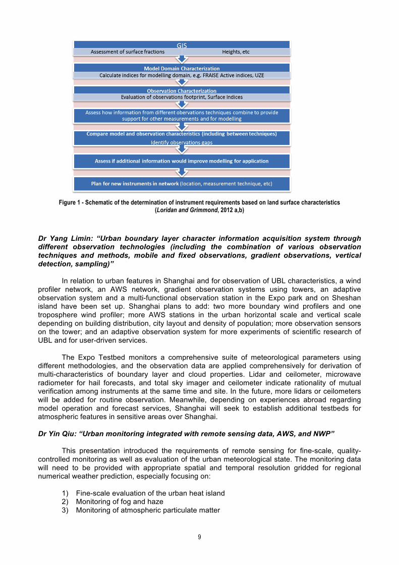


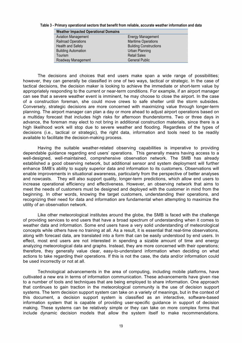


![Dessler Fhrm3 Inppt01--Gaw[Rev] Sd](https://static.documents.pub/doc/80x56/577cc38a1a28aba711965140/dessler-fhrm3-inppt01-gawrev-sd.jpg)


