104
PARIS LAND USE PLAN REGULATIONS General urban zone IMPORTANT NOTICE GENERAL PROVISIONS GENERAL URBAN ZONE KEY TO MAPS IN THE GENERAL ATLAS FIGURES

PARISLAND
USE PLAN
R E G U L A T I O N S General urban zone
IMPORTANT NOTICE
GENERAL PROVISIONS
GENERAL URBAN ZONE
KEY TO MAPS IN THE GENERAL ATLAS
FIGURES


SOMMAIRE
APPROVED BY DELIBERATION OF THE PARIS CITY COUNCIL ON 4, 5, 6 AND 7 JULY 2016
2 / PARIS LAND USE PLAN / SOMMAIRE
PARISLAND
USE PLAN
Article UG.1 - Prohibited land occupation and uses ..................................... 33
UG.1.1 - General provisions: .................. 33
UG.1.2 - Special provisions applicable in certain sectors: ..................... 33
Article UG.2 - Land occupations and uses subject to special conditions .................... 34
UG.2.1 - Land use and occupancy conditions: ............................... 34
UG.2.2 - Conditions relating to usage (see “destinations”): ................... 35
UG.2.3 - Provisions relating to perimeters to be the subject of a global development project (see “projet d’aménagement global”): .......... 39
Article UG.3 - Conditions for servicing land through public or private roads (see “voie”) and conditions for accessing roads (see “voie”) open to the public ....... 39
UG.3.1 - Service and access: .................. 39
UG.3.2 - New roads: ............................. 40
UG.3.3 - Pedestrian links and crossings to be preserved, created or modified: ... 40
Article UG.4 - Conditions of servicing land plots through the networks .................... 40
UG.4.1 - Drinking water: ........................ 40
UG.4.2 - Energy: ................................... 40
UG.4.3 - Sanitation: ............................... 40
Article UG.5 - Minimum surface area for building areas ......................................... 41
Article UG.6 - Siting of buildings in relation to the roads (see “voie”) ................ 41
UG.6.1 - General provisions: .................. 41
UG.6.2 - Land with a Maximum building footprint (see “emprise constructible maximale”) instruction: .............. 41
UG.6.3 - Special provisions applicable in certain sectors: ..................... 42
Article UG.7 - Siting of buildings in relation to the separating boundaries ........ 44
UG.7.1 - General provisions: .................. 44
UG.7.2 - Communal courtyard and contractual siting easement: ....... 45
IMPORTANT NOTICE ..................................... 5
I - Legal basis of the regulations........................... 7
II - Territorial scope of application ......................... 7
III - Effects of the regulations ................................. 7
IV - Structure of the PLU regulations ........................ 7
IV-1- Written documents : .............................. 8
IV-2- Graphic documents: .............................. 8
V - Regulatory links with the other documents comprising the Paris Land Use Plan (PLU) .......... 9
VI - Legislative and regulatory texts to be observed ............................................ 10
VII - Provisions relating to works and operations ..... 11
VII-1- System of regulations resulting from the Ordinance 2005-1527 of 8 December 2005 (in accordance with the regulations in effect in September 2008): ............... 11
VII-2- Schemes covered by other texts (authorisations, declarations, instructions, notices, etc.): ...................................... 12
GENERAL PROVISIONS APPLICABLE TO THE AREA COVERED BY THE PARIS LAND USE PLAN (PLAN LOCAL D’URBANISME - PLU) ................................. 15
I - Division of the area into urban zones and natural zones ........................................ 17
II - Delimitation of sectors subject to special provisions ................................................... 17
III - Protected wooded areas ............................... 17
IV - Regulatory status of roads ............................. 17
V - Minor adjustments ........................................ 18
VI - Application of the regulations to existing buildings ..................................... 18
VII - Application of the regulations to subdivision .... 19
VIII - Definitions ................................................... 19
GENERAL URBAN ZONE ........................... 31
Character of the general urban zone (UG) ............ 33

PARISLAND
USE PLANAPPROVED BY DELIBERATION OF THE PARIS CITY COUNCIL ON 4, 5, 6 AND 7 JULY 2016
SOMMAIRE / PARIS LAND USE PLAN / 3
constructions basses en bordure de voie” - ECB): ........................ 69
Article UG.12 - Obligations imposed on builders in relation to the construction of parking areas ............................. 69
UG.12.1 - Parking of motor vehicles: .......... 69
UG.12.2 - Delivery areas and drop-off areas for coaches: ............................. 70
UG.12.3 - Parking of bicycles and pushchairs: ........................ 71
Article UG.13 - Open spaces (see “espaces libres”) and planted areas, greening of buildings .................................... 72
UG.13.1 - Obligations regarding the creation of open spaces (see “espaces libres”), planted areas and frame landscaping: ............................ 72
UG.13.2 - Planted areas: .......................... 76
UG.13.3 - Localised provisions: ................. 77
Article UG.14 - Density Rules ............................... 79
Article UG.15 - Energy and environmental performance ............................... 79
UG.15.1 - Rainwater management: ............ 79
UG.15.2 - Waste collection: ...................... 80
UG.15.3 - Energy and environmental performance of buildings: .......... 80
UG.15.4 - Noise performance requirements: ....82
ZONE OF MAJOR URBAN SERVICE ............
................................................... see french version
GREEN URBAN ZONE ........... see french version
NATURAL AND FOREST ZONE ....................
................................................... see french version
FIGURES ....................................................... 83
KEY TO MAPS IN THE GENERAL ATLAS .......................... 97
UG.7.3 - Lands governed by a Maximum Building Footprint (see “emprise constructible maximale”) ............ 45
UG.7.4 - Special provisions applicable in certain sectors: ..................... 45
Article UG.8 - Siting of buildings in relation to each other on the same land ..... 46
UG.8.1 - General provisions: .................. 46
UG.8.2 - Lands governed by a Maximum Building Footprint (see “emprise constructible maximale”): ........... 46
UG.8.3 - Special provisions applicable in certain sectors: ..................... 47
Article UG.9 - Building footprints (see “emprise au sol des constructions”) ............. 47
UG.9.1 - Lands governed by a Maximum Building Footprint (see “emprise constructible maximale” - ECM): ................................... 47
UG.9.2 - Special provisions applicable in certain sectors: ..................... 47
Article UG.10 - Maximum height of buildings ........ 47
UG.10.1 - Ceiling heights: ........................ 47
UG.10.2 - Template-envelope at the road edge: ...................................... 50
UG.10.3 - Template-envelope (see “gabarit-enveloppe”) in separating boundaries: ............................. 54
UG.10.4 - Template-envelopes of buildings facing each other on the same land: ....................................... 56
Article UG.11 - External Appearance of Buildings and Development of their Surroundings, Protection of buildings and landscape Elements ............... 57
UG.11.1 - General provisions: .................. 57
UG.11.2 - Projections (see “saillie”) of building components: ............ 62
UG.11.3 - Projections (see “saillie”) on roads or public spaces of urban development works attached to buildings: ...... 65
UG.11.4 - Fences: ................................... 66
UG.11.5 - Protection of urban structures and architectural heritage: ......... 67
UG.11.6 - Footprint of low-rise roadside buildings (see “emprise de


IMPORTANT NOTICE


PARISLAND
USE PLANAPPROVED BY DELIBERATION OF THE PARIS CITY COUNCIL ON 4, 5, 6 AND 7 JULY 2016
IMPORTANT NOTICE / PARIS LAND USE PLAN / 7
I - LEGAL BASIS OF THE REGULATIONSThe provisions of these regulations are established pursuant to the French Code de l’urbanisme (Town Planning Code), and in particular articles L.151-1 to L.151-42 and R.123-1 to R.123-12. In accordance with Article R.111-1 of the French Code de l’urbanisme (Town Planning Code), articles R.111-2, R.111-4 and R.111-20 to R.111-27 of the National Urban Planning Regulations (second part, book 1, title 1, chapter 1 of the French Code de l’urbanisme (Town Planning Code) are applicable in the area covered by the PLU.
The references to the legislative provisions of the French Code de l’urbanisme (Town Planning Code) contained in the constituent documents of this PLU refer to the version of this code in force on the date of approval of the PLU.
Pursuant to Article 12 of Decree No. 2015-1783 of 28 December 2015 relating to the regulatory part of book 1 of the French Code de l’urbanisme (Town Planning Code) and to the modernisation of the content of the land use plan, articles R.123-1 to R.123-14 of the French Code de l’urbanisme (Town Planning Code) in their current wording as of 31 December 2015 remain applicable and are referred to in this PLU.
The French Code de l’urbanisme (Town Planning Code) is available for consultation in its current version and in the consolidated version as of 31 December 2015, on the legifrance.gouv.fr website.
II - TERRITORIAL SCOPE OF APPLICATIONThe regulations apply to the area of the City of Paris with the exception of:
the protected areas of the Marais and the 7th arrondissement, respectively governed by the Marais P reservation and Enhancement Plans approved by an inter-ministerial decree of 23 August 1996 (parts of the 3rd and 4th arrondissements) and revised by the Prefectoral Order of 18 December 2013, and the 7th arrondissement Preservation
and Enhancement Plans approved by an inter-ministerial decree of 26 July 1991 (part of the 7th arrondissement);
The perimeter corresponding to the Jardin du Luxembourg heritage site covered by Article 76 of Law No. 2003-590 of 2 July 2003 relating to urban planning and housing.
III - EFFECTS OF THE REGULATIONSThese regulations set out, in conformity with the Planning and Sustainable Development Project of the PLU, the general rules and easements of land use that are designed to enable Paris to achieve the objectives established by Article L.101-2 of the French Code de l’urbanisme (Town Planning Code).
In accordance with Article L.152-1 of the French Code de l’urbanisme (Town Planning Code), the execution by any public or private person of any works, constructions, installations, planting, scouring or raising of soils, and opening of classified installations belonging to the categories defined in the plan are in conformity with the regulations and its graphic documents. Furthermore, these works or operations are also compatible with the planning and programming guidelines whenever applicable.
The PLU can also be binding in the event of any occupation or use of a land, even when it is not subject to authorisation or declaration, with the exception of some buildings, developments, installations and works, due to the short duration of their existence or their temporary nature (Article L.421-5 of the French Code de l’urbanisme (Town Planning Code).
IV - STRUCTURE OF THE PLU REGULATIONSIn accordance with the provisions of the French Code de l’urbanisme (Town Planning Code), and in particular with articles R.123-4 to R.123-12, the PLU regulations include:

APPROVED BY DELIBERATION OF THE PARIS CITY COUNCIL ON 4, 5, 6 AND 7 JULY 2016
8 / PARIS LAND USE PLAN / IMPORTANT NOTICE
PARISLAND
USE PLAN
IV-1- Written documents :
The regulations include :
VOLUME 1:
The general provisions applicable to the area covered by the PLU, which establish the zonal divisions of the area covered by the PLU and set out various principles established in the regulatory documents (delimitation of sectors subject to specific provisions, protected wooded areas, regulatory status of roads, minor adjustments to the rules, application of the rules to existing buildings). These provisions also set out (§ VIII) the definition of the terms used in the regulatory provisions, when it is necessary to understand and interpret the said provisions without ambiguity. The words which have been defined are marked with an asterisk in the main body of the regulations.
The rules applicable in the 4 zones of the PLU – UG, UGSU, UV and N consecutively – are organised into 15 articles per zone in accordance with Article R.123-9 of the French Code de l’urbanisme (Town Planning Code). Some of the rules applicable in UG and UGSU are illustrated by figures inserted at the end of these regulations.
VOLUME 2:
Appendix I: list of the sectors subject to special provisions, indicating the articles of the regulation concerned,
Appendix II: list of perimeters to be the subject of a global development project (Article L.151-41 §5° of the French Code de l�urbanisme [Town Planning Code]), with an indication of the maximum building surfaces and the duration of these easements,
Appendix III: list of reserved locations for roads, public works, general interest installations, green spaces (Article L.151-41 §1° to 3° of the French Code de l’urbanisme [Town Planning Code]), with the indication of their addresses, beneficiaries and usage,
Appendix IV: list of the location perimeters for public roads and public works, general interest installations and green spaces to be created or modified (articles L.151-41 and R.123-12 §4° d) of the French Code de l’urbanisme [Town Planning Code]) registered for the benefit of the City of Paris, indicating the addresses of the plots concerned and the usage of the planned facilities,
Appendix V: list of reserved locations for the creation of housing and social or mid-market rent housing (Article L.151-41 §4° of the French Code de l’urbanisme [Town Planning Code]) registered for the benefit of the City of Paris, indicating their addresses and the type of reservations applicable,
Appendix VI: list of heritage protections (Article L.151-19 of the French Code de l’urbanisme [Town Planning Code]) which lists the buildings (plots, buildings, parts of buildings, specific elements) protected by the PLU, while indicating descriptive elements,
Appendix VII: list of Protected Green Spaces (Espace vert protégé E.V.P.) (articles L.151-19 and L.151-23, paragraph 1 of the French Code de l’urbanisme [Town Planning Code]), indicating the addresses of the plots concerned and the surface areas of the said areas, in full and per plot.
IV-2- Graphic documents:
The graphic documents of the regulations include:
The general atlas, which is composed of the following documents:
the summary map of the thematic sectorisation of the area covered by the PLU,
the key of the sections at 1/2000 to 1/5000,
the assembled chart of the sections at 1/2000,
the zoning plan, demarcating the N natural and forest zone and the 3 UG, UGSU and UV urban zones,

PARISLAND
USE PLANAPPROVED BY DELIBERATION OF THE PARIS CITY COUNCIL ON 4, 5, 6 AND 7 JULY 2016
IMPORTANT NOTICE / PARIS LAND USE PLAN / 9
the “balance between usages and parking restrictions” plan, presented in 4 sections, indicating the boundaries of the sectors defined for the application of the provisions of Article 2.2.1 of the UG zone and the provisions of Article 12 of the UG, UGSU and UV zones;
the “social diversity” and “retail businesses and craft trades protection plan”, presented in 4 sections, demarcating the zone with a social housing deficit (Article UG.2.2.3), the zone without a social housing deficit (Article UG.2.2.4) and the protected zone for retail businesses and craft trades,
the general height plan, indicating the ceiling heights fixed for the application of Article 10 of the regulations,
the Paris vista protection spindles, presented in 4 sections, indicating the protection areas for panoramic views, partial views and restricted views, regulations which are more restrictive than the ceiling heights (Article 10 of the regulations),
the at-risk sectors plans, demarcating the sectors in which the PLU regulations apply specific provisions to prevent natural risks
sections at 1/2000 (1/5000 for the Bois de Boulogne and Bois de Vincennes), which locate the prescriptions or easements on the plots of land;
The atlas of the detailed plans, which include:
the assembled chart of the sections of the Maisons and Villas Sectors (see “secteurs de maisons et villas”),
the list of the Maisons and Villas Sectors sections,
the key of the Maisons and Villas Sectors.
the 1/1000 sections specifying and completing the provisions of the 1/2000 sections in the Maisons and Villas Sectors
the key of the block sections of the Montmartre sector,
the numbering of the block sections of the Montmartre sector,
the Montmartre block sections indicating the provisions of Article UG.10 specific to this sector.
V - REGULATORY LINKS WITH THE OTHER DOCUMENTS COMPRISING THE PARIS LAND USE PLAN (PLU)The provisions of the regulations are established in direct application of the general planning and urban planning guidelines laid down by the Planning and Sustainable Development Project (Plan d�aménagement et de développement durable P.A.D.D.) for the whole area covered by the PLU, and in accordance with the planning and programming guidelines that the document defines for some sectors.
Their content and expected effects are motivated by the comments in the third part of the PLU presentation report, which also sets out the reasons behind the changes made to the pre-existing provisions of the urban planning document.
The provisions of the regulations respect the public utility easements applicable in the Paris area, which are outlined in the appendices to the PLU (Historic Monuments, Plan for the Prevention of Risks of Ground Movement, Flood Risk Prevention Plan, etc.).
These appendices also include information documents for the users of the PLU, namely:
the delimitation of the perimeters instituted to implement specific measures (PSMV, ZAC, “enhanced” right of first refusal, possibility of deferring decisions on applications for authorisation to undertake works, comprehensive development programmes, etc.),
texts and plans resulting from specific legislation that are applied independently of the provisions of the PLU (Paris-Issy-les-Moulineaux Heliport Noise Exposure Plan, acts establishing restricted advertising

APPROVED BY DELIBERATION OF THE PARIS CITY COUNCIL ON 4, 5, 6 AND 7 JULY 2016
10 / PARIS LAND USE PLAN / IMPORTANT NOTICE
PARISLAND
USE PLAN
zones and expanded advertising zones, Plan for the Prevention of Risks of Ground Movement, Flood Risk Prevention Plan, etc.),
Various plans and texts for further information.
VI - LEGISLATIVE AND REGULATORY TEXTS TO BE OBSERVED
The provisions of the regulations apply without prejudice to the application of the laws, regulations, documents, easements and prescriptions pertaining to urban planning. In particular, users of the regulations must respect the following texts:
Public utility easements affecting land use and occupation, established under various laws and legislation and listed in the appendices to the PLU (list of easements and related plans), according to the following classification:
I - Easements relating to the conservation of heritage, and in particular cultural heritage - historic monuments, natural monuments and sites: buildings classified as historic monuments are excluded from the scope of other legal easements when they may cause the deterioration of the said buildings (Article L.621-16 of the Heritage Code);
II - Easements relating to the use of certain resources and facilities (including energy, pipelines, communications, telecommunications); these easements include alignment easements which are indicated on the graphic documents included in the regulations;
III - Easements relating to national defence;
IV - Public health and safety easements, which include:
The Flood Risk Prevention Plan (P.P.R.I.) of the Paris Department, approved by the Prefectoral Order of 15 July 2003
and amended by the Prefectoral Order of 19 April 2007;
Inter-prefectoral orders validating the Plan for the Prevention of Risks of Ground Movement in accordance with Act No. 95-101 of 2 February 1995 and Decree No. 95-1089 of 5 October 1995: orders of 26 January 1966, 25 February 1977 and 19 March 1991;
Perimeters instituted by prefectoral orders in which the execution of works subject to building permits is regulated or prohibited in consideration of the risks presented by installations classified to protect the environment, in accordance with articles L.515-8 et seq. of the French Code de l’environnement (Environmental Code).
The Paris-Issy-les-Moulineaux Heliport Noise Exposure Plan (Plan d’exposition au bruit – P.E.B.), established in accordance with Article L.112-6 of the French Code de l’urbanisme (Town Planning Code) and approved by the Inter-Prefectoral Order of 24 March 1997 and amended by the Inter-Prefectoral Order of 18 April 2007;
The Paris Department’s Health Regulations, established in accordance with articles L.1311-1 and L.1311-2 of the French Code de la santé publique (Public Health Code);
The Paris sanitation regulations approved by the Paris City Council on 11 and 12 February 2013;
Preventive fire protection measures in workshops and warehouses located inside residential buildings in the city of Paris, implemented by Order No. 2013-00789 of 15 July 2013 issued by the Paris Police Commissioner;
The emergency measures against lead poisoning provided for in Article L.32-5 of the Public Health Code in accordance with the Order of the Paris Prefect of 24 October 2000 classifying the entire Paris area as an area at risk of lead exposure with regard to building coatings.

PARISLAND
USE PLANAPPROVED BY DELIBERATION OF THE PARIS CITY COUNCIL ON 4, 5, 6 AND 7 JULY 2016
IMPORTANT NOTICE / PARIS LAND USE PLAN / 11
The preventive measures to protect against termites in new buildings provided for in articles R.112-2 to R.112-4 of the French Code de la construction et de l’habitation (Building and Housing Code), applicable throughout the Paris Department.
The Prefectoral Order of 21 March 2003 establishing a termite monitoring and control zone throughout the Paris Department, which stipulates that in the event of partial or total demolition of a building, wood and other materials contaminated by termites must be incinerated on-site, or treated prior to being transported if their destruction by on-site incineration is not possible. The person who carries out these operations is responsible for notifying the arrondissement Town Hall of the same.
Act No. 85.729 of 18 July 1985 concerning the definition and implementation of the development principles stipulates, particularly in article 42 (§ IV) that, in the zone formerly subject to military easements established around the fortified enclosure of the Paris area, the installation of buildings may not cover a total surface area exceeding 20% of the total area of this zone.
In addition, various public and private easements established under the Civil Code are applicable, particularly rights-of-way on private land, common courtyard easements and rights of view instituted between owners, non-aedificandi and non altius-tollendi easements, particularly frequent in the Houses and Villas Sectors (S.L.).
VII - PROVISIONS RELATING TO WORKS AND OPERATIONS
VII-1- System of regulations resulting from the Ordinance 2005-1527 of 8 December 2005 (in accordance with the regulations in effect in September 2008):
Ordinance 2005-1527 of 8 December 2005 and Decree No. 2007-18 of 5 January 2007 significantly reformed the authorisation schemes and declarations
governed by the French Code de l’urbanisme (Town Planning Code). Eleven authorisation schemes and 5 declarations were merged into 3 permits (construction, development, demolition) and a prior declaration.
Operations which are exempt from permits or prior declaration on the basis of an authorisation determined by other legislation were also specified (articles L.421-5 § d and R.425-23 to R.425-29-1). This concerns in particular:
Construction projects on a building classified as a Historic Monument;
Underground gas, fluid or waste storage projects;
Soil scouring or soil heightening projects;
Advertising, signage and indications projects.
a - New Constructions:
New constructions, even those without foundations, are subject to building permits (Article L.421-1).
However, some new constructions are exempt from all formalities under the French Code de l’urbanisme (Town Planning Code) (articles R.421-2 to R.421-8-2).
Certain new constructions must be preceded by a prior declaration (articles R.421-9 to R.421-12). In addition, throughout the Paris area, boundary fences are subject to prior declaration in accordance with the deliberation 2007 DU 94 of 25 and 26 June 2007 of the Paris City Council.
b - Works on existing buildings and changes in the usage of buildings:
Work on existing buildings is in principle exempt from all formalities under the French Code de l’urbanisme (Town Planning Code) (articles L.421-1, second paragraph and R.421-13).
However, certain works are subject to a building permit (articles R.421-14 to R.421-16) or to a prior declaration (Article R.421-17).

APPROVED BY DELIBERATION OF THE PARIS CITY COUNCIL ON 4, 5, 6 AND 7 JULY 2016
12 / PARIS LAND USE PLAN / IMPORTANT NOTICE
PARISLAND
USE PLAN
c - Works, installations and developments affecting land use:
Works, installations and developments affecting land use are in principle exempt from formalities (articles L.421-2 and R.421-18).
However, certain works are subject to a development permit (articles R.421-19 to R.421-22) or to a prior declaration (articles R.421-23 to R.421-25).
d - Demolition:
The demolition of existing buildings must be preceded by the issuance of a demolition permit, pursuant to deliberation 2007 DU 94 of 25 and 26 June 2007 (article L.421-3).
However, the works mentioned in Article R. 421-29 are exempt from demolition permits.
VII-2- Schemes covered by other texts (authorisations, declarations, instructions, notices, etc.):
a - Other schemes provided for by the French Code de l’urbanisme (Town Planning Code):
Pursuant to Article L.424-1 of the French Code de l’urbanisme (Town Planning Code), the competent authority may defer making a decision on permit applications for works, constructions or installations likely to jeopardise or render more onerous the execution of public works or the execution of a development operation, provided that the study of a public works project or the development operation has been taken into consideration by the municipal council or the prefect of the department.
In application of Article L.113-2 paragraph 2, the classification of wooded areas leads to the automatic rejection of applications for a clearance authorisation.
In application of Article L.410-1, within eighteen months of the issue of an urban planning certificate, the urban planning provisions, the urban planning
taxes and contributions system and the administrative restrictions to the right of ownership such as they existed at the date of the certificate may not be called into question.
Pursuant to Article L.510-1, in the Ile-de-France region, the construction, reconstruction, or extension of premises or facilities or their extensions used for industrial, commercial, professional, administrative, technical, scientific or educational activities outside the jurisdiction of the State and its control are subject to the approval procedure of the administrative authority.
The change of user or use of these premises may be subject to approval by the administrative authority.
b - Schemes provided for by the French Code de l’environnement (Environmental Code):
In application of articles L.214-1 to L.241-6, installations, works, and activities involving water withdrawals or discharges (defined by the nomenclature in Article R. 214-1) or likely to pose a danger to public health and safety, interfere with the free flow of water, reduce its resource, increase the risk of flooding, or impair the quality and diversity of the aquatic environment are subject to authorisation or declaration.
Pursuant to Article L.341-10, all works likely to modify the condition or appearance of a classified site (and in particular the cutting and felling of trees and plantations) is subject to special authorisation by the Minister in charge of classified sites or by the Paris Prefect.
Pursuant to Article L.341-1, all construction work on registered sites is subject to prior declaration, with the exception of ordinary building maintenance work.
Pursuant to articles L.511-1 et seq., installations listed for environmental protection shall be subject to declaration, registration or authorisation.
Works planned in the vicinity of certain underground, aerial or underwater transport or distribution structures (hydrocarbons, gas, electricity, telecommunications,

PARISLAND
USE PLANAPPROVED BY DELIBERATION OF THE PARIS CITY COUNCIL ON 4, 5, 6 AND 7 JULY 2016
IMPORTANT NOTICE / PARIS LAND USE PLAN / 13
sanitation, drinking water and its reservoirs, steam, guided public transport, etc.) are required to make a declaration of the works project with the operators concerned during the project planning phase and are required to make a declaration of intention to start work with the said operators, in application of articles R.554-20 et seq. of the Environmental Code. Where such work is carried out in the vicinity of gas or hydrocarbon transport pipelines, particularly in the areas listed in the addendum to the appendices to the PLU, the relevant planning authorisations shall be appraised on the basis of the information provided to the person responsible for the project by the operator or operators concerned in accordance with Article R.554.22 of the Environmental Code, and in accordance with:
Circular no. 2006-64 of 4 August 2006, which is based on the Order of 29 September 2005 relating to the evaluation and consideration of the probability of occurrence, of kinetics, the intensity of effects and the severity of the consequences of potential accidents in the hazard studies for classified facilities subject to authorisation;
The Order of 5 March 2014 defining the procedures for implementing Chapter V of Title V of Book V of the Environment Code and regulating the safety of pipelines for the transport of natural or assimilated gas, hydrocarbons and chemical products, in particular Article 29 relating to the control of urbanisation.
c - Schemes planned under other codes:
Pursuant to Article L.621-31 of the French Code du patrimoine (Heritage Code), any new construction, demolition, deforestation or clearing, transformation or modification likely to affect the aspect of a building situated within the visibility of a building classified or listed as a historic monument, as defined in Article L.621-30, is subject to prior authorisation. The building permit shall serve as said authorisation when it is endorsed by a Bâtiments de France architect.
Pursuant to Article L.631-7 of the French Code de la construction et de l’habitation (Building and Housing Code), the change of use of premises intended for
residential use is subject to prior authorisation.
Pursuant to articles L.750-1 and L.752-1 of the French Code de commerce (commercial code) and Article L.212-7 of the French Code du cinéma et de l’image animée (Film and Moving Image Code), the establishment, extension and transfer of existing activities and the change in the sector of activity of business enterprises, the creation and extension of hotel establishments, as well as the creation and extension of cinemas is subject to authorisation when they exceed certain thresholds.
In accordance with Article L.312-3 of the French Code du sport (Sports Code), the total or partial elimination of a private sports facility whose financing has been provided for at least partially by a legal entity governed by public law, and the modification of its use, is subject to the authorisation of the legal entity having participated in this financing. The Mayor’s opinion is attached to the application. The authorisation is subject to the condition that this facility be replaced by an equivalent sporting facility.
In accordance with articles L. 341-3 et seq. of the French code forestier (Forestry Code), clearing activities are subject to authorisation in unclassified wooded areas.
d - Schemes planned under other texts:
Pursuant to articles 2 and 3 of Ordinance 45-2339 of 13 October 1945 relating to performances or shows amended by Act 99-198 of 18 March 1999, the construction of performance halls is subject to declaration to the Minister of Culture and the Paris police commission.
The change of use, demolition of theatres and concert halls, as well as the building leases, rentals, sub-leases or transfers of the business of entertainment companies are subject to ministerial authorisation.
In application of the inter-prefectoral orders of 26 January 1966, 25 February 1977 and 19 March 1991, which constitute a Prevention Plan for the Risks of ground Movement in accordance with Article L.562-6 of the Environmental Code, the construction

APPROVED BY DELIBERATION OF THE PARIS CITY COUNCIL ON 4, 5, 6 AND 7 JULY 2016
14 / PARIS LAND USE PLAN / IMPORTANT NOTICE
PARISLAND
USE PLAN
of buildings or installations, as well as the erection, extension or modification of existing buildings in areas of old underground quarries, as well as in areas containing pockets of antediluvian gypsum, are subject to the special conditions defined by the General Inspectorate of Quarries (1, place Denfert-Rochereau 75014 Paris), with a view to ensuring the stability of the projected constructions and to prevent any risk of landslides or subsidence (see appendices to the PLU list of easements, § IV B: easements relating to public safety).
Occupying the public road domain of the Paris municipality is subject to authorisation, in accordance with the French Code de la voirie routière (Roadway Code) and the Road Regulations established for its application.
Those involved in construction and the professions concerned are invited to refer to the provisions contained in the Environmental Guidelines Booklet issued by the City of Paris.
In accordance with Order no. 2005-984 of 16 May 2005 of the Prefect of the Ile de France region, Paris Prefect, defining zones and footprint thresholds in the Paris area for certain works that are likely to be subject to preventive archaeological measures, the works covered by this Order may be undertaken only after consultation with the Regional Directorate for Cultural Affairs and, where appropriate, the accomplishment of preventive archaeological measures, in accordance with Article L.522-5 of the French Code du patrimoine (Heritage Code) (second paragraph).
GENERAL PROVISIONS APPLICABLE TO THE AREA COVERED BY THE PARIS LAND USE PLAN (PLAN LOCAL D’URBANISME - PLU)


PARISLAND
USE PLANAPPROVED BY DELIBERATION OF THE PARIS CITY COUNCIL ON 4, 5, 6 AND 7 JULY 2016
GENERAL PROVISIONS / PARIS LAND USE PLAN / 17
delimit, in accordance with the key, the protected wooded areas in which the provisions of articles L.113-1 et seq. of the French Code de l’urbanisme (Town Planning Code) apply.
IV - REGULATORY STATUS OF ROADS
The following shall be considered as roads for the application of articles 3, 4, 6, 7, 8, 10, 12 and 13 of the urban zones regulations:
a - any public or private road identified in the graphic documents of the regulations, with the exception of public road rights-of-way, where the principle of decommissioning has been retained;
b - any roads to be created which are covered by one of the following requirements in the graphic documents included in the regulations:
Site reserved for the widening or creation of communal public roads, Site perimeter for public facilities, works, green space or general interest installation to be carried out, Road to be preserved, modified or created;
c - any road or pedestrian road to be created or modified as indicated in the graphic documents included in the planning and programming guidelines,
d - any public road whose creation has been decided by deliberation of the Paris City Council,
e - any road created or to be created within the framework of a subdivision authorisation.
Pedestrian links indicated in the graphic documents included in the regulations are not considered as roads.
Except for those covered by the N zone; the roads are attached to the UG zone.
Underground construction may be allowed beneath roads, in compliance with the provisions of articles UG.1 and UG.2.
I - DIVISION OF THE AREA INTO URBAN ZONES AND NATURAL ZONES
The area of Paris covered by the PLU is divided into three urban zones and one natural zone1:a - the general urban zone (UG zone),b - the zone of major urban services (UGSU zone), c - the green urban zone (UV zone),d - the natural and forest zone (N zone).
II - DELIMITATION OF SECTORS SUBJECT TO SPECIAL PROVISIONSThe graphic documents included in the regulations delimit sectors which are subject to special provisions, i.e., for their part covered by the UG zone.
Appendix I to Volume 2 of the present regulations contains references to the special provisions applicable in each of these sectors.
In the Montmartre sector, the special graphic provisions set out in the “planches d’îlots du secteur Montmartre” (block sections of the Montmartre sector) in the atlas with the detailed maps apply pursuant to Article UG.10.
The graphic documents included in the regulations delimit the Roland Garros sector, which is subject to special provisions in the UV zone regulations (in the case of articles UV.2.3, UV.6, UV.7 and UV.10.2).
The graphic documents included in the regulations delimit the Grand Parc sector (the Porte de Versailles Exhibition Centre) and the Petite Ceinture sector (footprint of the petite ceinture or ‘small belt’ railway line) subject to special provisions in the UGSU zone regulations (in the case of article UGSU.2.2).
III - PROTECTED WOODED AREAS
The graphic documents included in the regulations
1 Only the general urban zone regulations are translated (see cover)

APPROVED BY DELIBERATION OF THE PARIS CITY COUNCIL ON 4, 5, 6 AND 7 JULY 2016
18 / PARIS LAND USE PLAN / GENERAL PROVISIONS
PARISLAND
USE PLAN
However, the following may be allowed for all types of constructions:
works aimed exclusively at ensuring that buildings comply with accessibility, hygiene, soundproofing, thermal insulation or safety standards, whether or not they comply with articles 6, 7, 8, 9, 10, UG.11.2, UGSU.11.2, UG.11.3, UGSU.11.3, 12, 13;
work to improve energy performance or to develop the production of renewable energy in buildings, whether or not they comply with articles 6, 7, 8, 9, 12 or 13.
With regard to the restoration or reconstruction of buildings protected as historic monuments, exemptions to the rules of the PLU may be granted: based on a reasoned decision, by the authority in charge of issuing planning authorisations, all in accordance with the provisions of Article L.152-4 §2° of the French Code de l’urbanisme (Town Planning Code).
In accordance with Article L.111-15 of the French Code de l’urbanisme (Town Planning Code), the identical reconstruction of a building that does not comply with the provisions of the PLU is not permitted unless, although regularly erected, it has been destroyed by an accident or disaster in less than ten years.
In zone N, any reconstruction of buildings regularly erected and destroyed by disasters in the last ten years shall be subject to the conditions laid down in Article N. 2.1 § i.
2°- SPECIAL PROVISIONS
Work may also be authorised in the sectors covered by the development guidelines listed below to improve the housing conditions (see “conditions d’habitabilité”) of existing residential buildings, whether or not they comply with articles UG.6, UG.7, UG.8, UG.10, UG.11.2, UG.11.3, UG.13. The sectors concerned are the following sectors, subject to special provisions and indicated in the graphic documents: Olympiades - Villa d’Este - Place de Vénétie - Tolbiac, Plaisance - Porte de Vanves, Beaugrenelle - Front de Seine, Porte Pouchet, Porte de Saint-Ouen, Porte de Montmartre - Porte de Clignancourt - Porte des Poissonniers, Cité Michelet, Saint-Blaise.
Constructions can be permitted to hang over a road:
exceptionally as part of an overall architectural project, for a structure or part of a building connecting two buildings bordering the said road,
in the case of a construction spanning or overlooking the Boulevard Périphérique or its slip roads.
High-rise buildings are permitted on streets:
in the Low-rise building footprints (see “emprise de constructions basses” - E.C.B.) indicated in the graphic documents included in the regulations (see Article UG.11.6),
for temporary construction site installations, marketing or exhibition installations,
for any construction authorised under a public area occupation permit or agreement issued by the City of Paris.
V - MINOR ADJUSTMENTS
In accordance with Article L.152-3 of the French Code de l’urbanisme (Town Planning Code), the rules and easements defined by the PLU may be subject to minor adjustments due to the nature of the ground, the configuration of the plots or the type of neighbouring buildings.
VI - APPLICATION OF THE REGULATIONS TO EXISTING BUILDINGS
1°- GENERAL PROVISIONS
Where an existing construction does not comply with the provisions applicable in the zone in which it is located, authorisation to carry out work may only be granted for work that does not aggravate the construction’s non-conformity with these provisions, or which has no effect in relation to them.

PARISLAND
USE PLANAPPROVED BY DELIBERATION OF THE PARIS CITY COUNCIL ON 4, 5, 6 AND 7 JULY 2016
GENERAL PROVISIONS / PARIS LAND USE PLAN / 19
with the provisions of articles 7 and 8 (width of view, prospect) and 10 (template-envelope). (See also Figure 4 following the zone regulations)
Bande E (E band) (articles UG.7, UG.10, UGSU.7, UGSU.10):
E band is a system that favours the maintenance of roadside building continuity in the UG and UGSU zones.
In the E band constructions must in principle be located within the lateral dividing boundaries of the land considered to be leading to the alignment of the roads (articles UG.7 and UGSU.7). The E band also determines the area in which the building template-envelope (see “gabarit-enveloppe”) defined at the border of roads (see “voie”) applies (articles UG. 10 and UGSU. 10).
The width of the E band is set at 20 metres, measured from:
the alignment of the public road or the de facto boundary of the private road,
where applicable, the alignment projected by an alignment easement or reserved location for lane creation or road widening,
where applicable, the line at the edge of the road (see articles UG.10.2 and UGSU. 10.2) or at the edge of the open space to be landscaped (ELV) bordering the road.
(See Figures 1 and 2 at the end of these regulations)
The E band does not apply to:
the border of the Boulevard Périphérique and its slip roads,
land in the UG zone, which, in the graphic documents included in the regulations, are subject to the maximum building footprints (see “emprise constructible maximale” - E.C.M.).
Bande Z (Z band) (article UG.13)
The Z band is included in calculations of the minimum area of open spaces (Article UG. 13).
VII - APPLICATION OF THE REGULATIONS TO SUBDIVISIONIn a subdivision, the articles of the regulations apply individually to each batch, with the exception of articles UG.2.2.3, UG.2.2.4, UG.4, UG.15.1, UG.15.2, UGSU.4, UGSU.15.1 and UGSU.15.2.
VIII - DEFINITIONS
These definitions shall be taken into account for the application of the present regulations and the graphic documents included.
Alignement (alignement) (Article 6):
Alignment is the delineation of a public road at the interface with the adjacent properties.
Aménagement piétonnier (pedestrian planning):
Pursuant to Article L.151-38 of the French Code de l’urbanisme (Town Planning Code), the graphic documents included in the regulations indicate, in accordance with the key, road spaces intended to be developed for pedestrians. This indication does not preclude access by bicycles and public service vehicles or public interest vehicles required to service the site.
Atrium: See cour couverte (covered courtyard)
Baies constituant l’éclairement premier de sources principales (windows constituting the primary light source of main rooms) (UG and UGSU zones, articles 7, 8, 10):
A main room must have at least one window constituting its primary light source, which satisfies the following three conditions:
a- having a sill height of not more than 1.20 metres,
b- having the largest daylight area, if the room has other windows,
c- having a light-providing capacity in accordance

APPROVED BY DELIBERATION OF THE PARIS CITY COUNCIL ON 4, 5, 6 AND 7 JULY 2016
20 / PARIS LAND USE PLAN / GENERAL PROVISIONS
PARISLAND
USE PLAN
The width of the Z band is set at 15 metres, measured from:
the alignment of the public road or the de facto boundary of the private road,
where applicable, the alignment projected by an alignment easement or reserved location for road creation or widening,
where applicable, the line at the edge of the road (see Article UG.10.2) or at the edge of the open space to be landscaped (ELV) bordering the road,
where applicable, the boundary of the public green space directly bordering the land; these only concern public green spaces with more than 5,000 square metres of existing open ground or to be created, including those indicated in PLU documents as reserved locations for public green spaces or, in the planning and programming guidelines, as public green spaces to be created or modified; the definition of the Z band does not preclude the application of articles UG.7.1 and UG.10.3.
Where applicable, the Z band also includes parts of land spanning or overhanging a road or railway line.(See Figures 1 and 2 at the end of the present regulations)
The Z band does not apply to:
the border of the Boulevard Périphérique and its slip roads,
on land in the UG zone subject to, in the graphic documents included in the regulations, one or more prescriptions of the Maximum Building Footprints (see “emprises constructibles maximales” - E.C.M.).
Bâtiment protégé, élément particulier protégé (protected building, special protected element) (Article 11):
The PLU protects, pursuant to Article L.151-19 of the French Code de l’urbanisme (Town Planning Code), buildings (plots, buildings or parts of buildings, specific
elements) which possess a remarkable architectural quality, or which are testimony to the formation and history of the city or a district, or which by their volume provide a particular landmark in the urban landscape, or which belong to an architectural sequence that is remarkable for its homogeneity.
The list of these buildings and landscape elements is set out in Appendix VI to Volume 2 of the present regulations.
Cour couverte (covered courtyard) (articles 7, 8 and 10)
A covered courtyard is a space, situated at ground level or on the first floor, in which living or working premises are exposed to the open air (atrium, gallery, passageway, covered patio, etc.). It must be covered by a transparent material and have appropriate ventilation.
Facades or parts of facades that border a covered courtyard are subject to the provisions of articles 7 and 10.3 (facades on opposite sides of a dividing boundary) or 8 and 10.4 (facades opposite each other on the same land). Coverage of the courtyard is subject to the provisions of Article 10.1 and, as the case may be, articles 10.2 or 10.3. The area of the covered courtyard may not be accounted for while calculating the open spaces regulated by Article UG.13.
Destination des locaux (usage of premises) (articles 1, 2, 12, and 13):
For the application of the regulation, only usage corresponding to real rights or those established by law or custom will be taken into account; decisions and administrative acts stemming from legislation relative to changes in the use of premises will be taken into account among other elements.
For the purpose of determining the usage of a group of premises which, by virtue of their characteristics, form a unit of operation and are under the responsibility of the same manager, account shall be taken exclusively of the main use of such premises, subject to the special provisions set out below (office accommodation, artists’ studios, shops, warehouses, handicrafts, etc.).
PARISLAND
USE PLANAPPROVED BY DELIBERATION OF THE PARIS CITY COUNCIL ON 4, 5, 6 AND 7 JULY 2016
GENERAL PROVISIONS / PARIS LAND USE PLAN / 21
service activities relating to craft trades are carried out.To be attached to this location usage, storage facilities must not exceed 1/3 of the total floor area (see “surface de plancher”).
Industrial manufacturingThis location usage includes premises mainly used for the industrial manufacture of products.To be attached to this location usage, storage facilities must not exceed 1/3 of the total floor area (see “surface de plancher”).
WarehousesThis location usage includes storage and repackaging facilities for products and materials. Any storage premises connected with an industrial, commercial or craft activity where their size represents more than 1/3 of the total floor area (see “surface de plancher”), and more generally any premises receiving goods or materials not intended for sale to private individuals in the said premises, shall be treated as such.
CINASPIC (buildings and facilities necessary for public services or collective interest services) and Pre mises required for public services or collective interest servicesThese buildings and premises cover the following categories of use:
the supreme institutions of the State, embassies, consulates, legations, public international organisations;For the supreme institutions of the State, the following 11 institutions and large State bodies are referred to in the Constitution of 4 October 1958: la Présidence de la République (the Presidency of the Republic); le Premier Ministre (the Prime Minister); l’Assemblée Nationale (the National Assembly); le Sénat (the Senate); la Cour de Justice de la République (the Court of Justice of the Republic); le Conseil Supérieur de la Magistrature (the Supreme Council of the Judiciary); le Conseil Constitutionnel (the Constitutional Council); le Conseil d’État (the Council of State); le Conseil Économique et Social (the Economic and Social Council); la Cour de Cassation (the Court of Cassation); and la Cour des Comptes (the Court of Auditors).
HousingThis location usage includes all housing, including staff quarters and service rooms. It excludes the type of housing referred to in the definition of hotel accommodation. It includes bed and breakfast housing and housing made available occasionally in the event of the absence of their occupants in title for over a limited period. Workshops used by artists residing on site are considered to be extensions to the dwelling, provided that the floor area (see “surface de plancher”) of the dwelling is at least 50% of the floor area (see “surface de plancher”) occupied by the artists. Otherwise, they are assimilated to craft trades.For housing assigned to social housing, see Rental Social Housing.
Hotel accommodationThis location usage includes classified commercial accommodation establishments, or intended to be classified, such as hotels and tourist residences, as defined by the Order of 14 February 1986 or any text replacing it in the future. It also includes furnished rental accommodation not covered by Article L.632-1 of the French Code de la construction et de l’habitation (Building and Housing Code).
OfficesThis location usage includes premises and extensions belonging to public or private bodies or natural persons and where functions such as organisation, management, studies, design, computer work, research and development are carried out, as well as any premises not falling within the scope of the other usages mentioned under this heading.
Retail businessesThis location usage includes premises used for the sale of products and services directly accessible to customers, and their extensions (with the exception of premises used for craft trades as defined below).To be attached to this location usage, storage facilities must not exceed 1/3 of the total floor area (see “surface de plancher”)
Craft tradesThis location usage includes premises and their extensions where production, processing, repair or
APPROVED BY DELIBERATION OF THE PARIS CITY COUNCIL ON 4, 5, 6 AND 7 JULY 2016
22 / PARIS LAND USE PLAN / GENERAL PROVISIONS
PARISLAND
USE PLAN
premises allocated to municipal, departmental, regional or national public services intended primarily for the receptio n of the public;
constructions and technical installations required for the operations of emergency, fire-fighting and police services (safety, traffic, etc.);
crèches and day care nurseries; kindergarten, primary, secondary, technical or vocational schools;
academic institutions, including research premises, and higher education institutions;
judicial establishments; health care institutions: hospitals (including research facilities), clinics, health centres, short- and medium-stay centres, nursing homes, etc.;
social action establishments; the following institutions when they are financed by a loan subsidised by the State: residential homes, sheltered housing as defined in Article R. 351-55 of the French Code de la construction et de l’habitation (building and housing code) and student residences;
cultural establishments and performance halls specially equipped on a permanent basis for performing concerts, variety shows or performances of dramatic, lyrical or choreographic art;
sports facilities; places of worship; exhibition sites; buildings or technical installations specially designed for the operation of urban networks or services;
constructions and installations dedicated to the collection of waste, its separation, preparation for reuse, including the sale of the resulting products, or to the treatment of waste (recycling, sorting, composting, disposal, etc.);
premises intended to house businesses or self-employed persons as part of an employment support policy (business premises, business nurturing centres and incubators, coworking areas);
urban logistics areas, dedicated to the reception of activities related to the delivery and collection of goods, which may include short-term storage and removal by the recipient; storage and repackaging activities are only permitted if carried out temporarily or as marginal activities.
Eaux d’exhaure (drainage water) (Article 4):
Drainage water consists of all discharges from the pumping of groundwater, mainly corresponding to:
the unwatering of infiltrations in various underground constructions (car parks, the metro system, etc.),
water withdrawals for energy needs (heat pumps, air conditioning, etc.),
the unwatering of excavations (temporary excavation site discharges),
withdrawals of water for industrial needs.
Discharges of drainage water are treated as non-domestic waste water discharges.
Elément particulier protégé (special protected element):See Bâtiment protégé (protected building).
Emplacement réservé en vue de la réalisation de logement ou de logement locatif social (reserved location for the purpose of housing or social housing);
Emplacement réservé en vue de la réalisation de logement ou de logement locatif intermédiaire (reserved location for the purpose of housing or mid-market rent housing).
(Graphic documents included in the regulations, articles UG.2.2.3 § 2 and UG.2.2.4 § 2):
In accordance with articles L.151-41 §4° and R.123-12 c of the French Code de l’urbanisme (Town Planning Code), the graphic documents included in the regulations locate plots situated on land with reserved locations for the implementation of housing programmes and social housing or mid-market rent housing.
The owners of the land concerned may exercise the right to relinquishment under articles L.152-2 and L.230-1 et seq. of the French Code de l’urbanisme (Town Planning Code) by presenting themselves to the Town Planning Department of the City.

PARISLAND
USE PLANAPPROVED BY DELIBERATION OF THE PARIS CITY COUNCIL ON 4, 5, 6 AND 7 JULY 2016
GENERAL PROVISIONS / PARIS LAND USE PLAN / 23
These reserved locations are listed in Appendix V to Volume 2 of the regulations.
Emplacement réservé pour équipement public, ouvrage public ou installation d’intérêt général (Reserved location for public facilities, public works or general interest installations);
Emplacement réservé pour espace vert public (reserved location for public green space);
Emplacement réservé pour élargissement ou creation de voie publique communale (reserved location for road widening or creation of communal public roads)
In accordance with Article L.151-41 §1° to 3° of the French Code de l’urbanisme (Town Planning Code), the graphic documents included in the regulations demarcate reserved locations on land on which any construction or development other than those provided for in the urban planning document (public facilities, public works or general interest installations, public green space, public roads) is prohibited.
The owners of the land concerned may exercise the right to relinquishment under articles L.152-2 and L.230-1 et seq. of the French Code de l’urbanisme (Town Planning Code) by presenting themselves to the local authority or the public service concerned (Town Planning Department of the City).
When registered in the public domain, the implementation of these easements requires prior decommissioning.
The reserved locations for green spaces, public facilities and public works are listed in Appendix III to Volume 2 of the regulations.
Emprise au sol des constructions, coefficient d’emprise au sol (footprint of constructions, footprint coefficient) (articles UG.9 and N.9):
The footprint is the projection on a horizontal plane of the volume of the construction(s) excluding projections regulated by articles UG.11.2 and UG.11.3.
The footprint coefficient is the surface area of a building’s footprint’s ratio to the surface area of the land used as a reference.
Emprise constructible maximale (E.C.M. - maximum building footprint) (articles UG.6, UG.7, UG.8, UG.9, UG.10, UG.13)
The graphic documents included in the regulations delimit Maximum Building Footprints, in accordance with Article L.151-19 of the French Code de l’urbanisme (Town Planning Code), on plots of land or parts of plots whose urban form is to be protected because of its interest in the urban landscape.
These prescriptions, used particularly in the Houses and Villas Sectors (see “secteur de maisons et villas”) (SL), graphically determine the footprints within which any new construction must be established: they replace band E, which does not apply to the land concerned.
The E.C.M.s also indicate, where applicable, the maximum height and maximum footprint coefficient of the constructions.
The E.C.M. prescriptions are listed in the Houses and Villas Sectors (see “secteur de maisons et villas”) (SL sectors) and, where applicable, in the sectors subject to special provisions. When a plot with an E.C.M. is only partially included in a Houses and Villas Sector, the rules relating to the E.C.M. only apply in the part included.
The rules governing the maximum building footprint are set out in articles UG.6.2, UG.7.3, UG.8.2, UG.9.1, UG.10.1 § 2°, UG.10.2 (2nd and 3rd paragraphs) and UG.13.1.2 § 6°.
Emprise de constructions basses en bordure de voie (footprint of low-rise roadside buildings) (Article UG.11.6):
Pursuant to Article L.151-18 of the French Code de l’urbanisme (Town Planning Code), the graphic documents included in the regulations delimit, at the roadside, footprints where low-rise buildings can be built or preserved, in order to improve the streetscape.

APPROVED BY DELIBERATION OF THE PARIS CITY COUNCIL ON 4, 5, 6 AND 7 JULY 2016
24 / PARIS LAND USE PLAN / GENERAL PROVISIONS
PARISLAND
USE PLAN
Espace à libérer (Space to be released) (Article 13):
Spaces to be released from their buildings are demarcated on the graphic documents included in the regulations, in accordance with Article L.151-10 of the French Code de l’urbanisme (Town Planning Code), in order to improve the local urban landscape.
Espace boisé protégé (Protected wooded space) (zones N and UV, Article 13):
Protected wooded spaces indicated in the graphic documents included in the regulations are subject to the provisions of articles L.113-1 et seq. of the French Code de l’urbanisme (Town Planning Code).
Espaces libres (Open spaces) (Article 13):
Unless otherwise specified, this term refers to off-road spaces free from elevated constructions (except from agricultural production facilities and greenhouses, com-posters and bicycle parking areas) and excludes areas overhung by building elements.
In the UG zone, areas subject to easements: protected green spaces (espaces verts protégés – E.V.P.), protec-ted open spaces (espaces libres protégés – E.L.P.) or open spaces to be landscaped (espaces libres à végé-taliser – E.L.V.) shall be taken into account in the open space areas pursuant to Article UG.13.1.2 in so far as they meet the criteria imposed by the provisions of this article and are not designated as a Public or Private Road (yellow colour) on the graphic documents included in the regulations.
Espace libre protégé (protected open space) (Article UG.13.3):
A Protected open space (Espace libre protégé – E.L.P.) is generally a predominantly mineral space, not consisting of elevated constructions and constituting, on one or more plots, a unit of protected landscape, in application of articles L.151-19 and L. 151-23, paragraph 1 of the French Code de l’urbanisme (Town Planning Code), for its role in the urban landscape and the quality of life of the inhabitants, its aesthetic quality or historical
value and, where appropriate, its role in maintaining ecological balances.
The E.L.P.s are demarcated by the graphic documents included in the regulations.
Espace libre à végétaliser (open space to be landscaped) (articles UG.13.3, UGSU.13.2.2):
The Open Spaces to be Landscaped (Espaces libres à végétaliser – E.L.V.s) are footprints that are predominantly mineral or already landscaped, which are located by the road side or within plots of land, and which are protected in accordance with articles L.151-19 and L.151-23 paragraph 1 of the French Code de l’urbanisme (Town Planning Code), in order to preserve or improve the quality of the urban landscape.
The E.L.V.s are demarcated in the graphic documents included in the regulations.
Espace vert protégé (protected green space) (Article UG.13.3, UGSU.13.2.1, UV.13.4):
A protected green space is a landscape ensemble covering one or more plots of land, which the PLU protects, in application of articles L.151-19 and L.151-23 paragraph 1 of the French Code de l’urbanisme (Town Planning Code), for its role in maintaining ecological balances, its plant or tree quality.
The E.V.P.s. are listed in Appendix VII to Volume 2 of the regulations, together with the indication of their prescribed areas.
Filet de couleur (coloured line) (articles UG.10 and UGSU.10):
According to their colour, the lines indicated in the graphic documents included in the regulations set out the vertical height of the template-envelope (see “gabarit-enveloppe”) applicable at the edge of the road or adjacent open space and, according to their nature (continuous line, dotted line, hatching, dots, dashed line, dashes or variable dashes), the shape of the crowning of the template-envelope (see “gabarit-enveloppe”).

PARISLAND
USE PLANAPPROVED BY DELIBERATION OF THE PARIS CITY COUNCIL ON 4, 5, 6 AND 7 JULY 2016
GENERAL PROVISIONS / PARIS LAND USE PLAN / 25
The dark brown line indicates a vertical height of the template-envelope equal to the height of the existing building facade.
Fuseaux de protection du site de Paris (Paris vista protection spindles) (Article 10):
The Paris vista protection spindles are regulations that protect, in accordance with Article L.151-19 of the French Code de l’urbanisme (Town Planning Code), remarkable views that can be seen from public spaces (panoramic views, partial views or restricted views of a monument). They are surface areas or sets of surface areas (flat or curved surfaces) which new constructions should not exceed.
Their precise layout is indicated on the map of the Paris vista protection spindles in the general atlas. Between two round sides of the orthometric levelling (see “nivellement orthométrique”) the altitudes are obtained by interpolation.
Gabarit-enveloppe (template-envelope) (articles UG.10, UGSU.10):
The template-envelope is the set of straight or curved lines that form the envelope in which the constructions must be enclosed, excluding the projected elements and construction works permitted under articles UG.11.5, UG.11.6, UGSU.11.5 and UGSU.11.6.
It usually includes a vertical and a crowning.
The template-envelope is outlined:
at the edge of a road, in planes perpendicular to the alignment or to the boundary that replaces it,
at the dividing boundary and opposite a building on the same plot, in the planes perpendicular to the facades of the projected building.
Habitabilité (housing conditions) (general provisions § VI):
Improvement of housing conditions: operations concern-ing existing housing and which intend to improve their
accessibility, hygiene, soundproofing or thermal insula-tion, safety and general conditions of comfort.
Hauteur maximale des constructions (maximum height of constructions) (articles UG.10.1 § 1°, UV.10.2):
In accordance with Article L.151-18 of the French Code de l’urbanisme (Town Planning Code), the graphic documents included in the regulations indicate, on sites or parts of sites, the maximum building height requirements, when this height is different from that stemming from the application of the general rules.
Hauteur plafond (ceiling height) (Article 10):
Ceiling height is the maximum height, measured from the levelling surface of the block that all constructions must respect. See the General Height Plan.
Ilot (block):
The block is the part of the area, built or not, delimited by public or private roads.
Jours de souffrance (internal windows):
Internal windows, as defined in articles 675 et seq. of the French Code civil (Civil Code), are not considered to be windows.
L argeur de vue (width of view):(See Figure 4 at the end of these regulations)
L iaison piétonnière (pedestrian link) (Article 3)
Pursuant to Article L.151-38 of the French Code de l’urbanisme (Town Planning Code), the graphic documents included in the regulations indicate, in accordance with the key, the line principle of pedestrian links to be preserved, created or modified.
L ogement locatif social (social rental housing) (Article UG.2.2.3):
Social housing is defined in Article L.302-5 of the French Code de la construction et de l’habitation (Construction
APPROVED BY DELIBERATION OF THE PARIS CITY COUNCIL ON 4, 5, 6 AND 7 JULY 2016
26 / PARIS LAND USE PLAN / GENERAL PROVISIONS
PARISLAND
USE PLAN
and Housing Code), and includes accommodation shelters and social rehabilitation centres. When the agreement provided for in Article L.351-2 of this Code is applied, the duration of the agreement shall be a minimum of 20 years.
Logement locatif intermédiaire (mid-market rent housing) (Article UG.2.2.4):
Mid-market rent housing is defined in Article L.302-16 of the French Code de la construction et de l’habitation (Construction and Housing Code), and excludes housing leading to home ownership.
Matériau biosourcé (bio-sourced material):
In accordance with the Ministerial Order of 19 December 2012 on the content and conditions for awarding the “bio-sourced building” label, building materials are considered bio-sourced when they are derived, in whole or in part, from plant or animal biomass.
Nivellement orthométrique (N.O. – orthometric levelling):
Orthometric levelling (or Lallemand levelling) is the sys-tem in which the levelling benchmarks in Paris are ex-pressed.
It differs from the general levelling in France (NGF or IGN 69) based on the parameters taken into account (sea level taken as reference, gravity field used for cal-culation).
In Paris, the levelling score of any point is expressed using the orthometric system of the City of Paris (or City of Paris Levelling) and is 33 cm lower than that expressed in the NGF system.
Parcelle signalée pour son intérêt patrimonial, culturel ou paysager (plot highlighted for its heritage, cultural or landscape interest):
For information purposes, the graphic documents included in the regulations indicate sites on which elements of heritage, cultural or landscape interest have been identified. These indications do not bring about an easement of a legal nature.
Passage piétonnier sous porche (Pedestrian crossing under a porch) (Article UG.3):
Pursuant to Article L.151-38 of the French Code de l’urbanisme (Town Planning Code), the graphic documents included in the regulations indicate, in accordance with the key, covered pedestrian crossings under existing buildings which must be preserved.
Périmètre de localisation d’équipements, ouvrages, espaces verts publics ou installations d’intérêt général à réaliser (Equipment location perimeter for public facilities, public works, public green spaces or general interest installations to be carried out):
In application of articles L.151-41 and R.123-12 §4° d) of the French Code de l’urbanisme (Town Planning Code), the graphic documents included in the regulations demarcate land plots or parts of land plots on which the construction of public amenities, public works, public green spaces or installations of general interest is planned.
The owners of the land plots concerned may exercise the right to relinquishment under Articles L.152-2 and L.230-1 et seq. of the French Code de l’urbanisme (Town Planning Code) by presenting themselves to the Town Planning Department of the City.
The equipment location perimeters for public facilities, public works, public green spaces and general interest installations to be carried out are listed in Appendix IV to Volume 2 of the regulations.
Périmètre devant faire l’objet d’un projet d’aménagement global (perimeter subject to a global development project) (Article 2):
In accordance with Article L.151-41 §5° of the French Code de l’urbanisme (Town Planning Code), the graphic documents included in the regulations delimit perimeters in which the construction is limited to a maximum floor area (see “surface de plancher”) pending approval of a global development project which must take place within a given period of time. The floor area* and the expiry of the above-mentioned period of time are indicated in articles UG.2 and UGSU.2.

PARISLAND
USE PLANAPPROVED BY DELIBERATION OF THE PARIS CITY COUNCIL ON 4, 5, 6 AND 7 JULY 2016
GENERAL PROVISIONS / PARIS LAND USE PLAN / 27
The owners of the plots of land concerned may exercise the right to relinquishment under articles L.152-2 and L.230-1 et seq. of the French Code de l’urbanisme (Town Planning Code).
The perimeters subject to a global development project are listed in Appendix II to Volume 2 of the regulations.
Pièce principale (main room) (UG and UGSU zones, articles 7, 8, 10):
A main room is considered to be any room intended for living, sleeping or working in a continuous manner (see windows constituting the primary light source of main rooms).
Plan of the Paris vista protection spindles:See Paris vista protection spindles.
Plan general des hauteurs (general heights plan) (Article 10):
The general heights plan indicates the different ceiling heights (see “hauteurs plafond”) that protect the general landscape of Paris. It appears in the general atlas.
Pleine terre (open ground) (Article 13):
A space is considered to be open ground when any existing or projected structures in its subsoil do not adversely affect the soil balance and, in particular, allow its subsoil to be connected to the water table.
Deep urban infrastructure works (railway works, networks, pipelines, etc.) are not likely to disqualify an open space site. The underground premises adjoining the high-rise buildings and directly dependent upon them, regardless of the depth of the said premises, do not allow it to be qualified as an open ground.
Prospect (UG and UGSU zones, articles 7, 8, 10):
At each point of the construction perimeter, the prospect is the measurement of the horizontal line perpendicular to the perimeter at that point, limited to its intersection
with an opposite building, a plot boundary, the opposite alignment of a road or the boundary that serves this purpose.
Saillie (projection) (articles UG.11, UGSU.11):
A projection is defined as any part, component or accessory construction work of a building that extends beyond the alignment, roof or template-envelope.
Secteur de mise en valeur du végétal, secteur de renforcement du végétal (landscape enhancement sector, landscape strengthening sector) (Article UG.13.1.2):
The landscape sectorisation plan for the UG zone, as set out in the general atlas, divides this area into two sectors in which the requirements for open ground and landscaped areas are met by different standards.
Secteur de Maisons et villas (S.L. – Houses and Villas Sector) (UG zone):
The graphic documents included in the regulations demarcate and identify under the name SL (Houses and Villas Sectors or subdivision sectors), followed by a number (arrondissement and order number), sectors of old subdivisions, hamlets, villas or houses whose urban forms are protected for their homogeneity and their singularity in the landscape of the Parisian urban fabric.
These mainly residential sectors are not subject to the usage rules of Article UG.2.2.1. Their development is generally governed by specific written rules (particularly forbidden usages in Article UG.1) and by localised prescriptions based on articles L.151-19 and L.151-23, paragraph 1 of the French Code de l’urbanisme (Town Planning Code) (mainly Maximum Building Footprints – see “emprise constructible maximale” – and Open Spaces to be Landscaped - see “espace libre à végétaliser”).
The graphic requirements applicable to the Houses and Villas Sectors can be found in the atlas with the plans.
APPROVED BY DELIBERATION OF THE PARIS CITY COUNCIL ON 4, 5, 6 AND 7 JULY 2016
28 / PARIS LAND USE PLAN / GENERAL PROVISIONS
PARISLAND
USE PLAN
Secteur soumis à des dispositions particulières (sector subject to special provisions):
These sectors, identified in the graphic documents included in the regulations and listed in Appendix I to Volume 2, are located entirely or mainly in the UG zone. Depending on the case, they shall not be subject to the provisions of Article UG.2.2.1 or shall be subject to special provisions which are set out in § VI of the general provisions or at the end of the relevant articles of the UG zone regulations. These are mainly the Houses and Villas Sectors (see “Secteur de Maisons et Villas” – indicated as “S.L.” on the graphic documents) and the operational sectors.
Certain sectors subject to special provisions are subdivided into subsectors.
The Roland Garros sector, identified on the graphic documents included in the regulations, is also subject to special provisions set out in articles UV.2.3, UV.6, UV.7 and UV.10.2 of the UV zone regulations.
The Grand Parc sector (the Porte de Versailles Exhibition Centre) and the Petite Ceinture sector (footprint of the petite ceinture or ‘small belt’ railway line) identified in the graphic documents included in the regulations, are also subject to special provisions set out in Article UGSU.2.2 of the UGSU zone regulations.
Secteur de taille et de capacité d’accueil limitées (STCAL – Sector of limited size and capacity) (articles N.2, N.9, N.10, N.13):
In Zone N, the graphic documents included in the regulations delimit, pursuant to Article R.123-8 (last paragraph), Sectors of Limited Size and Capacity within which new construction is permitted under the conditions specified in the regulations.
Servitude d’alignement (alignment easement):
Alignment easement is one of two systems used to regulate road widening (see reserved location for the widening or creation of a communal public road).
The system of alignment easements is defined by the
French Code de la voirie routière (Roadway Code (articles L.112-1 et seq.) and the French Code de l’urbanisme (Town Planning Code) (L.151-43, L.153-60 and L.152-7). Alignment easements are the result of an alignment plan determined by the municipal council in the case of a communal road.
They appear on the graphic documents included in the regulations and in the public utility easements attached to the PLU.
Surface de nivellement d’îlot (block levelling surface) articles UG.10 and UGSU.10, UV.10, figures 18.1 to 18.5 at the end of this regulation)
The levelling surface of a block comprises all of the horizontal planes of a rounded dimension (expressed as an integer number of metres according to the orthometric levelling - see “nivellement orthométrique”), forming successive tiers with the vertical planes of 1 metre in height established from and above the horizontal lines joining the points of the same dimension taken at the level of the pavement, or, in the absence of a pavement, at the ground level of the road.
If there is no rounded dimension point on the perimeter of the block, the levelling surface is the horizontal plane established at the rounded dimension immediately above the perimeter dimensions of the block.
The altimetry of the curbs of the Boulevard Périphérique and its slip roads is not taken into account when determining the planes of the levelling surface.
In the case of the creation of new roads or artificial ground comprising public roads (in particular, paving slabs covering transport infrastructure works), the levelling surface of the block is established by taking into account the road dimensions of the intended roads and public spaces.
Surface de plancher (floor area) (article UG.2):
The floor area is defined by articles L.111-14 and R.111-22 of the French Code de l’urbanisme (Town Planning Code).

PARISLAND
USE PLANAPPROVED BY DELIBERATION OF THE PARIS CITY COUNCIL ON 4, 5, 6 AND 7 JULY 2016
GENERAL PROVISIONS / PARIS LAND USE PLAN / 29
Surface végétalisée pondérée (weighted landscaped surface) (Article UG.13.1.2, figure 19):
The weighted landscaped surface is a value that can be used to determine the regulatory areas of open spaces required by Article UG.13. It is calculated, in accordance with the indications set out in Article UG.13.1.2, by a weighted sum of existing or projected ground surfaces, whether or not they are landscaped, of terraces, green roofs or walls.
T errain (plot of land):
A plot is a land holding consisting of a parcel or set of parcels of land belonging to the same owner (land unit).
Unless otherwise specified, the provisions of this regulation shall apply to the land unit.
T errain situé à l’angle de deux voies, terrain traversant (plot situated at the corner of two roads, crossing land) (articles UG.10.2.3, UGSU.10.2.3):
Figure 11 at the end of the present regulations illustrates these two types of configurations and the specific rules that apply to them.
V oie (road):
The spaces to be considered as roads for the application of the regulations are the ones that meet criteria defined in § IV of the general provisions (statutory road regulations). They may not be taken into account for the open spaces required by the provisions of Article 13.
V olumétrie existante à conserver (existing volume to be preserved) (articles UG.11.5.2, UGSU.11.5.3 and UV.11.3):
In accordance with Article L.151-19 of the French Code de l’urbanisme (Town Planning Code), the graphic documents included in the regulations indicate buildings, parts of buildings or groups of existing buildings whose volume must be preserved in accordance with the conditions set out in the regulations.
Vue principale (main view):
See windows constituting the primary light source of main rooms.
Z one de deficit en logement social, zone non déficitaire en logement social (social housing deficit zone, social housing non-deficit zone) (Article UG.2.2):
Plan C of the general atlas demarcates:
the social housing deficit zone, in which the “social housing” easement defined by the provisions of Article UG.2.2.3 applies;
the Social housing non-deficit zone, in which the “mid-market rent housing” easement defined by the provisions of Article UG.2.2.2.4 applies.
Z one de dissolution du gypse antéludien (antediluvian gypsum dissolution zone) (Article 2):
This zone in which the existence of risks has been reported by the General Inspectorate of Quarries is not included in the Plan for the Prevention of Risks of Ground Movement reported in the appendices to the PLU (Public utility easements relating to public safety, § IV B). Pursuant to Article R.111-2 of the French Code de l’urbanisme (Town Planning Code), building permits may be denied o may only be granted subject to compliance with special prescriptions if the buildings are likely to jeopardise public safety.
It is demarcated in the plan of risk areas in the general atlas.


GENERAL URBAN ZONE


PARISLAND
USE PLANAPPROVED BY DELIBERATION OF THE PARIS CITY COUNCIL ON 4, 5, 6 AND 7 JULY 2016
GENERAL URBAN ZONE / PARIS LAND USE PLAN / 33
CHARACTER OF THE GENERAL URBAN ZONE (UG)The general urban zone (UG) covers most of the Paris area excluding the Bois de Boulogne and the Bois de Vincennes wooded areas.
In accordance with the general guidelines defined by the Planning and Sustainable Development Project (Plan d’aménagement et de développement durable – P.A.D.D.), measures implemented in this area are aimed at ensuring the diversity of urban functions, developing the social diversity of the built environment, preserving urban structures and the historical Parisian urban heritage while allowing contemporary architectural expression.
The protection of housing, the restoration of balance and the implementation of usage diversity are all ensured by a system that mainly distinguishes two sectors:
in the Centre-West, the protected housing sector,
in the vast Eastern part, which has the form of a crescent, the sector encouraging mixed-use for housing and employment, which includes a sub-sector designed to serve as incentive for employment in the outskirts and around stations.
Specific measures apply in limited sectors to protect craft trades and department stores or to maintain the commercial viability of certain roads.
Land development is also governed by a set of volumetric and aesthetic regulations designed to guarantee the preservation of the Paris urban landscape in all its richness and diversity, regulations which are complemented with localised graphic prescriptions applying to particular locations and designed to protect specific urban structures and elements of the built and natural heritage.
ARTICLE UG.1 - PROHIBITED LAND OCCUPATION AND USES
UG.1.1 - General provisions:
Buildings, installations and miscellaneous works of any kind whatsoever, with the exception of accessibility, hygiene, soundproofing, thermal insulation or safety work, shall be subject to the following prohibitions:
a - installations classified for the protection of the environment1 subject to European Directive 96/82/EC of 9 December 1996 or presenting a serious danger or health and safety risks to the neighbourhood, are prohibited;
b - uncovered stores of scrap metals, materials and solid fuels are prohibited.
UG.1.2 - Special provisions applicable in certain sectors:
Secteurs de Maisons et Villas (S.L. – Houses and Villas Sector):
Buildings designated for industrial use, craft trades, warehouses and offices are prohibited.
However, craft trades are permitted in the Houses and Villas Sectors (see “secteurs de maisons et villas”) SL.10.01 (Rue Sainte-Marthe, Rue Jean Moinon), SL.20-17 (Villa des Vignoles) and SL.20-18 (Vignoles Est).
Secteur Montmartre (Montmartre Sector):
The creation of commercial premises accessible by the following roads or portions thereof is prohibited:
2bis to 18 and 1 and 15 Rue de l’Abreuvoir; Allée des Brouillards; Place du Calvaire;
1 Installations classified for environmental protection are governed by articles L.511-1 et seq. of the French Code de l’environnement (Environmental Code)
APPROVED BY DELIBERATION OF THE PARIS CITY COUNCIL ON 4, 5, 6 AND 7 JULY 2016
34 / PARIS LAND USE PLAN / GENERAL URBAN ZONE
PARISLAND
USE PLAN
Rue du Calvaire; 21 to 23 and 20 to 24 Rue Chappe; 28; 34 to 36 and 40 Rue du Chevalier de la Barre; Rue Cortot; Rue Drevet; 1 to 51, 2 and 10 to 38 Rue Gabrielle; 2 to 2bis Impasse Girardon; 1 to 7, 11 to 15 and 2 to 16 Rue Girardon; Place Jean-Baptiste Clément; 1 to 49 and 10 to 36ter Avenue Junot; 85 to 95 and 100 to 112 Rue Lepic; Rue de la Mire; 19, 23 to 33 and 18 to 24 Rue du Mont Cenis; 9ter to 21 and 20 to 28 Rue Norvins; Rue d’ Orchampt; Rue Poulbot; Place des Quatre Frères Casadesus; 11 to 19 and 12 to 24 Rue Ravignan; Cité du Sacré-Coeur; 1 Rue Saint-Eleuthère; Rue Saint-Rustique; 1 to 15, 35 to 49, 2 to 32 and 42, Rue Saint-Vincent; 1 to 23, 2 to 12 and 20 to 26 Rue des Saules; 11 to 29 and 2 to 24 Rue Simon Dereure; Impasse du Tertre; 11bis Place du Tertre.
ARTICLE UG.2 - LAND OCCUPATIONS AND USES SUBJECT TO SPECIAL CONDITIONSConstruction, installation and miscellaneous works of any kind whatsoever, with the exception of accessibility, hygiene, soundproofing, thermal insulation and safety work, shall be subject to the following conditions and restrictions:
UG.2.1 - Land use and occupancy conditions:
a - In the at-risk zones demarcated by the Paris Department’s Flood Risk Prevention Plan (P.P.R.I.), the construction of buildings, installations and public works, as well as work on existing buildings and changes of use are subject to the regulatory provisions set out in the said document (see, in the appendices
to the PLU, the public utility easement plans and lists, § IV, B: easements relating to public safety).
b - In the former underground quarry areas, in areas containing pockets of antediluvian gypsum and in the zone at risk for dissolution of the antediluvian gypsum*, the construction of buildings or installations and the height increase, extension or modification of existing buildings shall be subject to special conditions, where appropriate, imposed by the General Inspectorate of Quarries in order to ensure the stability of the planned constructions and to anticipate any risk of landslides or subsidence (the risk zone for the dissolution of antediluvian gypsum (see “zone de risque de dissolution du gypse antéludien”) is delineated in the Map of Risk Areas in the general atlas; the map demarcating the old underground quarry areas and the zones containing pockets of antediluvian gypsum, as well as the prescriptions applicable thereto, are included in the appendices to the PLU, public utility easements, § IV, B: easements relating to public safety).
c - Whenever work involves excavation or deep underground operations, and, before any work is carried out, the petitioner must be able to provide proof of the precautions taken beforehand to avoid compromising the stability of the constructions on neighbouring plots of land.
d - In the event of work being carried out on land comprising underground structures in the so-called “Sources du Nord” network (19th and 20th arrondissements), every precaution must be taken to ensure that the flow of water is maintained within these structures (see the network location map in the Risk Areas Map in the general atlas).
e - Any operation on a parcel of land designated in the graphic documents included in the regulations as a Protected Building (see “Bâtiment protégé”), a Special Protected Element (see “Elément particulier protégé”) Existing Volumetry to be Preserved (see “volumétrie existante à conserver”), Footprint of low-rise roadside buildings (see “emprise de constructions basses en bordure de voie”)or a Maximum Building Footprint (see “emprise constructible maximale” - E.C.M.) is subject to special conditions. These conditions are

PARISLAND
USE PLANAPPROVED BY DELIBERATION OF THE PARIS CITY COUNCIL ON 4, 5, 6 AND 7 JULY 2016
GENERAL URBAN ZONE / PARIS LAND USE PLAN / 35
set out in Article UG.11 of the regulations for the first 4 above-mentioned requirements, and in articles UG.6.2, UG.7.3, UG.8.2, UG.9.1, UG.10.1 § 2° and UG.13.1.2 § 6° for the E.C.M.
f - In any space indicated in the graphic documents included in the regulations as Protected Green Space (see “espace vert protégé”), Protected Open Space (see “espace libre protégé”) Open Space to be Landscaped (see “espace à libérer”) or Space to be Released (see “espace à libérer”) construction is subject to the conditions imposed by Article UG.13.3 of the regulations.
g - Development of camping and caravan sites is only permitted on authorised campsites or areas designated to accommodate travellers.
h - Buildings, installations and works required to operate existing public networks shall be permitted, provided that they are suitably integrated into the site.
UG.2.2 - Conditions relating to usage (see “destinations”):
UG.2.2.1- Provisions for restoring balance to local housing and employment:
1° - GENERAL PROVISIONS:
For the purposes of enforcing the rules of this article, the UG zone area shall be divided into two sectors, identified in the graphic documents included in the regulations:
the protected housing sector
the sector encouraging mixed-use for housing and employment.
The rules set out in § 2° and 3° hereinafter use the following definitions:
The floor area of locations related to residential function, indicated as SPH, is the floor area generally intended for residential use and CINASPIC (see “destination des locaux – CINASPIC”)
The floor area of premises linked to economic activity, indicated as SPE, is the overall floor area intended for commercial activities, craft trades, offices, hotel accommodation, industry and warehouse purposes.
Spaces located on the ground floor in the E band (see “bande E”) and underground are not included in the floor areas defined above. The provisions of this Article UG.2.2.1 shall not apply:
in sectors subject to special provisions identified as such in Appendix I to Volume 2 of the regulations (“sectors not subject to Article UG.2.2.1”);
in sites reserved for craft trades and industrial activities and in sites reserved for department stores (see Article UG.2.2.2 § 2° below);
in reserved sites of all types,
in works carried out in existing buildings, if they are aimed exclusively at bringing them up to standards in terms of accessibility, hygiene, soundproofing, thermal insulation or safety,
in buildings or parts of buildings which have ceased to be used for public service or general interest activities for more than ten years.
For the purpose of this Article UG.2.2.1, if an authorised demolition has been completed on a date not more than 3 years after the filing of the building permit application, the first SPH to be taken into account in the aforementioned application shall be the SPH before demolition.
2°- PROTECTED HOUSING SECTOR:
On all land plots, the post-works SPH must not be less than the initial SPH:
SPH2 ≥ SPH1where SPH is the floor area of the premises pertaining to the residential use defined in § 1° above.
However, if the projected total floor area is less than the original SPH, it must be entirely occupied by premises earmarked for residential use.
APPROVED BY DELIBERATION OF THE PARIS CITY COUNCIL ON 4, 5, 6 AND 7 JULY 2016
36 / PARIS LAND USE PLAN / GENERAL URBAN ZONE
PARISLAND
USE PLAN
In addition, when the initial SPH is nil and when, on the site, the total floor area after works exceeds the initial floor area, then the SPE should not be increased by more than 10%.
SPE2 ≤ 1.1 x SPE1where SPE is the floor area of the premises pertaining to the residential use defined in § 1° above.
In the other cases SPE2 ≤ SPE1.
3°- SECTOR ENCOURAGING MIXED-USE FOR HOUSING AND EMPLOYMENT:
On all land plots, the post-works SPH must not be less than the initial SPH:
SPH2 ≥ SPH1where SPH is the floor area of the premises pertaining to the residential use defined in § 1° above.
If the projected total floor area is less than the original SPH, it must be entirely occupied by premises pertaining to residential use.
In the more employment-friendly sub-sector, the preceding provisions - in which the SPHs (SPH1 and SPH2) are limited to residential floor space - apply only when the SPH initially represents more than 1/3 of the total floor area.
UG.2.2.2- Other provisions concerning employment-related premises:
1°- GENERAL PROVISIONS:
Premises to be used as warehouses (see “entrepôts”) are only permitted on land not containing housing other than caretaker dwellings and are subject to compliance with the provisions of Article UG.3 pertaining to access and proper integration within the site.
It is prohibited to convert current street-level ground-floor premises into warehouses.
Manufacturing industry (see “industrie”) activities are only permitted on land not containing housing
other than caretaker dwellings and are subject to compliance with the provisions of Article UG.3 pertaining to access and proper integration in the site.
2°- PROTECTION OF RETAIL BUSINESSES, CRAFT TRADES AND MANUFACTURING INDUSTRIES:
a - Protection of retail business and craft trade spaces:In addition to the other provisions of Article UG.2, the rules set out below shall apply to ground floor premises bordering the roads identified in the plan for the protection of retail businesses and craft trades.In particular, they shall apply to all premises situated at the corner of two roads, even if one of the roads is not protected or is subject to less binding protection.These rules neither apply to the areas necessary for accessing buildings, nor to the areas required for the creation or extension of hotels or premises required for public services or collective interest services (see “services publics ou d’intérêt collectif”).
1 - Roads subject to protection of retail businesses and craft trades:The conversion of street-level retail business (see “commerce”) or craft trade (see “artisanat”) premises on the ground floor for any use other than for retail business or craft trade is prohibited;
2 - Roads subject to reinforced protection of retail businesses and craft trades:
The conversion of street-level retail business (see “commerce”) or craft trade (see “artisanat”) premises on the ground floor for any use other than for retail business or craft trade is prohibited;
Street-level ground floor premises must, in the case of construction, reconstruction or major renovations, be destined for use for retail business (see “commerce”) or craft trades (see “artisanat”);
3 - Roads subject to special protection of retail businesses and craft trades:The conversion of street-level ground floor craft trade (see “artisanat”) premises is prohibited; the conversion of street-level ground floor retail

PARISLAND
USE PLANAPPROVED BY DELIBERATION OF THE PARIS CITY COUNCIL ON 4, 5, 6 AND 7 JULY 2016
GENERAL URBAN ZONE / PARIS LAND USE PLAN / 37
business premises (see “commerce”)* for any use other than retail business or craft trades is prohibited.
b - Sites reserved for craft trades and manufacturing industries:On the sites reserved for craft trades and manufacturing industries marked on the general atlas, the conversion of craft trades (see “artisanat”) or manufacturing industry (see “industrie”) premises for a use other than craft trades or manufacturing industry is prohibited; in the case of reconstruction, the proportion of craft trades (see “artisanat”) or manufacturing industry (see “industrie”) space within the total floor area may not be less than the initial proportion.
c - Reserved locations for major department stores:In reserved locations for major department stores, the proportion of the total floor area of the floor area intended for retail business use must not be less than the initial proportion.In the “Samaritaine” area subject to special provisions comprising the two blocks demarcated by Rue de l’Arbre Sec, Rue de Rivoli, Rue de la Monnaie and the Quai du Louvre (1st arrondissement) and taking into account the easements registered in the sector for the construction of social housing and early childhood amenities, this provision is replaced by the following: The proportion of retail business floor area within the total floor area, calculated overall across both blocks, shall not be less than 36%.
UG.2.2.3 - Special conditions relating to housing and the creation of rental social housing:
1 - In the social housing deficit zone defined in the graphic documents included in the regulations, any new construction, major restructuring or change of usage project falling within the scope of the building permit or the prior declaration concerning the creation of residential areas must allocate to social rental housing at least 30% of the floor area falling within the Accommodation (see “destination”), whether created, converted or subject to a change of usage.
These provisions are not applicable:
if the residential floor area is less than 800 square metres;
in the reserved locations defined by § 2 below or by Article UG. 2.2.4 § 2.
When a project is part of a development operation (ZAC – Joint Development Zone, for Zone d’aménagement concerté – housing estate), the obligation to allocate 30% of the floor area to social housing applies globally to the residential areas planned in the operation.
In the event of division of a plot of land, the obligation applies globally to that plot.
2 - Reserved locations for the construction of housing and social housing (see “logement locatif social”)are indicated in the graphic documents included in the regulations under the LS key followed by two numbers setting out the obligations to be met by any new construction project, heavy restructuring or change of use (whether the operation is covered by the building permit or the prior declaration) carried out in the reserved building footprint:
The first number indicates, in percentage terms, the minimum housing ratio to be included in the floor area subject to the programme obligations.
The second indicates, in percentage terms, the minimum social housing ratio to be included in the floor area subject to the programme obligations.
These provisions shall not apply to the construction, renovation, restructuring or extension of property belonging to the State or to one of its public establishments when it remains assigned to a public service mission.
The floor area subject to the programme obligations is the floor area of the project, calculated after exclusion:a - of areas located on the ground floor in the E band
(see “bande E”) and underground,b - of CINASPIC (see this term) areas.
APPROVED BY DELIBERATION OF THE PARIS CITY COUNCIL ON 4, 5, 6 AND 7 JULY 2016
38 / PARIS LAND USE PLAN / GENERAL URBAN ZONE
PARISLAND
USE PLAN
In reserved locations requiring 100% housing, the areas indicated in § b above only include:
the floor areas of buildings and technical installations necessary for the operation of urban networks and services,
where applicable, the CINASPIC (see this term) floor areas planned by an equipment location perimeter on the same site,
the floor areas of other CINASPICs (see this term) located on the first floor and on the ground floor outside the E band (see “bande E”).
In these reserved locations, reserved 100% for housing, the CINASPIC (see this term) floor areas on the upper two floors may not be included in the floor areas subject to the programme obligations. In this scenario, the areas on the ground floor and first floor are taken into account in their entirety.
When a single number follows the LS key, it directly indicates, in square metres, the minimum floor area of social housing to be built in the reserved building footprint.
In the event of division or subdivision of land containing a reserved location, these provisions shall apply to the plot of land as a whole.
UG. 2.2.4 - Special conditions relating to housing and the creation of mid-market rent housing:
1 - In the social housing non-deficit zone defined in the graphic documents included in the regulations, any new construction, major restructuring or change of use project falling within the scope of the building permit or the prior declaration concerning the creation of residential areas must plan to allocate at least 30% of the floor area to social housing or mid-market rent housing (see “logement locatif social ou intermédiaire”) pertaining to use for Accommodation, whether created, converted or subject to a change of usage.
These provisions are not applicable:
if the residential floor area is less than 800 square metres;
in the reserved locations defined by § 2 below or by Article UG. 2.2.3 § 2.
When a project is part of a development operation (ZAC Joint Development Zone, housing estate), the obligation to allocate 30% of the space to social or mid-market rent housing globally applies to the residential areas planned in the operation.
In the event of division of a plot of land, the obligation applies globally to that plot.
2 - Reserved locations for the construction of housing and mid-market rent housing (see “habitation” and “logement intermédiare”) are indicated in the graphic documents included in the regulations under the LI key followed by two numbers setting out the obligations to be met by any new construction project, heavy restructuring or change of usage (whether the operation is covered by a building permit or a prior declaration) carried out in the reserved building footprint:
The first number indicates, in percentage terms, the minimum housing ratio to be included in the floor area subject to the programme obligations.
The second indicates, in percentage terms, the minimum mid-market rent housing ratio to be included in the floor area subject to the programme obligations. This ratio can be achieved by a maximum of half in social housing.
These provisions shall not apply to the construction, renovation, restructuring or extension of property belonging to the State or to one of its public establishments where it remains assigned to a public service mission.
The floor area subject to the programme obligations is the floor area of the project, calculated after exclusion:

PARISLAND
USE PLANAPPROVED BY DELIBERATION OF THE PARIS CITY COUNCIL ON 4, 5, 6 AND 7 JULY 2016
GENERAL URBAN ZONE / PARIS LAND USE PLAN / 39
a - of areas located on the ground floor in the E band (see “bande E”) and underground,
b - of CINASPIC (see “destination des locaux – CINASPIC”) areas.
In reserved locations requiring 100% housing, the areas indicated in § b above only include:
the floor areas of buildings and technical installations necessary for the operation of urban networks and services,
where applicable, the CINASPIC (see “destination des locaux – CINASPIC”) floor areas planned by an equipment location perimeter on the same site,
the floor areas of other CINASPICs (see “destination des locaux – CINASPIC”) located on the first floor and on the ground floor outside the E band (see “bande E”).
In these reserved locations which enforce 100% for housing, the CINASPIC (see this term) floor areas on the upper two floors may not be included in the floor areas subject to the programme obligations. In this scenario, the areas on the ground floor and first floor are taken into account in their entirety.
When a single number follows the LI key, it directly indicates, in square metres, the minimum floor area of mid-market rent housing to be built in the reserved building footprint.
In the event of division or subdivision of land containing a reserved site, these provisions shall apply to the land plot as a whole.
UG.2.3 - Provisions relating to perimeters to be the subject of a global development project (see “projet d’aménagement global”):
Within the perimeters to be subject to a global development project (see “projet d’aménagement global”) instituted on the basis of Article L. 151-41 §5° of
the French Code de l’urbanisme (Town Planning Code), the new eligibility for construction is limited as indicated in Appendix II of the present regulations (VOLUME 2).
ARTICLE UG.3 - CONDITIONS FOR SERVICING LAND THROUGH PUBLIC OR PRIVATE ROADS (SEE “VOIE”) AND CONDITIONS FOR ACCESSING ROADS (SEE “VOIE”) OPEN TO THE PUBLIC
To be eligible for construction, a plot of land must have access to a public or private road, either directly or through a passageway built on neighbouring land.
UG.3.1 - Service and access:
A building permit may be denied for land that may be serviced by a public or private road that is not sufficient enough to meet the size or purpose of the proposed construction, and in particular, if the characteristics of the road make it difficult to circulate or use fire-fighting equipment or to collect household refuse.
It may also be denied if the access routes present a risk to the safety of road users or persons using such access routes. This safety issue must be assessed, particularly in light of the location of access routes, their configuration and the nature and intensity of the traffic.
The number of access points on public roads may be limited in the interest of safety. In particular, where the plot of land is served by several roads, construction may be authorised only if access is established on the road which will cause the least traffic obstruction.
1° - PEDESTRIAN ACCESS:
New buildings must be designed in such a way as to allow access to buildings for persons with reduced mobility.
APPROVED BY DELIBERATION OF THE PARIS CITY COUNCIL ON 4, 5, 6 AND 7 JULY 2016
40 / PARIS LAND USE PLAN / GENERAL URBAN ZONE
PARISLAND
USE PLAN
When work is carried out on existing buildings, the layout of their pedestrian entrances must be geared towards this objective.
2° - VEHICLE ACCESS:
Vehicle access points must be located and arranged while taking the following elements into account:
the topography and morphology of the places in which the construction is situated;
the preservation of personal safety (visibility, road speed, traffic density, etc.);
the type of traffic generated by the construction (daily frequency and number of vehicles);
vehicle entry and exit conditions to the plot.
No new access can be created directly on the Boulevard Périphérique and its slip roads. This provision does not preclude access to facilities and services of collective interest.
UG.3.2 - New roads:
The graphic documents included in the regulations and the planning guidelines indicate the new roads and road areas by means of a line (reserved location for widening or creation of a communal public road (see “voie”) or by means of a line principle (road to be created or modified).
Any new roads must be adapted to the topography of the site and must be consistent with the surrounding road network.
UG.3.3 - Pedestrian links and crossings to be preserved, created or modified:
On any land on which a pedestrian link (see “liaison piétonnière”) is registered to be preserved, created or
modified, the constructions must free a passageway to allow the circulation of users.
Pedestrian crossings under a porch (see “passage piétonnier sous porche”) to be conserved indicated in the graphic documents must not be obstructed by constructions.
ARTICLE UG.4 - CONDITIONS OF SERVICING LAND PLOTS THROUGH THE NETWORKS
UG.4.1 - Drinking water:
In order to be deemed land eligible for development, a plot must be connected to the drinking water distribution network.
UG.4.2 - Energy:
Where there are priority areas for connection to heating or cooling distribution networks, connection to these networks can be imposed on any building, premises or installation subject to a building permit located within these boundaries.
The use of geothermal energy is permitted.
UG.4.3 - Sanitation:
1° - WASTE WATER:
Any construction generating domestic waste water must be connected to the sanitation network of the City of Paris by a special connection carried out in accordance with the requirements of the Paris sanitation regulations.
However, in the non-collective sanitation zones mentioned in Article L.2224-10 of the French Code général des collectivités territoriales (General Local Authorities Code), where they exist, the construction of
PARISLAND
USE PLANAPPROVED BY DELIBERATION OF THE PARIS CITY COUNCIL ON 4, 5, 6 AND 7 JULY 2016
GENERAL URBAN ZONE / PARIS LAND USE PLAN / 41
an autonomous sanitation system may be authorised in accordance with the regulations and technical standards in force.
2° - DRAINAGE WATER (SEE “EAUX D’EXHAURE”):
In accordance with Article R.1331-2 of the French Code de la santé publique (Public Health Code), the discharge of these waters into the sewerage system is prohibited, except in exceptional circumstances or with a dispensation granted by the Paris sanitation regulations.
ARTICLE UG.5 - MINIMUM SURFACE AREA FOR BUILDING AREAS
Nil.
ARTICLE UG.6 - SITING OF BUILDINGS IN RELATION TO THE ROADS (SEE “VOIE”)
Where the provisions set out in the graphic documents included in the regulations do not comply with the provisions of this article, they shall take precedence over the latter provisions.
Any work planned on an existing construction which does not comply with the provisions of this article shall be subject to the conditions set out in § VI of the general provisions above.
UG.6.1 - General provisions:
Unless otherwise indicated in the graphic documents, the vertical part of the facade of any building to be erected on the roadside must be located at the alignment or de facto limit of the roadway (see “voie”) (see general provisions applicable to the area covered by the PLU, § IV).
However:
Where the environment or the safety of pedestrians and disabled persons, or the expression of architectural features justifies them, recesses in relation to alignment or the aforementioned boundary may be allowed. In this case, the foundations and basements of the buildings must have no projection from the vertical plane of the facade. A fence must be installed at the alignment, except in exceptional cases where the configuration of the premises justifies its absence. In the latter case, the limit on the ground indicating the separation between the public and private domain must be clearly visible.
A recess reduced to the strict width necessary should be preferred to ensure the rooting of plants intended to green a facade, under the same conditions as in the previous paragraph.
On a road with a width of less than 6 metres or if the lighting of premises opposite a narrow road so requires, the implementation of a building or part of the building may be subject to a recess of at least 3 metres of the centreline.
In certain particular configurations linked to a large linear area of the land on the road, or when a visual escape on an interior free space justifies it, breaks can be admitted in the installation of the building in front of the road (in the form of cracks or openings, etc.).
On the edge of the Boulevard Périphérique, buildings can come up to the boundary of the public road space constituted by the boulevard, its slip roads and adjacent lanes. However, in some configurations, a recess from this limit may be imposed.
UG.6.2 - Land with a Maximum building footprint (see “emprise constructible maximale”) instruction:
On a site with the indication of a Maximum Building Footprint (see “emprise constructible maximale”) in the graphic documents included in the regulations, the provisions of Article UG.6.1 do not apply.

APPROVED BY DELIBERATION OF THE PARIS CITY COUNCIL ON 4, 5, 6 AND 7 JULY 2016
42 / PARIS LAND USE PLAN / GENERAL URBAN ZONE
PARISLAND
USE PLAN
New elevated constructions must fall within the boundaries of the footprint;
The vertical part of the facade of any building to be erected at the edge of or opposite a road must be located at the limit of the Maximum Building Footprint Footprint (see “emprise constructible maximale”) unless the environment or the expression of architectural research justifies recesses in relation to this limit.
UG.6.3 - Special provisions applicable in certain sectors:Clichy Batignolles Sector – Berthier Nord sub-sector
The provisions of Article UG.6.1 are replaced by the following provisions:
Any construction to be built at the curb must be located at the alignment or the de facto limit of the road (see “voie”).
However, recesses of facades or parts of facades may be allowed, on the ground or on upper floors, to create open spaces or allow the expression of architectural features, under the following conditions:
open spaces in the recesses may be constructed in the basement up to the alignment or the de facto limit of the road, in compliance with the provisions laid down in the regulations of Article UG.13. The boundary on the ground indicating the separation between public and private property must be unambiguously established;
recesses in upper floors are intended to enliven the facades and/or contribute to the overall appearance of the buildings, in accordance with the provisions of Article UG. 11.1.3 (§ 5°) relating to the appearance of new buildings.
Paris Nord-Est – Chapelle International Nord sector:
The provisions of Article UG.6.1 are replaced by the following provisions:Any construction to be built at the curb must be located at
the alignment or the de facto limit of the road (see “voie”).
However, recesses of facades or parts of facades may be allowed, on the ground or on upper floors, to create open spaces or allow the expression of architectural features, under the following conditions:
open spaces in the recesses may be constructed in the basement up to the alignment or the de facto limit of the road, in compliance with the provisions laid down in the regulations of Article UG. 13. The boundary on the ground indicating the separation between public and private property must be unambiguously established.
recesses in upper floors are intended to enliven the facades and/or contribute to the overall appearance of the buildings, in accordance with the provisions of Article UG. 11.1.3 (§ 5°) relating to the appearance of buildings at different levels of the urban landscape.
Paris Rive Gauche sector – Masséna-Bruneseau sub-sector:
The provisions of Article UG.6.1 are replaced by the following provisions:
Any construction to be built at the curb must be located at the alignment or the de facto limit of the road (see “voie”).
However, recesses of facades or parts of facades may be allowed, on the ground or on upper floors, to create open spaces or allow the expression of architectural features, under the following conditions:
open spaces in the recesses may be constructed in the basement up to the alignment or the de facto limit of the road, in compliance with the provisions laid down in the regulations of Article UG. 13. The boundary on the ground indicating the separation between public and private property must be unambiguously established.
recesses in upper floors are intended to enliven the facades and/or contribute to the overall appearance of the buildings, in accordance with the provisions of

PARISLAND
USE PLANAPPROVED BY DELIBERATION OF THE PARIS CITY COUNCIL ON 4, 5, 6 AND 7 JULY 2016
GENERAL URBAN ZONE / PARIS LAND USE PLAN / 43
Article UG. 11.1.3 (§ 5°) relating to the appearance of buildings at different levels of the urban landscape.
Didot-Mariniers sector:
The provisions of Article UG.6.1 are replaced by the following provisions:
Any construction to be built at the curb must be located at the alignment or the de facto limit of the road (see “voie”).
Intervals are allowed in the siting of buildings on Rue des Mariniers and on the inset promenade in such a way as to provide views towards the heart of the block and visual escapes towards the inset promenade.
Porte de Versailles sector:
The provisions of Article UG. 6-1 are replaced by the following provisions:
Any construction to be built at the curb must be located at the alignment or the de facto limit of the road (see “voie”).
However:
recesses in upper floors are permitted. They are intended to enliven the facades in accordance with the provisions of Article UG.11.1.3 (§ 5°) relating to the appearance of buildings,
a recess of at least 6 metres is required along the edge of the north esplanade indicated as a road (see “voie”) at the entrance to the Parc des Expositions exhibition centre in the graphic documents,
the basements of buildings can be setback underneath the roads (see “voie”) Basement access structures are allowed on the south esplanade indicated as a road (see “voie”) opposite the Boulevard Périphérique in the graphic documents.
Vandamme Nord sector:The provisions of Article UG.6.1 are replaced by the following provisions:
Any construction to be built at the curb must be located at the alignment or the de facto limit of the road (see “voie”).
However, recesses of facades or parts of facades may be allowed, on the ground or on upper floors, to create open spaces or allow the expression of architectural features, under the following conditions:
open spaces in the recesses may be constructed in the basement up to the alignment or the de facto limit of the road, in compliance with the provisions laid down in the regulations of Article UG.13. The boundary on the ground indicating the separation between public and private domain must be unambiguously established.
recesses in upper floors are intended to enliven the facades and/or contribute to the overall appearance of the buildings.
Ternes-Maillot sector:
The provisions of Article UG.6.1 are replaced by the following provisions:
The vertical part of the facade of any building to be erected at the edge of a road must be implemented to the alignment or the de facto limit of the road (see “voie”) (see general provisions applicable to the area covered by the PLU, § IV).
However:
Where the environment or the safety of pedestrians and handicapped persons, or the expression of architectural features justifies them, recesses in relation to the alignment or boundary referred to above may be permitted. In this case, the foundations and basements of the buildings must not protrude from the vertical plane of the facade, but the floor surfaces of the CINASPICs established in basements may be allowed up to the alignment or the de facto limit of the road. In all cases where the facade is set back from the alignment, a fence must be installed on this boundary, except in exceptional cases where the configuration of the premises justifies its absence.

APPROVED BY DELIBERATION OF THE PARIS CITY COUNCIL ON 4, 5, 6 AND 7 JULY 2016
44 / PARIS LAND USE PLAN / GENERAL URBAN ZONE
PARISLAND
USE PLAN
In the latter case, the boundary on the ground indicating the separation between the public and private domain must be clearly visible.
A recess reduced to the strict width necessary should be preferred to ensure the rooting of plants intended to green a facade, under the same conditions as in the previous paragraph.
In certain particular configurations linked to a large linear area of the land on the road, or when a visual escape on an interior free space justifies it, breaks can be admitted in the installation of the building in front of the road (in the form of gaps or openings, etc.).
On the edge of the Boulevard Périphérique, buildings can come up to the boundary of the public road space constituted by the boulevard, its slip roads and adjacent lanes. However, in some configurations, a recess from this limit may be imposed.
ARTICLE UG.7 - SITING OF BUILDINGS IN RELATION TO THE SEPARATING BOUNDARIES
Where the provisions set out in the graphic documents included in the regulations do not comply with the provisions of this article, they shall take precedence over those provisions.
Any work planned on an existing building which does not comply with the provisions of this article shall be subject to the conditions set out in § VI of the general provisions above.
UG.7.1 - General provisions:
Notwithstanding the provisions of this Article UG.7 and Article UG.10.3, the siting of a building on a separating boundary may be refused if it has the effect of seriously impairing the lighting conditions of a neighbouring building or the appearance of the urban landscape,
and in particular the insertion of the building in the surrounding frame.
Inside the E band (see “bande E”), the parts of the building to be erected along the road should in principle be set up at a separating boundary, unless otherwise specified in the graphic documents included in the regulations. However, in some configurations, particularly where a visual escape over an open space justifies it, setback of separating boundary may not be required.(See figures 1 and 2)
The facades or parts of facades of buildings to be built inside or outside the E band (see “bande E”) must comply with the following provisions.
1° - FACADE OR PART OF A FACADE COMPRISING WINDOWS (SEE “BAIE”) CONSTITUTING THE PRIMARY LIGHT SOURCE OF MAIN ROOMS (SEE “PIÈCE PRINCIPALE”):
Where a facade or part of a facade to be built in front of a separating boundary, whether or not included in the E band (see “bande E”) has one or more windows constituting the primary light source of main rooms, it must comply, at the interface with this boundary, with a minimum prospect of 6 metres (unless the provisions laid down in Article UG.7.2 are applied - communal courtyard and contractual siting easement - or the provisions set out in the 2nd paragraph of Article UG.10.2).
Each main room must be illuminated by at least one window with a minimum viewing width of 4 metres. However, where the expression of architectural features justifies it, a width of less than 4 metres may be allowed provided that the depth of the indent created does not exceed half this width. (See figure 4)
However, changes in the use of premises which do not comply with these standards (prospect and width of view) may be permitted provided that, after the work has been completed, the premises present satisfactory health, safety and lighting conditions and, if occupied by housing, meet the standards of decent housing. This possibility exists only for premises completed on the date of entry into force of the present regulations.

PARISLAND
USE PLANAPPROVED BY DELIBERATION OF THE PARIS CITY COUNCIL ON 4, 5, 6 AND 7 JULY 2016
GENERAL URBAN ZONE / PARIS LAND USE PLAN / 45
2° - FACADE OR PART OF A FACADE COMPRISING WINDOWS, NONE OF WHICH CONSTITUTE THE PRIMARY LIGHT SOURCE OF MAIN ROOMS (SEE “PIÈCE PRINICIPALE”):
Where a facade or part of a facade to be built in front of a separating boundary, whether or not included in the E band (see “bande E”) has windows, none of which constitute the primary light source of main rooms, it must comply, at the interface with this boundary, with a minimum prospect of 2 metres (unless the provisions laid down in Article UG.7. 2 - communal courtyard and contractual siting easement - or the provisions set out in the 2nd paragraph of Article UG. 10.2) are applied.
3° - FACADE OR PART OF A FACADE NOT COMPRISING A WINDOW WITH A VIEW:
Where a facade or part of a facade to be built does not have a window with a view, it may be set up to the separating boundary.
UG.7.2 - Communal courtyard and contractual siting easement:
1° - COMMUNAL COURTYARD:
The owners of contiguous lands have the possibility of creating communal courtyards between their buildings. In this case, none of the boundaries of a communal courtyard facing a separating boundary may be located at a distance of less than 2 metres from it.
The construction of buildings on the edge of a communal courtyard is governed by the provisions of articles UG.8 and UG.10.4 below (siting and building template-envelope opposite each other on the same plot of land)
Easement of communal courtyards is established by authenticated deed.
2° - CONTRACTUAL SITING EASEMENT:
In the event that a contractual siting easement is granted
after agreement of the owners concerned, the distance of 2 metres referred to in § 1° above is not applicable.
The building of facades benefiting from a contractual siting easement falls under the application of the provisions of articles UG.8 and UG.10.4 below (setback and template-envelope of buildings opposite each other on the same land).
Contractual siting easement is established by authenticated deed.
UG.7.3 - Lands governed by a Maximum Building Footprint (see “emprise constructible maximale”)
On a land with the indication of a Maximum Building Footprint (see “emprise constructible maximale”) in the graphic documents included in the regulations, the provisions of articles UG.7.1 and UG.7.2 do not apply, with the exception of the first paragraph of Article UG.7.1.
New elevated constructions must be within the limits of the given footprint. They may be setback within the separating boundary, unless otherwise provided for in the graphic documents.
However, in the Maisons and Villas Sectors (see “secteurs de maisons et villas”) SL. 16-31 (Villa de Montmorency) and SL.17-04 (Villa des Ternes), the provisions of articles UG.7.1 and UG.7.2 apply, with the exception of the 2nd paragraph of Article UG.7.1.
UG.7.4 - Special provisions applicable in certain sectors:
Sectors subject to special regulations and indicated in graphic documents (Bargue-Procession, Beaugrenelle-Front de Seine, Les Halles, Olympiades-Villa d’Este-Place de Vénétie-Tolbiac, Maine-Montparnasse):
The provisions of the second paragraph of Article UG.7.1 are not applicable.

APPROVED BY DELIBERATION OF THE PARIS CITY COUNCIL ON 4, 5, 6 AND 7 JULY 2016
46 / PARIS LAND USE PLAN / GENERAL URBAN ZONE
PARISLAND
USE PLAN
Clichy-Batignolles sector (ZAC Cardinet Chalabre, ZAC Clichy Batignolles):
For facades or parts of facades to be built opposite a public park the minimum prospect referred to in the first paragraph of Article UG.7.1 § 1° is set at 2 metres. However, the fabric of the building below the levelling surface of the block at the edge of the road may be installed as a separating boundary of the public park.
ARTICLE UG.8 - SITING OF BUILDINGS IN RELATION TO EACH OTHER ON THE SAME LAND
Where the provisions set out in the graphic documents included in the regulations do not comply with the provisions of this article, they shall take precedence over the latter provisions.
Any work planned on an existing building which does not comply with the provisions of this article shall be subject to the conditions set out in § VI of the general provisions above.
UG.8.1 - General provisions:
1° - FACADE COMPRISING WINDOWS CONSTITUTING THE PRIMARY LIGHT SOURCE OF MAIN ROOMS (SEE “PIÈCE PRINCIPALE”)
Where facades or parts of facades of buildings facing each other on the same land have windows constituting the primary light source of main rooms, they must be built in such a way that the distance from one of them to the nearest point is at least equal to 6 metres.
Each main room must be illuminated by at least one window with a minimum viewing width of 4 metres. However, where the expression of architectural research justifies it, a width of less than 4 metres may be allowed provided that the depth of the indent created does not exceed half this width. (See figure 4)
However, changes in the use of premises not complying with these standards (distance between facades and view width) may be permitted provided that after the work has been completed, the premises present satisfactory hygiene, safety and lighting conditions and, if occupied by housing, meet the standards of decent housing. This possibility exists only for premises completed on the date of entry into force of the present regulations.
2° - FACADE COMPRISING WINDOWS, NONE OF WHICH CONSTITUTE THE PRIMARY LIGHT SOURCE OF MAIN ROOMS (SEE “PIÈCE PRINCIPALE”):
Where facades or parts of facades of buildings facing each other on the same land have windows, none of which constitute the primary light source of principal rooms, they must be built in such a way that the distance from one of them to the nearest point of the other is at least equal to 3 metres.
3° - FACADE NOT COMPRISING A WINDOW WITH A VIEW:
Where facades or parts of facades of buildings facing each other on the same site do not have a window constituting a view, no minimum distance is required; however, in certain configurations of buildings with reduced interstitial spaces, a minimum distance of 3 metres may be required.
UG.8.2 - Lands governed by a Maximum Building Footprint (see “emprise constructible maximale”):
On land with the indication of a Maximum Building Footprint (see “emprise constructible maximale”) in the graphic documents included in the regulations, the provisions of Article UG.8.1 above apply, with the exception of the 2nd paragraph of § 1° relating to view widths.They do not apply in sector SL.10-01 (Rues Sainte-Marthe and Rue Jean Moinon).Any new elevated construction must be within the boundary of the footprint.

PARISLAND
USE PLANAPPROVED BY DELIBERATION OF THE PARIS CITY COUNCIL ON 4, 5, 6 AND 7 JULY 2016
GENERAL URBAN ZONE / PARIS LAND USE PLAN / 47
UG.8.3 - Special provisions applicable in certain sectors:Balard sector:
In the Balard sector, the headquarters of the central administration of the Ministry of Defence and the High Command of the Armed Forces is not subject to the provisions of Article UG.8.1.
ARTICLE UG.9 - BUILDING FOOTPRINTS (SEE “EMPRISE AU SOL DES CONSTRUCTIONS”)
Any work planned on an existing building which does not comply with the provisions of this article shall be subject to the conditions set out in § VI of the general provisions above.
UG.9.1 - Lands governed by a Maximum Building Footprint (see emprise constructible maximale” - ECM):
The coefficient of building footprints (see “emprise au sol des constructions”) indicated, where applicable, on a Maximum Building Footprint (see “emprise constructible maximale”) prescription appearing on the graphic documents included in the regulations may not be exceeded in said footprint on the land concerned.
The footprint of buildings is not limited in a maximum building footprint (emprise constructible maximale – E.C.M.) not bearing this indication.
UG.9.2 - Special provisions applicable in certain sectors:Maisons and Villas Sector (see “secteurs de maisons et villas”) SL.16-31 (Villa de Montmorency):
On any site with a surface area greater than 300 square metres, the footprint of buildings may not exceed 1/3 of this surface area.
Maisons and Villas Sector (see “secteurs de maisons et villa”) SL.17-04 (Villa des Ternes):
On any site, the footprint of buildings may not exceed 30% of the areas not covered by the prescriptions of Open Spaces to be Landscaped (see “espace libre à végétaliser – E.L.V.”) or Spaces to be Released (see “espace à libérer – E.A.L.”).
ARTICLE UG.10 - MAXIMUM HEIGHT OF BUILDINGSWhere the provisions set out in the graphic documents included in the regulations do not comply with the provisions of this article, they shall take precedence over the latter provisions.
Any work planned on an existing building which does not comply with the provisions of this article shall be subject to the conditions set out in § VI of the general provisions above.
UG.10.1 - Ceiling heights:
Without prejudice to the provisions set out in § 1° to 5° below, no new building, installation or work may exceed:
the ceiling height set out for the site by the General Height Plan (see “plan général des hauteurs”),
the plans or spaces that make up the areas indicated on the Paris vista protection spindles (see “fuseaux de protection du site de Paris”),
the template-envelopes (see “gabarit-enveloppe”) defined below.
However:
Once it has reached 25 metres, the ceiling height fixed by the General Height Plan (see “plan général des hauteurs”) does not apply at the edge of the
APPROVED BY DELIBERATION OF THE PARIS CITY COUNCIL ON 4, 5, 6 AND 7 JULY 2016
48 / PARIS LAND USE PLAN / GENERAL URBAN ZONE
PARISLAND
USE PLAN
roads bordered by a line in the footprint of the E band (see “bande E”);
The provisions of Articles UG.11.2 and UG.11.3 below define possibilities of projection with regard to the template envelopes defined by articles UG.10.2, UG.10.3 and UG.10.4 and with respect to the maximum volumetrics determined in § 1° and 2° below (HMC and ECM).
1° - LANDS SUBJECT TO A MAXIMUM BUILDING HEIGHT REQUIREMENT (SEE “HAUTEUR MAXIMALE DES CONSTRUCTIONS - HMC)”):
In accordance with Article L.151-18 of the French Code de l’urbanisme (Town Planning Code), the graphic documents included in the regulations indicate, on lands or parts of lands, requirements for the maximum height of buildings, when this height is different from that resulting from the application of the general rules.
In a footprint subject to a Maximum Building Height Requirement (see “hauteur maximale des constructions”):
new buildings may not exceed the height or dimension shown on the graphical documents, expressed as appropriate in relation to the levelling surface of the block or in relation to the orthometric levelling (see “nivellement orthométrique - NO”),
this dimension replaces that indicated in the General Height Plan (see “plan général des hauteurs”),
the provisions of Article UG.10.2 (template-envelope at the road boundary) do not apply in said footprint unless otherwise indicated in the graphic documents (coloured line).
Special provisions applicable in the Clichy Batignolles sector:
Within each perimeter of Maximum Building Height requirements with an indication of a height of fifty metres in the graphic document, the footprint of buildings constructed above thirty-seven metres and up to a maximum height of fifty metres may not exceed 1,300 square metres.
Special provisions applicable in Paris Nord-Est - Chapelle International Nord Sector:
Within the Maximum Building Height footprint at the edge of Boulevard Ney, the footprint of parts of buildings exceeding the dimensions of a 37-metre elevation measured above the levelling surface of the block is limited to 900 square metres.
Within the Maximum Building Height footprint situated south of the previous one, the footprint of parts of buildings exceeding the dimensions of a 37-metre elevation measured above the levelling surface of the block is limited to 1,600 square metres.
Within the two Maximum Building Height footprints of the buildings to the south of the previous one, the footprint of those parts of buildings exceeding the dimensions of a 37-metre elevation measured above the levelling surface of the block is limited to 700 square metres.
Special provisions applicable in the Porte de Versailles sector:
The aforementioned provisions applicable to footprints subject to a Maximum Building Height requirement are replaced by the following provisions:
new constructions may not exceed the dimension indicated on the graphic documents, measured from the horizontal plane of the rounded dimensions at the corner of Avenue Ernest Renan and the northern esplanade indicated as a road (see “voie”) at the entrance to the Parc des Expositions exhibition centre in the graphic documents. This horizontal plane replaces the levelling surface of the block.
this dimension replaces that which is indicated in the General Height Plan (see “emprise constructible maximale – ECM”).
2° - LANDS AFFECTED BY A MAXIMUM BUILDING FOOTPRINT (SEE “EMPRISE CONSTRUCTIBLE MAXIMALE - ECM”):
In an E.C.M. with a graphic indication of maximum

PARISLAND
USE PLANAPPROVED BY DELIBERATION OF THE PARIS CITY COUNCIL ON 4, 5, 6 AND 7 JULY 2016
GENERAL URBAN ZONE / PARIS LAND USE PLAN / 49
height, new buildings shall not exceed the height indicated, measured from the levelling surface (see “surface de nivellement”) of the plot of land.
In an E.C.M. without any indication of height, the height of buildings is limited, in the entire footprint, by the horizontal height of the template-envelope (see “gabarit-enveloppe”)* defined on the land bordering the footprint, in accordance with Article UG.10.2.2. The attachment point of this template-envelope is taken from the existing floor level before the work, in the middle of the building facade.
In an E.C.M., the provisions of Article UG.10.3 do not apply.
The provisions of Article UG.10.4 apply only to buildings opposite each other within the same ECM registered on the site.
However, in the Maisons and Villas (see “secteurs de maisons et villas”) SL. 16-31 (Villa de Montmorency) and SL. 17.04 (Villa des Ternes), only the first paragraph of the present § 2° applies. In addition, the special rules set out in articles UG.10.2.4, UG.10.3.2 and UG.10.4.2 shall apply.
3° - ARCHITECTURAL SIGNS:
Architectural signs, justified by the need to identify or symbolically express CINASPICs (see this term), particularly of a cultural or religious nature, may be accepted as a localised excess of these dimensions stemming from the application of the provisions of this article, with the exception of the Paris vista protection spindles (see “fuseaux de protection du site de Paris”). The limit of this level may not exceed 15 metres.
4° - WORKS ON EXISTING BUILDINGS:
Certain construction aspects of a technical nature (lifting machines, boiler rooms, chimney shafts, transmission or diffusion relay cabinets, antennas, etc.), as well as the necessary access points and safety devices, may be locally admitted in excess of the height reached by the
buildings, as well as the dimension resulting from the application of this Article UG.10, provided that:
such elements, enactments or devices do not constitute additional floor space above the dimensions resulting from the application of the present Article UG.10,
their architectural aspect is satisfactory with regard to the provisions of Article UG.11 below.
Devices designed to save energy or produce renewable energy in buildings, such as solar thermal or photo-voltaic panels, wind turbines, green roofs, roofing upgrades for thermal insulation, etc., may comprise a height excess in compliance with the provisions of Article UG.11 relating to the appearance of the buildings.
The same applies to agricultural production equipment and greenhouses installed on rooftops.
5° - SPECIAL PROVISIONS APPLICABLE IN CERTAIN SECTORS:
Montmartre sector:
In the Montmartre sector, the specific graphic provisions set out in the document entitled “planches d’îlots du secteur Montmartre” (“block maps of the Montmartre sector”) and the rules set out in Article UG.10.2.4 below apply.
Sector around the Prison de la Santé:
In this area defined by the security perimeter around the establishment, the consent of the Ministry of Justice is required for any construction project.
In principle, the following rules must be observed:
buildings may not have more than 3 levels,
the total height of industrial buildings is limited to 11 metres,
no opening can give a direct view inside the prison walls.

APPROVED BY DELIBERATION OF THE PARIS CITY COUNCIL ON 4, 5, 6 AND 7 JULY 2016
50 / PARIS LAND USE PLAN / GENERAL URBAN ZONE
PARISLAND
USE PLAN
Samaritaine sector:
In this sector, for the application of Paris vista protection spindle A (Arc de Triomphe), the dimension indicated on map F of the atlas is replaced by the dimension of 67 metres (orthometric levelling - see “nivellement orthométrique”). The spread of the buildings must allow visual openings below this dimension.
Paris Rive Gauche sector:
In the MB-1 perimeter of the Masséna-Bruneseau sub-sector, the last paragraph of § 4° above does not apply, since devices intended to save energy or produce renewable energy must be installed without exceeding the ceiling height in existing and new buildings.
In the MB-2 perimeter of the Masséna-Bruneseau sub-sector, the last paragraph of § 4° above is replaced by the following provisions:
In existing and new buildings, energy-saving or renewable energy-producing devices such as solar thermal or photovoltaic panels, wind turbines, green roofs, roofing upgrades thermal insulation, etc., may exceed the ceiling height and template-envelope in accordance with the provisions of Article UG.11 relating to the appearance of the buildings.
Balard sector:
In the Balard sector, for the headquarters of the central administration of the Ministry of Defence and the High Command of the Armed Forces, the height of the building may be exceeded as a result of the provisions of the present article. This localised exception may not exceed 15 metres, nor may it allow the creation of a floor surface within these 15 metres.
UG.10.2 - Template-envelope at the road edge:
The template-envelope at the edge of a road applies to the interior of the E band (see “bande E”).
It also applies:
on lands or parts of lands bordered by a coloured line that adjoins a space included in the UV zone, encumbered by a reserved location for public green space or subject to one of the localised prescriptions governed by Article UG.13.3 (Espace vert protégé – E.V.P. –, Espace libre à protéger – E.L.P. –, Espace libre à végétaliser – E.L.V. –, Espace à libérer – E.A.L.), over a depth of 20 metres measured from the said coloured line,
in the Maisons and Villas Sector, to the sections of lands included in a Maximum Building Footprint (ECM).
The attachment point of the template-envelope (see “gabarit-enveloppe”) is taken on the levelling surface of the block (see “surface de nivellement de l’îlot”) at the interface with the land concerned:
at the alignment of public roads (see “voie”) or at the de facto limit of private roads (see “voie”) in the absence of a line,
at the siting limit represented by the line, if any.
In a Maximum Building Footprint (see “emprise constructible maximale - ECM”), it is taken in accordance with the provisions laid down in Article UG.10.1 § 2.
At the edge of the Boulevard Périphérique and its slip roads, except in the case of special graphic arrangements, the height of the buildings is limited by the ceiling height defined in Article UG.10.1. This height can be maintained at a depth of 20 metres measured from the vertical plane of the building facades.
The height of a building spanning or overhanging the Boulevard Périphérique or its slip roads is limited by the ceiling height defined in Article UG.10.1. This provision shall apply without prejudice to the template-envelope defined by Article UG.10.2.1 in the E band (see “bande E”) for any other channel.
UG.10.2.1 - Template-envelope (see “gabarit-enveloppe”) at the interface with roads not

PARISLAND
USE PLANAPPROVED BY DELIBERATION OF THE PARIS CITY COUNCIL ON 4, 5, 6 AND 7 JULY 2016
GENERAL URBAN ZONE / PARIS LAND USE PLAN / 51
bordered by a coloured line in the graphic documents included in the regulations:
The template-envelope is made up sequentially:
1° - ROADS LESS THAN 8 METRES WIDE: (See figures 3 and 5)
a - of a vertical height H equal to prospect P on a road increased by 4 metres,
b - of an oblique slope of 1/1 bounded by a horizontal slope 3 metres above the vertical.
2° - ROADS WITH A WIDTH OF 8 METRES OR MORE AND LESS THAN 12 METRES:(See figures 3 and 6)
a - of a vertical height H equal to prospect P on a road increased by 4 metres,
b - of an oblique slope of 2/1 bounded by a horizontal slope 4.5 metres above the vertical.
3° - ROADS WITH A WIDTH OF 12 METRES OR MORE AND LESS THAN 20 METRES:(See figures 3 and 7)
a - of a vertical height H equal to prospect P on a road increased by 3 metres,
b - of an oblique slope of 2/1 elevated to a height of 3 metres above the vertical,
c - a second oblique slope of slope 1/1 bounded by a horizontal situated at 6 metres above the vertical.
4°- ROADS WITH A WIDTH OF 20 METRES OR MORE:(See figures 3 see 8)
a - of a vertical height H equal to prospect P on a road increased by 3 metres and not more than 25 metres,
b - a quarter circle with a radius of 6 metres, tangent to
the vertical at its top and bounded by a horizontal at 6 metres above the vertical.
5°- FOR NEW CONSTRUCTIONS WHERE THE GROUND FLOOR NEXT TO THE ROAD HAS A CLEAR HEIGHT BELOW 3.20 METRES UNDER BEAM OR LINTEL:
The height H of the template-envelopes defined in § 1° to 4° above is reduced by 1 metre.
UG.10.2.2 - Template-envelope (see “gabarit-enveloppe”) at the interface with roads or with spaces bordered by a coloured line (see “filet de couleur”) in the graphic documents included in the regulations (continuous line, dotted line, hatching, short dashes, long dashes, variable dashes): (See figures 9 and 10)
The template-envelope is composed sequentially:
a - of a vertical height H defined below according to the colour of the line:
pink line: H = 5 m khaki line: H = 7 m green line: H = 10 m orange line: H = 12 m purple line: H = 15 m light blue line: H = 18 m black line: H = 20 m grey line: H = 23 m navy blue line: H = 25 m The dark brown line indicates a vertical height
equal to the height of the existing building facade.
b - of a crowning defined below according to the nature of the line, bounded by a horizontal line situated at a height H above the top of the vertical:
crowning defined according to the road width, in accordance with the provisions of Article UG.10.2.1, § 1° b, 2° b, 3° b and c or 4° b: continuous line
horizontal, h = 0 : dotted line slope 1/3, h = 2 metres : hatching slope 1/2, h = 3 metres : short dashes slope 1/1, h = 4.5 metres : long dashes slope 2/1, h = 4.5 metres : variable dashes

APPROVED BY DELIBERATION OF THE PARIS CITY COUNCIL ON 4, 5, 6 AND 7 JULY 2016
52 / PARIS LAND USE PLAN / GENERAL URBAN ZONE
PARISLAND
USE PLAN
UG.10.2.3 - Provisions applicable to plots situated at the corner of two roads (see “voie”) and to crossing lands (see “terrain traversant”)
Where, on a part of the plot two E bands are overlapping on one part of the plot, in which template-envelopes of different heights are defined, in accordance with articles UG.10.2.1, UG.10.2.2 or UG.10.2.4, the highest template-envelope may be applied to that part of the plot for architectural or environmental reasons. (See figure 11)
UG.10.2.4 - Special provisions applicable in certain sectors:
Maisons and Villas Sector (see “secteurs de maisons et villas”) SL.16-31 (Villa de Montmorency) and SL.17.04 (Villa des Ternes):
The template-envelope bordering the road defined by the provisions of Article UG.10.2.2 shall apply throughout the depth of the site, without prejudice to the limits set by the template-envelope defined at the separating boundary by Article UG.10.3.2.
Its attachment point is taken at the level of the pavement (or, failing that, the base of the road), at the alignment (or the de facto alignment of the private road) in the middle of the building facade.
Montmartre sector (V. specific block maps in the atlas of detailed plans):
The template-envelope bordering the road shall apply to sites bordering the road and within a 20-metre strip measured from the plane of the facade shown on the block maps in the atlas of detailed plans.
It is composed sequentially:
a - of a vertical between the ground and the orthometric levelling dimension indicated on the block maps;
b - where applicable, of 1 or 2 recess levels. No recess may exceed 3 m in height and 0.4 m in depth, except
if it affects a zero slope crowning; in the latter case, its depth is not limited;
c - of a crowning of slope P (if applicable, slopes P and P’) defined below according to the colour of the symbol inscribed on the block maps (line or rectangle), bounded by a horizontal line situated at a height h above the top of the vertical:1 - P = 0 h = 0 brown symbol2 - 0 < P ≤ 30° h = 2.5 metres pink rectangle3 - 30° < P ≤ 45° h = 5 metres green rectangle 4 - 45° < P ≤ 70°, P prolonged by a slope P’ such that 0 < P’ ≤ 15° h = 4 metres blue line
Clichy-Batignolles sector (ZAC Cardinet Chalabre, ZAC Clichy Batignolles, Saussure sector):
The provisions of Article UG.10.2.1 are replaced by the following provisions for edges bordering the roads mentioned below:
On the Avenue de la Porte de Clichy, outside the Berthier Nord sub-sector and on the sections of roads to be created located in ZACs bordering a public green space or whose width is greater than or equal to 20 metres, the template-envelope is comprised of a vertical bounded by a horizontal located at the ceiling height fixed by the General Height Plan.
On Rue Cardinet and the sections of roads to be created located in ZACs not bordering a public green space and whose width is between 12 and 20 metres, the template-envelope consists of a vertical bounded by a horizontal fixed at 28 metres in height.
On sections of roads to be created located in ZACs not bordering a public green space and whose width is less than or equal to 12 metres, the template-envelope shall consist of a vertical bounded by a horizontal fixed at 20 metres in height.
On widened Boulevard Pereire, the template-envelope consists of a vertical bounded by a horizontal fixed at a height of 24 metres.
The roads to be created and public green spaces covered

PARISLAND
USE PLANAPPROVED BY DELIBERATION OF THE PARIS CITY COUNCIL ON 4, 5, 6 AND 7 JULY 2016
GENERAL URBAN ZONE / PARIS LAND USE PLAN / 53
by this article shall be indicated on the development guidelines plan.
In the Berthier North sub-sector, at the edge of any road, the template-envelope consists of a vertical bounded by a horizontal at ceiling height.
Paris Rive Gauche sector:
Outside the Masséna-Bruneseau sub-sector, at the edges of roads and public spaces not bordered by lines in the graphic documents included in the regulations, the template-envelope applicable in the E band (see “bande E”) is defined by the following provisions:
Rue Regnault (between Rue du Loiret and Rue de Patay), Rue du Loiret, Rue Cantagrel, Rue du Dessous-des-Berges, Rue du Chevaleret, Rue Louise Weiss, Boulevard de l’ Hôpital: the template-envelope is the one defined by Article UG.10.2.1 above;
other roads and public spaces: the template-envelope consists of a vertical attached to the platform of the block levelling surface at the interface with the site in question, limited by a horizontal fixed at 37 metres in height.
In the Masséna-Bruneseau sub-sector, at the edges of public spaces and roads, the template-envelope consists of a vertical bounded by a horizontal at the ceiling height.
The attachment point of the template-envelope (see “gabarit-enveloppe”) shall be taken on the levelling surface of the block (see “surface de nivellement de l’îlot”) at the interface with the land concerned, at the alignment of public roads (see “voie”) or at the de facto limit of private roads (see “voie”).
However, within the MB-2 perimeter, at the edges of roads less than 20 metres wide, the template-envelope consists of:
a vertical bounded by a horizontal fixed at 37 metres in height,
a vertical elevated above the aforementioned horizontal, 10 metres from the centreline of the road,
limited by a horizontal at the ceiling height.(See figure 20.1)
Didot-Mariniers sector:
On the edge of the planted path, the template-envelope consists of a vertical attached to the plateau of the block levelling surface at the interface with the site, bounded by a horizontal located at the ceiling height fixed by the General Height Plan.At the edge of Rue Didot, Rue des Mariners and other roads, the template-envelope defined in Article UG.10.2.1 above applies.
Porte de Versailles sector
The template-envelope at the boundary of the road is applied to the entire depth of the site. It is defined by the following provisions:
Avenue Ernest Renan and the road section to be created indicated in the graphic documents: the template-envelope consists of a vertical line bounded by a horizontal line located at the maximum height of the buildings indicated in the graphic documents.
North and south esplanades marked as roads (see “voie”)at the entrance to the Parc des Expositions exhibition centre and opposite the Boulevard Périphérique in the graphic documents: the template-envelope, drawn in a vertical plane parallel to the alignment of Avenue Ernest Renan, is composed of:
a - a vertical height H equal to 15 metres opposite the north esplanade and 20 metres opposite the south esplanade,
b - an oblique slope 2/1 bounded by a horizontal line at the maximum height of the buildings indicated in the graphic documents.
The attachment point of the template-envelope is taken on the levelling surface of the block (see “surface de nivellement de l’îlot”):
at the alignment of Avenue Ernest Renan, at the de facto limit of the road to be created, at the de facto edge of esplanades.
APPROVED BY DELIBERATION OF THE PARIS CITY COUNCIL ON 4, 5, 6 AND 7 JULY 2016
54 / PARIS LAND USE PLAN / GENERAL URBAN ZONE
PARISLAND
USE PLAN
The provisions of Article UG.10.2.3 do not apply.(See figure 20.2)
Gare de Lyon-Daumesnil sector:
At the edge of roads delimiting a public green space and of roads running alongside the railway line, the template-envelope consists of a vertical attached to the plateau of the block levelling surface at the interface with the land, bounded by a horizontal located at the ceiling height fixed by the General Height Plan.At the edge of other created or existing roads, the template-envelope defined by Article UG.10.2.1 above applies.
Saint-Vincent-de-Paul sector:
At the edge of the roads delimiting a public green space, the template-envelope consists of a vertical attached to the plateau of the block levelling surface at the interface with the land, bounded by a horizontal located at the ceiling height fixed by the General Height Plan.At the edge of other created or existing roads, the template-envelope defined by Article UG.10.2.1 above applies.
Ordener-Poissonniers sector:
At the edge of roads delimiting a public green space and of roads running alongside the railway line, the template-envelope consists of a vertical attached to the plateau of the block levelling surface at the interface with the land, bounded by a horizontal located at the ceiling height fixed by the General Height Plan.At the edge of other created or existing roads, the template-envelope defined by Article UG.10.2.1 above applies.
Évangile-Ney sector:
At the edge of roads delimiting a public green space and of roads running alongside the railway line, the template-envelope consists of a vertical attached to the plateau of the block levelling surface at the interface
with the land, bounded by a horizontal located at the ceiling height fixed by the General Height Plan.At the edge of other created or existing roads, the template-envelope defined by Article UG.10.2.1 above.
Hébert sector:
At the edge of roads running alongside the railway line, the template-envelope consists of a vertical attached to the plateau of the block levelling surface at the interaface with the land, bounded by a horizontal located at the ceiling height fixed by the General Height Plan.
At the edge of other created or existing roads, the template-envelope defined by Article UG.10.2.1 above applies.
UG.10.3 - Template-envelope (see “gabarit-enveloppe”) in separating boundaries:
UG.10.3.1 – General provisions:
The template-envelopes defined below apply opposite a separating boundary.
However, changes in the use of premises located in buildings not complying with the provisions of this Article UG.10.3.1 may be permitted provided that after the work has been carried out, the premises present satisfactory health, safety and lighting conditions and, if occupied by housing, meet the standards of decent housing. This possibility exists only for premises completed on the date of entry into force of the present regulations.
1° - TEMPLATE-ENVELOPE INSIDE E BAND (SEE “BANDE E”):
Facades or parts of facades with openings constituting the primary light source of main rooms opposite a separating boundary, whether or not located in E band (see “bande E”), shall be subjected to a template-envelope consisting of a vertical bounded by the horizontal of the
PARISLAND
USE PLANAPPROVED BY DELIBERATION OF THE PARIS CITY COUNCIL ON 4, 5, 6 AND 7 JULY 2016
GENERAL URBAN ZONE / PARIS LAND USE PLAN / 55
template-envelope defined as a road border, raised to 6 metres from that boundary.
The attachment point of the template-envelope shall be taken 6 metres from the separating boundary, at the same level as that of the template-envelope defined at the road border.
2° - TEMPLATE-ENVELOPE OUTSIDE E BAND (SEE “BANDE E”): (See figures 12 and 13)
The template-envelope is composed sequentially:
a - of a vertical whose height H is defined by the expression H = P + 3.00 + D, wherein:
P is the prospect measured up to the separating boundary,
D is the distance, measured as an extension of the prospect, between the separating boundary and any facade containing a window of a building situated on the adjacent land (excluding internal windows (see “jour de souffrance”); this distance D is taken into account only up to 6 metres.
b - of a slanting slope of 1/1 high at the top of the vertical and limited to the ceiling height.
The attachment point of the template-envelope is taken at the level of the block levelling surface at the separating boundary, opposite the projected facade or part of a facade.When the facade or part of the facade of a planned building is not parallel to the separating boundary, an average Pm value of the prospect measured perpendicular to the building, calculated by the arithmetic mean of the smallest and largest prospect, may be used. This value is only taken into account for 4/3 of the smallest prospect.(See figure 14)
3° - BACKING IN THE SEPARATING BOUNDARY OUTSIDE E BAND (SEE “BANDE E”):(See figures 15 and 16)
In the case of a building or retaining wall set up on the adjacent land at a separating boundary, the building to be
erected may exceed the template-envelope to be attached to that building or wall, within the limits of existing adjacent height to which lower building rises on a party wall:
However, these heights to which lower building rises on a party wall can be exceeded:
by a maximum height of 3.5 metres in the case of heights to which lower building rises on a party wall of variable height,
by the right to courtyards whose width does not exceed 4 metres.
Where the proposed back-to-back building has a partial recess serving as a separating boundary so as to take into account the surrounding conditions, the height resulting from the aforementioned provisions may be maintained:
at the interface with a window or opening situated on the edge of the neighbouring land,
at the interface with a neighbouring courtyard open at the dividing line.
UG.10.3.2 – Special provisions applicable in certain sectors:
Maisons and Villas Sector (see “secteurs de maisons et villas”) SL.16-31 (Villa de Montmorency) and SL.17.04 (Villa des Ternes):
Only the first 2 paragraphs of Article UG.10.3.1 shall apply.
The attachment point of the template-envelope is taken at the level of the block levelling surface at the separating boundary, opposite the projected facade or part of a facade.
The template-envelope is composed sequentially:
a - of a vertical whose height H is defined by the expressionH = P + 3.00 in which P is the prospect measured up to the separating boundary,

APPROVED BY DELIBERATION OF THE PARIS CITY COUNCIL ON 4, 5, 6 AND 7 JULY 2016
56 / PARIS LAND USE PLAN / GENERAL URBAN ZONE
PARISLAND
USE PLAN
b - of an oblique slope 1/1 elevated at the top of the vertical and limited to the horizontal plane of the template-envelope defined at the road edge.
Montmartre sector:
The distance D is not taken into account and the slope slant 1/1 is limited by the horizontal dimension of the template-envelope defined at the border of the road.
Sectors subject to special regulations and indicated in graphic documents (Bargue-Procession, Beaugrenelle-Front de Seine, Les Halles, Olympiades-Villa d’Este-Place de Vénétie-Tolbiac, Maine-Montparnasse):
The template-envelope applicable to buildings to be built opposite a separating boundary is that defined in Article UG.10.4 below.
Clichy-Batignolles sector (ZAC Cardinet Chalabre, ZAC Clichy Batignolles):
In a strip with a depth of 20 metres, measured on sites directly bordering the public park from the boundary of the park, the provisions of Article UG.10. 3.1 § 2° are replaced by the following: the template-envelope consists of a vertical attached to the block levelling surface at the park boundary, bounded by a horizontal line situated at the ceiling height fixed by the General Height Plan.
However, this provision does not apply in the E band (see “bande E”) section related to a road.
In the Berthier Nord sub-sector, buildings are not subject to the provisions of Article UG.10.3.
Paris Rive Gauche sector:
In the MB-1 perimeter of the Masséna-Bruneseau sub-sector, buildings are not subject to the provisions of Article UG.10.3.
Paul Bourget sector:
The template-envelopes defined in Article UG.10.3.1 do not apply.
UG.10.4 - Template-envelopes of buildings facing each other on the same land:(See figure17)
UG.10.4.1 – General provisions:
The attachment point of the template-envelope shall be taken from the floor of the lowest level containing windows providing the primary light source of main rooms lighting onto the facade of the opposite building.
The template-envelope of a building or part of a building to be built opposite the facade of a building with windows constituting the primary light source of main rooms is composed successively of:
a - a vertical height H equal to prospect P measured between the constructions, increased by 4 metres:
H = P + 4.00 m
b - an oblique slope 1/1 high at the top of the vertical and limited to the ceiling height.
The facade or part of the facade of the building to be built may not contain windows constituting the primary light source of main rooms unless the above-mentioned template-envelope is respected, applied to the building opposite it, whether or not it contains windows.
Where the facade or part of the facade of the planned construction is not parallel to the facade facing it, an average Pm value of the prospect measured perpendicularly to the highest building, calculated by the arithmetic mean of the smallest and largest prospect may be used. This value is only taken into account for 4/3 of the smallest prospect.(See figure 14)
However, changes in the use of premises located in buildings not complying with the provisions of this Article UG.10.4.1 may be permitted provided that after

PARISLAND
USE PLANAPPROVED BY DELIBERATION OF THE PARIS CITY COUNCIL ON 4, 5, 6 AND 7 JULY 2016
GENERAL URBAN ZONE / PARIS LAND USE PLAN / 57
the work has been carried out, the premises present satisfactory health, safety and lighting conditions and, if occupied by housing, meet the standards of decent housing. This possibility exists only for premises completed on the date of entry into force of the present regulations.
UG.10.4.2 – Special provisions applicable in certain sectors:
Maisons and Villas Sector (see “secteurs de maisons et villas”) SL.16-31 (Villa de Montmorency) and SL.17.04 (Villa des Ternes):
The provisions of Article UG.10.4.1 shall apply:
with the exception of the penultimate paragraph;
by limiting the slant of slope 1/1 referred to in § b by limiting the horizontal of the template-envelope defined at the road border.
Clichy Batignolles sector:
In the Berthier Nord sub-sector, buildings are not subject to the provisions of Article UG.10.4.1.
Paris Rive Gauche sector:
In the MB-1 perimeter of the Masséna-Bruneseau sub-sector, buildings are not subject to the provisions of Article UG.10.4.1.
Balard sector:
In the Balard sector, the headquarters of the central administration of the Ministry of Defence and the High Command of the Armed Forces is not subject to the provisions of Article UG.10.4.1.
Paris Nord-Est – Chapelle International Nord sector:
Low-rise structures not exceeding 9 metres in height
provided for in the operation shall not be subject to the provisions of Article UG.10.4.1.
ARTICLE UG.11 - EXTERNAL APPEARANCE OF BUILDINGS AND DEVELOPMENT OF THEIR SURROUNDINGS, PROTECTION OF BUILDINGS AND LANDSCAPE ELEMENTS
UG.11.1 - General provisions:
Operations on existing buildings as well as on buildings to be built, which allow the expression of an architectural creation, may be authorised.
Permission to carry out work may be denied or only granted subject to specifications if the building, installation or structure, by virtue of its location, volume, appearance, pace or colouring, is such that it impairs the character or interest of neighbouring areas, sites, natural or urban landscapes and the conservation of monumental vistas.
In particular, in order to avoid creating or leaving exposed gable walls, the height of a building projected at the border of a road may be reduced or increased, notwithstanding the provisions of Article UG.10.2, without creating an offset higher, in principle, than the average height of one single floor in relation to adjacent buildings.
The visible materials and the devices used to ensure that the facades and roofs are landscaped must be chosen in such a way that their implementation will enable them to permanently maintain a satisfactory appearance that respects the character of the premises.
UG.11.1.1 – Existing buildings:
Facade buildings generally take the form of the various sections (substructure, facade, crowning) that contribute
APPROVED BY DELIBERATION OF THE PARIS CITY COUNCIL ON 4, 5, 6 AND 7 JULY 2016
58 / PARIS LAND USE PLAN / GENERAL URBAN ZONE
PARISLAND
USE PLAN
to the architectural composition, particularly along the borders of roads and public spaces; the markings on these sections may be significant, less evident or absent depending on the eras and types of architecture.
1° - SUBSTRUCTURE:
The lower sections of buildings, composed of a ground floor or two levels, are very visible to pedestrians.The general character of the facades on the road must be respected or restored during operations on this or these levels by favouring the notion of alignment.The design of accesses, openings and shop fronts must take into account the architectural aspect of the building.
2° - FACADES ON COURTYARDS AND STREETS:
Composed of one or more levels, the facades give buildings their general appearance, which can result from successive elevations or additions. The quest for good overall coherence should not necessarily lead to uniform design of the facades; their enhancement can be sought through the restitution of original materials, reliefs (bow-windows, oriels, loggias, mouldings, etc.), fittings or antique decor. Facade harmony can be improved by replacing missing or inconsistent guardrails, joinery or shutters and blinds.New elements of a contemporary design can help to add character to their appearance.Whenever possible, it is recommended that gables, balconies and loggias be landscaped.
3° - CROWNING:
The work must seek to restore the original aspect or improve the appearance of the upper part of the buildings. The addition of built volumes (skylights, extensions of facades, verandas) can only be permitted if they are harmoniously integrated into the overall composition.
4° - ROOFING:
During works, whether they are roofs made of traditional materials (tiles, zinc, slates, etc.) or more recent (steel
gutters, anodised or lacquered aluminium sheets, etc.) or terraces, the removal, regrouping and integration of technical accessories (air-conditioning boxes, extractors, lifts, guardrails, antennas, etc.) must be sought in order to limit their visual impact.
Antennas: transmitting or receiving antennas (radio, television, radiotelephones) must be installed on the upper part of buildings and recessed from the facades. They must not, as far as possible, be visible from the public space.
Terraces: the creation of terraces can be refused if this leads to distortion of the roofing aspect. The construction of access points to flat roofs, allowing the implementation and maintenance of their gardens, may be authorised.
5° - RENOVATION:
Renovations must lead to the improvement of the exterior appearance and the sanitary conditions of the buildings, in order to ensure their sustainability. Careful examination of the building is important to allow measures to be recommended to tackle the main defects (ventilation of basements, breathing of walls, protection of reliefs in facades, removal of problem pipes, purging of plaster or paint stripping, etc.).When determining the best renovation mode, materials and techniques of construction must be taken into account in terms of their building specificities. Mouldings (bands, cornices, window frames, lintels, etc.), joinery, as well as the original balconies, shutters and blinds, must be maintained or restored.Documentary research (drawings, engravings, photographic archives, etc.) can be very useful in determining the former aspect of the building.The texture of plasters and paints, as well as their colours, must be adapted to the materials used in the building and must match the appearance of the surrounding areas.Painting or re-painting of sized stone is prohibited.The use of grey cement mortar, including on the bodies of chimney stacks, is prohibited.The shop fronts of the building to be renovated shall, where they are not in a satisfactory condition, be included in the renovation work.

PARISLAND
USE PLANAPPROVED BY DELIBERATION OF THE PARIS CITY COUNCIL ON 4, 5, 6 AND 7 JULY 2016
GENERAL URBAN ZONE / PARIS LAND USE PLAN / 59
UG.11.1.2 - Sequenced architecture and homogenous architectural entities:
Where a facade or an ensemble of facades has an architectural coherence resulting either from ancient acts or easements (decrees, ordinances, buildings having been divided into divisions, former settlements, etc.) or from a homogenous architectural sequence, its design, as well as that of the frontings and building fixtures, must respect this coherence.
UG.11.1.3 - New buildings:
New constructions must be integrated into the existing fabric, taking into account the morphological and typological characteristics of the neighbourhoods (vertical rhythms, widths of the plots facing the street, reliefs, etc.) as well as those of the existing facades (rhythms, scales, decorations, materials, colours, etc.) and of the roofing (roofs, terraces, recesses, etc.).
The above objective should not, however, lead to architectural imitation that can be described aesthetically as pastiche. Contemporary architecture can thus establish itself as part of the history of Parisian architecture.
Street buildings are generally presented in the form of different sections (substructure, facade, crowning), which contribute to their architectural composition, in particular at the edge of roads and public spaces. Contemporary architectural designs may not reflect the marking of these levels, but they may be imposed in some configurations.
1° - SUBSTRUCTURE:
The height and appearance of the substructure must be treated on one or two levels, in accordance with that of neighbouring buildings. The height of the ground floor facing the street must be at least 3.20 metres above ground level under beam or lintel; it can be either reduced or increased to be in line with that of neighbouring buildings.
When the height of the ground floor is less than 3.20 metres, the vertical height of the template-envelope as defined in Article UG.10.2.1 shall be reduced by 1 metre, in accordance with the provisions of § 5° of the aforementioned article.
Access doors to car parks, vents opening onto the street and shop frontages must be contained within the facade plan, unless it is clearly impossible due to security requirements laid down by the relevant authorities. In the event that a vent or recess is required for security reasons, an alignment closure must be provided for times outside the establishment’s operating times.
2° - STREET-FACING FACADES:
The facade plane gives an urban interpretation of the layout and volumetry of buildings: it is therefore of particular importance.
The good volumetric and architectural transition of the projected building requires that the characteristics of the neighbouring buildings be taken into account (numerous facades, height of the levels, mouldings, etc.).
Recesses or projections in relation to the plane of the facade may be denied if they are detrimental to the surrounding environment.
Whenever possible, it is recommended that gables, balconies and loggias be landscaped.
3° - CROWNING:
The roofs of Paris play an important role in the city’s landscape.
The crowning must be designed in such a way as to contribute to its enhancement, whether it is an accessible or inaccessible roof or terrace, whose slopes, materials and colours must be studied. The integration of surfaces for capturing solar energy is permitted. The creation of flat roofs can be denied if their appearance compromises the proper integration of the building in the site.
The technical features (lifts, boiler rooms, air-

APPROVED BY DELIBERATION OF THE PARIS CITY COUNCIL ON 4, 5, 6 AND 7 JULY 2016
60 / PARIS LAND USE PLAN / GENERAL URBAN ZONE
PARISLAND
USE PLAN
conditioning, etc.) must be integrated into the body of the building. Any projection may only be allowed if it is subject to a quality design intended to limit its visual impact. The grouping and integration of technical devices (extractors, ducts, elevator shafts, air-conditioning boxes, guardrails, antennas, etc.) must be sought in order to limit their visual impact, particularly when they are visible from neighbouring buildings.
The construction of access points to flat roofs allowing the implementation and maintenance of their plantations, with a view to their revegetation where possible, may be authorised.
Antennas: transmitting or receiving antennas (radio, television, radio telephones) must be installed on the upper part of buildings and recessed from the facades. They must not, as far as possible, be visible from the public space.
Gable walls: the profiles and the appearance of the gable walls created or uncovered must be treated as fully-fledged facades in harmony with their context; likewise, any extensions of smoke ducts must be treated with care.
Where possible, accessible roof terraces and green roofs are recommended.
4° - MATERIALS, COLOURS AND RELIEFS:
Limestone and plaster are dominant in Paris and give the city its general colour scheme. Adherence to this dominant colour scheme should not, however, preclude the use of materials and colours which can be incorporated into existing schemes, particularly in sectors of new building. In this respect, the use of innovative materials and styles in terms of appearance and construction techniques, linked, for example, to the choice of an approach based on the High Environmental Quality of buildings or the use of renewable energy, is allowed.
The materials visible on the facade, as well as the features used for their landscaping, must be chosen in such a way that their installation allows them to retain a satisfactory appearance on a permanent basis. Fixtures (strips, ledges, window sills, etc.) must be designed
and protected in such a way as to reduce the effects of ageing (dirt following runoff).
The choice and colour of materials can be imposed when the building needs to be in keeping with the homogenous architectural sequence.
5° - SPECIAL PROVISIONS APPLICABLE IN CERTAIN SECTORS:
Clichy Batignolles sector:
In the Berthier Nord sub-sector, the architectural design of elevated constructions must be analysed in order to assess its visual impact on the different scales of the urban landscape. Its architectural style must ensure a harmonious integration into the urban landscape, as well as a quality relationship with the monuments visible in the same vista.
Paris Rive Gauche sector:
In the Masséna-Bruneseau sub-sector, any part of buildings located more than 37 metres from the levelling surface must be subject to an architectural design that ensures a harmonious relationship with the surrounding building while contributing to overall variations in the skyline.
Within the MB-1 perimeter, buildings must include architectural features in order to blend in with the general landscape and give the neighbourhood its identity.
Porte de Versailles sector:
Buildings must be subjected to an architectural analysis in order to highlight the Porte de Versailles site in the general landscape.
Paris Nord-Est – Chapelle International Nord sector:
Any part of a building located more than 37 metres from the levelling surface must be subject to an architectural design that ensures a harmonious relationship with the surrounding buildings while ensuring a harmonious integration into the urban landscape.
PARISLAND
USE PLANAPPROVED BY DELIBERATION OF THE PARIS CITY COUNCIL ON 4, 5, 6 AND 7 JULY 2016
GENERAL URBAN ZONE / PARIS LAND USE PLAN / 61
UG.11.1.4 - Design of the ground floor and shop fronts opening on to public spaces:
1° - GROUND FLOOR:
The relationship between the public space and any building or property requires a good demarcation of the alignment and a harmonious design of the lower part of the facade, which is highly visible to the pedestrian at eye level.
Materials of a high quality must be used in the substructure in order to give it an appropriate appearance, to ensure easy maintenance and to guarantee its durability.
The design of openings (entrance halls, parking lots, doors and windows, etc.) must be setback in the facade plane; recesses are only allowed because of an architectural feature responding to a better integration into the environment or for justified security reasons; visibility between the street and the open spaces must be prioritised.
The ground floor should have as open facades as possible, avoiding the setback of roads leading directly to concealed sites (technical rooms, service rooms, etc.); flat surfaces should be as limited as possible in order to avoid posters or graffiti.
2° - SHOP FRONTS:
Shop fronts, which play a very important role in the commercial and visual animation of the city, must be integrated as harmoniously as possible into the built environment and its heritage. Arrangements with rooms directly opening onto the street (countertop type without front) are prohibited.
The following rules must be followed to ensure shop fronts blend in properly:
in the case of shop fronts on the ground floor situated under a cornice or a lintel, these must be reconstituted if they have been removed or damaged;
the construction of shop fronts on two or more levels may only be permitted when the architecture of the
building permits it or has been designed to do so (mezzanine ground floor, etc.);
shop fronts can be installed, either projecting from the plane of the facade for the so-called “overlapped” shop fronts, or limited recess (10 to 20 cm) for the so-called “rebated” fronts.
In all cases, the shop fronts must fit into the architectural composition of the facades without (partially or totally) masking or covering the openings, door or windowsills, porches, mouldings, balcony consoles, etc.
In the event that a facade develops on two adjoining buildings, their boundary must be clearly marked (full part, hollow joint, visible rainwater runoff, etc.).
The materials and colours of the proposed shop fronts must be in accordance with the architecture of the building that supports them; in particular, for overlapped shop fronts, the chosen materials must convey the non-load-bearing nature of the structure (wood, glass, painted or treated metal, etc.), preferably in preference to stone or heavy veneer materials. The glazing should be as clear as possible and non-reflective.
The shop fronts must preferably have a display window setback in alignment; in the case of it being recessed, a closing feature at the alignment must be provided.
The shutters and security grilles must be installed internally, set back from the display windows, unless there is a clear technical or architectural impossibility; the choice of protection system must maintain visual transparency, subject to security requirements.
Shop fronts may have an ornamental ledge of not more than 0.20 metres in relation to the plane of the facade, and in the upper part, at a height of not less than 2.50 metres above the level of the pavement, a shop sign bracket with a projection of not more than 0.40 metres. The height of the top band must not exceed 0.80 metres in order to avoid horizontal effects that interfere with the proper reading of the proportions of the height under the lintel or beams on the ground floor.
Where the existing shop front is of historical or architectural interest, the maintenance, restoration or

APPROVED BY DELIBERATION OF THE PARIS CITY COUNCIL ON 4, 5, 6 AND 7 JULY 2016
62 / PARIS LAND USE PLAN / GENERAL URBAN ZONE
PARISLAND
USE PLAN
repair of the shop front may be required.
Shop fronts are subject to the following special requirements for projections (decorative projections and accessory fittings).
UG.11.2 - Projections (see “saillie”) of building components:
Any work planned on an existing building which does not comply with the provisions of this article shall be subject to the conditions set out in § VI of the general provisions above.
UG.11.2.1 – Projections (see “saillie”) on roads:
The role of projections is to underline and accompany the architectural composition of existing or future buildings. The creation of projections may be denied if they are incompatible with the overall appearance of the street due to their appearance, their prominence or the proposed design; special attention must be paid to ensure that the underside is appropriate.
Whenever possible, the technical and aesthetic design of projecting building elements should be such as to allow them to be landscaped.
1° - GROUND FLOOR:
At the level of the ground floor on the street, a maximum decorative projection of 0.20 metres from the vertical of the template-envelope shall be permitted at a height of 3.20 metres above the pavement; this projection may be increased to 0.35 metres above 3.20 metres for signage or cornice support strips in the higher part of the substructure.
Awnings not more than 1.20 metres with regard to the vertical of the template-envelope, located at more than 3.20 metres above the pavement and not more than the base height may be permitted to mark building entrances.
2° - VERTICAL OF THE TEMPLATE-ENVELOPE:
A projection of no more than 0.20 metres from the alignment or the de facto limit of the road is permitted for elements such as bands, cornices, sills, bay window frames, etc., on all roads regardless of their width; this projection may be increased to 0.35 metres on roads of 8 metres wide and over from 3.20 metres above the level of the pavement.
A projection of not more than 0.60 metres from the alignment or the de facto limit of the road shall be permitted for balconies on roads between 10 and 12 metres wide, from 3.20 metres above the level of the pavement.
A projection of not more than 1 metre in relation to the alignment or the de facto limit of the road shall be permitted for balconies and parts of buildings on roads with a width of more than 12 metres from 3.20 metres above the level of the pavement.
The most prominent part of the structures referred to in the two preceding paragraphs must be recessed at least 1.20 metres from the edge of the pavement or an area with traffic.
In addition:
the total surface area of the projections of these structures (including guardrails) may not exceed 50% of the demarcated area, between the lateral dividing lines of the site, by a line situated at 3.20 metres above the foot of the facade and the line of the top of the vertical lines of the template-envelopes.
the projection of such structures shall be at least 0.60 metres from the lateral separating boundaries of the site.
3° - UPPER PART OF THE TEMPLATE-ENVELOPE:
The following are permitted above the vertical of the template-envelope defined in Article UG.10.2:
a - bands, cornices, acroteria projecting not more than 0.20 metres from the template-envelope;

PARISLAND
USE PLANAPPROVED BY DELIBERATION OF THE PARIS CITY COUNCIL ON 4, 5, 6 AND 7 JULY 2016
GENERAL URBAN ZONE / PARIS LAND USE PLAN / 63
b - dormers in the height of the roofing area of which the total cumulative widths per level must not exceed 40% of the length of the facade;
c - facade extensions or projections in the height of the level above the vertical provided that their width does not exceed 3 metres; the total cumulative widths must not exceed 40% of the length of the facade;
d - openwork guardrails not exceeding the template-envelope by more than 1.20 metres;
e - string walls and firewalls at the separating boundary of the projected facades facing the road in relation to the plane of the roof, so as to present a harmonious profile.
The elements mentioned in § b and c above may not be combined on the same level.
4° - HORIZONTAL OF THE TEMPLATE-ENVELOPE:
The following are permitted above the horizontal of the template-envelope as defined in Article UG.10.2:
a - chimney pipes and firewalls supported by ducts not exceeding 1.50 metres above the ridge level of the structure on which the duct(s) is/are supported,
b - safety guardrails not exceeding the level of the ridge or acroterion of the building by more than 1.20 metres;
c - structures for access to planted flat roofs in order to allow their landscaping;
d - vertical circulation ducts with a width limited to 3.50 metres and a height limited to 3 metres above the top floor of the last level served; in the case of a roof, the height is limited to that of the ridgeline.
5° - AT THE CORNER OF ROADS:
Above the top of the vertical of the template-envelope facade extensions shall be permitted at the corner of roads, provided that their height does not exceed
3 metres above the vertical of the template-envelope applicable to the widest road and that their expanded length, measured within the limits of the corner site, does not exceed 15 metres.
6° - SPECIAL PROVISIONS APPLICABLE IN CERTAIN SECTORS:
Clichy Batignolles sector:
In the Clichy Batignolles ZAC, notwithstanding anything to the contrary, the projections of building elements regulated in § 1° to 3° are defined with respect to the vertical plane passing through the alignment.In the Berthier Nord sub-sector, at the edge of the pedestrian lane to be created, as shown on the plan of development guidelines (excluding cut-off area), the provisions of § 1° and 2° above are amended as follows:The second paragraph of § 1° does not apply. An awning, located at the main entrance, shall be allowed a maximum projection of 6 metres from the vertical plane passing through the alignment.The projection of the parts of buildings referred to in § 2° above may be raised to 2 metres if they are located more than 15 metres above pavement level.
Paris Rive Gauche sector:
In the Masséna-Bruneseau sub-sector, at the edge of roads with a width greater than 24 metres, the projection of awnings and parts of buildings referred to in 1° and 2° above may be increased for architectural or environmental reasons.The projection of the parts of buildings referred to in § 2° above may be raised to 2 metres if they are located more than 15 metres above pavement level.
UG.11.2.2 – Projections (see “saillie”) on interior open spaces:
1° - VERTICAL OF THE TEMPLATE-ENVELOPE:
Projections are permitted in relation to the plane of the

APPROVED BY DELIBERATION OF THE PARIS CITY COUNCIL ON 4, 5, 6 AND 7 JULY 2016
64 / PARIS LAND USE PLAN / GENERAL URBAN ZONE
PARISLAND
USE PLAN
facades inscribed within the template-envelope defined in articles UG.10.3 and UG.10.4, provided that:
they do not affect the lighting of the premises,
a minimum distance of at least 3 metres beyond E band (see “bande E”) is provided at the interface with a separating boundary,
that a minimum distance of 6 metres be provided between all building elements facing each other on the same site, in the case of facades with openings constituting the primary light source of main rooms,
2° - UPPER PART OF THE TEMPLATE-ENVELOPE:
The following are permitted above the vertical of the template-envelope defined in articles UG.10.3 and UG.10.4:
a - bands, cornices, acroteria projecting not more than 0.20 metres from the template-envelope;
b - dormers in the height of the roofing area of which the total cumulative widths per level must not exceed 40% of the length of the facade;
c - facade extensions or projections at the height of the level above the vertical of the template-envelope that has to be observed in this block, provided that their width does not exceed 3 metres; the total cumulative widths must not exceed 40% of the length of the facade;
d - openwork guardrails not exceeding the template-envelope by more than 1.20 metres;
e - vertical circulation ducts with a width limited to 3.50 metres and a height limited to 3 metres above the top floor of the last level served; in the case of a roof, the height is limited to that of the ridgeline.
The elements mentioned in § b and c above may not be combined on the same level.
Special provisions may be authorised for the installation of lifts in existing buildings, provided that the upper
level of the shaft does not exceed the highest level of the existing roof covering by more than 1 metre and provided that the architectural interest of the buildings is not adversely affected.
UG.11.2.3 - Projections of devices designed to save energy or produce renewable energy in buildings:
1° - EXISTING BUILDINGS:
Devices designed to save energy or to produce renewable energy in buildings, such as solar thermal or photovoltaic panels, wind turbines, green roofs, roofing upgrades for thermal insulation etc., are permitted on roofs as long as their volumetry fits harmoniously into the surrounding built environment.
External insulation of the facades of existing buildings shall be allowed to protrude, in compliance with the provisions of Article UG.11.1.1 above. The projection shall be limited to 0.20 metres on the alignment of the public road or the boundary which serves its purpose on a private road. However, this projection may be increased for reasons related to the nature of the facade to be insulated, the environmental technical solution implemented or the need to reconstruct existing reliefs.
2° - NEW BUILDINGS
Devices designed to save energy or to produce renewable energy in buildings, such as solar thermal or photovoltaic panels, wind turbines, green roofs, etc., are allowed to protrude from the crowning of the template-envelope, provided that their volumetry fits harmoniously into the built environment.
3° - SPECIAL PROVISIONS APPLICABLE IN CERTAIN SECTORS:
Clichy Batignolles sector
These devices may not exceed: the dimension of a prescription of Maximum Building

PARISLAND
USE PLANAPPROVED BY DELIBERATION OF THE PARIS CITY COUNCIL ON 4, 5, 6 AND 7 JULY 2016
GENERAL URBAN ZONE / PARIS LAND USE PLAN / 65
Height (see “Hauteur maximale des constructions - HMC”) when it exists,
the horizontal plane of the template-envelope when it is located at the same level as the ceiling height.
Paris Rive Gauche sector
Within the MB-1 perimeter of the Masséna-Bruneseau sub-sector, Article UG.11.2.3 does not apply, since devices intended to save energy or produce renewable energy must be installed without exceeding the template-envelope in existing and new buildings.Within the MB-2 perimeter of the Masséna-Bruneseau subsector, Article UG.11.2.3 is replaced by the following provisions:Devices designed to save energy or to produce renewable energy in buildings, such as solar thermal or photovoltaic panels, wind turbines, green roofs, roofing upgrades for thermal insulation, etc., are allowed to protrude from the crowning of the template-envelope, provided that their volumetry fits harmoniously into the overall variation of the sky line.
UG.11.2.4 - Projections of greenhouses and agricultural production equipment:
Agricultural production equipment and greenhouses are permitted to protrude from roofs provided that their volumetry fits harmoniously into the surrounding built environment.
UG.11.3 - Projections (see “saillie”) on roads or public spaces of urban development works attached to buildings:
This article specifies the conditions of urban development or works installation relating to shop fronts, awnings, blinds, suspended displays, canopies, etc., excluding signs and advertising devices which are the subject of special regulations.
These structures, with the exception of shop fronts subject
to the simplified building permit system, are subject to authorisation upon request for encroachment permits.
Any work planned on an existing building which does not comply with the provisions of this Article shall be subject to the conditions set out in § VI of the general provisions above.
1° - GENERAL PROVISIONS:
Exterior building works shall not have any foundation on the public property and shall not obscure or render difficult the installation and maintenance of lighting, signage, street name plates and grading markings, tree planting and maintenance, or other installations in the public sphere.
In addition, the exterior fittings of buildings must not interfere with the habitability of the premises or obscure windows or building entrances.
The installation of projecting structures may be refused if, due to their appearance, colour or hue, their prominence or the proposed design, they are likely to be incompatible with the architecture of the supporting building or the general appearance of the road.
2° - LAYOUT AND PROJECTION OF STRUCTURES:
The structures must be at least 1.20 metres from the edge of the pavement or the edge of a service road; they must be at least two metres from the axis of the nearest tree when the public space includes plants.
Fixed or movable structures on roads or in public spaces shall not, with respect to the bare facade supporting them, have a projection which varies according to their nature and their location above ground level greater than:
For fixed structures
a - tin compliance with the provisions described in Article UG.11.1.4 § 2°, in the height of the ground floor and in the height of the mezzanine floor or the first floor, if this arrangement is in

APPROVED BY DELIBERATION OF THE PARIS CITY COUNCIL ON 4, 5, 6 AND 7 JULY 2016
66 / PARIS LAND USE PLAN / GENERAL URBAN ZONE
PARISLAND
USE PLAN
harmony with the architectural aspect of the shop fronts;
b - from 2 metres above the ground, spotlights and their supporting elements with an overhang projection of 0.40 metres on the level of the shop frontage, and awnings mounted on hoops with a maximum height of 0.80 metres;
c - between 3 metres and 5 metres above the pavement, canopies or awnings not more than 0.80 metres high and not projecting more than 3 metres, if they are in accordance with the appearance of the building and the surrounding areas;
For mobile structures:
a - at less than 2.50 metres above the pavement, suspended displays and their supports, display cases and mobile boxes if their projection on the facade or overhang on the shop front does not exceed 0.40 metres;
b - from 2.50 metres above the pavement, awnings and blinds with a projection of not more than 3 metres and shades, blinds, louvres, etc., with a projection of not more than 1 metre;
Special provisions:
If the pavement is less than 1.40 metres wide, the minimum distance referred to in the first paragraph of Article UG.11.3 § 2° may be reduced to 0.80 metres.
Special provisions applicable on the edge of Avenue des Champs- Elysées:Blinds and awnings are subject to the following provisions:With the exception of permitted locations on the public road, the only blinds allowed on the facade are:
fabric awnings mounted on hoops, awnings without lambrequin or sides; however, ground-floor awnings may have a lambrequin.
They must be movable, in woven fabric, of a uniform
colour over all the openings and shop fronts of the same building. This colour should be chosen from the colours ochre, grey, sand and off-white.
Awnings must fit into the openings to conform to their size.
Only awnings and blinds made of red, blue or red and blue woven fabric, fitted with lambrequin and sides, are permitted as coverings in the licenced positions (closed terraces).
UG.11.4 - Fences:
1° - FENCES ON THE STREET:
The appearance of fencing on roads and public spaces is of great importance, especially when buildings are set back behind the alignment.
Fences must be provided with a base frame topped by a system that allows views of open spaces and green spaces.
In certain configurations, solid fencing may be permitted or imposed to maintain or enhance the character of certain roads, or for safety reasons in the vicinity of buildings considered sensitive.
See § 3° below for the special provisions applicable in certain sectors.
2° - SEPARATING BOUNDARY FENCES:
The design of fencing must take into account the need to ensure organic continuity with adjacent open spaces.
Where fences are situated between buildings subject to contractual siting easement resulting from the provisions of Article UG.7.2, they must be clearly laid out, with solid parts not exceeding one-fifth of their surface area.
The height of fences between properties must not exceed 3.20 metres.
PARISLAND
USE PLANAPPROVED BY DELIBERATION OF THE PARIS CITY COUNCIL ON 4, 5, 6 AND 7 JULY 2016
GENERAL URBAN ZONE / PARIS LAND USE PLAN / 67
3° - SPECIAL PROVISIONS APPLICABLE IN CERTAIN SECTORS:
Garden fences bordering the roads and sections of roads listed below must conform with the original fixtures (form, materials and ornamentation).
Surroundings of Parc Monceau: Avenue Van Dyck, Avenue Rembrandt, Avenue Ruysdael, Avenue Velasquez, Parc Monceau.
Surroundings of Bois de Boulogne: Boulevard Suchet and Boulevard Lannes; Avenue du Maréchal Lyautey, Avenue du Maréchal
Franchet d’Esperey, Avenue du Maréchal Maunoury, Avenue Louis Barthou and Avenue du Maréchal Fayolle;
Place de la Porte de Passy, Place de Colombie, Square Alfred Capus, Square Tolstoï, Square Henri Bataille and Square des Ecrivains combattants morts pour la France, Rue Gérard Philipe, Avenue Chantemesse, Avenue de Pologne, Rue Ernest Hébert;
Boulevard de Beauséjour and Boulevard de Montmorency;
Chaussée de la Muette; Avenue Henri Martin and Avenue Georges Mandel; Avenue Raphaël and Avenue Ingres.
Champ de Mars gardens and its surroundings: the 6 blocks between Avenue de la Motte-Picquet,
Avenue Emile Acollas, Avenue Charles Floquet, Avenue Octave Gérard and Allée Thomy-Thierry;
the 6 blocks between Avenue Silvestre de Sacy, Avenue Elisée Reclus, Avenue Emile Deschanel, Avenue Frédéric Leplay, Avenue de la Motte-Picquet and Allée Adrienne Lecouvreur.
The Champs-Elysées roundabout and its surroundings: Champs-Elysées Roundabout, Avenue Matignon (from 9 to 17 and from 2 to 6), Avenue Montaigne (from 1 to 63 except 13-15 and
from 2 to 60), - Avenue Franklin Roosevelt (from 1 to 43),
Avenue Gabriel (from 34 to 48).
Place Charles de Gaulle and Avenue Foch: Place Charles de Gaulle, all sections of the roads emanating from the square
and as far as Rue de Tilsitt and Rue de Presbourg, Avenue Foch.
UG.11.5 - Protection of urban structures and architectural heritage:
It is emphasised that many sites, buildings or parts of buildings in Paris are protected under the provisions of articles L.621-1 et seq. of the French Code du Patrimoine (French Heritage Code) (Law of 31 December 1913), concerned with buildings that are classified or registered as historic monuments. These State-instituted protections have an effect on the buildings themselves, but also on a large part of the area covered by the Plan local d’urbanisme - PLU (Land Use Plan) with regard to the protection stemming from the provisions of the above-mentioned law, drawing on the advice issued by the Service Territorial de l’Architecture et du Patrimoine de Paris (Territorial Architecture and Heritage Service of Paris) consulted in connection with urban planning requests.
These protections are to be distinguished from the protections instituted by the City of Paris under the provisions of Article L.151-19 of the French Code de l’urbanisme (Town Planning Code), on which are based the prescriptions of Protected Buildings (see “bâtiment protégé”), Special Protected Elements (see “éléments particuliers protégés”) and Volumetrics to be Preserved (see “volumétries à conserver”) established below.
UG.11.5.1 - Protected building, special protected elements:
The graphic documents included in the regulations identify buildings (lands, buildings, parts of buildings, special elements) that the PLU protects in accordance with Article L.151-19 of the French Code de l’urbanisme (Town Planning Code) because they possess a remarkable architectural quality, or constitute a testimony to the formation and history of the city or a

APPROVED BY DELIBERATION OF THE PARIS CITY COUNCIL ON 4, 5, 6 AND 7 JULY 2016
68 / PARIS LAND USE PLAN / GENERAL URBAN ZONE
PARISLAND
USE PLAN
district, or because they provide, by their volumetry, a particular landmark in the urban landscape, or belong to an important architectural sequence remarkable for its homogeneity.
Appendix VI to Volume 2 of the current regulations lists the addresses of the PLU’s heritage protections and specifies the location and reasons for protection, whether they are Protected Buildings or Special Protected Elements subject to the following provisions.
Protected Buildings and Protected Special Elements must be preserved and restored. Without prejudice to the provisions of Article L.421-3 of the French Code de l’urbanisme (Town Planning Code), their demolition may only be authorised in exceptional cases related to safety requirements.
The written or graphic provisions of the regulations may not prevent the implementation of the provisions of § 1° and 2° below. Special rules for open spaces apply on sites subject to the requirement of a Protected Building or Special Protected Element (see Article UG.13.1.2, § 5°).
1° - PROTECTED BUILDING (SEE “BÂTIMENT PROTÉGÉ”)
Work carried out on a Protected Building identified by the graphic documents included in the regulations must:
a - respect and enhance the structural characteristics of the building, the porches and the entrance halls, ensuring that work is carried out to improve the conditions of accessibility, habitability and safety;
b - respect and enhance the architectural characteristics of the building, in particular the shape of the roofs, the mouldings, the facade openings, the exterior joinery and the shop fronts; employ materials and techniques to preserve or restore the original appearance of the building; treat technical installations in such a way as not to affect its heritage quality; prohibit the installation of exterior elements that are incompatible with its character, in particular advertising media;
c - ensure that the open spaces in the immediate vicinity of the building are designed in a manner
appropriate to its architectural characteristics.
If the building has undergone post-construction alterations, the modifications or additions of elements of interest must be respected and the alterations must be remedied.
2° - SPECIAL PROTECTED ELEMENT (SEE “ÉLÉMENT PARTICULIER PROTÉGÉ”):
As part of the work carried out on the site in question, any Special Protected Element identified by the graphic documents included in the regulations - such as a building facade, partition wall, retaining wall, building porch, glass roof, shop front, decorative element - must be protected, restored, enhanced or renovated in order to be integrated as effectively as possible into the new building complex.
UG.11.5.2 - Existing Volumetry to be Preserved (see “volumétrie existante à conserver”)
In accordance with Article L.151-19 of the French Code de l’urbanisme (Town Planning Code), the graphic documents included in the regulations prescribe the conservation of the volumetry of buildings, parts of buildings or groups of existing buildings.
This volumetry must be preserved in its general characteristics, so that depending on each case, the outstanding urban landscape is perpetuated through either a coherent sequence of buildings bordering the road, or in contrast, a building of unique interest.
However, adaptations of the protected volumetry may be permitted provided that they respect the general characteristics, improve the configuration of open spaces and do not affect the lighting conditions of buildings on the ground and on neighbouring sites.
The written or graphic provisions of the regulations shall not preclude the implementation of the provisions of this Article UG.11.5.2. Special rules apply to open spaces on sites subject to an existing prescription of volumetry to be retained (see Article UG.13.1.2, § 5°).

PARISLAND
USE PLANAPPROVED BY DELIBERATION OF THE PARIS CITY COUNCIL ON 4, 5, 6 AND 7 JULY 2016
GENERAL URBAN ZONE / PARIS LAND USE PLAN / 69
UG.11.5.3 - Plot marked for its heritage, cultural or landscape interest:
The plots containing the indication “Plot indicated for its heritage, cultural or landscape interest” in the graphic documents included in the regulations are not subject to any regulatory constraint for this reason. This notification is of an informative nature.
UG.11.6 - Footprint of low-rise roadside buildings (see “emprise de constructions basses en bordure de voie” - ECB):
In accordance with Article L.151-18 of the French Code de l’urbanisme (Town Planning Code), the graphic documents included in the regulations delimit the footprint of low-rise roadside buildings (see “emprises de constructions basses - ECB”), on parts of sites or parts of roads that may be decommissioned, in order to improve the urban integration of buildings and the street landscape.
In an ECB, the following provisions shall apply:
1 - No construction may exceed a height of 4.50 metres measured from the levelling surface of the block. This maximum height is increased to 7 metres if the indication R+1 is mentioned on the graphic documents included in the regulations;
2 - Buildings must not affect the conditions of accessibility, habitability and security of existing buildings on the site or on the neighbouring land;
3 - Buildings must be appropriately integrated into the street landscape, in particular, by respecting the alignment of the road and ensuring a suitable link with the substructure of neighbouring buildings.
If an application for a possible building is not made, the ECB must accommodate, beyond the alignment of the road, a design in accordance with the provisions applicable to the Open Spaces to be Landscaped (ELV see Article UG.13.3 § 3°).
ARTICLE UG.12 - OBLIGATIONS IMPOSED ON BUILDERS IN RELATION TO THE CONSTRUCTION OF PARKING AREAS
Parking must be provided outside open spaces, with the exception of parking in campsites or caravan sites, located in the spaces provided for this purpose, and bicycle and pushchair parking, in accordance with the provisions of Article UG.13.3 below.
In accordance with the French Code de l’environnement (Environmental Code), it is necessary to pursue an objective of improving air quality. Parking provisions are one of the means to help control traffic and reduce pollution from vehicle use.
The capacity of parking facilities must be examined in light of this objective, as well as public transport services and the characteristics of the surrounding road network, and in accordance with the following requirements and standards.
Any work planned on an existing building which does not comply with the provisions of this article shall be subject to the conditions set out in § VI of the general provisions above.
UG.12.1 - Parking of motor vehicles:
1° - GENERAL PROVISIONS:
The construction of parking spaces must comply with the conditions set out below (§ 1° and 2°) and must not be affected by any of the restrictions set out in § 3°.
Car parks that are created or redeveloped must provide a suitable space for vehicles, meeting the conditions of safety and comfort. They must comply with the regulatory requirements, particularly as regards parking of vehicles for persons with reduced mobility and facilities for electric or plug-in hybrid vehicles.

APPROVED BY DELIBERATION OF THE PARIS CITY COUNCIL ON 4, 5, 6 AND 7 JULY 2016
70 / PARIS LAND USE PLAN / GENERAL URBAN ZONE
PARISLAND
USE PLAN
Any car park must reserve at least 2% of its surface area, excluding circulation areas, with a minimum of 5 square metres for motorcycle parking.
2° - PARKING STANDARDS:
a - Offices:The capacity of a car park constructed in an office building, including spaces for two-wheel motorcycles, shall not exceed:
in the area of the 1st to 11th arrondissements, a number of places equal to the result of the division of the floor area intended for offices by the surface area of 500 square metres, rounded up to the nearest whole number;
in the area of the 12th to 20th arrondissements, a number of places equal to the result of the division of the floor area intended for offices by the surface area of 250 square metres, rounded up to the nearest whole number.
The aforementioned limits do not apply to projects that maintain existing floors.
Residential parking spaces may only be reassigned to offices in accordance with these standards.
b - Other locations:There are no standards.
3° - RECONSTRUCTION, LIMITATION OR PROHIBITION OF THE CREATION OF PARKING SPACES OR EXTENSION OF CAR PARKS:
Any creation of parking spaces or extension of car parks is prohibited:
with an access (entry or exit) to a lane indicated in the graphic documents included in the regulations as a road on which the creation of access to a car park is prohibited (map B),
when planned on a site with no straight road longer than 10 metres.
However, existing car parks can be brought up to standard, refurbished or rebuilt under the following conditions:
they must contribute to local residential parking,
they cannot have any surface extension,
a space must be reserved for the parking of motorised two-wheelers, as well as a space for bicycles and pushchairs,
in case of reconstruction, the provisions of articles UG.12.1 § 1° and UG.12.3 must be respected.
UG.12.2 - Delivery areas and drop-off areas for coaches:
Buildings shall reserve delivery bays or drop-off areas for coaches on their property in accordance with the standards and specifications set out below; unless the characteristics of the roads do not permit compliance with the provisions of Article UG.3.1.
If they are not achievable on the same level, delivery areas can be developed in underground car parks.
The standards and requirements for delivery bays and drop-off areas for coaches shall not apply to existing floor areas, including those subject to a change of use requiring building permits, with the exception of plans for the establishment of warehouses. However, existing delivery bays and drop-off areas for coaches shall be retained, within the limits of the requirements set out below, when justified by the new usage of the building.
Delivery areas and drop-off areas for coaches, as well as their access points, must have specifications tailored to the requirements.
1° - OFFICES:
When an office (see “bureau”) floor area (see “surface de plancher”) exceeding 2,500 square metres is built on a land, sufficient and appropriate locations must be

PARISLAND
USE PLANAPPROVED BY DELIBERATION OF THE PARIS CITY COUNCIL ON 4, 5, 6 AND 7 JULY 2016
GENERAL URBAN ZONE / PARIS LAND USE PLAN / 71
reserved on that land for all normal loading, unloading and handling operations.
2° - RETAIL BUSINESSES, CRAFT TRADES, MANUFACTURING INDUSTRY:
Where a floor area (see “surface de plancher”) is built on a site intended for one or more of these usages and which exceeds 500 square metres sufficient and appropriate locations must be reserved on that land for all the usual loading, unloading and handling operations.
3° - WAREHOUSE:
On any site with a floor area (see “surface de plancher”) intended for warehouse space (see “entrepôt”) the sufficient and appropriate space must be reserved for all normal loading, unloading and handling operations.A pull-in bay is required for any facility, including in the event of changing the premises into warehouses. It must be large enough to allow access for commercial and industrial vehicles on the site, while ensuring pedestrian safety.
4° - HOTEL ACCOMMODATION:
Outside of the traffic-free zones set by the regulations, hotels with more than 150 rooms must have an on-site drop-off area for coaches with an access of at least 4 metres in clearance height. This area must also be suitable for use as a delivery area.
5° - CINASPIC (SEE THIS TERM):
Locations adapted to the specific needs of the establishments must be converted on site to ensure all normal loading, unloading and handling operations.
UG.12.3 - Parking of bicycles and pushchairs:
The standards below determining the surface area of
bicycle and pushchair parking areas or the number of parking spaces apply to the creation of floor areas of more than 250 square metres.
Where required by the following regulations or standards, closed spaces or covered areas shall be provided for parking bicycles and pushchairs.
Premises for this purpose shall be easily accessible. They should preferably be fitted on the same level. Their installation in the basement may be authorised on an exceptional basis, in the event of technical difficulties. In this case, they must be isolated from motor vehicle parking and ensure good safety conditions.
The surface area of the premises used for parking bicycles and pushchairs may not, in the case where this is due, be less than the minimum threshold of 10 square metres. In addition, in the case of partitioning of the statutory area, premises with an area of less than 8 square metres shall not be taken into account in the calculation of the statutory area resulting from the application of the standards.
STANDARDS:
Accommodation:
At least 3% of the floor area (see “surface de plancher”) of the premises.
Statutory areas must be constructed for at least ½ in enclosed and covered premises. Additional parking can be provided on covered areas in open spaces.
Offices:
Either an area of at least 3% of the floor area (see “surface de plancher”) of the premises.
Or premises and/or covered areas with specific arrangements for parking the number of bicycles corresponding to one unit for each 50 square metres of floor area (see “surface de plancher”) of the project, in accordance with provisions ensuring immediate access to each of the bicycles stored.

APPROVED BY DELIBERATION OF THE PARIS CITY COUNCIL ON 4, 5, 6 AND 7 JULY 2016
72 / PARIS LAND USE PLAN / GENERAL URBAN ZONE
PARISLAND
USE PLAN
At least half of the statutory areas or capacities must be made in enclosed and covered premises. Additional parking can be provided on covered areas in open spaces.
Retail businesses, craft trades, manufacturing industry, warehouses, CINASPIC (see “commerce”, “artisanat”, “industrie”, “entrepôt”, “CINASPIC”):
The parking area for bicycles and pushchairs must meet users’ needs, depending on the nature of the establishment, its operation and geographical location.
ARTICLE UG.13 - OPEN SPACES (SEE “ESPACES LIBRES”) AND PLANTED AREAS, GREENING OF BUILDINGSIn order to preserve the Parisian urban landscape, to improve the quality of life of inhabitants and to preserve and develop the biotope, particular care must be taken to design open spaces of buildings and planted areas, as well as to the greening of roofs, terraces and walls.
In order to ensure the landscape and ecological quality of green areas, particular attention must be paid to their surface area, their configuration (geometry, siting, limitation of partitioning), the treatment of their soil, the quality of the soil, the conditions for the development of their planted areas and the diversity of plant strata and species planted.
The design of open spaces needs to be adapted to the character of the neighbourhoods. Courtyards with hard surfaces (e.g. paved courtyards) that incorporate green areas are found mainly in central or suburban areas, whereas areas with more vegetation generally characterise residential areas.
Work planned on an existing building which does not comply with the provisions of the present article shall be
subject to the conditions set out in § VI of the general provisions.
The provisions of articles UG.13.1 and UG.13.2 shall apply without prejudice to the provisions of Article UG.13.3 aimed at protecting plant heritage.
UG.13.1 - Obligations regarding the creation of open spaces (see “espaces libres”), planted areas and frame landscaping:
UG.13.1.1 - Characteristics of open spaces (see “espaces libres”) and landscaped areas:
1° - OPEN SPACES AT GROUND LEVEL:
Except as otherwise provided in the graphic documents included in the regulations, the open spaces of buildings may be arranged inside or outside the Z band. They must be geometrically designed to ensure proper development of the planted areas. Their layout adjacent to existing open spaces on neighbouring sites can be imposed to ensure continuity of undeveloped spaces and landscaping.
They must be suitably arranged at the level of the block levelling surface or pre-existing ground level. However, scouring or resurfacing of the soil is permitted:
to reduce significant differences in altitude on a plot of land or take into account a particular configuration in relation to the level of open space on neighbouring sites,
to ensure that buildings are brought up to standards in terms of accessibility or safety,
when the modification of the proposed relief is likely to improve the landscape aspect and respect for the environment,
when scouring clears an open space of sufficient surface area and satisfactory geometry within the site where rooms below the levelling surface of the block can be illuminated. Premises established under the levelling surface of the block in accordance with

PARISLAND
USE PLANAPPROVED BY DELIBERATION OF THE PARIS CITY COUNCIL ON 4, 5, 6 AND 7 JULY 2016
GENERAL URBAN ZONE / PARIS LAND USE PLAN / 73
this provision, must, after works, present satisfactory hygiene, safety and lighting conditions with regard to their intended use.
Open spaces must benefit from a quality design that can associate the planting of trees, shrubs, perennials, herbaceous surfaces and mineral coatings with their appearance and the choice of materials (service access, development areas, pedestrian paths etc.).
Open ground stemming from the application of this Article UG.13 shall be planted with large, medium or small trees in accordance with the terms and conditions set out in Article UG.13.2.2 below.
Open spaces on slab must be landscaped with a thickness of soil appropriate for the chosen planting arrangements (trees, shrubs, lawn, etc.).
Open ground and surfaces with a thickness of at least 0.80 metres of soil stemming from the application of this Article UG.13 must be processed using natural designs, without cladding except to stabilise them.
However, in the event that the use of the site (physical education ground, schoolyard, etc.) or the character of the neighbourhood or the surrounding buildings (paved or gravel courtyards, etc.) is incompatible with the landscaping of open spaces, a surface coating may be allowed.
Greenhouses and agricultural production equipment, composters, bicycle parking areas, access roads necessary for the accessibility of buildings and safety (emergency vehicles, etc.), as well as service traffic are allowed in open spaces. However, ramps for access to underground premises may not be counted in the areas prescribed by the standards laid down in Article UG.13.1.2 below.
The ground of the roads (see “voie”) is not taken into account in the application of these standards.
2° - GREENED OR LANDSCAPED BUILDING SURFACES:
In the case of new buildings or raised structures of existing buildings and unless it is impossible to preserve the heritage, to integrate them into the surrounding built
environment or provide security, any flat roof (slope not exceeding 5%) with a surface area of more than 100 square metres excluding technical installations must be landscaped in addition to or overlaid with other energy-saving or renewable energy-generating devices that can be installed.
The building’s inhabitants’ access to the landscaped terraces must be prioritised.
The landscaped surfaces of the building should be partitioned as little as possible. The base should be adapted to the selected planting areas to allow their development and maintenance over time and to limit management and maintenance, the use of water and inputs, and to participate fully in urban cooling.
Green roofs must have a substrate thickness of at least 0.10 metres, excluding the draining layer, or allow the installation of urban agriculture with at least equivalent water retention capacity.
For all flat roofs above 500 square metres, the substrate must be able to reproduce the qualities of natural soil or allow the installation of urban agriculture on roofs.
UG.13.1.2 - Standards for open spaces (see “espaces libres”) open ground (see “pleine terre”) and landscaped surfaces:
1° - GENERAL PROVISIONS:
On any land greater than the depth of the Z band (see “bande Z”), open spaces, whether or not located in the Z band, must have a surface area of at least 50% of surface area S corresponding to that part of the land outside the Z band.(See figures 1 and 2)
After works, the land must include: (See figure 19)
an Sa surface at least equal to 20% of surface area S, must be set as open ground (see “pleine terre”);
an additional Sb surface at least equal to: 10% of surface area S on land in the Plant

APPROVED BY DELIBERATION OF THE PARIS CITY COUNCIL ON 4, 5, 6 AND 7 JULY 2016
74 / PARIS LAND USE PLAN / GENERAL URBAN ZONE
PARISLAND
USE PLAN
Development Area (see “secteur de mise en valeur du vegetal”);
15% of surface area S on land in the Plant Reinforcement Sector (see “secteur de renforcement du vegetal”).
This additional surface must be developed primarily as open ground*. Alternatively, it may be replaced by a Weighted Landscaped surface (see “surface végétalisée pondérée”) of the same minimum value.
an additional Weighted Landscaped Surface Sc equal to at least 10% of surface area S.
The Weighted Landscaped Surface (see “surface végétalisée pondérée”) taken into account for the Sc surface and, if it is technically impossible for the Sb surface to be planted in open ground, the Weighted Landscaped Surface (see “surface végétalisée pondérée”) is obtained by taking into account the Svp sum of existing or projected surface areas on the land, multiplied by the following coefficients:
1 for open ground (see “pleine terre”) (Spt),
0.8 for surfaces located on the ground and presenting a soil thickness of at least 0.80 metres, excluding the draining layer (Sve),
0.5 for green roof surfaces and terraces with a substrate thickness of at least 0.10 metres, excluding a drainage layer, or allowing the installation of urban agriculture with at least an equivalent water retention capacity (Stv),
0.2 for wall surfaces fitted out to be landscaped (Smv):Svp = Spt + 0.8. Sve + 0.5.Stv + 0.2.Smv.
Parts of landscaped walls located more than 15 meters from the ground are not taken into account in the calculation of the Svp.
When a land is overhung by a structure (roads, railway tracks, or their slip roads, etc.) the surface directly overhung by the structure is not counted as surface S above.
2° - IF IT IS TECHNICALLY IMPOSSIBLE TO DEVELOP OPEN GROUND SURFACES:
In the event of a technical impossibility to fully carry out the open grounded surfaces required by § 1°-a above, justified by:
the existence of artificial surfaces on the ground,
the making on the ground of artificial surfaces above public infrastructure works (railways or roads, etc.),
the incompatibility of the geophysical characteristics of the subsoil (presence of gypsum, unstable fill, etc.),
The provisions of § 1° are replaced by the following provisions:
A - On any land greater than the depth of the Z band (see “bande Z”), the free spaces, whether or not located in the Z band must have a surface area of at least 50% of surface area S corresponding to that part of the site outside the Z band.
B - Open spaces must include:
a landscaped surface Sa at least equal to 20% of surface area S, presenting a soil thickness of at least 0.80 metres, excluding the draining layer,
an additional landscaped surface Sb at least equal to:
10% of surface area S on land in the Plant Development Area (see “secteur de mise en valeur vegetal”),
15% of surface area S on land in the Plant Reinforcement Sector (see “secteur de renforcement du vegetal”).
This additional landscaped surface must be primarily laid out on the ground, with a soil thickness of at least 0.80 metres, excluding the draining layer. Alternatively, it may be replaced by a weighted landscaped surface of the same minimum value.
an additional weighted landscaped surface Sc equal to at least 10% of surface area S.

PARISLAND
USE PLANAPPROVED BY DELIBERATION OF THE PARIS CITY COUNCIL ON 4, 5, 6 AND 7 JULY 2016
GENERAL URBAN ZONE / PARIS LAND USE PLAN / 75
The Weighted Landscaped Surface (see “surface végétalisée pondérée”) is obtained by adding the sum S’vp of existing or planned surfaces on the site, multiplied by the following coefficients:
1 for surfaces situated on the ground and consisting of a soil thickness of at least 0.80 metres, excluding the draining layer (S’ve),
0.6 for green roof surfaces and terraces with a substrate of at least 0.10 metres, draining layer not included (S’tv),
0.4 for surfaces of walls fitted out to be landscaped as well as other roofs and green terraces (S’mv):S’vp = S’ve + 0.6.S’tv + 0.4.S’mv
Parts of landscaped walls located more than 15 meters from the ground are not taken into account in the calculation of the Svp.
3° - WORKS CONSERVING MOST OF THE EXISTING BUILDING:
Work that preserves most of the existing building on a site whose occupancy does not comply with the provisions set out in § 1° or 2° above shall be permitted provided:
that they do not reduce the total Weighted Landscaped Surface (see “surface végétalisée pondérée”) calculated on the whole of the site before works (see calculation indicated in § 1° above),
and that after works the open spaces are subject to quality design.
4° - SITES OCCUPIED BY CINASPIC (SEE “DESTINATIONS DES CONSTRUCTIONS – CINASPIC”):
On sites on which one or more CINASPICs (see “destinations des constructions – CINASPIC”) exist or are planned, the provisions set out in § 1° or 2° above
shall apply on the basis of a surface area S equal to the surface of the land outside the Z band outside the footprints occupied on the ground floor or underground by such buildings or installations and outside the footprint of the buildings retained.
Existing or created artificial surfaces, if any, above such buildings or installations must be endowed with quality design comprised of landscaped surfaces.
5° - LAND SUBJECT TO THE REGULATIONS OF A PROTECTED BUILDING, A SPECIAL PROTECTED ELEMENT OR AN EXISTING VOLUMETRY TO BE PRESERVED:
Where the total footprint of buildings subject to a requirement of a Protected Building (see “bâtiment protégé”), a Special Protected Element (see “élément particulier protégé”) or an Existing Volumetry to be Preserved (see “volumétrie existante à conserver”) prevents them from meeting the standards required by § 1° or 2° above, the work may be carried out provided that the following conditions are met:
that they do not reduce the total Weighted Landscaped Surafce (see “surface végétalisée pondérée”) calculated on the whole of the land before works (see calculation indicated in § 1° or 2° above),
and that they maintain or improve the quality of the open space retained.
These provisions shall apply under the same conditions to buildings or parts of buildings protected as historic monuments.
6° - SPECIAL PROVISIONS APPLICABLE IN CERTAIN SECTORS:
Sectors subject to Special provisions and indicated on the graphic documents (Bargue-Procession, Beaugrenelle-Front de Seine, Les Halles, Olympiades-Villa d’Este-Place de Vénétie-Tolbiac, Maine-Montparnasse, Vandamme-Nord):
In these sectors, which correspond to urban planning operations carried out in the decades of 1960-1970

APPROVED BY DELIBERATION OF THE PARIS CITY COUNCIL ON 4, 5, 6 AND 7 JULY 2016
76 / PARIS LAND USE PLAN / GENERAL URBAN ZONE
PARISLAND
USE PLAN
(concrete dominated urban planning, significant presence of gravel surfaces, absence of open ground, absence or small quantity of open spaces, etc.) and which it is advisable to redefine, the following rule replaces the provisions of this Article UG.13.1.2, to allow the architectural coherence of all these operations to be safeguarded:
The roofs of new buildings must be landscaped on at least 50% of their surface area.
Maisons and Villas Sector (see “secteurs de maisons et villas”) (SL) except SL.16-31 and SL.17-04; Magasins Généraux plots (19th arrondissement):
The localised prescriptions included in the graphic documents of the regulations [and in particular the maximum building footprint (see “emprise constructible maximale”)] replace the provisions of this Article UG.13.1.2 stated above.
Maisons and Villas Sector SL.16-31 (Villa de Montmorency) and SL.17.04 (Villa des Ternes):
The provisions of the above Article UG.13.1 shall not apply. On any site, open spaces must be converted to open ground on at least 70% of their surface.
Clichy-Batignolles sector (ZAC Cardinet Chalabre, ZAC Clichy Batignolles):
On each site directly bordering the public park, continuity must be ensured between the park and all or part of the planted open spaces, so as to ensure views between the park and the blocks.
Paris Rive Gauche sector:
Within the MB-1 perimeter of the Masséna-Bruneseau sub-sector, open spaces overhang across less than 6 metres in depth by parts of buildings located more than 30 metres above the ground may be taken into account in the open space surfaces required under Article UG. 13.2.
UG.13.2 - Planted areas:UG.13.2.1 - General provisions:
Existing trees outside the Z band (see “bande Z”) shall be maintained or replaced under the conditions set out in Article UG.13.2.2, except where the character of the building (paved or gravel courtyards, etc.) is incompatible with the landscaping of open spaces or where their quantity or layout on the site makes it impossible for them to develop properly on the prescribed surface area of the open spaces resulting from the application of this Article UG.13.
However, in the Maisons and Villas Sector (see “secteurs de maisons et villas”), existing trees on the site shall be maintained or replaced, unless their quantity or arrangement on the site makes it impossible for them to develop properly on the prescribed surface area of the open spaces resulting from the application of this Article UG.13.
Existing green roofs and terraces must be maintained or reconstituted as part of the renovation work on existing buildings that are not being raised, with an equivalent or greater quantity, unless it is technically impossible to do so.
UG.13.2.2 - Procedures for the establishment of planted surfaces:
New planted areas must be established according to the character and configuration of the open spaces, their purpose and the technical data related to the ecology of the local environment.
Trees to be planted must comply with the following conditions in order for them to develop properly:
a - Large trees: the varieties, chosen from species reach-ing at least 15 metres in adulthood, are adapted to configurations with an open ground area of 20 square metres distributed evenly around the trunk. In princi-ple, the following average distances are required: 6 to 8 metres in all directions between the trees, 8 to 10 metres between the trees and the facades of build-ings on the site or adjacent land, the distances being measured from the tree trunks. Planted trees must have a diameter (circumference of the trunk measured at 1 metre from the ground) of at least 20cm.

PARISLAND
USE PLANAPPROVED BY DELIBERATION OF THE PARIS CITY COUNCIL ON 4, 5, 6 AND 7 JULY 2016
GENERAL URBAN ZONE / PARIS LAND USE PLAN / 77
b - Medium-sized trees: the varieties, chosen from species reaching a height of 8 to 15 metres in adulthood, are adapted to configurations with an area of 15 square metres of open ground evenly distributed around the trunk. In principle, the following average distances are required: 4 to 5 metres in all directions between the trees, 5 to 7 metres between the trees and the facades of buildings on the site or adjacent land, the distances being measured from the tree trunks.Planted trees must have a diameter (circumference of the trunk measured at 1 metre from the ground) of at least 20cm.
c - Small trees: the specimens, chosen from species up to a maximum height of 8 metres in adulthood, are adapted to configurations with an open ground area of 10 square metres distributed evenly around the trunk.In the case of plantations on concrete, the following soil thicknesses are suitable: approximately 2 metres for large trees, approximately 1.50 metres for medium sized trees, approximately 1 metre for small trees, approximately 0.50 metres for shrub vegetation and grassy areas, excluding the drainage layer.
UG.13.2.3 - Special provisions applicable in certain sectors:
Paris Rive Gauche sector
In the Masséna-Bruneseau sub-sector, in addition to the provisions of this Article UG.13, the following provisions shall apply:Planted areas should contribute to improving air quality, thermal insulation and the presence of wild biodiversity by contributing to the creation of organic sustainability.The endogenous plant species of the Ile-de-France region must be given priority.Vertical gardens and hanging gardens can be installed on vertical walls and roofs and terraces when conditions conducive to their development are present (blind walls, good exposure, possibility of ensuring the maintenance of planted areas, etc.).In the vicinity of the Boulevard Périphérique, pollution-resistant and pollution-absorbing plant species should be prioritised.
UG.13.3 - Localised provisions:
1° - PROTECTED GREEN SPACE (SEE “ESPACE VERT PROTÉGÉ” – E.V.P.):
Pursuant to articles L.151-19 and L.151-23, paragraph 1 of the French Code de l’urbanisme (Town Planning Code), the Protected Green Space prescriptions protect a complex landscape existing on one or several plots, in view of its role in maintaining ecological balance, its landscape or arboricultural quality.
The EVPs shall be listed in the appendix to these regulations, indicating their total and per site surface area. The locations of the landscaped footprints existing on the land concerned are indicated on the graphic documents included in the regulations by a green grid.
The modification of the condition of a plot subject to an EVP requirement is only allowed under the following conditions:
1 - It restores the statutory EVP surface area of the plot set out in the Appendix;
2 - It does not reduce the EVP surface in open ground;
3 - It maintains or improves the general unity of the EVP;
4 - It maintains or improves the quality of the EVP and highlights its planted areas, whether preserved or replaced. In particular, the redevelopment of the existing EVP surfaces on concrete must not lead to a reduction in the thickness of the earth on the concrete;
5 - It maintains the ecological balance and plant quality of the plots.
For the application of conditions 1 and 2: some gravel or predominantly gravel elements can be considered as an integral part of the EVP if they participate, by their nature, character or design, in the landscaping of the space (pedestrian walkways, emergency services access roads, decorative elements, steps). Likewise, the covering of EVP surfaces is permitted if it is necessary for the function of the spaces concerned (schoolyards, etc.) and if it does not interfere with the development of existing planted areas.

APPROVED BY DELIBERATION OF THE PARIS CITY COUNCIL ON 4, 5, 6 AND 7 JULY 2016
78 / PARIS LAND USE PLAN / GENERAL URBAN ZONE
PARISLAND
USE PLAN
even if they are landscaped, the paving slabs of new buildings below ground level, surface parking areas, ramps for access to underground premises, English courtyards and surfaces overhung by projected structures are not counted in the surface area of the EVP.
Existing trees and newly planted areas must benefit from the conditions necessary for their normal development (choice of tree species, distance from buildings, spacing between them, depth and quality of the soil).
The disappearance or alteration - accidental or intentional - of planted areas located in an EVP may in no way disqualify the space and exempt it from the prescription that applies to it.
It may be necessary to open or keep an EVP bordering the road open for the public to view by means of a design of fencing adapted to this purpose.
2° - PROTECTED OPEN SPACES (SEE “ESPACE LIBRE PROTÉGÉ” – E.L.P.):
A Protected Open Space (Espace libre protégé – E.L.P) is a space generally dominated by gravel, without any raised areas and constituting, on one or more sites, a protected landscape complex, in accordance with articles L.151-19 and L.151-23 paragraph 1 of the French Code de l’urbanisme (Town Planning Code), for its function in the urban landscape and the living environment of the inhabitants, its aesthetic quality or historical testimony and, where applicable, its role in maintaining ecological balances.
ELP are delimited on the graphic documents included in the regulations.
The modification of the condition of a site subject to an ELP prescription is subject to the following conditions:
1 - No elevated constructions can be erected on the ELP. The construction of underground structures, including staircases, may, however, be permitted for reasons of accessibility, hygiene and safety. The overhang of the ELP by projecting structures (balconies, awnings, etc.) is allowed.
2 - The delimitation of the ELP must be respected: minor modifications to the boundaries and surface area of the inner courtyards, however, may be permitted if they are justified by an improvement in their configuration or built environment.
3 - The design of the open space must respect and enhance the traditional characteristics of the fabric of the local area - waterproofed and paved or not, depending on the case - and allow a good integration of the protected area into its built environment. Old paving should be preserved and restored.
4 - If the protected open space is visible from a road, it must remain so.
If the character of the place is suitable, the ELP can be enhanced by plant elements (trees, shrubs, planted screens, green walls, potted plants, etc.). Trees and shrubs must benefit from the conditions necessary for their normal development (choice of tree species, distance from buildings, spacing between the trees, depth and quality of the soil).
Courtyards accessible through porches must retain this means of access.
3° - OPEN SPACE TO BE LANDSCAPED (SEE “ESPACE LIBRE À VÉGÉTALISER” – E.L.V.):
The graphic documents included in the regulations delimit, at the edge of a road or within the site, the Open Spaces to be Landscaped (ELV), in compliance with articles L.151-19 and L.151-23 paragraph 1 of the French Code de l’urbanisme (Town Planning Code), to improve the quality of the urban landscape.
The modification of the condition of a site subject to an ELV requirement is subject to the following conditions:
1 - No building or installation is permitted in the footprint of the ELV, neither in elevation nor underground. However, for reasons of accessibility, hygiene or safety, the construction of emergency structures in basements, stairways or other access structures to buildings may be permitted. Overhanging projected structures (balconies, awnings, etc.) on ELVs is allowed.
PARISLAND
USE PLANAPPROVED BY DELIBERATION OF THE PARIS CITY COUNCIL ON 4, 5, 6 AND 7 JULY 2016
GENERAL URBAN ZONE / PARIS LAND USE PLAN / 79
ARTICLE UG.14 - DENSITY RULES
Nil.
ARTICLE UG.15 - ENERGY AND ENVIRONMENTAL PERFORMANCEThe provisions of this Article UG.15 shall apply throughout the UG zone, subject to compliance with the rules relating to accessibility, hygiene, public health and safety. They must be implemented by ensuring that the project is well integrated into the existing building and that the surrounding environment is taken into account.
UG.15.1 - Rainwater management:
The provisions relating to the management of rainwater shall apply without prejudice to any special provisions which may be adopted pursuant to Article L.2224-10 of the French Code général des collectivités territoriales (General Local Authorities Code).
For any new building or refurbishment of existing buildings, requirements taking into account rainwater absorption and drainage capacities may be imposed to limit the flow of rainwater discharged into the sewerage system. The measures to be taken must take into account the water retention capacity of the land in rainy weather, the characteristics and use of the underground areas, the characteristics of buildings and vulnerability of existing buildings kept on or adjacent to the land, as well as the specific constraints related to operating the network. Where the characteristics of the site do not allow for a satisfactory natural retention of water, provision should be made for additional retention devices in addition to the possibilities of the network using alternative rainwater management techniques.
Preference should be given to arrangements and devices that prioritise the recovery and retention of rainwater, at ground level by using open ground, above ground level by green roofs, terraces, facades or walls.
2 - The space delimited in the graphic documents included in the regulations must be enhanced by landscaped elements appropriate to its geometry, location and environment (trees, shrubs, plant screens, lawns, landscaped walls, etc.). Trees and shrubs must benefit from the conditions necessary for their normal development (choice of tree species, distance from buildings, spacing between trees, depth and quality of the soil). Existing trees should be kept if they are in good phytosanitary condition.
3 - Soil permeability to precipitation must be prioritised in the ELV. The gravel elements (pedestrian alleyways, basement access ramps, access roads for rescue services in particular) must be proportionate to the space and contribute to its landscaping and ecological development through their design. The creation of English courtyards is not allowed.
4 - All ELVs bordering a road must be substantially constructed at the level of the pavement, but the topography can be taken into account in the case of a particular configuration of the site. It must be enclosed by a solution complying with the provisions of Article UG. 11.4 § 1°.
4° - SPACE TO BE RELEASED (SEE “ESPACE À LIBÉRER” – E.A.L.):
The graphic documents included in the regulations delimit the Spaces to be Released (Espace à libérer – E.A.L.) on sites, in accordance with Article L.151-10 of the French Code de l’urbanisme (Town Planning Code), in order to improve the local urban landscape.
Completion of global redevelopment work on the site concerned is subject to the demolition of the existing building(s) on the land concerned. As a result, this requirement is in particular not imposed in the case of maintenance work or work to improve accessibility, hygiene, soundproofing, thermal insulation or the safety of buildings.
Once the buildings have been demolished, the open space must be designed to a high standard, predominantly using gravel or landscaping depending on the character of its environment.

APPROVED BY DELIBERATION OF THE PARIS CITY COUNCIL ON 4, 5, 6 AND 7 JULY 2016
80 / PARIS LAND USE PLAN / GENERAL URBAN ZONE
PARISLAND
USE PLAN
The re-use of rainwater for the uses with which it is compatible is recommended, in compliance with the regulations.
UG.15.2 - Waste collection:
New buildings must have sufficiently large waste storage facilities, sized to ccommodate and enable all the containers necessary for the selective collection of waste to be handled without difficulty.
Waste storage facilities should preferably be located on the ground floor. Where they are located in the basement, provision must be made for a system enabling selective collection to be carried out from the common areas of the building on the ground floor.
The provisions of the two preceding subparagraphs shall also apply in the case of retrofitting of existing buildings, unless their characteristics prohibit it.
The installation of composters is recommended in landscaped areas.
UG.15.3 - Energy and environmental performance of buildings:
The energy and environmental performance of buildings should make it possible to achieve, on the scale of the Parisian area, the objectives set by the Paris Climate and Energy Action Plan for the years 2050 and 2020, as adopted by the Paris Council on 11 December 2012:
75% reduction in greenhouse gas (GHG) emissions by 2050 compared to 2004;
25% reduction in GHG emissions in 2020 compared to 2004;
25% reduction in energy consumption in 2020 compared to 2004;
25% of renewable energy or energy recovery (EnR²) in energy consumption in 2020.
UG.15.3.1 Existing buildings:
The provisions of §1° and 2° below shall apply in the event of the rehabilitation, modification or elevation of existing buildings.
1° - THERMAL AND ENERGY PROPERTIES:
The installation of energy-saving devices in buildings is compulsory, unless prevented by technical obstacles or obstacles linked to the need to preserve the architectural heritage or to appropriately integrate it into the surrounding built environment. For any large restoration project with a floor area of more than 1,500 square metres, these systems must be complemented by renewable energy production facilities such as solar thermal or photovoltaic panels, geothermal, or any energy recovery device, heat pumps, etc.
In accordance with Article UG.11.2.3 (§ 1°), devices for saving energy or producing renewable energy in buildings, such as solar thermal or photovoltaic panels, geothermal, green roofs, thermal insulation coverings, etc., are allowed to protrude from the roofs provided that their volumetry fits harmoniously into the surrounding built environment.
The thermal insulation of gable walls, facades and roofs is recommended wherever possible, taking into account the positive effects of green building construction.
In accordance with Article UG.11.2.3 (§ 1°), external insulation of the facades of existing buildings is permitted. Projection shall be limited to 0.20 metres on the alignment of the public road or the boundary that forms part of a private road. However, this projection may be increased for reasons related to the nature of the facade to be insulated, the environmental technical solution implemented or the need to reconstruct existing reliefs.
Existing building systems ensuring natural ventilation of the premises (small courtyards, windows opening onto courtyards, ducts and chimney stacks, basements, cellars, etc.) must be preserved or adapted. In the event of technical impossibility or constraints linked to the preservation of architectural heritage or integration into
PARISLAND
USE PLANAPPROVED BY DELIBERATION OF THE PARIS CITY COUNCIL ON 4, 5, 6 AND 7 JULY 2016
GENERAL URBAN ZONE / PARIS LAND USE PLAN / 81
Efficiency principle: choose energy-efficient equipment for all uses: heating, domestic hot water, indoor and outdoor lighting, support for climate engineering;
Use of renewable energies for both the building’s own needs and to cover residual needs.
1° - THERMAL AND ENERGY PROPERTIES:
Buildings subject to the Thermal Regulation 2012 (RT 2012) must present conventional primary energy consumption (Cep) for heating, cooling, domestic hot water production, artificial room lighting, and for heating, cooling, domestic hot water and ventilation auxiliary equipment, 20% lower than that required by the RT 2012 for all types of buildings.
Furthermore, the energy performance of new buildings must be geared towards the objectives of the current “Plan climat air-énergie territorial” of the city of Paris (Paris climate and energy action plan).
In addition, new buildings must ensure the summer and winter comfort of the occupants, in particular by their orientation, volumetry, configuration, passages, materials, thermal insulation, green roofs and terraces, and window shading devices.
Building methods and technical devices (lighting, heating, ventilation, vertical circulation, etc.) must be chosen with an emphasis on energy restraint, including in terms of grey energy.
Unless there is a technical impossibility or constraints linked to urban or architectural integration, any project must include energy saving devices. For any new building project with a floor area of more than 1500 square metres, these systems must be complemented with renewable energy production facilities such as solar thermal or photovoltaic panels, geothermal energy, etc.
According to Article UG.11.2.3 (§ 2°), devices designed to save energy or to produce renewable energy in buildings, such as solar thermal or photovoltaic panels, geothermal, green roofs, etc. are allowed to project from the crowning of the template-envelope, provided that their volumetry fits harmoniously into the surrounding built environment.
the surrounding built environment, systems producing equivalent effects must be implemented.
Work taking place on the facades must serve as an opportunity to improve the thermal insulation of the windows by installing concealment devices (windows, shutters, blinds, etc.) or by replacing existing devices if they are not very efficient.
2° - MATERIALS:
All projects must use natural, renewable, recyclable or bio-sourced materials (see “matériaux bio-sourcés”), the use of which must be prioritised.
The materials used, particularly thermal and acoustic insulation materials, must ensure the health and sustainability of buildings. They must be compatible with the nature and characteristics of the pre-existing materials.
In particular, in order to combat the effect of urban heat islands, the use of materials that absorb little solar radiation is recommended, particularly for the plastering or cladding of building facades, provided that they are harmoniously integrated into the surrounding built environment.
UG.15.3.2 – New buildings:
New buildings must be studied by integrating the positive effects of the building’s landscaping in order to reduce CO2 emissions as much as possible by using materials with a low environmental footprint, controlling energy consumption and prioritising the use of renewable energies (solar, geothermal, or any energy recovery device, heat pumps, etc.) according to the constraints linked to the site and the specific conditions of the project.
The bioclimatic approach to projects, depending on the constraints linked to the site and the specific conditions of implementation, should be prioritised. Building design should be based on the following step-by-step approach:
Principle of energy restraint: design an envelope with very low requirements;

APPROVED BY DELIBERATION OF THE PARIS CITY COUNCIL ON 4, 5, 6 AND 7 JULY 2016
82 / PARIS LAND USE PLAN / GENERAL URBAN ZONE
PARISLAND
USE PLAN
Dual orientation of housing must be prioritised when the configuration of the land allows it.
2° - MATERIALS:
All projects must use natural, renewable, recyclable or bio-sourced materials (see “matériaux bio-sourcés”), the use of which must be prioritised.
The materials used, particularly thermal and acoustic insulation materials, must guarantee the health and sustainability of buildings.
In particular, in order to combat the effect of urban heat islands, the use of materials that absorb little solar radiation is recommended, particularly for the plastering or cladding of building facades, provided that they are harmoniously integrated into the surrounding built environment.
UG.15.3.3 Special additional provisions applicable in certain sectors:
In joint development zones, new buildings are also subject to the following provisions:
Buildings must comply with all the objectives set out in the “Plan climat air-énergie territorial” of the city of Paris (Paris climate and energy action plan) adopted by the Paris Council on 11 December 2012, which is in force on the date of approval of the PLU, particularly by satisfying the criteria for energy and environmental labelling to which it refers and by complying with a minimum rate of renewable energy to cover the needs of buildings.
UG.15.4 - Noise performance requirements:
The envelope of new buildings must guarantee, in particular by the density and nature of the materials, as well as by the processes used for their application, a level of noise reduction compatible with the surrounding site.
In order to achieve these performances, the use of natural, renewable, recyclable or bio-sourced materials (see “matériaux bio-sourcés”) must be prioritised.
Wherever possible, new residential buildings should have at least one facade that is not exposed to noise.

FIGURES

APPROVED BY DELIBERATION OF THE PARIS CITY COUNCIL ON 4, 5, 6 AND 7 JULY 2016
84 / PARIS LAND USE PLAN / FIGURES
PARISLAND
USE PLAN
road
land limits
E.L.V.
V.L.E.
coloured lines
alignement easement orreserved location forroad widening
E.L.P.
band limits
E.V.P
road
road
20m
E b
and
Articles 7 et 10
15m
Z ba
nd
Article 13
public or private road public or private road
E BAND Z BAND
DETERMINING E AND Z BANDS
IMPLEMENTATION PRINCIPLE OF E AND Z BANDS AT THE EDGE OF PUBLIC ROADS OR SPACES
FIGURE 2
FIGURE 1

PARISLAND
USE PLANAPPROVED BY DELIBERATION OF THE PARIS CITY COUNCIL ON 4, 5, 6 AND 7 JULY 2016
FIGURES / PARIS LAND USE PLAN / 85
building to beconstructed
building to beconstructed
road B
road A alignment easement orreserved location for road widening
band limit
P > 6m
P < 6m
6mmain room
1,20
m
6mP > 4
m
L >
SURFACE AREA WHICH HAS TO BE FREE IN FRONT OF A WINDOW CONSTITUTING THE PRIMARY LIGHT SOURCE
sepa
ratin
g bo
unda
ry
sepa
ratin
g bo
unda
ry
L > 4m
mainroom
road
GENERAL CASE
r
L
si L < 4 mr < L
2PARTICULAR CASE WITH STEP BACK
facade part not comprising any window constituting the
primary light source of main rooms
facade part comprising windows constituting the
primary light source of main rooms
DETERMINING THE PROSPECT ON THE ROAD
VIEW WIDTH AND PROSPECT
FIGURE 3
FIGURE 4

APPROVED BY DELIBERATION OF THE PARIS CITY COUNCIL ON 4, 5, 6 AND 7 JULY 2016
86 / PARIS LAND USE PLAN / FIGURES
PARISLAND
USE PLAN
levelling rounded dimension plan
4+P =
H
1/1
horizontal of the template
m 3
P
2/1
3+P =
H
1/1
P
3m
3m
levelling rounded dimension plan
horizontal of the template
4+P =
H
2/1 m 5,4
horizontal of the template
P
levelling rounded dimension plan
levelling rounded dimension plan
horizontal of the template
WHICH WIDTH IS INFERIOR TO 8 METRES AND NOT BORDERED BY A COLOURED LINE
TEMPLATE-ENVELOPE AT THE EDGE OF A ROAD
TEMPLATE-ENVELOPE AT THE EDGE OF ALL ROAD
WHICH WIDTH IS EQUAL OR SUPERIOR TO 12 METRES
OR INFERIOR TO 20 METRES AND WHICH IS NOT BORDERED BY A COLOURED LINE
WHICH WIDTH IS EQUAL OR SUPERIOR TO 8 METRES AND INFERIOR TO 12 METRES
AND WHICH IS NOT BORDERED BY A COLOURED LINE
NOT BORDERED BY A COLOURED LINE IN THE UGSU ZONE
FIGURE 5
FIGURE 7
FIGURE 6
FIGURE 7BIS

PARISLAND
USE PLANAPPROVED BY DELIBERATION OF THE PARIS CITY COUNCIL ON 4, 5, 6 AND 7 JULY 2016
FIGURES / PARIS LAND USE PLAN / 87
levelling rounded dimension plan levelling rounded dimension plan
horizontal of the template
blue
line
H =
18m
horizontal of the template
blue
long
das
hes
H =
18m
ROAD BORDERED BY A COLOURED CONTINUOUS LINEthe form of the superior part of the template-envelope is determined by the prospect
ROAD BORDERED BY DASHES OR BY A COLOURED DOTTED LINEthe form of the superior part of the template-envelope is determined by the key
WHICH IS BORDERED BY A COLOURED LINE (BLUE LINE)
FIGURE 9
H =
P+3
R = 6m
P
levelling rounded dimension plan
horizontal of the template
TEMPLATE-ENVELOPE AT THE EDGE OF A ROAD
WHICH WIDTH IS EQUAL OR SUPERIOR TO 20 METRES AND WHICH IS NOT
BORDERED BY A COLOURED LINE
FIGURE 8
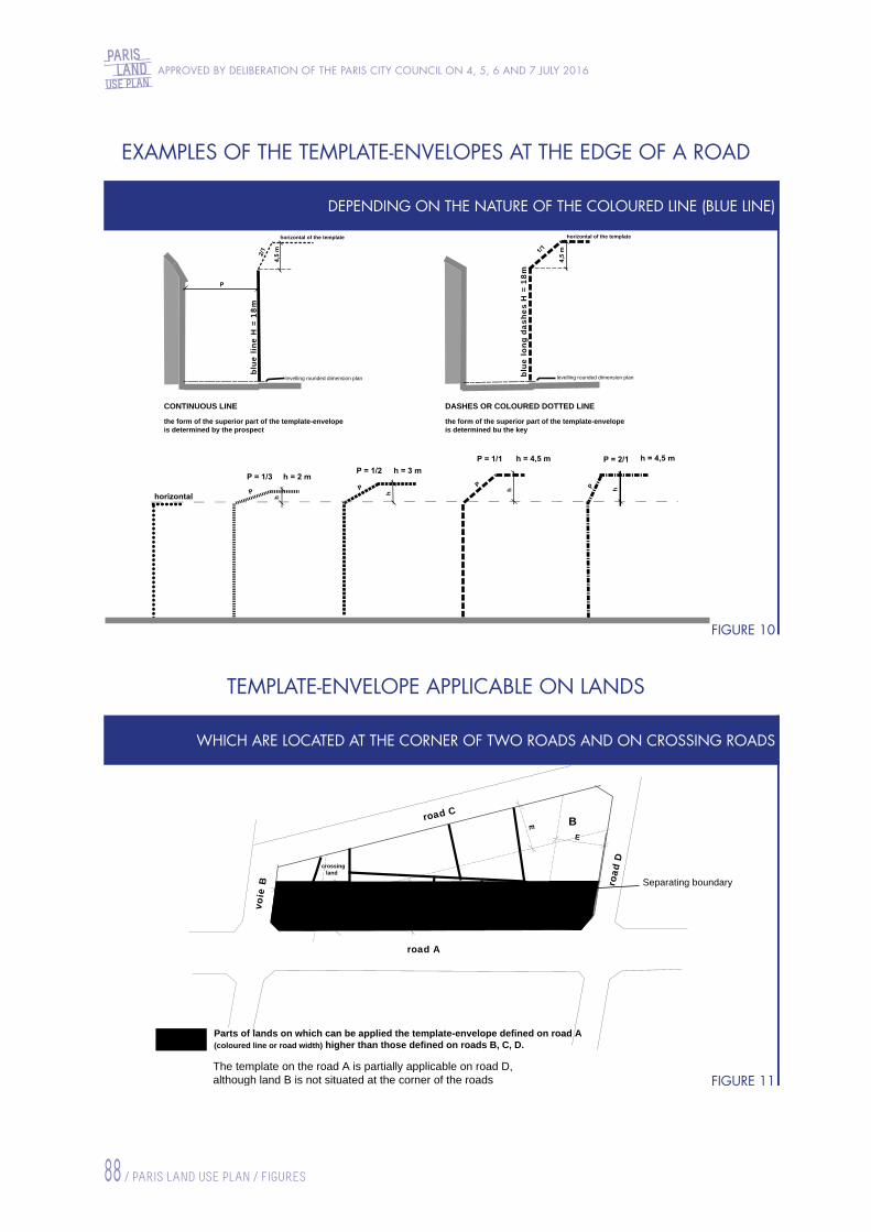
APPROVED BY DELIBERATION OF THE PARIS CITY COUNCIL ON 4, 5, 6 AND 7 JULY 2016
88 / PARIS LAND USE PLAN / FIGURES
PARISLAND
USE PLAN
levelling rounded dimension plan
horizontal of the template horizontal of the template
levelling rounded dimension plan
blue
line
H =
18m
blue
long
das
hes
H =
18m
CONTINUOUS LINE
the form of the superior part of the template-envelopeis determined by the prospect
DASHES OR COLOURED DOTTED LINE
the form of the superior part of the template-envelopeis determined bu the key
wid
th o
f E b
andE
E
E
E
Parts of lands on which can be applied the template-envelope defined on road A(coloured line or road width) higher than those defined on roads B, C, D.
crossingland
road A
voie
B road
D
road CB
A
Separating boundary
The template on the road A is partially applicable on road D,although land B is not situated at the corner of the roads
DEPENDING ON THE NATURE OF THE COLOURED LINE (BLUE LINE)
WHICH ARE LOCATED AT THE CORNER OF TWO ROADS AND ON CROSSING ROADS
FIGURE 10
FIGURE 11
EXAMPLES OF THE TEMPLATE-ENVELOPES AT THE EDGE OF A ROAD
TEMPLATE-ENVELOPE APPLICABLE ON LANDS
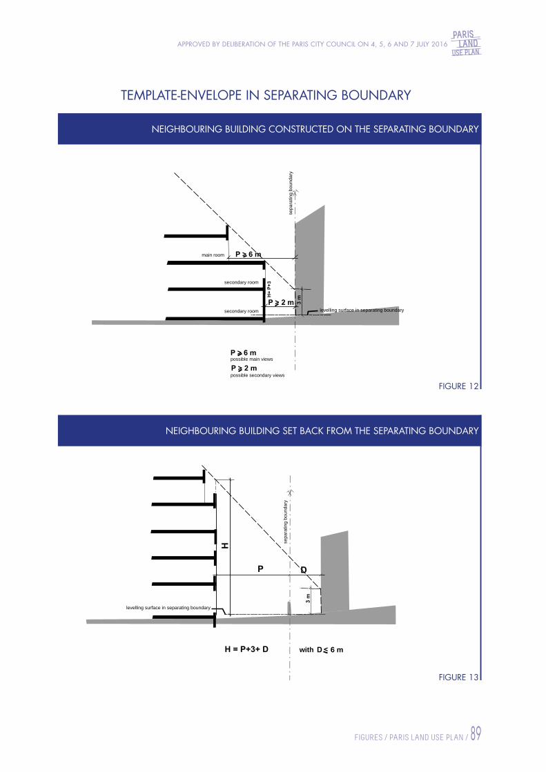
PARISLAND
USE PLANAPPROVED BY DELIBERATION OF THE PARIS CITY COUNCIL ON 4, 5, 6 AND 7 JULY 2016
FIGURES / PARIS LAND USE PLAN / 89
levelling surface in separating boundary
main room
secondary room
secondary room
sepa
ratin
g bo
unda
ry
possible main views
possible secondary views
levelling surface in separating boundary
sepa
ratin
g bo
unda
ry
with
NEIGHBOURING BUILDING CONSTRUCTED ON THE SEPARATING BOUNDARY
NEIGHBOURING BUILDING SET BACK FROM THE SEPARATING BOUNDARY
FIGURE 12
FIGURE 13
TEMPLATE-ENVELOPE IN SEPARATING BOUNDARY
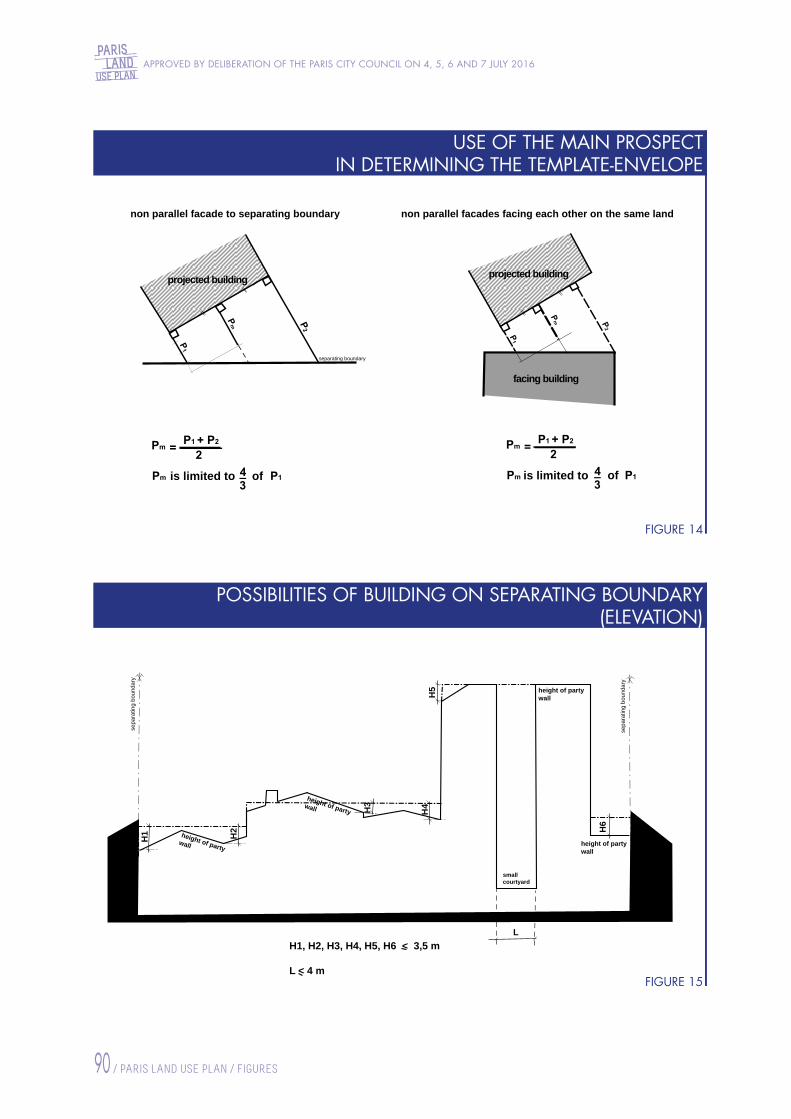
APPROVED BY DELIBERATION OF THE PARIS CITY COUNCIL ON 4, 5, 6 AND 7 JULY 2016
90 / PARIS LAND USE PLAN / FIGURES
PARISLAND
USE PLAN
non parallel facade to separating boundary
projected building projected building
facing building
non parallel facades facing each other on the same land
separating boundary
is limited to of ofis limited to
H5
L
H4H3
H2 H
6
H1
height of partywall
height of partywall
smallcourtyard
height of partywall
height of partywall
sepa
ratin
g bo
unda
ry
sepa
ratin
g bo
unda
ry
H1, H2, H3, H4, H5, H6 < 3,5 m
L < 4 m
USE OF THE MAIN PROSPECT IN DETERMINING THE TEMPLATE-ENVELOPE
POSSIBILITIES OF BUILDING ON SEPARATING BOUNDARY (ELEVATION)
FIGURE 14
FIGURE 15

PARISLAND
USE PLANAPPROVED BY DELIBERATION OF THE PARIS CITY COUNCIL ON 4, 5, 6 AND 7 JULY 2016
FIGURES / PARIS LAND USE PLAN / 91
smallcourtyard
heig
ht o
fpa
rty
wal
l
sepa
ratin
g bo
unda
ry
separating boundary
separating boundary
sepa
ratin
g bo
unda
ryse
para
ting
boun
dary
projected building
projected building
projected building
4 m
4 m
P > 6 m
H
H = P + 4
Fixation point of the template of the building A Fixation point of the template of the building A Main room
Main roomSecondary room
Building BBuilding A
Fixation point of the template of the building B
POSSIBILITIES OF BUILDING ON SEPARATING BOUNDARY (PLANS AND SECTIONS)
TEMPLATE-ENVELOPE OF CONSTRUCTIONS FACING EACH OTHER ON THE SAME LAND
FIGURE 16
FIGURE 17

APPROVED BY DELIBERATION OF THE PARIS CITY COUNCIL ON 4, 5, 6 AND 7 JULY 2016
92 / PARIS LAND USE PLAN / FIGURES
PARISLAND
USE PLAN
general principle is based on the most common blocks,generaly convex and in a mostly regular slope
following figures are dealing with particular cases
a) Incoming point b) Low or high or isolated point
Draft to be followed
Draft to be followed
Incomingpoint
Output straightlines
Superposed straight lines46 and 47
Highpoint
Underblock
UnderblockUnderblockUnderblockUnderblock
UnderblockUnderblock
UnderblockUnderblock
DETERMINATION OF THE BLOCK LEVELLING LEVELS GENERAL CASE
DETERMINATION OF BLOCK LEVELLING ROUNDED DIMENSION PLANS EXAMPLES OF PARTICULAR CASES
FIGURE 18.1
FIGURE 18.2
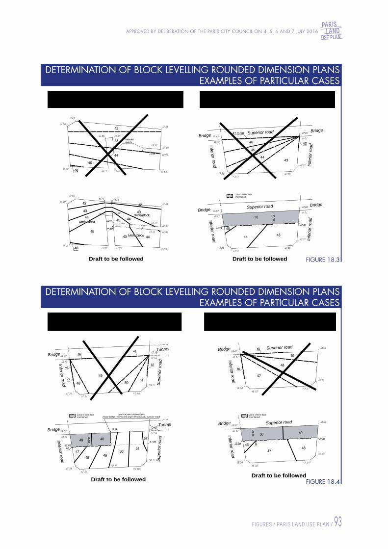
PARISLAND
USE PLANAPPROVED BY DELIBERATION OF THE PARIS CITY COUNCIL ON 4, 5, 6 AND 7 JULY 2016
FIGURES / PARIS LAND USE PLAN / 93
c) Presence of interior roads Road at the side of which there can be facadesSuperior (or interior) road
d)
Draft to be followed Draft to be followed
Interiorroads
BridgeBridge Superior road
Inferior road Infe
rior r
oad
47 to 50
UnderblockUnderblock
UnderblockUnderblock
UnderblockUnderblock
BridgeBridge Superior road
Inferior road Infe
rior r
oad
Zone of best floormaintained
Road at the side of which there can be facadesSuperior and inferior road
Road at the side of which there can be facadesSuperior and inferior corner
e) f)
TunnelBridge
Inferior road Sup
erio
r roa
d
Bridge Superior road
Inferior road
Bridge Superior road
Inferior road
TunnelBridge
Inferior road Sup
erio
r roa
d
Draft to be followedDraft to be followed
Zone of best floormaintained
Zone of best floormaintained
Junction point of two slopes(slope bridge / tunnel and slope inferior road / superior road)
DETERMINATION OF BLOCK LEVELLING ROUNDED DIMENSION PLANS EXAMPLES OF PARTICULAR CASES
DETERMINATION OF BLOCK LEVELLING ROUNDED DIMENSION PLANS EXAMPLES OF PARTICULAR CASES
FIGURE 18.3
FIGURE 18.4

APPROVED BY DELIBERATION OF THE PARIS CITY COUNCIL ON 4, 5, 6 AND 7 JULY 2016
94 / PARIS LAND USE PLAN / FIGURES
PARISLAND
USE PLAN
Road at the side of which there cannot be facades (peripherique, tunnel, bridge, etc.)
g)
Draft to be followed
43 to 50 Work
Work
s.e.l.r.
s.e.l.r. = S1+S2
s.e.l.r.
s.e.l.r.
S
S1S2
S
20% S
b10% 15 % S
a
a
1
svp*
2 b
svp*
svp*
c
c10 % S
possibility of repartition of open spaceswhich the regulations refer to (s.e.r.l.*)on the land depending on the environment
S part of land outside Z band
Z band = 15mroadroad
Z band = 15msurface area of open spaces
which the regulations refer to
part of land outside Z band
open ground open ground(by default svp*)
free planning
Whether surface c and part of the surface b are planned in roofings, terraces or landscaped walls
free planning open groundopen ground Terracesroofings
walls
Terracesroofings
walls
open spaces on the ground*s.e.l.r. : surface area of open spaces which the regulations refer to*svp : weighted landscaped surface
or
DETERMINATION OF BLOCK LEVELLING ROUNDED DIMENSION PLANS EXAMPLES OF PARTICULAR CASES
CALCULATION METHOD OF OPEN SPACES WHICH THE REGULATIONS REFER TO
FIGURE 18.5
FIGURE 19

PARISLAND
USE PLANAPPROVED BY DELIBERATION OF THE PARIS CITY COUNCIL ON 4, 5, 6 AND 7 JULY 2016
FIGURES / PARIS LAND USE PLAN / 95
TEMPLATE-ENVELOPE AT THE EDGE OF THE ROADMB1 perimeter : all roadsMB2 perimeter : roads equal or more than 20m wide
Ceiling height
Road ground
TEMPLATE-ENVELOPE AT THE EDGE OF THE ROADMB2 perimeter : roads less than 20m wide
Road ground
Ceiling height
10 m
m 73 = H
FACINGBUILDING
PROJECTEDBUILDING
PROJECTEDBUILDING
FACINGBUILDING
levelling rounded dimension planlevelling rounded dimension plan
TEMPLATE-ENVELOPE AT THE EDGE OF THE ROAD facing North and South esplanades
TEMPLATE-ENVELOPE AT THE EDGE OF THE ROAD avenue Ernest Renan and facing Hall 01 of the Exhibition Park
boulevard VictorH=20 m H=15 m
slope
2/1
slope 2/1
Hall 01avenue Ernest Renan
Maximal heightof buildings
Maximal heightof buildings
de fa
cto
limit
of th
eS
outh
esp
lana
de
de fa
cto
limit
of th
eN
orth
esp
lana
de
levelling roundeddimension plan
levelling roundeddimension plan
rue Oradour-sur-Glane
de fa
cto
limit
of th
e ro
ad to
be
crea
ted
alig
nmen
t
levelling roundeddimension plan
MASSENA-BRUNESEAU SUB-SECTOR
PORTE DE VERSAILLES SECTOR
FIGURE 20.1
FIGURE 20.2


KEY TO MAPS IN THE GENERAL ATLAS

APPROVED BY DELIBERATION OF THE PARIS CITY COUNCIL ON 4, 5, 6 AND 7 JULY 2016
98 / PARIS LAND USE PLAN / KEY TO MAPS IN THE GENERAL ATLAS
PARISLAND
USE PLAN
LS x-y Requirement that x % of the floor area is commited to housingand that y % of the floor area to be allocated to social housing,
LI x-y Requirement that x % of the floor area is commited to housingand that y % of the floor area is reserved for mid-market rent housing,
LI x Requirement that x m² of the floor area is commited to mid-market rent housing,under the conditions set out in article UG.2.2.4 § 2
LS x Requirement that x m² of the floor area is reserved for social housing,under the conditions set out in article UG.2.2.3 § 2
Road centre line (N zone)
Land reserved for the protection of crafttrades and manufacturing industries
General urban zone (UG)
I. Zoning
II. Location of facilities and planned developments
Reserved location for public green spacefor the benefit of the City of Paris (See the list in the regulations, volume 2)
V 12-01
Reserved location for public facilities, public works or installation of general interest (See the list in the regulations, volume 2)E 12-01
P 12-01Equipment location perimeter for public facilities, public works, publicgreen space or planned installation of general interest(See the list in the regulations, volume 2)
III. Planning and design of roads and traffic areas
Pedestrian layout
Reserved location for road widening or creation ofcommunal public road
Alignment easement (Public utility easement)
Public or private road (UG zone)
IV. Siting and heights of buildings
Vertical heightindicated by the colour : - H = 5 m : Pink- H = 7 m : Khaki- H = 10 m : Green- H = 12 m : Orange- H = 15 m : Purple- H = 18 m : Light blue- H = 20 m : Black- H = 23 m : Grey- H = 25 m : Navy blue
Crowning indicated by line type : - Complies with the provisions of articles UG 10.2.1 or UGSU 10.2.1 :- Horizontal : - P = 1/3, h = 2 m : - P = 1/2, h = 3 m : - P = 1/1, h = 4.5 m : - P = 2/1, h = 4.5 m :
Continuous lineDotted lineHatchesShort dashesLong dashesVariable dashes
- Same vertical height as the existing façade :
20m
Existing volume dimensions to retain
V. Protection of urban structures and architectural heritage
Protected building, or plot containing one or more protected buildings (See the list in the regulations, volume 2)
For information :
VI. Protection and landscaping of open spaces
VII. Sectors subject to special provisions
Protected green space (EVP)
Space to be released (EAL)
Open space to be landscaped (ELV)
Protected open space (ELP)
Classified wooded space (EBC)
Templates-envelopes :
Height :
Examples: height 18 m,crowning P = 1/1, h = 4.5 mheight 10 m,crowning P = 1/3, h = 2 m
Siting :
R+1Footprint of low-rise roadside buildings
with possible reference to "R+1" if one floor is authorised.
Plot highlighted for its heritage, cultural or landscape interest
Pedestrian link to be preserved, created or modified
Time-share transit platform for goods and wastetransported or disposed of by waterway
Reserved location for the purpose of housing contruction, social housing in accordance witharticle L.302-5 of the Construction and Housing Code, and the mid-market rent housingin accordance with article L.302-16 of the Construction and Housing Code
Urban zone of Majorurban services (UGSU) Sector of limited size and capacity
(See the list of sectors in the regulations, volume 2)
VIII. For information
- by a legal order grading it as an historic monument- by a legal order listing it as an historic monument
Plot containing an element protected under the historic monuments system :
Special protected element (See the list in the regulations, volume 2)
(L.151-41 3°)
(L.151-41 1°et 2°)
(L.151-41)
Perimeter to be the subject of a global development project(See the list in the regulations, volume 2)
(L.151-41 5°)
(L.151-41 4°)
3m with possible indication of widthRoad to be preserved, created or modified
4,00 m Maximum building footprint possibly limited in height and footprint25 %
Pedestrian crossing under a porch to be preserved
Brown
Siting without imposed recess
In sectors delimited by a purple dash ( ), a reduction to 1/2000th of the graphic documents of the Preservation and Enhancement Plans (PSMV) are reported for information purposes only and have no regulatory character. The Preservation and Enhancement Plans can be consulted at the Prefecture of Paris.
Zoning of areas saddled with reserved sites is visible on zoning map A
Maximum height of buildings relative to the levellingsurface of the island
Natural and forest zone (N)
Green urban zone (UV)
56,34mNO
Maximum height ofbuildings relative toOrthometric Levelling (NO)
Key to maps in the general atlas PLU approved 4, 5 and 6 July 2016

PARISLAND
USE PLANAPPROVED BY DELIBERATION OF THE PARIS CITY COUNCIL ON 4, 5, 6 AND 7 JULY 2016
KEY TO MAPS IN THE GENERAL ATLAS / PARIS LAND USE PLAN / 99
LS x-y Requirement that x % of the floor area is commited to housingand that y % of the floor area to be allocated to social housing,
LI x-y Requirement that x % of the floor area is commited to housingand that y % of the floor area is reserved for mid-market rent housing,
LI x Requirement that x m² of the floor area is commited to mid-market rent housing,under the conditions set out in article UG.2.2.4 § 2
LS x Requirement that x m² of the floor area is reserved for social housing,under the conditions set out in article UG.2.2.3 § 2
Road centre line (N zone)
Land reserved for the protection of crafttrades and manufacturing industries
General urban zone (UG)
I. Zoning
II. Location of facilities and planned developments
Reserved location for public green spacefor the benefit of the City of Paris (See the list in the regulations, volume 2)
V 12-01
Reserved location for public facilities, public works or installation of general interest (See the list in the regulations, volume 2)E 12-01
P 12-01Equipment location perimeter for public facilities, public works, publicgreen space or planned installation of general interest(See the list in the regulations, volume 2)
III. Planning and design of roads and traffic areas
Pedestrian layout
Reserved location for road widening or creation ofcommunal public road
Alignment easement (Public utility easement)
Public or private road (UG zone)
IV. Siting and heights of buildings
Vertical heightindicated by the colour : - H = 5 m : Pink- H = 7 m : Khaki- H = 10 m : Green- H = 12 m : Orange- H = 15 m : Purple- H = 18 m : Light blue- H = 20 m : Black- H = 23 m : Grey- H = 25 m : Navy blue
Crowning indicated by line type : - Complies with the provisions of articles UG 10.2.1 or UGSU 10.2.1 :- Horizontal : - P = 1/3, h = 2 m : - P = 1/2, h = 3 m : - P = 1/1, h = 4.5 m : - P = 2/1, h = 4.5 m :
Continuous lineDotted lineHatchesShort dashesLong dashesVariable dashes
- Same vertical height as the existing façade :
20m
Existing volume dimensions to retain
V. Protection of urban structures and architectural heritage
Protected building, or plot containing one or more protected buildings (See the list in the regulations, volume 2)
For information :
VI. Protection and landscaping of open spaces
VII. Sectors subject to special provisions
Protected green space (EVP)
Space to be released (EAL)
Open space to be landscaped (ELV)
Protected open space (ELP)
Classified wooded space (EBC)
Templates-envelopes :
Height :
Examples: height 18 m,crowning P = 1/1, h = 4.5 mheight 10 m,crowning P = 1/3, h = 2 m
Siting :
R+1Footprint of low-rise roadside buildings
with possible reference to "R+1" if one floor is authorised.
Plot highlighted for its heritage, cultural or landscape interest
Pedestrian link to be preserved, created or modified
Time-share transit platform for goods and wastetransported or disposed of by waterway
Reserved location for the purpose of housing contruction, social housing in accordance witharticle L.302-5 of the Construction and Housing Code, and the mid-market rent housingin accordance with article L.302-16 of the Construction and Housing Code
Urban zone of Majorurban services (UGSU) Sector of limited size and capacity
(See the list of sectors in the regulations, volume 2)
VIII. For information
- by a legal order grading it as an historic monument- by a legal order listing it as an historic monument
Plot containing an element protected under the historic monuments system :
Special protected element (See the list in the regulations, volume 2)
(L.151-41 3°)
(L.151-41 1°et 2°)
(L.151-41)
Perimeter to be the subject of a global development project(See the list in the regulations, volume 2)
(L.151-41 5°)
(L.151-41 4°)
3m with possible indication of widthRoad to be preserved, created or modified
4,00 m Maximum building footprint possibly limited in height and footprint25 %
Pedestrian crossing under a porch to be preserved
Brown
Siting without imposed recess
In sectors delimited by a purple dash ( ), a reduction to 1/2000th of the graphic documents of the Preservation and Enhancement Plans (PSMV) are reported for information purposes only and have no regulatory character. The Preservation and Enhancement Plans can be consulted at the Prefecture of Paris.
Zoning of areas saddled with reserved sites is visible on zoning map A
Maximum height of buildings relative to the levellingsurface of the island
Natural and forest zone (N)
Green urban zone (UV)
56,34mNO
Maximum height ofbuildings relative toOrthometric Levelling (NO)
Key to maps in the general atlas PLU approved 4, 5 and 6 July 2016
KEY TO MAPS IN THE GENERAL ATLAS


Production: Mairie de Paris, direction de l'Urbanisme, Service de l’innovation, de la stratégie et de l’urbanisme règlementaire; Service communication et concertation -
Credits: Mairie de Paris: DICOM, Jean-Baptiste Gurliat; DU, Christophe Jacquet, Jacques Leroy

This document constitutes the translation, in
English language, of parts of the Paris Land Use
Plan Regulations, which concern the General urban
zone.
These translations have no legal force, and are
provided for informational purposes only.
Only the French version of these texts, available
at http://pluenligne.paris.fr/ and, upon request, at
the Paris Directorate in charge of town planning
(Direction de l’Urbanisme, 6 promenade Claude-
Lévi-Strauss, CS 51388, 75639 PARIS CEDEX 13)
have legal force.
Rules related to other zones have to be consulted in
their French version.
PARISLAND
USE PLAN
E E E
E E E
E E E
E E E
E E E E E E E E E E
E E E E E E E E E E
E E E E E E E E E E
E E E E E E E E E E
E E E E E E E E E E E
E E E E E E E E E E E
E E E E E E E E E E E
E E E E E E E E E E E
E E E
E E E
E E E
E E E
E E E
E E
E E
E E
E E
E E
E E E E E E E E E E
E E E E E E E E E E
E E E E E E E E E E
E E E E E E E E E E
E E E E E E E E E E
E E E E E E E E E E
E E E E E E E E E E
E E E E E E E E E E
E E E E E E E E E E
E E E E E E E E E E E
E E E E E E E E E E E
E E E E E E E E E E E
E E E E E E E E E E E
E E E E E E E E E E E
E E E E E E E E E E E
E E E E E E E E E E E
E E E E E E E E E E E
E E E E E E E E E E E
E E
E E E
E E E
E E E E E E E
E E E E E E E
E E E E E E E
E E E E E E E
E E E E E E E
E E E E E E E E
E E E E E E E E
E E E E E E E E
E E E E E E E E
E E E E E E E E
E E E E E E E E
E E
E E E E
E E E E
E E E E
E E E E
E E E E
E E E E
E E E E E
E E E E E
E E E E E
E E E E E
E E E E E
E E E E E
E E
E E
E E
E E E
E E E
E E E E
E E E E
E E E E
E E E E E E
E E E E E E
E E E E E E
E E E E E E
E E E E E E
E E E E E E
E E E E E E E
E E E E E E E
E E E E E E E
E E E E E E E
E E E E E E E
E E E E E E E
E E E E E E E
E E E
E E E
E E E
E E E
E E E
E E E
E E E
E E
E E
E E E
E E E
E E E
E E
E E
E E
E E
E E
E E E
E E E
E E
E E
E E E
E E E
E E E
E E E
E E E
E E E
Q. d'IvryRue de Charenton
Bd de Reuilly
Boulevard Poniatowski
Rue de Reuilly
Rue de Wattignies
Félix Éboué
Place
Rue de Picpus
Avenue de Saint-Mandé
Av. du
Gal M
ichel
Bizot
Boule
vard
de Pi
cpus
Avenue Daumesnil
Route de Reuilly
Aven
ue d
u Dr
Arn
old N
ette
r
Boule
vard
Soult
Rout
e Do
m P
érig
non
Route de Ceinture du Lac DaumesnilRoute de la Plaine
Route de Ceinture du Lac Daumesnil
Route du Bac
Boulevard de Ménilmontant
Rue Léon Frot
Rue du Fg Saint-Antoine
Rue de Charonne
Rue des BouletsRue Sorbier
Avenue Philippe-Auguste
PERE LACHAISE
Rue de Montreuil
CIMETIERE
DU
Nation
Placede la
Boulevard de Charonne
R. A. Dumas
Rue de
Bagno
let
Rue Vit
ruve
Rue des Pyrénées
Rue de la Réunion
Rue Belgrand
Cours de Vincennes
Rue d'Avron
Rue de Lagny
Rue des Orteaux
Rue Saint-Blaise
Boulevard Davout
DES
Canal Saint Denis
Rue Petit
BUTTE
S
Canal
de
l'O
urcq
Avenu
e Core
ntin C
ariou
Avenue Jean Jaurès
R. de Crimée
CHAUMONT
Rue Botzaris
R. Manin
Rue d'Hautpoul
Bd Macdonald
R. David d'Angers
R. du
Gal B
runet
Rue de Mouzaïa
Boulevard SérurierBd d'Indochine
Bd d'AlgérieRue Pelleport
République
Rue Saint-Maur
Avenue Parmentier
Place de la Rue de MénilmontantRue du Fa
ubourg du Temple
Boule
vard
Mor
tier
Boulevard de Belleville
Quai de Jemmapes R. des Couronnes
Rue d
e Lan
cry
Rue St-FargeauRue de Belleville
Rue HaxoRue de
la Gra
nge au
x Belle
s
Aven
ue G
ambe
tta
Av. C
laude
Vell
efau
x
CANA
L
SAINT
M
ARTIN
Rue de Belleville
Av. Simon BolivarQuai
de Va
lmy
R. Compans
Boulevard SérurierPARC R. d
u Pré S
t-Gervai
s
Av. Mathurin Moreau
Rue
M. D
orm
oy
Rue Louis Blanc
Rue Philippe de Girard
Rue
Pajol
Rue du
Fg Sa
int-M
artin
Boulevard Ney
Rue de
l'Aqued
uc
Rue Riquet
Rue de l'Évangile
Rue d
e Tan
ger
Rue d
'Aub
ervilli
ersBd
de
la Vi
llette
Rue C
urial
Bassin
d
e
la
Villette
Avenu
e de F
landre
Avenue Secrétan
Rue de
Meaux
Boulevard Macdonald
Rue Armand Carrel
Rue de l' Ourcq
Boulevard Vincent Auriol
Avenue d'Ivry
D'AUSTERLITZ
Boulevard M
asséna
Rue Jeanne d'Arc
GARE
Rue NationaleRue de Bercy
Rue du Château des Rentiers
Q. d'Austerlitz
Rue du Chevaleret
Q. de la Rapée
Rue Regnault
Rue de Patay
DE LYON
GARE
Q. de la Gare
Rue Neuv
e Tolbia
c
Q. François Mauriac
Avenue de France
Avenue Daumesnil
LA
PARC DE BERCY
Q. Panhard et Levassor
Boulevard de Bercy
Q. de BercySEINE
Q. des Célestins
Rue Vie
ille du
Temple
Rue des Francs Bourgeois
Rue de Bretagne
Rue Saint-Antoine
Q. Henri IV
Boulevard Henri IV
Bd Morland
Rue
de Tu
renn
e
Boulevard du Temple
Boule
vard
Bourd
onBo
uleva
rd de
la B
astill
e
Bastille
Boulevard Beaumarchais
Rue Jean-Pierre Timbaud
de la
Place
Boule
vard
Richa
rd Le
noir
Rue de Lyon
Rue du Chemin Vert
Avenue de la République
Boulevard Voltaire
Aven
ue Le
dru-R
ollin
Rue Oberkampf
Rue Crozatier
Rue de la Roquette
Boulevard Diderot
R. de
l'Am
iral
Rue de la SantéRue Gay-Lussac
Boulevard de Port-Royal
Boulevard Auguste Blanqui
Rue V
ergnia
udRu
e d'U
lmRu
e de
la G
lacièr
eRue Claude Bernard
Boulevard Kellerm
ann
Rue LhomondRue Barrault
Rue Mouffetard
Rue B
obillo
t
Avenue des Gobelins
Rue de Tolbiac
Rue Censier
d'ItaliePlace
Boulevard Saint-Marcel
Avenue d'Italie
D'HISTOIRE NATURELLEMUSEUM NATIONAL
Boule
vard
de l'H
ôpita
l
Rue Buffon
Avenue de Choisy
Q. Saint-Bernard
Bd Montmartre
Rue de Rivoli
Rue d
u Lou
vre
Jardin des Halles
Rue Étienne Marcel
Q. de la Mégisserie
Rue Montmartre
Bd Poissonnière
Rue Réaumur
Rue
du F
g Po
isson
nière
Rue S
aint-D
enis
Rue d'Aboukir
Q. de Gesvres
Bd de Bonne Nouvelle
Rue S
aint-M
artin
Boule
vard
de S
ébas
topol
Rue d
u Ren
ard
Rue Rambuteau
Hôtel
Rue B
eaub
ourg
Rue de Rivoli
Boule
vard
de S
trasb
ourg
Rue de Turbigo
Rue d
u Tem
ple
Bd Saint-Martin
Rue d
es Arc
hives
Rue du Château d'Eau
Rue d
'Hau
teville
Boulevard de Magenta
Rue de Provence
ST LAZAREDE L'EST
Rue de ChâteaudunGARE
Rue du Faubourg Montmartre GARERue St-Lazare Rue
de Maub
euge
Rue la Fayette
Rue Blanche
Rue d
es M
artyr
s
Rue
d'Am
sterd
am
Rue de Clichy Rue Je
an-Ba
ptiste
Pigal
le
Rue d
u Fg
Saint
-Den
is
DU NORDRue
de R
oche
chou
art
GAREDunkerque
Rue de
Boulevard de Rochechouart
Boulevard de Clichy
Boulevard de la ChapelleRue L
epic
la Ma
delei
ne
JARDIN DES TUILERIES
Rue T
ronch
et
Rue de Lille
Q. des Tuileries
la MadeleineBd de
R. de
Casti
glion
e
Vendôme
Place
Rue de Rivoli
Rue Saint-Honoré
Q. Voltaire
Rue d
e la P
aix
Bd des Capucines
OPERA
Rue du Quatre Septembre
Q. Malaquais
Avenue de l'Opéra
Q. du Louvre
Bd des Italiens
DU LOUVRE
PALA
IS R
OYAL
Rue
de
Ric
helie
u
PALAIS
Q. de Conti
Rue
V
ivien
ne
Avenue de Clichy
Rue
de C
ligna
ncou
rt
Boule
vard
Bar
bès
MONTMARTRE R. de
sDE
Poiss
onnie
rs
Rue DoudeauvilleCIMETIERE
Rue Custine
Rue Caulaincourt
Rue Ramey
Rue Lamarck
Aven
ue de
Sain
t-Oue
n
Rue MarcadetRue Ordener
Rue D
amrém
ont
Boulevard OrnanoR. du
Mt C
enis
Jonquière
Rue du Poteau
Rue Championnet
Rue Vauvenargues
Rue de la Chapelle
Rue BelliardBoulevard Bessières Boulevard Ney
Rue SoufflotJARDIN Ru
e du C
al Lem
oine
Rue MongeBoule
vard
Saint
-Mich
el
Rue S
aint-J
acqu
es
LUXEMBOURGPALAIS DURu
e Bo
napa
rte
Rue des EcolesRue d
e Ren
nes
Rue de Tournon
Q. de la Tournelle
ILE SAINT LOUIS
Q. de Montebello
Boulevard Saint-GermainRue du Four
Q. St-Michel
ILE DE LA CITE
Q. de l'Hôtel de Ville
AugustinsRue D
auph
ine
Rue d
u Bac
Bd du
Palai
s
Rue de Seine
Q. des Gds
de V
ille
Boulevard du Montparnasse
Avenue du Maine
DU MONTPARNASSERue Froidevaux
Boulevard Edgar QuinetCIMETIERE
Aven
ue du
Géné
ral Le
clerc
Boulevard Raspail
Rue d
e la
Tomb
e Iss
oire
Rochereau
Rue d'Assas
Denfert-
Rue Notre-Dame
Place
Avenue Reille
Ave.
Denfe
rt-Roch
ereau
des Champs
Avenue René Coty
Boulevard Jourdan
Boulevard Saint-Jacques
DU LUXEMBOURG
CITE UNIVERSITAIRE
PARC DE MONTSOURIS
Ave.
de
l'Obs
erva
toire
Boulevard Arago
Rue d'Alésia
Mouc
hez
Voie Georges Pompidou
Boule
vard
de
la To
ur-M
aubo
urg
Aven
ue
Fra
nklin
D. R
oose
velt
Avenue de Saxe
Ave. de Tourville
DES INVALIDES
Aven
ue d
e Br
eteu
il
Rue St-Dominique
HOTEL
INVALIDES
ESPLANADE
Avenue des Champs Élysées
DES
Boule
vard
des
Inva
lides
Rue de Sèvres
Rue de Grenelle
Rue de Babylone
Rue de Varenne
Rue Vaneau
Concorde
Rue d
e Bell
echass
e
de la
Boulevard Saint-Germain
Place
Rue du
Cherch
e-Midi
Rue
Roy
ale
Q. Anatole France
Rue de Tocqueville
Boulevard Malesherbes
Bouleva
rd Berth
ier
Boulevard Haussmann
Rue du Fg
R. Jouffroy d'A
bbans
Rue de
Monceau
Av. Matig
non
Avenue de Messine
Saint-Honoré
Rue la Boétie
Av. de
Mari
gny
Boulevard Malesherbes
Rue C
ardine
t
Rue de Mirom
esnil
Rue Le
gendre
Boulevard des Batignolles
Rue P
ouch
et
Rue du Rocher
R. de la
Rue Guy Môquet
Rue de Rome
Place
de
Rue Lecourbe
Rue d
e Dan
tzig
Rue de
la Cro
ix Nive
rt
Rue de l'Abbé Groult
Rue des Morillons
Rue d'Alleray
Rue Blomet
Rue Cambronne
Rue B
rancio
n
Rue de la Procession
Rue de Vouillé
Rue du
Dr Ro
ux
Rue F
alguiè
reRue
Vercin
gétori
xRue
Didot
Boulevard Brune
Rue Ra
ymond
Lossera
nd
Bd Pasteur
Bd de Vaugirard
DE MONTROUGE
CIMETIERE
MONTPARNASSE
Rue d
es Pla
ntes
GARE
Avenue J
ean Mouli
n
Rue du Château
Rue de Vaugirard
et du O
nze No
v.
Trocad
éro
Jardin
s du T
rocadé
ro
Boulevard de Grenelle
Rue d
e Lou
rmel
Aven
ue Kl
éber
Rue du Théâtre
Q. Bra
nly
Av. Pier
re Ier d
e Serbi
e
PARC DU CHAMP DE MARS
Av. du Président Wilson
Avenue de Suffren
Av. de New York
Avenue de la Bourdonnais
Boulevard Garibaldi
Aven
ue R
app
Avenue George V
Rue François Ier
ECOLE
MILITAIR
E
Avenue Bosquet
Avenue
de la
Motte-P
icquet
Avenue
de
Low
endal
Avenue
Montaign
e
Rue de l'Université
Q. d'Orsay
Aven
ue
de
Ségu
r
Avenue Duquesne
Avenue de la Grande Armée
Boulev
ard Go
uvion-
Saint-C
yr
Avenue V
ictor Hugo
Avenue des Ternes
Bouleva
rd Pere
ire
Av. Carnot
de Gaulle
CharlesAv
enue
Niel
Av. Mac-M
ahon
Place
Avenue d'Iéna
Rue Pie
rre Demours
Boulev
ard de
Reims
Avenue Marceau
Av. de
Wag
ram
Avenue H
oche
Av. de Friedland
Avenue des Champs Élysées
Rue de Courcelles
Boulevard de Courcelles
Avenue de Villiers
Rue de Prony
Rue de l'Assomption
Av. Th
éoph
ile Ga
utier
Av. Henri
Martin
Rue du Ranelagh
Route de la Porte Dauphine à la Porte des Sablons
Boule
vard
Lanne
s
Route de la Porte des Sablons à la Porte Maillot
Rue d
e la
Pomp
e
R. de Boulainvilliers
Rue Ra
ynouar
d
Rue S
ponti
niFLE
UVE
Rue de la Tour
Avenue Georges Mandel
Rue de Longchamp
Bd de l'A
miral Bruix
Avenue Foch
Rue de Passy
Avenue Bugeaud
Avenue Paul D
oumer
Q. de
Grenel
le
Avenue d'Eylau
Av. de Malakoff
Bd Delessert
Avenue Émile Zola
Place
du
Avenue Raymond Poincaré
Rue M
ichel-
Ange
Boulevard Exelmans
Boulev
ard M
urat
Rue Molitor
Q. Sa
int-Ex
upéry
R. Ch
ardon
- Laga
cheQ.
d'Issy
-Les-M
oulin
eauxLA
PARC DE SPORTS ET DE LOISIRS
Rue Mirabeau
Aven
ue de
Versa
illes
Bd du Gal Martial Valin
HELIPORT DE PARIS-ISSY
SEINE
Q. An
dré Ci
troën
Rue Balard
Rue de la Convention
Boulevard Victor
Rue S
aint-C
harle
s
PARC DES EXPOSITIONS
Avenue F
élix Fau
re
Rue Desnouettes
Rue de Javel
Boulevard Lefebvre
Rue d
u Com
merce
Rue de
Vaugira
rd
Avenue de la Porte d'Auteuil
Route d
e Boulo
gne à P
assy
Route du Champ d'Entrainement
Allée S
aint-D
enis
Avenue de l'Hippodrome
Route de Suresnes
Chem
in de
Ceint
ure du
Lac I
nférie
ur
Allée
des F
ortific
ation
s
Route de la Muette à Neuilly
Route des Lacs à Passy
Allée de Longchamp
Bd de
Mon
tmore
ncy
Av. du Mahatma Gandhi
Rue J. d
e la Fon
taine
Boule
vard
Such
etAv.
Raph
aël
Aven
ue M
ozar
t
Av. Ingre
s
Av. Prudhon
Plan de Sauvegardeet de Mise en Valeur
du 7ème arrondissement
Plan de Sauvegardeet de Mise en Valeur
du Marais
P A N T I N
C L I C H Y
I V R Y - S U R - S E I N E
C O U R B E V O I E
V A N V E S
M A L A K O F F
N E U I L L Y - S U R - S E I N E
I S S Y - L E S - M O U L I N E A U X
M O N T R O U G E
L E V A L L O I S - P E R R E T
C H A R E N T O N - L E - P O N T
L E P R É -S A I N T - G E R V A I S
erème
èmeème
ème
ème
ème
ème ème
ème
ème
ème
èmeème
ème
ème
ème
ème
ème
ème
98
7
6
5
4
3
2
1 20
1918
17
16
15
14 13
12
11
10
D7
N13
D989
D71
D9B
D2
D17
D908
D103
D50
N3
D909
D38
D19A
D9
D69
D19B
D62
D15
8
D35BIS
D912
D72
D115
D911
D6
D1
D224
D12
D154BD154A
D920
D130
D76
D152A
D20
D19
D37
D117
D83
D156A
D35T
ER
D6A
D150A
D127B
D106
N2
D20B
N1
D150D63
A
D910
D20A
D12
7A
D210D154
D6B
D11
1
D906
D110
D72A
D907
D120
D5
N301
N302
D143A
D213B
D150
D7
D7
D106
N13
D7
D83
D150
D76
N13
D69
D1
D154
D50
D1
D92
0
D908
D19 N1
D152A
D50
D1
D154A
N13
D20
D38
D20
D6
D6A
D150
A - ZONE PLAN
®
Paris Land Use Planapproved on
4th, 5th and 6th of July 2016
Scale : 1/25 000ème
0 500 1 000 1 500 M
General Urban Zone
Zone of MajorUrban Services
Green Urban Zone
Natural and ForestZone


