GeoAnalytics – A key component for insurance industry disruption Geo Risk Insurance Seminar – London, 13th of March 2018 Andreas Siebert, Head Geospatial Solutions Image: used under license from Shutterstock.com Source: Earthstar Geographics, Esri, Munich Re Source: Earthstar Geographics, Esri, Munich Re
Transcript
GeoAnalytics –
A key component for insurance industry disruption
Geo Risk Insurance Seminar – London, 13th of March 2018
Andreas Siebert, Head Geospatial Solutions
Image: used under license from Shutterstock.com
Source: Earthstar Geographics, Esri, Munich Re
Source: Earthstar Geographics, Esri, Munich Re
Image: used under license from shutterstock.com
1 GeoAnalyticsChallenges & Chances
Data
mesh-up
LI & BI
Integration
&
Access
Analytics
&
Methods
Drivers for
GeoAnalytics
GeoAnalytics in the insurance industryDriving forces
…improved data granularity
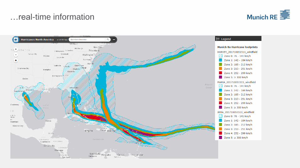
…real-time information
Source: Descartes Lab, 2017
…new methods
(machine learning, artificial intelligence)
…new platforms and collaborations
Centralized
data hosting
Analytical
tools
In-memory-
technologies
accelerating
processing
Cost-efficient
implementation
HDFS File System
Hadoop & Data Lake Tools
Existing HANAsStructured transactional
business data
SAS LASRData for ad-hoc
in-memory analytics
HANA
Long term unstructured and structured data
Project Folders
User Folders
SAS Visual Analytics
SAS Enterprise Guide
SAS Enterprise Miner
SAS Contextual Analytics
SAS Data Loader
Access to Hadoop /
Embedded ProcessSAS Autoload Folders
Access to
HANA
Access to Oracle /
SQL Server
SAS Mobile BI
Terminalserver
Browser
MS Office Add-in
Cloud
Computing
…new IT-architectures (Data Lake)
…state-of-the-art access to information (dashboards)
Geospatial IT-Landscape
Big picture & technical architecture2
Geospatial@MunichRe
System architecture - Providing Geoinformation via APIs
APIs
ArcGIS Server
CLIENT
APPLICATIONS
GeoDataService
(GDS)GDS WebService
Geocoder
GEODATA
GeocodingGeospatial AnalyticsMaps
Geospatial
Analytics
Geospatial@MunichRe
Providing multiple data categories
Environment
data
Infrastructure
NatCatHazard
Industrial Locations
Geozones
Footprints
Exposuredata
Life & Health
Claims & loss data
Social Media
Model information, Budget data
& Rates
Socio-economic
data
Telematics
Political risks
Geocoding
Geospatial
Analytics
Geospatial@MunichReMultiple solutions along the business value chain
ProductDevelopment
Marketing & Sales
AccumulationControl
Claims Management
Pricing
RiskAssessment
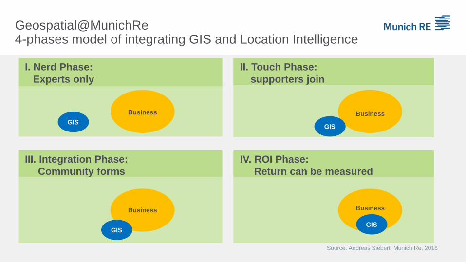
I. Nerd Phase:
Experts only
II. Touch Phase:
supporters join
IV. ROI Phase:
Return can be measured
III. Integration Phase:
Community forms
Business
GIS
Business
Business
Business
Source: Andreas Siebert, Munich Re, 2016
GIS
GISGIS
Geospatial@MunichRe4-phases model of integrating GIS and Location Intelligence
Internal Solutions
„visible“
SAFIR
Internal Solutions
„invisible“
GeoDataServices
External
Client
Services
NATHAN
Geospatial@MunichRe„Visibility“ of location based services for risk managers
GDS GeoData
Service
FAB
NatCat
SERVICE
MR-ET
CPM M.IN.D
AREA
NATHANSAFIR
Geospatial@MunichReSolutions and tools are powered by the GeoDataService (GDS)
SAFIRGroup-wide platform for GeoAnalytics & business apps3
Spatial Analytics for Insurance Risks (SAFIR)Collaboration platform for business solutions and innovation