29
GEODIM & Romanian Emergency Services Iulia DANA NEGULA 1 , Vasile CRACIUNESCU 2 , Ion NEDELCU 1 1 – Romanian Space Agency, 2 – National Meteorological Administration
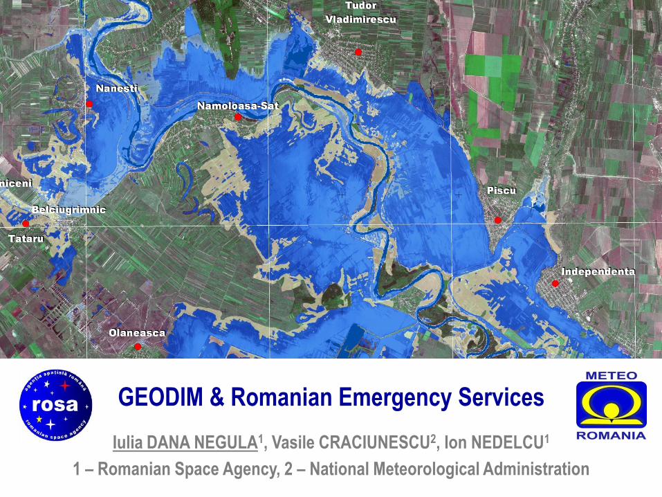
GEODIM & Romanian Emergency Services
Iulia DANA NEGULA1, Vasile CRACIUNESCU2, Ion NEDELCU1
1 – Romanian Space Agency, 2 – National Meteorological Administration
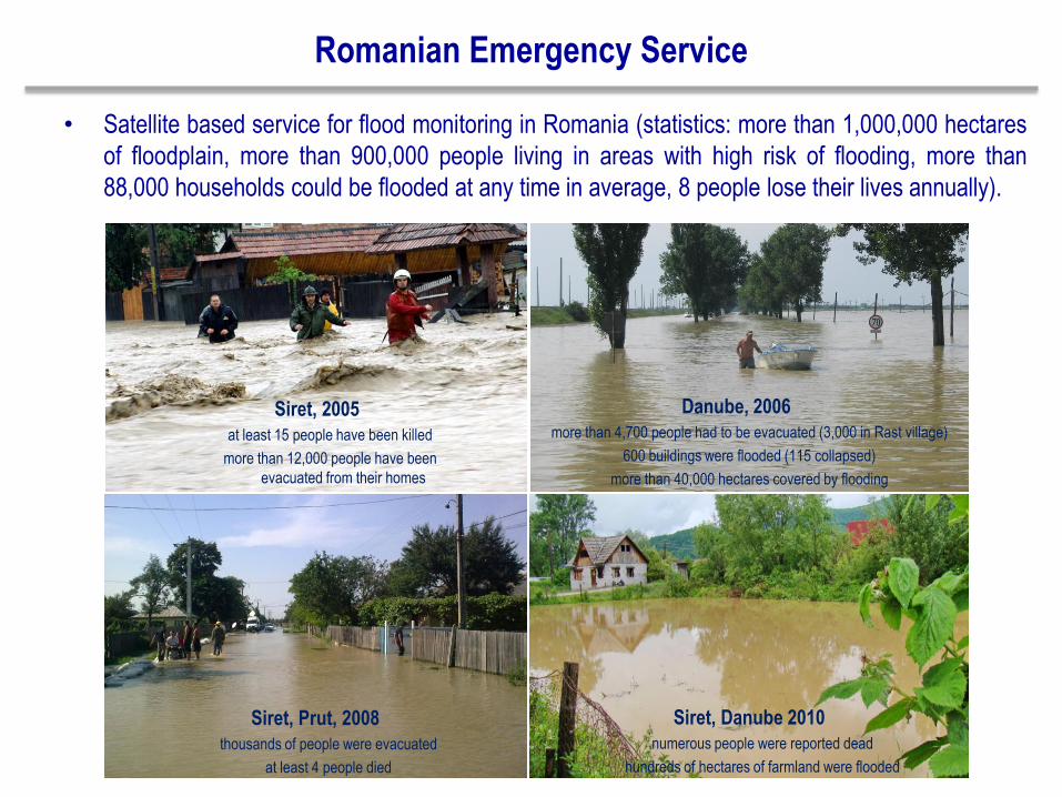
Romanian Emergency Service
• Satellite based service for flood monitoring in Romania (statistics: more than 1,000,000 hectares
of floodplain, more than 900,000 people living in areas with high risk of flooding, more than
88,000 households could be flooded at any time in average, 8 people lose their lives annually).
Siret, 2005
at least 15 people have been killed
more than 12,000 people have been
evacuated from their homes
Danube, 2006
more than 4,700 people had to be evacuated (3,000 in Rast village)
600 buildings were flooded (115 collapsed)
more than 40,000 hectares covered by flooding
Siret, Prut, 2008
thousands of people were evacuated
at least 4 people died
Siret, Danube 2010
numerous people were reported dead
hundreds of hectares of farmland were flooded
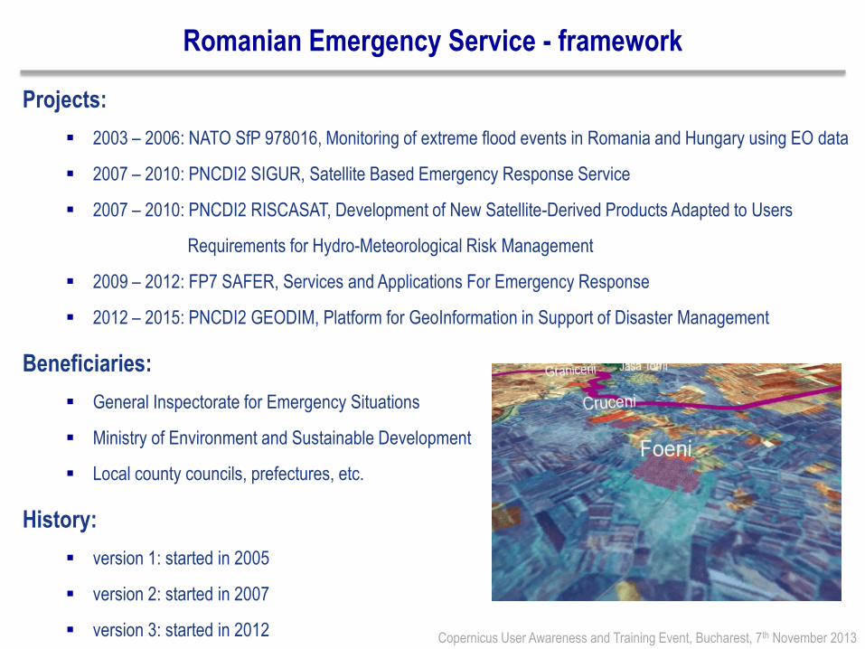
Romanian Emergency Service - framework
Projects:
2003 – 2006: NATO SfP 978016, Monitoring of extreme flood events in Romania and Hungary using EO data
2007 – 2010: PNCDI2 SIGUR, Satellite Based Emergency Response Service
2007 – 2010: PNCDI2 RISCASAT, Development of New Satellite-Derived Products Adapted to Users
Requirements for Hydro-Meteorological Risk Management
2009 – 2012: FP7 SAFER, Services and Applications For Emergency Response
2012 – 2015: PNCDI2 GEODIM, Platform for GeoInformation in Support of Disaster Management
Beneficiaries:
General Inspectorate for Emergency Situations
Ministry of Environment and Sustainable Development
Local county councils, prefectures, etc.
History:
version 1: started in 2005
version 2: started in 2007
version 3: started in 2012
Copernicus User Awareness and Training Event, Bucharest, 7th November 2013

Romanian Emergency Service – processing chain
Copernicus User Awareness and Training Event, Bucharest, 7th November 2013
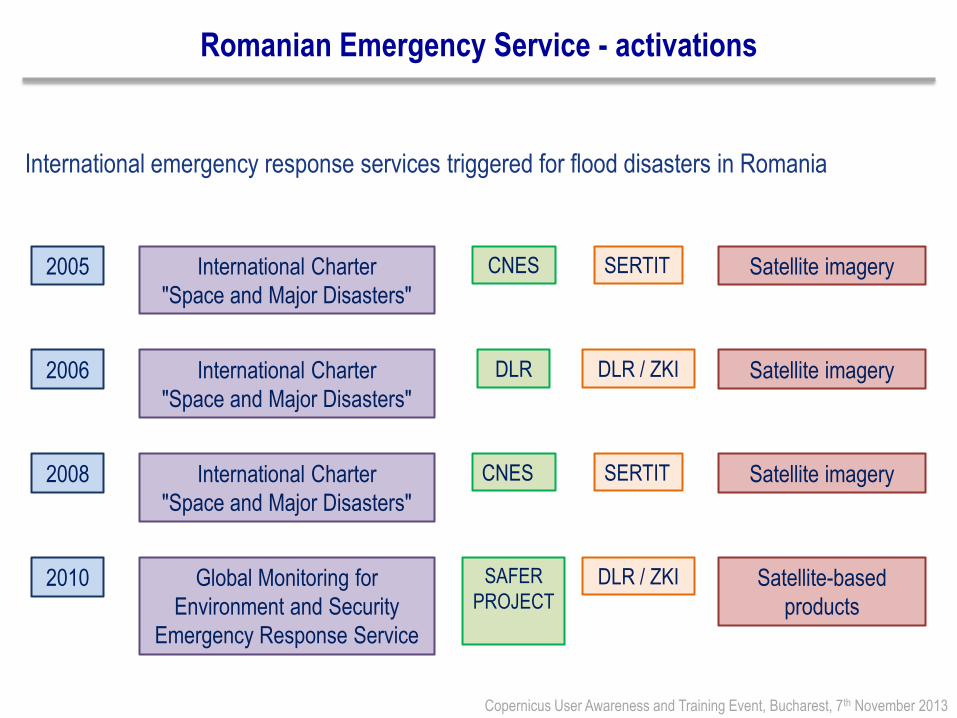
Romanian Emergency Service - activations
International emergency response services triggered for flood disasters in Romania
Copernicus User Awareness and Training Event, Bucharest, 7th November 2013
2005 International Charter
"Space and Major Disasters"
CNES SERTIT Satellite imagery
2006 International Charter
"Space and Major Disasters"
DLR DLR / ZKI Satellite imagery
2008 International Charter
"Space and Major Disasters"
CNES SERTIT Satellite imagery
2010 Global Monitoring for
Environment and Security
Emergency Response Service
SAFER
PROJECT DLR / ZKI Satellite-based
products

Romanian Emergency Service – examples of maps - 2005
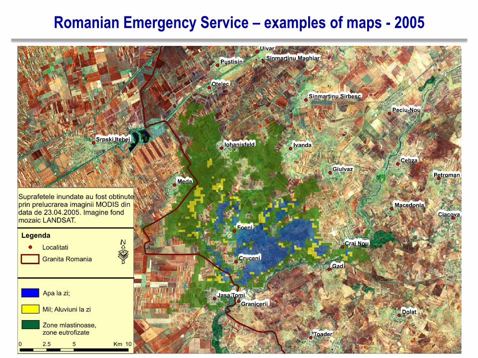
Romanian Emergency Service – examples of maps - 2005
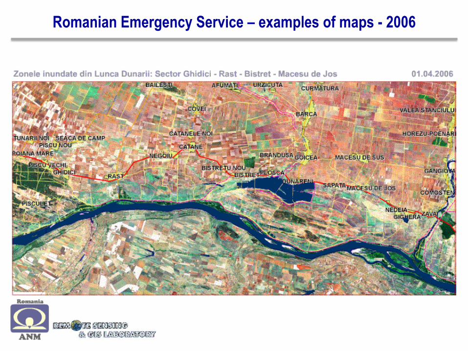
Romanian Emergency Service – examples of maps - 2006

Romanian Emergency Service – examples of maps - 2006

Romanian Emergency Service – examples of maps - 2008
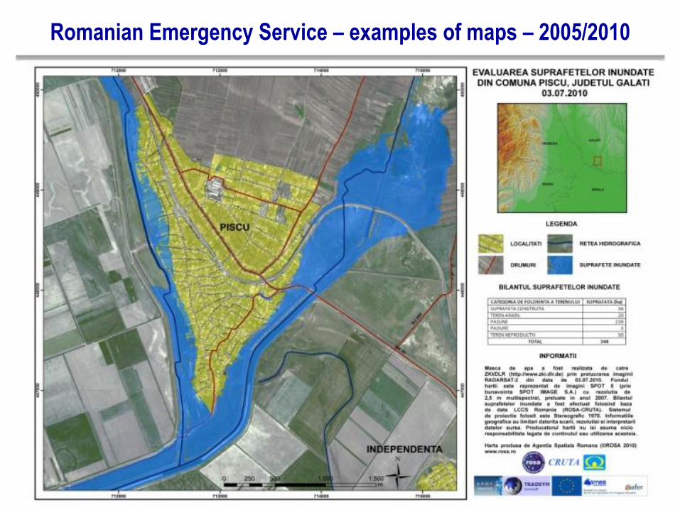
Romanian Emergency Service – examples of maps – 2005/2010
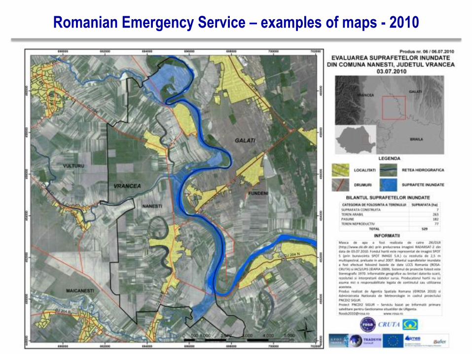
Romanian Emergency Service – examples of maps - 2010
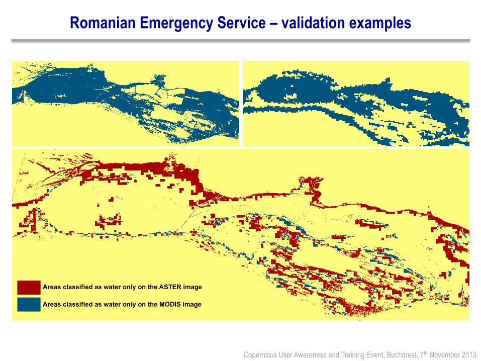
Romanian Emergency Service – validation examples
Copernicus User Awareness and Training Event, Bucharest, 7th November 2013
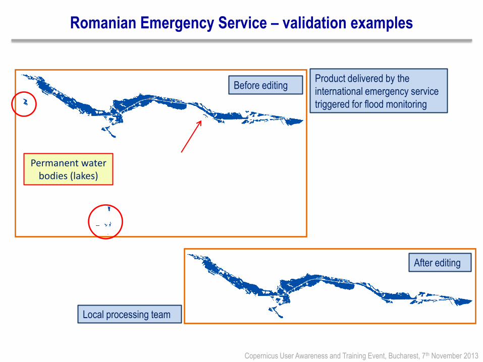
Romanian Emergency Service – validation examples
Copernicus User Awareness and Training Event, Bucharest, 7th November 2013
Before editing Product delivered by the
international emergency service
triggered for flood monitoring
Permanent water bodies (lakes)
After editing
Local processing team
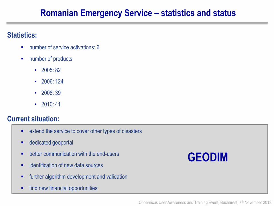
Romanian Emergency Service – statistics and status
Statistics:
number of service activations: 6
number of products:
• 2005: 82
• 2006: 124
• 2008: 39
• 2010: 41
Current situation:
extend the service to cover other types of disasters
dedicated geoportal
better communication with the end-users
identification of new data sources
further algorithm development and validation
find new financial opportunities
Copernicus User Awareness and Training Event, Bucharest, 7th November 2013
GEODIM
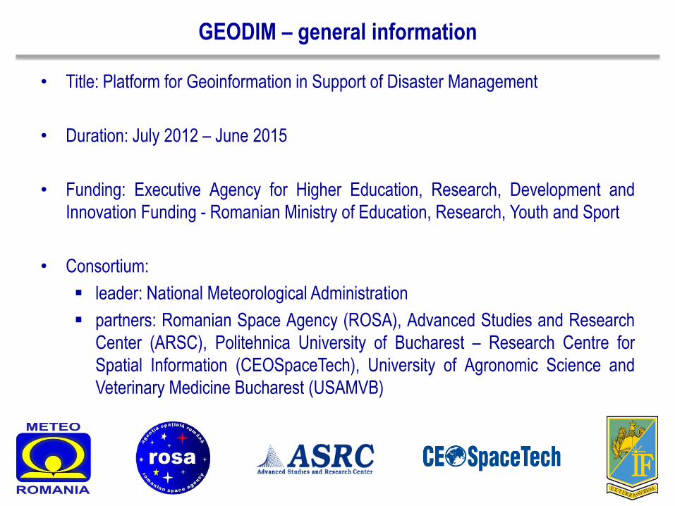
GEODIM – general information
• Title: Platform for Geoinformation in Support of Disaster Management
• Duration: July 2012 – June 2015
• Funding: Executive Agency for Higher Education, Research, Development and
Innovation Funding - Romanian Ministry of Education, Research, Youth and Sport
• Consortium:
leader: National Meteorological Administration
partners: Romanian Space Agency (ROSA), Advanced Studies and Research
Center (ARSC), Politehnica University of Bucharest – Research Centre for
Spatial Information (CEOSpaceTech), University of Agronomic Science and
Veterinary Medicine Bucharest (USAMVB)
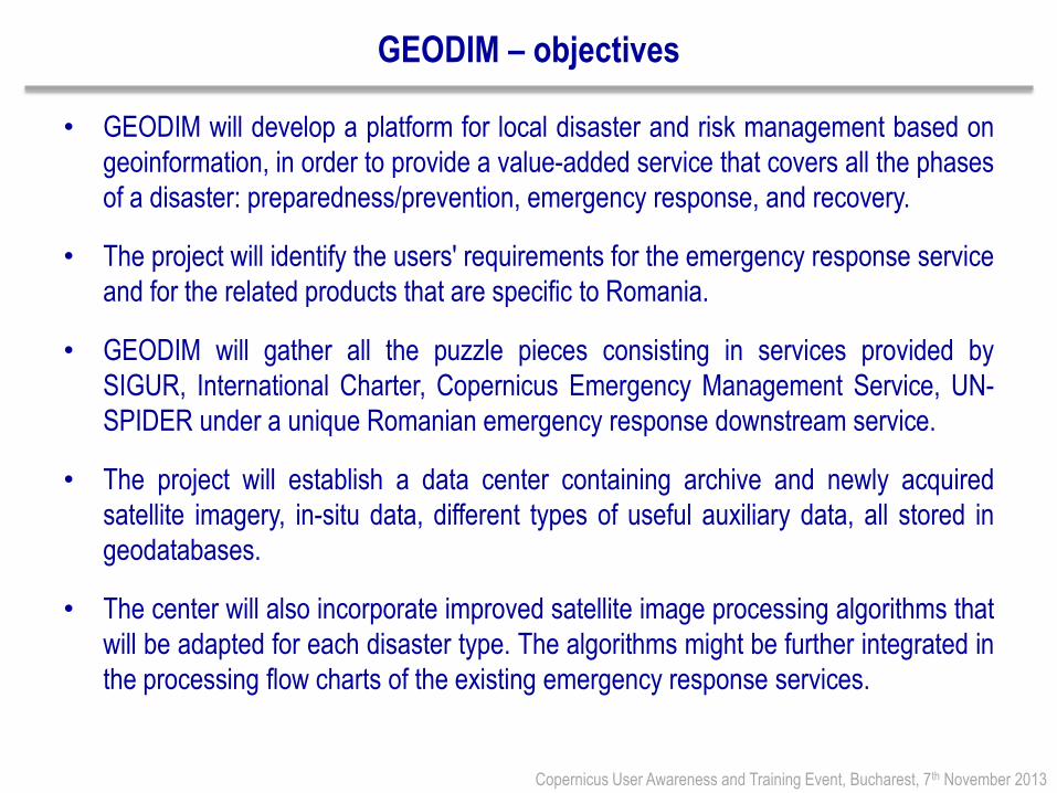
GEODIM – objectives
• GEODIM will develop a platform for local disaster and risk management based on
geoinformation, in order to provide a value-added service that covers all the phases
of a disaster: preparedness/prevention, emergency response, and recovery.
• The project will identify the users' requirements for the emergency response service
and for the related products that are specific to Romania.
• GEODIM will gather all the puzzle pieces consisting in services provided by
SIGUR, International Charter, Copernicus Emergency Management Service, UN-
SPIDER under a unique Romanian emergency response downstream service.
• The project will establish a data center containing archive and newly acquired
satellite imagery, in-situ data, different types of useful auxiliary data, all stored in
geodatabases.
• The center will also incorporate improved satellite image processing algorithms that
will be adapted for each disaster type. The algorithms might be further integrated in
the processing flow charts of the existing emergency response services.
Copernicus User Awareness and Training Event, Bucharest, 7th November 2013
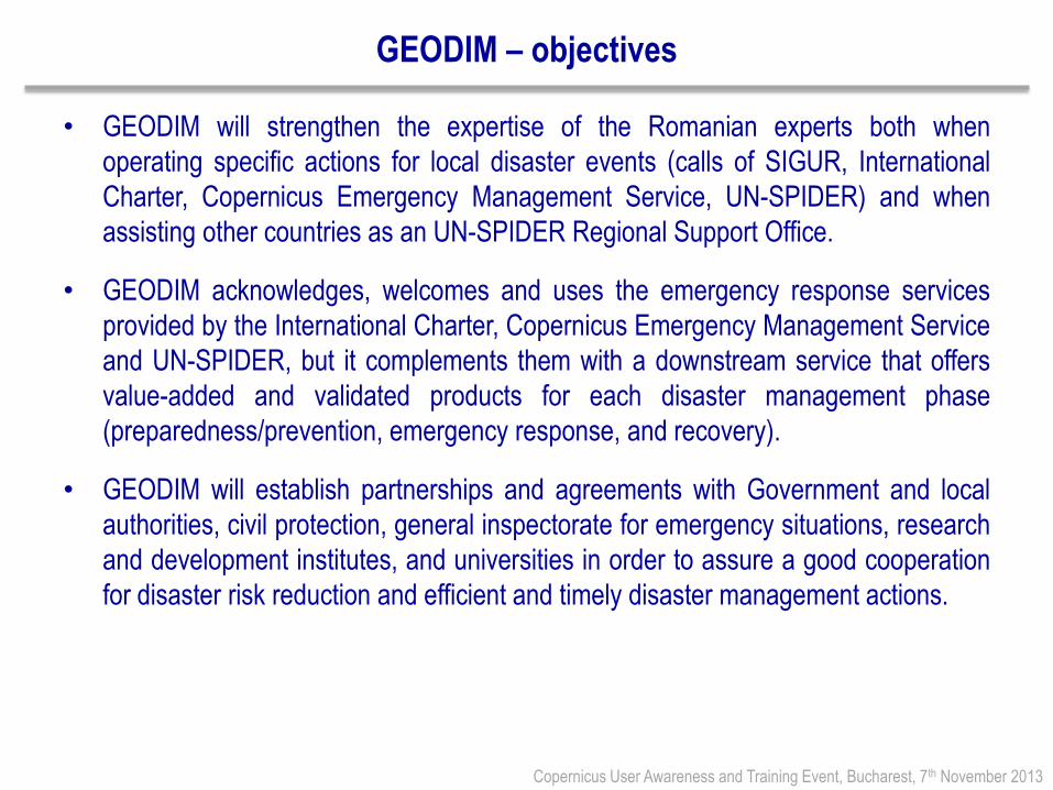
GEODIM – objectives
• GEODIM will strengthen the expertise of the Romanian experts both when
operating specific actions for local disaster events (calls of SIGUR, International
Charter, Copernicus Emergency Management Service, UN-SPIDER) and when
assisting other countries as an UN-SPIDER Regional Support Office.
• GEODIM acknowledges, welcomes and uses the emergency response services
provided by the International Charter, Copernicus Emergency Management Service
and UN-SPIDER, but it complements them with a downstream service that offers
value-added and validated products for each disaster management phase
(preparedness/prevention, emergency response, and recovery).
• GEODIM will establish partnerships and agreements with Government and local
authorities, civil protection, general inspectorate for emergency situations, research
and development institutes, and universities in order to assure a good cooperation
for disaster risk reduction and efficient and timely disaster management actions.
Copernicus User Awareness and Training Event, Bucharest, 7th November 2013

GEODIM – activities
GEODIM – products
• Reference maps: geographic maps containing information regarding the
topography (contour lines, benchmarks, digital elevation/surface models),
hydrology, and transport networks, localities, others. These maps shall be available
in a digital form (as GIS info-layers) before the beginning of crisis situation. The
scale-map will be 1: 100 000. Depending of the type of disaster, affected territory
and severity, maps with higher scales would be used (1: 50 000, 1: 25 000). The
existence of reference maps will be done by using the existing geospatial database
and cooperation with responsible institutions.
• Situation maps: maps that are critical for intervention teams and decision-making
committee. They are drawn-up through updating and completion of geographical
maps with specific information. During a crisis, depending of the disaster dynamic,
the situation-maps could face several up-dates (Ex: state of infrastructure,
meteorological conditions, extension of affected area). These maps will be set-up in
a standardized manner and distributed either in electronic form or printed. Because
the time is playing a major role during the decision-making stage, the situation-
maps generated during the disaster crisis (emergency response phase) shall be
promptly delivered, preferably maximum 24 hours after disaster starts-up.
Copernicus User Awareness and Training Event, Bucharest, 7th November 2013
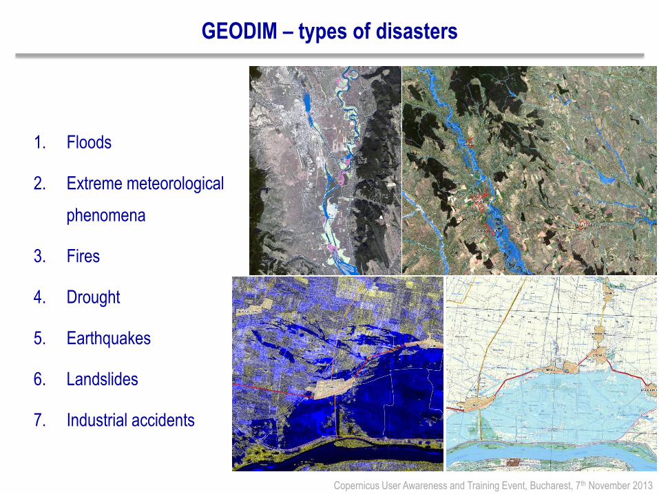
GEODIM – types of disasters
1. Floods
2. Extreme meteorological
phenomena
3. Fires
4. Drought
5. Earthquakes
6. Landslides
7. Industrial accidents
Copernicus User Awareness and Training Event, Bucharest, 7th November 2013
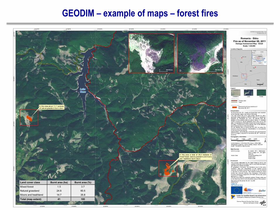
GEODIM – example of maps – forest fires
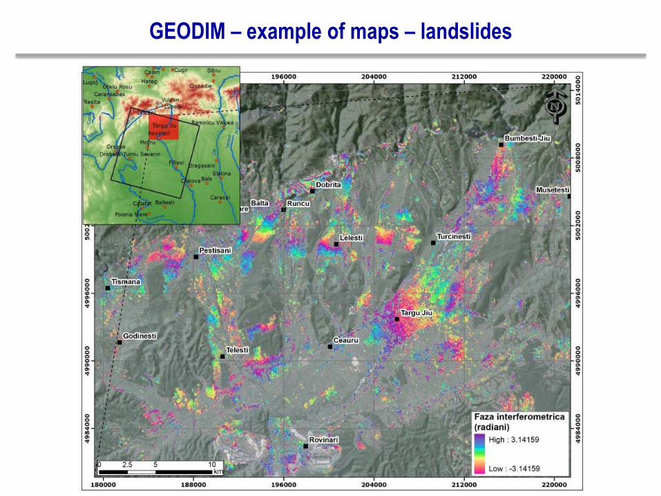
GEODIM – example of maps – landslides
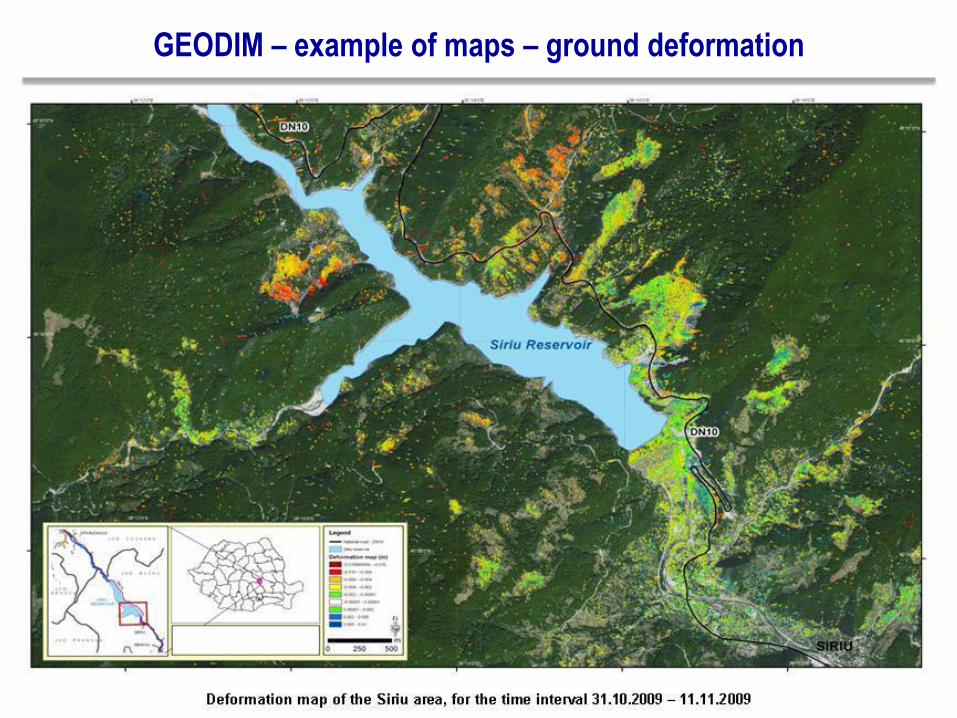
GEODIM – example of maps – ground deformation
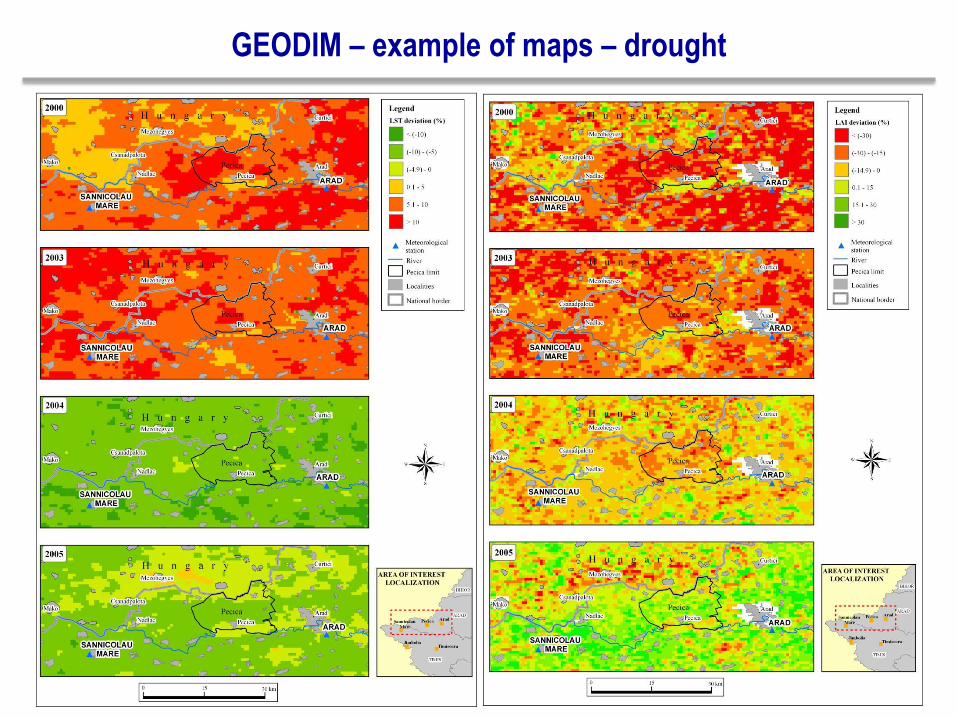
GEODIM – example of maps – drought
Romanian Emergency Services – conclusions
• Satellite remote sensing data and its derived products (space-based maps) are
essential components in the management of emergency situations.
• The integration of ancillary data improves the quality and content of the disaster
crisis maps offering the guarantee of the in situ collected basic information.
• From the user's point of view:
satellite data should be received as fast as possible
both temporal and spatial resolution are critical, but (at least) in the first phases
of the crisis situation temporal resolution is more important than spatial
resolution
Copernicus User Awareness and Training Event, Bucharest, 7th November 2013
GEODIM – conclusions
• The downstream emergency response service will be designed and implemented
according with the specific Romanian conditions that are defined by the final users
(Ministry of Environment, General Inspectorate for Emergency Situations), and
further integrated with the National System for Emergency Situations Management.
• GEODIM will provide an operational and validated service that will help the
responsible authorities to use the products during all stages of the crisis
management cycle (preparedness/ prevention, response, recovery), as a support
for their decision-making actions.
• The establishment and implementation of this downstream service would represent
an absolute first performance for Romania, fitting the current European policies and
trends related to Copernicus Downstream Services that are an extension of the
Emergency Response Core Service.
Copernicus User Awareness and Training Event, Bucharest, 7th November 2013