Geography 12 Resource Exam B Data Page 1
51°1
5’N
9899 919293949597 96
116°
30’W
4847
4950
5152
5354
5556
5758
Met
res
1000
M
etre
s10
00
0
La
ke
Lo
uis
eA
LB
ER
TAS
CA
LE 1
:50,
000
ÉC
HE
LLE
CO
NTO
UR
INT
ER
VA
L 40
ME
TR
ES
Ele
vatio
ns in
Met
res
Abo
ve M
ean
Sea
Lev
el
Data Page 2 Geography 12 Resource Exam B
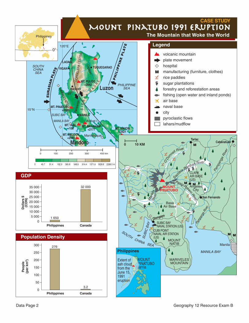
Mount Pinatubo 1991 EruptionThe Mountain that Woke the World
CASE STUDY Timeline of Major Events
1992July 16, 1990
7.8 earthquake
April 1991
Magma begins to rise in Mount Pinatubo.
June 12, 1991
Philippine Independence Day, interrupted by
first eruption.
June 15, 1991
Pinatubo explodes with an ash cloud rising
35 km into the air.
Ashbelt encirclesthe globe in the
following months.The arrival of
Typhoon Yunya.
June 17, 1991
Mount Pinatubo explodes in the second largest eruption of the twentieth century.
Mid-day one week after the eruption.
Mudflow and lahars covered many homes.
Ash and heavy rains associated with Typhoon Yunya caused havoc in urban areas.
Cou
rtes
y of
U.S
. Geo
logi
cal S
urve
y
Cou
rtes
y of
U.S
. Geo
logi
cal S
urve
yC
ourt
esy
of U
.S. G
eolo
gica
l Sur
vey
Pho
to b
y Its
uo In
ouye
cou
rtes
y of
w
ww
.dai
lylif
e.co
m
6.0 °C
14.5°N, 121°EElevation: 14 m
J F M A M J J A S O N D–30
–20
–10
0
10
20
30
40
0
100
200
300
400
500
600
700
°C mm
Manila, Philippines
Average annual precipitation: 2026 mmMean temperature: 27 °C
Pinatubo eruption kills
800 people and over a
million animals. Tens of
thousands left displaced.
Manila News
U.S. Air Base and
Naval Base help evacuate
thousands; bases
abandoned due to
immense destruction.
Manila News
LAOAG
VIGAN
Alabat I.
Marinduque
SOUTHCHINASEA
PHILIPPINESEA
SUBIC BAY
MANILA BAY
TUGUEGARAO
MANILA
LEGAZPIMindoro
120°E
15°N
Cagayan
Agno
Pam
pang
aC
OR
DIL
LER
A C
ENTR
AL
ZAMBALES MTS.
MT. BANAHAW+2177
MT. HALCON+2585
MT. MAYON+2421
MT. TAAL+100
MT. PINATUBO+1660 S
IE
RR
A M
AD
REMT. PULOG
+2842
PH
ILIP
PIN
E P
LA
TE
Luzon
EU
RA
SIA
N P
LATE
BAGUIO
0 100 200 300 400 km
0 45.7 91.4 182.9 365.8 548.6 914.4 1371.6 1828.8 2286.0 m
0°
Philippines
Legend
volcanic mountainplate movementhospitalmanufacturing (furniture, clothes)rice paddiessugar plantationsforestry and reforestation areasfishing (open water and inland ponds)air basenaval basecitypyroclastic flowslahars/mudflow
M
S
TarlacCabanatuan
San Fernando
Manila
MOUNTPINATUBO
AngelesCity
BasaAir Base
Olongapo
SUBIC BAYNAVAL STATION (US)
CLARKAIR BASE (US)
CUBI POINTNAVAL AIR STATION (US)
MANILA BAY
SU
BIC
BAY
SOUTH CHINA SEA
Pam
pang
a R
iver
Mar
ella
Riv
er
O’D
on
nell R
iver
Sacob
ia-Bamban River
Pasig-Potrero River
Pam
pang
a Ri
ver
0 10 KM
Philippines
MOUNT PINATUBO
ManilaP
M
Extent ofash cloudfrom the June 15, 1991 eruption
M
M
M M
M
S
S
S SS
S
SS
MOUNTNATIB
MARIVELESMOUNTAIN
GDP
35 000
30 000
25 000
20 000
15 000
10 000
5 000
0
Do
llars
$(C
DN
)
Philippines
1 650
Canada
32 000
Population Density
300
250
200
150
100
50
0
Peo
ple
(p
er k
m2 )
Philippines
276
Canada
3.2
Geography 12 Resource Exam B Data Page 3
Mount Pinatubo 1991 EruptionThe Mountain that Woke the World
CASE STUDY Timeline of Major Events
1992July 16, 1990
7.8 earthquake
April 1991
Magma begins to rise in Mount Pinatubo.
June 12, 1991
Philippine Independence Day, interrupted by
first eruption.
June 15, 1991
Pinatubo explodes with an ash cloud rising
35 km into the air.
Ashbelt encirclesthe globe in the
following months.The arrival of
Typhoon Yunya.
June 17, 1991
Mount Pinatubo explodes in the second largest eruption of the twentieth century.
Mid-day one week after the eruption.
Mudflow and lahars covered many homes.
Ash and heavy rains associated with Typhoon Yunya caused havoc in urban areas.
Cou
rtes
y of
U.S
. Geo
logi
cal S
urve
y
Cou
rtes
y of
U.S
. Geo
logi
cal S
urve
yC
ourt
esy
of U
.S. G
eolo
gica
l Sur
vey
Pho
to b
y Its
uo In
ouye
cou
rtes
y of
w
ww
.dai
lylif
e.co
m
6.0 °C
14.5°N, 121°EElevation: 14 m
J F M A M J J A S O N D–30
–20
–10
0
10
20
30
40
0
100
200
300
400
500
600
700
°C mm
Manila, Philippines
Average annual precipitation: 2026 mmMean temperature: 27 °C
Pinatubo eruption kills
800 people and over a
million animals. Tens of
thousands left displaced.
Manila News
U.S. Air Base and
Naval Base help evacuate
thousands; bases
abandoned due to
immense destruction.
Manila News
LAOAG
VIGAN
Alabat I.
Marinduque
SOUTHCHINASEA
PHILIPPINESEA
SUBIC BAY
MANILA BAY
TUGUEGARAO
MANILA
LEGAZPIMindoro
120°E
15°N
Cagayan
Agno
Pam
pang
aC
OR
DIL
LER
A C
ENTR
AL
ZAMBALES MTS.
MT. BANAHAW+2177
MT. HALCON+2585
MT. MAYON+2421
MT. TAAL+100
MT. PINATUBO+1660 S
IE
RR
A M
AD
REMT. PULOG
+2842
PH
ILIP
PIN
E P
LA
TE
Luzon
EU
RA
SIA
N P
LATE
BAGUIO
0 100 200 300 400 km
0 45.7 91.4 182.9 365.8 548.6 914.4 1371.6 1828.8 2286.0 m
0°
Philippines
Legend
volcanic mountainplate movementhospitalmanufacturing (furniture, clothes)rice paddiessugar plantationsforestry and reforestation areasfishing (open water and inland ponds)air basenaval basecitypyroclastic flowslahars/mudflow
M
S
TarlacCabanatuan
San Fernando
Manila
MOUNTPINATUBO
AngelesCity
BasaAir Base
Olongapo
SUBIC BAYNAVAL STATION (US)
CLARKAIR BASE (US)
CUBI POINTNAVAL AIR STATION (US)
MANILA BAY
SU
BIC
BAY
SOUTH CHINA SEA
Pam
pang
a R
iver
Mar
ella
Riv
er
O’D
on
nell R
iver
Sac
obia-Bamban River
Pasig-Potrero River
Pam
pang
a Ri
ver
0 10 KM
Philippines
MOUNT PINATUBO
ManilaP
M
Extent ofash cloudfrom the June 15, 1991 eruption
M
M
M M
M
S
S
S SS
S
SS
MOUNTNATIB
MARIVELESMOUNTAIN
GDP
35 000
30 000
25 000
20 000
15 000
10 000
5 000
0
Do
llars
$(C
DN
)
Philippines
1 650
Canada
32 000
Population Density
300
250
200
150
100
50
0
Peo
ple
(p
er k
m2 )
Philippines
276
Canada
3.2
Data Page 4 Geography 12 Resource Exam B
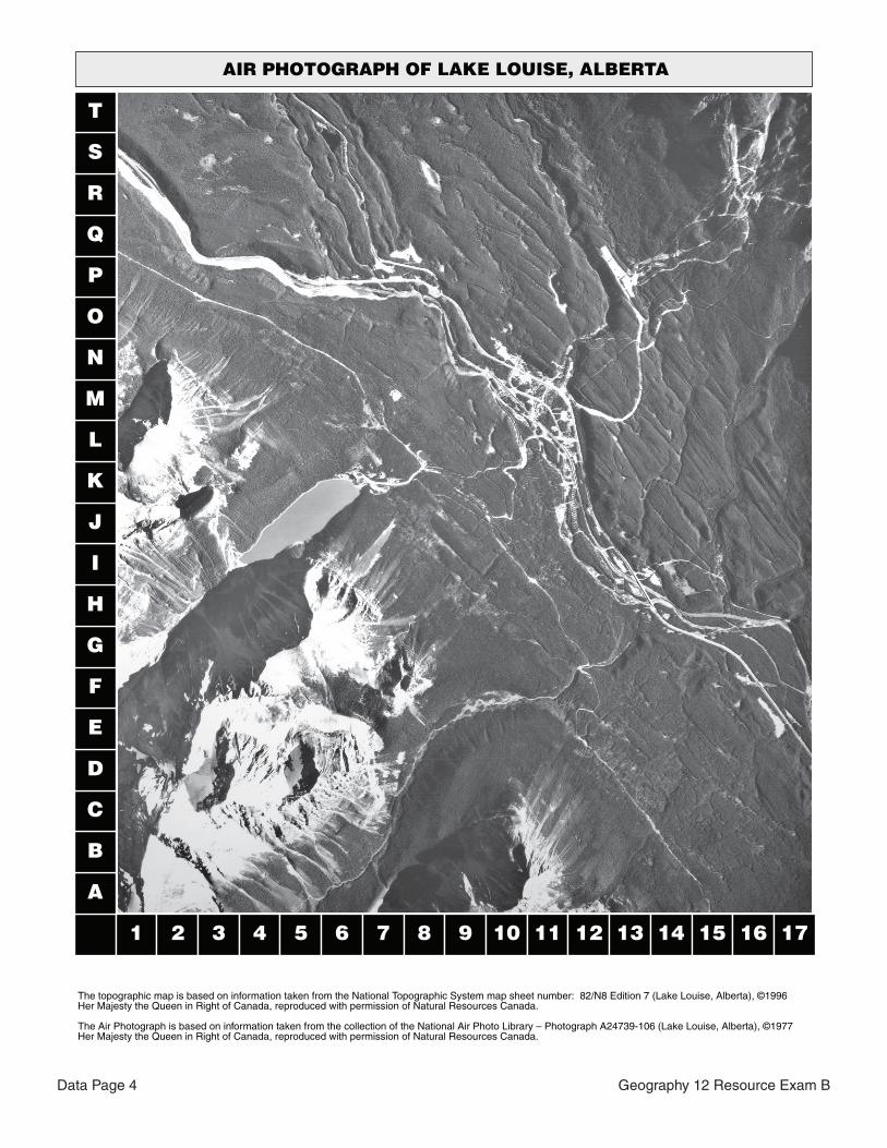
AIR PHOTOGRAPH OF LAKE LOUISE, ALBERTA
1 2 3 4 5 6 7 8 9 10 11 12 13 14 15 16 17
A
B
C
D
E
F
G
H
I
J
K
L
M
N
O
P
Q
R
S
T
The topographic map is based on information taken from the National Topographic System map sheet number: 82/N8 Edition 7 (Lake Louise, Alberta), ©1996Her Majesty the Queen in Right of Canada, reproduced with permission of Natural Resources Canada.
The Air Photograph is based on information taken from the collection of the National Air Photo Library – Photograph A24739-106 (Lake Louise, Alberta), ©1977 Her Majesty the Queen in Right of Canada, reproduced with permission of Natural Resources Canada.