2. 19942 41P11SE2023 2.19942 TYRRELL 010 ROY LACARTE PROPERTY GEOLOGICAL EVALUATION CLAIM 1226851 TYRRELL TOWNSHIP TIMISKAMING DISTRICT, NORTHEASTERN ONTARIO December 2 , 1999 by Walter Hanych
Transcript
2. 1994241P11SE2023 2.19942 TYRRELL
010
ROY LACARTE
PROPERTY
GEOLOGICAL EVALUATION
CLAIM 1226851
TYRRELL TOWNSHIP
TIMISKAMING DISTRICT, NORTHEASTERN ONTARIO
December 2 , 1999
by
Walter Hanych
Table of Contents
page
Introduction.................................................................................................................................^Location and Access.....................................................................................................................2Property Description and Tenure..................................................................................................2Previous Work and History..........................................................................................................2Regional Geology.........................................................................................................................2Economic Geology.......................................................................................................................31999 Exploration Program...........................................................................................................4Recommendations........................................................................................................................4
Certificate of Qualifications.........................................................................................................^
During the summer of 1999, Mr. Roy Lacarte of Englehart, Ontario undertook a program of trenching and stripping on his mineral claim situated in Tyrrell Township .At his request the author of this report was commissioned to undertake a geological evaluation of the trenching and stripping. The following report of his activities and geological observations was generated from a site to visit to the property on October 2nd , 1999.
LOCATION and ACCESS
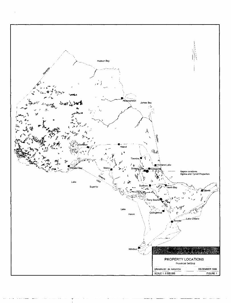
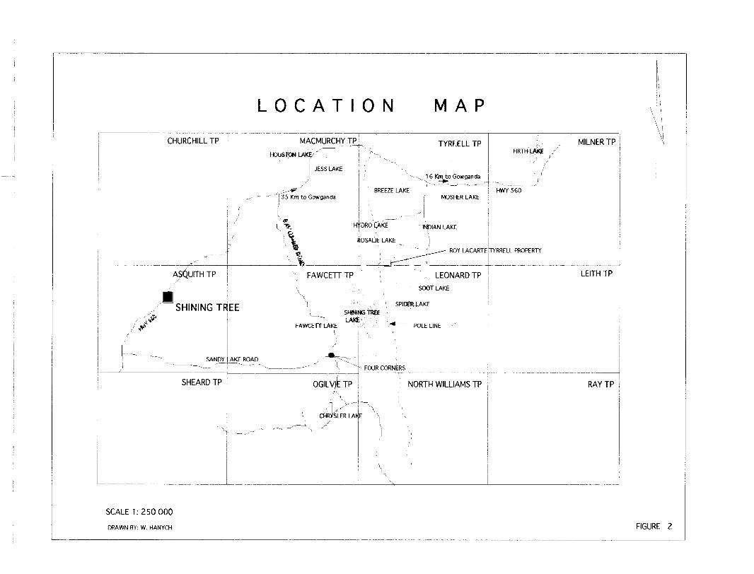
The property is located in southwest portion of Tyrrell Township in NTS quadrant 41PNW at UTM co-ordinate 496500E, 52&OOOON in the Shining Tree-Gowganda area of northeastern Ontario. Gowganda is a small community located on highway 560 approximately 120 kilometers north of Sudbury. Access to the property is easily gained by driving westward from Gowganda for 16 kilometers to the intersection of the Indian Lake road. Then, in a general southward direction for 5.6 kilometers past the east side of Indian Lake to the fork that leads southward to Soot Lake and westward to Rosalie Lake and Hydro Lake. The west fork is taken to for 1.5 kilometers to Rosalie Lake. Form this point a 1.5 kilometer ATV or walking trail leads to the eastern end of the property, (see figure 1)
PROPERTY DESCRIPTION and TENURE
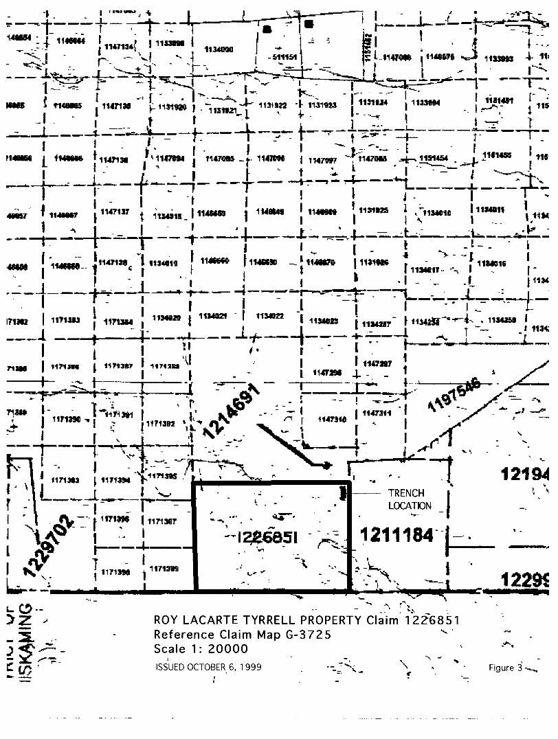
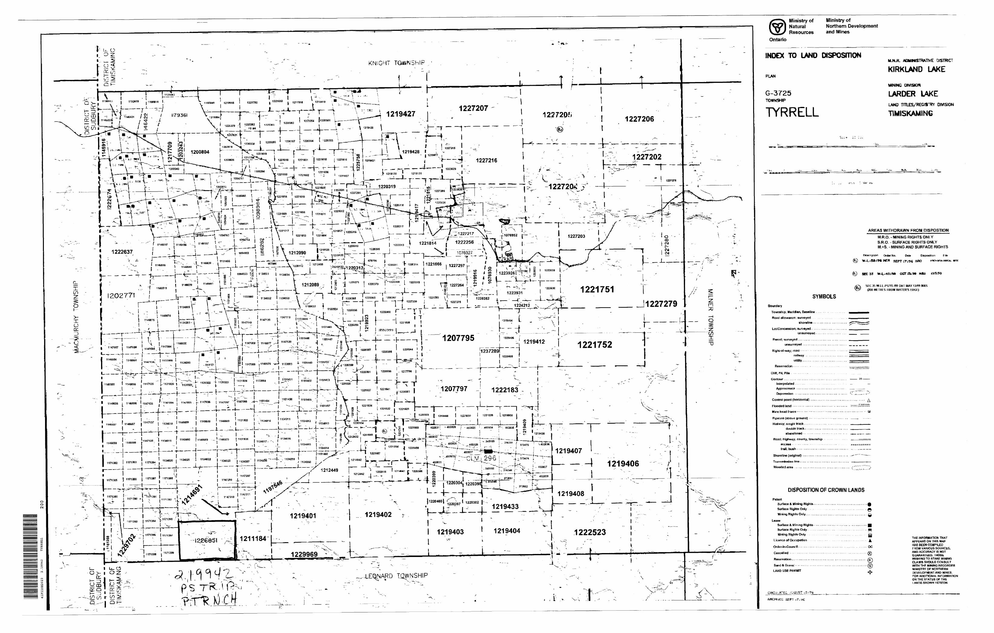
The property consists of one 2x3 claim totaling approximately 96 hectares registered under claim number 1226851. (see figure 2)
The unpatented mining claim was staked in accordance with the Ontario Mining Act and has been recorded with the Larder Lake Mining Division; Ministry of Northern Development and Mines on claim map G 3725. The claim retains clear title and is currently in good standing with assessment work requirements to be fulfilled by May 25th , 2000
PREVIOUS WORK and HISTORY
In the past, exploration in southwest Tyrrell Township was largely pick and shovel prospecting activity of the early 1900's, subsequent to the discovery of silver in Gowganda. The remainder of Tyrrell Township has been heavily explored for gold especially since the Native Land Caution was resolved in the early 1990's.
In 1999, Mr. Roy Lacarte undertook an extensive prospecting program of trenching and stripping of his claim. The contact zone between the Nipissing gabbro and underlying Archean was the target of his activities.
REGIONAL GEOLOGY
The Shining Tree-Gowganda area is situated within the Abitibi greenstone belt, the largest greenstone belt in the world hosting a wealth of mineral deposits. The Abitibi greenstone belt is composed of Archean rocks that in general terms are subdivided into two broad assemblages, a lower Keewatin aged (2.75-2.70 Ga) metavolcanics and metasediments consisting of mafic to intermediate to felsic flows and clastic rocks containing komatiitic flows and synvolcanic granodioritic intrusions and a later, Timiskaming aged (2.70-2.60 Ga) package of rocks, that includes large batholiths of foliated and massive granodiorite, granite and feldspar-quartz porphyry, and alluvial-fluvial clastic metasedimentary rocks and alkalic metavolcanic rocks.
W. Hanych December 3, 1999 Page 2 of 6
"—— Approx locationsOgilvie and Tyrrell Properties
PROPERTY LOCATIONSProvincial Setting
LOCATION MAP
CHURCHILL TP MACMURCHY TF^ TYRF.ELL TPHOUSTON LAKE J~ -
1 S ' " --.
JESS LAKE
^ —— - - 1 35 K^,, to Gowgandaj
1 - v 16 Km to Gowganda
BREEZE LAKE | i MOSHER LAKE
.
MILNER TPFIRTH UWJE /'
- i
HWY 560
l ' ~Jt. H1 'ORO l^\KE INDIAN LAKE
^ xi ' \ \^ IIOSAIJE LAKE \
\
' *L "~~J'^-—- ROY LACARTE TYRRELL PROPERTY S \. ' r-ui-— — ~^~~^~~^
ASOJJITHTP , FAWCETT TP : LEONARD TP LEITH TP! ( SOOT LAKE
1 : \ . ' ! - i, SHINING TREE ! .^r** SPIDERLAKE '
ffi _ -
\ ~~ ~^-. s SANDY
SHEARD TP
FAWCETT LAKE '"* ——— POLE LINE " ;\ ' ' i
-AKE^ROAD , Vr;;:i~ ~
1 ————————— —————— -——j —— —— - FOUR CORNERS
OGILVjkTP : NORTH WILLIAMS TP
- CHRXSLER LAh
——— ——- ^-.... ..,~^.y-———— "-^.X
\ '
RAY TP
';
i i
sxj
SCALE 1:250000
DRAWN BY: W. HANYCH FIGURE 2
T i l t "Vi W w f'J ,^ Jlf713K
-* *r x
ROY LACARTE TYRRELL PROPERTY Claim 1226851 Reference Claim Map G-3725 v Scale 1: 20000ISSUED OCTOBER 6, 1 999 v... \ Figure 3
The southern portion of the Abitibi greenstone belt can be subdivided into belts, the Shining Tree greenstone belt and the Swayze greenstone belt.
Within the Shining Tree belt, the regional strike of the rocks is in a general east-west direction. Local abrupt changes from the regional trend, result in an angular juxtapositioning of trends complicating stratigraphic and facies relationships. To date, the Archean rocks have been divided into two packages, a lower package of mafic-felsic metavolcanics, komatiitic flows and associated clastic metasediments (Keewatin age) and a package of unknown age, disconformably overlying the previously mentioned package, consisting of intermediate pyroclastic and epiclastic metasediments, the Indian Lake group.
The older volcanics are chemically classified into tholeiitic, calc-alkaline and komatiitic suites while the younger volcanics are classified as alkalic and are comparable to the Timiskaming Group. Intermediate porphyry dikes, sills and sheets have been intruded into the above and alkalic -subalkalic syenite and monzonite sills and dikes are common.
Southeast of Tyrrell Township, the Archean rocks are unconformably overlain by the Huronian Supergroup metasediments, which occupy a large regional structure, referred to as the Cobalt embayment. The embayment is a fault bounded basil structure, with the Duncan Lake fault having controlled its western boundary.
The above have been intruded by Paleoproterozoic age (2.5-1.6 Ga), north to northwest trending Matachewan diabase dike swarms and by Nipissing gabbro dikes and sills.
Northwest trending faults are the most common and often offset stratigraphy. The most prominent faults are the Jess Lake fault in east MacMurchy Township, the Hydro Creek fault in west Tyrrell Township and the Duncan Lake fault in east Tyrrell Township.
ECONOMIC GEOLOGY
In the Shining Tree greenstone belt, unconformable contact relationships between older volcanics and younger sediments have been recently identified. Major breaks or shear zones develop along these contacts which define basin edges and are host to numerous gold showings and a number of small deposits.
The Ronda Mine produced 2,727 ounces of gold from the Ribble vein. While the Tyrranite mine produced 31,352 ounces of gold from a north-south fracture-shear zone. Approximately 223,810 tons of material grading 0.140 oz/T was mined. A known resource of 200,000 tonnes exists on the property. The Duncan Lake-Minto deposit contains a resource of 206,000t grading 6.86 g/t Au. Gold mineralization is hosted in a brecciated felsic porphyry that forms an oval pipe related to a diatreme. The Welsh-Regan-Jouby showing recently acquired by INMET is a 300 meter long carbonate schist shear zone spatially associated with Timiskaming type sediments and contains lenticular bodies of pyritic quartz that assay up to 3.5 g/t Au over 21.8 meters from drill holes.
The Cobalt Embayment contains numerous silver showings and deposits in proximity to the Archean-Huronian unconformity with possibly the Nipissing gabbro contact zone. Silver-cobalt-nickel mineralization is associated with silver arsenides in quartz-carbonate filled tension fractures. In Tyrrell Township no significant silver production has occurred.
W. Many eh December 3, 1999 Page 3 of 6
1999 EXPLORATION PROGRAM
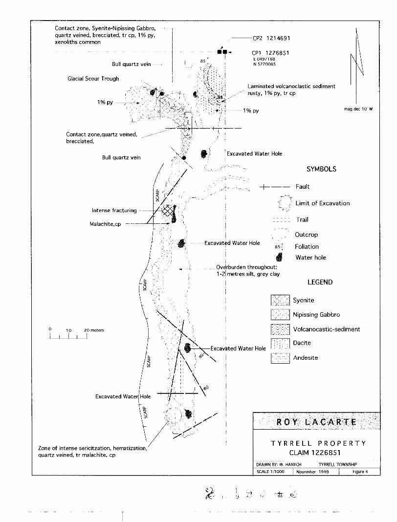
Between July 1 st and September 3 rd 1999, Mr. Roy Lacarte stripped and trenched the eastern contact zone of large body of Nipissing gabbro. A stripped area measuring 200 meters in length and averaging 15 meters in width was cleared utilizing a 941 Caterpillar dozer and a Koehring Bantam C-186 track excavator. The washing of the outcrop was done in conjunction with the stripping-trenching. (see figure 3)
The scarp of this large Body of Nipissing gabbro was exposed and as the bedrock plunged drastically into overburden near the east claim boundary several 5 meter deep water holes revealed heavy overburden composed of 1-2 meters of sand-silt followed by glacio lacustrine clays.
Although the actual contact was never observed the Nipissing gabbro displayed sericitization, hematization and chalcopyrite mineralization proximal to the contact area. Near the number one claim post a stripped area uncovered Archean volcanics and sediments. The sediments were tightly folded about a north-south fold axis that plunged at 55" to the south. Sulphide mineralization within this package of rocks amounted to 19fc pyrite and trace chalcopyrite.
The contact zone between andesite and syenite contained unmineralized bull quartz veins and lenses.
RECOMMENDATIONS
No significant mineralization was observed in the exposed rocks. The north and east claim boundaries lie within one to twenty meters of this stripping leaving very little room for further exploration to the north and east. As it stands, the claim should be prospected to the west before any further stripping is contemplated.
Zone of intense sericitzation, hematization, quartz veined, tr malachite, cp
TYRRELL PROPERTY CLAIM 1226851
TYRRELL TOWNSHIP
SCALE 1:1000 November 1999 Figure 4
1 i -:-1 It i-.-
CERTIFICATE of QUALIFICATION
I Walter Hanych of the town of Collingwood, Province of Ontario, do hereby certify that:
1. I am a geologist and reside at RR # 3 Collingwood, Ontario, L9Y-3Z3. Telfax 705 445 6440
2. I graduated from Laurentian University in 1979, with an Honours Degree of Bachelor of Science in Geology.
3. I have been practicing my profession since graduation and that I am a Fellow of the Geological Association of Canada and a member of the Association of Geoscientists of Ontario.
4. I have not received, any interest direct or indirect, in the properties or securities held by Mr. R. Lacarte or any affiliate.
5. I consent to the use of this report in submissions for assessment credits or similar regulatory requirements, and to regulatory authorities.
6. That I am the author of this report and inspected the field operations, and the collection of data from which this report is generated.
LWalter Hanych
W. Hanych December 3, 1999 Page 5 of 6
REFERENCES
Baker, C, L., et al. 1995, Report of Activities 1995, Resident Geologists; OntarioGeological Survey, Open File Report 5943, 393p.
Carter, M. W., 1987 Ontario Geological Survey Report 240, Geology of the ShiningTree Area, District of Sudbury and Timiskaming, Mines and Mineral Division, Ministry of Northern Development and Mines, 41p.
Ekstrand, O.R., et al., 1995 Geology of Canadian Mineral Deposit Types, Geology ofCanada no. 8. Geological survey of Canada, 640p.
Thuston, P.C., et al., 1991 Geology of Ontario, Special Volume 4, Ontario GeologicalSurvey, Ministry of Northern Development and Mines, 1525p.
W. Hanych December 3, 1999 Page 6 of 6
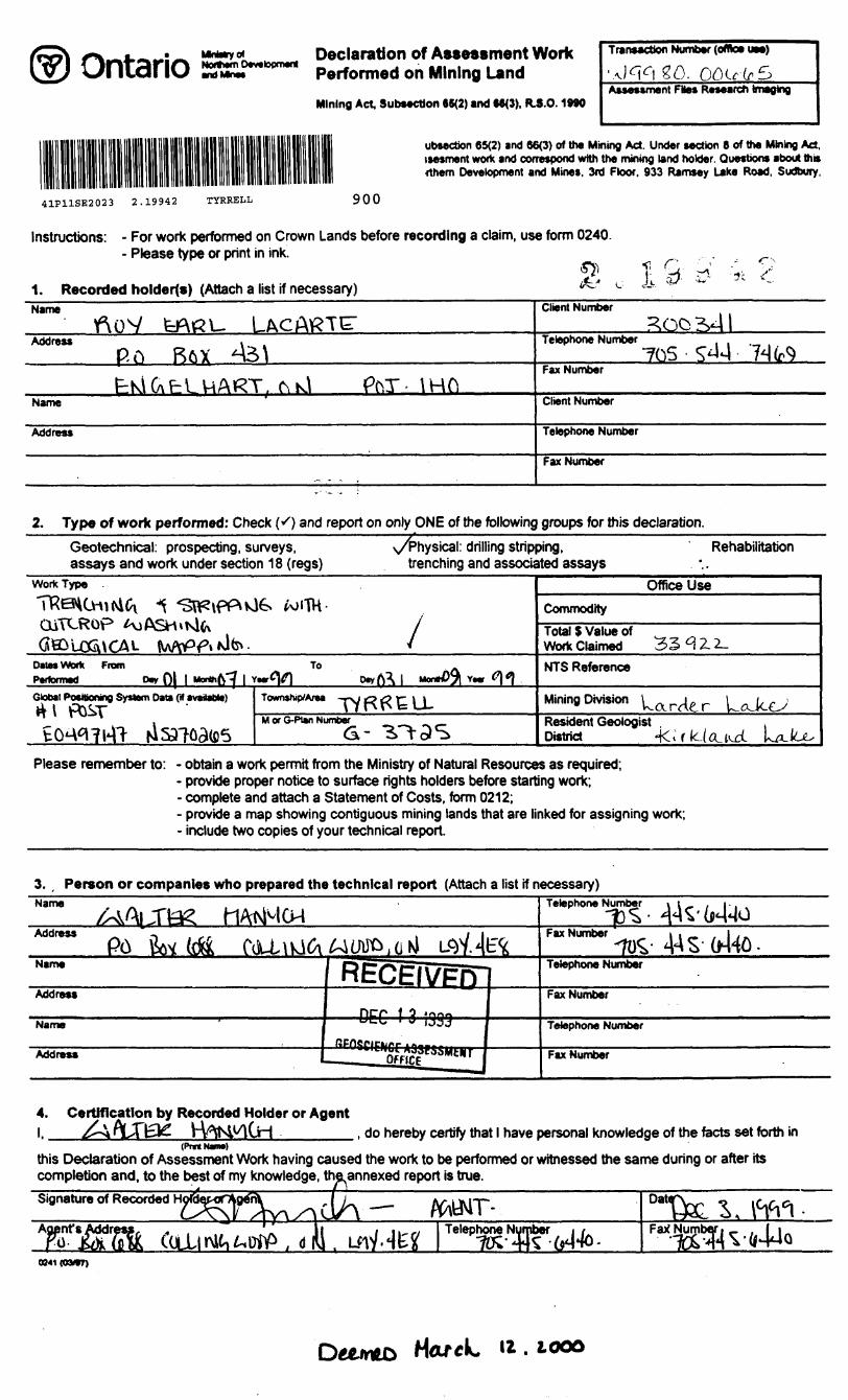
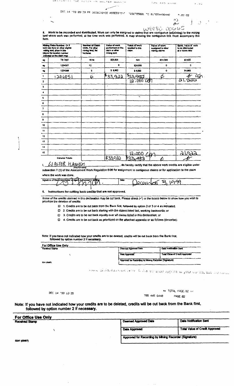
Ontario Declaration of Assessment WorkHo*jmO*v.lopm*ni performe(| Qn Mining Land
Mining Act Subsection 65(2) and MO). R.3.O.1*90
Transaction Number (office UM)
go.Assessment FSes Research Imaging
ubsection 65(2) and 66(3) of the Mining Act. Under section 6 of the Mining Act. isesment work and correspond with the mining land holder. Questions about this (them Development and Mines, 3rd Floor. 933 Ramsey Lake Road, Sudbury,
41P11SE2023 2.19942 TYRRELL 900
Instructions: - For work performed on Crown Lands before recording a claim, use form 0240. - Please type or print in ink
1. Recorded holders) (Attach a list if necessary)Name
Address . P ft RftX *A3\
^K\C\PLUART. C\K\ PhT- IHftName
Address
.
Client Number I? QQj 2s*J l
Telephone Number^•l 74 (rS
Fax Number
Client Number
Telephone Number
Fax Number
2. Type of work performed: Check K) and report on only ONE of the following groups for this declaration.^^^^^^v/rhysical: drilling stripping, RehabilitationGeotechnical: prospecting, surveys,
assays and work under section 18 (regs) trenching and associated assaysWork TypeTTREHC OiTCROp
joiTH-1
*
Office UseCommodityTotal 5 Value of Work Claimed 33 H Z 2.
DMMWork From Pwformad
To NTS Reference
Global Positioning System Data (H •vaitable) Mining DivisionM or G-Ptan Number Resident Geologist
District -
Please remember to: - obtain a work permit from the Ministry of Natural Resources as required;- provide proper notice to surface rights holders before starting work;- complete and attach a Statement of Costs, form 0212;- provide a map showing contiguous mining lands that are linked for assigning work;- include two copies of your technical report.
3. , Person or companies who prepared the technical report (Attach a list if necessary)Name
Address -, i i
Name
Address
Name
Address
fiECEIVPrT—— DEC 1 3 !339 ——
—— ̂ otiS11*^*^
Telephone Number i t - . i . 1)^' nTi'tPMHO
Fax Number i i — , 1 i -,-70^- 44S (H40-Telephone Number
Fax Number
Telephone Number
Fax Number
4. Certification by Recorded Holder or Agent l. ^\ nLH3^ V"W^m(jr-l . do hereby certify that l have personal knowledge of the facts set forth in
this Declaration of Assessment Work having caused the work to be performed or witnessed the same during or after its completion and. to the best of my knowledge, the annexed report is true.Signature of Recorded dAAopnfsPo
Telephone Nt r iber
0241 (OVST)
HOT*L
O ^ a a b t -i -i f)
DEC 1 4 '99 09179 FR GECSCIENCE flSSES3t"?sT
U^W^C. CO C* Co8. Work to t* recorded and distributed. Work can only be assigned to claims that are contiguous (adjoining) to the mining land where work was performed, at the time work was performed. A map showing the contiguous link must accompany this form.
MMns CWm Nomb*. Of t •orkwHdWM w (KMr dglbk rtMnglmd,ito*ilntN* Cwvm 1M M nilufl nvnbcf indcvtod on ttw cWm map.
•9
•B
•9
1
Z
J
4
S
s
7
t
S
10
11
12
13
14
15
TB7627
123*567
1ZMSM
\ 33 (b^5 1
Col unn ToOriB
HinibtfofCbkn UnM, For atar
18 ha
12
Z
6
VthMOtwwt
eWmorcVwr miring land
C6.825
0
t S.W2
^35 ^(5S
cMm.
N/A
C4.000
J4JXJCJ*
ia 'Ooo Ce
-
. latkooo T'^33/1 &J feaw*^ra^
Value of work iislgMd lo oswrnwilng cbimK.
C4.QOO
0
0
fi1
Y^
Bw*. vilu* of tmrx lobedMritxJlcd M i tutunt ditc
S2.B2S
0
*4^9I
-^ ^r3.\,S*3S
nll,0^^^-
., do hereby certify that the above work credits are eligible undersubsection 7 (1) of the Assessment Work Regulation 6/96 for assignment to contiguous claims or for application to the claimwtiere the work was done
6. Instructions for cutting back credits that are not approved.
Some of the credits daimed in this declaration may be cut back. Please check (-0 in the boxes below to show how you wish to prioritize the deletion of credits:
D 1. Credits are to be cut back from the Bank first, followed by option 2 or 3 or 4 as indicated,O 2. Credits are to be cut back starting with the claims listed last, working backwards; orD 3. Credits are to be cut back equally over atl claims listed in this declaration-, orO 4. Credits are to be cut back as prioritized on the attached appendix or as follows (describe):
Note: If you have not Indicated how your credits are to be deleted, credits will be cut back from the Bank first. followed by option number 2 if necessary.
For Office Us* OnlyRwAnd&tinp
\
024i (nor)
Domod Approve Dito
ra*.A*raMd
D*U Nattfcvfen S*4
ToMI VltM rf Crwtt Approved
*t*"w*d l* R*cw*ig by Mk*q Record* (Sign***)
DEC 14 '99 12:35to TOTPL FQGE.B2
445 6440 PPGE.02
Note: If you have not indicated how your credits are to be deleted, credits will be cut back from the Bank first, followed by option number 2 if necessary.
For Office Use Only___________________,Recttod Stvnp
02*1(03*7)
id Approved Otto
MaAppromd
Drte Nottficatton Swtf
Total Value of Credft Approved
Approved for Recording by MWng Recorder (Signature)
Ontario Ministry olNorthern Development nd Mine*
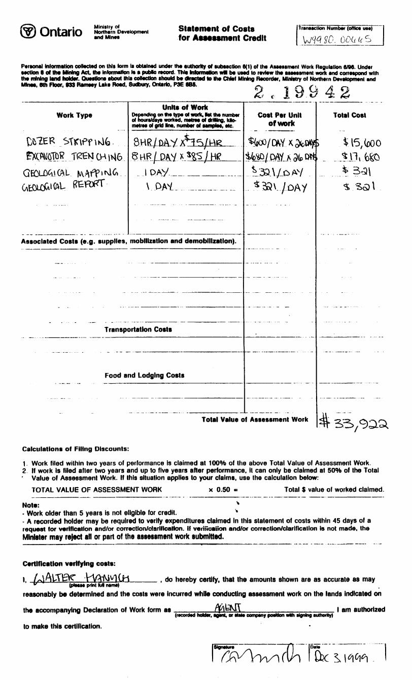
Statement of Costs for Assessment Credit
TrutMcilon Number (oHtce irae)
V/WSO.
Personal (nlormillon coated on Ihl* term li obtalmd under the authority ol subsection 6(1) ol Ihe Assessment Work Regulation e/M. Under section e of the Mining Act. the Information Is a pubte record. This Information wM b* used to review Ihe assessment work and correspond with Ihe mining tend holder. Questions bout Nils collection should be directed to the Chief Mlnmg Recorder, Ministry ol Northern Development and Mtnea, 6th Floor, 033 Ramsey Lake Bowl. Sudbury, Ontario, WE BBS. ^ -^ ,, -
2 , l 9.9 4 2Work Type
STK\Pf \hlfc.
Unite of WorkDepending on Hw type ol work, M Hw number d hours/days worked. metres of drHHng. Mo- metres ol grid Hot, number ol samples, ote.
S hLR /-DAY *
Associated Costs (e.g. supplies, mobilization and demobilization).
Transportation Costs
Food and Lodging Costs
Cost Per Unit of work
3a.V-.oAV 7 DAY
Total Value of Assessment Work
Total Cost
15, too o
Calculations of Filing Discounts:
1. Work filed within two years of performance is claimed at 100*ft of the above Total Value of Assessment Work.2 If work Is filed after two years and up to five years after performance, it can only be claimed at SOW of the Total' Value of Assessment Work. If this situation applies to your claims, use the calculation below:
TOTAL VALUE OF ASSESSMENT WORK x 0.50 Total S value of worked claimed.
Note: v- Work older than 5 years is not eligible for credit. *- A recorded holder may be required to verify expenditures claimed In this statement of costs within 45 days of a request tor verification and/or correction/clarification, if verification and/or correction/clarification Is not made, theMinister may reject all or part of the assessment work submitted.
Certification verifying costs:
l. AxV . do hereby certify, that (he amounts shown are as accurate as may(plMM print M name)
reasonably be determined and the costs were Incurred while conducting assessment work on the lands Indicated on
the accompanying Declaration of Work form as
lo make this certification.
(recorded hoUer, ageni, or stele with WQnlnQ Authority)l am authorized
l Signature ^ Dale"
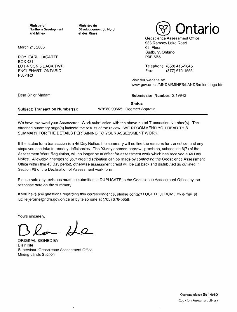
Ministry of Ministere duNorthern Development Developpement du Nordand Mines et des Mines Ontario
Geoscience Assessment Office 933 Ramsey Lake Road
March 21, 2000 6th FloorSudbury, Ontario
ROY EARL LACARTE P3E6B5BOX 431LOT 4 CON 5 DACK TWP. Telephone: (888) 415-9845ENGLEHART, ONTARIO Fax: (877)670-1555POJ-1HO
Status Subject: Transaction Number(s): W9980.00665 Deemed Approval
We have reviewed your Assessment Work submission with the above noted Transaction Number(s). The attached summary page(s) indicate the results of the review. WE RECOMMEND YOU READ THIS SUMMARY FOR THE DETAILS PERTAINING TO YOUR ASSESSMENT WORK.
If the status for a transaction is a 45 Day Notice, the summary will outline the reasons for the notice, and any steps you can take to remedy deficiencies. The 90-day deemed approval provision, subsection 6(7) of the Assessment Work Regulation, will no longer be in effect for assessment work which has received a 45 Day Notice. Allowable changes to your credit distribution can be made by contacting the Geoscience Assessment Office within this 45 Day period, otherwise assessment credit will be cut back and distributed as outlined in Section #6 of the Declaration of Assessment work form.
Please note any revisions must be submitted in DUPLICATE to the Geoscience Assessment Office, by the response date on the summary.
If you have any questions regarding this correspondence, please contact LUCILLE JEROME by e-mail at [email protected] or by telephone at (705) 670-5858.
Yours sincerely,
D -2 —ORIGINAL SIGNED BYBlair KiteSupervisor, Geoscience Assessment OfficeMining Lands Section
Correspondence ID: 14680
Copy for: Assessment Library
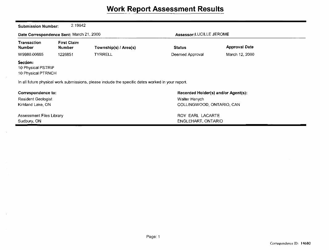
Work Report Assessment Results
Submission Number: 2.19942
Date Correspondence Sent: March 21, 2000^^^^^^^^^^^^^^^^Assessor:LUCILLE JEROME^^^^^^
Transaction First ClaimNumber Number Township(s) l Area(s) Status Approval Date
W9980.00665 1226851 TYRRELL Deemed Approval March 12,2000
Section:10 Physical PSTRIP 10 Physical PTRNCH
In all future physical work submissions, please include the specific dates worked in your report.
Correspondence to: Recorded Holder(s) and/or Agent(s):Resident Geologist Walter HanychKirkland Lake, ON COLLINGWOOD, ONTARIO, CAN
Assessment Files Library ROY EARL LACARTE Sudbury, ON ENGLEHART, ONTARIO
Page: 1Correspondence ID: 14680
KNIGHT TOWNSHIP , '
l Oi--p l
ur~' I * l -IQ V^, 119091J J 11*2419 |119M14 1^
ctr-j__\ - j___T-L——-jS3r NV"—— uU l -; 'T 1146421LIT Q l 11462*4 * . ^
r-4———E-l 11310*3 l fj.———— ————^
1219995 1221T8211^ 1221*50 121T558
^ li'-* i ^ j- 3*..
1219419
v——, 1219427 l(1220361 '^^————————4"" l ' . J
-J——-l"; — \™ 1 \I~~T' 4—frr~- H---rT-i V ' :|F -co l - , -——l— i
Road; highway, county, township access . . - - --.trail, bush
Shoreline (original)...............
Transmission line
Wooded area ..... ..............
A
DISPOSITION OF CROWN LANDSPatent
Surface i Mining RlQhta....... .. .... ............ ..... . QSurface Rights Only - - ,. . .. .. .. . .... . . Jk
Mining Rights Only .........................................e^
LaaseSurface K Mining Rights-...................... . .......... ^Surface Rights Only. .................,................ . gMining Rights Only .......... ....... ... . g
Reservation ... -........,.........,,,... ..,.......,.,......., /S^i\ i
Sand i Gravel -.............. - - - -............................. ^\
LAND USE PERMIT A
THE INFORMATION THAT APPEARS ON THIS MAP HAS BEEN COMPILED FROM VARIOUS SOURCES, AND ACCURACY IS NOT GUARANTEED. THOSE WISHING TO STAKE MINING CLAIMS SHOULD CONSULT WITH THE MINING RECORDER MINISTRY OF NORTHERN DEVELOPMENT AND MINES. FOR ADDITIONAL INFORMATION OH THE STATUS OF THE LANDS SHOWN HEREON

![FAMILY HISTORY SOCIETY · 2/2/2015 · 30 Tyrrell Family History Society Management Committee 2015 Chairman: Mike Tyrrell [828] chairman@tyrrell-fhs.org 32 Wren Crescent, Addlestone,](https://static.documents.pub/doc/80x56/606bbf549248a35c2265948f/family-history-society-222015-30-tyrrell-family-history-society-management.jpg)


