Geologic Map of the Stillwater Complex, Montana: A Digital Database Geology compiled by Norman J Page and Warren J. Nokleberg Digital database by Robert J. Miller Miscellaneous Investigations Series Map I-797 Digital database, version 1.0 2002 (map originally published in 1974) Database approved for publication March 8, 2002 Any use of trade, product, or firm names is for descriptive purposes only and does not imply endorsement by the U.S. Government. U.S. DEPARTMENT OF THE INTERIOR U.S. GEOLOGICAL SURVEY
Transcript
Geologic Map of the Stillwater Complex, Montana: A Digital Database Geology compiled by Norman J Page and Warren J. Nokleberg Digital database by Robert J. Miller
Miscellaneous Investigations Series Map I-797 Digital database, version 1.0 2002 (map originally published in 1974) Database approved for publication March 8, 2002 Any use of trade, product, or firm names is for descriptive purposes only and does not imply endorsement by the U.S. Government. U.S. DEPARTMENT OF THE INTERIOR U.S. GEOLOGICAL SURVEY
DESCRIPTION OF MAP UNITS.................................................................................................................................. 3
DATA SOURCES, PROCESSING, AND ACCURACY..........................................................................................10
GIS DOCUMENTATION..............................................................................................................................................11 LINEAR FEATURES.....................................................................................................................................................11 AREAL FEATURES.....................................................................................................................................................15 POINT FEATURES.......................................................................................................................................................17 SOURCE ATTRIBUTES...............................................................................................................................................18
OBTAINING DIGITAL DATA....................................................................................................................................18
OBTAINING PAPER MAPS .......................................................................................................................................19
REFERENCES CITED ON FIGURE 1.........................................................................................................................19
APPENDIX A – LIST OF FILES IN THE STILLWATER COMPLEX GIS.........................................................21
APPENDIX B – METADATA FILE (I797.MET) FOR THE STILLWATER COMPLEX GIS ..........................22
List of Figures
Figure 1. Index map showing the geographic extent of the spatial digital database _________4 Figure 2. Simplified geologic map of the Stillwater Complex _________________________5 Figure 3. Correlation of map units for the geologic map of the Stillwater Complex _________6 Figure 4. Relationships between feature attribute tables and look-up tables._____________12
3
Introduction This report publishes a geologic map database containing geology (lines and polygons) as
well as structural point data from the Geologic map of the Stillwater Complex (Page and Nokleberg, 1974). The four geology plates from the original publication were converted to a digital format by Optronics Specialty Co., Inc. in 2000. The four component maps were combined into single theme layers and a data model was populated with information from the correlation and description of map units of the original report.
This digital spatial database is one of many being created by the U.S. Geological Survey as an ongoing effort to provide geologic information for use in spatial analysis in a geographic information system (GIS). This database can be queried in many ways to produce a variety of geologic maps. A raster image of the original publication basemap is included. This database is not meant to be used or displayed at any scale larger than 1:12000 (for example, 1:2000).
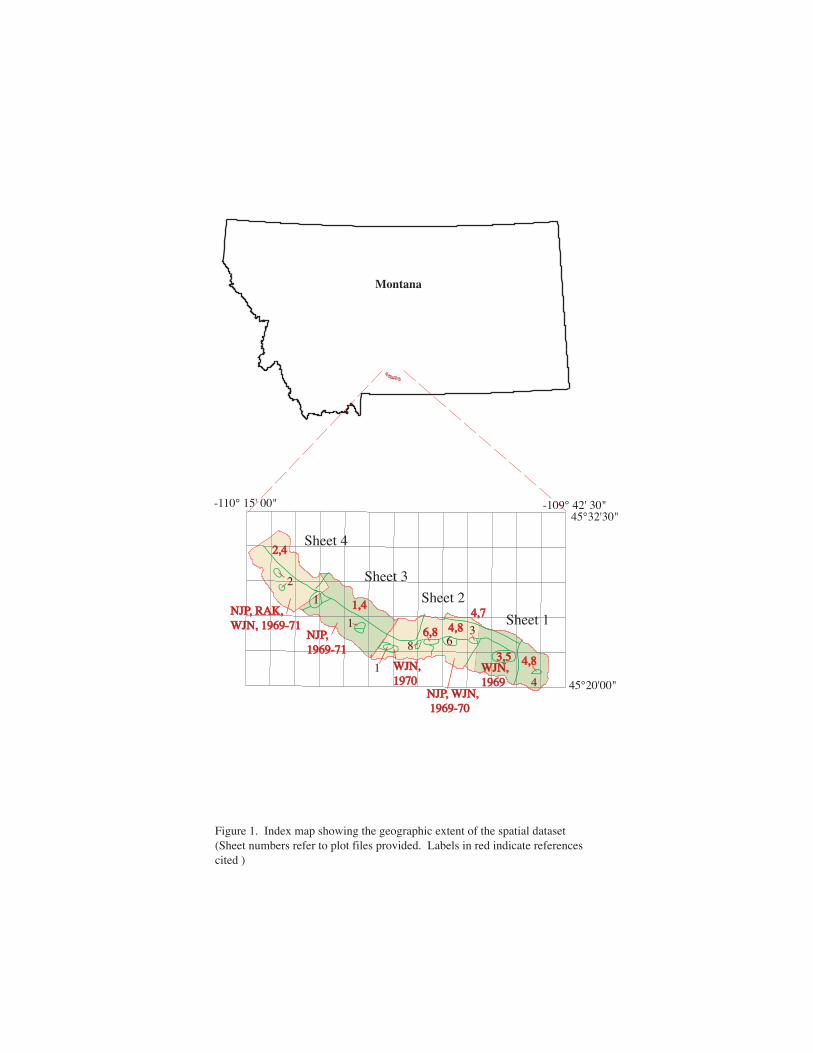
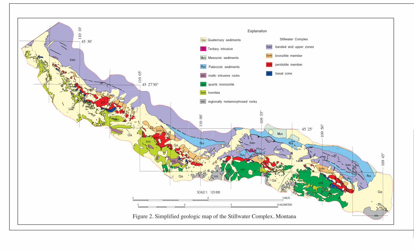
The map area is located in southern Montana (fig. 1). This report describes the map units (from Page and Nokleberg, 1974), the methods used to convert the geologic map data into a digital format, the ArcInfo GIS file structures and relationships, and explains how to download the digital files from the U.S. Geological Survey public access World Wide Web site on the Internet. A generalized version of the map is included (fig 2), along with the correlation of map units (fig. 3).
Manuscript and digital data review by Barry Moring is greatly appreciated.
Description of Map Units Page and Nokleberg’s (1974) descriptions of map units are included below as a courtesy to
the reader. Qal Alluvium—Unconsolidated to semiconsolidated interbedded clay, silt, sand, and gravel
of stream channel, floodplain, and terrace deposits Qt Talus deposits—Accumulations of angular to subangular pebble-, cobble-, and boulder-
sized fragments derived from nearby bedrock outcrops Qc Colluvium—Unconsolidated slope-wash deposits of mixed silt, sand, pebbles, and
cobbles. Includes soils and unconsolidated materials of undetermined origin Ql Landslide deposits—Unstratified heterogeneous mixtures of soil, glacial debris, and
angular rock fragments Qgf Glacial fan deposits—Unconsolidated sand, gravel, pebbles, cobbles, and boulders
forming fan-shaped areas at mouths of tributaries to major streams Qg Glacial deposits—Unstratified and stratified, semiconsolidated, poorly sorted, glacially
derived debris consisting of silt, sand, pebbles, cobbles, and boulders of igneous and metamorphic rocks; locally indurated with iron-oxide cement. In Stillwater River Valley includes lake sediments
Sheet 4
Sheet 3
Sheet 2
Sheet 1
-109° 42' 30"-110° 15' 00"45°32'30"
45°20'00"
2
2,42,4
1,41,41
6,86,86
3,53,5 4,84,8
41
4,74,74,84,8
NJP, WJN,NJP, WJN, 1969-70 1969-70
WJN, WJN, 19691969
WJN,WJN,19701970
83
1NJP,NJP,1969-711969-71
NJP, RAK,NJP, RAK,WJN, 1969-71WJN, 1969-71
Figure 1. Index map showing the geographic extent of the spatial dataset(Sheet numbers refer to plot files provided. Labels in red indicate references cited )
Montana
5 0 5 MILES
SCALE 1: 125 000
5 0 5 10 KILOMETERS
Explanation
Figure 2. Simplified geologic map of the Stillwater Complex, Montana
45° 25'
45° 30'
110°
00'
110°
05'
109°
55''
109°
50''
110°
10'
109°
45''
45° 27'30"
} }
}
}
}}
}
}}}
}
}}
}
} }}
}} }}}}}St
illw
ater
Com
plex
Ultr
amaf
icZ
one
Peri
dotit
eM
embe
r
Bas
al Z
one
Bro
nziti
teM
embe
r
Ban
ded
and
Upp
er Z
ones
PRECAMBRIAN
CAMBRIAN
ORDOVICIAN
DEVONIAN
MISSISSIPPIAN
PENNSYLVANIAN
UpperDevonianUpperOrdovician
LowerTriassic
UpperJurassic
TRIASSIC
JURASSIC
LowerCretaceous
HoloceneandPleistocene
CRETACEOUS
TERTIARY
QUATERNARY
7
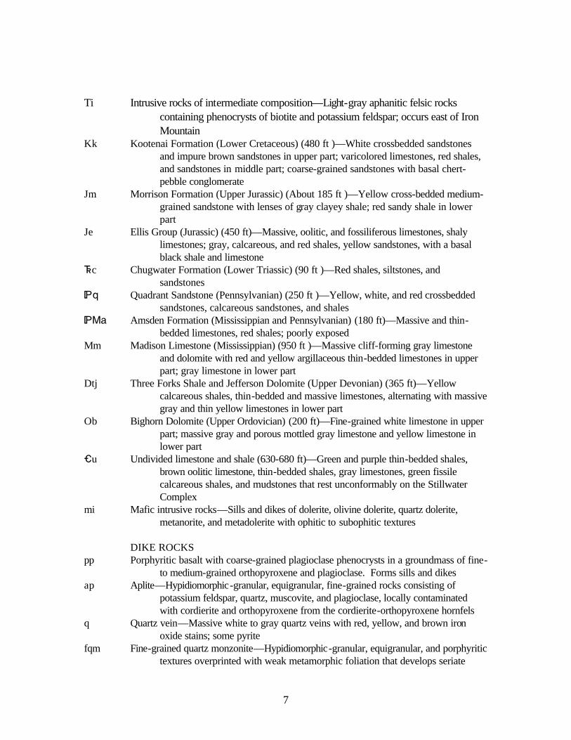
Ti Intrusive rocks of intermediate composition—Light-gray aphanitic felsic rocks
containing phenocrysts of biotite and potassium feldspar; occurs east of Iron Mountain
Kk Kootenai Formation (Lower Cretaceous) (480 ft )—White crossbedded sandstones and impure brown sandstones in upper part; varicolored limestones, red shales, and sandstones in middle part; coarse-grained sandstones with basal chert-pebble conglomerate
Jm Morrison Formation (Upper Jurassic) (About 185 ft )—Yellow cross-bedded medium-grained sandstone with lenses of gray clayey shale; red sandy shale in lower part
Je Ellis Group (Jurassic) (450 ft)—Massive, oolitic, and fossiliferous limestones, shaly limestones; gray, calcareous, and red shales, yellow sandstones, with a basal black shale and limestone
^c Chugwater Formation (Lower Triassic) (90 ft )—Red shales, siltstones, and sandstones
*q Quadrant Sandstone (Pennsylvanian) (250 ft )—Yellow, white, and red crossbedded sandstones, calcareous sandstones, and shales
*Ma Amsden Formation (Mississippian and Pennsylvanian) (180 ft)—Massive and thin-bedded limestones, red shales; poorly exposed
Mm Madison Limestone (Mississippian) (950 ft )—Massive cliff-forming gray limestone and dolomite with red and yellow argillaceous thin-bedded limestones in upper part; gray limestone in lower part
Dtj Three Forks Shale and Jefferson Dolomite (Upper Devonian) (365 ft)—Yellow calcareous shales, thin-bedded and massive limestones, alternating with massive gray and thin yellow limestones in lower part
Ob Bighorn Dolomite (Upper Ordovician) (200 ft)—Fine-grained white limestone in upper part; massive gray and porous mottled gray limestone and yellow limestone in lower part
_u Undivided limestone and shale (630-680 ft)—Green and purple thin-bedded shales, brown oolitic limestone, thin-bedded shales, gray limestones, green fissile calcareous shales, and mudstones that rest unconformably on the Stillwater Complex
mi Mafic intrusive rocks—Sills and dikes of dolerite, olivine dolerite, quartz dolerite, metanorite, and metadolerite with ophitic to subophitic textures
DIKE ROCKS pp Porphyritic basalt with coarse-grained plagioclase phenocrysts in a groundmass of fine-
to medium-grained orthopyroxene and plagioclase. Forms sills and dikes ap Aplite—Hypidiomorphic-granular, equigranular, fine-grained rocks consisting of
potassium feldspar, quartz, muscovite, and plagioclase, locally contaminated with cordierite and orthopyroxene from the cordierite-orthopyroxene hornfels
q Quartz vein—Massive white to gray quartz veins with red, yellow, and brown iron oxide stains; some pyrite
fqm Fine-grained quartz monzonite—Hypidiomorphic-granular, equigranular, and porphyritic textures overprinted with weak metamorphic foliation that develops seriate
8
grain boundaries; grain size less than 1 mm; modal composition: 29-34 percent quartz, 30-40 percent potassium feldspar, 22-35 percent plagioclase (Ab68-95), and 7-10 percent biotite
hd Hornblende quartz diorite—Hypidiomorphic-granular, medium-grained (1-5 mm), with average mode of 13 percent quartz, 52 percent plagioclase, 5 percent biotite, 25 percent hornblende, 3 percent epidote, and 3 percent chlorite; commonly highly altered
qm Coarse-grained quartz monzonite—Termed the Mouat quartzmonzonite pluton by Butler (1966, p. 54); hypidiomorphic-granular, equigranular, and porphyritic textures with weak metamorphic foliation developing seriate grain boundaries; grain size <5 mm; plagioclase and microcline phenocrysts, undulant quartz clots; modal composition: 27-31 percent quartz, 22-29 percent potassium feldspar, 34-39 percent plagioclase (Ab70-75), and 3-7 percent biotite. Along south ridge of Nye Creek contains 1.3- to 30.5-cm inclusions of hornfels and Basal zone rocks. Age, 2,700 to 2,750 m.y. based on U-Pb analyses of zircons by Nunes and Tilton (1971)
STILLWATER COMPLEX ban Banded and upper zones (about 14,100 ft maximum)—Cumulates of gabbroic
composition—principally interlayered orthopyroxene-plagioclase cumulates (norites and gabbros), orthopyroxene-clinopyroxene-plagioclase cumulates (gabbros), plagioclase cumulates (anorthosites), and olivine-plagioclase cumulates (troctolites); contains mineral-graded layers
Ultramafic zone ubc Bronzitite member (3,500 ft maximum, averages about 1,200 ft)—Upper bronzite
cumulates—cumulate rocks with bronzite and post-cumulus plagioclase and augite (bronzitite and norite); varies in grain size from fine to coarse
Peridotite member (about 3,500 ft average)—Consists of cumulate rocks that form cyclic units of oc, bc, and obc. Cycles without obc, bc, or both, are termed beheaded
bc Bronzite cumulates—Cumulate rocks with cumulus bronzite and post-cumulus plagioclase and augite (bronzitite and norite); forms upper part of normal cyclic unit. Average modal composition: 83 percent bronzite, 12 percent plagioclase, 4 percent augite, 0.3 percent chromite, biotite, and quartz
obc Olivine-bronzite cumulates—Cumulate rocks with cumulus olivine and bronzite in varying proportions and with postcumulus plagioclase and augite (granular harzburgites and olivine norites); contains mineral-graded layering; forms middle part of a normal cyclic unit. Modal composition: 1-70 percent olivine, 1-83 percent bronzite, 9 percent plagioclase, and 3 percent chromite
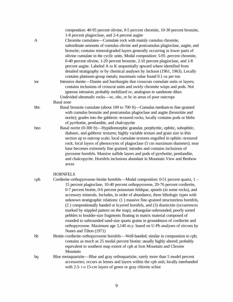
oc Olivine cumulates—Cumulate rock with cumulus olivine and post-cumulus plagioclase, augite, and bronzite; bronzite forms oikocrysts (dunite, poikilitic harzburgite, and olivine norite); forms lower part of a normal cyclic unit. Modal
A Chromite cumulates—Cumulate rock with mainly cumulus chromite, subordinate amounts of cumulus olivine and postcumulus plagioclase, augite, and bronzite; contains mineral-graded layers generally occurring in lower parts of olivine cumulate in the cyclic units. Modal composition: 5-95 .percent chromite, 0-40 percent olivine, 1-20 percent bronzite, 2-10 percent plagioclase, and 1-8 percent augite. Labeled A to K sequentially upward where identified from detailed stratigraphy or by chemical analyses by Jackson (1961, 1963). Locally contains platinum-group metals; maximum value found 0.1 oz per ton
ioc Intrusive dunite—Dunite and harzburgite that crosscuts cumulate units or layers; contains inclusions of crosscut units and swirly chromite wisps and pods. Not igneous intrusion; probably mobilized oc, analogous to sandstone dikes
Undivided ultramafic rocks—oc, obc, or bc in areas of poor outcrops Basal zone bbc Basal bronzite cumulate (about 100 to 700 ft)—Cumulus medium-to fine-grained
with cumulus bronzite and postcumulus plagioclase and augite (bronzitite and norite); grades into the gabbroic -textured rocks; locally contains pods or blebs of pyrrhotite, pentlandite, and chalcopyrite
bno Basal norite (0-300 ft)—Hypidiomorphic granular, porphyritic, ophitic, subophitic, diabasic, and gabbroic textures; highly variable texture and grain size in thin section up to outcrop scale; local cumulate textures engulfed in ophitic -textured rock; local layers of phenocrysts of plagioclase (5 cm maximum diameter); near base becomes extremely fine grained; intrudes and contains inclusions of pyroxene hornfels. Massive sulfide layers and pods of pyrrhotite, pentlandite, and chalcopyrite. Hornfels inclusions abundant in Mountain View and Benbow areas
15 percent plagioclase, 10-40 percent orthopyroxene, 20-76 percent cordierite, 0-7 percent biotite, 0-6 percent potassium feldspar, spinels (in some rocks), and accessory minerals. Includes, in order of abundance, three lithologic types with unknown stratigraphic relations: (1 ) massive fine-grained structureless hornfels, (2 ) compositionally banded or layered hornfels, and (3) diamictite (occurrences marked by stippled pattern on the map), subangular-subrounded, poorly sorted pebbles to boulder-size fragments floating in matrix material composed of rounded to subrounded sand-size quartz grains in groundmass of cordierite and orthopyroxene. Maximum age 3,140 m.y. based on U-Pb analyses of zircons by Nunes and Tilton (1971)
bh Biotite-cordierite-orthopyroxene hornfels—Well-banded; similar in composition to cph; contains as much as 25 modal percent biotite; usually highly altered; probably equivalent to southern map extent of cph at Iron Mountain and Chrome Mountain
bq Blue metaquartzite—Blue and gray orthoquartzite, rarely more than 5 model percent accessories; occurs as lenses and layers within the cph unit; locally interbanded with 2.5- t o 15-cm layers of green or gray chlorite schist
10
if Iron-formation—Interbanded layers of rocks rich in quartz, magnetite, orthopyroxene, fayalite, and combinations of these minerals; also present grunerite, albite, and a pink garnet; unit occurs as lenses and beds within the cph unit, usually associated with adjacent layers of bq
cah Anthophyllite-biotite-cordierite hornfels—Hornfelsic texture; locally, weakly developed lepidoblasitc texture in rocks containing anthophyllite in sheaflike bundles, cordierite porphyroblasts (to 2 mm in diameter), and, locally, garnet porphyroblasts in groundmass of quartz, biotite, and plagioclase (average grain size 0.2 mm). Includes area of relict-crossbedded rocks, cut-and-fill structures, ripple marks, well-layered hornfels (polygon i797-id number 395)
csh Chlorite schist—Sheared and chloritized rocks of diverse origin; no relict primary textures present; commonly occurs in fault zones
REGIONALLY METAMORPHOSED ROCKS ggn Granitic gneiss—Alternating bands of more felsic and mafic rocks, medium- to coarse-
bsh Biotite schist—Schistose texture, containing 20-50 percent quartz, 0-10 percent plagioclase, 25-48 percent biotite, 1-5 percent garnet, 0-10 percent staurolite, traces of cordierite; probably metasediments older than development of ggn
agn Amphibolitic gneiss—Foliated rock containg 19-70 percent hornblende, 10-40 percent plagioclase, 4-18 percent biotite, 9-30 percent quartz, garnet, and locally staurolite; probably old metasediments or metavolcanics older than development of ggn
bgn Biotite gneiss—Foliated quartzo-feldspathic rocks with greater than 15 percent modal biotite
pgn Plagioclase gneiss—Quartzo-feldspathic layered rock; similar to ggn but contains less than 5 percent modal potasssium feldspar; relative geologic age unknown
ggr Undivided granitic intrusive and metamorphic rocks—Occurs east of Fishtail Creek and consists of undivided mqm, ggn, and bgn
Data Sources, Processing, and Accuracy
Optronics Specialty Co., Inc. scanned and vectorized lines and labels from original paper printed maps of sheets 1 through 4 of Page and Nokleberg (1974). The preliminary digital files for each sheet were delivered to the U.S. Geological Survey in 2000. Helen Z. Kayser (Information Systems Support, Inc.) registered and transformed the ArcInfo datasets to the Montana state plane projection. Robert J. Miller merged the files for the sheets into two datasets, one containing geology lines and polygons, the other structural point data. The digital files were then augmented with an interim geologic map data model, further attributed and edited, and then plotted and compared to the original field geologic maps to check for digitizing and attributing errors. An image of the topographic basemap used for compilation and publication of Page and Nokleberg (1974) is also included in this report. This basemap was compiled prior to 1974 and does not correspond exactly to modern 1:24,000-scale topographic maps currently available. The transformation process for sheets 3 and 4 had a
11
RMS (root mean square) error of approximately 18 feet, sheets 1 and 2 had an error of approximately 8 feet. Hence the overall accuracy (with respect to the location of lines and points) of the spatial digital database (see fig. 2 for page-size version) is probably no better than +/-18 feet. The horizontal accuracy may locally appear worse if the dataset is used in conjunction with topographic data other than the base on which it was published. This digital database is not meant to be used or displayed at any scale larger than 1:12000.
All processing by the U.S. Geological Survey was done in ArcInfo versions 7 and 8 installed on Sun Ultra and Dell workstations.
GIS Documentation The digital geologic map of the Stillwater Complex consists of two ArcInfo datasets: 1)
i797.e00 which contains geologic units and lines and 2) i797p.e00 which contains structural point data. The geologic units and lines dataset (i797.e00) includes an arc attribute table, I797.AAT, that relates to the I797.CON, I797.ST3, I797.LGU, and I797.REF files; and a polygon attribute table, I797.PAT, that relates to the I797.RU and I797.REF files. The geologic map symbols dataset (i797p.e00) consists of a point attribute table, I797P.PAT, that relates to the I797P.SYM and I797P.REF look-up tables (see fig. 4). These data files are described below.
Linear Features Descriptions of the items identifying linear features such as contacts, boundaries (for
example, lines of latitude and longitude, state boundaries) and structures in the arc (or line) attribute table, I797.AAT, are as follows: I797.AAT ITEM NAME
ITEM TYPE
ITEM LENGTH
ATTRIBUTE DESCRIPTION
linecode integer 3 Numeric code used to identify type of linear feature. Linecodes < 100 are used for contacts and boundaries which are described in the I797.CON look-up table. Linecodes > 100 and < 600 represent structural features which are described in the I797.ST3 look-up table. Linecodes > 800 represent linear geologic units (units too small to be portrayed as polygons at a scale of 1:12,000) which are described in the I797.LGU look-up table.
name character 30 Name given to structural feature. source integer 4 Numeric code used to identify the data source for the linear
feature. Complete references for the sources are listed in the I797.REF look-up table.
Figure 4: Relationships between feature attribute tables and look-up tables.
i797.lgulinecodesymboltypeaccuracycertaintydesc
13
Attribute descriptions for items in the contact (and boundary) lookup-table, I797.CON (for
use with the GEOL_DIA.LIN lineset), are as follows: I797.CON ITEM NAME
ITEM TYPE
ITEM LENGTH
ATTRIBUTE DESCRIPTION
linecode integer 3 Numeric code (a value < 100) used to identify type of contact or boundary. (This item also occurs in I797.AAT.)
symbol integer 3 Line symbol number used by ArcInfo to plot lines. Symbol numbers refer to the GEOL_DIA.LIN lineset (a set of right-reading decorated lines).
type character 10 Major type of line, e.g., contact, state boundaries, lines of latitude and longitude used for neatlines.
modifier character 20 Line type modifier, i.e., approximate, concealed, gradational. No entry implies ‘known.’
certainty character 15 Degree of certainty of contact or boundary, i.e., inferred, uncertain. No entry implies ‘certain.’
desc character 100 Written description or explanation of contact or boundary. Attribute descriptions for items in the structure look-up table, I797.ST3 (for use with the
GEOL_DIA.LIN lineset), are as follows: I797.ST3 ITEM NAME
ITEM TYPE
ITEM LENGTH
ATTRIBUTE DESCRIPTION
linecode integer 3 Numeric code (a value > 100 and < 600) used to identify type of structural feature. (This item also occurs in I797.AAT.)
symbol integer 3 Line symbol number used by ArcInfo to plot arc (line). Symbol numbers refer to the GEOL_DIA.LIN lineset (a set of right-reading decorated lines).
type character 10 Major type of structure, i.e., fault, fracture, fold, other. horizontal character 20 Type of horizontal fault movement, for example, left-lateral,
right-lateral. No entry implies ‘unknown.’ vertical character 20 Type of vertical fault movement, for example, normal. No
entry implies ‘unknown.’ fold character 15 Type of fold, e.g., anticline, syncline. plunge character 15 Type of plunge on fold, i.e., horizontal, plunging, plunging in,
plunging out. accuracy character 15 Line type modifier indicating degree of accuracy, i.e.,
approximately located, concealed, gradational. No entry implies ‘known.’
certainty character 15 Degree of certainty of contact or boundary, i.e., inferred, uncertain. No entry implies ‘certain.’
desc character 100 Written description or explanation of structural feature.
14
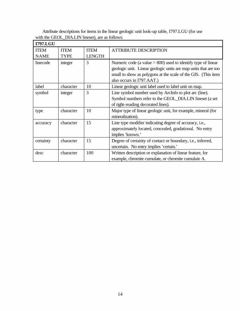
Attribute descriptions for items in the linear geologic unit look-up table, I797.LGU (for use with the GEOL_DIA.LIN lineset), are as follows: I797.LGU ITEM NAME
ITEM TYPE
ITEM LENGTH
ATTRIBUTE DESCRIPTION
linecode integer 3 Numeric code (a value > 800) used to identify type of linear geologic unit. Linear geologic units are map units that are too small to show as polygons at the scale of the GIS. (This item also occurs in I797.AAT.)
label character 10 Linear geologic unit label used to label unit on map. symbol integer 3 Line symbol number used by ArcInfo to plot arc (line).
Symbol numbers refer to the GEOL_DIA.LIN lineset (a set of right-reading decorated lines).
type character 10 Major type of linear geologic unit, for example, mineral (for mineralization).
accuracy character 15 Line type modifier indicating degree of accuracy, i.e., approximately located, concealed, gradational. No entry implies ‘known.’
certainty character 15 Degree of certainty of contact or boundary, i.e., inferred, uncertain. No entry implies ‘certain.’
desc character 100 Written description or explanation of linear feature, for example, chromite cumulate, or chromite cumulate A.
15
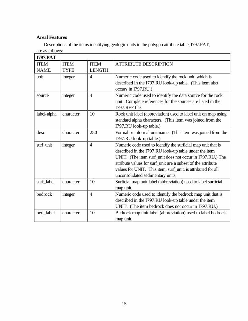
Areal Features Descriptions of the items identifying geologic units in the polygon attribute table, I797.PAT,
are as follows: I797.PAT ITEM NAME
ITEM TYPE
ITEM LENGTH
ATTRIBUTE DESCRIPTION
unit integer 4 Numeric code used to identify the rock unit, which is described in the I797.RU look-up table. (This item also occurs in I797.RU.)
source integer 4 Numeric code used to identify the data source for the rock unit. Complete references for the sources are listed in the I797.REF file.
label-alpha character 10 Rock unit label (abbreviation) used to label unit on map using standard alpha characters. (This item was joined from the I797.RU look-up table.)
desc character 250 Formal or informal unit name. (This item was joined from the I797.RU look-up table.)
surf_unit integer 4 Numeric code used to identify the surficial map unit that is described in the I797.RU look-up table under the item UNIT. (The item surf_unit does not occur in I797.RU.) The attribute values for surf_unit are a subset of the attribute values for UNIT. This item, surf_unit, is attributed for all unconsolidated sedimentary units.
surf_label character 10 Surficial map unit label (abbreviation) used to label surficial map unit.
bedrock integer 4 Numeric code used to identify the bedrock map unit that is described in the I797.RU look-up table under the item UNIT. (The item bedrock does not occur in I797.RU.)
bed_label character 10 Bedrock map unit label (abbreviation) used to label bedrock map unit.
16
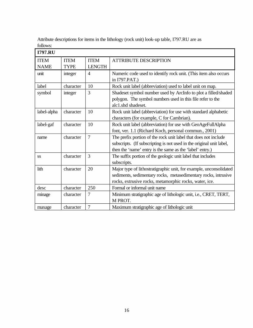
Attribute descriptions for items in the lithology (rock unit) look-up table, I797.RU are as follows: I797.RU
ITEM NAME
ITEM TYPE
ITEM LENGTH
ATTRIBUTE DESCRIPTION
unit integer 4 Numeric code used to identify rock unit. (This item also occurs in I797.PAT.)
label character 10 Rock unit label (abbreviation) used to label unit on map. symbol integer 3 Shadeset symbol number used by ArcInfo to plot a filled/shaded
polygon. The symbol numbers used in this file refer to the alc1.shd shadeset.
label-alpha character 10 Rock unit label (abbreviation) for use with standard alphabetic characters (for example, C for Cambrian).
label-gaf character 10 Rock unit label (abbreviation) for use with GeoAgeFullAlpha font, ver. 1.1 (Richard Koch, personal commun., 2001)
name character 7 The prefix portion of the rock unit label that does not include subscripts. (If subscripting is not used in the original unit label, then the ‘name’ entry is the same as the ‘label’ entry.)
ss character 3 The suffix portion of the geologic unit label that includes subscripts.
lith character 20 Major type of lithostratigraphic unit, for example, unconsolidated sediments, sedimentary rocks, metasedimentary rocks, intrusive rocks, extrusive rocks, metamorphic rocks, water, ice.
desc character 250 Formal or informal unit name minage character 7 Minimum stratigraphic age of lithologic unit, i.e., CRET, TERT,
M PROT. maxage character 7 Maximum stratigraphic age of lithologic unit
17
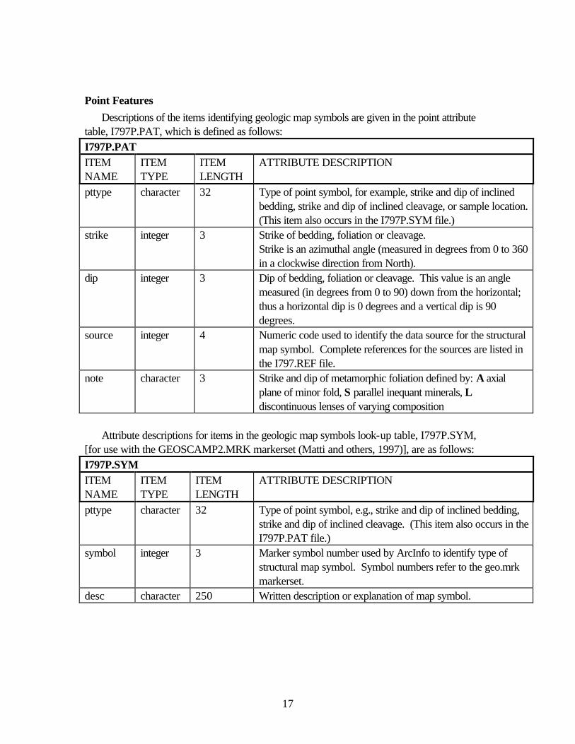
Point Features Descriptions of the items identifying geologic map symbols are given in the point attribute
table, I797P.PAT, which is defined as follows: I797P.PAT ITEM NAME
ITEM TYPE
ITEM LENGTH
ATTRIBUTE DESCRIPTION
pttype character 32 Type of point symbol, for example, strike and dip of inclined bedding, strike and dip of inclined cleavage, or sample location. (This item also occurs in the I797P.SYM file.)
strike integer 3 Strike of bedding, foliation or cleavage. Strike is an azimuthal angle (measured in degrees from 0 to 360 in a clockwise direction from North).
dip integer 3 Dip of bedding, foliation or cleavage. This value is an angle measured (in degrees from 0 to 90) down from the horizontal; thus a horizontal dip is 0 degrees and a vertical dip is 90 degrees.
source integer 4 Numeric code used to identify the data source for the structural map symbol. Complete references for the sources are listed in the I797.REF file.
note character 3 Strike and dip of metamorphic foliation defined by: A axial plane of minor fold, S parallel inequant minerals, L discontinuous lenses of varying composition
Attribute descriptions for items in the geologic map symbols look-up table, I797P.SYM,
[for use with the GEOSCAMP2.MRK markerset (Matti and others, 1997)], are as follows: I797P.SYM ITEM NAME
ITEM TYPE
ITEM LENGTH
ATTRIBUTE DESCRIPTION
pttype character 32 Type of point symbol, e.g., strike and dip of inclined bedding, strike and dip of inclined cleavage. (This item also occurs in the I797P.PAT file.)
symbol integer 3 Marker symbol number used by ArcInfo to identify type of structural map symbol. Symbol numbers refer to the geo.mrk markerset.
desc character 250 Written description or explanation of map symbol.
18
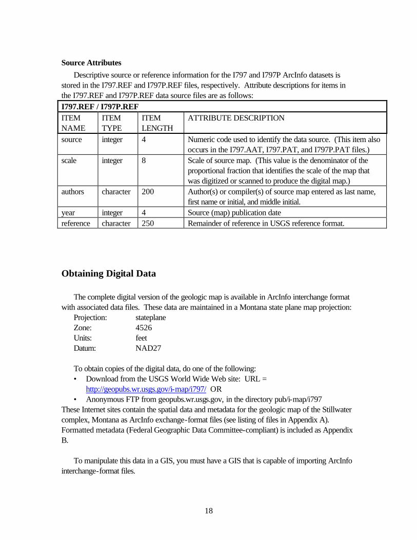
Source Attributes Descriptive source or reference information for the I797 and I797P ArcInfo datasets is
stored in the I797.REF and I797P.REF files, respectively. Attribute descriptions for items in the I797.REF and I797P.REF data source files are as follows: I797.REF / I797P.REF ITEM NAME
ITEM TYPE
ITEM LENGTH
ATTRIBUTE DESCRIPTION
source integer 4 Numeric code used to identify the data source. (This item also occurs in the I797.AAT, I797.PAT, and I797P.PAT files.)
scale integer 8 Scale of source map. (This value is the denominator of the proportional fraction that identifies the scale of the map that was digitized or scanned to produce the digital map.)
authors character 200 Author(s) or compiler(s) of source map entered as last name, first name or initial, and middle initial.
year integer 4 Source (map) publication date reference character 250 Remainder of reference in USGS reference format.
Obtaining Digital Data
The complete digital version of the geologic map is available in ArcInfo interchange format with associated data files. These data are maintained in a Montana state plane map projection:
To obtain copies of the digital data, do one of the following: • Download from the USGS World Wide Web site: URL =
http://geopubs.wr.usgs.gov/i-map/i797/ OR • Anonymous FTP from geopubs.wr.usgs.gov, in the directory pub/i-map/i797
These Internet sites contain the spatial data and metadata for the geologic map of the Stillwater complex, Montana as ArcInfo exchange-format files (see listing of files in Appendix A). Formatted metadata (Federal Geographic Data Committee-compliant) is included as Appendix B.
To manipulate this data in a GIS, you must have a GIS that is capable of importing ArcInfo
interchange-format files.
19
Obtaining Paper Maps Paper copies of the digital geologic map are not available from the U.S. Geological Survey.
However, with access to the Internet and access to a large-format color plotter that can interpret either postscript or PDF (portable document format) files, 1:12000-scale paper copies can be made. The database includes the entire area of the four map sheets in the original publication (Page and Nokleberg, 1974), however a single plot at 1:12000 would be too large for most plotters. Hence four plot files have been included which approximate the extent of the original map sheets. A fifth plot file contains the map explanation. 1. Download the digital version of the five map sheets, i797s1.pdf, i797s2.pdf, i797s3.pdf, i797s4.pdf, i797s5.pdf (or their postscript equivalents: i797s1.ps, i797s2.ps, i797s3. ps, i797s4. ps, i797s5.ps ) from the USGS public access World Wide Web site on the Internet using the URL = http://geopubs.wr.usgs.gov/i-map/i797/ or 2. Anonymous FTP the plot files listed above from geopubs.wr.usgs.gov, in the directory pub/i-map/i797 Sheets 1 through 4 are formatted to fit on a 36 inch by 48 inch plot . Sheet 5 is formatted for a 20 inch by 24 inch plot. Paper copies of the map can also be created by obtaining the digital file as described above and then creating a plot file in a GIS.
References Cited Butler, J.R., 1966, Geologic evolution of the Beartooth Mountains, Montana and Wyoming:
Geol. Soc. America Bull., v. 77, no. 1, p. 45-64. Jackson, E.D., 1963, Stratigraphic and lateral variation of chromite composition in the Stillwater
Complex: Mineral. Soc. America Spec. Paper 1, p. 46-54. Matti, J.C., Miller, F.K., Powell, R.E., Kennedy, S.A., Bunyapanasarn, T.P., Koukladas, C.,
Hauser, R.M., and Cossette, P.M., 1997, Geologic-point attributes for digital geologic-map data bases produced by the Southern California Areal Mapping Project (SCAMP): U.S. Geological Survey Open-File Report 97-859, 7 p.
Nunes, P.D., and Tilton, G.R., 1971, Uranium-lead ages of minerals from the Stillwater igneous complex and associated rocks, Montana: Geol. Soc. America Bull., v. 82, no. 8, p . 2231-2250.
Page, N. J and Nokleberg, W.J., 1974, Geologic map of the Stillwater Complex, Montana: U.S. Geological Survey Miscellaneous Investigations Series Map I-797, 5 sheets, scale 1:12000.
References Cited on Figure 1 Number preceding references below refer to numbered areas on fig. 1:
20
1. Howland, A.L., 1955, Chromite deposits in the central part of the Stillwater Complex. Montana: U.S. Geol. Survey Bull. 1015-D, p. 99-121.
2. Howland, A.L., Garrels, R.M., and Jones, W.R., 1949, Chromite deposits of Boulder River area, Sweetgrass County, Montana: U.S. Geol. Survey Bull. 948-C, p. 63-82.
3. Jackson, E.D., Howland, A.L., Peoples, J.W., and Jones, W.R., 1954, Geologic maps and sections of the eastern part of the Stillwater Complex, in Stillwater County, Montana: U.S. Geol. Survey open-file report.
4. Jones, W.R., Peoples. J.W., and Howland, A.L., 1960, Igneous and tectonic structures of the Stillwater Complex, Montana: U.S. Geol. Survey Bull. 1071-H, p. 281-335.
5. Peoples, J.W., and Howland, A.L., 1940, Chromite deposits of the eastern part of the Stillwater Complex, Stillwater County, Montana: U.S. Geol. Survey Bull. 922-N, p. 371-416.
6. Peoples, J.W., Howland, A.L., Jones, W.R., and Flint, Delos, 1954, Geologic maps, sections, and map of underground workings of the Mountain View Lake area, Stillwater County, Montana: U.S. Geol. Survey open-file report.
7. Vhay, J.S., 1934, The geology of a part of the Beartooth Mountain Front near Nye, Montana: Princeton Univ.. Ph. D. thesis p. 1-122.
8. Jackson, E.D., 1961, Primary textures and mineral associations in the Ultramafic zone of the Stillwater Complex, Montana: U.S. Geol. Survey Prof. Paper 358, p. 106.
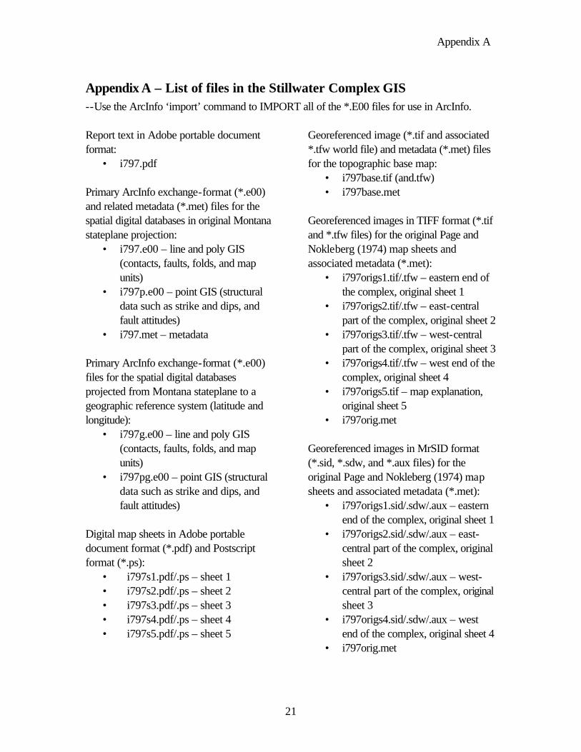
Appendix A
21
Appendix A – List of files in the Stillwater Complex GIS --Use the ArcInfo ‘import’ command to IMPORT all of the *.E00 files for use in ArcInfo. Report text in Adobe portable document format:
• i797.pdf Primary ArcInfo exchange-format (*.e00) and related metadata (*.met) files for the spatial digital databases in original Montana stateplane projection:
• i797.e00 – line and poly GIS (contacts, faults, folds, and map units)
• i797p.e00 – point GIS (structural data such as strike and dips, and fault attitudes)
• i797.met – metadata Primary ArcInfo exchange-format (*.e00) files for the spatial digital databases projected from Montana stateplane to a geographic reference system (latitude and longitude):
• i797g.e00 – line and poly GIS (contacts, faults, folds, and map units)
• i797pg.e00 – point GIS (structural data such as strike and dips, and fault attitudes)
Digital map sheets in Adobe portable document format (*.pdf) and Postscript format (*.ps):
Georeferenced image (*.tif and associated *.tfw world file) and metadata (*.met) files for the topographic base map:
• i797base.tif (and.tfw) • i797base.met
Georeferenced images in TIFF format (*.tif and *.tfw files) for the original Page and Nokleberg (1974) map sheets and associated metadata (*.met):
• i797origs1.tif/.tfw – eastern end of the complex, original sheet 1
• i797origs2.tif/.tfw – east-central part of the complex, original sheet 2
• i797origs3.tif/.tfw – west-central part of the complex, original sheet 3
• i797origs4.tif/.tfw – west end of the complex, original sheet 4
• i797origs5.tif – map explanation, original sheet 5
• i797orig.met Georeferenced images in MrSID format (*.sid, *.sdw, and *.aux files) for the original Page and Nokleberg (1974) map sheets and associated metadata (*.met):
• i797origs1.sid/.sdw/.aux – eastern end of the complex, original sheet 1
• i797origs2.sid/.sdw/.aux – east-central part of the complex, original sheet 2
• i797origs3.sid/.sdw/.aux – west-central part of the complex, original sheet 3
• i797origs4.sid/.sdw/.aux – west end of the complex, original sheet 4
• i797orig.met
Appendix B
22
Appendix B – Metadata file (i797.met) for the Stillwater Complex GIS Identification_Information: Citation: Citation_Information: Originator: Norman J Page Originator: Warren J. Nokleberg Originator: Robert J. Miller Publication_Date: 2002 Title: Geologic map of the Stillwater Complex, Montana: a digital database Edition: Version 1.0 Geospatial_Data_Presentation_Form: vector digital data Series_Information: Series_Name: U.S. Geological Survey Miscellaneous Investigations Series Issue_Identification: Map I-797 Publication_Information: Publication_Place: Menlo Park, CA Publisher: U. S. Geological Survey Online_Linkage: http://geopubs.wr.usgs.gov/i-map/i797/ Description: Abstract: This report provides a digital version of the Geologic map of the Stillwater Complex, Montana by Page and Nokleberg (1974). Paper copies of the four geologic map sheets from the original report were scanned and initially attributed by Optronics Specialty Co., Inc. (Northridge, CA) and remitted to the U.S. Geological Survey for further attribution and publication of the geospatial digital files. The resulting digital geologic dataset can be queried in a geographic information system (GIS) in many ways to produce a variety of geological maps. Purpose: This dataset was developed to provide a spatial database of the 1:12000-scale geologic map of the Stillwater Complex for use in future spatial analysis. These data can be printed in a variety of ways to display various geologic features or used for digital analysis and modeling. This database is not meant to be used or displayed at any scale larger than 1:12000. The digital geologic map files (i797s1.pdf/.ps, i797s2.pdf/.ps, i797s3.pdf/.ps, and i797s4.pdf/.ps) that are provided in the digital package are representations of the digital database. They are not designed to be cartographic products. Supplemental_Information: This GIS dataset consists of two ArcInfo datasets. The first is a line and polygon file (i797) containing geologic contacts and structures
Appendix B
23
(lines) and geologic map rock units (polygons). A second file contains structural point data (i797p). These coverages are also provided in the geographic coordinate system (i797g and i797pg). Because the topographic base map for the original publication (Page and Nokleberg, 1974) is no longer readily available, a georeferenced image of the original basemap is provided as i797base.tif/.tfw. In addition, georeferenced color images of the original map sheets have been provided as i797origs1.tif/.tfw, i797origs2.tif/.tfw, i797origs3.tif/.tfw, and i797origs4.tif/.tfw. Time_Period_of_Content: Time_Period_Information: Single_Date/Time: Calendar_Date: 2002 Currentness_Reference: publication date Status: Progress: Complete Maintenance_and_Update_Frequency: None planned Spatial_Domain: Bounding_Coordinates: West_Bounding_Coordinate: -110.247638 East_Bounding_Coordinate: -109.736573 North_Bounding_Coordinate: 45.520307 South_Bounding_Coordinate: 45.327177 Keywords: Theme: Theme_Keyword: geology Theme_Keyword: geologic map Theme_Keyword: structural geology Theme_Keyword: chromite Theme_Keyword: platinum Place: Place_Keyword: Beartooth Mountains Place_Keyword: Montana Place_Keyword: Stillwater County Place_Keyword: Sweetgrass County Stratum: Stratum_Keyword: Stillwater Complex Stratum_Keyword: Madison Limestone Stratum_Keyword: Morrison Formation Stratum_Keyword: Kootenai Formation Stratum_Keyword: Ellis Group Temporal:
Appendix B
24
Temporal_Keyword: Precambrian Temporal_Keyword: Mesozoic Temporal_Keyword: Cenozoic Access_Constraints: none Use_Constraints: This digital database is not meant to be used or displayed at any scale larger than 1:12,000 (e.g. 1:6,000). Any hardcopies utilizing these data sets shall clearly indicate their source. If the user has modified the data in any way they are obligated to describe the types of modifications they have performed on the hardcopy map. User specifically agrees not to misrepresent these data sets, nor to imply that changes they made were approved by the US Geological Survey Point_of_Contact: Contact_Information: Contact_Person_Primary: Contact_Person: Robert J. Miller Contact_Organization: U. S. Geological Survey Contact_Position: geologist Contact_Voice_Telephone: 650 329-5407 Contact_Electronic_Mail_Address: [email protected] Data_Set_Credit: Optronics Specialty Corp., Inc. (Northridge, CA) scanned the four geologic map sheets of Page and Nokleberg (1974) and provided minimally attributed ArcInfo interchange-format files to the U.S. Geological Survey. Helen Z. Kayser (contractor) registered and transformed to the datasets to the Montana state plane coordinate system. Robert J. Miller combined the 8 individual sheet files into the two-theme (geology and structural data) datasets, attached and attributed an interim geologic map data model; and visually compared the hard copy plots with the source documents. Native_Data_Set_Environment: Microsoft Windows 2000 Version 5.0 (Build 2195) Service Pack 2; ESRI ArcCatalog 8.1.0.642 Data_Quality_Information: Attribute_Accuracy: Attribute_Accuracy_Report: Attribute accuracy was verified by manual comparision of the source with hard copy printouts, plots, and on-screen evaluation. Logical_Consistency_Report: Polygon and chain-node topology present. Segments making up the outer and inner boundaries of a polygon tie end-to-end to completely enclose the area. Line segments are a set of sequentially numbered coordinate pairs. No duplicate features exist nor duplicate points in a data string. Intersecting lines are separated into individual line segments
Appendix B
25
at the point of intersection. All nodes are represented by a single coordinate pair, which indicates the beginning or end of a line segment. Completeness_Report: All geologic units were compiled from Page and Nokelberg (1974) at a scale of 1:12,000. Positional_Accuracy: Horizontal_Positional_Accuracy: Horizontal_Positional_Accuracy_Report: The horizontal position accuracy for the digital data is no better than 18 feet for the east half of map (sheet 1 and 2 of original publication) and 8 feet for western half (sheets 3 and 4 of the original) based on the digitizing root mean square (RMS) error. The geologic mapping was compiled on a topographic basemap map made in 1943. This basemap locally differs from modern 1:24,000-scale topographic maps of the area, and thus geologic linework may locally appear mislocated when viewed with other than the original publication's 1943 basemap. The individual scanned images of parts of the basemap typically had an RMS error of approximately 3 meters. However, where parts of the georeferenced scans overlap, local shifts of up 15 meters were noted. Lineage: Source_Information: Source_Citation: Citation_Information: Originator: N.J Page and W.N. Nokleberg Publication_Date: 1974 Title: Geologic map of the Stillwater Complex, Montana Geospatial_Data_Presentation_Form: map Series_Information: Series_Name: Miscellaneous Investigations Map Issue_Identification: Map I-797 Publication_Information: Publication_Place: Reston, Virginia Publisher: U. S. Geological Survey Source_Scale_Denominator: 12000 Type_of_Source_Media: paper Source_Time_Period_of_Content: Time_Period_Information: Single_Date/Time: Calendar_Date: 1974 Source_Currentness_Reference: Publication date
Appendix B
26
Source_Contribution: This map was the only map used to create the digital geologic map database. Process_Step: Process_Description: The published paper geologic map sheets were scanned by Optronics Speciality Corp., Inc. (Northridge, CA). Process_Date: 2000 Process_Step: Process_Description: The digital files were registered and transformed to state plane coordinate system by Helen Z. Kayser (contractor) at the USGS Spokane Field Office. Robert J. Miller combined the datasets and applied an iterim geologic map data model. The data were then checked for position and attribute accurracy by comparing plots of the digital data to the source maps. Process_Date: 2001 Process_Step: Process_Description: Low resolution scans (100 dpi) of portions of the basemap were georeferenced and converted to Arc/Info grids. The grids were clipped and merged into a single file then saved in a TIFF format. Process_Date: 2002 Spatial_Data_Organization_Information: Direct_Spatial_Reference_Method: Vector Point_and_Vector_Object_Information: SDTS_Terms_Description: SDTS_Point_and_Vector_Object_Type: Complete chain Point_and_Vector_Object_Count: 11679 SDTS_Terms_Description: SDTS_Point_and_Vector_Object_Type: Label point Point_and_Vector_Object_Count: 3911 SDTS_Terms_Description: SDTS_Point_and_Vector_Object_Type: GT-polygon composed of chains Point_and_Vector_Object_Count: 3911 SDTS_Terms_Description: SDTS_Point_and_Vector_Object_Type: Point Point_and_Vector_Object_Count: 114 Spatial_Reference_Information: Horizontal_Coordinate_System_Definition: Planar: Grid_Coordinate_System: Grid_Coordinate_System_Name: State Plane Coordinate System 1927 State_Plane_Coordinate_System:
Appendix B
27
SPCS_Zone_Identifier: 2503 Lambert_Conformal_Conic: Standard_Parallel: 44.866667 Standard_Parallel: 46.400000 Longitude_of_Central_Meridian: -109.500000 Latitude_of_Projection_Origin: 44.000000 False_Easting: 2000000.000000 False_Northing: 0.000000 Planar_Coordinate_Information: Planar_Coordinate_Encoding_Method: coordinate pair Coordinate_Representation: Abscissa_Resolution: 0.001195 Ordinate_Resolution: 0.001195 Planar_Distance_Units: survey feet Geodetic_Model: Horizontal_Datum_Name: North American Datum of 1927 Ellipsoid_Name: Clarke 1866 Semi-major_Axis: 6378206.400000 Denominator_of_Flattening_Ratio: 294.978698 Entity_and_Attribute_Information: Overview_Description: Entity_and_Attribute_Overview: The i797 dataset includes a geologic linework arc attribute table, i797.aat, that relates to the i797.con (contact look-up table), i797.st3 (structure look-up table),i797.lgu (linear geologic unit look-up table), and i797.ref (source reference look-up table) files; and a rock unit polygon attribute table, i797.pat, that relates to the i797.ru (rock unit look-up table) and i797.ref (source reference look-up table) files. The i797p dataset includes a structural point data attribute table, i797p.pat, that relates to the i797p.sym (symbol look-up table) and i797p.ref (source reference look-up table) files. Entity_and_Attribute_Detail_Citation: A detailed description of the items in the the Stillwater Complex database are given in the report text provided in Adobe Acrobat PDF format on the World Wide Web at http://geopubs.wr.usgs.gov/i-map/i797/i797.pdf Distribution_Information: Distributor: Contact_Information: Contact_Organization_Primary: Contact_Organization: U.S. Geological Survey
Appendix B
28
Contact_Instructions: This report is only available in electronic format at URL = http://geopubs.wr.usgs.gov/i-map/i797 or via anonymous FTP from geopubs.wr.usgs.gov, in the directory pub/i-map/i797. Distribution_Liability: The U.S. Geological Survey (USGS) provides these geographic data "as is". The USGS makes no guarantee or warranty concerning the accuracy of information contained in the geographic data. The USGS further makes no warranties, either expressed or implied as to any other matter whatsoever, including, without limitation, the condition of the product, or its fitness for any particular purpose. The burden for determining fitness for use lies entirely with the user. Although these data have been processed successfully on computers at the USGS, no warranty, expressed or implied, is made by the USGS regarding the use of these data on any other system, nor does the fact of distribution constitute or imply any such warranty. In no event shall the USGS have any liability whatsoever for payment of any consequential, incidental, indirect, special, or tort damages of any kind, including, but not limited to, any loss of profits arising out of use of or reliance on the geographic data or arising out of the delivery, installation, operation, or support by USGS. This digital geologic map GIS of the Stillwater Complex, Montana, is not meant to be used or displayed at any scale larger than 1:12,000 (for example, 1:2,000). Standard_Order_Process: Digital_Form: Digital_Transfer_Information: Transfer_Size: 4.080 Metadata_Reference_Information: Metadata_Date: 20020510 Metadata_Contact: Contact_Information: Contact_Organization_Primary: Contact_Organization: U.S. Geological Survey Contact_Person: Robert J. Miller Contact_Position: geologist Contact_Address: Address_Type: mailing address Address: MS 901 Address: 345 Middlefield Rd City: Menlo Park
Appendix B
29
State_or_Province: CA Postal_Code: 94025 Country: USA Contact_Voice_Telephone: 650 329-5407 Metadata_Standard_Name: FGDC Content Standards for Digital Geospatial Metadata Metadata_Standard_Version: FGDC-STD-001-1998 Metadata_Time_Convention: local time Metadata_Access_Constraints: none Metadata_Use_Constraints: none Metadata_Extensions: Online_Linkage: http://www.esri.com/metadata/esriprof80.html Profile_Name: ESRI Metadata Profile