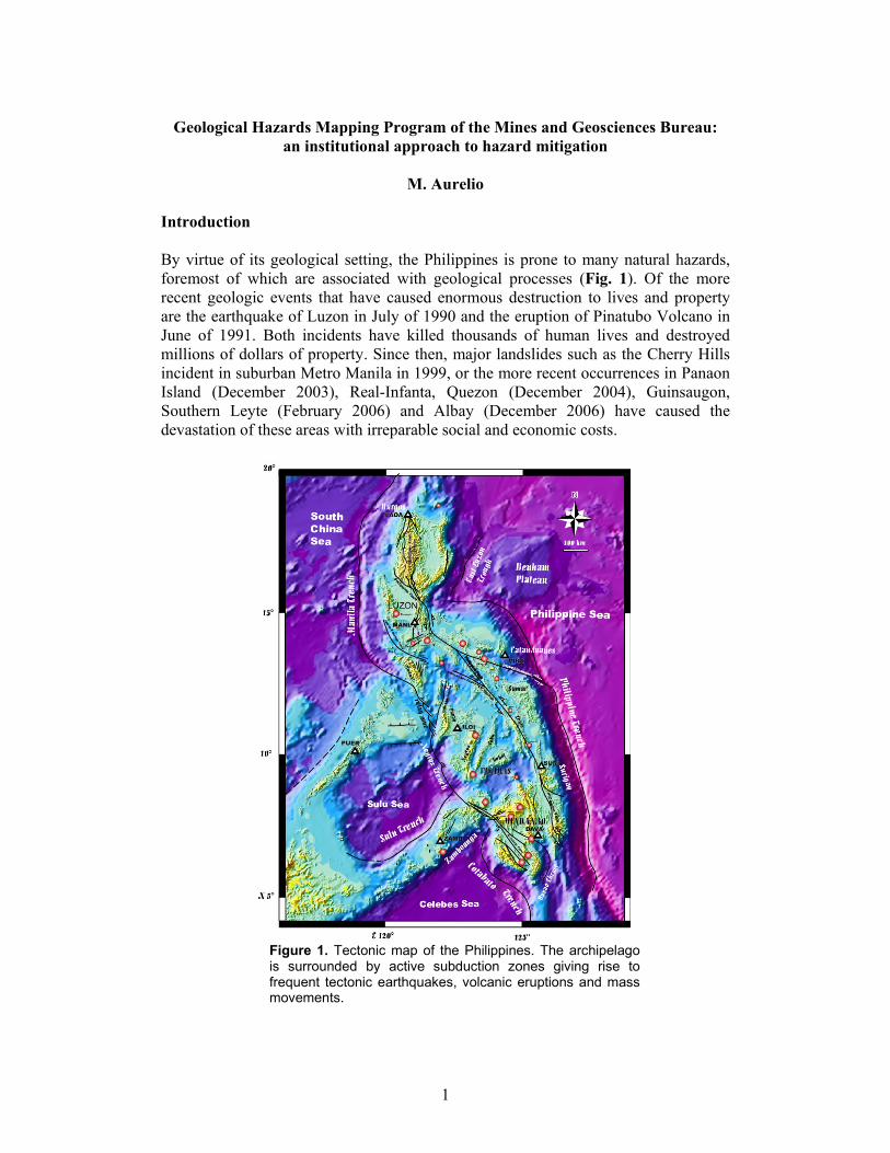
1 Geological Hazards Mapping Program of the Mines and Geosciences Bureau: an institutional approach to hazard mitigation M. Aurelio Introduction By virtue of its geological setting, the Philippines is prone to many natural hazards, foremost of which are associated with geological processes (Fig. 1). Of the more recent geologic events that have caused enormous destruction to lives and property are the earthquake of Luzon in July of 1990 and the eruption of Pinatubo Volcano in June of 1991. Both incidents have killed thousands of human lives and destroyed millions of dollars of property. Since then, major landslides such as the Cherry Hills incident in suburban Metro Manila in 1999, or the more recent occurrences in Panaon Island (December 2003), Real-Infanta, Quezon (December 2004), Guinsaugon, Southern Leyte (February 2006) and Albay (December 2006) have caused the devastation of these areas with irreparable social and economic costs. Figure 1. Tectonic map of the Philippines. The archipelago is surrounded by active subduction zones giving rise to frequent tectonic earthquakes, volcanic eruptions and mass movements.
Transcript
1
Geological Hazards Mapping Program of the Mines and Geosciences Bureau:
an institutional approach to hazard mitigation
M. Aurelio Introduction By virtue of its geological setting, the Philippines is prone to many natural hazards, foremost of which are associated with geological processes (Fig. 1). Of the more recent geologic events that have caused enormous destruction to lives and property are the earthquake of Luzon in July of 1990 and the eruption of Pinatubo Volcano in June of 1991. Both incidents have killed thousands of human lives and destroyed millions of dollars of property. Since then, major landslides such as the Cherry Hills incident in suburban Metro Manila in 1999, or the more recent occurrences in Panaon Island (December 2003), Real-Infanta, Quezon (December 2004), Guinsaugon, Southern Leyte (February 2006) and Albay (December 2006) have caused the devastation of these areas with irreparable social and economic costs.
Figure 1. Tectonic map of the Philippines. The archipelago is surrounded by active subduction zones giving rise to frequent tectonic earthquakes, volcanic eruptions and mass movements.
2
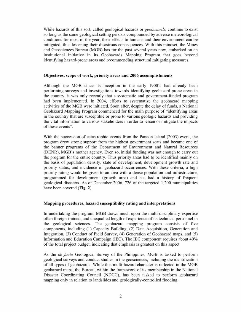
While hazards of this sort, called geological hazards or geohazards, continue to exist so long as the same geological setting persists compounded by adverse meteorological conditions for most of the year, their effects to humans and their environment can be mitigated, thus lessening their disastrous consequences. With this mindset, the Mines and Geosciences Bureau (MGB) has for the past several years now, embarked on an institutional initiative in its Geohazards Mapping Program that goes beyond identifying hazard-prone areas and recommending structural mitigating measures. Objectives, scope of work, priority areas and 2006 accomplishments Although the MGB since its inception in the early 1900’s had already been performing surveys and investigations towards identifying geohazard-prone areas in the country, it was only recently that a systematic and government-funded program had been implemented. In 2004, efforts to systematize the geohazard mapping activities of the MGB were initiated. Soon after, despite the delay of funds, a National Geohazard Mapping Program commenced for the main purpose of “identifying areas in the country that are susceptible or prone to various geologic hazards and providing the vital information to various stakeholders in order to lessen or mitigate the impacts of these events”. With the succession of catastrophic events from the Panaon Island (2003) event, the program drew strong support from the highest government seats and became one of the banner programs of the Department of Environment and Natural Resources (DENR), MGB’s mother agency. Even so, initial funding was not enough to carry out the program for the entire country. Thus priority areas had to be identified mainly on the basis of population density, state of development, development growth rate and priority status, and incidence of geohazard occurrences. With these criteria, a high priority rating would be given to an area with a dense population and infrastructure, programmed for development (growth area) and has had a history of frequent geological disasters. As of December 2006, 726 of the targeted 1,200 municipalities have been covered (Fig. 2). Mapping procedures, hazard susceptibility rating and interpretations In undertaking the program, MGB draws much upon the multi-disciplinary expertise often foreign-trained, and unequalled length of experience of its technical personnel in the geological sciences. The geohazard mapping program consists of five components, including (1) Capacity Building, (2) Data Acquisition, Generation and Integration, (3) Conduct of Field Survey, (4) Generation of Geohazard maps, and (5) Information and Education Campaign (IEC). The IEC component requires about 40% of the total project budget, indicating that emphasis is greatest on this aspect. As the de facto Geological Survey of the Philippines, MGB is tasked to perform geological surveys and conduct studies in the geosciences, including the identification of all types of geohazards. While this multi-hazard character is reflected in the MGB geohazard maps, the Bureau, within the framework of its membership in the National Disaster Coordinating Council (NDCC), has been tasked to perform geohazard mapping only in relation to landslides and geologically-controlled flooding.
3
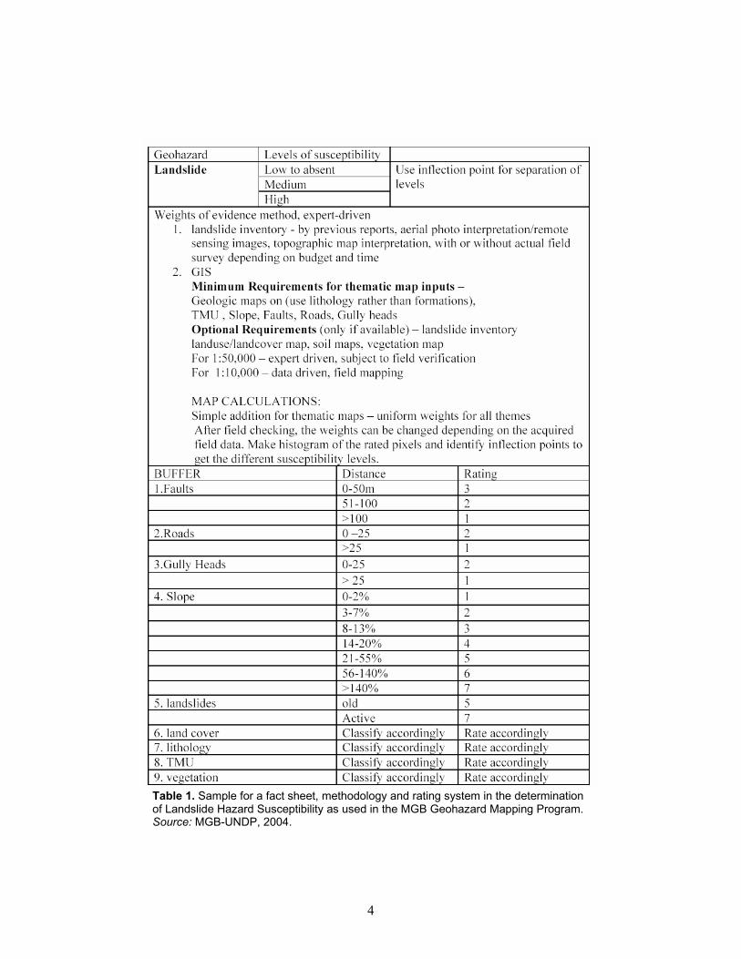
Geohazard maps are generated at 1:50,000 scale. From this scale, smaller areas are subsequently identified following a reiteration of the prioritization criteria, for mapping at a finer scale of 1:10,000. For landslides, aside from the classical criteria of slope angle, slope weight and material type, factors such as nearness to a fault, presence of roadcuts on hillsides, degree of gully erosion or vegetative cover, among others, are also taken into consideration. Table 1 shows how these and other factors are rated and used in the determination of landslide susceptibility. A similar procedure is adopted for each of the other hazards such as flooding, settlement, subsidence, erosion, siltation, salt water intrusion, and groundwater-, earthquake- and volcano-related hazards.
Figure 2. 2006 Update of accomplishments of the MGB Geohazard Mapping Program (as of December). See map for legend.
4
Table 1. Sample for a fact sheet, methodology and rating system in the determination of Landslide Hazard Susceptibility as used in the MGB Geohazard Mapping Program. Source: MGB-UNDP, 2004.
5
Maximizing effectivity through IEC, policy integration and legislation The MGB Geohazard Mapping Program was designed such that the products (geohazard maps with explanatory notes/brochures) are not only disseminated to stakeholders, but more importantly, that the information contained in these maps and their usefulness to practical problems are explained to them. In fact, this component takes about 40% of the total project budget, leaving the remaining 60% distributed over the four other components. Information and education campaign (IEC) activities are normally in the form of seminars and workshops organized by the MGB in coordination with local government units. Participation is not restricted to MGB and LGUs only, but also includes other government agencies involved in geohazard assessment (e.g. PAGASA, DPWH, BSWM), the local populace, non-governmental, civil society and environmental groups, among others. For the purpose of maximizing effectivity of the program, the MGB also is very actively participating in policy-making endeavours especially at the national level. For instance, the bureau, being a member of the NEDA-chaired National Land Use Committee (NLUC), is seriously pursuing its intent to integrate geohazard maps in the preparation of Comprehensive Land Use Plans (CLUPs) at all levels of local government (e.g. Aurelio, 2006). In addition, the MGB within its mother agency the DENR, implements institutional programs and issues directives consistent with the same pursuit (e.g. Aurelio, 2004). Most notable of these issuances are DENR Administrative Order No. 28, Series of 2000 and MGB Memorandum Circular No. 33, Series of 2000 and subsequent issuances. These initiatives require all development projects to undergo an Engineering Geological and Geohazard Assessment (EGGA), as an additional requirement in the application for an Environmental Compliance Certificate (ECC). Concluding Remarks While non-systematic predecessor geohazard programs of the MGB have been implemented as early as the constitution of the Bureau as the mandated agency to perform geological surveys and researches, the current Geohazard Mapping Program has yet to see a more-than-satisfactory attainment of the desired effects, especially with respect to hazard mitigation. One fundamental reason for this seemingly unsatisfactory result is financial, but a more important lacking ingredient appears to be a strong political backing from government authorities. More positively though, if the support provided by the national government, complemented by those from foreign-funding agencies, as experienced in the last couple of years, thanks in part to the disasters of Panaon (2003), Aurora-Quezon (2004) and Guinsaugon (2006), is sustained (better if increased!), a brighter light at the end of the tunnel is in sight.
6
References Aurelio, M.A., 2004. Engineering Geological and Geohazard Assessment (EGGA)
Aurelio, M.A., 2006. MGB’s Geohazard Mapping Program for Land Use and Physical
Planning. Proceedings: 36th Meeting of the National Land Use Committee, National Economic Development Authority, 15 March 2006. PowerPoint presentation.
DENR AO 2000-28. Implementing guidelines on Engineering Geological and
Geohazard Assessment (EGGA) as additional requirement for ECC applications covering subdivision, housing and other land development and infrastructure projects. Administrative Order No. 28, Series of 2000. Department of Environment and Natural Resources, Philippines. 14 March 2000.
MGB MC 2000-33. Guidelines and outline/checklist for the preparation of an
Engineering Geological and Geohazard Assessment Report (EGGAR) as per DENR AO 2000-28. Memorandum Circular No. 33, Series of 2000. Mines and Geosciences Bureau, Philippines, 24 March 2000.
MGB-UNDP, 2004. Manual for Standardization, Geohazard Mapping Program.
Mines and Geosciences Bureau project, funded by the United Nations Development Program, March 2004.