+ All Categories
Home > Documents > Geophysical prospecting for new cave passages: Fort Stanton Cave, New Mexico, USA

Geophysical prospecting for new cave passages: Fort Stanton Cave, New Mexico, USA

Date post: 23-Aug-2016
Category:
Upload: lewis
View: 212 times
Download: 0 times
Share this document with a friend
6
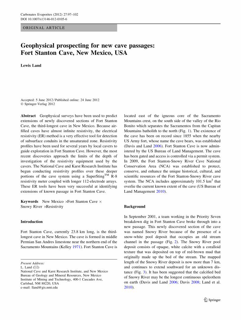
ORIGINAL ARTICLE Geophysical prospecting for new cave passages: Fort Stanton Cave, New Mexico, USA Lewis Land Accepted: 5 June 2012 / Published online: 24 June 2012 Ó Springer-Verlag 2012 Abstract Geophysical surveys have been used to predict extensions of newly discovered sections of Fort Stanton Cave, the third-longest cave in New Mexico. Because air- filled caves have almost infinite resistivity, the electrical resistivity (ER) method is a very effective tool for detection of subsurface conduits in the unsaturated zone. Resistivity profiles have been used for several years by local cavers to guide exploration in Fort Stanton Cave. However, the most recent discoveries approach the limits of the depth of investigation of the resistivity equipment used by the cavers. The National Cave and Karst Research Institute has begun conducting resistivity profiles over these deeper portions of the cave system using a SuperSting TM R-8 resistivity meter coupled with longer 112-electrode arrays. These ER tools have been very successful at identifying extensions of known passage in Fort Stanton Cave. Keywords New Mexico Á Fort Stanton Cave Á Snowy River Á Resistivity Introduction Fort Stanton Cave, currently 23.8 km long, is the third- longest cave in New Mexico. The cave is formed in middle Permian San Andres limestone near the northern end of the Sacramento Mountains (Kelley 1971). Fort Stanton Cave is located east of the igneous core of the Sacramento Mountains crest, on the south side of the valley of the Rio Bonito which separates the Sacramentos from the Capitan Mountains batholith to the north (Fig. 1). The existence of the cave has been on record since 1855 when the nearby US Army fort, whose name the cave bears, was established (Davis and Land 2006). Fort Stanton Cave is now admin- istered by the US Bureau of Land Management. The cave has been gated and access is controlled via a permit system. In 2009, the Fort Stanton-Snowy River Cave National Conservation Area (NCA) was established to protect, conserve, and enhance the unique historical, cultural, and scientific resources of the Fort Stanton-Snowy River cave system. The NCA includes approximately 101.5 km 2 that overlie the current known extent of the cave (US Bureau of Land Management 2010). Background In September 2001, a team working in the Priority Seven breakdown dig in Fort Stanton Cave broke through into a new passage. This newly discovered section of the cave was named Snowy River because of the presence of a snow-white pool deposit that occupies an old stream channel in the passage (Fig. 2). The Snowy River pool deposit consists of opaque, white calcite with a coralloid texture that was deposited on top of red-brown mud that originally made up the bed of the stream. The mapped length of the Snowy River deposit is now more than 7 km, and continues to extend southward for an unknown dis- tance (Fig. 3). It has been suggested that the calcified bed of Snowy River may be the longest continuous speleothem on earth (Davis and Land 2006; Davis 2008; Land et al. 2010). Present Address: L. Land (&) National Cave and Karst Research Institute, and New Mexico Bureau of Geology and Mineral Resources, New Mexico Institute of Mining and Technology, 400-1 Cascades Ave, Carlsbad, NM 88220, USA e-mail: [email protected] 123 Carbonates Evaporites (2012) 27:97–102 DOI 10.1007/s13146-012-0105-6
Transcript

ORIGINAL ARTICLE

Geophysical prospecting for new cave passages:Fort Stanton Cave, New Mexico, USA

Lewis Land

Accepted: 5 June 2012 / Published online: 24 June 2012

� Springer-Verlag 2012

Abstract Geophysical surveys have been used to predict

extensions of newly discovered sections of Fort Stanton

Cave, the third-longest cave in New Mexico. Because air-

filled caves have almost infinite resistivity, the electrical

resistivity (ER) method is a very effective tool for detection

of subsurface conduits in the unsaturated zone. Resistivity

profiles have been used for several years by local cavers to

guide exploration in Fort Stanton Cave. However, the most

recent discoveries approach the limits of the depth of

investigation of the resistivity equipment used by the

cavers. The National Cave and Karst Research Institute has

begun conducting resistivity profiles over these deeper

portions of the cave system using a SuperStingTM R-8

resistivity meter coupled with longer 112-electrode arrays.

These ER tools have been very successful at identifying

extensions of known passage in Fort Stanton Cave.

Keywords New Mexico � Fort Stanton Cave �Snowy River � Resistivity

Introduction

Fort Stanton Cave, currently 23.8 km long, is the third-

longest cave in New Mexico. The cave is formed in middle

Permian San Andres limestone near the northern end of the

Sacramento Mountains (Kelley 1971). Fort Stanton Cave is

located east of the igneous core of the Sacramento

Mountains crest, on the south side of the valley of the Rio

Bonito which separates the Sacramentos from the Capitan

Mountains batholith to the north (Fig. 1). The existence of

the cave has been on record since 1855 when the nearby

US Army fort, whose name the cave bears, was established

(Davis and Land 2006). Fort Stanton Cave is now admin-

istered by the US Bureau of Land Management. The cave

has been gated and access is controlled via a permit system.

In 2009, the Fort Stanton-Snowy River Cave National

Conservation Area (NCA) was established to protect,

conserve, and enhance the unique historical, cultural, and

scientific resources of the Fort Stanton-Snowy River cave

system. The NCA includes approximately 101.5 km2 that

overlie the current known extent of the cave (US Bureau of

Land Management 2010).

Background

In September 2001, a team working in the Priority Seven

breakdown dig in Fort Stanton Cave broke through into a

new passage. This newly discovered section of the cave

was named Snowy River because of the presence of a

snow-white pool deposit that occupies an old stream

channel in the passage (Fig. 2). The Snowy River pool

deposit consists of opaque, white calcite with a coralloid

texture that was deposited on top of red-brown mud that

originally made up the bed of the stream. The mapped

length of the Snowy River deposit is now more than 7 km,

and continues to extend southward for an unknown dis-

tance (Fig. 3). It has been suggested that the calcified bed

of Snowy River may be the longest continuous speleothem

on earth (Davis and Land 2006; Davis 2008; Land et al.

2010).

Present Address:L. Land (&)

National Cave and Karst Research Institute, and New Mexico

Bureau of Geology and Mineral Resources, New Mexico

Institute of Mining and Technology, 400-1 Cascades Ave,

Carlsbad, NM 88220, USA

e-mail: [email protected]

123

Carbonates Evaporites (2012) 27:97–102

DOI 10.1007/s13146-012-0105-6

During the initial scientific assessment survey in July

2003, a small fragment of the upper surface of the Snowy

River deposit was collected and was subsequently dated by

the University of New Mexico Radiogenic Isotope Lab

using Uranium-series method at 152 ± 61 years (Davis

and Land 2006). This young age indicates that part or all of

the Snowy River Formation was deposited in historic times

during periods when calcium carbonate-saturated water

was present in the stream channel. Subsequent expeditions

have collected cores from the Snowy River deposit.

Radiometric dates from the bases of these cores indicate

that Snowy River is only 800–1,000 years old (Land et al.

2010).

It is assumed that the Snowy River deposit formed by

CO2 degassing of calcite-saturated water that periodically

flows through the Snowy River passage—similar to tufa

and travertine deposits in surface streams and springs (as

seen in Andrews 2006, Fig. 5). However, unlike surface

tufa, the Snowy River deposit has been sheltered from

surface weathering processes and has a distinctively pris-

tine appearance (Fig. 2).

Hydrologic observations

Although the Snowy River passage was completely dry

when first discovered, flowing water approximately 30 cm

deep was present for a few months in 2007, 2008, and 2010

in the aftermath of heavy monsoonal rainfall and extreme

Fig. 1 Simplified geologic map

of northern Sacramento

Mountains, showing location of

Fort Stanton Cave (FSC).

Cp Capitan, Rd Ruidoso

Fig. 2 Photograph of Snowy River deposit. Note sharply-defined

upper waterline

98 Carbonates Evaporites (2012) 27:97–102

123

flooding events. Streamflow in the passage is from south to

north. The northeast end of the Snowy River North passage

appears to end at a terminal sump in a subterranean spring

pool known as Crystal Creek, although water flow is

assumed to continue northeast through flooded conduits. A

dye trace investigation conducted in 2008 indicates that

water flowing through Snowy River North discharges into

the Rio Bonito at Government Spring (Fig. 3), located

450 m northeast of the surveyed end of the passage. Flow

velocities between the Crystal Creek sump and Govern-

ment Spring are estimated at about 25 m/h, or 600 m/day,

consistent with conduit flow rates measured in other karstic

aquifers and cave systems in the southwest and worldwide

(Worthington 2007; Land and Burger 2008).

In August 2008, a data logger was deployed at Mud

Turtle Junction in the Snowy River passage. The data

logger made hourly recordings of water levels and water

temperature in the flooded Snowy River passage from

August 8, 2008, to April 28, 2009 (Fig. 4). The record

shows a gradual decline in water levels in the passage from

34 to 27 cm between August 8 and December 25, 2008.

Then, in the 1-week period between December 25 and

January 1, 2009, water levels declined to zero and

remained there for the duration of the period of record. In

Fig. 3 Line map of Fort

Stanton Cave. Surveyed length

as of October, 2009 = 23.8 km.

GS Government Spring

Carbonates Evaporites (2012) 27:97–102 99

123

April 2010, water again appeared in the Snowy River

passage, probably in response to record levels of snowfall

in the northern Sacramento Mountains the previous winter.

Data logger records indicate that water levels rose from

zero to about 30 cm in less than 1 h.

The origin of water flow in the Snowy River passage has

been the subject of considerable speculation since it was

first observed in 2007, in part because water flow in Snowy

River is not coincident with flooding in the main passage of

Fort Stanton Cave. Furthermore, the presence of water does

not appear to be an annual event, but is associated with

extreme summer precipitation events or very heavy winter

snowfall in the northern Sacramento Mountains. Two

potential end-member sources for the water include (1)

diffuse flow into the passage associated with a rising water

table and (2) a point source of recharge through a sinkhole

or losing stream. The sudden disappearance of water in the

Snowy River passage during the last week of 2008 is more

consistent with a point source model: It seems unlikely that

evaporation or the slow percolation of water into under-

lying sediment would occur so rapidly. Rather, the record

would suggest that the water supply had abruptly ceased.

Another possible source may be a subterranean pool far to

the south that periodically rises to a spill point and abruptly

introduces water into the Snowy River passage.

The broader implication of the point source hypothesis

is the existence of a second entrance into the Snowy River

section of Fort Stanton Cave, presumably somewhere far-

ther to the south. Whether this possible second entrance

would be enterable by humans can only be determined by

further exploration.

Methods

Electrical resistivity surveys

For several years, cavers with the Fort Stanton Cave Study

Project (FSCSP) have been using electrical resistivity (ER)

surveys to guide exploration in Fort Stanton Cave (McLean

and Luke 2006). However, the most recent discoveries in the

Snowy River South passage have approached the limits of the

depth of investigation of equipment used by the cavers.

Beginning in May 2010, National Cave and Karst Research

Institute (NCKRI) personnel, assisted by FSCSP volunteers,

began conducting ER surveys over projected extensions of the

Snowy River North and South passages using a SuperStingTM

R-8 resistivity meter with 56 and 112 electrode arrays.

The basic operating principal for resistivity surveys

involves generating a direct current, or an alternating cur-

rent of very low frequency, between two metal electrodes

implanted in the ground, while the ground voltage is

measured between two additional implanted electrodes.

Given the current flow and measured voltage drop between

two electrodes, the subsurface resistivity between the

electrodes can be determined and mapped. Resistivity

profiles detect vertical and lateral variations in resistivity in

the subsurface. The presence of water or electrically con-

ductive water-saturated soil or bedrock will strongly affect

the results of a resistivity survey. Since air has near-infinite

resistivity, in contrast with the more conductive sur-

rounding bedrock, the electrical resistivity method is well

suited for exploration for air-filled caves in the unsaturated

zone. Depth of investigation is directly related to length of

the array of electrodes—the longer the array, the greater

the penetration that can be obtained.

Resistivity profiles were terrain-corrected using elevation

data collected with a survey-grade GPS receiver. EarthIm-

ager-2DTM software was used to process the resistivity data,

using a smooth-model inversion method to provide an esti-

mate of subsurface resistivity distribution. Inverse model

output is presented as a profile, incorporating the measured

topography, similar to a geologic cross-section.

Results and discussion

Initial field trials in May were conducted over a projected

northeast extension of Snowy River North (Fig. 5). These

surveys used a 56-electrode array in dipole–dipole config-

uration with 3 m spacing between electrodes. Line SRN-2 is

located about 100 m northeast of the surveyed end of

Snowy River North and achieved a maximum depth of

investigation of 58 m (Fig. 6). Near the center of the profile

is a high-resistivity anomaly coincident with a northeast

projection of Snowy River North to Government Spring. It

Fig. 4 Data logger record showing water levels in Snowy River

passage at Mud Turtle Junction. The 3-day period of zero water level

in October 2008 occurred when the instrument was removed from the

channel for repairs

100 Carbonates Evaporites (2012) 27:97–102

123

is assumed that this zone of high apparent resistivity rep-

resents a northeast extension of the Snowy River North

passage. However, since the maximum apparent resistivity

on the profile is less than 1,000 Xm, it is unlikely that the

passage is air-filled. The high resistivity zone probably

reflects fresh water flow through flooded conduits that dis-

charge at Government Spring. This interpretation is sup-

ported by the fact that the elevation of Government Spring

(1,824 m)is a few meters higher than the top of the high-

resistivity anomaly on the SRN-2 profile.

NCKRI and FSCSP personnel conducted additional

resistivity surveys in July and September 2010 over a

projected southwest extension of Snowy River South

(Fig. 7). The full 112-electrode array was used in a pole-

dipole configuration at 6 m electrode spacing. A dipole–

dipole survey was also conducted along the SRS-1 line and

data from the two surveys were merged to improve reso-

lution. Maximum depth of investigation on these profiles is

approximately 245 m below ground level. At the time of

this writing, the Snowy River South passage is still

continuing in a southwest direction, although survey and

exploration have been temporarily halted out of concern for

the delicate nature of the Snowy River deposit in the

Eggshell Trail portion of the passage. Thus, resistivity

surveys are the only method available to evaluate the fur-

ther extent of Snowy River South.

Fig. 6 SRN-2ER profile over

Snowy River North. Location of

survey line shown in Fig. 5

Fig. 7 Locations of ER survey

lines over projected southwest

extension of Snowy River South

(dashed red line). Orange-redellipses show locations of

resistivity anomalies on the ER

profiles. Solid red line shows

location of the

southwesternmost surveyed

portion of Snowy River South

Fig. 5 Locations of electrical resistivity surveys over projected

northeast extension of Snowy River North passage

Carbonates Evaporites (2012) 27:97–102 101

123

The center point of line SRS-1 is located 246 m south-

west of the surveyed end of Snowy River South (Fig. 7). A

broad zone of high apparent resistivity occurs on the profile

at a depth of about 120 m (Fig. 8), approximately the same

as the projected depth of Snowy River South. Although the

maximum apparent resistivity is less than 1,100 Xm, it is

unlikely that the cave is water-filled at this location given

its proximity to surveyed non-flooded passage. The lower

than anticipated resistivity may be an artifact of the mod-

eling procedure. Nevertheless, it seems clear that the pas-

sage continues to the west-southwest and can be identified

using ER survey methods.

Line SRS-2 is located about 800 m beyond the surveyed

end of Snowy River South (Fig. 7). The SRS-2 profile

shows a well-defined zone of high resistivity about 170 m

below ground level with apparent resistivity values of

almost 100,000 Xm (Fig. 9). The data strongly suggest the

continued presence of air-filled passage almost a kilometer

southwest of the last in-cave survey and appear to indicate

that the Snowy River South passage may be turning to the

southwest beneath the Ruidoso airport.

Conclusions

Electrical resistivity surveys conducted over known and

projected passages of Fort Stanton Cave demonstrate the

effectiveness of ER methods in cave exploration. Both

flooded and air-filled passages have been identified using

this technique. Electrical resistivity survey methods have

significant application in those areas where cave access is

limited or access points are unknown.

Acknowledgments Field assistance during resistivity surveys at

Fort Stanton Cave was provided by volunteers from the Fort Stanton

Cave Study Project and US Bureau of Land Management under the

direction of Project Manager John J. Corcoran III.

References

Andrews JE (2006) Palaeoclimatic records from stable isotopes in

riverine tufas—Synthesis and review. Earth-Sci Rev 75(1–4):

85–104

Davis DG (2008) Return to Snowy River—Fort Stanton Cave goes

on. Rocky Mt Caving 25:24–31

Davis DG, Land L (2006) Recently discovered passages in Fort

Stanton Cave, New Mexico, and implications for speleogenesis

and regional geomorphic processes in the northern Sacramento

Mountains. In: Land L, Lueth V, Raatz B, Boston P, Love D

(eds) Caves and karst of southeastern New Mexico: New Mexico

Geological Society, Guidebook 57, pp 219–226

Kelley VC (1971) Geology of the Pecos country, southeastern New

Mexico: New Mexico Bureau of mines and mineral resources.

Memoir 24:78

Land L, Burger P (2008) Rapid recharge events in a karstic aquifer—An

example from Lake of the White Roses, Lechuguilla Cave, N.

Mex. In: Yuhr L, Alexander EC Jr, Beck B (eds) Proceedings of the

eleventh multidisciplinary conference on sinkholes and the

engineering and environmental impacts of karst, Tallahassee,

Fla.: ASCE Geotechnical Special Publication no. 183, pp 396–403

Land L, Polyak V, Newton BT (2010) The Snowy River formation in

Fort Stanton Cave, New Mexico—Results from radiometric

dating and hydrologic observations of the world’s longest

speleothem. In: Eaton M, Landres P (eds) compilers, Decade

of discovery in the National Landscape Conservation System,

24–28 May 2010, Albuquerque N Mex.: Proceedings RMRS-P-

000. Fort Collins, Colo., US Dept. of Agriculture, Forest Service,

Rocky Mountain Research Station

McLean J, Luke B (2006) Electrical resistivity surveys of karst

features near Fort Stanton, Lincoln Co., N. Mex., In: Land L,

Lueth V, Raatz B, Boston P, Love D (eds) Caves and karst of

southeastern New Mexico: New Mexico Geological Society,

Guidebook 57, pp 227–231

US Bureau of Land Management (2010) http://www.blm.gov/nm/st/

en/prog/recreation/roswell/fort_stanton_nca.html. Accessed June

2010

Worthington SRH (2007) Groundwater residence times in unconfined

carbonate aquifers. J Cave Karst Stud 69(1):94–102

Fig. 8 SRS-1 profile over

Snowy River South. Location

shown in Fig. 7

Fig. 9 Snowy River South,

Profile 2. Location shown in

Fig. 7

102 Carbonates Evaporites (2012) 27:97–102

123


Recommended