Geotechnical data management for mega reclamation projects
and an update on Geotechnical data interchange
Engineers Australia Singapore Group Geotechnical Evening 12 January 2012
Phil Wade, Managing Director Datgel Asia – Singapore, and Datgel – Australia
Asia-Pacific reseller of Bentley Systems' gINT Software
Copyright © 2012 Datgel Pty Ltd
Overview of Talk
Geotechnical Data Management for Mega Reclamation Projects
• New Doha International Airport
• Ras Laffan Port Expansion
• Khalifa Port
• Ruwais Refinery Expansion
• Geotechnical Data Management Systems best practice
Geotechnical Data Interchange
• AGS Format around the world
• DIGGS
• SGF
• GEF
Copyright © 2012 Datgel Pty Ltd
New Doha International Airport
• Client: State of Qatar • Engineer: Overseas Bechtel
Incorporated • Contractor: Joint Venture NDIA
– Qatar Dredging Company – Dredging International – Boskalis Westminster – Great Lakes Dredge & Dock
Company
• Platform area: ~4 x ~6 km
• 60 million m³ fill • 80% dredged material • 20% dry fill • January 2005 to September 2007
Copyright © 2012 Datgel Pty Ltd
Ras Laffan Port Expansion
World’s largest energy port situated in north east Qatar • Client: Qatar Petroleum • Designer and Contractor: Jan De
Nul Dredging Ltd and Boskalis Westminster Middle East Ltd.
• Value: US$2b • 33 km of breakwaters • 42 km of revetment works • 24 million m3 dredging • 29 million m3 reclamation • 2005 to 2009
Source: Boskalis website
Copyright © 2012 Datgel Pty Ltd
Khalifa Port
One of the world’s largest greenfield development projects, situated in north of Abu Dhabi city, UAE. • Client: Abu Dhabi Ports Company (ADPC) • Client Representative: Bechtel • Contractor: Khalifa Port Marine
Consortium • (KPMC), partners Boskalis Westminster
Middle East Ltd., Archirodon Construction and Hyundai Engineering & Construction
• 275 hectare Island located 4.6 km offshore • 12 km long approach channel • 46 million m3 dredging • October 2007 – January 2012
Source: Boskalis website
Copyright © 2012 Datgel Pty Ltd
Ruwais Refinery Expansion
Project to double oil production to 5.3 t per year. Site is situated 275 km SW of the city of Abu Dhabi, UAE. • Client: Abu Dhabi Oil Refining
Company (TAKREER) • Client Representative: Bechtel • Contractor: Dredging
International • Dredging of channel • 42 million m3, ~3 km x 3 km
area reclamation • 2009 –2011
Copyright © 2012 Datgel Pty Ltd
Execution of Work
• Construction works were generally 24/7
• The onsite laboratory and field testing followed the construction time table.
• Often the quality control information managed by the GDMS was on the critical path for area handovers.
Zone Load Test
Copyright © 2012 Datgel Pty Ltd
Geotechnical Data Types
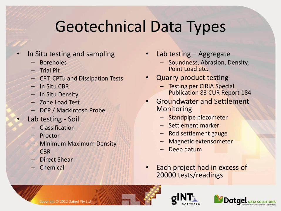
• In Situ testing and sampling – Boreholes – Trial Pit – CPT, CPTu and Dissipation Tests – In Situ CBR – In Situ Density – Zone Load Test – DCP / Mackintosh Probe
• Lab testing - Soil – Classification – Proctor – Minimum Maximum Density – CBR – Direct Shear – Chemical
• Lab testing – Aggregate – Soundness, Abrasion, Density,
Point Load etc.
• Quarry product testing – Testing per CIRIA Special
Publication 83 CUR Report 184
• Groundwater and Settlement Monitoring – Standpipe piezometer – Settlement marker – Rod settlement gauge – Magnetic extensometer – Deep datum
• Each project had in excess of
20000 tests/readings
Copyright © 2012 Datgel Pty Ltd
Geotechnical Data Management System (GDMS) Philosophy
• Store all of geotechnical data types, and calculate or manipulate the test parameters based on the raw data, metadata and calibration data.
• The advantages of this type of system are: – All data is stored in one central relational database, making it
easier to find and use data – Data is entered only once which minimises the risk of
transcription errors – Negates the need to import data calculated by a second
software application (e.g. Excel) – It gives more confidence in the correctness of the calculations,
as opposed to numerous individual spreadsheet files.
Copyright © 2012 Datgel Pty Ltd
Technology
• Windows Server with Remote Desktop Services • gINT Professional Version 8.1 and 8.2 • Datgel Administrator Tools • Datgel CPT Tool 2 • Datgel Fence and Map Tool 2 • Datgel Lab and In Situ Tool • Datgel Monitoring Tool • Datgel Output Tool 2 • Datgel Processor Affinity Manager • Datgel Photo Tool 2 • Datgel Secure Export Tool • Datgel Security Tool • Datgel Survey Tools • MapInfo and free GIS viewers
Copyright © 2012 Datgel Pty Ltd
Implementation and Support
• Development and support done on site and in Sydney.
• NDIA included Leeke Associates (UK) and gINT Software (USA).
• A lead analyst programmer with geotechnical knowledge on site improved the quality and speed of the system delivery – this was integral to the success of the software project.
• The first project required site time of around 3 months over 3 years, the most recent project required one site visit of 3 weeks.
• Addition of new product features in gINT and Datgel applications.
• Custom programming in VB.NET and C#.
• Support provided using phone, email, Skype, Webex which allowed us to remote control the site computers.
Copyright © 2012 Datgel Pty Ltd
Data Entry and Validation
• All data was entered or imported into the GDMS
• Data entry forms were optimised for speed of data entry
• Data was validated at input time:
– Type (number, text...)
– Allowable range
– Check sums
Copyright © 2012 Datgel Pty Ltd
Component Description
• Descriptions to British Standard
• Enforces consistency, such as of description order
• Improved data validation
• Simpler querying and filtering
Copyright © 2012 Datgel Pty Ltd
Specification Checks
• Automatically checked result requirement for a fill type
• Result acceptability visible to the user in the database
• Result acceptability printed on report
Copyright © 2012 Datgel Pty Ltd
Data Security and Approval
• The system ensured unapproved data was not provided electronically to the Engineer
• Restricted edit access to the data once it was approved
• Each PointID and test was assigned a status
• Each user was assigned to a user group with differing access rights
• Time saving tools were implemented to assist in approving data
Copyright © 2012 Datgel Pty Ltd
Surface and Original Ground Elevation Calculation
• When reviewing CPT results it was critical to know if the material was natural or fill.
• Initially this was done by referring to paper maps, however many thousands of CPTs were planned.
• The GDMS automated this task by importing the survey surface data, and automatically interpolating the original elevation for each CPT location.
Copyright © 2012 Datgel Pty Ltd
Maps
• The project layout was imported from DXF
• The GDMS’s GIS interface was used to interrogate the data
• Report quality maps were produced
Copyright © 2012 Datgel Pty Ltd
• Fence diagrams – Used to interpret data below sensitive structures
• Automatic lab descriptions – Lab samples were automatically described to
British Standard using the GDMS (based on PSD and Atterberg results)
• Custom Data Import Functions – CPT data directly from the CPT manufacturer’s
format
– Zone load test data logger files
– Excel
Copyright © 2012 Datgel Pty Ltd
Standard Reporting
• The GDMS produced all the standard reports for the geotechnical in situ, lab and monitoring data... >100 reports
• Filtering at output time allowed users to print data in certain areas, date ranges, geology types and/or results ranges
• Scripting of output runs were used for repetitive tasks and periodic reporting, such as monthly monitoring reports
Copyright © 2012 Datgel Pty Ltd
Ad hoc Analysis and Reporting in Excel
• Master data in the GDMS database • SQL queries were exported to excel • Using the “Get External Data” option in Excel
– Used to optimise the compaction process (Avsar et al
2006) and in situ mixing of silt with dune sand – Used to do further CPTu analysis for settlement and
liquefaction
Copyright © 2012 Datgel Pty Ltd
Electronic Data for Client Representative Engineer
• Clients required daily provision of electronic data
– AGS 3.1 Format data for newly approved data
– gINT Project files of all approved data
• The export was automated using Datgel Secure Export Tool
Copyright © 2012 Datgel Pty Ltd
Conclusions
• Enter data once and use it in many ways
• Managing, calculate, report and transfer geotechnical data from one system
• An efficient data management system will require less geotechnical engineers
• Our solution turned data into information for the contractor and client users.
• The efficient system allowed the contractor's geotechnical department to keep up with reporting for more than 4 million m³ per month of fill.
Copyright © 2012 Datgel Pty Ltd
Update on Geotechnical Data Interchange
• AGS Format is the most common geotechnical data interchange standard in use internationally. Developed in the UK by The Association of Geotechnical and Geoenvironmental Specialists.
• GEF, Geotechnical Exchange Format, developed in The Netherlands is used in Benelux for borehole data, and used world wide of CPT data.
• SGF, Swedish Geotechnical Format, is used in Sweden to interchange a range of in situ and lab testing data. Internationally it is used to interchange CPT data.
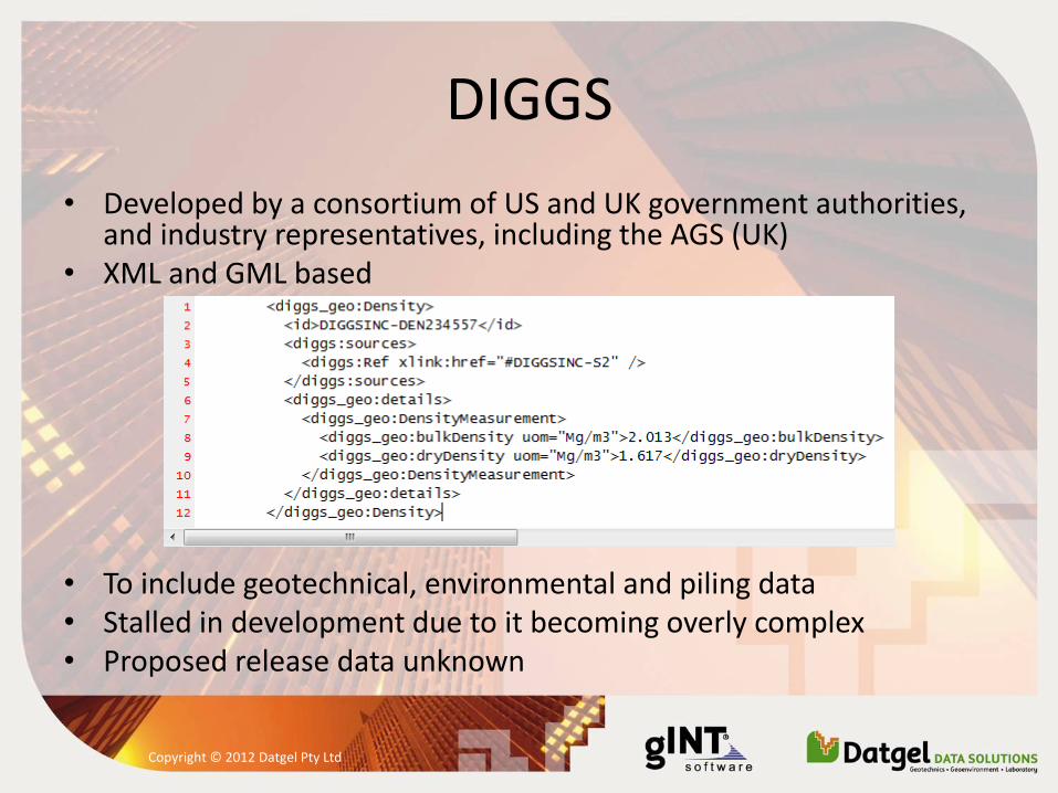
• DIGGS, Data Interchange for Geotechnical and GeoEnvironmental Specialists. XML and GML based standard, still under development and has not been used.
Copyright © 2012 Datgel Pty Ltd
AGS 3 and 3.1 Format
– AGS 3 released in 1999 – AGS 3.1 released in 2004 – AGS 3.1 addendum 1 released in 2005 – AGS 3.2 never officially released (developed from 2006) – AGS 3.1 RTA 1.1 released in 2006 and 2007 based on AGS 3.2, developed by
Datgel and the NSW Roads and Traffic Authority – AGS 3.2 NZ released in 2007 based on AGS RTA and AGS 3.2, never used – AGS 3.1 (SG) developed by the BCA with assistance from Datgel in 2011, not
released and not been used
• Used extensively in UK, Ireland, Middle East, Singapore, Hong Kong and Malaysia. Used since 2007 in NSW and occasionally other parts of Australia.
Copyright © 2012 Datgel Pty Ltd
AGS 4 Format
• Release – First released in May 2010 – Addendum March 2011 – Addendum May 2011 – Addendum October 2011
• Although it has been released for near on 2 years, it has not been enthusiastically adopted. Perhaps this is due to: – Economic problems in the UK – It needs to permeate in to government contracts
• During 2011 discussions began in New Zealand, Hong Kong and Australia about configuring local derivatives of AGS 4. NZ is close to releasing their standard.
Copyright © 2012 Datgel Pty Ltd
AGS 4 Format
• Significant changes compared to AGS 3.1
• File structural changes • Group renaming, e.g. HOLE is now LOCA • Addition key field for lab hierarchy • More lab test options • Introduction of data types • Is supported by common international geotechnical data
management software such as gINT and Holebase
Copyright © 2012 Datgel Pty Ltd
DIGGS
• Developed by a consortium of US and UK government authorities, and industry representatives, including the AGS (UK)
• XML and GML based
• To include geotechnical, environmental and piling data • Stalled in development due to it becoming overly complex • Proposed release data unknown
Copyright © 2012 Datgel Pty Ltd