Geotechnical Engineering Report Proposed Bertie High School Windsor, North Carolina February 20, 2012 Project No. 72125002 Prepared for: Bertie County Schools c/o Hite Associates Greenville, North Carolina Prepared by: Terracon Consultants, Inc. Winterville, North Carolina
Transcript
Geotechnical Engineering Report Proposed Bertie High School
Windsor, North Carolina February 20, 2012
Project No. 72125002
Prepared for: Bertie County Schools
c/o Hite Associates Greenville, North Carolina
Prepared by:
Terracon Consultants, Inc. Winterville, North Carolina
Terracon Consultants, Inc. 314 Beacon Drive Wintervi l le, North Carolina 28590 P [252] 353 1600 F [252] 353 0002 Terracon.com NC Registration Number F-0869
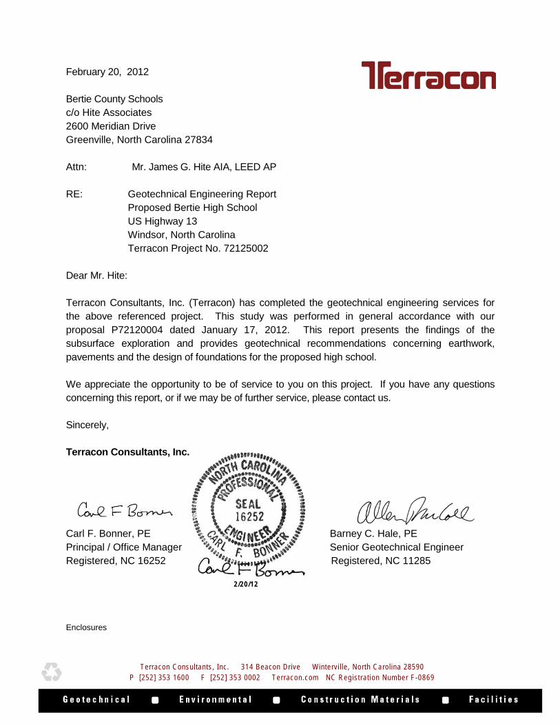
February 20, 2012 Bertie County Schools c/o Hite Associates 2600 Meridian Drive Greenville, North Carolina 27834 Attn: Mr. James G. Hite AIA, LEED AP RE: Geotechnical Engineering Report
Proposed Bertie High School US Highway 13 Windsor, North Carolina Terracon Project No. 72125002
Dear Mr. Hite: Terracon Consultants, Inc. (Terracon) has completed the geotechnical engineering services for the above referenced project. This study was performed in general accordance with our proposal P72120004 dated January 17, 2012. This report presents the findings of the subsurface exploration and provides geotechnical recommendations concerning earthwork, pavements and the design of foundations for the proposed high school. We appreciate the opportunity to be of service to you on this project. If you have any questions concerning this report, or if we may be of further service, please contact us. Sincerely, Terracon Consultants, Inc. Carl F. Bonner, PE Barney C. Hale, PE Principal / Office Manager Senior Geotechnical Engineer Registered, NC 16252 Registered, NC 11285 Enclosures
Terracon Consultants, Inc. 314 Beacon Drive Wintervi l le, North Carolina 28590 P [252] 353 1600 F [252] 353 0002 Terracon.com NC Registration Number F-0869
2/20/12
Geotechnical Engineering Report Bertie High School ■ Windsor, North Carolina February 20, 2012 ■ Terracon Project No. 72125002
Responsive ■ Resourceful ■ Reliable
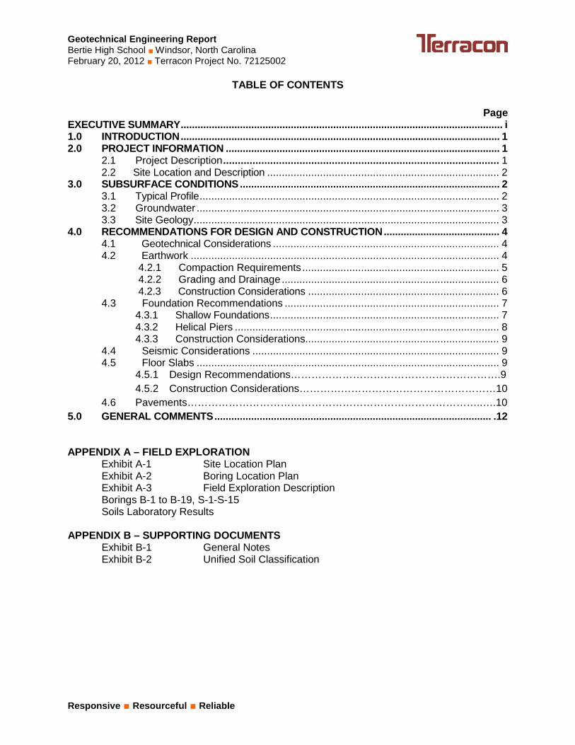
TABLE OF CONTENTS
Page EXECUTIVE SUMMARY .................................................................................................................. i 1.0 INTRODUCTION ................................................................................................................. 1 2.0 PROJECT INFORMATION ................................................................................................. 1
2.1 Project Description .............................................................................................. 1 2.2 Site Location and Description ............................................................................... 2
4.5.1 Design Recommendations…………………………………………………….9 4.5.2 Construction Considerations…………………………………………………10 4.6 Pavements…………………………………………………………………………..….10 5.0 GENERAL COMMENTS .................................................................................................. .12 APPENDIX A – FIELD EXPLORATION
Exhibit A-1 Site Location Plan Exhibit A-2 Boring Location Plan Exhibit A-3 Field Exploration Description Borings B-1 to B-19, S-1-S-15 Soils Laboratory Results
APPENDIX B – SUPPORTING DOCUMENTS Exhibit B-1 General Notes Exhibit B-2 Unified Soil Classification
Geotechnical Engineering Report Bertie High School ■ Windsor, North Carolina February 20, 2012 ■ Terracon Project No. 72125002
Responsive ■ Resourceful ■ Reliable
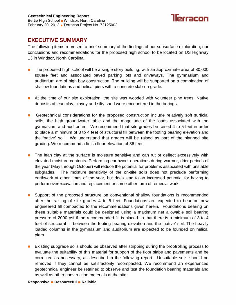
EXECUTIVE SUMMARY The following items represent a brief summary of the findings of our subsurface exploration, our conclusions and recommendations for the proposed high school to be located on US Highway 13 in Windsor, North Carolina. The proposed high school will be a single story building, with an approximate area of 80,000
square feet and associated paved parking lots and driveways. The gymnasium and auditorium are of high bay construction. The building will be supported on a combination of shallow foundations and helical piers with a concrete slab-on-grade.
At the time of our site exploration, the site was wooded with volunteer pine trees. Native
deposits of lean clay, clayey and silty sand were encountered in the borings. Geotechnical considerations for the proposed construction include relatively soft surficial
soils, the high groundwater table and the magnitude of the loads associated with the gymnasium and auditorium. We recommend that site grades be raised 4 to 5 feet in order to place a minimum of 3 to 4 feet of structural fill between the footing bearing elevation and the ‘native’ soil. We understand that grades will be raised as part of the planned site grading. We recommend a finish floor elevation of 36 feet.
The lean clay at the surface is moisture sensitive and can rut or deflect excessively with
elevated moisture contents. Performing earthwork operations during warmer, drier periods of the year (May through October) will reduce the potential for problems associated with unstable subgrades. The moisture sensitivity of the on-site soils does not preclude performing earthwork at other times of the year, but does lead to an increased potential for having to perform overexcavation and replacement or some other form of remedial work.
Support of the proposed structure on conventional shallow foundations is recommended
after the raising of site grades 4 to 5 feet. Foundations are expected to bear on new engineered fill compacted to the recommendations given herein. Foundations bearing on these suitable materials could be designed using a maximum net allowable soil bearing pressure of 2000 psf if the recommended fill is placed so that there is a minimum of 3 to 4 feet of structural fill between the footing bearing elevation and the ‘native’ soil. The heavily loaded columns in the gymnasium and auditorium are expected to be founded on helical piers.
Existing subgrade soils should be observed after stripping during the proofrolling process to
evaluate the suitability of this material for support of the floor slabs and pavements and be corrected as necessary, as described in the following report. Unsuitable soils should be removed if they cannot be satisfactorily recompacted. We recommend an experienced geotechnical engineer be retained to observe and test the foundation bearing materials and as well as other construction materials at the site.
Geotechnical Engineering Report Bertie High School ■ Windsor, North Carolina February 20, 2012 ■ Terracon Project No. 72125002
Responsive ■ Resourceful ■ Reliable
This summary should be used in conjunction with the entire report for design purposes. Details were not included or fully developed in this section, and the report must be read in its entirety for a comprehensive understanding of the items contained herein. The section titled GENERAL COMMENTS should be read for an understanding of report limitations.
Responsive ■ Resourceful ■ Reliable 1
GEOTECHNICAL ENGINEERING REPORT BERTIE HIGH SCHOOL
WINDSOR, NORTH CAROLINA Terracon Project No. 72125002
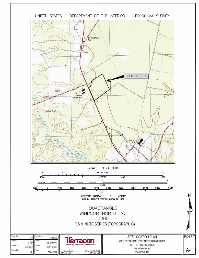
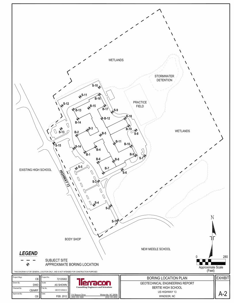
February 20, 2012 1.0 INTRODUCTION A geotechnical engineering report has been completed for the proposed high school to be located on US Highway 13 in Windsor, North Carolina. Thirty four borings were performed to depths of approximately 5 to 85 feet below the existing ground surface at the requested locations. Logs of the borings along with a site location plan and a boring location plan are included in Appendix A of this report. The purpose of these services is to provide information and geotechnical engineering recommendations relative to: subsurface soil conditions foundation design and construction groundwater conditions earthwork
seismic considerations floor slab design and construction
pavements
2.0 PROJ ECT INFORMATION
Project information was obtained from our review of electronic correspondence from Mr. James G. Hite, architect, dated January 11, 2012, an attached drawing, a telephone conversation with Mr. Jack Deese, of JDA Engineering, a site visit and a subsequent telephone conversations with Mr. Brad Williams of Hite Associates. We understand that a new high school is planned for an undeveloped site across Highway 13 from the existing high school in Windsor, North Carolina. 2.1 Projec t Des c rip tion
ITEM DESCRIPTION Site Location See Appendix A, Exhibit A-1, Site Location Plan
Site layout See Appendix A, Exhibit A-2, Boring Location Plan
Structure Single story, approximately 80,000 square feet with associated paved parking lot and driveways. The gymnasium and auditorium are of high bay construction.
Geotechnical Engineering Report Bertie High School ■ Windsor, North Carolina February 20, 2012 ■ Terracon Project No. 72125002
Responsive ■ Resourceful ■ Reliable 2
ITEM DESCRIPTION
Building Construction Load bearing masonry walls and isolated steel columns supported on shallow foundations or helical piers with a concrete-slab-on grade
Maximum loads
Columns: Maximum column loads of 175 kips, most columns in the range of 30 to 45 kips (per JDA Engineering) Walls: 3 kips per linear foot (per JDA Engineering) Slab: 100 psf (assumed)
Maximum allowable settlement Up to 1-inch Total and up to 3/4-inch differential over 40 feet (assumed)
Grading Finish floor elevation was not provided. We recommend a finish floor elevation of 36 feet. Up to 4 to 5 feet of fill recommended.
Fill slopes 3H:1V (Horizontal to Vertical) max (assumed)
Retaining walls None
Below grade levels None 2.2 Site Location and Des cription
ITEM DESCRIPTION
Location The proposed Bertie High School will be located on US Highway 13, across from the existing high school, north of Windsor, North Carolina.
Existing improvements Undeveloped
Current ground cover Wooded with volunteer pines, approximately 4 to 6 inches in diameter
Existing topography Relatively level, with some swales observed 3.0 SUBSURFACE CONDITIONS 3.1 Typica l Profile Based on the results of the boring, subsurface conditions on the project site can be generalized as follows:
Description Approximate Depth to Bottom of Stratum (feet) Material Encountered Consistency/Density
Surface 1.0 Vegetation / Topsoil /
Rootmat N/A
Stratum 1 13 Lean Clay (CL) and Fat
Clay (CH) Soft to Medium Stiff
Geotechnical Engineering Report Bertie High School ■ Windsor, North Carolina February 20, 2012 ■ Terracon Project No. 72125002
Responsive ■ Resourceful ■ Reliable 3
Stratum 2 28 Clayey Sand (SC) Fine to Medium Sand (SP) and Silty Sand (SM)
Very Loose to Medium Dense
Stratum 3 82 Lean Clay (CL) and Fat
Clay (CH) Stiff to Very Stiff
Stratum 4 83 Limestone Very Dense
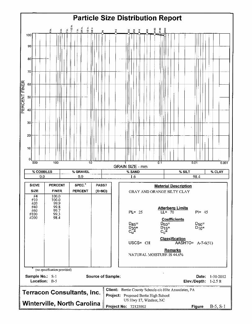
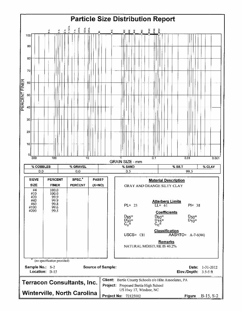
Laboratory classification testing was performed on three samples from borings B-5, B-8 and B-15 from 1 to 2.5 feet and 3.5 to 5 feet. The samples were classified as Fat Clay (CH). The laboratory test results are listed in Appendix A and on the boring logs.
Conditions encountered at the boring locations are indicated on the boring logs. Stratification boundaries on the boring logs represent the approximate location of changes in soil types; in-situ, the transition between materials may be gradual and indistinct. Conditions can also vary between boring locations. Further details of the borings can be found on the boring logs in Appendix A of this report. 3.2 Groundwate r A mixture of water and “drilling mud” was used to advance the borings. The fluid used in this process can obscure the measurements of groundwater levels. However, after a period of time, the fluid typically stabilizes at a depth near the groundwater level. The boreholes were observed while drilling and after completion for the presence and level of groundwater. Groundwater levels were observed at a depth of approximately 1 to 3 feet in the borings while drilling. The moisture condition of the soil samples supported these groundwater levels. Groundwater level fluctuations on the order of one to three feet occur due to seasonal variations in the amount of rainfall, runoff and other factors not evident at the time the borings were performed. Therefore, groundwater levels during construction or at other times in the life of the structure may be higher or lower than the levels indicated on the boring logs. The possibility of groundwater level fluctuations should be considered when developing the design and construction plans for the project. If seasonal high water table information and infiltration rates are required for the design of a stormwater detention system, we recommend that a soil scientist be retained for additional investigation. 3.3 Site Geology The subject site is located in the Coastal Plain Physiographic Province. The Coastal Plain soils consist mainly of marine sediments that were deposited during successive periods of fluctuating sea level and moving shoreline. The soils include sands, silts, and clays with irregular deposits of shells, which are typical of those lain down in a shallow sloping sea bottom. Recent alluvial sands,
Geotechnical Engineering Report Bertie High School ■ Windsor, North Carolina February 20, 2012 ■ Terracon Project No. 72125002
Responsive ■ Resourceful ■ Reliable 4
silts, and clays are typically present near rivers and creeks. According to the 1985 Geologic Map of North Carolina, the site is mapped within the Yorktown and Duplin Formation. 4.0 RECOMMENDATIONS FOR DESIGN AND CONSTRUCTION 4.1 Geotechnica l Cons idera tions Geotechnical considerations for the proposed construction include relatively soft surficial soils, the high groundwater table and the magnitude of the loads associated with the gymnasium and auditorium. We recommend that site grades be raised 4 to 5 feet in order to place a minimum of 3 to 4 feet of structural fill between the footing bearing elevation and the ‘native’ soil. We understand that grades will be raised as part of the planned site grading. We recommend a finish floor elevation of 36 feet. It should be understood that the recommendations of this report are contingent upon the understanding that site grades will be raised 4 to 5 feet. If site grades are not raised, Terracon should be contacted so that supplemental recommendations can be provided. The near-surface fat clay and lean clay are moisture-sensitive and will lose strength and rut or deflect excessively under construction traffic when they become wet. Performing earthwork operations during warmer, drier periods of the year (May through October) will reduce the potential for problems associated with unstable subgrades. The moisture sensitivity of the on-site soils does not preclude performing earthwork at other times of the year, but does lead to an increased potential for having to perform overexcavation and replacement or some other form of remedial work. Protecting the exposed subgrade soils from infiltration of surface water by keeping the site grades sloped to promote runoff in advance of rain events will also reduce the potential for needing to perform remedial work on wet subgrades. Should unstable subgrade conditions develop, stabilization measures should be employed. Support of the proposed structure on conventional shallow foundations is recommended after the raising of site grades 4 to 5 feet. Foundations are expected to bear on new engineered fill compacted to the recommendations given herein. Foundations bearing on these suitable materials could be designed using a maximum net allowable soil bearing pressure of 2000 psf if the recommended fill is placed so that there is a minimum of 3 to 4 feet of structural fill between the footing bearing elevation and the ‘native’ soil. The heavily loaded columns in the gymnasium and auditorium are expected to be founded on helical piers. 4.2 Earthwork
Site preparation should begin with the complete removal of the existing surface vegetation. Grass, topsoil and rootmat at the ground surface should be stripped to a depth of approximately 6 inches. Stripping depth should be monitored and minimized in order to maintain the vertical
Geotechnical Engineering Report Bertie High School ■ Windsor, North Carolina February 20, 2012 ■ Terracon Project No. 72125002
Responsive ■ Resourceful ■ Reliable 5
separation between the surface grades and the water table. A Terracon representative should field verify the stripping depth during construction. Topsoil may be re-used in areas of the site to be landscaped. Topsoil should not be used as structural fill or backfill. After stripping, the exposed subgrade soils in areas to receive fill or at the subgrade elevation in cut areas should be proofrolled with an empty, tandem-axle dump truck or similar rubber-tired construction equipment. Proofrolling is recommended as a means of detecting areas of soft or unstable subgrade soils. The proofrolling should be performed during a period of dry weather to avoid degrading an otherwise suitable subgrade. The proofrolling operations should be observed by a representative of the geotechnical engineer. Subgrade soils that exhibit excessive rutting or deflection during proofrolling should be overexcavated as directed by the representative and replaced with properly compacted fill. Areas of localized undercut are likely to be required. Engineered fill should meet the following material property requirements:
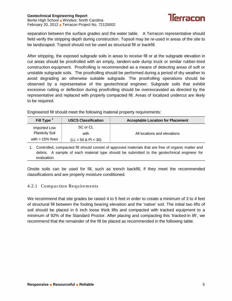
Fill Type 1 USCS Classification Acceptable Location for Placement
Imported Low Plasticity Soil
with > 15% fines
SC or CL with
(LL < 50 & PI < 30) All locations and elevations
1. Controlled, compacted fill should consist of approved materials that are free of organic matter and debris. A sample of each material type should be submitted to the geotechnical engineer for evaluation.
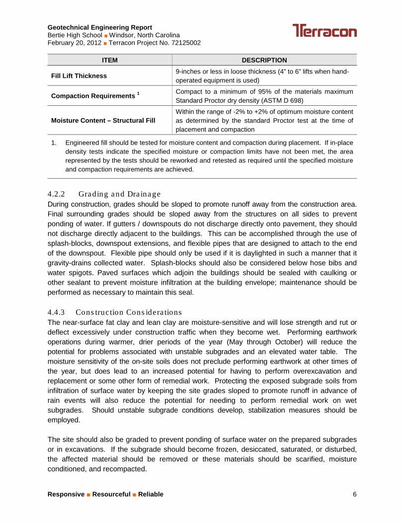
Onsite soils can be used for fill, such as trench backfill, if they meet the recommended classifications and are properly moisture conditioned. 4.2.1 Compac tion Requirements We recommend that site grades be raised 4 to 5 feet in order to create a minimum of 3 to 4 feet of structural fill between the footing bearing elevation and the ‘native’ soil. The initial two lifts of soil should be placed in 6 inch loose thick lifts and compacted with tracked equipment to a minimum of 92% of the Standard Proctor. After placing and compacting this ‘tracked-in lift’, we recommend that the remainder of the fill be placed as recommended in the following table.
Geotechnical Engineering Report Bertie High School ■ Windsor, North Carolina February 20, 2012 ■ Terracon Project No. 72125002
Responsive ■ Resourceful ■ Reliable 6
ITEM DESCRIPTION
Fill Lift Thickness 9-inches or less in loose thickness (4” to 6” lifts when hand-operated equipment is used)
Compaction Requirements 1 Compact to a minimum of 95% of the materials maximum Standard Proctor dry density (ASTM D 698)
Moisture Content – Structural Fill Within the range of -2% to +2% of optimum moisture content as determined by the standard Proctor test at the time of placement and compaction
1. Engineered fill should be tested for moisture content and compaction during placement. If in-place density tests indicate the specified moisture or compaction limits have not been met, the area represented by the tests should be reworked and retested as required until the specified moisture and compaction requirements are achieved.
4.2.2 Grading and Dra inage During construction, grades should be sloped to promote runoff away from the construction area. Final surrounding grades should be sloped away from the structures on all sides to prevent ponding of water. If gutters / downspouts do not discharge directly onto pavement, they should not discharge directly adjacent to the buildings. This can be accomplished through the use of splash-blocks, downspout extensions, and flexible pipes that are designed to attach to the end of the downspout. Flexible pipe should only be used if it is daylighted in such a manner that it gravity-drains collected water. Splash-blocks should also be considered below hose bibs and water spigots. Paved surfaces which adjoin the buildings should be sealed with caulking or other sealant to prevent moisture infiltration at the building envelope; maintenance should be performed as necessary to maintain this seal. 4.4.3 Cons truction Cons idera tions The near-surface fat clay and lean clay are moisture-sensitive and will lose strength and rut or deflect excessively under construction traffic when they become wet. Performing earthwork operations during warmer, drier periods of the year (May through October) will reduce the potential for problems associated with unstable subgrades and an elevated water table. The moisture sensitivity of the on-site soils does not preclude performing earthwork at other times of the year, but does lead to an increased potential for having to perform overexcavation and replacement or some other form of remedial work. Protecting the exposed subgrade soils from infiltration of surface water by keeping the site grades sloped to promote runoff in advance of rain events will also reduce the potential for needing to perform remedial work on wet subgrades. Should unstable subgrade conditions develop, stabilization measures should be employed. The site should also be graded to prevent ponding of surface water on the prepared subgrades or in excavations. If the subgrade should become frozen, desiccated, saturated, or disturbed, the affected material should be removed or these materials should be scarified, moisture conditioned, and recompacted.
Geotechnical Engineering Report Bertie High School ■ Windsor, North Carolina February 20, 2012 ■ Terracon Project No. 72125002
Responsive ■ Resourceful ■ Reliable 7
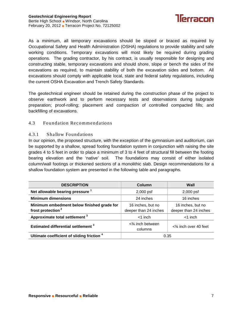
As a minimum, all temporary excavations should be sloped or braced as required by Occupational Safety and Health Administration (OSHA) regulations to provide stability and safe working conditions. Temporary excavations will most likely be required during grading operations. The grading contractor, by his contract, is usually responsible for designing and constructing stable, temporary excavations and should shore, slope or bench the sides of the excavations as required, to maintain stability of both the excavation sides and bottom. All excavations should comply with applicable local, state and federal safety regulations, including the current OSHA Excavation and Trench Safety Standards. The geotechnical engineer should be retained during the construction phase of the project to observe earthwork and to perform necessary tests and observations during subgrade preparation; proof-rolling; placement and compaction of controlled compacted fills; and backfilling of excavations. 4.3 Founda tion Recommenda tions 4.3.1 Shallow Foundations In our opinion, the proposed structure, with the exception of the gymnasium and auditorium, can be supported by a shallow, spread footing foundation system in conjunction with raising the site grades 4 to 5 feet in order to place a minimum of 3 to 4 feet of structural fill between the footing bearing elevation and the ‘native’ soil. The foundations may consist of either isolated column/wall footings or thickened sections of a monolithic slab. Design recommendations for a shallow foundation system are presented in the following table and paragraphs.
DESCRIPTION Column Wall
Net allowable bearing pressure 1 2,000 psf 2,000 psf
Minimum dimensions 24 inches 16 inches
Minimum embedment below finished grade for frost protection 2
16 inches, but no deeper than 24 inches
16 inches, but no deeper than 24 inches
Approximate total settlement 3 <1 inch <1 inch
Estimated differential settlement 3 <¾ inch between columns
<¾ inch over 40 feet
Ultimate coefficient of sliding friction 4 0.35
Geotechnical Engineering Report Bertie High School ■ Windsor, North Carolina February 20, 2012 ■ Terracon Project No. 72125002
Responsive ■ Resourceful ■ Reliable 8
1. The recommended net allowable bearing pressure is the pressure in excess of the minimum surrounding overburden pressure at the footing base elevation. Assumes any unsuitable fill or soft soils, if encountered, will be undercut and replaced with engineered fill.
2. And to reduce the effects of seasonal moisture variations in the subgrade soils. For perimeter footing and footings beneath unheated areas.
3. The foundation settlement will depend upon the variations within the subsurface soil profile, the structural loading conditions, the embedment depth of the footings, the thickness of compacted fill, and the quality of the earthwork operations.
For uplift resistance, use the weight of the foundation concrete plus the weight of the soil over the plan area of the footings. 110 pounds per cubic foot should be used for the density of the soil.
4.3.2 He lica l P iers For the more heavily loaded columns in the gymnasium and auditorium, we recommend the placement of helical piers. We expect helical piers extending into the sand layer to a depth of 17 to 20 feet could achieve a design capacity of 25 kips per pier. Anticipated pier design would include clusters of three to five helical piers at each interior column. As a preliminary design, the helical piers should have 14 inch helical flight plates, a minimum 2 7/8 inch diameter pipe with 0.25 inch wall thickness and 10 foot bolted extensions with grouted shafts. The helical pier installer should use their system to develop the final design details. Load testing of the test piers is recommended to verify that the contractor’s construction methods and installation equipment can produce a foundation which will perform satisfactorily. We recommend that one pier in each area (gymnasium and auditorium) be tested. The geotechnical engineer should be retained to select the test pier to be load tested, witness the load test, analyze and report the load test results and develop recommendations for production foundation depths and installation procedures. The load test should be performed in general accordance with ASTM D 1143. The pier should be loaded to failure or at least 2.5 times the design capacity, whichever occurs first. Accurate deflection measurements should be made using at least two independent systems. 4.3.3 Cons truc tion Cons ide ra tions The foundation bearing condition for shallow footings should be evaluated at the time of the foundation excavation. A representative of the geotechnical engineer should use a combination of hand auger borings and dynamic cone penetrometer (DCP) testing to determine the suitability of the bearing materials for the design bearing pressure. DCP testing should be performed to a depth of 3 feet below the bottom of footing excavation. Excessively soft, loose or wet bearing soils should be overexcavated to a depth recommended by the geotechnical engineer. The footings
Geotechnical Engineering Report Bertie High School ■ Windsor, North Carolina February 20, 2012 ■ Terracon Project No. 72125002
Responsive ■ Resourceful ■ Reliable 9
could then bear directly on these soils at the lower level or the excavated soils could be replaced with compacted soil fill or washed, crushed stone (NCDOT No. 57). The washed, crushed stone should be wrapped with geotextile fabric to limit the erosion of sand into the stone. Hand auger borings and DCP testing will not be required for the footings supported by helical piers. The base of all foundation excavations should be free of water and loose soil prior to placing concrete. Concrete should be placed soon after excavating to reduce bearing soil disturbance. Should the soils at bearing level become excessively disturbed or saturated, the affected soil should be removed prior to placing concrete. 4.4 Se is mic Cons ide ra tions
Code Used Site Classification
2006 International Building Code (IBC)1
2009 North Carolina Building Code E
1. In general accordance with Table 1613.5.2 of the 2006 IBC, modified by North Carolina.
Based on our exploration of the upper 85 feet of the soil profile, it is our opinion that the subsurface characteristics reflect those of Site Class E as described in the 2009 North Carolina State Building Code. The seismic site classification could be further evaluated and potentially improved by developing the shear wave velocity profile to a depth of 100 feet. 4.5 Floor S labs 4.5.1 Des ign Recommenda tions
ITEM DESCRIPTION
Floor slab support Approved existing soils or new engineered fill
Modulus of subgrade reaction 150 pounds per square inch per inch (psi/in) for point loading conditions
Aggregate base course/capillary break 4 to 6 inches of free draining granular material (NCDOT No. 57 or recycled concrete)
Saw-cut control joints should be placed in the slab to help control the location and extent of cracking. For additional recommendations refer to the ACI Design Manual. The use of a vapor retarder should be considered beneath concrete slabs on grade that will be covered with wood, tile, carpet or other moisture sensitive or impervious coverings. The slab
Geotechnical Engineering Report Bertie High School ■ Windsor, North Carolina February 20, 2012 ■ Terracon Project No. 72125002
Responsive ■ Resourceful ■ Reliable 10
designer should refer to ACI 302 and/or ACI 360 for procedures and cautions regarding the use and placement of a vapor retarder. 4.5.2 Cons truc tion Cons idera tions On most project sites, the site grading is generally accomplished early in the construction phase. However as construction proceeds, the subgrade may be disturbed due to utility excavations, construction traffic, desiccation, rainfall, etc. If such disturbance occurs, the floor slab subgrade may not be suitable for placement of the capillary break layer and concrete and corrective action will be required. We recommend the floor slab subgrade be rough graded and then thoroughly proofrolled with a moderately loaded tandem axle dump truck prior to final grading and placement of the capillary break layer. Particular attention should be paid to high traffic areas that were rutted and disturbed by construction activities and to areas where backfilled trenches are located. Areas where unsuitable conditions are located should be repaired by removing and replacing the affected material with properly compacted fill. Floor slab subgrade areas should be moisture conditioned and properly compacted to the recommendations in this report immediately prior to placement of the aggregate base course and concrete. 4.6 Pavements 4.6.1 Pavement Subgrades The pavement subgrade should be stripped and then proofrolled as outlined in section 4.2 Earthwork of this report. Loose or excessively wet soils delineated by the proofrolling operations should be undercut and backfilled as directed by the geotechnical engineer. The use of a geotechnical fabric and crushed stone is also a potential option for subgrade improvement. Upon completion of any necessary remediation, the subgrade should be adequate for support of the pavement sections recommended below. Pavement thickness design is dependent upon:
• the anticipated traffic conditions during the life of the pavement; • subgrade and paving material characteristics; • climatic conditions of the region
We recommend that if borrow soils are used to raise site grades in the parking lot and driveways that they be tested for CBR to confirm suitability of pavement section before fine grading. Asphaltic concrete pavements can be used for pavements such as drive lanes and parking areas. Recommended minimum thicknesses for light duty and standard duty areas are provided in the table below.
Geotechnical Engineering Report Bertie High School ■ Windsor, North Carolina February 20, 2012 ■ Terracon Project No. 72125002
Responsive ■ Resourceful ■ Reliable 11
Material Light Duty Pavement Section1 Standard Duty Pavement Section2
Asphalt Surface Course3 3 inches (minimum-placed in 2 lifts)
1.5 inches (minimum)
Asphalt Base Course4 -- 2.5 inches (minimum)
Aggregate Base Course5 6 inches (minimum) 8 inches (minimum)
1. Light-duty asphaltic concrete parking areas serving only personal vehicle traffic 2. Standard-duty asphaltic concrete pavements for drive lanes and buses 3. NCDOT Type SF-9.5A 4. NCDOT Type I-19.0B 5. Crushed Stone NCDOT ABC, Type A or B
We recommend PCC pavements for entrance aprons, trash container pads, and in any other areas subjected to heavy wheel loads and/or turning traffic. Recommended minimum PCC pavement sections are provided in the table below.
1. Pavement section for trash collection areas and other heavy traffic areas 2. PCC should have a minimum 28 day compressive strength of 4,000 psi, air entrainment of 5 to
7%, and be placed with a maximum slump of 4 inches. 3. Crushed stone (NCDOT ABC, Type A or B)
Standard duty pavement is recommended for the entrance road extending to the dumpster pad and truck delivery/unloading area and the bus loop and parking areas. Light duty pavement is recommended for the automobile parking areas.
For areas subject to concentrated and repetitive loading conditions, i.e. dumpster pads and ingress/egress aprons, we recommend using a Portland cement concrete pavement with a thickness of at least 7 inches underlain by at least 4 inches of crushed stone. For dumpster pads, the concrete pavement area should be large enough to support the container and tipping axle of the refuse truck. The placement of a partial pavement thickness for use during construction is not suggested without a detailed pavement analysis incorporating construction traffic.
Geotechnical Engineering Report Bertie High School ■ Windsor, North Carolina February 20, 2012 ■ Terracon Project No. 72125002
Responsive ■ Resourceful ■ Reliable 12
Recommendations for pavement construction presented depend upon compliance with recommended material specifications. To assess compliance, observation and testing should be performed under the direction of the geotechnical engineer. Pavements and bases should be constructed in accordance with the guidelines of the North Carolina Department of Transportation “Standard Specifications for Roads and Structures”. Materials, weather limitations, placement, and compaction are specified under appropriate sections of this publication. Concrete pavement should be air-entrained and have a minimum compressive strength of 4,000 psi after 28 days of laboratory curing per ASTM C-31. The performance of all pavements can be enhanced by minimizing excess moisture which can reach the subgrade soils. The following recommendations should be considered a minimum:
• site grading at a minimum 2 percent grade away from the pavements; • the subgrade and the pavement surface have a minimum 1/4 inch per foot slope to
promote proper surface drainage; • install joint sealant and seal cracks immediately; place curb, gutter and/or sidewalk
directly on subgrade soils without the use of base course materials.
Prevention of infiltration of water into the subgrade is essential for the successful performance of any pavement. Both the subgrade and the pavement surface should be sloped to promote surface drainage away from the pavement structure. Preventive maintenance should be planned and provided for an on-going pavement management program in order to enhance future pavement performance. Preventive maintenance activities are intended to slow the rate of pavement deterioration, and to preserve the pavement investment. Preventive maintenance of concrete pavement typically consists of filling cracks that develop. Preventive maintenance is usually the first priority when implementing a planned pavement maintenance program and provides the highest return on investment for pavements. Prior to implementing any maintenance, additional engineering observation is recommended to determine the type and extent of preventive maintenance most applicable to the proposed project. 5.0 GENERAL COMMENTS
Terracon should be retained to review the final design plans and specifications so comments can be made regarding interpretation and implementation of our geotechnical recommendations in the design and specifications. Terracon also should be retained to provide observation and testing services during grading, excavation, foundation construction and other earth-related construction phases of the project.
Geotechnical Engineering Report Bertie High School ■ Windsor, North Carolina February 20, 2012 ■ Terracon Project No. 72125002
Responsive ■ Resourceful ■ Reliable 13
The analysis and recommendations presented in this report are based upon the data obtained from the borings performed at the indicated locations and from other information discussed in this report. This report does not reflect variations that may occur between borings, across the site, or due to the modifying effects of construction or weather. The nature and extent of such variations may not become evident until during or after construction. If variations appear, we should be immediately notified so that further evaluation and supplemental recommendations can be provided. The scope of services for this project does not include either specifically or by implication any environmental or biological (e.g., mold, fungi, bacteria) assessment of the site or identification or prevention of pollutants, hazardous materials or conditions. If the owner is concerned about the potential for such contamination or pollution, other studies should be undertaken. This report has been prepared for the exclusive use of our client for specific application to the project discussed and has been prepared in accordance with generally accepted geotechnical engineering practices. No warranties, either express or implied, are intended or made. Site safety, excavation support, and dewatering requirements are the responsibility of others. In the event that changes in the nature, design, or location of the project as outlined in this report are planned, the conclusions and recommendations contained in this report shall not be considered valid unless Terracon reviews the changes and either verifies or modifies the conclusions of this report in writing.
APPENDIX A FIELD EXPLORATION
SS
SS
SS
SS
SS
SS
SS
CL
CL
SC
CL
SP
SC
SC
1
2
3
4
5
6
7
4
5
2
2
15
2
10
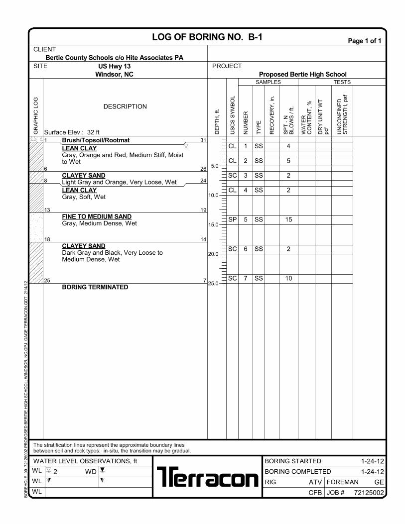
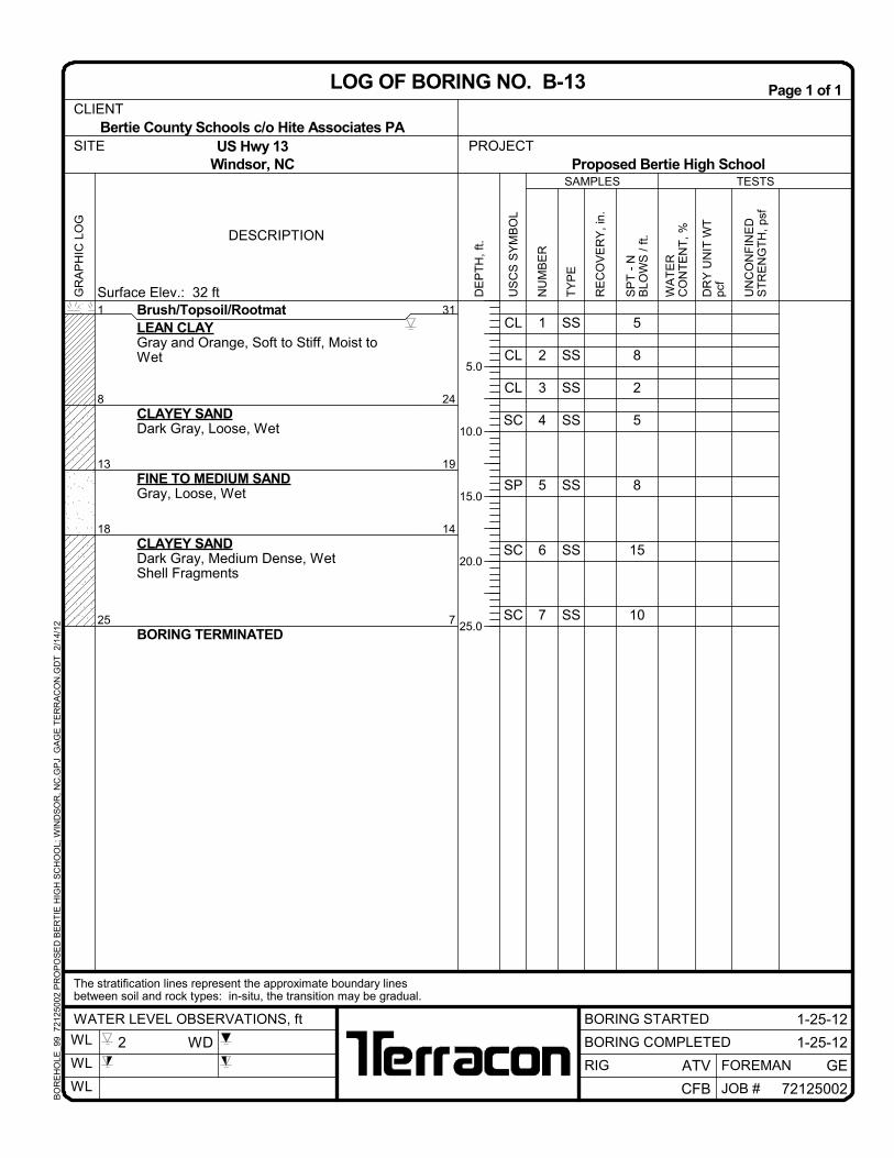
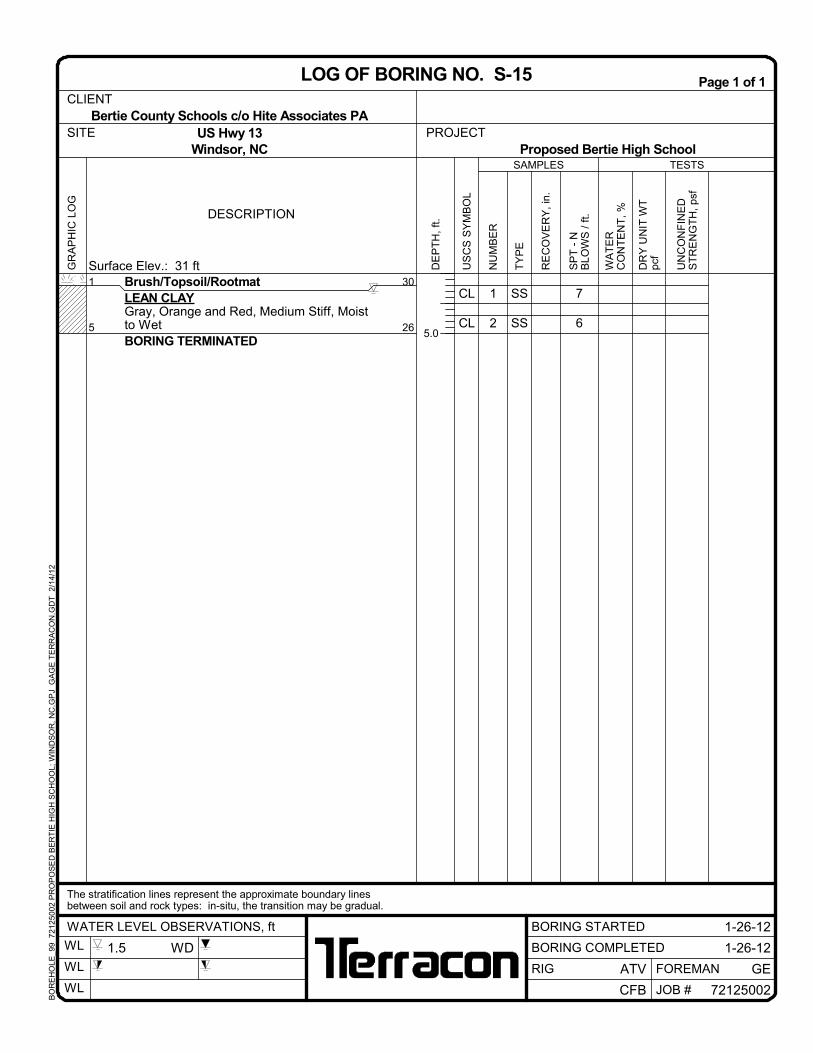
Brush/Topsoil/RootmatLEAN CLAYGray, Orange and Red, Medium Stiff, Moistto Wet
CLAYEY SANDLight Gray and Orange, Very Loose, WetLEAN CLAYGray, Soft, Wet
FINE TO MEDIUM SANDGray, Medium Dense, Wet
CLAYEY SANDDark Gray and Black, Very Loose toMedium Dense, Wet
BORING TERMINATED
1
6
8
13
18
25
31
26
24
19
14
7
TESTS
DESCRIPTION
UN
CO
NF
INE
DS
TR
EN
GT
H,
psf
Surface Elev.: 32 ft
SAMPLES
US
CS
SY
MB
OL
WA
TE
RC
ON
TE
NT
, %
TY
PE
NU
MB
ER
DE
PT
H,
ft.
RE
CO
VE
RY
, in
.
SP
T -
NB
LOW
S /
ft.
DR
Y U
NIT
WT
pcf
5.0
10.0
15.0
20.0
25.0
PROJECT
1-24-12WATER LEVEL OBSERVATIONS, ft
GR
AP
HIC
LO
GPage 1 of 1
BORING COMPLETED
CFB
GEFOREMANRIG
1-24-12
72125002
Bertie County Schools c/o Hite Associates PACLIENT
LOG OF BORING NO. B-1
US Hwy 13Windsor, NC
The stratification lines represent the approximate boundary linesbetween soil and rock types: in-situ, the transition may be gradual.
Proposed Bertie High SchoolSITE
BORING STARTED
ATV
WL
WL
WL JOB #
2 WD
BO
RE
HO
LE_9
9 7
212
5002
PR
OP
OS
ED
BE
RT
IE H
IGH
SC
HO
OL;
WIN
DS
OR
, NC
.GP
J G
AG
E T
ER
RA
CO
N.G
DT
2/
14/1
2
SS
SS
SS
SS
SS
SS
SS
CL
CL
CL
CL
SC
SC
CL
1
2
3
4
5
6
7
6
5
3
2
4
17
10
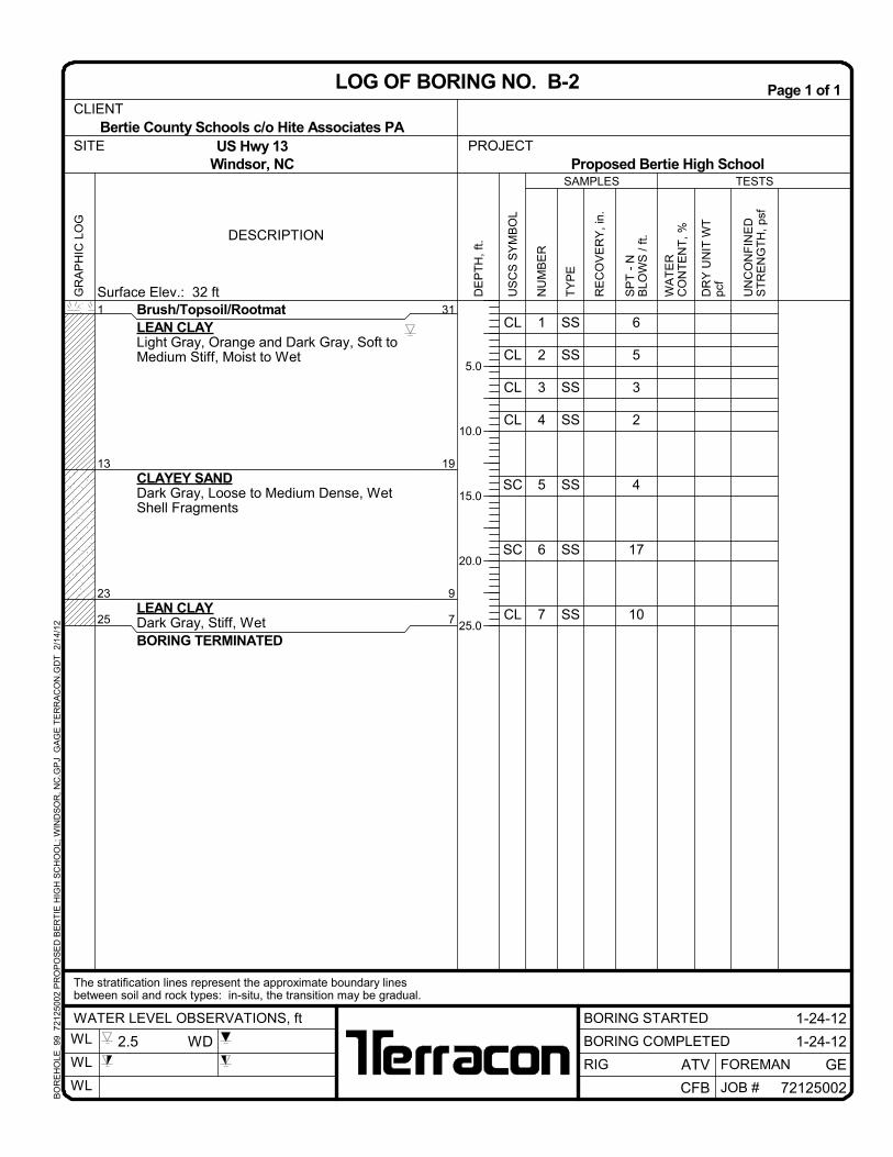
Brush/Topsoil/RootmatLEAN CLAYLight Gray, Orange and Dark Gray, Soft toMedium Stiff, Moist to Wet
CLAYEY SANDDark Gray, Loose to Medium Dense, WetShell Fragments
LEAN CLAYDark Gray, Stiff, WetBORING TERMINATED
1
13
23
25
31
19
9
7
TESTS
DESCRIPTION
UN
CO
NF
INE
DS
TR
EN
GT
H,
psf
Surface Elev.: 32 ft
SAMPLES
US
CS
SY
MB
OL
WA
TE
RC
ON
TE
NT
, %
TY
PE
NU
MB
ER
DE
PT
H,
ft.
RE
CO
VE
RY
, in
.
SP
T -
NB
LOW
S /
ft.
DR
Y U
NIT
WT
pcf
5.0
10.0
15.0
20.0
25.0
PROJECT
1-24-12WATER LEVEL OBSERVATIONS, ft
GR
AP
HIC
LO
GPage 1 of 1
BORING COMPLETED
CFB
GEFOREMANRIG
1-24-12
72125002
Bertie County Schools c/o Hite Associates PACLIENT
LOG OF BORING NO. B-2
US Hwy 13Windsor, NC
The stratification lines represent the approximate boundary linesbetween soil and rock types: in-situ, the transition may be gradual.
Proposed Bertie High SchoolSITE
BORING STARTED
ATV
WL
WL
WL JOB #
2.5 WD
BO
RE
HO
LE_9
9 7
212
5002
PR
OP
OS
ED
BE
RT
IE H
IGH
SC
HO
OL;
WIN
DS
OR
, NC
.GP
J G
AG
E T
ER
RA
CO
N.G
DT
2/
14/1
2
CL
CL
SM
CL
SP
SM
CL
1
2
3
4
5
6
7
7
6
10
3
26
2
6
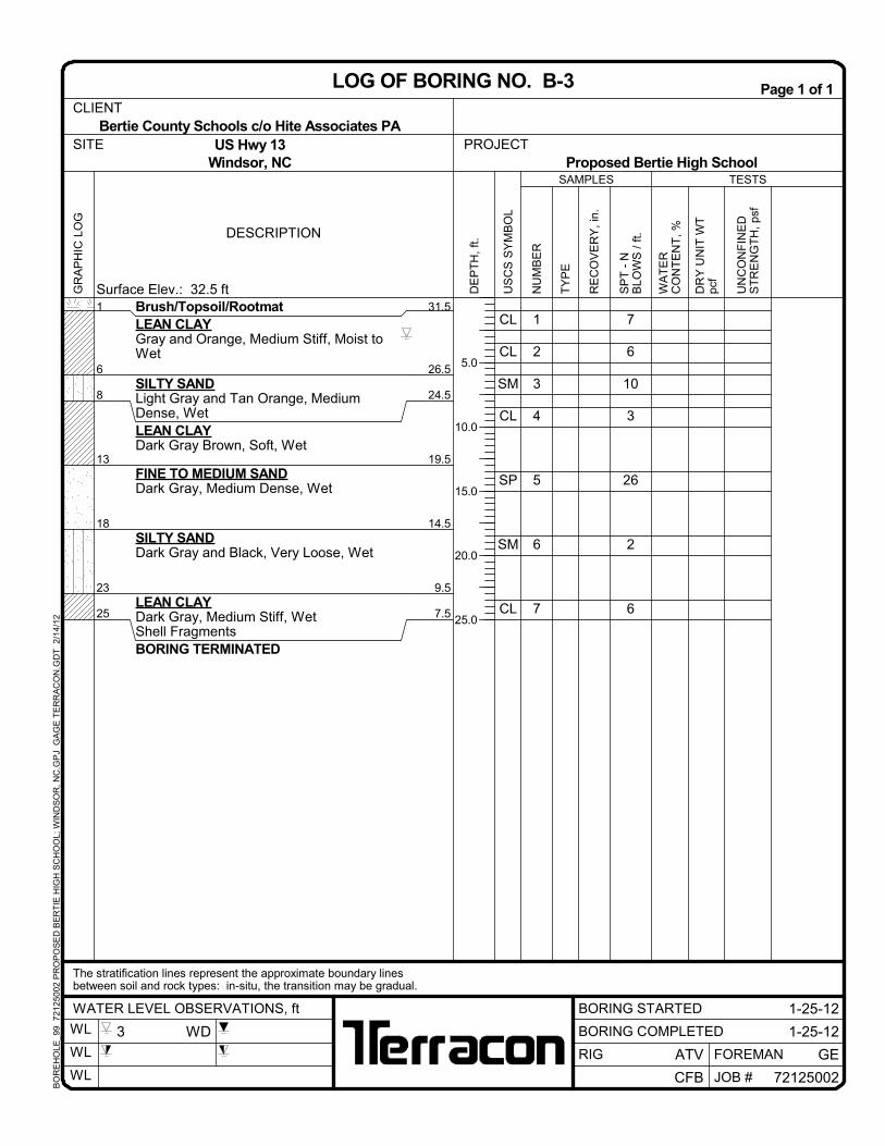
Brush/Topsoil/RootmatLEAN CLAYGray and Orange, Medium Stiff, Moist toWet
SILTY SANDLight Gray and Tan Orange, MediumDense, WetLEAN CLAYDark Gray Brown, Soft, Wet
FINE TO MEDIUM SANDDark Gray, Medium Dense, Wet
SILTY SANDDark Gray and Black, Very Loose, Wet
LEAN CLAYDark Gray, Medium Stiff, WetShell FragmentsBORING TERMINATED
1
6
8
13
18
23
25
31.5
26.5
24.5
19.5
14.5
9.5
7.5
TESTS
DESCRIPTION
UN
CO
NF
INE
DS
TR
EN
GT
H,
psf
Surface Elev.: 32.5 ft
SAMPLES
US
CS
SY
MB
OL
WA
TE
RC
ON
TE
NT
, %
TY
PE
NU
MB
ER
DE
PT
H,
ft.
RE
CO
VE
RY
, in
.
SP
T -
NB
LOW
S /
ft.
DR
Y U
NIT
WT
pcf
5.0
10.0
15.0
20.0
25.0
PROJECT
1-25-12WATER LEVEL OBSERVATIONS, ft
GR
AP
HIC
LO
GPage 1 of 1
BORING COMPLETED
CFB
GEFOREMANRIG
1-25-12
72125002
Bertie County Schools c/o Hite Associates PACLIENT
LOG OF BORING NO. B-3
US Hwy 13Windsor, NC
The stratification lines represent the approximate boundary linesbetween soil and rock types: in-situ, the transition may be gradual.
Proposed Bertie High SchoolSITE
BORING STARTED
ATV
WL
WL
WL JOB #
3 WD
BO
RE
HO
LE_9
9 7
212
5002
PR
OP
OS
ED
BE
RT
IE H
IGH
SC
HO
OL;
WIN
DS
OR
, NC
.GP
J G
AG
E T
ER
RA
CO
N.G
DT
2/
14/1
2
SS
SS
SS
SS
SS
SS
SS
CL
CL
CL
CL
SP
SC
CL
1
2
3
4
5
6
7
7
8
3
4
20
11
10
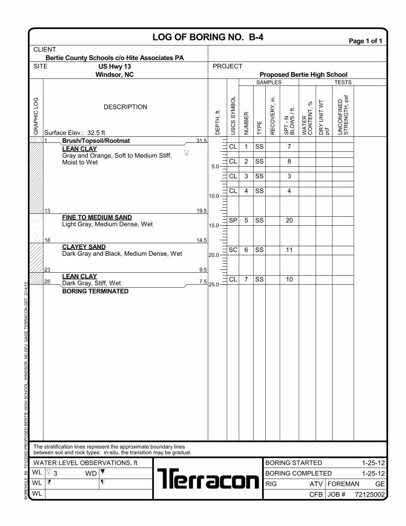
Brush/Topsoil/RootmatLEAN CLAYGray and Orange, Soft to Medium Stiff,Moist to Wet
FINE TO MEDIUM SANDLight Gray, Medium Dense, Wet
CLAYEY SANDDark Gray and Black, Medium Dense, Wet
LEAN CLAYDark Gray, Stiff, WetBORING TERMINATED
1
13
18
23
25
31.5
19.5
14.5
9.5
7.5
TESTS
DESCRIPTION
UN
CO
NF
INE
DS
TR
EN
GT
H,
psf
Surface Elev.: 32.5 ft
SAMPLES
US
CS
SY
MB
OL
WA
TE
RC
ON
TE
NT
, %
TY
PE
NU
MB
ER
DE
PT
H,
ft.
RE
CO
VE
RY
, in
.
SP
T -
NB
LOW
S /
ft.
DR
Y U
NIT
WT
pcf
5.0
10.0
15.0
20.0
25.0
PROJECT
1-25-12WATER LEVEL OBSERVATIONS, ft
GR
AP
HIC
LO
GPage 1 of 1
BORING COMPLETED
CFB
GEFOREMANRIG
1-25-12
72125002
Bertie County Schools c/o Hite Associates PACLIENT
LOG OF BORING NO. B-4
US Hwy 13Windsor, NC
The stratification lines represent the approximate boundary linesbetween soil and rock types: in-situ, the transition may be gradual.
Proposed Bertie High SchoolSITE
BORING STARTED
ATV
WL
WL
WL JOB #
3 WD
BO
RE
HO
LE_9
9 7
212
5002
PR
OP
OS
ED
BE
RT
IE H
IGH
SC
HO
OL;
WIN
DS
OR
, NC
.GP
J G
AG
E T
ER
RA
CO
N.G
DT
2/
14/1
2
SS
SS
SS
SS
SS
SS
SS
SS
SS
SS
SS
SS
CH
CH
CH
CL
SP
SP
SC
CL
SC
SC
CH
CH
1
2
3
4
5
6
7
8
9
10
11
12
6
6
3
9
15
7
3
5
6
5
6
9
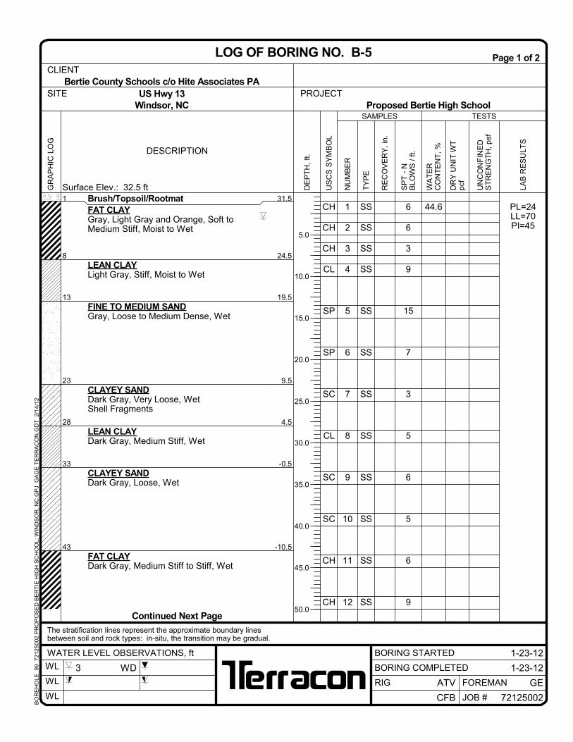
44.6Brush/Topsoil/RootmatFAT CLAYGray, Light Gray and Orange, Soft toMedium Stiff, Moist to Wet
LEAN CLAYLight Gray, Stiff, Moist to Wet
FINE TO MEDIUM SANDGray, Loose to Medium Dense, Wet
CLAYEY SANDDark Gray, Very Loose, WetShell Fragments
LEAN CLAYDark Gray, Medium Stiff, Wet
CLAYEY SANDDark Gray, Loose, Wet
FAT CLAYDark Gray, Medium Stiff to Stiff, Wet
PL=24LL=70PI=45
1
8
13
23
28
33
43
31.5
24.5
19.5
9.5
4.5
-0.5
-10.5
TESTS
DESCRIPTION
UN
CO
NF
INE
DS
TR
EN
GT
H,
psf
Surface Elev.: 32.5 ft
SAMPLES
US
CS
SY
MB
OL
WA
TE
RC
ON
TE
NT
, %
TY
PE
NU
MB
ER
DE
PT
H,
ft.
RE
CO
VE
RY
, in
.
SP
T -
NB
LOW
S /
ft.
DR
Y U
NIT
WT
pcf
5.0
10.0
15.0
20.0
25.0
30.0
35.0
40.0
45.0
50.0Continued Next Page
PROJECT
1-23-12WATER LEVEL OBSERVATIONS, ft
GR
AP
HIC
LO
GPage 1 of 2
BORING COMPLETED
CFB
GEFOREMANRIG
1-23-12
72125002
Bertie County Schools c/o Hite Associates PA
LAB
RE
SU
LTS
CLIENT
LOG OF BORING NO. B-5
US Hwy 13Windsor, NC
The stratification lines represent the approximate boundary linesbetween soil and rock types: in-situ, the transition may be gradual.
Proposed Bertie High SchoolSITE
BORING STARTED
ATV
WL
WL
WL JOB #
3 WD
BO
RE
HO
LE_9
9 7
212
5002
PR
OP
OS
ED
BE
RT
IE H
IGH
SC
HO
OL;
WIN
DS
OR
, NC
.GP
J G
AG
E T
ER
RA
CO
N.G
DT
2/
14/1
2
SS
SS
SS
SS
SS
SS
SS
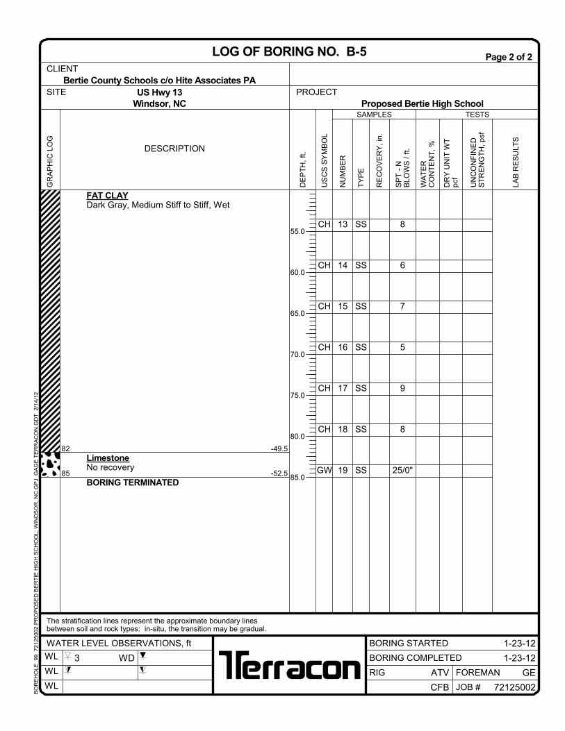
CH
CH
CH
CH
CH
CH
GW
13
14
15
16
17
18
19
8
6
7
5
9
8
25/0"
FAT CLAYDark Gray, Medium Stiff to Stiff, Wet
LimestoneNo recovery
BORING TERMINATED
82
85
-49.5
-52.5
TESTS
DESCRIPTION
UN
CO
NF
INE
DS
TR
EN
GT
H,
psf
SAMPLES
US
CS
SY
MB
OL
WA
TE
RC
ON
TE
NT
, %
TY
PE
NU
MB
ER
DE
PT
H,
ft.
RE
CO
VE
RY
, in
.
SP
T -
NB
LOW
S /
ft.
DR
Y U
NIT
WT
pcf
55.0
60.0
65.0
70.0
75.0
80.0
85.0
PROJECT
1-23-12WATER LEVEL OBSERVATIONS, ft
GR
AP
HIC
LO
GPage 2 of 2
BORING COMPLETED
CFB
GEFOREMANRIG
1-23-12
72125002
Bertie County Schools c/o Hite Associates PA
LAB
RE
SU
LTS
CLIENT
LOG OF BORING NO. B-5
US Hwy 13Windsor, NC
The stratification lines represent the approximate boundary linesbetween soil and rock types: in-situ, the transition may be gradual.
Proposed Bertie High SchoolSITE
BORING STARTED
ATV
WL
WL
WL JOB #
3 WD
BO
RE
HO
LE_9
9 7
212
5002
PR
OP
OS
ED
BE
RT
IE H
IGH
SC
HO
OL;
WIN
DS
OR
, NC
.GP
J G
AG
E T
ER
RA
CO
N.G
DT
2/
14/1
2
SS
SS
SS
SS
SS
SS
SS
CL
CL
SC
SM
SP
SM
CL
1
2
3
4
5
6
7
5
6
13
19
12
8
6
Brush/Topsoil/RootmatLEAN CLAYGray and Orange, Medium Stiff, Moist toWet
CLAYEY SANDLight Gray and Tan Orange, MediumDense, WetSILTY SANDLight Gray, Medium Dense, Wet
FINE TO MEDIUM SANDLight Gray, Medium Dense, Wet
SILTY SANDDark Gray and Black, Loose, Wet
LEAN CLAYDark Gray, Medium Stiff, WetBORING TERMINATED
1
6
8
13
18
23
25
31
26
24
19
14
9
7
TESTS
DESCRIPTION
UN
CO
NF
INE
DS
TR
EN
GT
H,
psf
Surface Elev.: 32 ft
SAMPLES
US
CS
SY
MB
OL
WA
TE
RC
ON
TE
NT
, %
TY
PE
NU
MB
ER
DE
PT
H,
ft.
RE
CO
VE
RY
, in
.
SP
T -
NB
LOW
S /
ft.
DR
Y U
NIT
WT
pcf
5.0
10.0
15.0
20.0
25.0
PROJECT
1-26-12WATER LEVEL OBSERVATIONS, ft
GR
AP
HIC
LO
GPage 1 of 1
BORING COMPLETED
CFB
GEFOREMANRIG
1-26-12
72125002
Bertie County Schools c/o Hite Associates PACLIENT
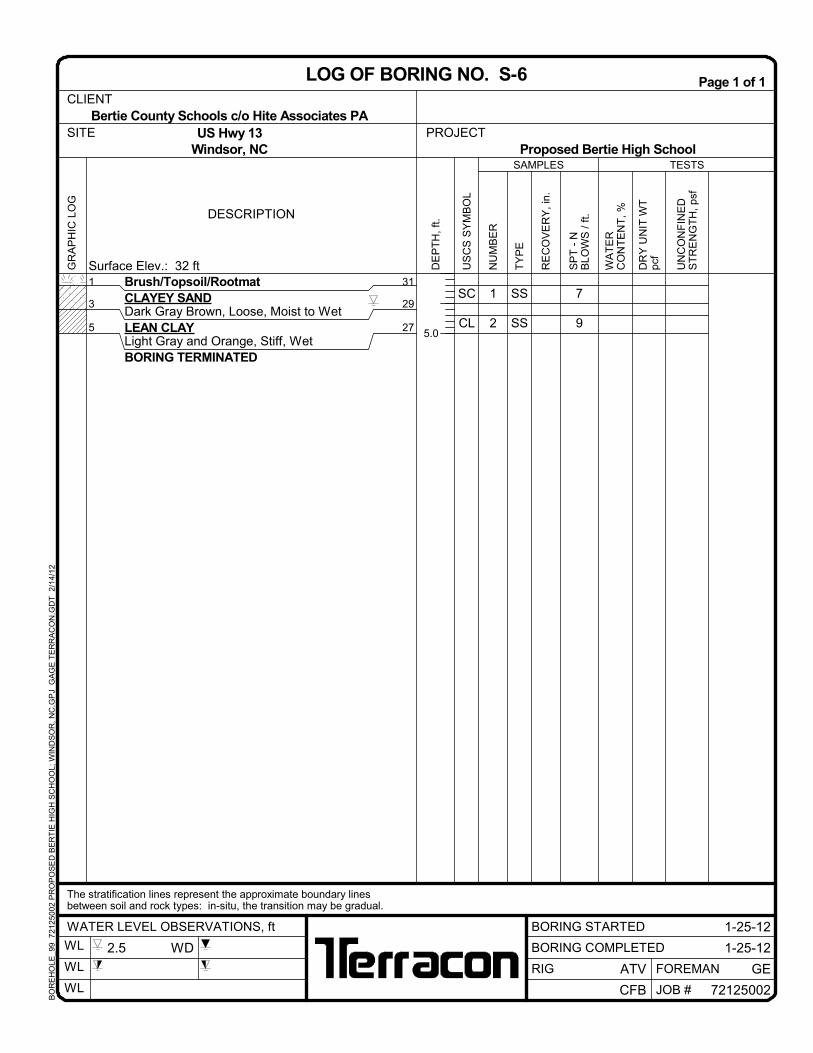
LOG OF BORING NO. B-6
US Hwy 13Windsor, NC
The stratification lines represent the approximate boundary linesbetween soil and rock types: in-situ, the transition may be gradual.
Proposed Bertie High SchoolSITE
BORING STARTED
ATV
WL
WL
WL JOB #
3 WD
BO
RE
HO
LE_9
9 7
212
5002
PR
OP
OS
ED
BE
RT
IE H
IGH
SC
HO
OL;
WIN
DS
OR
, NC
.GP
J G
AG
E T
ER
RA
CO
N.G
DT
2/
14/1
2
SS
SS
SS
SS
SS
SS
SS
CL
CL
SC
SM
SP
SM
CL
1
2
3
4
5
6
7
5
6
9
23
29
10
11
Brush/Topsoil/RootmatLEAN CLAYGray and Orange, Medium Stiff, Moist toWet
CLAYEY SANDLight Gray and Orange, Loose, WetSILTY SANDLight Gray, Medium Dense, Wet
FINE TO MEDIUM SANDLight Gray, Medium Dense, Wet
SILTY SANDDark Gray and Black, Medium Dense, Wet
LEAN CLAYDark Gray, Stiff, WetBORING TERMINATED
1
6
8
13
18
23
25
31
26
24
19
14
9
7
TESTS
DESCRIPTION
UN
CO
NF
INE
DS
TR
EN
GT
H,
psf
Surface Elev.: 32 ft
SAMPLES
US
CS
SY
MB
OL
WA
TE
RC
ON
TE
NT
, %
TY
PE
NU
MB
ER
DE
PT
H,
ft.
RE
CO
VE
RY
, in
.
SP
T -
NB
LOW
S /
ft.
DR
Y U
NIT
WT
pcf
5.0
10.0
15.0
20.0
25.0
PROJECT
1-24-12WATER LEVEL OBSERVATIONS, ft
GR
AP
HIC
LO
GPage 1 of 1
BORING COMPLETED
CFB
GEFOREMANRIG
1-24-12
72125002
Bertie County Schools c/o Hite Associates PACLIENT
LOG OF BORING NO. B-7
US Hwy 13Windsor, NC
The stratification lines represent the approximate boundary linesbetween soil and rock types: in-situ, the transition may be gradual.
Proposed Bertie High SchoolSITE
BORING STARTED
ATV
WL
WL
WL JOB #
2.4 WD
BO
RE
HO
LE_9
9 7
212
5002
PR
OP
OS
ED
BE
RT
IE H
IGH
SC
HO
OL;
WIN
DS
OR
, NC
.GP
J G
AG
E T
ER
RA
CO
N.G
DT
2/
14/1
2
SS
SS
SS
SS
SS
SS
SS
SS
SS
SS
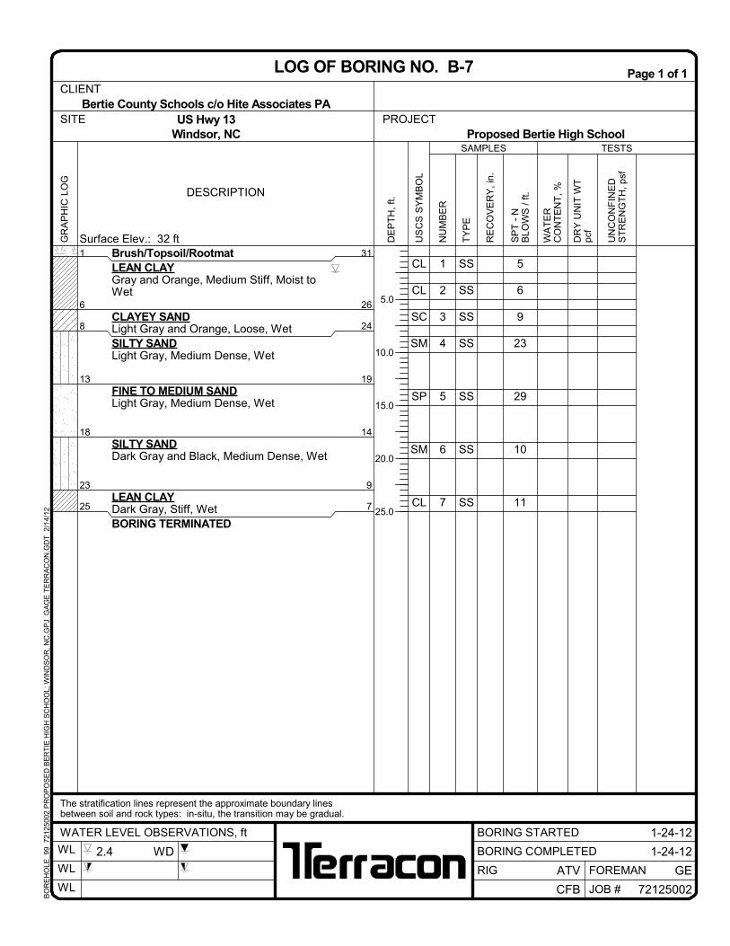
CL
CH
SC
SC
SP
SM
SC
CL
CL
SC
1
2
3
4
5
6
7
8
9
10
6
9
2
11
16
3
6
6
6
5
35.9
Brush/Topsoil/RootmatLEAN CLAYGray and Orange, Medium Stiff, MoistFAT CLAYLight Gray and Orange, Stiff, Moist to WetCLAYEY SANDGray, Very Loose to Medium Dense, Wet
FINE TO MEDIUM SANDGray, Medium Dense, Wet
SILTY SANDDark Gray and Black, Very Loose, Wet
CLAYEY SANDDark Gray, Loose, WetShell Fragments
LEAN CLAYDark Gray, Medium Stiff, Wet
CLAYEY SANDDark Gray, Loose, WetBORING TERMINATED
PL=24,LL=57,PI=33
1
3
6
13
18
23
28
38
40
31
29
26
19
14
9
4
-6
-8
TESTS
DESCRIPTION
UN
CO
NF
INE
DS
TR
EN
GT
H,
psf
Surface Elev.: 32 ft
SAMPLES
US
CS
SY
MB
OL
WA
TE
RC
ON
TE
NT
, %
TY
PE
NU
MB
ER
DE
PT
H,
ft.
RE
CO
VE
RY
, in
.
SP
T -
NB
LOW
S /
ft.
DR
Y U
NIT
WT
pcf
5.0
10.0
15.0
20.0
25.0
30.0
35.0
40.0
PROJECT
1-24-12WATER LEVEL OBSERVATIONS, ft
GR
AP
HIC
LO
GPage 1 of 1
BORING COMPLETED
CFB
GEFOREMANRIG
1-24-12
72125002
Bertie County Schools c/o Hite Associates PA
LAB
RE
SU
LTS
CLIENT
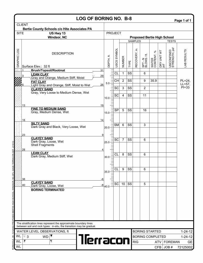
LOG OF BORING NO. B-8
US Hwy 13Windsor, NC
The stratification lines represent the approximate boundary linesbetween soil and rock types: in-situ, the transition may be gradual.
Proposed Bertie High SchoolSITE
BORING STARTED
ATV
WL
WL
WL JOB #
3 WD
BO
RE
HO
LE_9
9 7
212
5002
PR
OP
OS
ED
BE
RT
IE H
IGH
SC
HO
OL;
WIN
DS
OR
, NC
.GP
J G
AG
E T
ER
RA
CO
N.G
DT
2/
14/1
2
SS
SS
SS
SS
SS
SS
SS
CL
CL
CL
CL
SP
SM
SC
1
2
3
4
5
6
7
5
5
4
4
20
1/18
5
Brush/Topsoil/RootmatLEAN CLAYGray, Orange, Red and Dark Gray,Medium Stiff, Moist to Wet
Bertie County Schools c/o Hite Associates PACLIENT
LOG OF BORING NO. B-14
US Hwy 13Windsor, NC
The stratification lines represent the approximate boundary linesbetween soil and rock types: in-situ, the transition may be gradual.
Proposed Bertie High SchoolSITE
BORING STARTED
ATV
WL
WL
WL JOB #
2.6 WD
BO
RE
HO
LE_9
9 7
212
5002
PR
OP
OS
ED
BE
RT
IE H
IGH
SC
HO
OL;
WIN
DS
OR
, NC
.GP
J G
AG
E T
ER
RA
CO
N.G
DT
2/
14/1
2
SS
SS
SS
SS
SS
SS
SS
SS
SS
SS
SS
SS
CL
CH
SC
SC
SC
SC
CL
CL
SC
SC
CH
CH
1
2
3
4
5
6
7
8
9
10
11
12
5
7
5
6
11
2
7
6
4
5
6
7
40.2
Brush/Topsoil/RootmatLEAN CLAYGray and Orange, Medium Stiff, MoistFAT CLAYLight Gray and Orange, Medium Stiff,Moist to WetCLAYEY SANDOrange, Light Gray and Dark Gray, VeryLoose to Medium Dense, Wet
LEAN CLAYDark Gray, Medium Stiff, WetShell Fragments
CLAYEY SANDDark Gray, Loose, Wet
FAT CLAYDark Gray, Medium Stiff to Stiff, Wet
PL=23,LL=61,PI=38
0.5
3
6
23
33
43
31.5
29
26
9
-1
-11
TESTS
DESCRIPTION
UN
CO
NF
INE
DS
TR
EN
GT
H,
psf
Surface Elev.: 32 ft
SAMPLES
US
CS
SY
MB
OL
WA
TE
RC
ON
TE
NT
, %
TY
PE
NU
MB
ER
DE
PT
H,
ft.
RE
CO
VE
RY
, in
.
SP
T -
NB
LOW
S /
ft.
DR
Y U
NIT
WT
pcf
5.0
10.0
15.0
20.0
25.0
30.0
35.0
40.0
45.0
50.0Continued Next Page
PROJECT
1-23-12WATER LEVEL OBSERVATIONS, ft
GR
AP
HIC
LO
GPage 1 of 2
BORING COMPLETED
CFB
GEFOREMANRIG
1-23-12
72125002
Bertie County Schools c/o Hite Associates PA
LAB
RE
SU
LTS
CLIENT
LOG OF BORING NO. B-15
US Hwy 13Windsor, NC
The stratification lines represent the approximate boundary linesbetween soil and rock types: in-situ, the transition may be gradual.
Proposed Bertie High SchoolSITE
BORING STARTED
ATV
WL
WL
WL JOB #
3 WD
BO
RE
HO
LE_9
9 7
212
5002
PR
OP
OS
ED
BE
RT
IE H
IGH
SC
HO
OL;
WIN
DS
OR
, NC
.GP
J G
AG
E T
ER
RA
CO
N.G
DT
2/
14/1
2
SS
SS
SS
SS
SS
SS
SS
CH
CH
CH
CH
CH
SC
GW
13
14
15
16
17
18
19
8
6
8
9
9
3
25/0"
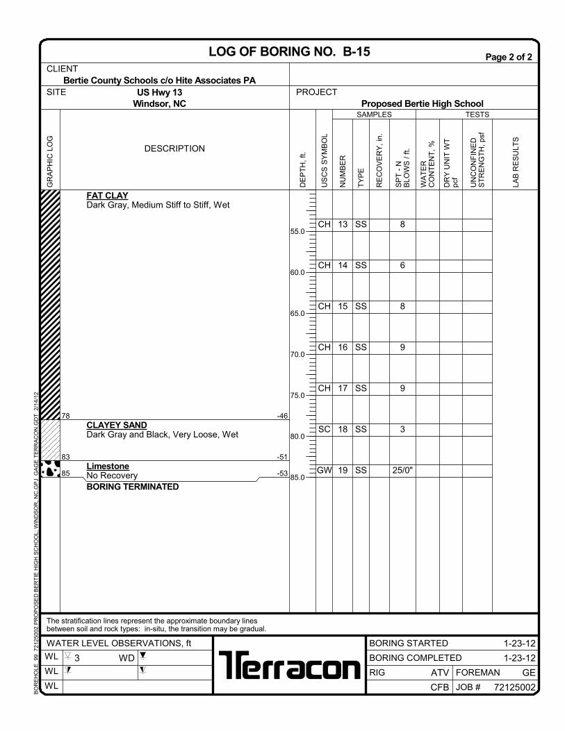
FAT CLAYDark Gray, Medium Stiff to Stiff, Wet
CLAYEY SANDDark Gray and Black, Very Loose, Wet
LimestoneNo RecoveryBORING TERMINATED
78
83
85
-46
-51
-53
TESTS
DESCRIPTION
UN
CO
NF
INE
DS
TR
EN
GT
H,
psf
SAMPLES
US
CS
SY
MB
OL
WA
TE
RC
ON
TE
NT
, %
TY
PE
NU
MB
ER
DE
PT
H,
ft.
RE
CO
VE
RY
, in
.
SP
T -
NB
LOW
S /
ft.
DR
Y U
NIT
WT
pcf
55.0
60.0
65.0
70.0
75.0
80.0
85.0
PROJECT
1-23-12WATER LEVEL OBSERVATIONS, ft
GR
AP
HIC
LO
GPage 2 of 2
BORING COMPLETED
CFB
GEFOREMANRIG
1-23-12
72125002
Bertie County Schools c/o Hite Associates PA
LAB
RE
SU
LTS
CLIENT
LOG OF BORING NO. B-15
US Hwy 13Windsor, NC
The stratification lines represent the approximate boundary linesbetween soil and rock types: in-situ, the transition may be gradual.
Proposed Bertie High SchoolSITE
BORING STARTED
ATV
WL
WL
WL JOB #
3 WD
BO
RE
HO
LE_9
9 7
212
5002
PR
OP
OS
ED
BE
RT
IE H
IGH
SC
HO
OL;
WIN
DS
OR
, NC
.GP
J G
AG
E T
ER
RA
CO
N.G
DT
2/
14/1
2
SS
SS
SS
SS
SS
SS
SS
CL
CL
CL
SC
SC
SC
CL
1
2
3
4
5
6
7
3
8
3
2
28
8
8
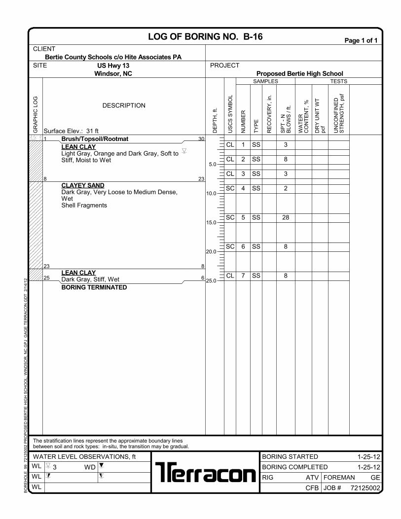
Brush/Topsoil/RootmatLEAN CLAYLight Gray, Orange and Dark Gray, Soft toStiff, Moist to Wet
CLAYEY SANDDark Gray, Very Loose to Medium Dense,WetShell Fragments
LEAN CLAYDark Gray, Stiff, WetBORING TERMINATED
1
8
23
25
30
23
8
6
TESTS
DESCRIPTION
UN
CO
NF
INE
DS
TR
EN
GT
H,
psf
Surface Elev.: 31 ft
SAMPLES
US
CS
SY
MB
OL
WA
TE
RC
ON
TE
NT
, %
TY
PE
NU
MB
ER
DE
PT
H,
ft.
RE
CO
VE
RY
, in
.
SP
T -
NB
LOW
S /
ft.
DR
Y U
NIT
WT
pcf
5.0
10.0
15.0
20.0
25.0
PROJECT
1-25-12WATER LEVEL OBSERVATIONS, ft
GR
AP
HIC
LO
GPage 1 of 1
BORING COMPLETED
CFB
GEFOREMANRIG
1-25-12
72125002
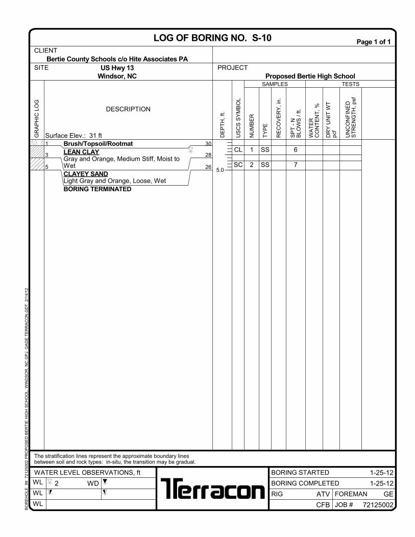
Bertie County Schools c/o Hite Associates PACLIENT
LOG OF BORING NO. B-16
US Hwy 13Windsor, NC
The stratification lines represent the approximate boundary linesbetween soil and rock types: in-situ, the transition may be gradual.
Proposed Bertie High SchoolSITE
BORING STARTED
ATV
WL
WL
WL JOB #
3 WD
BO
RE
HO
LE_9
9 7
212
5002
PR
OP
OS
ED
BE
RT
IE H
IGH
SC
HO
OL;
WIN
DS
OR
, NC
.GP
J G
AG
E T
ER
RA
CO
N.G
DT
2/
14/1
2
SS
SS
SS
SS
SS
SS
SS
CL
CL
CL
SC
SP
SC
CL
1
2
3
4
5
6
7
6
5
4
9
9
4
6
Brush/Topsoil/RootmatLEAN CLAYLight Gray, Orange and Dark Gray,Medium Stiff, Moist to Wet
CLAYEY SANDLight Gray and Orange, Loose, Wet
FINE TO COARSE SANDGray, Loose, Wet
CLAYEY SANDDark Gray, Loose, Wet
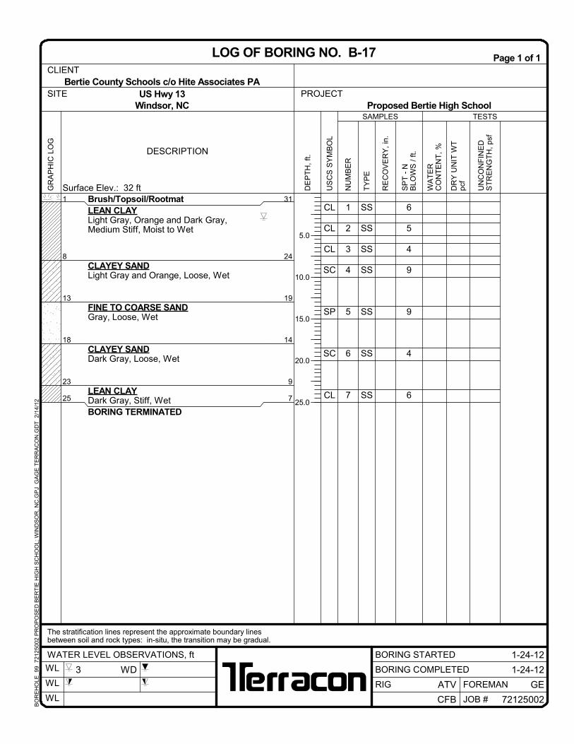
LEAN CLAYDark Gray, Stiff, WetBORING TERMINATED
1
8
13
18
23
25
31
24
19
14
9
7
TESTS
DESCRIPTION
UN
CO
NF
INE
DS
TR
EN
GT
H,
psf
Surface Elev.: 32 ft
SAMPLES
US
CS
SY
MB
OL
WA
TE
RC
ON
TE
NT
, %
TY
PE
NU
MB
ER
DE
PT
H,
ft.
RE
CO
VE
RY
, in
.
SP
T -
NB
LOW
S /
ft.
DR
Y U
NIT
WT
pcf
5.0
10.0
15.0
20.0
25.0
PROJECT
1-24-12WATER LEVEL OBSERVATIONS, ft
GR
AP
HIC
LO
GPage 1 of 1
BORING COMPLETED
CFB
GEFOREMANRIG
1-24-12
72125002
Bertie County Schools c/o Hite Associates PACLIENT
LOG OF BORING NO. B-17
US Hwy 13Windsor, NC
The stratification lines represent the approximate boundary linesbetween soil and rock types: in-situ, the transition may be gradual.
Proposed Bertie High SchoolSITE
BORING STARTED
ATV
WL
WL
WL JOB #
3 WD
BO
RE
HO
LE_9
9 7
212
5002
PR
OP
OS
ED
BE
RT
IE H
IGH
SC
HO
OL;
WIN
DS
OR
, NC
.GP
J G
AG
E T
ER
RA
CO
N.G
DT
2/
14/1
2
SS
SS
SS
SS
SS
SS
CL
CL
CL
CL
SP
SC
1
2
3
4
5
6
6
5
5
3
14
7
Brush/Topsoil/RootmatLEAN CLAYGray and Orange, Soft to Medium Stiff,Moist to Wet
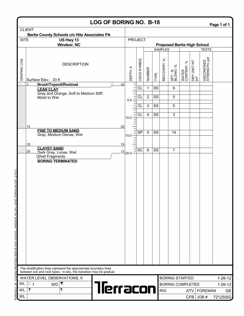
Bertie County Schools c/o Hite Associates PACLIENT
LOG OF BORING NO. B-18
US Hwy 13Windsor, NC
The stratification lines represent the approximate boundary linesbetween soil and rock types: in-situ, the transition may be gradual.
Proposed Bertie High SchoolSITE
BORING STARTED
ATV
WL
WL
WL JOB #
1 WD
BO
RE
HO
LE_9
9 7
212
5002
PR
OP
OS
ED
BE
RT
IE H
IGH
SC
HO
OL;
WIN
DS
OR
, NC
.GP
J G
AG
E T
ER
RA
CO
N.G
DT
2/
14/1
2
SS
SS
SS
SS
SS
SS
CL
CL
CL
CL
SP
SC
1
2
3
4
5
6
6
6
4
4
12
WOH
Brush/Topsoil/RootmatLEAN CLAYGray and Orange, Soft to Medium Stiff,Moist to Wet
FINE TO MEDIUM SANDDark Gray, Medium Dense, Wet
CLAYEY SANDDark Gray, Loose, WetBORING TERMINATED
1
13
18
20
32
20
15
13
TESTS
DESCRIPTION
UN
CO
NF
INE
DS
TR
EN
GT
H,
psf
Surface Elev.: 33 ft
SAMPLES
US
CS
SY
MB
OL
WA
TE
RC
ON
TE
NT
, %
TY
PE
NU
MB
ER
DE
PT
H,
ft.
RE
CO
VE
RY
, in
.
SP
T -
NB
LOW
S /
ft.
DR
Y U
NIT
WT
pcf
5.0
10.0
15.0
20.0
PROJECT
1-24-12WATER LEVEL OBSERVATIONS, ft
GR
AP
HIC
LO
GPage 1 of 1
BORING COMPLETED
CFB
GEFOREMANRIG
1-24-12
72125002
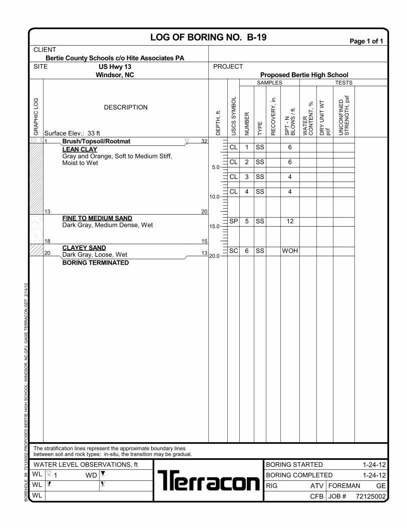
Bertie County Schools c/o Hite Associates PACLIENT
LOG OF BORING NO. B-19
US Hwy 13Windsor, NC
The stratification lines represent the approximate boundary linesbetween soil and rock types: in-situ, the transition may be gradual.
Proposed Bertie High SchoolSITE
BORING STARTED
ATV
WL
WL
WL JOB #
1 WD
BO
RE
HO
LE_9
9 7
212
5002
PR
OP
OS
ED
BE
RT
IE H
IGH
SC
HO
OL;
WIN
DS
OR
, NC
.GP
J G
AG
E T
ER
RA
CO
N.G
DT
2/
14/1
2
SS
SS
CL
CL
1
2
8
10
Brush/Topsoil/RootmatLEAN CLAYDark Gray Brown, Gray and Orange,Medium Stiff to Stiff, Moist to WetBORING TERMINATED
1
5
30
26
TESTS
DESCRIPTION
UN
CO
NF
INE
DS
TR
EN
GT
H,
psf
Surface Elev.: 31 ft
SAMPLES
US
CS
SY
MB
OL
WA
TE
RC
ON
TE
NT
, %
TY
PE
NU
MB
ER
DE
PT
H,
ft.
RE
CO
VE
RY
, in
.
SP
T -
NB
LOW
S /
ft.
DR
Y U
NIT
WT
pcf
5.0
PROJECT
1-24-12WATER LEVEL OBSERVATIONS, ft
GR
AP
HIC
LO
GPage 1 of 1
BORING COMPLETED
CFB
GEFOREMANRIG
1-24-12
72125002
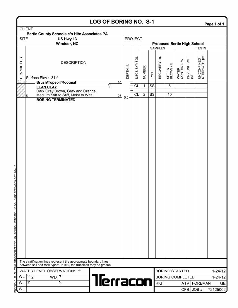
Bertie County Schools c/o Hite Associates PACLIENT
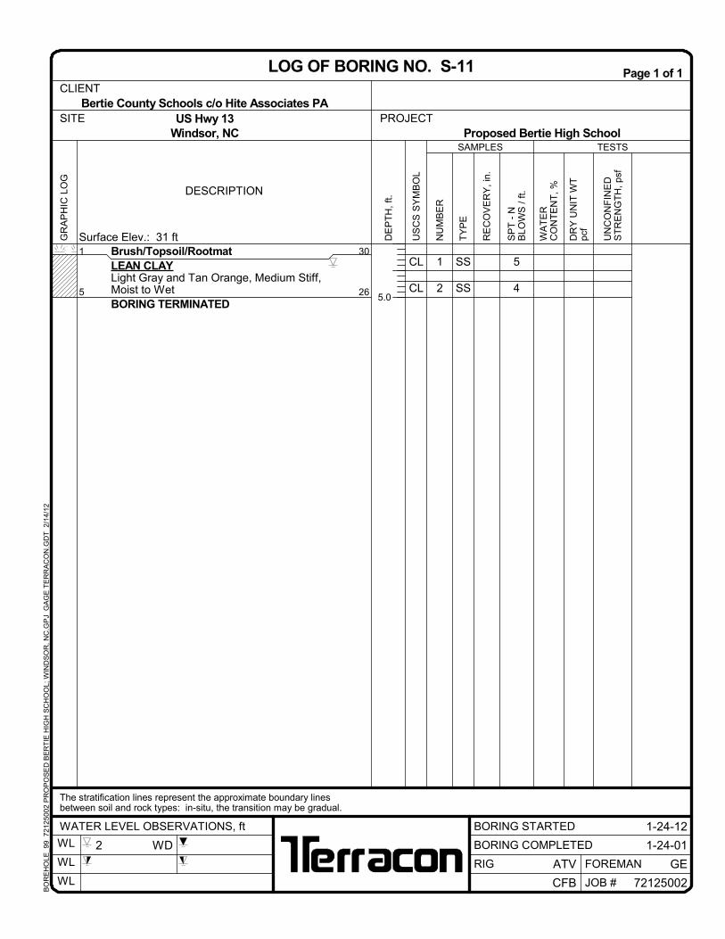
LOG OF BORING NO. S-1
US Hwy 13Windsor, NC
The stratification lines represent the approximate boundary linesbetween soil and rock types: in-situ, the transition may be gradual.
Proposed Bertie High SchoolSITE
BORING STARTED
ATV
WL
WL
WL JOB #
2 WD
BO
RE
HO
LE_9
9 7
212
5002
PR
OP
OS
ED
BE
RT
IE H
IGH
SC
HO
OL;
WIN
DS
OR
, NC
.GP
J G
AG
E T
ER
RA
CO
N.G
DT
2/
14/1
2
SS
SS
CL
CL
1
2
7
5
Brush/Topsoil/RootmatLEAN CLAYDark Gray Brown, Gray and Orange,Medium Stiff, Moist to WetBORING TERMINATED
1
5
29
25
TESTS
DESCRIPTION
UN
CO
NF
INE
DS
TR
EN
GT
H,
psf
Surface Elev.: 30 ft
SAMPLES
US
CS
SY
MB
OL
WA
TE
RC
ON
TE
NT
, %
TY
PE
NU
MB
ER
DE
PT
H,
ft.
RE
CO
VE
RY
, in
.
SP
T -
NB
LOW
S /
ft.
DR
Y U
NIT
WT
pcf
5.0
PROJECT
1-26-12WATER LEVEL OBSERVATIONS, ft
GR
AP
HIC
LO
GPage 1 of 1
BORING COMPLETED
CFB
GEFOREMANRIG
1-26-12
72125002
Bertie County Schools c/o Hite Associates PACLIENT
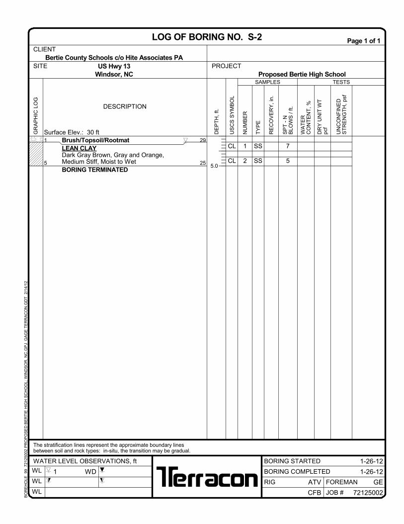
LOG OF BORING NO. S-2
US Hwy 13Windsor, NC
The stratification lines represent the approximate boundary linesbetween soil and rock types: in-situ, the transition may be gradual.
Proposed Bertie High SchoolSITE
BORING STARTED
ATV
WL
WL
WL JOB #
1 WD
BO
RE
HO
LE_9
9 7
212
5002
PR
OP
OS
ED
BE
RT
IE H
IGH
SC
HO
OL;
WIN
DS
OR
, NC
.GP
J G
AG
E T
ER
RA
CO
N.G
DT
2/
14/1
2
SS
SS
CL
CL
1
2
2
5
Brush/Topsoil/RootmatLEAN CLAYGray Brown, Gray and Orange, Soft toMedium Stiff, Moist to WetBORING TERMINATED
1
5
30.5
26.5
TESTS
DESCRIPTION
UN
CO
NF
INE
DS
TR
EN
GT
H,
psf
Surface Elev.: 31.5 ft
SAMPLES
US
CS
SY
MB
OL
WA
TE
RC
ON
TE
NT
, %
TY
PE
NU
MB
ER
DE
PT
H,
ft.
RE
CO
VE
RY
, in
.
SP
T -
NB
LOW
S /
ft.
DR
Y U
NIT
WT
pcf
5.0
PROJECT
1-26-12WATER LEVEL OBSERVATIONS, ft
GR
AP
HIC
LO
GPage 1 of 1
BORING COMPLETED
CFB
GEFOREMANRIG
1-26-12
72125002
Bertie County Schools c/o Hite Associates PACLIENT
LOG OF BORING NO. S-3
US Hwy 13Windsor, NC
The stratification lines represent the approximate boundary linesbetween soil and rock types: in-situ, the transition may be gradual.
Proposed Bertie High SchoolSITE
BORING STARTED
ATV
WL
WL
WL JOB #
2 WD
BO
RE
HO
LE_9
9 7
212
5002
PR
OP
OS
ED
BE
RT
IE H
IGH
SC
HO
OL;
WIN
DS
OR
, NC
.GP
J G
AG
E T
ER
RA
CO
N.G
DT
2/
14/1
2
SS
SS
CL
CL
1
2
4
7
Brush/Topsoil/RootmatLEAN CLAYDark Gray Brown, Gray and Orange, Softto Medium Stiff, Moist to WetBORING TERMINATED
1
5
29
25
TESTS
DESCRIPTION
UN
CO
NF
INE
DS
TR
EN
GT
H,
psf
Surface Elev.: 30 ft
SAMPLES
US
CS
SY
MB
OL
WA
TE
RC
ON
TE
NT
, %
TY
PE
NU
MB
ER
DE
PT
H,
ft.
RE
CO
VE
RY
, in
.
SP
T -
NB
LOW
S /
ft.
DR
Y U
NIT
WT
pcf
5.0
PROJECT
1-26-12WATER LEVEL OBSERVATIONS, ft
GR
AP
HIC
LO
GPage 1 of 1
BORING COMPLETED
CFB
GEFOREMANRIG
1-26-12
72125002
Bertie County Schools c/o Hite Associates PACLIENT
LOG OF BORING NO. S-4
US Hwy 13Windsor, NC
The stratification lines represent the approximate boundary linesbetween soil and rock types: in-situ, the transition may be gradual.
Proposed Bertie High SchoolSITE
BORING STARTED
ATV
WL
WL
WL JOB #
1 WD
BO
RE
HO
LE_9
9 7
212
5002
PR
OP
OS
ED
BE
RT
IE H
IGH
SC
HO
OL;
WIN
DS
OR
, NC
.GP
J G
AG
E T
ER
RA
CO
N.G
DT
2/
14/1
2
SS
SS
CL
CL
1
2
4
4
Brush/Topsoil/RootmatLEAN CLAYGray and Orange, Medium Stiff, Moist toWetBORING TERMINATED
1
5
30
26
TESTS
DESCRIPTION
UN
CO
NF
INE
DS
TR
EN
GT
H,
psf
Surface Elev.: 31 ft
SAMPLES
US
CS
SY
MB
OL
WA
TE
RC
ON
TE
NT
, %
TY
PE
NU
MB
ER
DE
PT
H,
ft.
RE
CO
VE
RY
, in
.
SP
T -
NB
LOW
S /
ft.
DR
Y U
NIT
WT
pcf
5.0
PROJECT
1-24-12WATER LEVEL OBSERVATIONS, ft
GR
AP
HIC
LO
GPage 1 of 1
BORING COMPLETED
CFB
GEFOREMANRIG
1-24-12
72125002
Bertie County Schools c/o Hite Associates PACLIENT
LOG OF BORING NO. S-5
US Hwy 13Windsor, NC
The stratification lines represent the approximate boundary linesbetween soil and rock types: in-situ, the transition may be gradual.
Proposed Bertie High SchoolSITE
BORING STARTED
ATV
WL
WL
WL JOB #
2 WD
BO
RE
HO
LE_9
9 7
212
5002
PR
OP
OS
ED
BE
RT
IE H
IGH
SC
HO
OL;
WIN
DS
OR
, NC
.GP
J G
AG
E T
ER
RA
CO
N.G
DT
2/
14/1
2
SS
SS
SC
CL
1
2
7
9
Brush/Topsoil/RootmatCLAYEY SANDDark Gray Brown, Loose, Moist to WetLEAN CLAYLight Gray and Orange, Stiff, WetBORING TERMINATED
1
3
5
31
29
27
TESTS
DESCRIPTION
UN
CO
NF
INE
DS
TR
EN
GT
H,
psf
Surface Elev.: 32 ft
SAMPLES
US
CS
SY
MB
OL
WA
TE
RC
ON
TE
NT
, %
TY
PE
NU
MB
ER
DE
PT
H,
ft.
RE
CO
VE
RY
, in
.
SP
T -
NB
LOW
S /
ft.
DR
Y U
NIT
WT
pcf
5.0
PROJECT
1-25-12WATER LEVEL OBSERVATIONS, ft
GR
AP
HIC
LO
GPage 1 of 1
BORING COMPLETED
CFB
GEFOREMANRIG
1-25-12
72125002
Bertie County Schools c/o Hite Associates PACLIENT
LOG OF BORING NO. S-6
US Hwy 13Windsor, NC
The stratification lines represent the approximate boundary linesbetween soil and rock types: in-situ, the transition may be gradual.
Proposed Bertie High SchoolSITE
BORING STARTED
ATV
WL
WL
WL JOB #
2.5 WD
BO
RE
HO
LE_9
9 7
212
5002
PR
OP
OS
ED
BE
RT
IE H
IGH
SC
HO
OL;
WIN
DS
OR
, NC
.GP
J G
AG
E T
ER
RA
CO
N.G
DT
2/
14/1
2
SS
SS
CL
CL
1
2
5
5
Brush/Topsoil/RootmatLEAN CLAYGray and Orange, Medium Stiff, Moist toWetBORING TERMINATED
1
5
31
27
TESTS
DESCRIPTION
UN
CO
NF
INE
DS
TR
EN
GT
H,
psf
Surface Elev.: 32 ft
SAMPLES
US
CS
SY
MB
OL
WA
TE
RC
ON
TE
NT
, %
TY
PE
NU
MB
ER
DE
PT
H,
ft.
RE
CO
VE
RY
, in
.
SP
T -
NB
LOW
S /
ft.
DR
Y U
NIT
WT
pcf
5.0
PROJECT
1-25-12WATER LEVEL OBSERVATIONS, ft
GR
AP
HIC
LO
GPage 1 of 1
BORING COMPLETED
CFB
GEFOREMANRIG
1-25-12
72125002
Bertie County Schools c/o Hite Associates PACLIENT
LOG OF BORING NO. S-7
US Hwy 13Windsor, NC
The stratification lines represent the approximate boundary linesbetween soil and rock types: in-situ, the transition may be gradual.
Proposed Bertie High SchoolSITE
BORING STARTED
ATV
WL
WL
WL JOB #
2.5 WD
BO
RE
HO
LE_9
9 7
212
5002
PR
OP
OS
ED
BE
RT
IE H
IGH
SC
HO
OL;
WIN
DS
OR
, NC
.GP
J G
AG
E T
ER
RA
CO
N.G
DT
2/
14/1
2
SS
SS
CL
CL
1
2
4
5
Brush/Topsoil/RootmatLEAN CLAYGray and Orange, Medium Stiff, Moist toWetBORING TERMINATED
1
5
31.5
27.5
TESTS
DESCRIPTION
UN
CO
NF
INE
DS
TR
EN
GT
H,
psf
Surface Elev.: 32.5 ft
SAMPLES
US
CS
SY
MB
OL
WA
TE
RC
ON
TE
NT
, %
TY
PE
NU
MB
ER
DE
PT
H,
ft.
RE
CO
VE
RY
, in
.
SP
T -
NB
LOW
S /
ft.
DR
Y U
NIT
WT
pcf
5.0
PROJECT
1-24-12WATER LEVEL OBSERVATIONS, ft
GR
AP
HIC
LO
GPage 1 of 1
BORING COMPLETED
CFB
GEFOREMANRIG
1-24-12
72125002
Bertie County Schools c/o Hite Associates PACLIENT
LOG OF BORING NO. S-8
US Hwy 13Windsor, NC
The stratification lines represent the approximate boundary linesbetween soil and rock types: in-situ, the transition may be gradual.
Proposed Bertie High SchoolSITE
BORING STARTED
ATV
WL
WL
WL JOB #
2.5 WD
BO
RE
HO
LE_9
9 7
212
5002
PR
OP
OS
ED
BE
RT
IE H
IGH
SC
HO
OL;
WIN
DS
OR
, NC
.GP
J G
AG
E T
ER
RA
CO
N.G
DT
2/
14/1
2
SS
SS
CL
CL
1
2
5
6
Brush/Topsoil/RootmatLEAN CLAYGray, Orange and Red, Medium Stiff, Moistto WetBORING TERMINATED
1
5
31.5
27.5
TESTS
DESCRIPTION
UN
CO
NF
INE
DS
TR
EN
GT
H,
psf
Surface Elev.: 32.5 ft
SAMPLES
US
CS
SY
MB
OL
WA
TE
RC
ON
TE
NT
, %
TY
PE
NU
MB
ER
DE
PT
H,
ft.
RE
CO
VE
RY
, in
.
SP
T -
NB
LOW
S /
ft.
DR
Y U
NIT
WT
pcf
5.0
PROJECT
1-24-12WATER LEVEL OBSERVATIONS, ft
GR
AP
HIC
LO
GPage 1 of 1
BORING COMPLETED
CFB
GEFOREMANRIG
1-24-12
72125002
Bertie County Schools c/o Hite Associates PACLIENT
LOG OF BORING NO. S-9
US Hwy 13Windsor, NC
The stratification lines represent the approximate boundary linesbetween soil and rock types: in-situ, the transition may be gradual.
Proposed Bertie High SchoolSITE
BORING STARTED
ATV
WL
WL
WL JOB #
2 WD
BO
RE
HO
LE_9
9 7
212
5002
PR
OP
OS
ED
BE
RT
IE H
IGH
SC
HO
OL;
WIN
DS
OR
, NC
.GP
J G
AG
E T
ER
RA
CO
N.G
DT
2/
14/1
2
SS
SS
CL
SC
1
2
6
7
Brush/Topsoil/RootmatLEAN CLAYGray and Orange, Medium Stiff, Moist toWetCLAYEY SANDLight Gray and Orange, Loose, WetBORING TERMINATED
1
3
5
30
28
26
TESTS
DESCRIPTION
UN
CO
NF
INE
DS
TR
EN
GT
H,
psf
Surface Elev.: 31 ft
SAMPLES
US
CS
SY
MB
OL
WA
TE
RC
ON
TE
NT
, %
TY
PE
NU
MB
ER
DE
PT
H,
ft.
RE
CO
VE
RY
, in
.
SP
T -
NB
LOW
S /
ft.
DR
Y U
NIT
WT
pcf
5.0
PROJECT
1-25-12WATER LEVEL OBSERVATIONS, ft
GR
AP
HIC
LO
GPage 1 of 1
BORING COMPLETED
CFB
GEFOREMANRIG
1-25-12
72125002
Bertie County Schools c/o Hite Associates PACLIENT
LOG OF BORING NO. S-10
US Hwy 13Windsor, NC
The stratification lines represent the approximate boundary linesbetween soil and rock types: in-situ, the transition may be gradual.
Proposed Bertie High SchoolSITE
BORING STARTED
ATV
WL
WL
WL JOB #
2 WD
BO
RE
HO
LE_9
9 7
212
5002
PR
OP
OS
ED
BE
RT
IE H
IGH
SC
HO
OL;
WIN
DS
OR
, NC
.GP
J G
AG
E T
ER
RA
CO
N.G
DT
2/
14/1
2
SS
SS
CL
CL
1
2
5
4
Brush/Topsoil/RootmatLEAN CLAYLight Gray and Tan Orange, Medium Stiff,Moist to WetBORING TERMINATED
1
5
30
26
TESTS
DESCRIPTION
UN
CO
NF
INE
DS
TR
EN
GT
H,
psf
Surface Elev.: 31 ft
SAMPLES
US
CS
SY
MB
OL
WA
TE
RC
ON
TE
NT
, %
TY
PE
NU
MB
ER
DE
PT
H,
ft.
RE
CO
VE
RY
, in
.
SP
T -
NB
LOW
S /
ft.
DR
Y U
NIT
WT
pcf
5.0
PROJECT
1-24-12WATER LEVEL OBSERVATIONS, ft
GR
AP
HIC
LO
GPage 1 of 1
BORING COMPLETED
CFB
GEFOREMANRIG
1-24-01
72125002
Bertie County Schools c/o Hite Associates PACLIENT
LOG OF BORING NO. S-11
US Hwy 13Windsor, NC
The stratification lines represent the approximate boundary linesbetween soil and rock types: in-situ, the transition may be gradual.
Proposed Bertie High SchoolSITE
BORING STARTED
ATV
WL
WL
WL JOB #
2 WD
BO
RE
HO
LE_9
9 7
212
5002
PR
OP
OS
ED
BE
RT
IE H
IGH
SC
HO
OL;
WIN
DS
OR
, NC
.GP
J G
AG
E T
ER
RA
CO
N.G
DT
2/
14/1
2
SS
SS
CL
CL
1
2
4
6
Brush/Topsoil/RootmatLEAN CLAYDark Gray and Light Gray,Soft to MediumStiff, Moist to WetBORING TERMINATED
1
5
30
26
TESTS
DESCRIPTION
UN
CO
NF
INE
DS
TR
EN
GT
H,
psf
Surface Elev.: 31 ft
SAMPLES
US
CS
SY
MB
OL
WA
TE
RC
ON
TE
NT
, %
TY
PE
NU
MB
ER
DE
PT
H,
ft.
RE
CO
VE
RY
, in
.
SP
T -
NB
LOW
S /
ft.
DR
Y U
NIT
WT
pcf
5.0
PROJECT
1-26-12WATER LEVEL OBSERVATIONS, ft
GR
AP
HIC
LO
GPage 1 of 1
BORING COMPLETED
CFB
GEFOREMANRIG
1-26-12
72125002
Bertie County Schools c/o Hite Associates PACLIENT
LOG OF BORING NO. S-12
US Hwy 13Windsor, NC
The stratification lines represent the approximate boundary linesbetween soil and rock types: in-situ, the transition may be gradual.
Proposed Bertie High SchoolSITE
BORING STARTED
ATV
WL
WL
WL JOB #
2 WD
BO
RE
HO
LE_9
9 7
212
5002
PR
OP
OS
ED
BE
RT
IE H
IGH
SC
HO
OL;
WIN
DS
OR
, NC
.GP
J G
AG
E T
ER
RA
CO
N.G
DT
2/
14/1
2
SS
SS
CL
CL
1
2
6
6
Brush/Topsoil/RootmatLEAN CLAYOrange and Gray, Medium Stiff, MoisttoWetBORING TERMINATED
1
5
30.5
26.5
TESTS
DESCRIPTION
UN
CO
NF
INE
DS
TR
EN
GT
H,
psf
Surface Elev.: 31.5 ft
SAMPLES
US
CS
SY
MB
OL
WA
TE
RC
ON
TE
NT
, %
TY
PE
NU
MB
ER
DE
PT
H,
ft.
RE
CO
VE
RY
, in
.
SP
T -
NB
LOW
S /
ft.
DR
Y U
NIT
WT
pcf
5.0
PROJECT
1-26-12WATER LEVEL OBSERVATIONS, ft
GR
AP
HIC
LO
GPage 1 of 1
BORING COMPLETED
CFB
GEFOREMANRIG
1-26-12
72125002
Bertie County Schools c/o Hite Associates PACLIENT
LOG OF BORING NO. S-13
US Hwy 13Windsor, NC
The stratification lines represent the approximate boundary linesbetween soil and rock types: in-situ, the transition may be gradual.
Proposed Bertie High SchoolSITE
BORING STARTED
ATV
WL
WL
WL JOB #
2 WD
BO
RE
HO
LE_9
9 7
212
5002
PR
OP
OS
ED
BE
RT
IE H
IGH
SC
HO
OL;
WIN
DS
OR
, NC
.GP
J G
AG
E T
ER
RA
CO
N.G
DT
2/
14/1
2
SS
SS
CL
CL
1
2
7
7
Brush/Topsoil/RootmatLEAN CLAYOrange and Gray, Medium Stiff, Moist toWetBORING TERMINATED
1
5
30.5
26.5
TESTS
DESCRIPTION
UN
CO
NF
INE
DS
TR
EN
GT
H,
psf
Surface Elev.: 31.5 ft
SAMPLES
US
CS
SY
MB
OL
WA
TE
RC
ON
TE
NT
, %
TY
PE
NU
MB
ER
DE
PT
H,
ft.
RE
CO
VE
RY
, in
.
SP
T -
NB
LOW
S /
ft.
DR
Y U
NIT
WT
pcf
5.0
PROJECT
1-26-12WATER LEVEL OBSERVATIONS, ft
GR
AP
HIC
LO
GPage 1 of 1
BORING COMPLETED
CFB
GEFOREMANRIG
1-26-12
72125002
Bertie County Schools c/o Hite Associates PACLIENT
LOG OF BORING NO. S-14
US Hwy 13Windsor, NC
The stratification lines represent the approximate boundary linesbetween soil and rock types: in-situ, the transition may be gradual.
Proposed Bertie High SchoolSITE
BORING STARTED
ATV
WL
WL
WL JOB #
1.5 WD
BO
RE
HO
LE_9
9 7
212
5002
PR
OP
OS
ED
BE
RT
IE H
IGH
SC
HO
OL;
WIN
DS
OR
, NC
.GP
J G
AG
E T
ER
RA
CO
N.G
DT
2/
14/1
2
SS
SS
CL
CL
1
2
7
6
Brush/Topsoil/RootmatLEAN CLAYGray, Orange and Red, Medium Stiff, Moistto WetBORING TERMINATED
1
5
30
26
TESTS
DESCRIPTION
UN
CO
NF
INE
DS
TR
EN
GT
H,
psf
Surface Elev.: 31 ft
SAMPLES
US
CS
SY
MB
OL
WA
TE
RC
ON
TE
NT
, %
TY
PE
NU
MB
ER
DE
PT
H,
ft.
RE
CO
VE
RY
, in
.
SP
T -
NB
LOW
S /
ft.
DR
Y U
NIT
WT
pcf
5.0
PROJECT
1-26-12WATER LEVEL OBSERVATIONS, ft
GR
AP
HIC
LO
GPage 1 of 1
BORING COMPLETED
CFB
GEFOREMANRIG
1-26-12
72125002
Bertie County Schools c/o Hite Associates PACLIENT
LOG OF BORING NO. S-15
US Hwy 13Windsor, NC
The stratification lines represent the approximate boundary linesbetween soil and rock types: in-situ, the transition may be gradual.
Proposed Bertie High SchoolSITE
BORING STARTED
ATV
WL
WL
WL JOB #
1.5 WD
BO
RE
HO
LE_9
9 7
212
5002
PR
OP
OS
ED
BE
RT
IE H
IGH
SC
HO
OL;
WIN
DS
OR
, NC
.GP
J G
AG
E T
ER
RA
CO
N.G
DT
2/
14/1
2
Geotechnical Engineering Report Bertie High School ■ Windsor, North Carolina February 20, 2012 ■ Terracon Project No. 72125002
APPENDIX B SUPPORTING DOCUMENTS
Geotechnical Engineering Report Bertie High School ■ Windsor, North Carolina February 20, 2012 ■ Terracon Project No. 72125002
Responsive ■ Resourceful ■ Reliable
Field Exploration Description The boring locations were staked by representative of Terracon using a hand held GPS on the paths cut through the site by the surveyor. Elevations were interpolated from a site plan provided by Hite Associates. The locations and elevations of the borings should be considered accurate only to the degree implied by the means and methods used to define them. The soil test borings were performed by an ATV-mounted power drilling rig utilizing mud rotary drilling procedures to advance the boreholes. The drilling tools were removed from the borehole and representative soil samples were obtained at 2.5 to 5 foot intervals using split-barrel sampling procedures. In the split-barrel sampling procedure, a standard 2-inch outer diameter split-barrel sampling spoon is driven into the ground with a 140-pound hammer falling a distance of 30 inches. A cathead and rope assembly is used to lift the 140 pound hammer. After seating the sampler 6 inches at the bottom of the borehole to penetrate any loose cuttings, the sampler is driven an additional 12 inches. The number of blows required to advance the sampling spoon the last 12 inches is recorded as the standard penetration resistance value (N-value). These N-values are indicated on the boring logs at the depths of occurrence. A field log of each boring was prepared by the drill crew. These logs included visual classifications of the materials encountered during drilling as well as the driller’s interpretation of the subsurface conditions between samples. Final boring logs included with this report represent the engineer's interpretation of the field logs and include modifications based on laboratory observation and tests of the samples. Additional information provided on the boring logs attached to this report includes soil descriptions, consistency evaluations, boring depths, sampling intervals, and groundwater conditions Laboratory Testing Descriptive classifications of the soils indicated on the boring logs are in accordance with the enclosed General Notes and the Unified Soil Classification System. Also shown are estimated Unified Soil Classification Symbols. A brief description of this classification system is attached to this report. Soils laboratory testing was performed under the direction of a geotechnical engineer and included visual classification, moisture content, grain size analysis and Atterberg limits, as appropriate. The results of the laboratory testing are shown on the borings logs and in Appendix A.
Exhibit B-1
GENERAL NOTES
DRILLING & SAMPLING SYMBOLS: SS: Split Spoon - 1-3/8" I.D., 2" O.D., unless otherwise noted HS: Hollow Stem Auger ST: Thin-Walled Tube – 2” O.D., 3" O.D., unless otherwise noted PA: Power Auger (Solid Stem) RS: Ring Sampler - 2.42" I.D., 3" O.D., unless otherwise noted HA: Hand Auger DB: Diamond Bit Coring - 4", N, B RB: Rock Bit BS: Bulk Sample or Auger Sample WB Wash Boring or Mud Rotary
The number of blows required to advance a standard 2-inch O.D. split-spoon sampler (SS) the last 12 inches of the total 18-inch penetration with a 140-pound hammer falling 30 inches is considered the “Standard Penetration” or “N-value”.
WATER LEVEL MEASUREMENT SYMBOLS: WL: Water Level WS: While Sampling BCR: Before Casing Removal WCI: Wet Cave in WD: While Drilling ACR: After Casing Removal DCI: Dry Cave in AB: After Boring N/E: Not Encountered Water levels indicated on the boring logs are the levels measured in the borings at the times indicated. Groundwater levels at other times and other locations across the site could vary. In pervious soils, the indicated levels may reflect the location of groundwater. In low permeability soils, the accurate determination of groundwater levels may not be possible with only short-term observations. DESCRIPTIVE SOIL CLASSIFICATION: Soil classification is based on the Unified Soil Classification System. Coarse Grained Soils have more than 50% of their dry weight retained on a #200 sieve; their principal descriptors are: boulders, cobbles, gravel or sand. Fine Grained Soils have less than 50% of their dry weight retained on a #200 sieve; they are principally described as clays if they are plastic, and silts if they are slightly plastic or non-plastic. Major constituents may be added as modifiers and minor constituents may be added according to the relative proportions based on grain size. In addition to gradation, coarse-grained soils are defined on the basis of their in-place relative density and fine-grained soils on the basis of their consistency.
CONSISTENCY OF FINE-GRAINED SOILS RELATIVE DENSITY OF COARSE-GRAINED SOILS Unconfined
Compressive Strength, Qu, psf
Standard Penetration or N-value (SS)
Blows/Ft. Consistency
Standard Penetration or N-value (SS)
Blows/Ft. Relative Density
< 500 0 – 1 Very Soft 0 – 3 Very Loose 500 – 1,000 2 – 4 Soft 4 – 9 Loose 1,000 – 2,000 4 – 8 Medium Stiff 10 – 29 Medium Dense 2,000 – 4,000 8 – 15 Stiff 30 – 49 Dense 4,000 – 8,000 15 – 30 Very Stiff 50+ Very Dense
8,000+ 30+ Hard
RELATIVE PROPORTIONS OF SAND AND GRAVEL GRAIN SIZE TERMINOLOGY Descriptive Term(s)
of other constituents Percent of Dry Weight
Major Component of Sample
Particle Size
Trace <15 Boulders Over 12 in. (300mm) With 15 – 29 Cobbles 12 in. to 3 in. (300mm to 75mm)
Modifier >29 Gravel 3 in. to #4 sieve (75mm to 4.75mm) Sand #4 to #200 sieve (4.75 to 0.075mm) Silt or Clay Passing #200 Sieve (0.075mm)
RELATIVE PROPORTIONS OF FINES PLASTICITY DESCRIPTION Descriptive Term(s)
of other constituents Percent of Dry Weight Term Plasticity
Index
Trace <5 Non-plastic 0 With 5 – 12 Low 1 – 10
Modifier >12 Medium 11 – 30 High >30
Exhibit B-2
UNIFIED SOIL CLASSIFICATION SYSTEM
Criteria for Assigning Group Symbols and Group Names Using Laboratory TestsA Soil Classification Group
Symbol
Group NameB
Coarse Grained Soils
More than 50% retained
on No. 200 sieve
Gravels More than 50% of coarse fraction retained on No. 4 sieve
Clean Gravels Less than 5% finesC
Cu ≥ 4 and 1 ≤ Cc ≤ 3E GW Well-graded gravelF
Cu < 4 and/or 1 > Cc > 3E GP Poorly graded gravelF
Gravels with Fines More than 12% finesC
Fines classify as ML or MH GM Silty gravelF,G, H
Fines classify as CL or CH GC Clayey gravelF,G,H
Sands 50% or more of coarse fraction passes No. 4 sieve
Clean Sands Less than 5% finesD
Cu ≥ 6 and 1 ≤ Cc ≤ 3E SW Well-graded sandI
Cu < 6 and/or 1 > Cc > 3E SP Poorly graded sandI
Sands with Fines More than 12% finesD
Fines classify as ML or MH SM Silty sandG,H,I
Fines Classify as CL or CH SC Clayey sandG,H,I
Fine-Grained Soils 50% or more passes the No. 200 sieve
Silts and Clays Liquid limit less than 50
inorganic PI > 7 and plots on or above “A” lineJ CL Lean clayK,L,M
PI < 4 or plots below “A” lineJ ML SiltK,L,M
organic Liquid limit - oven dried < 0.75 OL
Organic clayK,L,M,N Liquid limit - not dried Organic siltK,L,M,O
Silts and Clays Liquid limit 50 or more
inorganic PI plots on or above “A” line CH Fat clayK,L,M
PI plots below “A” line MH Elastic SiltK,L,M
organic Liquid limit - oven dried < 0.75 OH
Organic clayK,L,M,P
Liquid limit - not dried Organic siltK,L,M,Q
Highly organic soils Primarily organic matter, dark in color, and organic odor PT Peat
A Based on the material passing the 3-in. (75-mm) sieve B If field sample contained cobbles or boulders, or both, add “with cobbles
or boulders, or both” to group name. C Gravels with 5 to 12% fines require dual symbols: GW-GM well-graded
gravel with silt, GW-GC well-graded gravel with clay, GP-GM poorly graded gravel with silt, GP-GC poorly graded gravel with clay.
D Sands with 5 to 12% fines require dual symbols: SW-SM well-graded sand with silt, SW-SC well-graded sand with clay, SP-SM poorly graded sand with silt, SP-SC poorly graded sand with clay
E Cu = D60/D10 Cc = 6010
230
DxD)(D
F If soil contains ≥ 15% sand, add “with sand” to group name. G If fines classify as CL-ML, use dual symbol GC-GM, or SC-SM.
HIf fines are organic, add “with organic fines” to group name. I If soil contains ≥ 15% gravel, add “with gravel” to group name. J If Atterberg limits plot in shaded area, soil is a CL-ML, silty clay. K If soil contains 15 to 29% plus No. 200, add “with sand” or “with
gravel,” whichever is predominant. L If soil contains ≥ 30% plus No. 200 predominantly sand, add
“sandy” to group name. M If soil contains ≥ 30% plus No. 200, predominantly gravel, add
“gravelly” to group name. N PI ≥ 4 and plots on or above “A” line. O PI < 4 or plots below “A” line. P PI plots on or above “A” line. Q PI plots below “A” line.