Presented at Short Course V on Exploration for Geothermal Resources, organized by UNU-GTP, GDC and KenGen, at Lake Bogoria and Lake Naivasha, Kenya, Oct. 29 – Nov. 19, 2010. 1 GEOTHERMAL TRAINING PROGRAMME Kenya Electricity Generating Co., Ltd. GEOTHERMAL EXPLORATION IN KENYA Peter A. Omenda Geothermal Development Company P.O. Box 100746, Nairobi 0010 KENYA [email protected]ABSTRACT The high temperature geothermal prospects in Kenya are located within and are associated with the development of the Kenya Rift. Kenya Rift is a continental scale volcano-tectonic feature that stretches from northern to southern Africa. Development of the Rift started during the Oligocene (30million years ago) and activity has continued to recent times. The last 2 million years saw the development of large shield volcanoes within the axis of the rift. These centres are the most important geothermal prospects within the rift. Association between rifting and most of the occurrences of geothermal energy is mainly due to shallow magma chambers underneath the young volcanoes within the rift axis. Detailed surface studies of most of the prospects in the central sector of the rift which comprises Suswa, Longonot, Olkaria, Eburru, Menengai, Lakes Bogoria and Baringo, Korosi and Paka volcanic fields have been studies and geothermal systems identified. Electric power is currently being generated at Olkaria with 209MWe installed while exploration drilling has been undertaken at Eburru and a 2.5MWe pilot plant is being developed by KenGen and due to be commissioned by 2011. Production drilling is in progress for 280MWe for Olkaria I unit 4 and Olkaria 4 developments due to be commissioned in 2013. The Geothermal Development Company (GDC) is currently undertaking detailed studies at Silali, Paka, Barrier and Korosi for siting of exploration wells. It is estimated that more than 7,000MWe can be generated from prospects in the Kenya rift. 1. INTRODUCTION Geothermal is an indigenous and abundantly occurring resource in Kenya. Exploitation of Kenya’s geothermal resources has environmental and social advantages over the other major sources of electricity generation options available for the country. Geothermal is the least cost source of electric power for base load in Kenya (Acres, 1987, 1994; 1997; KPLC, 1998, 2000). Currently, 209 MW e of the installed interconnected generation of 1350MW e is generated from geothermal sources at Olkaria. Geothermal is expected to contribute additional 5000MW e by 2030. Current estimates indicate that generation potential of the Kenya Rift could exceed 7,000MW. In order to fast track development of geothermal resources in Kenya, the Government of Kenya incorporated GDC to explore all geothermal resources in the country, drill exploration and production wells and sell steam to power producers.
Transcript
Presented at Short Course V on Exploration for Geothermal Resources, organized by UNU-GTP, GDC and KenGen, at Lake Bogoria and Lake Naivasha, Kenya, Oct. 29 – Nov. 19, 2010.
1
GEOTHERMAL TRAINING PROGRAMME Kenya Electricity Generating Co., Ltd.
The high temperature geothermal prospects in Kenya are located within and are associated with the development of the Kenya Rift. Kenya Rift is a continental scale volcano-tectonic feature that stretches from northern to southern Africa. Development of the Rift started during the Oligocene (30million years ago) and activity has continued to recent times. The last 2 million years saw the development of large shield volcanoes within the axis of the rift. These centres are the most important geothermal prospects within the rift. Association between rifting and most of the occurrences of geothermal energy is mainly due to shallow magma chambers underneath the young volcanoes within the rift axis. Detailed surface studies of most of the prospects in the central sector of the rift which comprises Suswa, Longonot, Olkaria, Eburru, Menengai, Lakes Bogoria and Baringo, Korosi and Paka volcanic fields have been studies and geothermal systems identified. Electric power is currently being generated at Olkaria with 209MWe installed while exploration drilling has been undertaken at Eburru and a 2.5MWe pilot plant is being developed by KenGen and due to be commissioned by 2011. Production drilling is in progress for 280MWe for Olkaria I unit 4 and Olkaria 4 developments due to be commissioned in 2013. The Geothermal Development Company (GDC) is currently undertaking detailed studies at Silali, Paka, Barrier and Korosi for siting of exploration wells. It is estimated that more than 7,000MWe can be generated from prospects in the Kenya rift.
1. INTRODUCTION Geothermal is an indigenous and abundantly occurring resource in Kenya. Exploitation of Kenya’s geothermal resources has environmental and social advantages over the other major sources of electricity generation options available for the country. Geothermal is the least cost source of electric power for base load in Kenya (Acres, 1987, 1994; 1997; KPLC, 1998, 2000). Currently, 209 MWe of the installed interconnected generation of 1350MWe is generated from geothermal sources at Olkaria. Geothermal is expected to contribute additional 5000MWe by 2030. Current estimates indicate that generation potential of the Kenya Rift could exceed 7,000MW. In order to fast track development of geothermal resources in Kenya, the Government of Kenya incorporated GDC to explore all geothermal resources in the country, drill exploration and production wells and sell steam to power producers.
Omenda 2 Geothermal exploration in Kenya
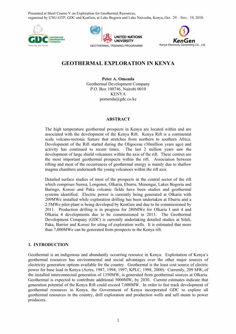
2. GEOLOGICAL SETTING Kenya rift is part of the eastern arm of the East African rift system. The segment referred to as the Kenya rift extends from Lake Turkana in the north to northern Tanzania near Lake Natron (Figure 1). In this sector of the rift system, the activity began about 30 million years ago in the Lake Turkana area and then migrated southward being more intense about 14 million years ago. Formation of the graben structure started about 5million years ago and was followed by fissure eruptions in the axis of the rift to form flood lavas by about 2 to 1 million years ago. During the last 2 million years ago, volcanic activities became more intense within the axis of the rift. During this time, large shield volcanoes, most of which are geothermal prospects, developed in the axis of the rift. The volcanoes include Suswa, Longonot, Olkaria, Eburru, Menengai, Korosi, Paka, Silali, Emuruangogolak, and Barrier Complex.
3. GEOTHERMAL DEVELOPMENT Exploration for geothermal energy in Kenya started in the 1960’s with surface exploration that culminated in two geothermal wells being drilled at Olkaria. In early 1970’s more geological and geophysical work was carried out between Lake Bogoria and Olkaria. This survey identified several areas suitable for geothermal prospecting and by 1973, drilling of deep exploratory wells commenced and was funded by UNDP. Additional wells were thereafter, drilled to prove enough steam for the generation of electricity and in June 1981, the first 15 MWe generating unit was commissioned. The second 15 MWe unit was commissioned in November 1982 and the third unit in March 1985 which increased the total generation to 45 MWe. This was the first geothermal power station in Africa and is owned and operated by KenGen. GDC is currently undertaking production drilling in the field to support an additional 140MWe plant being developed by KenGen for commissioning in 2013. In 2003, KenGen commissioned a 70MWe Olkaria II power plant in the Northeast field and was further increased by 35MW in 2010 giving the station an installed capacity of 105MWe. In the western sector of the greater Olkaria field is 55MWe Orpower4 plant. The generator is currently undertaking production drilling to support a further 36MWe in the field. GDC is also drilling production wells in the Olkaria IV area earmarked for 140MWe plant being developed by KenGen. The plant is planned for commissioning in 2013. All the developments at Olkaria will result in a total installed capacity of 525MW by 2013 against a proven geothermal resource potential of well over 1,000MWe. The Government of Kenya and other parties have continued to explore for geothermal energy in the Kenya rift. British Geological Survey and the government of Kenya carried out studies in the Lake Magadi area (Allen at al., 1992), the area around Lake Naivasha including Longonot, Olkaria, Eburru, and Badlands (Clarke et al., 1990), and in the north rift (Dunkley et al., 1993). Geotermica Italiana also did some work in Longonot and Suswa calderas and also described geo-volcanological features important in geothermal exploration at Menengai (Geotermica Italiana Srl, 1987a, 1987b, and 1988).
FIGURE 1: Map of the Kenya Rift showing the geothermal prospects
Geothermal exploration in Kenya 3 Omenda
4. GEOTHERMAL PROSPECTS 4.1 Eburru Eburru volcanic complex is located to the north of Olkaria. The Government of Kenya carried out detailed surface studies between 1987-1990 that culminated in the drilling of six exploration wells in Eburru between 1989 and 1991. Further infill MT surveys done in 2006 revealed that the Eburru field can support up to 50-60MWe (Wameyo, 2006; Figure 3). The results from the exploration wells indicate that the field had experienced temperatures of over 300oC possibly due to localized intrusive. Discharge fluid chemistry from the wells indicates that the reservoir is non-boiling with moderate salinity brine and a high amount of non condensable gases (NCG). Despite the almost similar geology, the chloride level of EW-I (956 to 1976 ppm) is higher than the Olkaria average. As compared to Olkaria, the reservoir permeability is low (KPC, 1990).
The maximum discharge temperature was 285oC and the total output from the two wells that discharged (EW-1 & EW-6) is 29 MWt (Ofwona, 1996). The estimated power potential of the field based on the data from the wells is about 50-60 MWe (Wameyo, 2006; Mburu, 2006; Omenda et al., 2000) and conceptualized as in Figure 4. The area has a fairly well
established infrastructure and for this reason a 2.5 MWe binary pilot plant is planned for commissioning in 2011.
FIGURE 2: Geological map of Eburru Geothermal Field (Omenda and Karingithi, 1993)
191 192 193 194 195 196 197 198 199
Easting (km)
9926
9927
9928
9929
9930
9931
9932
9933
Nor
tho
ings
(km
)
EW-01EW-02
EW-03
EW-04
EW-05 EW-06
0
5
8
10
15
18
20
25
30
35
80
95
100
150
242
289
360
451
579
Cedar Hill
Lion Hill
Eburru FarmEburruPeak
- m
Legend
Volcanic centre
Geothermal well
Crater
Road Fault
Iso-therm lines80
FIGURE 3: MT Resistivity distribution at 500 m.a.s.l. (Wameyo, 2006)
Omenda 4 Geothermal exploration in Kenya
4.2 Menengai volcano Menengai is a major Quaternary caldera volcano located within the axis of the central segment of the Kenya Rift. The volcano is located within an area characterized by a complex tectonic activity characterized by confluence of two tectono-volcanic axes (Molo and the Solai). The volcano has been active since about 0.8 Ma to present. The volcano is built of Trachyte lavas and associated intermediate pyroclastics. Most of the pyroclastics activity accompanied caldera collapse. Post caldera activity (<0.1 Ma) mainly centred on the caldera floor with eruption of thick piles of trachyte lavas from various centres (Figure 5). MT resistivity distribution at 2km bsl shows a conductive body of less than 5ohm-m centred in the western caldera floor “lobe” and a smaller anomaly at the centre of the caldera (Figure 6). Seismology indicates seismic wave attenuation at 7-8km depths underneath Menengai caldera and Ol’banita,
respectively suggesting the presence of magma bodies, which could be heat sources. Vp/Vs ratios of 1.6-1.7 suggest steam-dominated reservoir (Simiyu, 2003). Gravity modeling also shows the presence of dense bodies at about 4 km depth under the caldera floor. Heat loss survey indicates that the prospect loses about 3,536 MWt naturally to the atmosphere with 2440 MWt being the convective component (Ofwona, 2004). Fumaroles are scarce in the prospect with the few strong ones occurring within the caldera floor. Fumaroles steam compositions have low contents of reactive gases (CO2, H2S, H2, CH4, and N2). Gas geothermometry based on H2S and CO2 indicates that the reservoir temperatures are greater than 250oC. The mapped potential area in Menengai is about 84 Km2 translating to over 1650 MWe of electric power when conversion rate of 15MW per square kilometer is used (Figure 6 and 7). The reservoir rocks are expected to be trachyte as at Olkaria and therefore comparable permeability is postulated. Whereas Olkaria system has several discrete hot magmatic intrusions which are considered heat sources, Menengai has a centralized body under the caldera (Figure 7).
FIGURE 4: Conceptual model of the Eburru Geothermal system (Omenda and Karingithi, 1993)
FIGURE 5: Geological map of Menengai caldera volcano
Geothermal exploration in Kenya 5 Omenda
Environmental baseline studies conducted indicate that minimal impacts would occur from proposed drilling activities and future development of the resource (Mungania et al, 2004). Existing infrastructure also favor development of this resource. If developed, the resulting hot water could be used by the various Agro based industries which are close to the resource in Nakuru town. GDC plans to undertake drilling of exploratory wells in Menengai in February 2011. 4.3 Longonot volcano Longonot is a large caldera volcano within the floor of the southern Kenya Rift adjacent to Olkaria Geothermal field (Figure 1). The volcano comprises of a large trachyte caldera of about 11 km dia and a resurgent activity on the caldera floor that formed a central volcano with a crater at the summit. The caldera floor is filled, to a large extent, by trachytic ashes from the central volcano. The youngest activity (<300 yrs BP) at Longonot was of mixed Trachyte-basalt composition and erupted within the crater floor and on the northern flank of the central volcano (Figure 8). Geothermal surface manifestations are mainly fumaroles and hot grounds within the central crater. The geochemical survey revealed high radon and CO2 gas discharges. Gas geothermometry also indicate that geothermal reservoir temperatures could exceed 300 oC (KenGen, 1998). MT resistivity distribution at 2km bsl shows a conductive body of <11ohm m in the southern slopes of the young central volcano and extending beyond the caldera boundary. It is postulated that the body could be of magmatic type and thus possibly the resource heat source (Figure 9). Preliminary results of micro seismic investigations show correspondence between seismics and MT. Shear wave splitting anisotropy directions were evidenced in the data suggesting fault control in the movement of pressurized fluids in the near subsurface (Onacha, 2006).
FIGURE 6: MT resistivity plot of Menengai at sea level
FIGURE 7: Geothermal model of Menengai volcano
FIGURE 8: Geological map of Longonot Geothermal area
Omenda 6 Geothermal exploration in Kenya
Combined MT, gravity and seismics indicate that the heat source is at 6 km deep with the shallowest portion directly under the central volcano. Conceptual model indicates that the main upflow for the system is to the immediate south of the central crater extending beyond the SE margin of the caldera wall. The fluid then outflows southward (Figure 10). Recharge for the system is probably from the rift shoulders and also axially. The heat source for the main system is associated with the resurgent activity, which developed the central shield volcano within the caldera. The model indicates that a high temperature geothermal system >250oC is expected to exist under Longonot. The prospect has been licensed to Africa Geothermal Investment Limited (AGIL) which intends to undertake exploratory drilling in 2011. 4.4 Suswa Suswa is the southernmost of a series of Quaternary caldera volcanoes in the Kenya rift. The volcano has two nested calderas: outer and inner with diameters of 10 and 4 km, respectively (Figure 11). Volcanism at Suswa that comprised
trachytes and phonolites started about late Pleistocene and continued to less than 1,000 years ago (Omenda, 1997).
Results from detailed surface studies suggest reservoir temperatures of 250oC based on gas geothermometry. Seismic and gravity studies show that the heat source under the caldera is at about 6-8 km deep with a NE-SW bias. Resistivity (MT) at 500 mbsl indicates a low (15-20 ohm m) anomaly under the island block and extending to the north out of the inner caldera (Figure 12).
Conceptual model indicates that heat source for Suswa is a magmatic body centred under Ol Doinyo Nyoke volcano (Figure 13). The body is at a depth of more than 6-8 km and could be the heat source of the geothermal system. The geothermal system must have attained temperatures of more than 250oC as seen from the presence of hydrothermal epidote within the lithics. Gas geothermometry indicate that gases sampled in the prospect originated from sources having temperatures of more than 250oC. The prospect has a fairly good recharge from both the west and east rift escarpments. However, the water table in the rift floor is deep, probably more than 300 m, due to intense faulting of the pre-Suswa formations. The prospect is licensed to WalAm, Inc of Canada. However, it is not clear when the concessionaire may undertake exploratory drilling in the prospect.
FIGURE 9: MT resistivity map of Longonot (Onacha, 2006)
FIGURE 10: 2-D Resistivity model of Longonot Volcano
Geothermal exploration in Kenya 7 Omenda
FIGURE 13: Geothermal model of Suswa volcano 4.5 Lake bBogoria and Arus Arus – Lake Bogoria prospect is the area surrounding Lake Bogoria and extending about 50 km southward and westward (Figure 1). The upper Plio-Pleistocene volcanism of the rift floor in the area between Arus and Lake Bogoria is characterized by large volumes of evolved lavas that consist mostly of peralkaline trachyte, trachyphonolite and phonolite (Figure 14). Small outcrops of basaltic lavas
FIGURE 11: Geological map of Suswa volcano
Ohm/m
200 205 210 215 220
9865
9870
9875
9880
9885
9890
susmt01
susmt02
susmt03
susmt04
susmt05
susmt06
susmt08susmt09susmt17
susmt19
susmt20a
susmt21
susmt25
susmt26
susmt28
susmt30
susmt31
susmt33
susmt34
susmt38
susmt35
10
40
70
100
130
160
190
FIGURE 12: MT plot for Suswa at 500 mbsl
Omenda 8 Geothermal exploration in Kenya
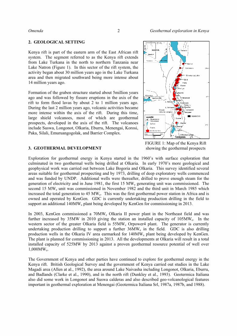
occur in isolated areas within the prospect. The northern sector south of Lake Baringo is, however, dominated by fluvial and alluvial deposits. There are no Quaternary central volcanoes in the prospect.
The geothermal manifestations occurring in the prospect include fumaroles, hot and steaming grounds, anomalous boreholes, hot springs, steam jets, altered grounds, sulphur, calcite and travertine deposits. Most o these manifestations occur along the shores of Lake Bogoria and at the Arus springs (Figure 15). Fluid geothermometry indicates intermediate subsurface temperatures of more than 145-245oC for the Lake Bogoria springs while those at Arus are at 170-192oC. The low resistivity bodies (< 10 ohm-meter) occur mainly along and at the intersection of major faults and transverse zones (Figure 16). These intersection zones may be forming weak regions through which magmatic materials find their way to the shallow sub-surface. However, the resistivity data has not defined clear geothermal reservoirs in the field and more MT stations are planned by GDC in 2011. The geothermal reservoirs in this field, therefore, could be assumed to follow the fault plane model where discrete small reservoirs are located along fault zones (Figure 17).
FIGURE 14: Geological map of the Lake Bogoria – Arus prospect
FIGURE 15: Locations of fumaroles and hot springs in the Lake Bogoria area
Geothermal exploration in Kenya 9 Omenda
4.6 Lake Baringo Lake Baringo geothermal prospect is in the northern part of the Kenyan rift and covers the area around Lake Baringo. Surface manifestations include fumaroles, hot springs, thermally altered hot grounds and anomalous ground water boreholes. The geology of the area is characterized by trachyte and trachy-phonolite to the east and west while basalts occur to the north and alluvial deposits to the south. Olkokwe Island in Lake Baringo is the only Quaternary volcanic complex which is associated with volcanic activity at Korosi to the north Fumaroles and hot springs occur on Olkokwe Island while weak fumarolic areas occur in the western zone along fractures/faults. Gas geothermometry indicates reservoir temperatures of more than 120-200oC in the west near Chepkoiyo well and more than 170oC in the Olkokwe Island system. Resistivity indicates potential occurrences of fault controlled, discrete reservoirs in areas west of the Lake, SE and north (Figure 18). Since a large portion of the prospect is not associated with a centralized Quaternary volcano, it is postulated that the heat sources are probably deep dike swarms along the faults. It can be concluded from the available information that the resource at Lake Baringo is low to intermediate temperature suitable for direct uses.
FIGURE 17: Regional geothermal model of Arus-Bogoria geothermal prospect
! !
!
!
!
!
!
!
!
!
!
!
!!
!
!
! !
! !
!
!
! Endao
Loruk
RUGUS
KECHI
LORUK
Ngambo
Napiyet
Lemuyet
Salabani
Nosuguro
Komolion
KOKWOMOW
Loiminange
NAKURATABEM
KOKWA ISLAND
Lesukut Island
Lekoros Island
Rongena Island
Parmalok Island
KAMPI YA SAMAKI
Longicharo Island
165000 .000000
165000 .000000
170000 .000000
170000 .000000
175000 .000000
175000 .000000
180000 .000000
180000 .000000 0 6 3 Kilomet
Legend Contours Roads
Gulleys Lakes
Prepared & Printed at: GIS-Lab
Olkaria, Naivasha
5
12
20
30
50
Ohm-
Chepkoiyo well
FIGURE 18: Resistivity at sea level at
Lake Baringo prospect
150 155 160 165 170 175 180 185 190
Eastings (km)
0
5
10
15
20
25
30
35
40
45
50
55
No
rth
ing
s (k
m n
ort
h o
f e
qu
ato
r)
Marigat
Lake Bogoria
Arus
Solai basin
Goimet Volcano 0
2
8
15
21
30
46
90
139
196
289
450
Hot springs
MT locations
Fault
Transverse fault
Ohm-m
FIGURE 16: Arus-Bogoria MT resistivity distribution at 2,000 mbsl
Omenda 10 Geothermal exploration in Kenya
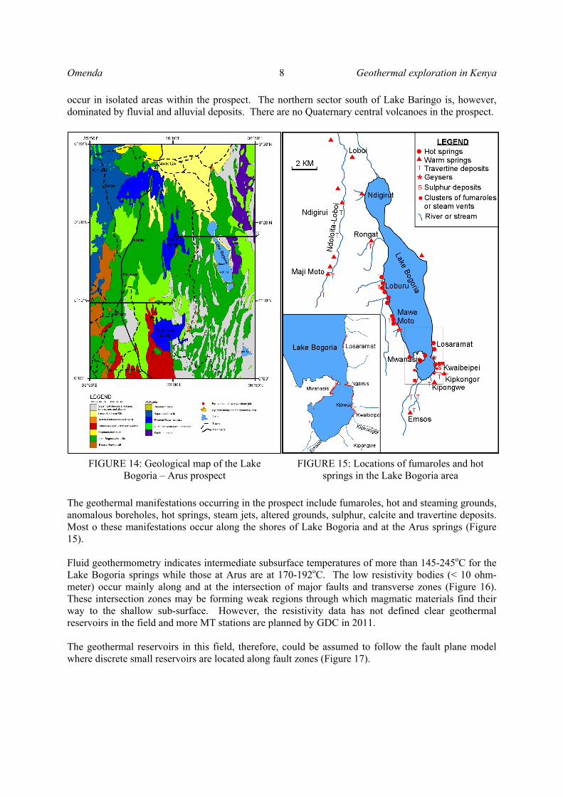
4.7 Korosi volcano Korosi volcano is located in the north rift Valley and neighbours Lake Baringo to the south and Paka volcano to the north. KenGen and the Ministry of Energy undertook detailed surface studies in the prospect in 2005. The area is strongly faulted by a system of NNE trending faults, which extends northwards onto the flanks of Paka volcano (Figure 19). The latest volcanic activity associated with Korosi was of basaltic composition and occurred a few hundred years ago while the last trachytic volcanism occurred about 100ka. Surface geothermal manifestations include hot steaming grounds and fumaroles. Surface temperatures ranging between 90 – 95oC have been recorded. The MT resistivity map at 1500 mbsl shows low resistivity below the Korosi massif but is well defined in resistivity map at 4000 mbsl (Figure 20). The MT plot shows a well defined <10Ωm low resistivity below the Korosi Massif. The low resistivity below the massif is interpreted to mark the top of the heat source for the geothermal system. Gas chemistry of five samples from Korosi using H2S Gas geothermometry function indicates that temperatures of more than 250oC exist in the reservoir under the volcano. Conceptual model indicates that a viable geothermal system exists under the Korosi massif with the upflow within the micro-graben and outflow largely to the north. 4.8 Chepchuk volcanic field The Chepchuk area was covered during the studies at Korosi which was done by KenGen and the Ministry of Energy in year 2005. The geology of Chepchuk is characterized by faulted Plio Pleistocene flood trachytes and younger basaltic flows occupying micro-grabens. The area is
heavily faulted with half of the Chepchuk volcanic complex down faulted westward. It is postulated that the old Chepchuk volcano could be the dominant source but with contribution from Paka volcanic area. It is estimated that the resource is of intermediate temperature.
FIGURE 19: Geological map of Korosi volcano
3
5
5
10
10
10
10
15
15
15
20
20
20
20
20
25
25
25
25
25 25
30
30
30
30
30 30
30
40
40
40
40 40
40
50
50
50
50
50
50
70
70
70
70
70
100
100
100
100
150
150
150
150
200
200
200
300
300
300
500 700
1000
165000 170000 175000 180000 185000 190000 195000
165000 170000 175000 180000 185000 190000 195000
100000
95000
90000
85000
80000
100000
95000
90000
85000
80000
Koro
si Massif
Korosi
KorosiMT
Resistivity at 4000mbsl
Resitivity Based on 1 D interpretation
MT Sounding
TDEM Sounding
2000150010007005003002001501007050403025201510532
ohm.m
Scale 1:250000
m
0 5000 10000 15000
FIGURE 20: Resistivity distributions at 4000 mbsl in Korosi area
Geothermal exploration in Kenya 11 Omenda
4.9 Paka volcano Detailed surface studies of Paka volcano was undertaken in 2006/7. Paka shield volcano is constructed largely by trachyte lavas and pyroclastic deposits and located just to the north of Korosi volcanic complex (Figure 21). Volcanic activity commenced by 390 ka (Trachytes) and continued to within 10 ka (basalts). The structure of Paka is dominated by a broad zone of normal faulting 7.5 km wide graben bound by the eastern and the western fault boundaries respectively. This zone shows a right stepping en echelon arrangement along the volcano and forms one of the regional fault pattern, which extends southwards to Chepchuk and northwards into the southern flanks of Silali. Surface geothermal activity is widely developed at Paka particularly within the summit craters and the northern
flanks where fumaroles at >97oC are common. Sulphur crystals are common for the fumaroles within the craters. Gas geothermometry of fluids from Paka indicate the reservoir system to be at more than 250oC. MT resistivity at Paka prospect shows conductive bodies under the massif and on the eastern side at foot of fault scarp. The latter is not considered to be of geothermal interest (Figure 22).
The anomaly under Paka volcano could be imaging hot rocks. Seismic studies indicate shallow events directly under Paka suggesting that a hot body exists below about 2.5 – 5km depth. Heat loss studies of Paka volcano revealed that a total heat loss of 2,855 MWt occurs within the prospect with a convective
FIGURE 21: Geological map of Paka volcano
180 182 184 186 188 190 192 194 196
Eastings (km)
92
94
96
98
100
102
104
106
108
110
112
114
No
rth
ing
s (k
m)
13456781012141619232732384654647690150200250
Fault line
Road
Volcanic centre
MT sounding
Paka massive
Paka crater
Ohm-m
FIGURE 22: MT resistivity plot at 3000 mbsl
Omenda 12 Geothermal exploration in Kenya
component of 10 MWt. Most of the heat is lost within the Paka craters area. Conceptual model developed for Paka indicates that the system is closely associated with the magmatic intrusion under the volcano. The model indicates that the low resistivity imaged by MT at the foot of the eastern scarps may not be of geothermal significance but further studies are required to characterize the anomaly. GDC plans to collect additional MT data in 2011 to assist in siting of exploration wells. 4.10 Silali volcano Silali is the largest Quaternary caldera volcano on the floor of the northern Kenya rift. Previous studies of the volcano and the surrounding areas indicated occurrence of a hydrothermal system, indicating probable occurrence of a high temperature geothermal resource. These earlier studies recommended the prospect for further detailed surface investigations to determine its geothermal resource potential. Consequently, Geothermal Development Company Ltd (GDC) as part of its mandate to develop geothermal resources in the country carried out detailed surface exploration in 2010. The studies involved geological mapping, soil gas assessments, fumaroles and hot spring sampling, MT and TEM measurements and environmental baseline surveys. Integrated results of the studies indicate the existence of a geothermal resource under Silali caldera that extends to the eastern flanks of the caldera (Figure 23). The heat source is associated with shallow magmatic intrusive under the caldera and extends to the eastern flanks. Estimated gas geothermometry from the prospect area gave temperatures of 238-287ºC. It is estimated that the high temperature anomaly from geophysical covers an area of about 81km2. Using the worlds’ average conversion rate of 15 MWe/km2, this translates to potential generation capacity of more than 1,200MWe (Lagat and Ngenoh, 2010). GDC plans to undertake exploratory drilling in the prospect in late 2011.
FIGURE 23: Simplified geological map of Silali volcano
Geothermal exploration in Kenya 13 Omenda
FIGURE 24: Resistivity distribution map at 2000m below sea level
(Lagat and Ngenoh, 2010) 4.11 Other geothermal prospects The other potential geothermal prospects within the Kenya rift that have not been studied in details include Lake Magadi, Emuruangogolak, Namarunu, and Barrier volcanic complex. Preliminary information indicates that the Lake Magadi system could be of intermediate temperatures and suitable for binary power plant development and for direct applications (Allen et al., 1989). Magadi prospect is not in the immediate plans for detailed evaluation. Most of the northern prospects are magmatically active and have been postulated to host high temperature geothermal systems (Dunkley et al., 1993). GDC is at advanced stages of planning to systematically investigate these prospects commencing with Barrier in early 2011. If successful, Barrier will be committed to exploratory drilling in 2013.
REFERENCES Acres International Ltd., 1987: Kenya National Power Development Plan 1986-2006. Report for the Ministry of Energy, pp12-13.
Acres International Ltd., 1994: Update of Least Cost Power Development Plan. Report for the Ministry of Energy.
Acres International Ltd., 1997: Update of Least Cost Power Development Plan 6. Report for the Ministry of Energy.
Allen, D.J., Darling, W.G., and Burges, W.G., 1989: Geothermics and hydrogeology of the southern part of the Kenyan rift valley with emphasis on the Magadi-Nakuru area. BGS research report # SD/89/1.
Clarke, M. C. G., Woodhall, D. G., Allen, D. and Darling, G., 1990: Geology, volcanological and hydrogeological controls on the occurrence of geothermal activity in the area surrounding Lake
Omenda 14 Geothermal exploration in Kenya
Naivasha, Kenya. Report of the Ministry of Energy of Kenya.
Dunkley, P.N., Smith, M., Allen, D.J. and Darling, W.G., 1993: The geothermal activity and geology of the northern sector of the Kenya Rift Valley. British Geological Survey Research Report SC/93/1.
Geotermica Italiana srl UN/GoK, 1987a. Supplement of surface investigations within the caldera volcanoes of Longonot and Suswa volcanoes. UN/DTCD and MERD report.
Geotermica Italiana srl UN/GoK, 1987b: Geothermal Reconnaissance Survey in the Menengai- Bogoria area of the Kenya Rift Valley. 1-5.
Geotermica Italiana, 1988: Integrated geophysical survey in the Menengai and Suswa-Longonot areas of the Kenya Rift Valley. Final report TCD CON 7/85-KEN 82/002- Amendment 2 UN(DTCD) MOERD Report.
Lagat, J and Ngenoh, D. (eds.), 2010: Draft results of geothermal exploration of Silali volcano, Kenya. A GDC report
Kenya Power and Lighting Company Ltd., 2010: Least Cost Power Development Plan Update 2010. Ministry of Energy, ERC and GDC
Mburu, M., 2006: Updated conceptual model of Eburru geothermal field, Kenya. KenGen Internal Report
Mungania J., Lagat J., Mariita N.O., Wambugu J.M., Ofwona C.O., Kubo B.M., Kilele D.K., Mudachi V.S,Wanje C. K., 2004: Menengai prospect: Investigations for its geothermal potential. The Government of Kenya and Kenya Electricity Generating Company Limited, internal report.
Mungania J., Omenda .P., Mariita N., Karingithi C., Wambugu J., Simiyu S., Ofwona C., Ouma P., Muna Z., Opondo K., Kubo B., Wetangu’la G., Lagat J., 2004: Geo-scientific resource evaluation of the Lake Baringo geothermal prospect. Kenya Electricity Generating Company Limited, internal report.
Ofwona C.O., 2004: Heat loss assessment of Menengai-Olbanita geothermal prospect. Kenya Electricity Generating Company Ltd. Internal report pp 19.
Omenda, P.A. and Karingithi, C.W., 1993: Hydrothermal model of Eburru geothermal field, Kenya. Geothermal Resources Council Transactions, 17.
Omenda, P.A., 199:. The geochemical evolution of Quaternary volcanism in the south central of the Kenya rift. PhD dissertation, Univ. Texas – El Paso, 218 pp
Omenda, P.A (Editor), 2002: Ranking of the Geothermal Prospects in the Kenya Rift Valley. KenGen Internal Report.
Onacha S.A; 2006: Hydrothermal fault zone mapping using seismic and electric measurements. Ph.D thesis, Duke University, pp. 249.


![GEOTHERMAL RESOURCES ACT - Kenya Law Reports · Geothermal Resources [Issue 1] G4 - 6 4. Declaration of geothermal resources area The Minister may, by notice in the Gazette, declare](https://static.documents.pub/doc/80x56/6033ce737eeca3003b0f36fd/geothermal-resources-act-kenya-law-geothermal-resources-issue-1-g4-6-4-declaration.jpg)


