69
GEU 0047: Meteorology Lecture 6 Stability and Cloud Development
| Date post: | 16-Dec-2015 |
| Category: |
Documents |
| Upload: | sincere-scholer |
| View: | 219 times |
| Download: | 1 times |

GEU 0047: MeteorologyLecture 6
Stability and Cloud Development
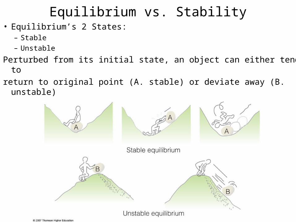
Equilibrium vs. Stability• Equilibrium’s 2 States:
– Stable
– Unstable
Perturbed from its initial state, an object can either tend to
return to original point (A. stable) or deviate away (B. unstable)
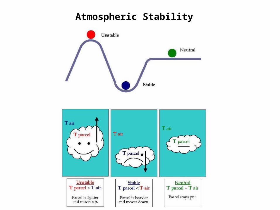
Atmospheric Stability
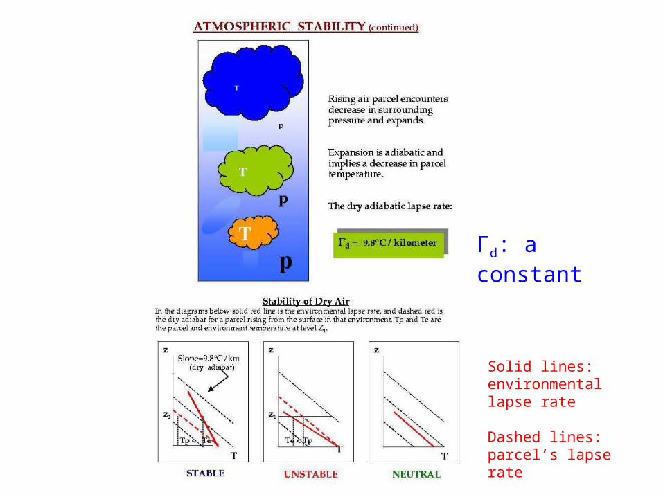
Solid lines: environmental lapse rate
Dashed lines: parcel’s lapse rate
Γd: a constant

Γw: NOT a constant
Atmospheric Stability
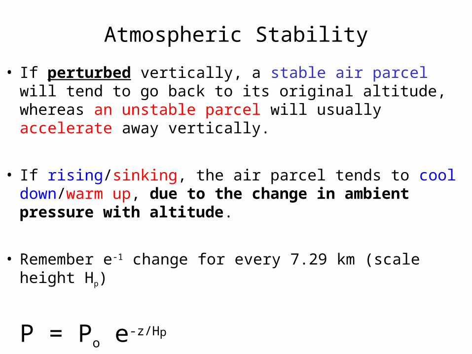
• If perturbed vertically, a stable air parcel will tend to go back to its original altitude, whereas an unstable parcel will usually accelerate away vertically.
• If rising/sinking, the air parcel tends to cool down/warm up, due to the change in ambient pressure with altitude.
• Remember e-1 change for every 7.29 km (scale height Hp)
P = Po e-z/Hp
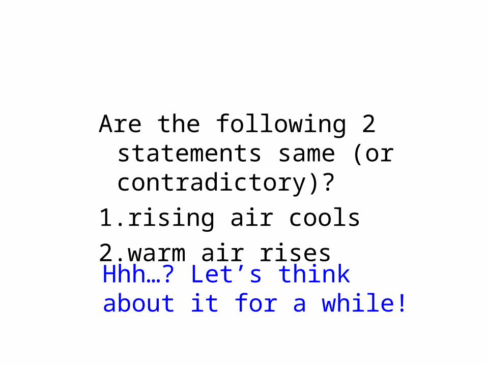
Are the following 2 statements same (or contradictory)?
1.rising air cools
2.warm air rises
Hhh…? Let’s think about it for a while!
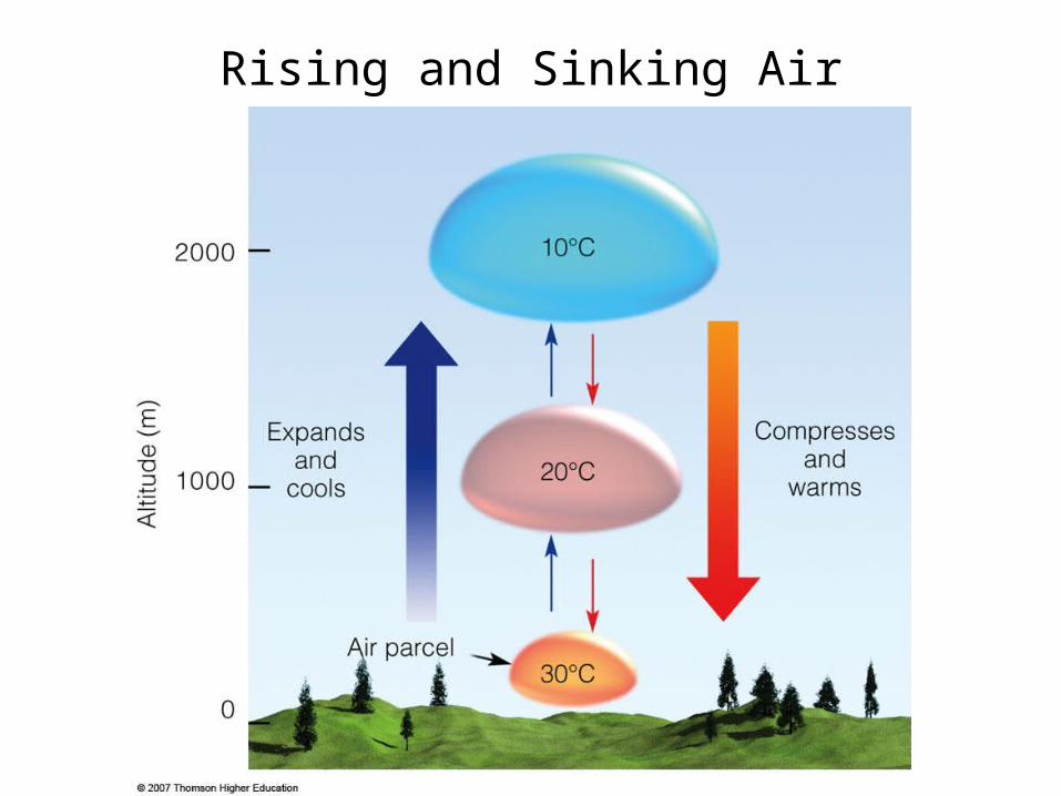
Rising and Sinking Air
Determining the temperature in a rising air parcel
consider a rising parcel of air -->>
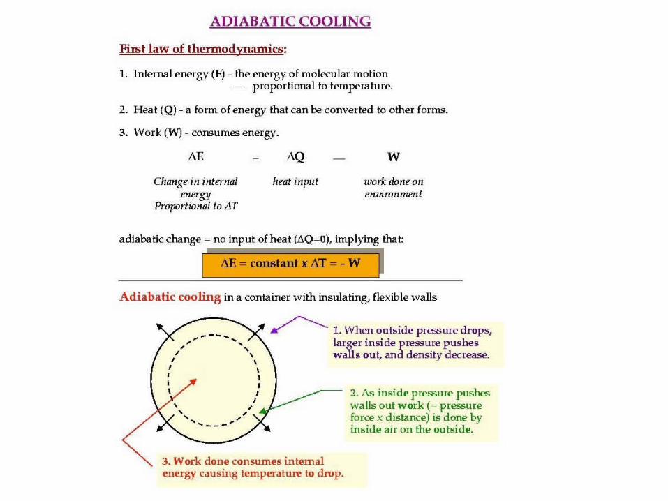
• As the parcel rises, it will adiabatically expand and cool (recall our discussion in chapter 5 about rising parcels of air)
• adiabatic - a process where the parcel temperature changes due to an expansion or compression, no heat is added or taken away from the parcel
• the parcel expands since the lower pressure outside allows the air molecules to push out on the parcel walls
• since it takes energy for the parcel molecules to "push out" on the parcel walls, they use up some of their internal energy in the process.
• therefore, the parcel also cools since temperature is proportional to molecular internal energy
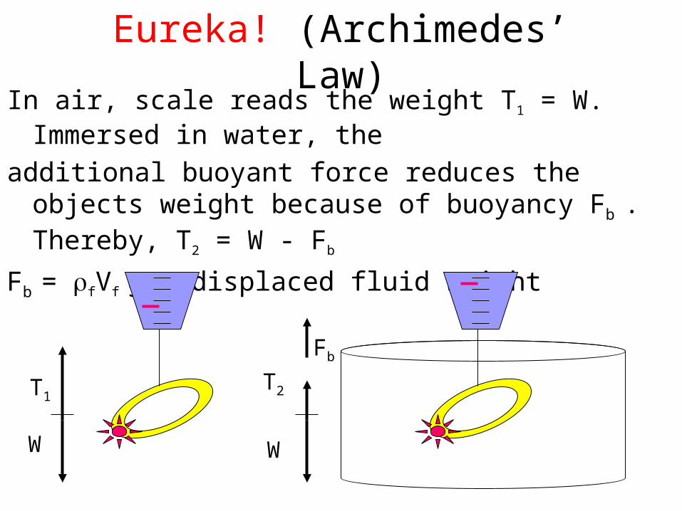
Eureka! (Archimedes’ Law)In air, scale reads the weight T1 = W. Immersed in water, the
additional buoyant force reduces the objects weight because of buoyancy Fb . Thereby, T2 = W - Fb
Fb = fVf g = displaced fluid weight
T1
W
T2
W
Fb
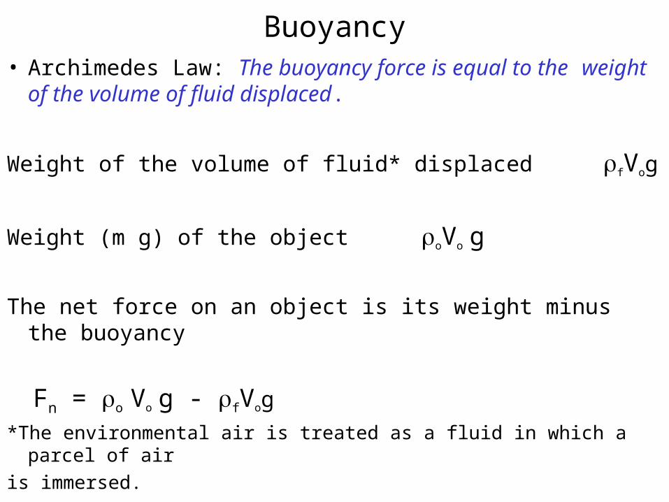
Buoyancy• Archimedes Law: The buoyancy force is equal to the weight
of the volume of fluid displaced.
Weight of the volume of fluid* displaced fVog
Weight (m g) of the object oVo g
The net force on an object is its weight minus the buoyancy
Fn = o Vo g - fVog
*The environmental air is treated as a fluid in which a parcel of air
is immersed.
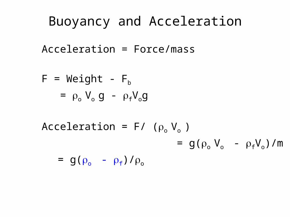
Buoyancy and Acceleration
Acceleration = Force/mass
F = Weight - Fb
= o Vo g - fVog
Acceleration = F/ (o Vo )
= g(o Vo - fVo)/m
= g(o - f)/o
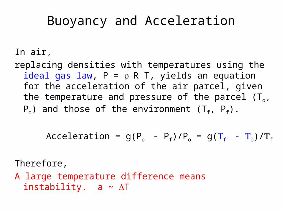
Buoyancy and Acceleration
In air,
replacing densities with temperatures using the ideal gas law, P = R T, yields an equation for the acceleration of the air parcel, given the temperature and pressure of the parcel (To, Po) and those of the environment (Tf, Pf).
Acceleration = g(Po - Pf)/Po = g(f - o)/f
Therefore,
A large temperature difference means instability. a ~ T
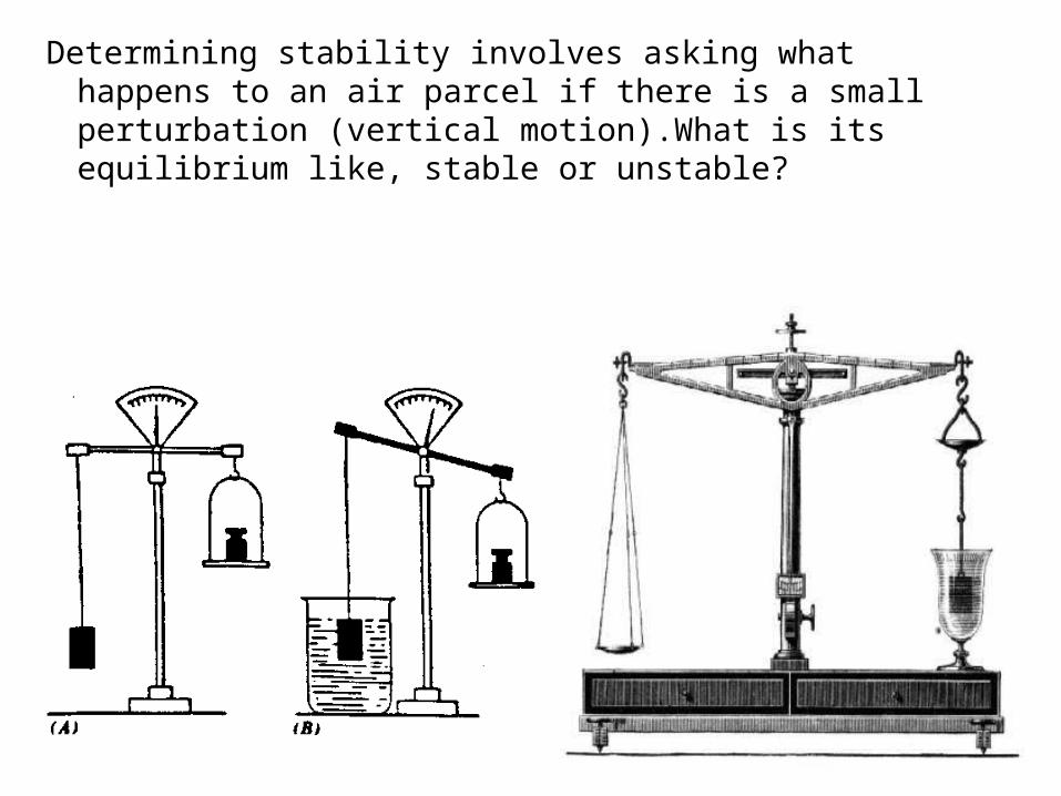
Determining stability involves asking what happens to an air parcel if there is a small perturbation (vertical motion).What is its equilibrium like, stable or unstable?
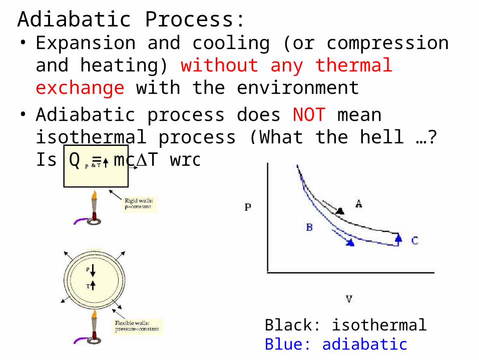
Adiabatic Process:• Expansion and cooling (or compression and heating)
without any thermal exchange with the environment• Adiabatic process does NOT mean isothermal process
(What the hell …? Is Q = mcT wrong?)
Black: isothermalBlue: adiabatic
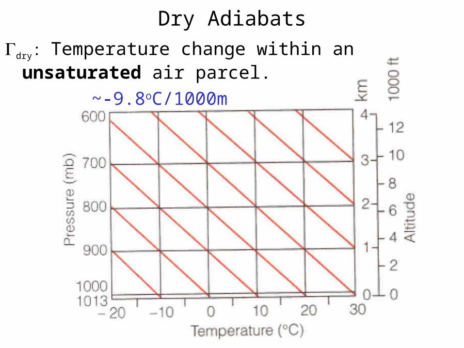
Dry Adiabats
dry: Temperature change within an unsaturated air parcel.
~-9.8oC/1000m
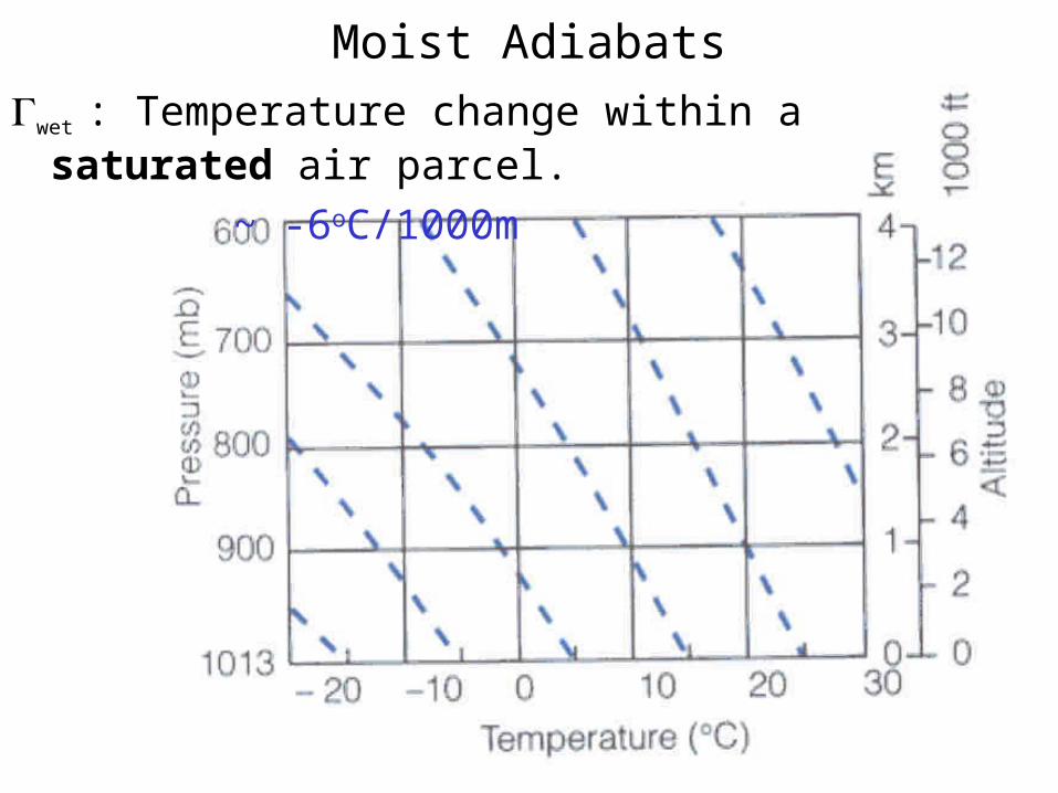
Moist Adiabats
wet : Temperature change within a saturated air parcel.
~ -6oC/1000m
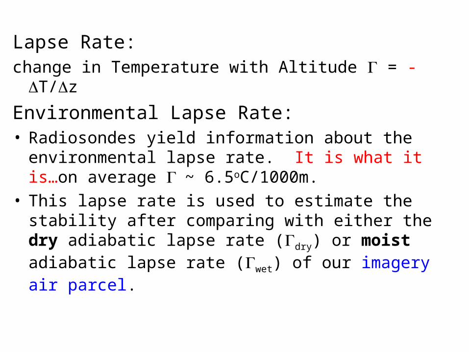
Lapse Rate:change in Temperature with Altitude = - T/z
Environmental Lapse Rate:• Radiosondes yield information about the environmental
lapse rate. It is what it is…on average ~ 6.5oC/1000m.• This lapse rate is used to estimate the stability after
comparing with either the dry adiabatic lapse rate (dry) or moist adiabatic lapse rate (wet) of our imagery air parcel.
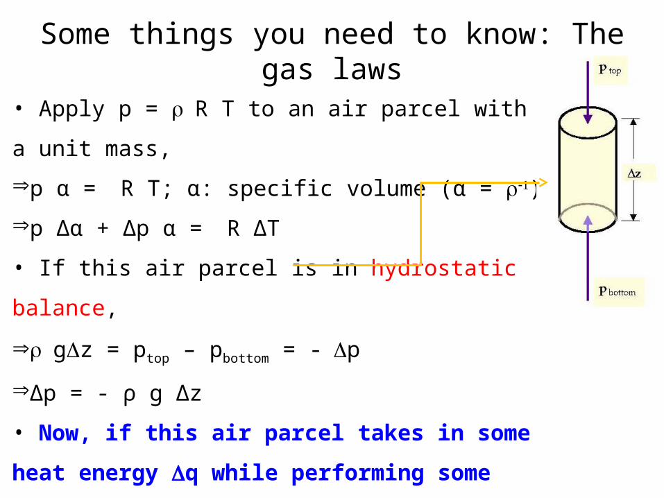
Some things you need to know: The gas laws
• Apply p = R T to an air parcel with a unit mass,
p α = R T; α: specific volume (α = )
p Δα + Δp α = R ΔT
• If this air parcel is in hydrostatic balance,
gz = ptop – pbottom = -p
Δp = - ρ g Δz
• Now, if this air parcel takes in some heat energy q
while performing some work w and causes an amount
of internal energy change u,
q = w + u = p Δ α + u (1st law of thermodynamics)
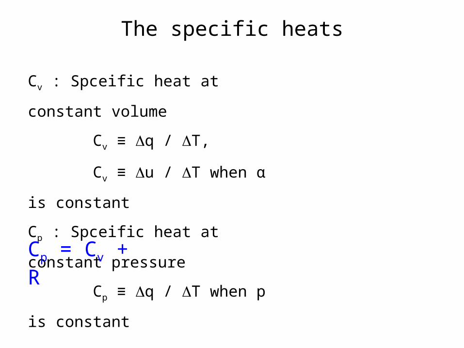
The specific heats
Cv : Spceific heat at constant volume
Cv ≡ q / T,
Cv ≡ u / T when α is constant
Cp : Spceific heat at constant pressure
Cp ≡ q / T when p is constant
Cp = Cv + R
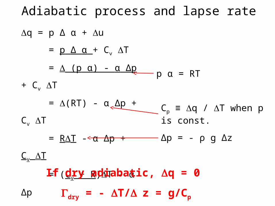
q = p Δ α + u
= p Δ α + Cv T
= (p α) - α Δp + Cv T
= (RT) - α Δp + Cv T
= RT - α Δp + Cv T
= (Cv + R)T - α Δp
= Cp T - α Δp
= Cp T + g Δz
Cp ≡ q / T when p is const.
p α = RT
Δp = - ρ g Δz
If dry adiabatic, q = 0
dry = - T/z = g/Cp
Adiabatic process and lapse rate
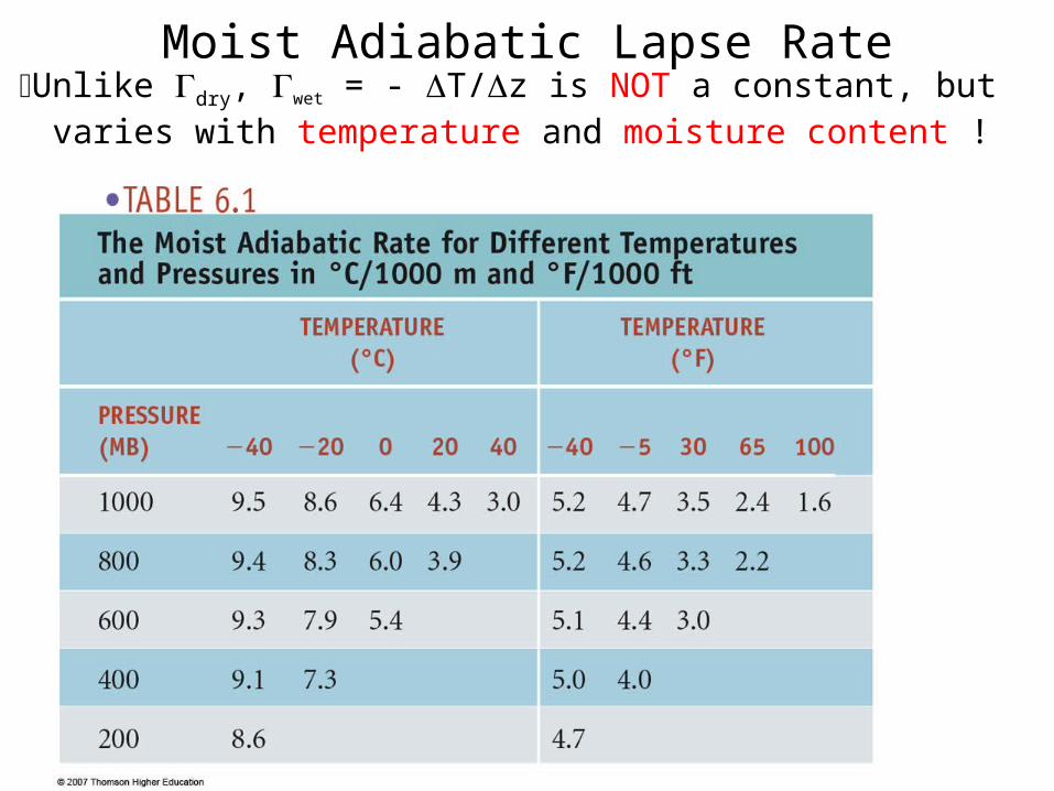
Moist Adiabatic Lapse RateUnlike dry, wet = - T/z is NOT a constant, but varies with
temperature and moisture content !
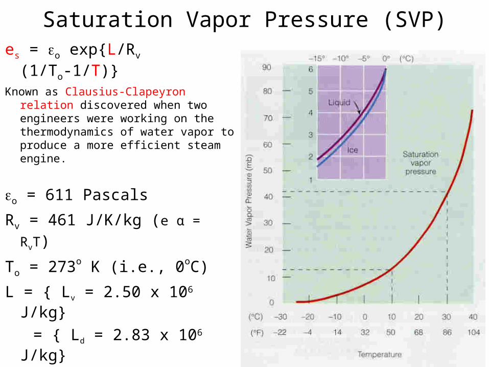
Saturation Vapor Pressure (SVP)
es = o exp{L/Rv (1/To-1/T)}Known as Clausius-Clapeyron relation
discovered when two engineers were working on the thermodynamics of water vapor to produce a more efficient steam engine.
o = 611 Pascals
Rv = 461 J/K/kg (e α = RvT)
To = 273o K (i.e., 0oC)
L = { Lv = 2.50 x 10⁶ J/kg}
= { Ld = 2.83 x 10⁶ J/kg}
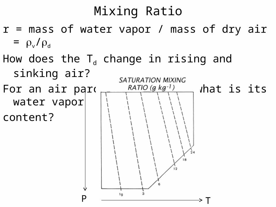
Mixing Ratio
r = mass of water vapor / mass of dry air = v/d
How does the Td change in rising and sinking air?
For an air parcel at T and P, what is its water vapor
content?
TP
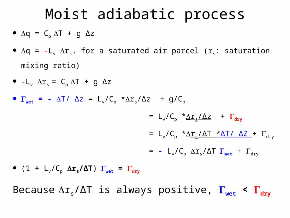
Moist adiabatic process q = Cp T + g Δz
q = -Lv rs, for a saturated air parcel (rs: saturation mixing ratio)
-Lv rs = Cp T + g Δz
wet = - T/ Δz = Lv/Cp *rs/Δz + g/Cp
= Lv/Cp *rs/Δz + dry
= Lv/Cp *rs/ΔT *ΔT/ ΔZ + dry
= - Lv/Cp rs/ΔTwet + dry
(1 + Lv/Cp rs/ΔT)wet = dry
Because rs/ΔT is always positive, wet < dry
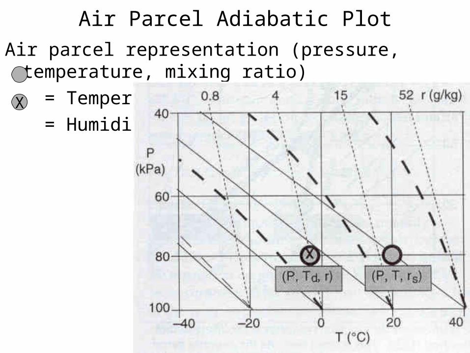
Air Parcel Adiabatic Plot
Air parcel representation (pressure, temperature, mixing ratio)
= Temperature
= HumidityX
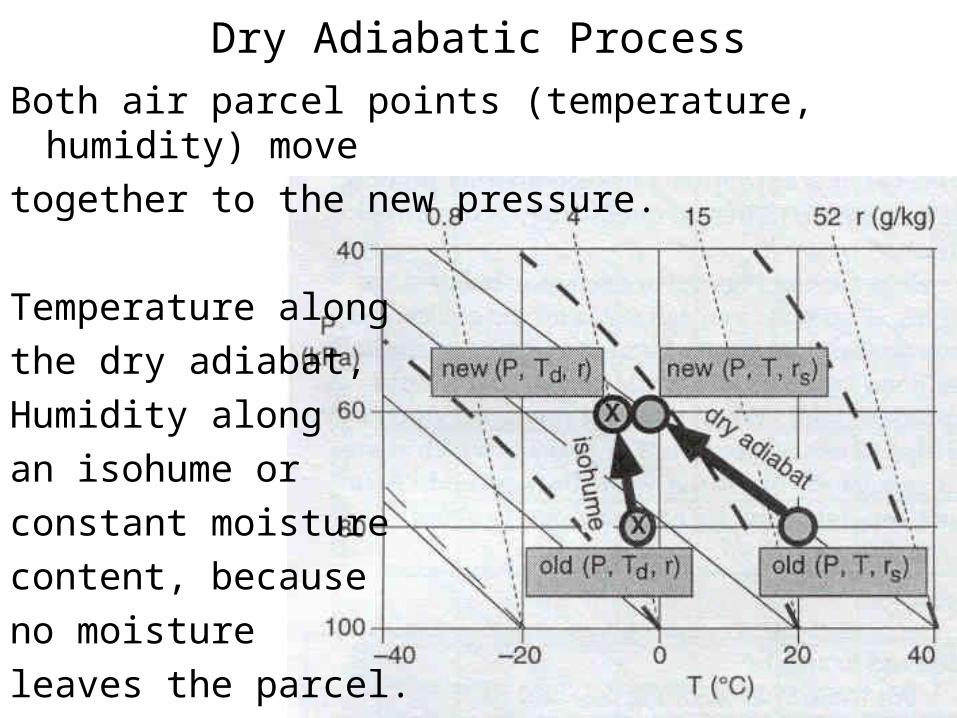
Dry Adiabatic Process
Both air parcel points (temperature, humidity) move
together to the new pressure.
Temperature along
the dry adiabat,
Humidity along
an isohume or
constant moisture
content, because
no moisture
leaves the parcel.
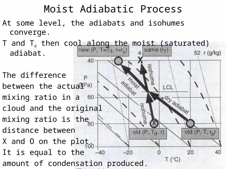
Moist Adiabatic Process
At some level, the adiabats and isohumes converge.
T and Td then cool along the moist (saturated) adiabat.
The difference
between the actual
mixing ratio in a
cloud and the original
mixing ratio is the
distance between
X and O on the plot.
It is equal to the
amount of condensation produced.
Lifting Condensation Level (LCL)When unsaturated air is lifted, it cools at the dry adiabatic rate. If
lifted high enough, the temperature will drop below the dew point.Drier air must be lifted higher than moist air to encounter LCL.
The height at which saturation just occurs is called the saturation level or the lifting condensation level (LCL).
This height (in meters) can be estimated for cumulus-type clouds and is approximated by ZLCL = 125/(T - Td), where Td is the dew point temperature derived from the vapor pressure equation encountered before:
e = o exp{Lv/Rv (1/To-1/Td)}

Absolute Stability (Dry)
The parcel of air is
cooler and heavier
than the surrounding
air around it at all
levels.
dry
When perturbed it
will tend to return to
its original position.
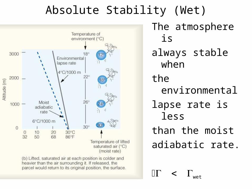
Absolute Stability (Wet)
The atmosphere is
always stable when
the environmental
lapse rate is less
than the moist
adiabatic rate.
wet
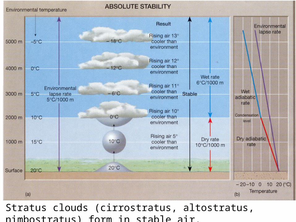
Stratus clouds (cirrostratus, altostratus, nimbostratus) form in stable air.
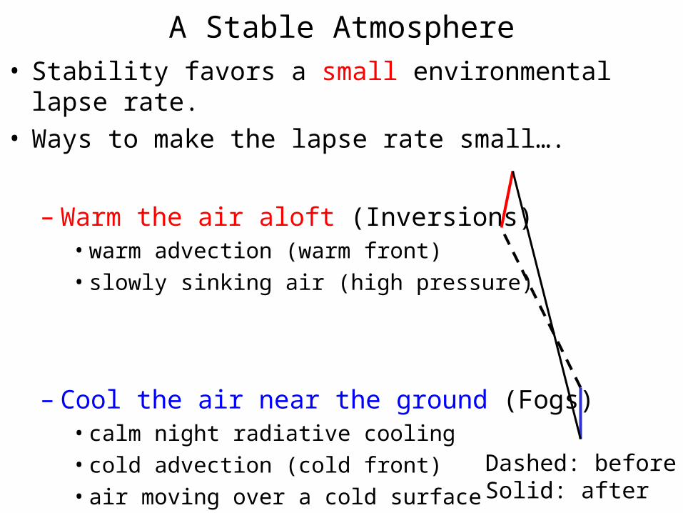
A Stable Atmosphere• Stability favors a small environmental lapse rate.• Ways to make the lapse rate small….
– Warm the air aloft (Inversions)• warm advection (warm front)
• slowly sinking air (high pressure)
– Cool the air near the ground (Fogs)• calm night radiative cooling
• cold advection (cold front)
• air moving over a cold surface Dashed: beforeSolid: after
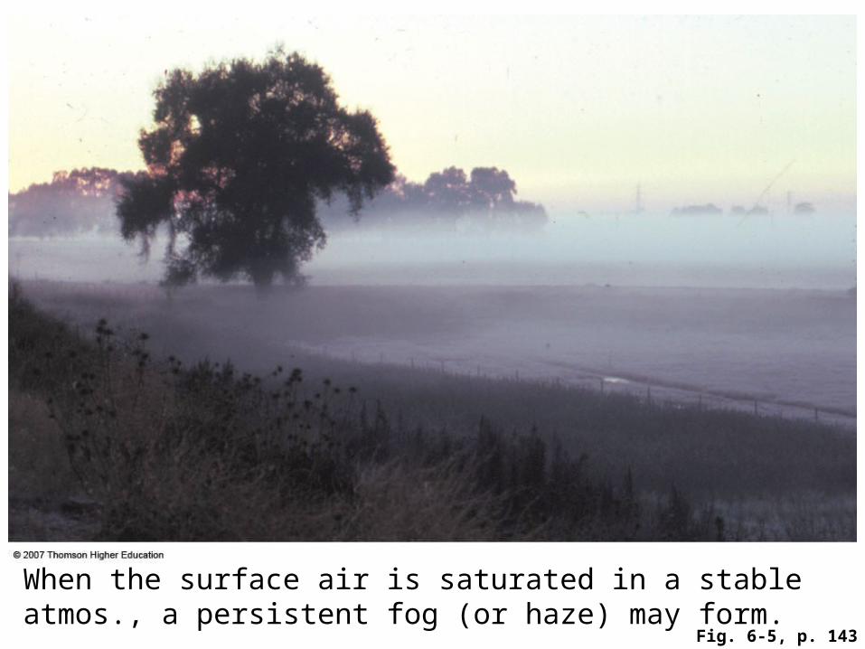
Fig. 6-5, p. 143
When the surface air is saturated in a stable atmos., a persistent fog (or haze) may form.
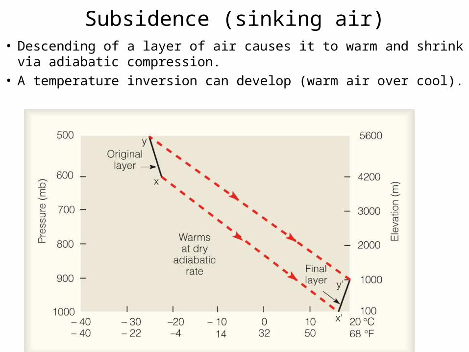
Subsidence (sinking air)• Descending of a layer of air causes it to warm and shrink via
adiabatic compression.• A temperature inversion can develop (warm air over cool).
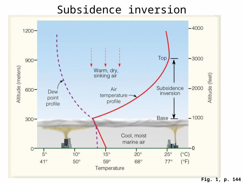
Fig. 1, p. 144
Subsidence inversion
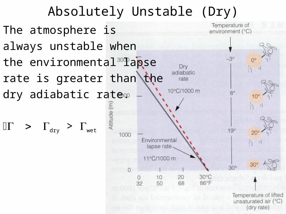
Absolutely Unstable (Dry)
The atmosphere is
always unstable when
the environmental lapse
rate is greater than the
dry adiabatic rate.
dry > wet
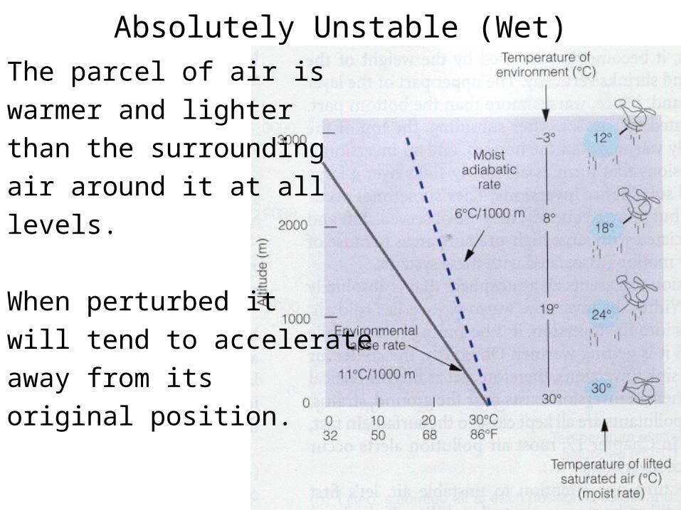
Absolutely Unstable (Wet)
The parcel of air is
warmer and lighter
than the surrounding
air around it at all
levels.
When perturbed it
will tend to accelerate
away from its
original position.
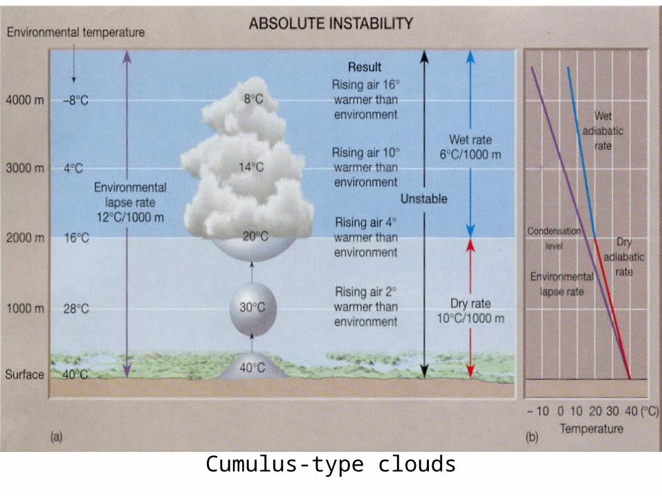
Cumulus-type clouds
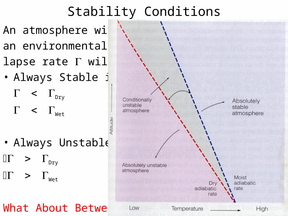
Stability Conditions
An atmosphere with
an environmental
lapse rate will be...• Always Stable if
Dry
Wet
• Always Unstable if
Dry
Wet
What About Between?
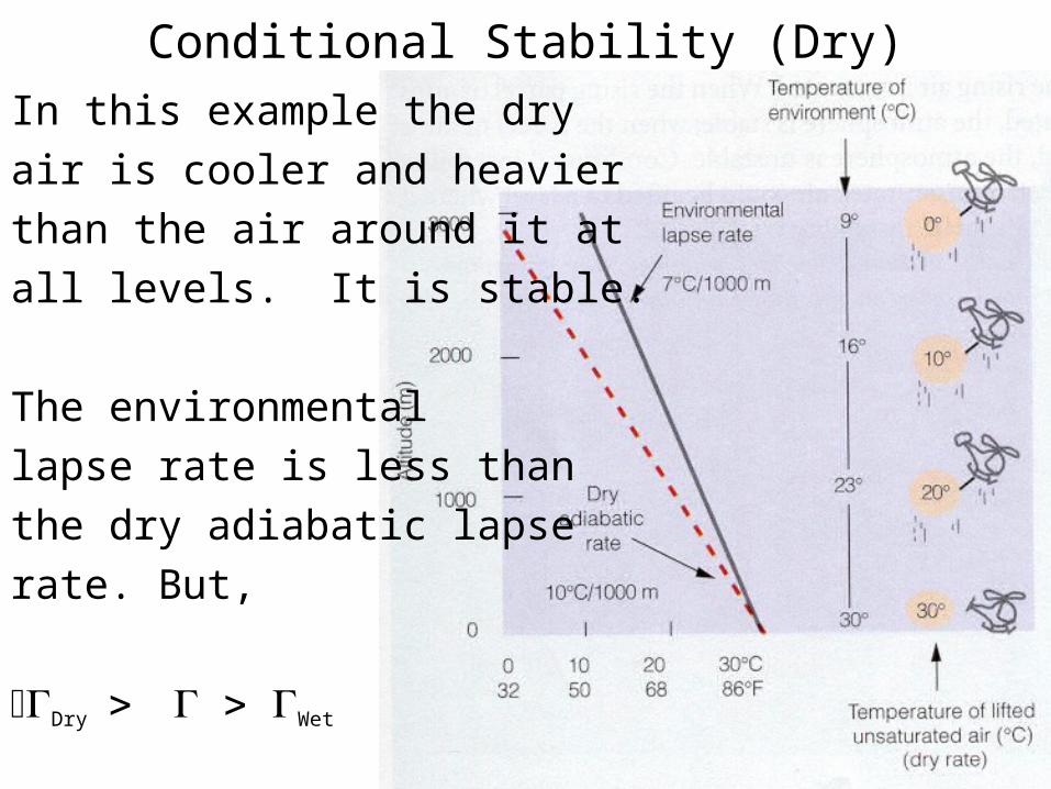
Conditional Stability (Dry)
In this example the dry
air is cooler and heavier
than the air around it at
all levels. It is stable.
The environmental
lapse rate is less than
the dry adiabatic lapse
rate. But,
Dry Wet
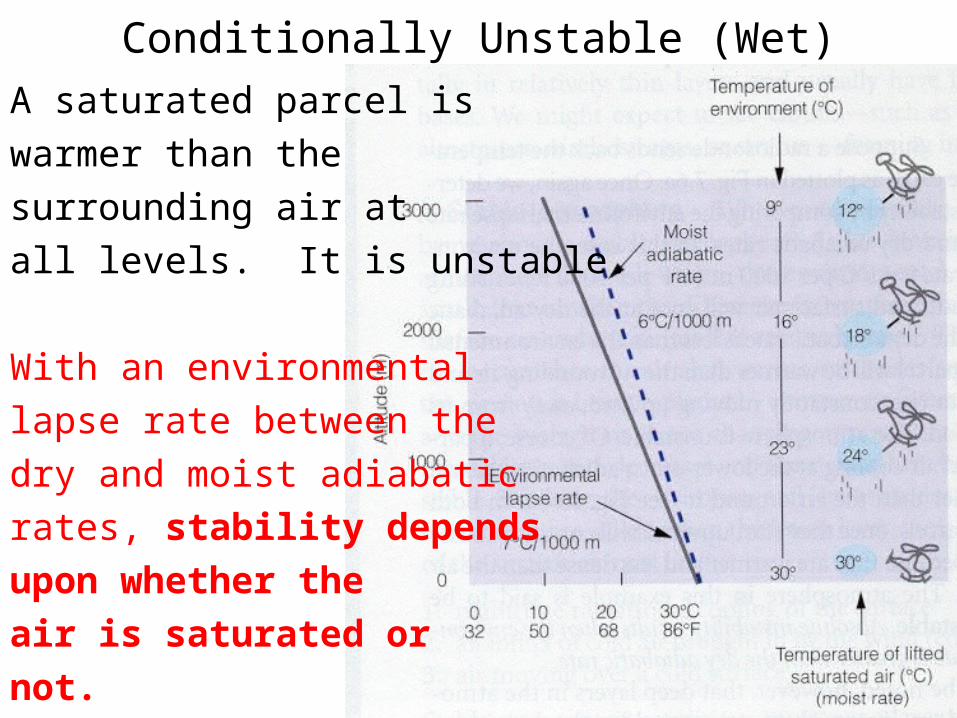
Conditionally Unstable (Wet)
A saturated parcel is
warmer than the
surrounding air at
all levels. It is unstable.
With an environmental
lapse rate between the
dry and moist adiabatic
rates, stability depends
upon whether the
air is saturated or
not.
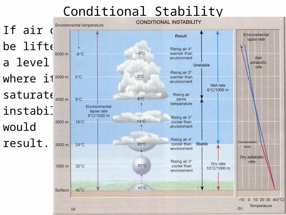
Conditional Stability
If air can
be lifted to
a level
where it is
saturated,
instability
would
result.
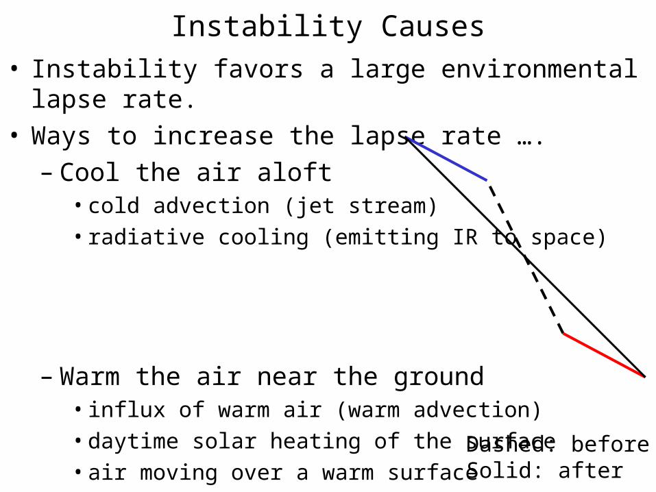
Instability Causes• Instability favors a large environmental lapse rate.• Ways to increase the lapse rate ….
– Cool the air aloft• cold advection (jet stream)
• radiative cooling (emitting IR to space)
– Warm the air near the ground• influx of warm air (warm advection)
• daytime solar heating of the surface
• air moving over a warm surface Dashed: beforeSolid: after
雲階胞狀層積雲
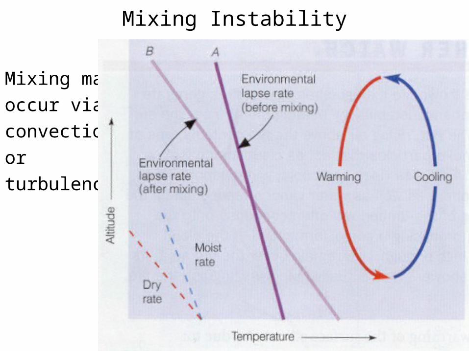
Mixing Instability
Mixing may
occur via
convection
or
turbulence.
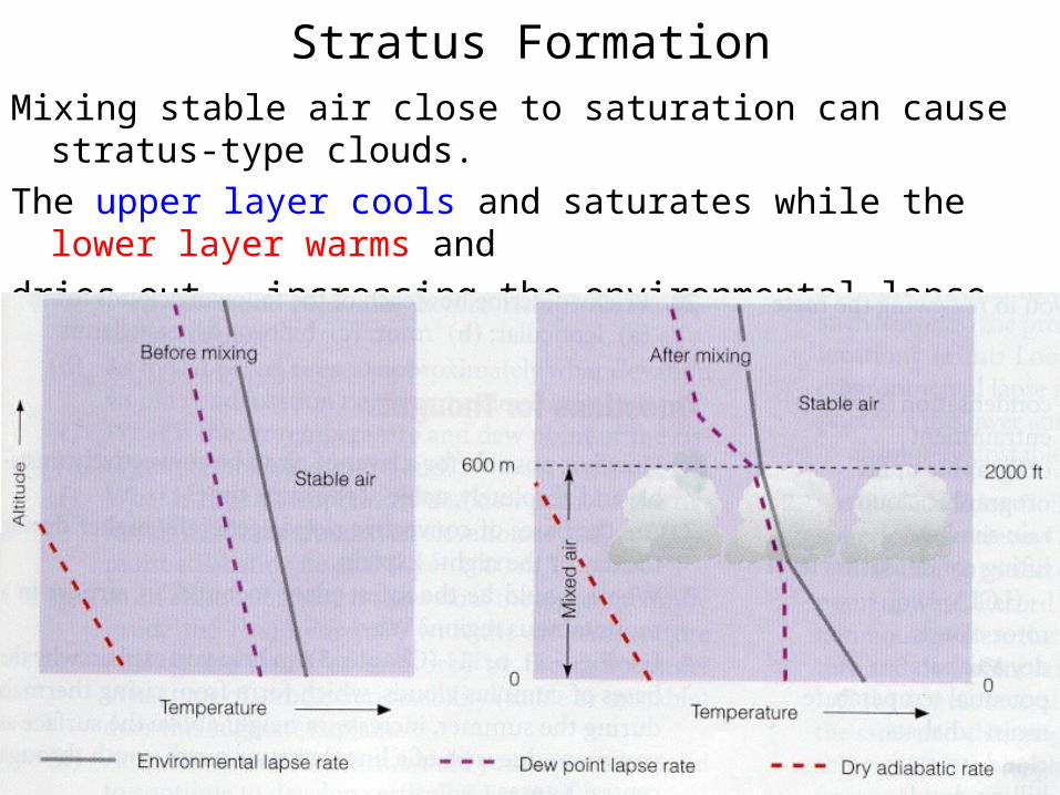
Stratus FormationMixing stable air close to saturation can cause stratus-type clouds.
The upper layer cools and saturates while the lower layer warms and
dries out, increasing the environmental lapse rate.
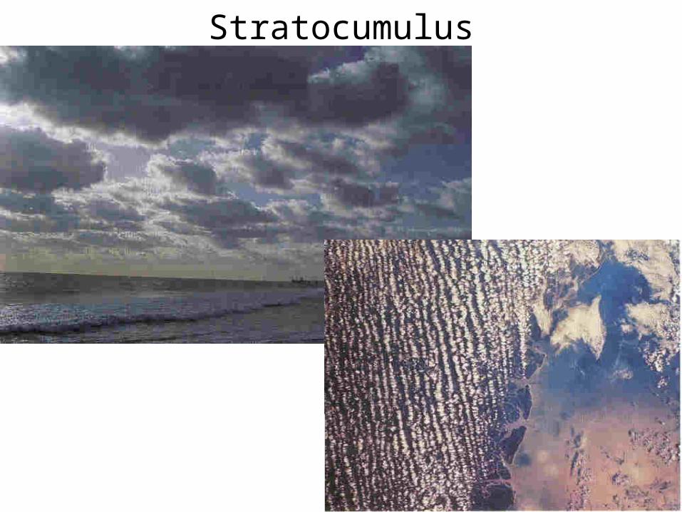
Stratocumulus
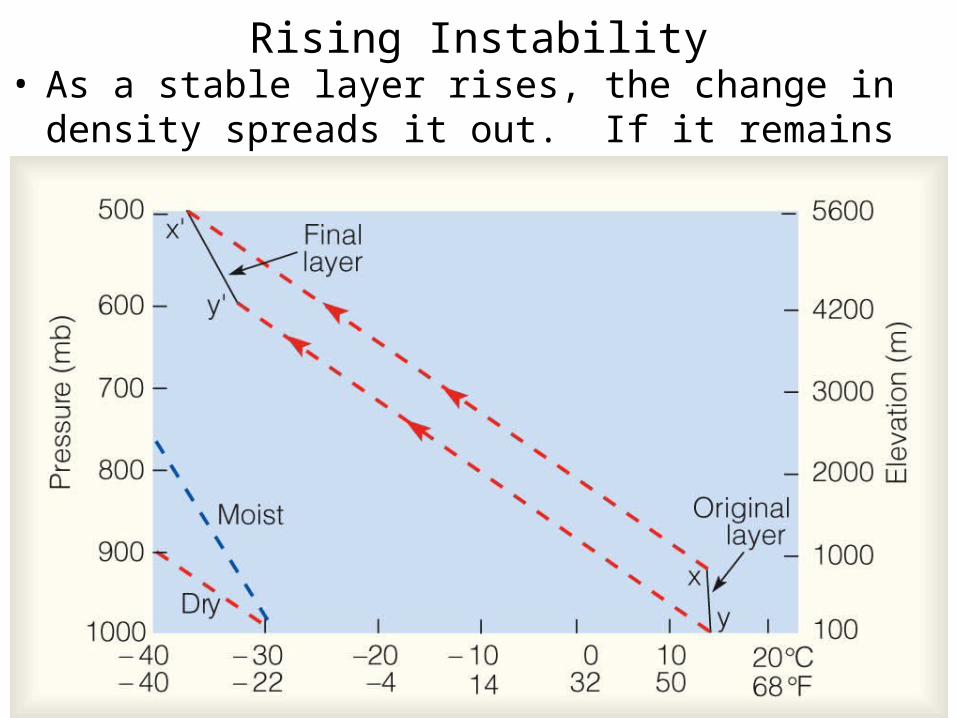
Rising Instability• As a stable layer rises, the change in density spreads it out.
If it remains unsaturated, the top cools faster than below.
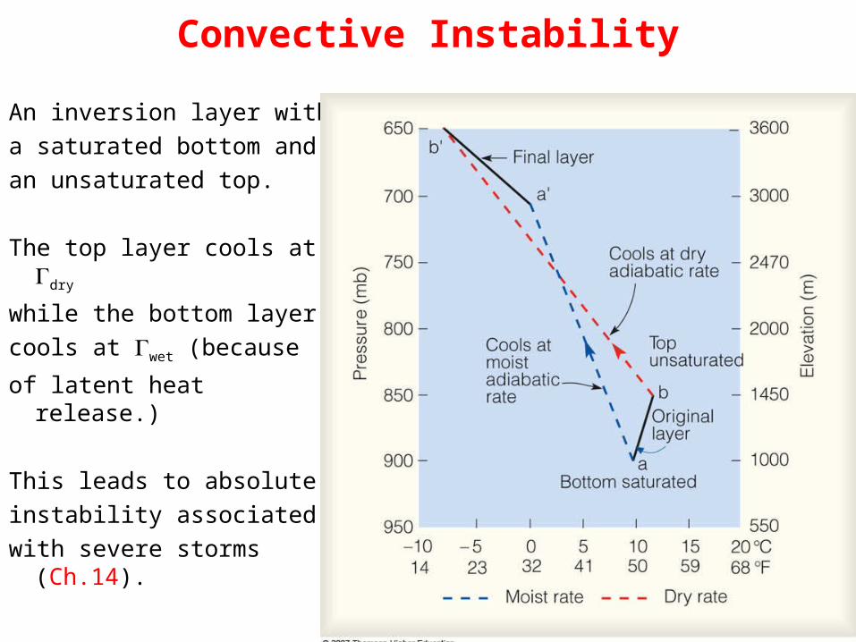
Convective Instability
An inversion layer with
a saturated bottom and
an unsaturated top.
The top layer cools at dry
while the bottom layer
cools at wet (because
of latent heat release.)
This leads to absolute
instability associated
with severe storms (Ch.14).
Mechanisms responsible for cloud development
• Convective Uplift
• Orographic Uplift
• Convergence Uplift
• Frontal Uplift
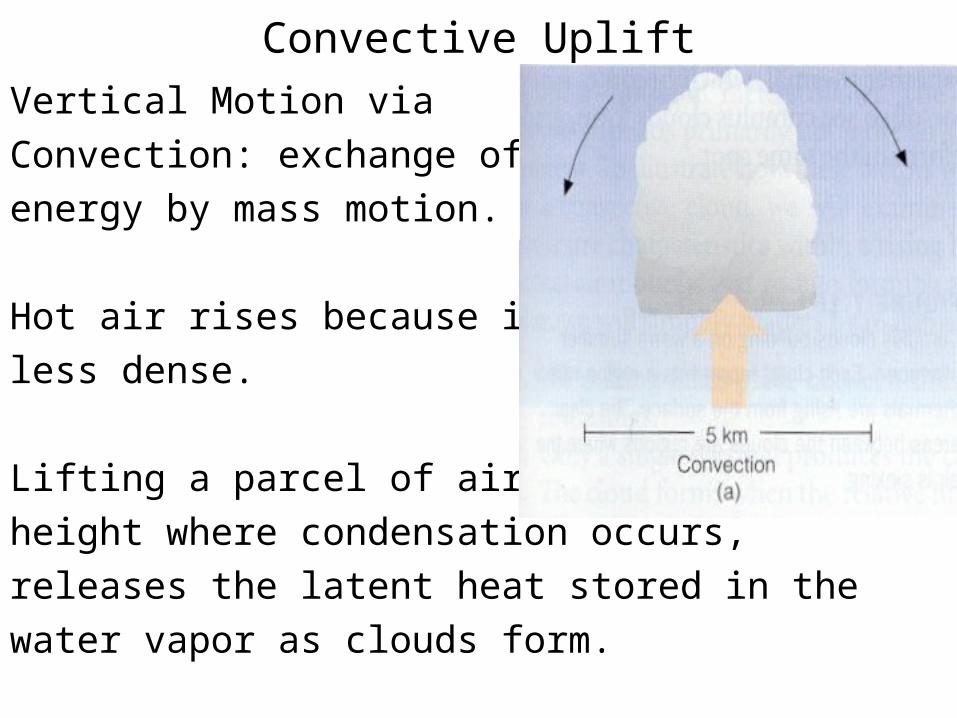
Convective Uplift
Vertical Motion via
Convection: exchange of thermal
energy by mass motion.
Hot air rises because it is
less dense.
Lifting a parcel of air to a
height where condensation occurs,
releases the latent heat stored in the
water vapor as clouds form.
Convective Cloud Heights
• Cumulus-type cloud height is approximated as ZLCL = 125/(T - Td), where the constant 125 comes from the difference on average between Dry ~ 10oK/1000m and DewPt ~ 2oK/1000m.
• With knowledge of the air temperature and dew point, determining cumulus cloud base heights is simple.
• With observation of cloud base height and air temperature, the dew point (hence moisture content) is estimated.
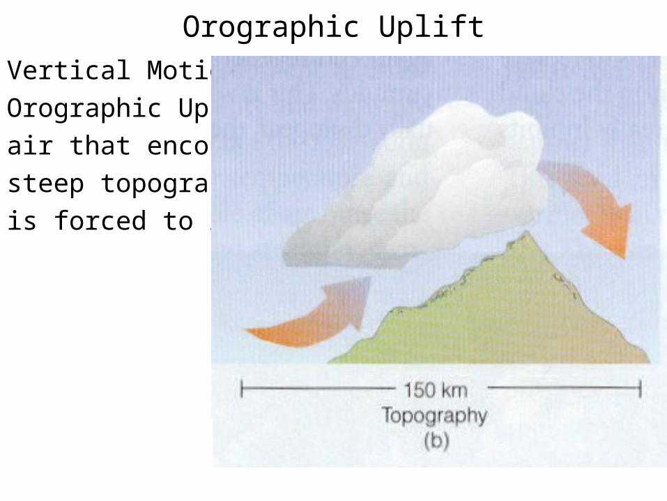
Orographic Uplift
Vertical Motion via
Orographic Uplift:
air that encounters
steep topography
is forced to rise.
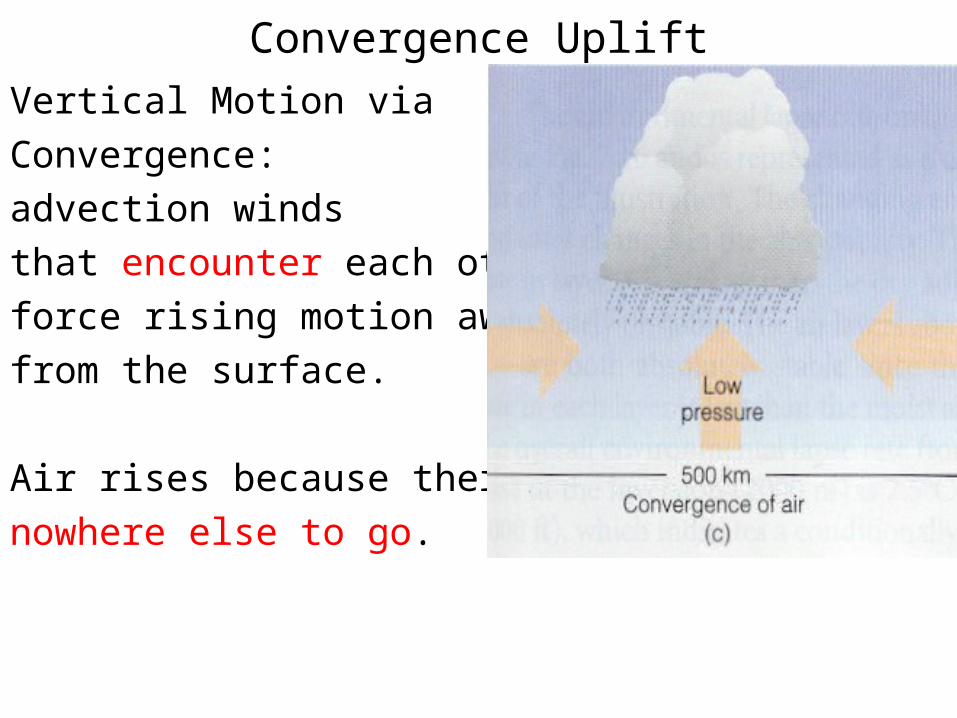
Convergence Uplift
Vertical Motion via
Convergence:
advection winds
that encounter each other
force rising motion away
from the surface.
Air rises because there is
nowhere else to go.
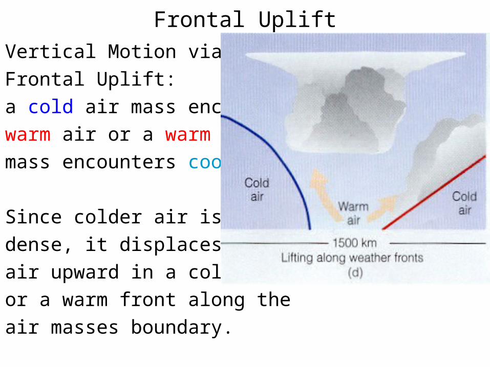
Frontal Uplift
Vertical Motion via
Frontal Uplift:
a cold air mass encounters
warm air or a warm air
mass encounters cooler air.
Since colder air is more
dense, it displaces the warm
air upward in a cold front
or a warm front along the
air masses boundary.
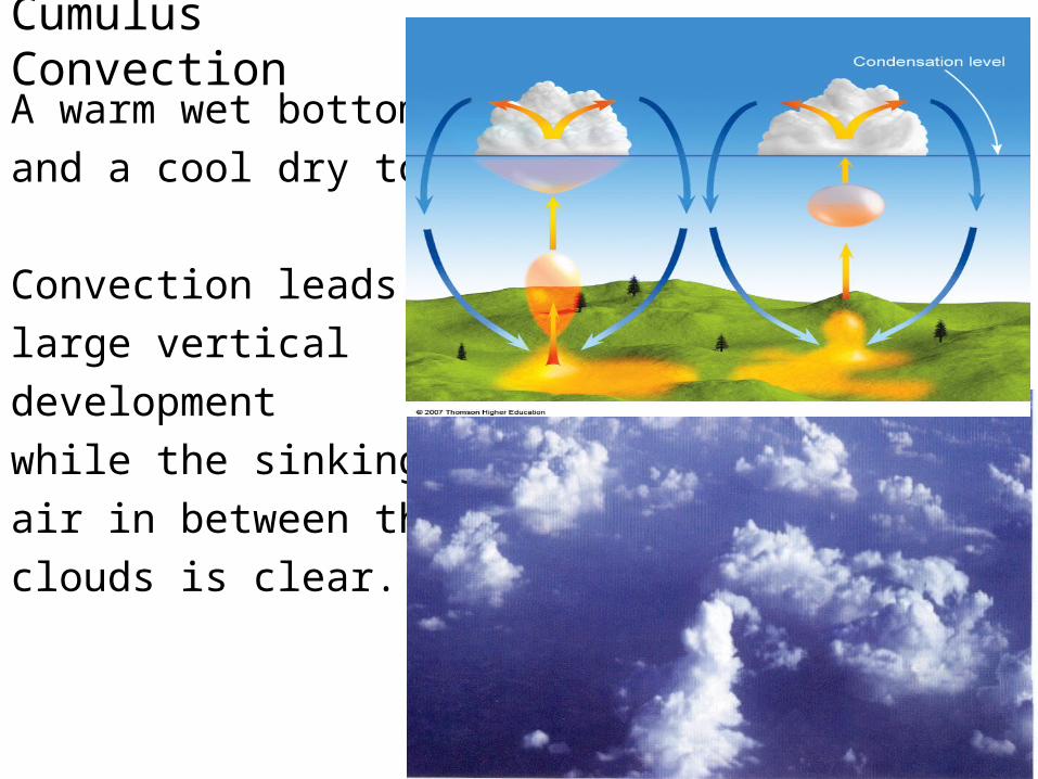
Cumulus Convection
A warm wet bottom
and a cool dry top.
Convection leads to
large vertical
development
while the sinking
air in between the
clouds is clear.
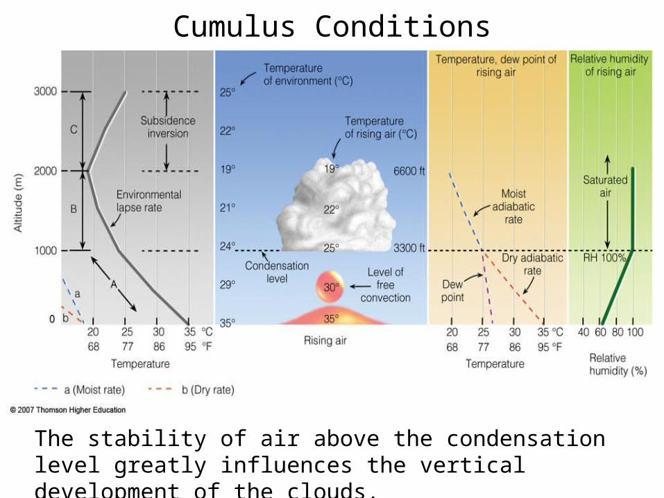
Cumulus Conditions
The stability of air above the condensation level greatly influences the vertical development of the clouds.
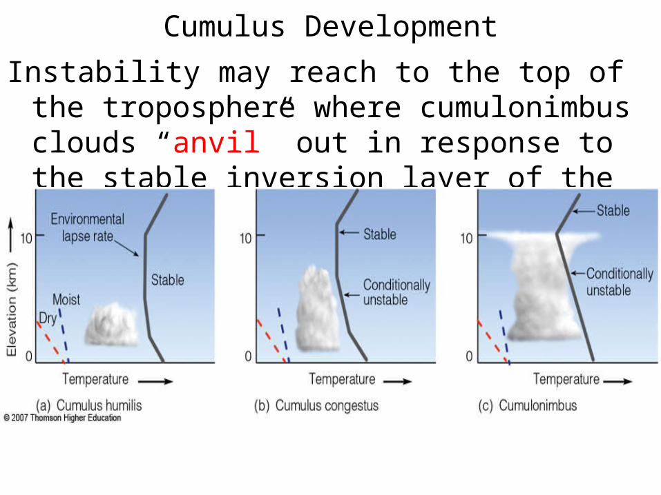
Cumulus Development
Instability may reach to the top of the troposphere where cumulonimbus clouds “anvil” out in response to the stable inversion layer of the stratosphere.
Entrainment
• Entrainment: mixing of environmental air into a current, jet or convection (cloud).
• When mixing of cooler, dry air occurs into convectively
unstable clouds, the clouds cool much more quickly. The rate of cooling can approach the dry adiabatic rate and the convective instability will cease.
• If the air is warm and moist, the instability grows along with the vertical development. Hence, our interest in water vapor (moisture) and infrared (cloud heights) images.
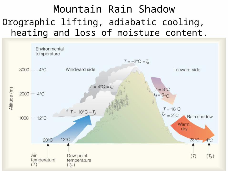
Mountain Rain ShadowOrographic lifting, adiabatic cooling, heating and loss of
moisture content.

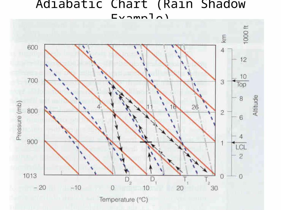
Adiabatic Chart (Rain Shadow Example)
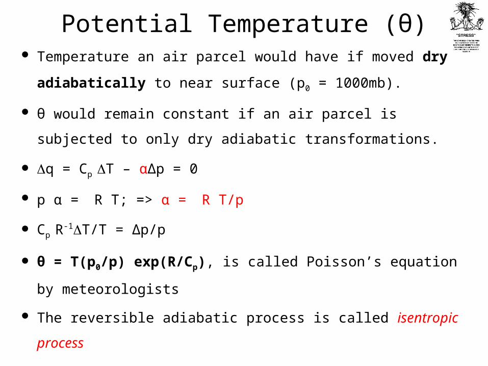
Potential Temperature (θ) Temperature an air parcel would have if moved dry adiabatically to
near surface (p0 = 1000mb).
θ would remain constant if an air parcel is subjected to only dry
adiabatic transformations.
q = Cp T – αΔp = 0
p α = R T; => α = R T/p
Cp R-1T/T = Δp/p
θ = T(p0/p) exp(R/Cp), is called Poisson’s equation by
meteorologists
The reversible adiabatic process is called isentropic process
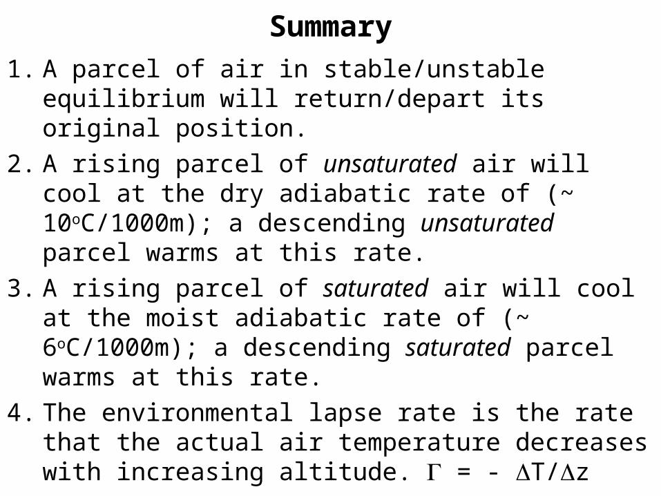
Summary
1. A parcel of air in stable/unstable equilibrium will return/depart its original position.
2. A rising parcel of unsaturated air will cool at the dry adiabatic rate of (~ 10oC/1000m); a descending unsaturated parcel warms at this rate.
3. A rising parcel of saturated air will cool at the moist adiabatic rate of (~ 6oC/1000m); a descending saturated parcel warms at this rate.
4. The environmental lapse rate is the rate that the actual air temperature decreases with increasing altitude. = - T/z
Summary (cont.)
5. Absolute Stability: Air at surface is cooler than air aloft (inversion), or the environmental lapse rate is greater than the dry adiabatic rate.
6. Instability can be initiated if surface air warms, air aloft cools, or vertical lifting occurs (convection, convergence, fronts, topography).
7. Conditional Instability: Environmental lapse rate is between the moist and dry adiabatic rates. Unsaturated air is lifted to a point where condensation occurs and becomes warmer than the surrounding air.


