45
GEU 0047: Meteorology Lecture 9 Wind: Small-Scale and Local Systems
| Date post: | 13-Dec-2015 |
| Category: |
Documents |
| Upload: | august-tate |
| View: | 219 times |
| Download: | 0 times |

GEU 0047: MeteorologyLecture 9
Wind: Small-Scale and Local Systems
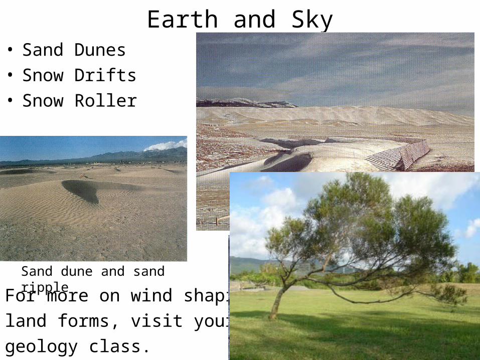
Earth and Sky• Sand Dunes• Snow Drifts• Snow Roller
For more on wind shaping
land forms, visit your nearest
geology class.
Sand dune and sand ripple

Wind Speed Vectors
Vectors are arrows representing wind direction and
speed.

Wind Data
Wind Vane
Direction*
*Direction indicates
wind origin NOT
direction it is
blowing.
Wind anemometer
Speed


Wind Direction Compass
Clockwise
Convention
• North = 0o
• East = 90o
• South = 180o
• West = 270o

Onshore/Offshore• Other direction indicators based on geology and geography.
– (valley breeze, mountain breeze)

Wind Rose• Average Wind Direction in a given location.• An indicator of “prevailing winds.”
Winds in this representation
are mostly from the West,
predominantly from the NW
(from due East only 10%).
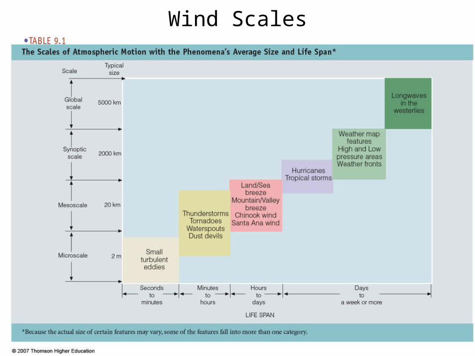
Wind Scales

Small-scale Winds• Microscale: turbulence, gusts, wind devils, dust devils
• Mesoscale: sea breeze, valley/mountain breezes, tornadoes
• Macroscale: Westerlies, Jets, Fronts,Cyclones (L), Anticyclones (H)
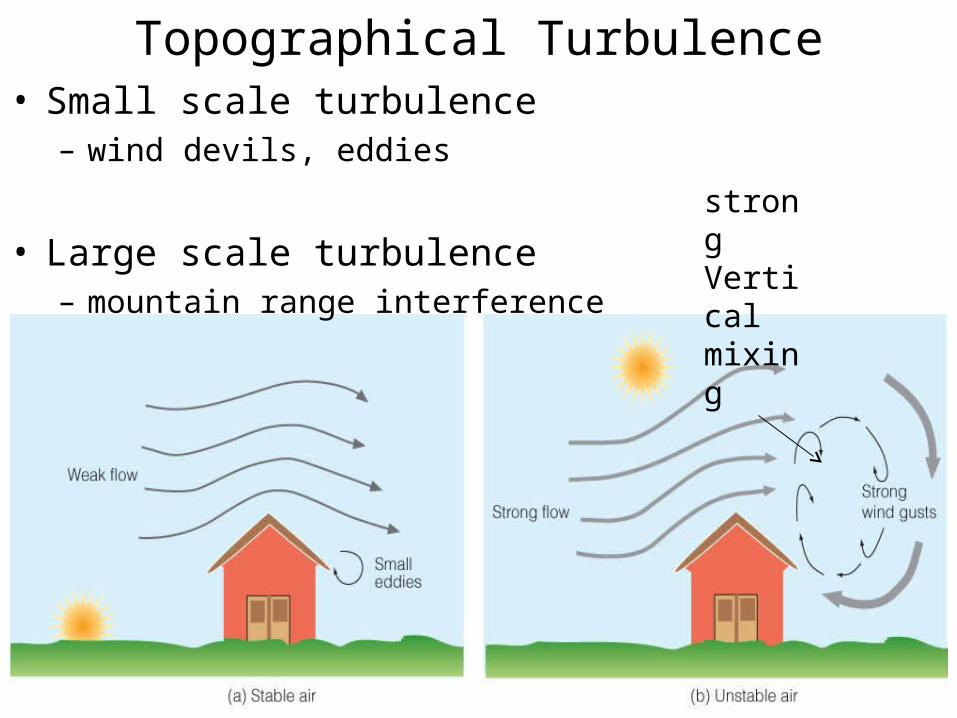
• Small scale turbulence– wind devils, eddies
• Large scale turbulence– mountain range interference
Topographical Turbulence
strongVertical mixing

Wind Reversal• A wind gust caused by ground topography.
Jeffreys’ Sheltering model: The rear face of the topography against which the wind blows experiences a higher pressure than the front face, which is sheltered from the force of the wind. Air eddies formed in front of it lead to pressure differences that push the wind reversal.

Wind BreakNear the surface, friction plays a major role in wind speed
“Flag” trees created in an area with
winds coming from one predominant
direction (prevailing winds).
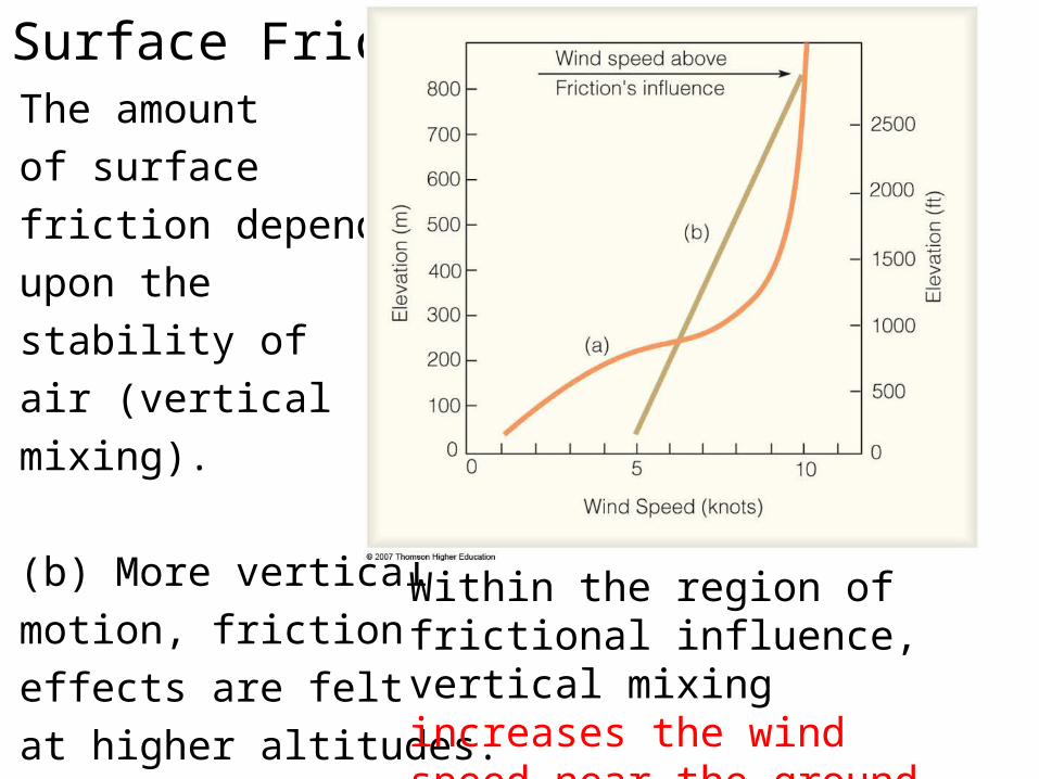
Surface FrictionThe amount
of surface
friction depends
upon the
stability of
air (vertical
mixing).
(b) More vertical
motion, friction
effects are felt
at higher altitudes.
Within the region of frictional influence, vertical mixing increases the wind speed near the ground and decreases it aloft.

Mountain Peak Eddies• The size and shape of eddies depends upon wind speed and
the size and shape of the obstacle that created the eddies.
The eddies are
created down
wind of the
obstacle.
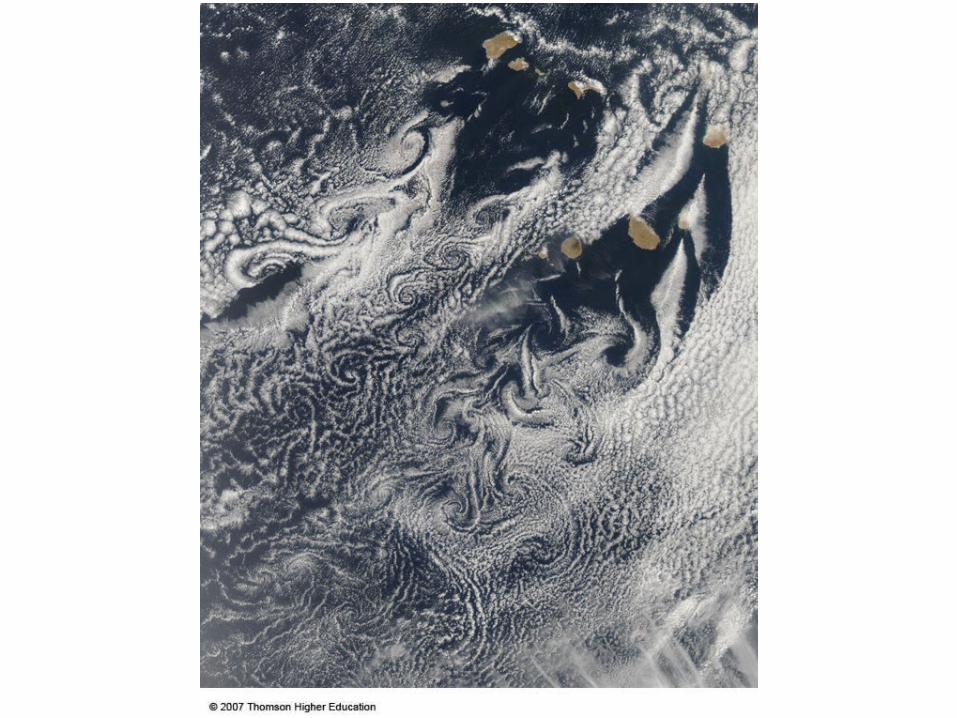

Island Wakes (Hawaii Islands)

Mountain Waves
Wave clouds created downwind
of a mountain range.

Kelvin-Helmholtz Instability (e.g., CAT)• Wind Shear Turbulence creating “billow” clouds.

Thermal CirculationZero Pressure Gradient
Zero Wind
Temperature Differences
Create PGF and wind
Air piles up and descends
to create high pressure near
the surface, flowing to low
pressure only to rise at a
surface low

Thermal Highs and Lows• Thermal pressure systems:
– Are near the surface– Weaken with altitude– Maintained by uneven heating in local areas

Convergence/Divergence• Surface Lows and Surface Highs need the support of upper
level divergence and convergence to grow and intensify.

Sea Breeze During Day• Differential Heating of Land and Sea.• Cool wet marine air with warm dry continental air.• Daytime heat (convection), land develops a low, ocean a
high (subsidence).

Land Breeze at Night• Nighttime land IR cooling, land high, ocean low.• Reversal of daytime highs and lows and winds.


Florida Convergence Low• Daytime sea breezes from both coasts yield frequent
afternoon thunderstorms over central Florida in summer.


Lake Winds
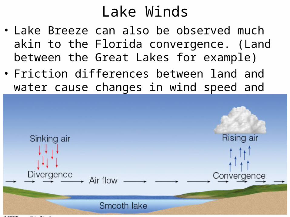
Lake Winds• Lake Breeze can also be observed much akin to the Florida
convergence. (Land between the Great Lakes for example)• Friction differences between land and water cause changes
in wind speed and direction which can create low and high pressures.

Heavy lake-effect snow hits Great Lakes states
Moisture from the lakes produced lake-effect snow on the eastern and southern shores of the lakes
Lake breezes and lake effects

Mountain and Valley Breeze• Diurnal cycle: Air on slopes is heated and is hotter than the
air in the valley at the same altitude. • It rises, creating “valley breeze.”• Radiative cooling in the evening causes a wind reversal, and
“mountain breeze.”
*purple lines are isobars

Orographic Uplift• Mountain Breeze forming cumulus clouds along the Grand
Tetons.• As mountain slopes warm during the day, air rises and often
condenses into cumuliform clouds,

• Hawaii Sea Breeze and Orographic Uplift.
Hawaii Sea Breeze

Katabatic Wind• Cold dense air descending from elevated plateau regions
through canyons and valley gaps in mountains in the arctic.

Chinook Wind• Warm dry air associated with mountains. Rockies, Alps, Andes
• Adiabatic compression and heating of air as it descends mountains.
• Formed in response to low pressure systems moving air across the mountains.
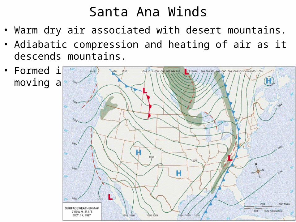
Santa Ana Winds• Warm dry air associated with desert mountains.
• Adiabatic compression and heating of air as it descends mountains.
• Formed in response to high pressure systems moving air across the mountains.

A blustery, dry and warm (often hot) wind that blows out of the desert. In Raymond Chandler's story Red Wind, the title being one of the offshore wind's many nicknames, the Santa Anas were introduced as "those hot dry [winds] that come down through the mountain passes and curl your hair and make your nerves jump and your skin itch.

Fig. 9-36, p. 247

Haboob
• Dust Storm caused by the down draft associated with strong approaching thunderstorms.

Dust Devil• Heated air rises and is funneled by circulation around
obstacles that create eddies.
• Unstable convection at the surface


Nor’Easter Conditions
Almost hurricane-like
circulation around
strong low pressure
cyclones can create
gale force winds and
lots of precipitation
(blizzards in the winter)

• The storm forming off the coast of Nova Scotia, Canada, was nothing remarkable in itself. It was following the typical pattern of a "northeaster," a weather system that often affects the eastern coast of the United States and Canada during the fall and winter.
• However, Hurricane Grace had been collecting large quantities of energy—in the form of moisture and warm air—as it spun past the island of Bermuda. While Hurricane Grace's behavior was typical for the fall hurricane season, what was not typical was its collision with the northeaster off of Nova Scotia and the cold air behind it.
• When that collision took place on Tuesday, October 29, Grace donated its massive supply of prepackaged energy to the northeaster.
Science behind

Local winds that originate over North Africa


![Manual Bombas Dosificadoras 339-0047-000[1]](https://static.documents.pub/doc/80x56/551579364a7959d2028b5247/manual-bombas-dosificadoras-339-0047-0001.jpg)


