GEWEX, needs of the GEWEX, needs of the water cycle modeling water cycle modeling community community and SWOT and SWOT Peter van Oevelen Peter van Oevelen (Eric Wood) (Eric Wood) Presentation for SWOT Workshop, September 15-17, 2008, The Ohio State University, Columbus Ohio
Transcript
GEWEX, needs of the water cycle GEWEX, needs of the water cycle modeling communitymodeling community
and SWOT and SWOT
Peter van OevelenPeter van Oevelen(Eric Wood)(Eric Wood)
Presentation for SWOT Workshop,September 15-17, 2008,
The Ohio State University, Columbus Ohio
Presentation for SWOT Workshop,September 15-17, 2008,
The Ohio State University, Columbus Ohio
OutlineOutline
• GEWEX structureGEWEX structure– Introduction: where, what, why, how etc.Introduction: where, what, why, how etc.
• Rationale for SWOT and links to GEWEX’s Rationale for SWOT and links to GEWEX’s Panels and activitiesPanels and activities
• Other international bodies to be consideredOther international bodies to be considered
The ToolsThe Tools
GEWEX achieves its goals through data set development andanalysis, process studies and model improvement
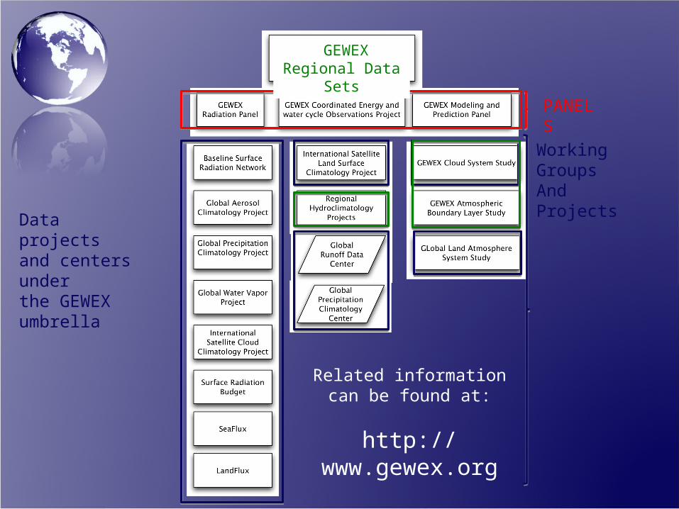
PANELS
Working Groups And Projects
GEWEXRegional Data Sets
Data projectsand centers underthe GEWEXumbrella
Related information can be found at:
http://www.gewex.org
Some of the RationaleSome of the Rationale• Global Data Sets of surface water (rivers and lakes) level Global Data Sets of surface water (rivers and lakes) level
datadata– By itself useful for monitoring purposes e.g. flood mapping, lake By itself useful for monitoring purposes e.g. flood mapping, lake
storage etc.storage etc.• Contribution to the Global Runoff Data Centre global Contribution to the Global Runoff Data Centre global
discharge data setsdischarge data sets– Counter measure against diminishing numbers of run-off gaugesCounter measure against diminishing numbers of run-off gauges
• Closure of regional and global water budgetsClosure of regional and global water budgets• Evaluation/Verification of Hydrological Models – outputEvaluation/Verification of Hydrological Models – output• Calibration of Hydrological ModelsCalibration of Hydrological Models• Input to Hydraulic ModelsInput to Hydraulic Models• River and lake information for Ungauged BasinsRiver and lake information for Ungauged Basins
• GRP aims at long term data sets with strict GRP aims at long term data sets with strict data quality controldata quality control
• Both integrated and single sensor data sets Both integrated and single sensor data sets
CEOPCEOP
• GRDC – Global Runoff Data Center (Affiliated GRDC – Global Runoff Data Center (Affiliated with GEWEX-CEOP)with GEWEX-CEOP)
• Regional Data SetsRegional Data Sets– Regional Hydroclimate Projects (Former CSE’s) Regional Hydroclimate Projects (Former CSE’s)
• Hydrological Applications ProjectHydrological Applications Project– Hydrological Test bedsHydrological Test beds
• CEOP Cross-cutting activities:CEOP Cross-cutting activities:– Monsoons, High Elevation, Modelling, Water and Monsoons, High Elevation, Modelling, Water and
Energy Budget StudiesEnergy Budget Studies
GMPPGMPP
• GMPP is GEWEX Model Development PanelGMPP is GEWEX Model Development Panel• New land surface schemes and New land surface schemes and
parameterizations based upon ‘new’ type of parameterizations based upon ‘new’ type of datadata
• Assimilation proceduresAssimilation procedures• At what scales will SWOT data be most useful At what scales will SWOT data be most useful
and applicable -> which models (local and applicable -> which models (local hydrological models to NWP)hydrological models to NWP)
• River discharge, Water use, Ground water, River discharge, Water use, Ground water, Lake levels, Lake levels,
• Snow cover, Glaciers and ice caps, Permafrost Snow cover, Glaciers and ice caps, Permafrost and seasonally-frozen ground, and seasonally-frozen ground,
• Albedo, Land cover (including vegetation Albedo, Land cover (including vegetation type), Fraction of absorbed photosynthetically type), Fraction of absorbed photosynthetically active radiation (fAPAR), Leaf area index (LAI), active radiation (fAPAR), Leaf area index (LAI), Biomass, Fire disturbance, Biomass, Fire disturbance,
Other Obvious International Other Obvious International LinksLinks
• GTN-H: Global Terrestrial Network – GTN-H: Global Terrestrial Network – HydrologyHydrology
• GWSP : Global Water Systems Project as part GWSP : Global Water Systems Project as part of the Earth System Science Partnership of the Earth System Science Partnership (ESSP)(ESSP)
• UNESCO-IHP and PUBUNESCO-IHP and PUB• GEO and its GEOSSGEO and its GEOSS• ……
SWOT needs a higher profile in international programs to help provide visibility for the mission.