55
Glaciofluvial Deposits Coastal glacial outwash plain, Svalbard Brian Romans, Virginia Tech

Glaciofluvial Deposits
Coastal glacial outwash plain, SvalbardBrian Romans, Virginia Tech

Deposition from glacial meltwater
• On, within or beneath a glacier
• In front of a glacier
• Proximal zone (10s to 100s of m)
• Medial zone (100s m to 10s km)
• Distal zone (10s to 100s of km)
• The Quadra Sand
• The Nanaimo River valley GF deposits
Glaciofluvial sedimentation is generally similar to fluvial sedimentation, except where it is in
contact with the ice.
Another difference is that the water is generally colder and denser, and also more viscous, so
particles behave differently.
Finally, glacial outflows can be highly seasonal, even more than fluvial flows in our wet-dry
climate. And of course outburst floods (Jökulhlaups) can be an influence.

Sedimentation on or within a glacier
• Supraglacial and englacial channels may have little friction, so sediments tend to move through quite readily (in any case we don’t typically get to see these types of deposits)
• Subglacial channels typically have much higher friction (like regular streams)
• Subglacial streams are generally confined to tunnels, so can’t spread out like regular streams. Eskers are the result.

http://www.nichols.edu/

Sinuous esker ridge of classic form that has melted out of glacier ice in 1992. The bouldery ridge in the background is the inner face of the substantial lateral morainesurrounding the rapidly retreating Stagnation Glacier. The landform is actually composed mostly of glacial ice preserved by the insulating cover of a meter, more or less, of bouldery esker gravel. (Photograph taken by Christian Zdanovich.) (W. Shilts, http://www.prairie.illinois.edu)
Stagnation Glacier, Bylot Island, Nunavut, Canada

Northern Canada
Manitoba

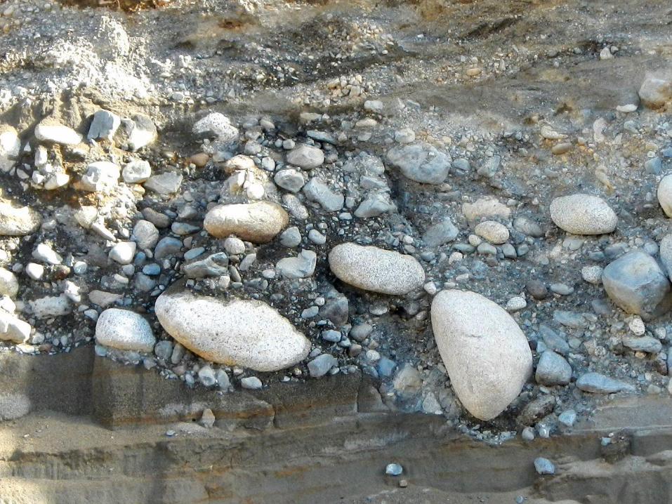
Proximal zone (10s to 100s of m)
• Coarse materials (coarse sand, gravel, pebbles and cobbles)
• Chaotic depositional patterns
• Rugged topography leads to mud and debris flows
• Deposition on buried ice is common and leads to post-depositional collapse and deformation
• Braided streams are the norm
• May be highly influenced by seasonal variations

Downcutting through end-moraine deposits, Thompson Glacier, Canadian Arctic, http://libwiki.mcmaster.ca

Northwest margin of Aktineq Glacier, Bylot Island, Nunavut
W.W. Shilts, http://www.prairie.illinois.edu

Greenland, K. Tintohttp://www.ldeo.columbia.edu/research/blogs/arctic-thaw-measuring-change,

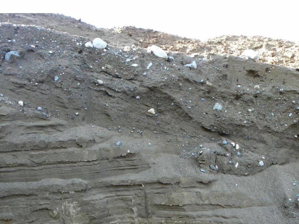
Medial zone (100s of m to several km)
• Braided streams (sand and gravel)
• Longitudinal bars (coarsest)
• Transverse bars
• Point bars (finer, with cross-bedding common)
• Grain size decreases down stream


Brahmaputra River, Tibet http://c-p-d-studio.blogspot.ca

Dibang River, Arunachal Pradesh, India http://c-p-d-studio.blogspot.ca

Sandur in southern Iceland, south of Vatnajökull ice cap. Photo: J. Alean, 1978 http://www.swisseduc.ch/glaciers/glossary/sandur-en.html
Sandur: extensive flat plain of sand and gravel with braided streams of glacial meltwater flowing across it. Sandurs are usually not bounded by valley walls and commonly form in coastal areas.

Robson Glacier, BC, August 2012

Distal zone (10s of km)
• Mostly sand
• Under normal discharge the flow is confined to a single channel
• Decreased glacial influence, less seasonal
• Transition to a conventional river system (i.e., from predominantly braided to predominantly meandering)

Tasman River, South Island, New Zealand, fed by Tasman Glacier off the picture to the right, and the Hooker and Mueller glaciers in the valley in the centre background. Photo M. J. Hambrey. http://www.swisseduc.ch/glaciers/glossary/braided-stream-en.html

From Bennett and Glasser, 2009

Coarse gravel of proximal sandur
Gravel and sand ofmiddle sandur
Sand and silt ofdistal sandur
Coarse gravel of proximal sandur
Coarse gravel of proximal sandur
Gravel and sand ofmiddle sandur
Sand and silt ofdistal sandur
After Bennett and Glasser, 2009

Criteria for recognition of glaciofluvial depositsCode Facies description Interpretation
Gm Massive, matrix-supported gravel Debris flow
GmsGmi
Massive crudely bedded gravel, horizontal bedding, clastimbrication
Longitudinal bars, channel lag deposits
Gt Stratified gravel with trough cross beds Minor channel fills
Gp Stratified gravel with planar cross beds Transverse or linguoid bars
St Medium to coarse sand, pebbles, with trough cross beds Dunes
Sp Fine to very coarse sand, pebbles, with planar cross beds Transverse or linguoid bars
ShFine to very coarse sand, pebbles, with horizontal laminations
Planar bed flow, high flow regime
SsFine to very coarse sand, pebbles, with horizontal laminations
Minor channels or scour hollows
Fl Sand, silt and mud with ripple marksWaning flood deposits and overbank deposits
Fm Mud and silt with dessication cracks Deposits formed in pools
After Bennett and Glasser, 2009

Characteristics of Jökulhlaup Deposits
Dominant facies Secondary facies Depositional environment
Guc, Guf, Gxp, Gxt, Blg Gh, Sh, Suf, Go, St, Sp, FlJökulhlaup drainage from ice-dammed or subglacial lake
(uc: upward coarsening, uf: upward fining, xp, xt: large-scale planar and trough cross beds, Go: open work gravels)
Gm, Gx, Gh, Sm,Suc, Guc
Guf, Suf, Gt, Gp, St, Sp, Sh, FI, Bm
Jökulhlaup drainage during subvolcaniceruption
After Maizels, 1997

Quadra Sand

After Clague et al., 2004

After Clague et al., 2004
Quadra Is.
Comox
Deep Bay

After Clague et al., 2004
Quadra Sand at Point Grey

Quadra Sand at
Point Grey
After Clague et al., 2004

After Clague et al., 2004
Quadra Sand at Point Grey

Quadra Sand at Point Grey
Clague , 1976

After May, 2007, VIU GEOL-490

Quadra Sand at Comox
Fisher, 2009, U. Vic. MSc.

Unit 5
Unit 4

Unit 3

Unit 3

Unit 3
Unit 2

Unit 2

Quadra Island


After Clague et al., 2004
Quadra Is.
Comox
Deep Bay

Hub City Gravel Pit


Nick’s annotation


Nanaimo River Valley at last deglaciation?

Nanaimo River Valley at last deglaciation?


