GOFC-GOLD Fire: an International Program for the Coordination of Fire Observations C. O. Justice University of Maryland, Department of Geography I. Csiszar NOAA/NESDIS, Center for Satellite Applications and Research J.G. Goldammer Global Fire Monitoring Center http://gofc-fire.umd.edu
Transcript
GOFC-GOLD Fire: an International Program for the Coordination of
Fire Observations
C. O. JusticeUniversity of Maryland, Department of Geography
I. CsiszarNOAA/NESDIS, Center for Satellite Applications and Research
J.G. GoldammerGlobal Fire Monitoring Center
http://gofc-fire.umd.edu
Remote Sensing and Operational
R and D
Fire Science Research andGlobal Change
Research
Operational Fire and Resource
Management andPolicy
Fire Observing Systems- Experimental - Operational
GOFC/GOLDFire
Promote interaction between a number of major communities
Where are we trying to go? 1. Fire Monitoring • Secure the necessary Fire Observations to support
science and applications – satellite and ground based • Global geostationary network – standard algorithms
(characterized differences) – <1km spatial - 15 minute repeat – NRT delivery – active fire and FRP
• Long term polar orbiting record AM/PM – global BA products – known accuracy – continuous record
• International constellation of operational high resolution sensors providing 5 day cloud free global coverage
• Periodic global mapping of vegetation structure - 10m?• Targeted rapid tasking of 3m-1m sensors or UAV’s
providing disaster monitoring and post fire assessment• Free and open satellite data access and sharing• National ground based observation systems in place –
open data sharing
2. Fire Management – Improved use of earth observations for NRM– Global early warning system in place complementing
national EWS – Satellite fire data used for national fire monitoring as
appropriate – Regional sharing of fire management resources –
emergency response– Standardized national annual reporting w. known accuracy
utilizing satellite assets where appropriate – Science to inform fire policies based on understanding of
fire ecology and current resources at risk– Operational NRT Fire Emissions Modeling in place – Fire / Air Quality policies and monitoring systems in place– Public access to NRT information on fire risk and locations– Post fire assessment supported by satellite data leading to
burned area recovery
Where are we trying to go?
3. Fire Science– Better understanding of fire, land use, ecosystem and
climate feedbacks– Accurate estimation of regional/global fire annual
emissions– Improved understanding of fire role in Carbon and
Biogeochemical Cycles – Fire, Smoke, Cloud interactions further understood– Fire ecology informing fire policy and management at
the local level – Integrated modeling of future fire trends based on
improved climate, socio economics and policy scenarios
– Etc
Where are we trying to go?
GOFC-GOLD Fire Implementation Team• Arino, Olivier – ESA, Italy• Badarinath, KVS – NRSA, India• Chuvieco, Emilio – U. Alcala, Spain• Csiszar, Ivan – NOAA, USA• DeGroot, Bill – CFS, Canada• Goldammer, Johann – Co-chair, GFMC, Germany • Grant, Allan - Australia• Justice, Chris – Co-chair, UMd, USA• Lorenz, Eckehard – DLR, Germany• Loupian, Evgeny – SRI, Russia• Lynham, Timothy – CFS, Canada• Sukhinin, Anatoly – SFI, Russia
Regional Network Fire Coordinators (GOFC network coordinator – Olga Krankina) • South and Central America (REDLATIF) – Carlos DiBella, Argentina • SE Asia - Mastura Mahmud, Malaysia • Southern Africa (SAFNET) – Wisdom Dlamini, Philip Frost, Navashni Govender • West Africa (WARN) - Cheikh Mbow, Senegal • Northern Eurasia – Evgeny Loupian, Russia International Land Direct Readout Committee• Brian Schwind – USA, Rainer Ressl - Mexico, Craig Smith- AustraliaCEOS Land Product Validation Working Group – Fire Focus Leads• Kevin Tansey- UK, Luigi Boschetti – USA
GOFC-GOLD Fire website
gofc-fire.umd.edu
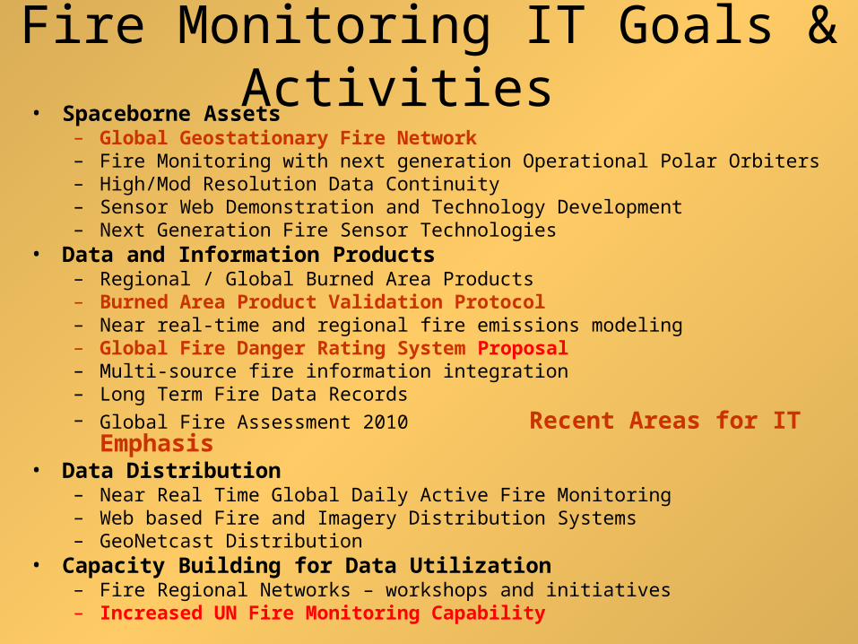
Fire Monitoring IT Goals & Activities
• Spaceborne Assets – Global Geostationary Fire Network – Fire Monitoring with next generation Operational Polar Orbiters– High/Mod Resolution Data Continuity – Sensor Web Demonstration and Technology Development– Next Generation Fire Sensor Technologies
• Data and Information Products – Regional / Global Burned Area Products– Burned Area Product Validation Protocol– Near real-time and regional fire emissions modeling – Global Fire Danger Rating System Proposal – Multi-source fire information integration– Long Term Fire Data Records – Global Fire Assessment 2010 Recent Areas for IT Emphasis
• Data Distribution – Near Real Time Global Daily Active Fire Monitoring– Web based Fire and Imagery Distribution Systems– GeoNetcast Distribution
• Capacity Building for Data Utilization – Fire Regional Networks – workshops and initiatives – Increased UN Fire Monitoring Capability
• Current GOFC-GOLD fire network initiatives – in partnership with the regional wildland fire networks
• SAFNET- Southern Africa (http://safnet.umd.edu/)• SEARRIN - South East Asia (http://www.eoc.ukm.my/searrin/) • OSFAC - Central Africa (http://osfac.umd.edu/)• REDLATIF - Latin America (http://mob.conae.gov.ar/redlatif/)• NERIN – Northern Eurasia (http://www.fao.org/gtos/gofc-gold/net-NERIN.html)
• Emerging Observation Networks• Australasia• Mediterranean• East Asia - (under discussion)• South Asia – (under discussion)
GOFC-GOLD Regional Fire Networks
http://www.safnet.co.za/
http://www.fuego.org.ar/redlatif/index.html
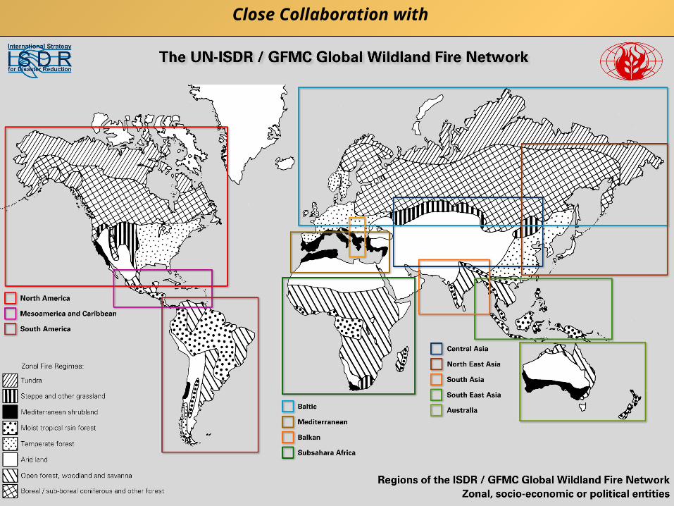
Close Collaboration with
New Drivers for GOFC-GOLD Fire• Changing World-Changing Fire Regimes – Economies and
Climate
• IPCC Evolution Requiring New Science and Data Sets– WGs 1,2,3 – Agency Emphasis on Impacts, Adaptation, Mitigation
• Changing Playing Field re. Satellite Observations
• Catastrophic Fire/On-Going Disasters – fire and forest
management
• International Environmental Conventions:– UNFCC – observations needs
– National Emissions Inventories and UN REDD
• GCOS Implementation Plan:– Establish international standards for fire observations
– Reliable methods for accuracy assessment
– Develop and apply validation protocols
• GEO & GEOSS work plan and tasks:– 2 tasks currently directly related to fire
– Updated tasks in 2009-2011 work plan
GEOSS societal benefits and land cover
ClimateLand change & GHG
emis.Water+energy
exchanges
ClimateLand change & GHG
emis.Water+energy
exchanges
WeatherLand–surface climate
int.Vegetation
characteristics
WeatherLand–surface climate
int.Vegetation
characteristics
HealthLand change / disease
vectors / boundary cond.
HealthLand change / disease
vectors / boundary cond.
DisastersFire monitoring
Land degradation assess.
DisastersFire monitoring
Land degradation assess.
AgricultureCultivation
pattern+forestryLand degradations
AgricultureCultivation
pattern+forestryLand degradations
EcosystemsChange environment
cond.Services + accounting
EcosystemsChange environment
cond.Services + accounting
EnergyBio-energy/biomassWind/hydro power
assess.
EnergyBio-energy/biomassWind/hydro power
assess.
WaterWater resources /
qualityLand+water use
pattern
WaterWater resources /
qualityLand+water use
pattern
BiodiversityEcosystem
characteristics Habitats +
fragmentation
BiodiversityEcosystem
characteristics Habitats +
fragmentation
Fire Relevant GEO TasksGEO 2009-2011 Work Plans
• DI-09-03b Implementation of a Fire Warning System at the Global Level– Develop a globally-coordinated warning system for fire,
including improved prediction capabilities, analysis tools and response support through sensors, information products and risk assessment models.
• CL-06-01c Key Climate Data from Satellite Systems– Establish actions securing the provision of key data for
climate studies and forecasting from satellite systems.
GOFC-Fire Response to New Drivers
International Coordination Initiatives
• Global Fire Assessment 2010
• Global Fire Early Warning System w. UN ISDR
• Global Geostationary Fire Network w. CEOS, GSICS
• ECVs, Validation and Reporting Protocols w. CEOS LPV
WG
• REDD Sourcebook – Fire
• Fire Data Continuity – VIIRS, Sentinel etc
• Improving Data Access – FIRMS >FAO
– GEONetcast Regional Access
– Land Direct Broadcast Coordination Group (ILDRCG)
Global Fire Assessment 2010• Science is documenting changing fire regimes and climate
projections show further changes likely • Increased availability of validated global fire products
means that a quantitative satellite-based Global Assessment now feasible (2000-2010)
• Product would provide a baseline for monitoring fire regime changes and contribute to IPCC WG 2
• Product could complement the 2010 UN FRA as did the Global Fire Management Assessment 2006 (narrative) for the 2005 FRA
• GOFC-GOLD Fire starting to coordinate the assessment with the regional fire networks – Thesaloniki Fire IT Meeting initial discussion– Need to develop appropriate data sets and metrics– Agree on National and regional reporting
Characterizing Global Fire - Metrics
Giglio et al., 2006, JGR
Season length from MODIS active fires (2000-2005)
Global Fire Early Warning System
• Proposal initially submitted to and endorsed by UN Interagency Strategy for Disaster Reduction (UN ISDR) in 2006
• Proposal presented at GOFC/WMO-Fire Risk Workshop in Edmonton in 2008
• Implementation strategy document under development by Bill DeGroot (NRCanada) and Johann Goldammer (GFMC)
• Funding proposals being developed and floated (e.g. ITTO, June 2009)
Opportunities for partners to join the Global Early Warning System for Wildland Fire
Coordinate with existing and upcoming systems of wildland fire early warning and monitoringhttp://www.fire.uni-freiburg.de/fwf/fwf.htm
Development Phase
Goal: Develop fire danger / susceptibility products
Satellite Active Fire Spectral Bands
Resolution IGFOV (km)
SSR (km)
Full Disk Coverage
3.9 m SaturationTemperature (K)
Minimum Fire Size at Equator (at 750 K) (hectares)
GOES-E/-WImager
1 visible3.9 and 10.7 m
1.04.0 (8.0)
0.572.3
3 hours >335 K (G-11)>335 K (G-12)
0.15
GOES-10 Imager(South America, 2006)
1 visible3.9 and 10.7 m
1.04.0 (8.0)
0.572.3
3 hours (Full Disk)15-min (SA)
~322 K (G-10) 0.15
MSG SEVIRI 1 HRV2 visible
1.6, 3.9 and 10.8 m
1.6 4.84.8
1.0 3.03.0
15 minutes ~335 K 0.22
FY-2C SVISSR(FY-2D, 2006)
1 visible,3.75 and 10.8 m
1.255.0
30 minutes ~330 K (?)
MTSAT-1R JAMI(HRIT)
1 visible3.7 and 10.8 m
1.04.0
1 hour ~320 K 0.15
INSAT-3D(4th Qtr, 2007)
1 vis, 1.6 m3.9 and 10.7 m
1.04.0
0.57 ?2.3 ?
30 minutes
GOMS Elektro N2MSU-G (2010)
3 visible1.6, 3.75 and 10.7 m
1.0 km4.0 km
30 minutes
COMS (2008) 1 visible3.9 and 10.7 m
1.0 km4.0 km
30 minutes
Satellite View Angle
80°
65°
Global GeostationaryActive Fire Monitoring
Capabilities
0-40-80-120-160 40 80 120
80
60
40
20
0
-20
-40
-60
-80
GOES-EGOES-W MSG COMS (116 or 128 E), MTSAT (140 E)
160
GOMS (76 E), INSAT (83 E), FY-2C (105 E)GOES-10
Goal: Establish a geostationary global fire network
partially implemented by NOAA
GTOS and Terrestrial ECVs
Part of GEO Task CL-06-01
Progress towards Fire Disturbance ECV
• GTOS (2008):Assessment of the Status of the Development of Standards for the Terrestrial ECVs – Fire disturbance (draft, 27 May 2009), GTOS-68 (in review)
• Action T32 Reanalyze historical fire measurements from
space (mod to low progress) • Action T33 Continuous fire measurements from space
(good progress) • Action T34 Apply common validation protocols to fire
measurements (mod to good progress)• Action T35 Fire products available worldwide (Mod to
good progress)
ECVs and associated activities need continuing refinement
ESA Climate Change InitiativeCreating ECVs
• Phase 1: Scientific user consultation and detailed specifications (2009>) - establish formal consultation mechanisms with the climate science programmes, including
setting up of the Climate Science Advisory Body - learn the lessons from analysis and assimilation of existing global data products - establish data access, Cal/Val and reprocessing requirements specific to ECVs - establish detailed data product, algorithm, and system performance specifications - initiate detailed requirements engineering and algorithm developments for ECVs - initiate data gathering and re-processing activities up to Level-1B/2
• Phase 2: Systems development and data products generation (2010>) - implement a series of high performance production systems for ECV generation - verify the correct implementation of selected retrieval algorithms and data models - initiate generation of large-scale long term ECV global data products - characterise & validate products before issue to the climate modelling community
• Phase 3: Assessment, Assimilation and feedback (2011>) - Trends assessment of all data products generated - Comparison with independent sources including in-situ - Use for initialization and evaluation of climate models - Identification of anomalies, biases, discontinuities, and cal/val improvements
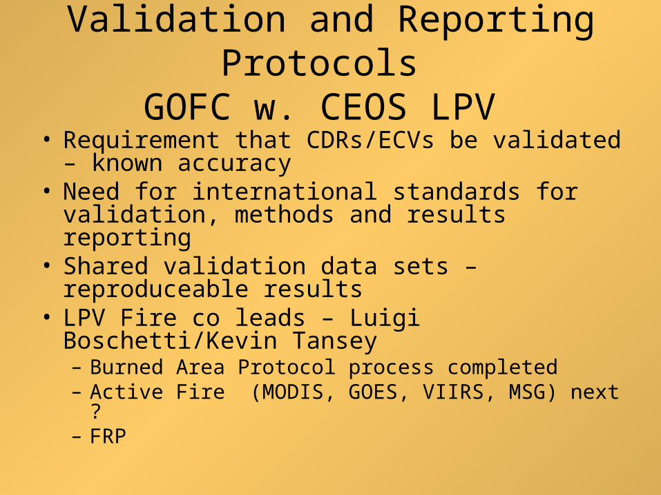
Validation and Reporting Protocols GOFC w. CEOS LPV
• Requirement that CDRs/ECVs be validated – known accuracy
• Need for international standards for validation, methods and results reporting
• Shared validation data sets – reproduceable results
• LPV Fire co leads – Luigi Boschetti/Kevin Tansey– Burned Area Protocol process completed– Active Fire (MODIS, GOES, VIIRS, MSG) next ?– FRP
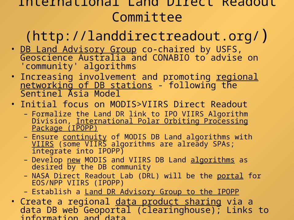
International Land Direct Readout Committee
(http://landdirectreadout.org/)• DB Land Advisory Group co-chaired by USFS,
Geoscience Australia and CONABIO to advise on 'community' algorithms
• Increasing involvement and promoting regional networking of DB stations - following the Sentinel Asia Model
• Initial focus on MODIS>VIIRS Direct Readout– Formalize the Land DR link to IPO VIIRS Algorithm Division,
International Polar Orbiting Processing Package (IPOPP)– Ensure continuity of MODIS DB Land algorithms with VIIRS (some
VIIRS algorithms are already SPAs; integrate into IPOPP)– Develop new MODIS and VIIRS DB Land algorithms as desired by
the DB community– NASA Direct Readout Lab (DRL) will be the portal for EOS/NPP
VIIRS (IPOPP)– Establish a Land DR Advisory Group to the IPOPP
• Create a regional data product sharing via a data DB web Geoportal (clearinghouse); Links to information and data
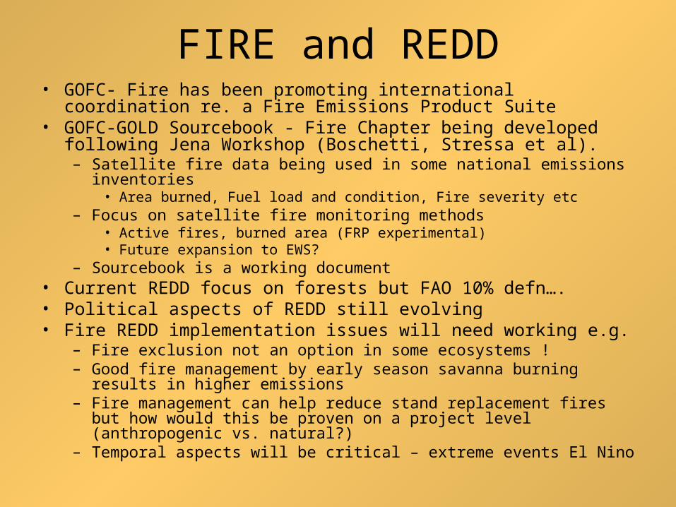
FIRE and REDD• GOFC- Fire has been promoting international coordination re. a Fire
Emissions Product Suite • GOFC-GOLD Sourcebook - Fire Chapter being developed following
Jena Workshop (Boschetti, Stressa et al). – Satellite fire data being used in some national emissions inventories
• Area burned, Fuel load and condition, Fire severity etc– Focus on satellite fire monitoring methods
• Active fires, burned area (FRP experimental)• Future expansion to EWS?
– Sourcebook is a working document • Current REDD focus on forests but FAO 10% defn….• Political aspects of REDD still evolving • Fire REDD implementation issues will need working e.g.
– Fire exclusion not an option in some ecosystems ! – Good fire management by early season savanna burning results in
higher emissions – Fire management can help reduce stand replacement fires but how
would this be proven on a project level (anthropogenic vs. natural?) – Temporal aspects will be critical – extreme events El Nino
Additional New Initiatives for
GOFC-FIRE to Consider • Continuity Products and Access from New and Next -
• Long-Term Satellite Fire Data Records – AVHRR Global 1km Re-analysis
• International Coordination of ECVs – Community consensus products ??? – Duplication of effort – competing products – At a minimum shared validation data sets (CEOS LPV)
• International Landsat-class Data Acquisition Coordination > increased coverage frequency
• Advise on REDD Fire Implementation issues• New GOFC Fire IT Leads – changing of the guard
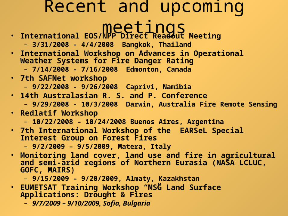
Recent and upcoming meetings• International EOS/NPP Direct Readout Meeting
– 3/31/2008 - 4/4/2008 Bangkok, Thailand• International Workshop on Advances in Operational Weather
Systems for Fire Danger Rating– 7/14/2008 - 7/16/2008 Edmonton, Canada
• 14th Australasian R. S. and P. Conference– 9/29/2008 - 10/3/2008 Darwin, Australia Fire Remote Sensing
• Redlatif Workshop – 10/22/2008 – 10/24/2008 Buenos Aires, Argentina
• 7th International Workshop of the EARSeL Special Interest Group on Forest Fires– 9/2/2009 – 9/5/2009, Matera, Italy
• Monitoring land cover, land use and fire in agricultural and semi-arid regions of Northern Eurasia (NASA LCLUC, GOFC, MAIRS) – 9/15/2009 – 9/20/2009, Almaty, Kazakhstan
• EUMETSAT Training Workshop “MSG Land Surface Applications: Drought & Fires”– 9/7/2009 – 9/10/2009, Sofia, Bulgaria
Continuing Challenges for GOFC-GOLD Fire
• Resources for Regional Networks – UN ?• Funding and implementation plan for EWS - ?• Support for the International Global Fire Assessment• Help users understand the different products
– Product inter-comparison and regional joint validation initiatives via the GOFC / UN Fire Networks
• Putting Fire higher on the agency observation priorities• Ensuring continued support for GOFC-GOLD Fire related
activities – need a fire project office?
• A Global Fire Monitoring System of Systems !?*!?