Buxar District, Bihar 1 District Survey Report of Minor Minerals, Buxar. Prepared in accordance with Para 7 (iii)(a) of S.O.141 (E) Dated 15th January 2016, As Amended on S.O. 3611 (E), dated 25 th July 2018 of Ministry of Environment, Forest and Climate Change Notification. GOVERNMENT OF BIHAR DISTRICT Buxar PREPARED BY sathi planners pvt. Ltd. Under the guidance of deiaa, BUXAr
Transcript
Buxar District, Bihar
1
District Survey Report of Minor Minerals, Buxar. Prepared in accordance with Para 7 (iii)(a) of S.O.141 (E)
Dated 15th January 2016, As Amended on S.O. 3611 (E), dated 25th July
2018 of
Ministry of Environment, Forest and Climate Change Notification.
GOVERNMENT OF BIHAR DISTRICT Buxar
PREPARED BY
sathi planners pvt. Ltd.
Under the guidance of deiaa, BUXAr
Buxar District, Bihar
2
CONTENT
Ch.No. Description Page No
Preamble 3
1 Introduction 5
1.1 Location and Geographical Area 5
1.2 Administrative Units 6
1.3 Connectivity 6
2 Overview of mining activity in the district 9
3 List of Mining lease in the district 10
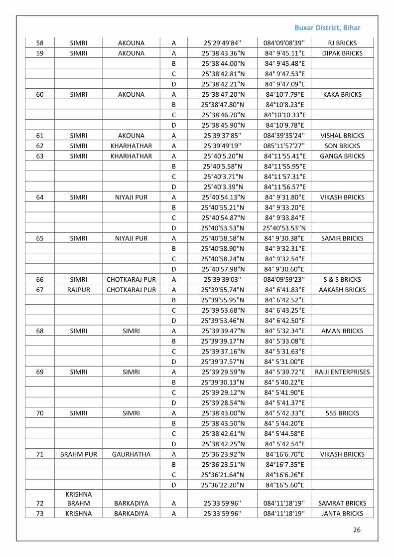
3.1 List of Kiln/Bhatta in the district as per department record 10
3.2 List of Kiln/Bhatta in the district as per field survey report 21
3.3 List of Sand ghat as per department list 35
3.4 List of Proposed sand ghat (Potential Area) 36
4 Detail of Royalty or Revenue received in last 3 years 40
5 Detail of Production of Sand or Bajri or minor mineral in last three
years
40
6 Process of Deposition of Sediments in the rivers of the District 41
7 General Profile of the District 47
8 Land Utilization Pattern in the district 59
9 Physiography of the District 60
10 Rainfall: Month Wise 61
11 Geology & Mineral wealth of the area 62
12 Additional Information 65
13 Disaster & Risk Management 66
14 Conclusion & Reference 70
Buxar District, Bihar
3
PREAMBLE
Keeping in view of experience gained in period of one decade, the MOEF&CC came out with
Environmental Impact Assessment Notification S.O.-1533(E) dated 14th Sept.2006. It has been made
mandatory to obtain environmental clearance for different kinds of development projects as listed
in Scheduled -1 of notification.
Further, pursuance of the order of Hon’ble Supreme Court Petition (C) No. 19628-19629 of 2009,
dated 27th Feb.2012 In the matter of Deepak Kumar etc., Vs State of Haryana and others etc., prior
environmental clearance has now become mandatory for Mining of Minor Minerals irrespective of
the area of Mining Lease.
And also in view of the Hon’ble National Green Tribunal, order dated the 13th Jan.2015 the matter
regarding Sand, Brick earth, & borrowed earth cutting for Road Construction has to take prior E.C.
For Mining Lease irrespective of the fact that whether the area involved is more or less than 5
hectares. They also suggested making a policy on E.C for sand including other minor minerals mining
Assessment Authority (DEIAA) & District level Expert Appraisal Committee (DEAC) has been formed
for Category –B2 Minor Minerals having area less than or equal to 5 ha.
Under 7(iii)(a) it was also suggested to prepare the district survey report for sand mining or river bed
mining and mining of other mineral as prescribed in appendix X. This has been modified vide S.O. No.-
3611(E) dated 25th July 2018.
In the present DSR of Buxar district no minor minerals other than sand mining or river bed sand and
brick earth has been described.
MOEF&CC in consultation with State Government has prepared Guidelines on Sustainable Sand &
other Minor minerals mining detailing the provisions on Environmental Clearance for cluster.
Creation of District Environmental Impact Assessment Authority (DEIAA) & proper monitoring of
Minor Minerals Mining using Information Technology to track the mineral out material from source
to destination.
DEAC will scrutinize and recommend the prior environmental clearance of Mining of Minor Mineral to
DEIAA on basis of District Survey report. This will be a model and guiding document which is a
compendium of available mineral resources, geographical setup, environmental and ecological set up
of the district and replenishment of minerals and is based on data of various departments, published
reports, Journal and websites. The District Survey report will form the basis for application for
environmental clearance, preparation of reports and appraisal of projects. District Survey Reports are
to be reviewed once in every five years as per statue, however the data bank of DSR can be updated, if
required.
In line with above guideline Chief Secretary of Government of Bihar issued Sand Policy vide
M/M/(Ba)04/13 – 2214 dated 27 -08-2013 subsequently Bihar Minor Mineral Rule 2017 was come
into force from 10-10-2017 but Hon’ble High Court has stayed the operation of Bihar Minor Mineral
Buxar District, Bihar
4
Rules 2017. The Hon’ble Court has further indicated that till such time, the earlier rules shall remain
operational.
In view of the situation arising out of the said order and in terms of the provisions under Rule 21(b)
and clause 17(c) of Form –D of Bihar Minor Mineral Concessions Role 1972 read with para 14 (ii) of
the Sand Policy -2013 the state Govt orders the following vide Principal Secretary oder no -7297/M
29-11-2017:-
State Govt. authorizes the Bihar State Mining Corporation, (came for existence from 22-09-2017) to
commence the business of trading in Minor Minerals in terms of the proposal submitted to the
State Govt. and duly approved by it on 1-10-2013 and the District Survey report will form the basis
for application for environmental clearance.
This order took effect from 01-12-2017
The Main objective of the preparation of District Survey Report is to ensure the following:-
1. Identification of Sand Ghats with geo references.
2. Identification of river silt with geo reference, which is being used for filling purposes.
3. Identification of brick kilns and bangla bhatthas with geo reference.
4. Identification of other mineral resources if available.
Buxar District, Bihar
5
1. INTRODUCTION
BUXAR AT A GLANCE:- 1.1 Location and Geographical Area The district Buxar came in existence on 17th March’ 1991. Agriculture is the main source of
sustenance for majority of population in the district. The district is rich in ground water resource,
which can be developed for irrigation purpose. The assured irrigation will increase the crop
production and improve the economic condition of people inhibiting the district.
The Sahabad district, has been sub-divided into three districts viz. Rohtas, Bhabua in the south and
Bhojpur district in the north. Buxar district was carved out of Bhojpur district on 17th March 1991
having Buxar town as district Head Quarter. Earlier it was a sub-division of Bhojpur district. The
Buxar district is situated between 25018’ to 25045’ latitudes north & 840 20’ to 840 40’ longitude
east. The district is included in the Survey of India toposheets number 72 C. Its geographical area
is 1624 Km2. The river Ganga forms a natural boundary in the north and northwest and the river
Karamnasa makes forms district boundary in the west-southwest. Bhabua & Rohtas districts in the
south, and Bhojpur district in the east forms its district boundary.
Buxar district consist of two Sub-divisions viz. Buxar Sadar and Dumraon stretching over an area of 1,62,380 hectares. The entire strip of land between the river Ganges on the north and the main line of the Eastern Railways on the South, is a low lying alluvial place. The region is considered to be the best wheat growing area in the the State.
The Ganges forms the northern boundary of the district. The river Karmansa joins the Ganges near Chousa.
The total population of district is 1,707,643, out of which only 9.64% live in urban regions, comprising the sum of 164,499 and remaining 90.36 % live in rural area, which counts to be
1,541,853 (2011 census).
This district is part of the Lower Ganga sub-basin of the Upper Ganga basin. The Ganga touches the district near Chausa. The river Ganga flows towards east parallel to the district boundary. The other rivers flowing from south to north, through the district, are the Noni and the Thora. Most of these are ephemeral. The river Karmanasa delimits the district in the west and southwest. It debouches in the river Ganga near Chausa. The river Karmanasa is an important for irrigation in the western part of the district. There are many lift irrigation schemes and side channels to carry overflowing river water to the field.
Buxar District, Bihar
6
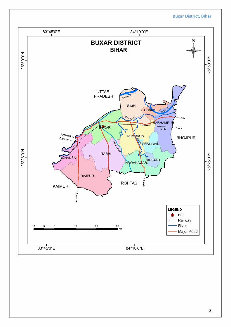
1.2 Administrative Units:- Buxar district comprises of 2 sub-division, 11 community development blocks, namely Buxar, Dumraon, Rajpur, Simri, Barhampur, Itarhi, Nawanagar, Chausa, Chaugain, Chakki, Kesath. There are 1102 villages in the district.
1.3 Connectivity Facilities in BUXAR District:-
The district has been fairly rich in road communication for a longtime. Some important roads of the district are the Varanasi road to Sasaram and the great road to Dumraon-Patna-Arrah-Buxar road, Behiya-Piro road, Dumraon-Nasriganj road, Sasaram-Bikramganj-Arrah road which connect the district with other neighboring cities or districts. Buxar, the district headquarters is on the the main line of the Eastern Railways. The Ganges is navigable all the year round and goods are transported to Kolkata on the east and places in Uttar Pradesh on the west through the rivers. Numerous express & local trains up and down cross daily through Buxar district Head-Quarter. Total length of railways is about one hundred kms. National highway NH 84 and State Highay 13, passess through the district.
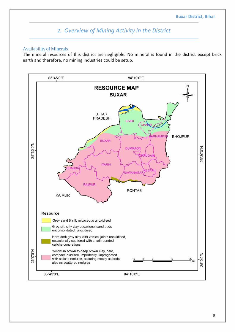
The mineral resources of this district are negligible. No mineral is found in the district except brick earth and therefore, no mining industries could be setup.
Buxar District, Bihar
10
3. List of Mining Lease in the District
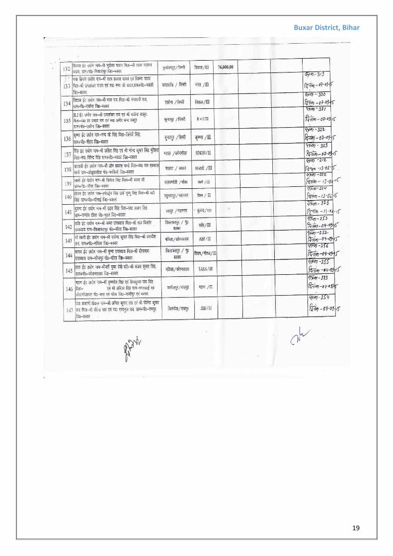
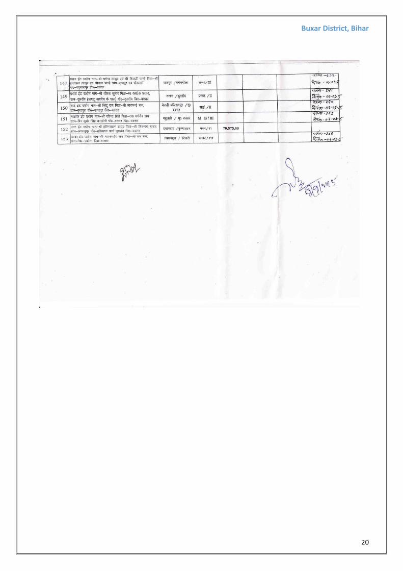
3.1 BRICK KILN/ BHATTA AS PER DEPARTMENTAL RECORD (Total – 153):
Buxar District, Bihar
11
Buxar District, Bihar
12
Buxar District, Bihar
13
Buxar District, Bihar
14
Buxar District, Bihar
15
Buxar District, Bihar
16
Buxar District, Bihar
17
Buxar District, Bihar
18
Buxar District, Bihar
19
Buxar District, Bihar
20
Buxar District, Bihar
21
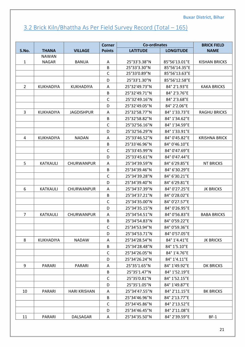
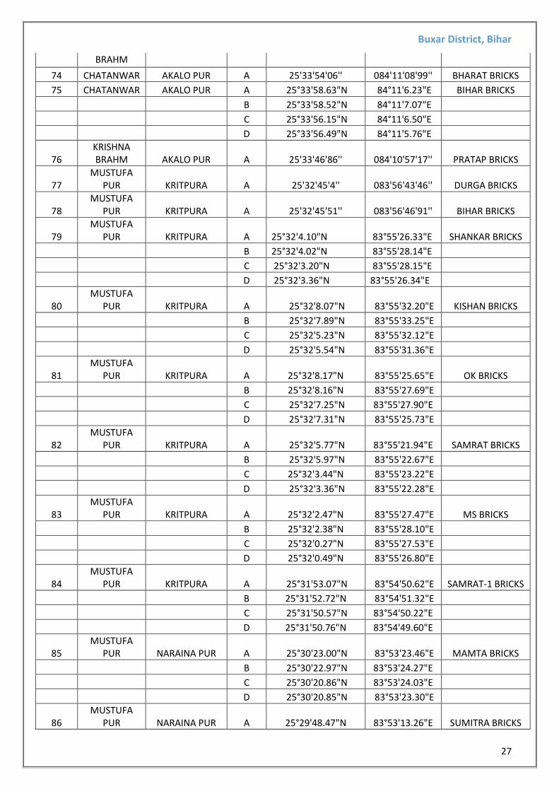
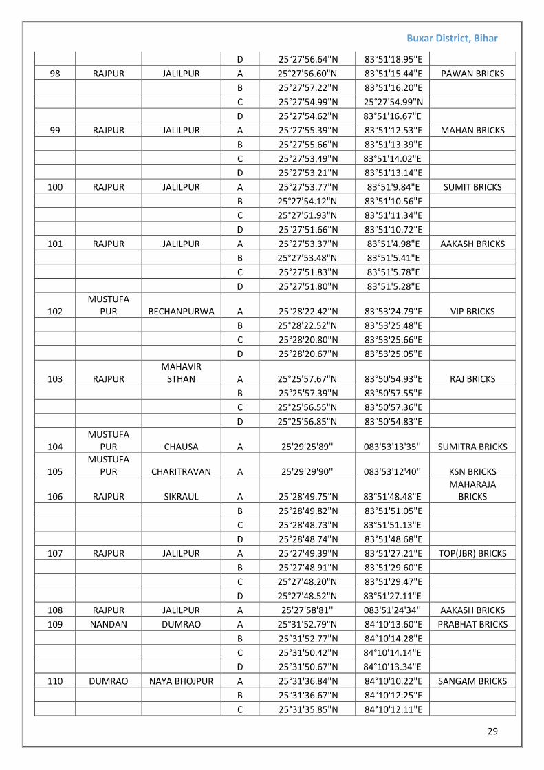
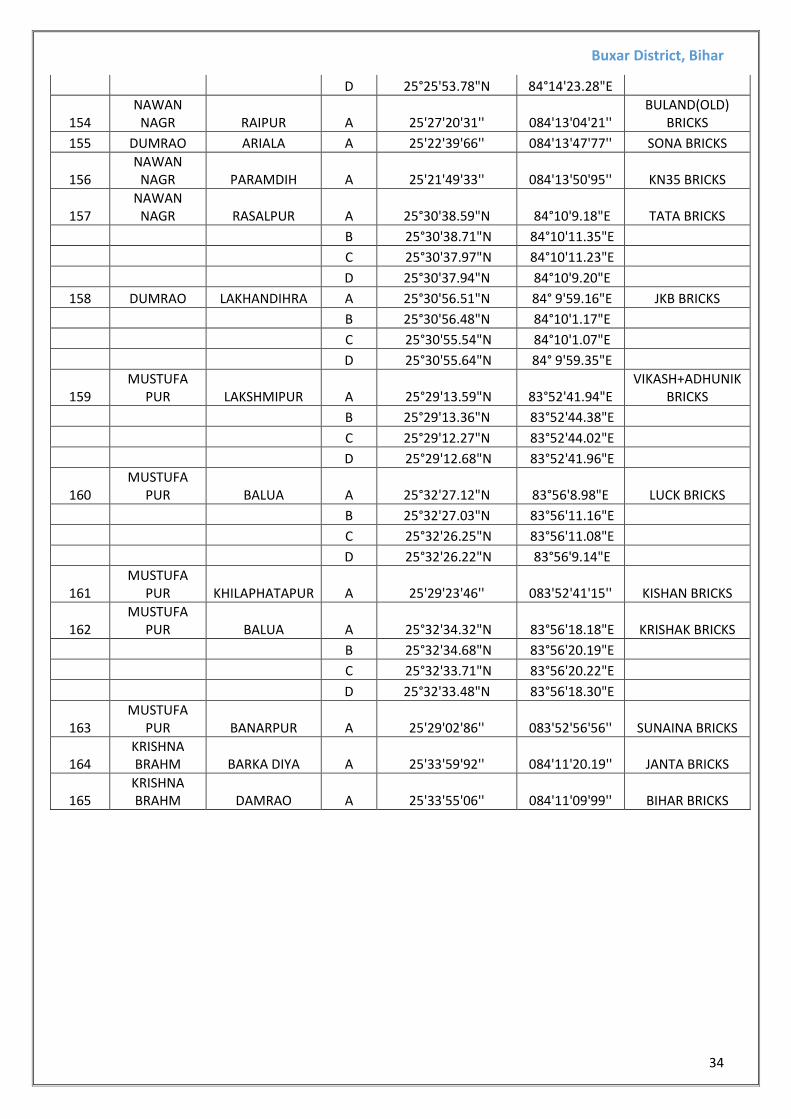
3.2 Brick Kiln/Bhattha As Per Field Survey Record (Total – 165)
S.No. THANA VILLAGE Corner Points
Co-ordinates BRICK FIELD NAME LATITUDE LONGITUDE
1 NAWAN NAGAR BANUA A 25°33'3.38"N 85°56'13.01"E KISHAN BRICKS
B 25°33'3.30"N 85°56'14.35"E
C 25°33'0.89"N 85°56'13.63"E
D 25°33'1.30"N 85°56'12.58"E
2 KUKHADIYA KUKHADIYA A 25°32'49.73"N 84° 2'1.93"E KAKA BRICKS
B 25°32'49.71"N 84° 2'3.76"E
C 25°32'49.16"N 84° 2'3.68"E
D 25°32'49.05"N 84° 2'2.06"E
3 KUKHADIYA JAGDISHPUR A 25°32'58.77"N 84° 1'33.73"E RAGHU BRICKS
B 25°32'58.82"N 84° 1'34.62"E
C 25°32'56.16"N 84° 1'34.59"E
D 25°32'56.29"N 84° 1'33.91"E
4 KUKHADIYA NADAN A 25°33'46.52"N 84° 0'45.82"E KRISHNA BRICK
B 25°33'46.96"N 84° 0'46.10"E
C 25°33'45.99"N 84° 0'47.69"E
D 25°33'45.61"N 84° 0'47.44"E
5 KATKAULI CHURWANPUR A 25°34'39.59"N 84° 6'29.85"E NT BRICKS
B 25°34'39.46"N 84° 6'30.29"E
C 25°34'39.28"N 84° 6'30.21"E
D 25°34'39.40"N 84° 6'29.81"E
6 KATKAULI CHURWANPUR A 25°34'37.39"N 84° 0'27.25"E JK BRICKS
B 25°34'37.21"N 84° 0'28.02"E
C 25°34'35.00"N 84° 0'27.57"E
D 25°34'35.15"N 84° 0'26.95"E
7 KATKAULI CHURWANPUR A 25°34'54.51"N 84° 0'56.83"E BABA BRICKS
B 25°34'54.83"N 84° 0'59.22"E
C 25°34'53.94"N 84° 0'59.36"E
D 25°34'53.71"N 84° 0'57.05"E
8 KUKHADIYA NADAW A 25°34'28.54"N 84° 1'4.41"E JK BRICKS
B 25°34'28.48"N 84° 1'5.10"E
C 25°34'26.05"N 84° 1'4.76"E
D 25°34'26.24"N 84° 1'4.11"E
9 PARARI PARARI A 25°35'1.65"N 84° 1'49.92"E DK BRICKS
B 25°35'1.47"N 84° 1'52.19"E
C 25°35'0.81"N 84° 1'52.15"E
D 25°35'1.05"N 84° 1'49.87"E
10 PARARI HARI KRISHAN A 25°34'47.55"N 84° 2'11.15"E BK BRICKS
B 25°34'46.96"N 84° 2'13.77"E
C 25°34'45.86"N 84° 2'13.52"E
D 25°34'46.45"N 84° 2'11.08"E
11 PARARI DALSAGAR A 25°34'35.50"N 84° 2'39.59"E BF-1
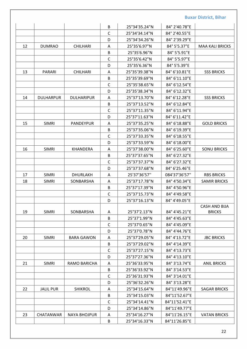
Buxar District, Bihar
22
B 25°34'35.24"N 84° 2'40.78"E
C 25°34'34.14"N 84° 2'40.55"E
D 25°34'34.26"N 84° 2'39.29"E
12 DUMRAO CHILHARI A 25°35'6.97"N 84° 5'5.37"E MAA KALI BRICKS
B 25°35'6.96"N 84° 5'5.91"E
C 25°35'6.42"N 84° 5'5.97"E
D 25°35'6.36"N 84° 5'5.39"E
13 PARARI CHILHARI A 25°35'39.38"N 84° 6'10.81"E SSS BRICKS
B 25°35'39.69"N 84° 6'11.10"E
C 25°35'38.65"N 84° 6'12.54"E
D 25°35'38.34"N 84° 6'12.32"E
14 DULHARPUR DULHARIPUR A 25°37'13.70"N 84° 6'12.28"E SSS BRICKS
B 25°37'13.52"N 84° 6'12.84"E
C 25°37'11.35"N 84° 6'11.94"E
D 25°37'11.63"N 84° 6'11.42"E
15 SIMRI PANDEYPUR A 25°37'35.25"N 84° 6'18.88"E GOLD BRICKS
B 25°37'35.06"N 84° 6'19.39"E
C 25°37'33.35"N 84° 6'18.55"E
D 25°37'33.59"N 84° 6'18.00"E
16 SIMRI KHANDERA A 25°37'38.00"N 84° 6'25.60"E SONU BRICKS
B 25°37'37.65"N 84° 6'27.32"E
C 25°37'37.37"N 84° 6'27.32"E
D 25°37'37.68"N 84° 6'25.46"E
17 SIMRI DHURLAKH A 25'37'36'57'' 084'37'36'57'' RBS BRICKS
18 SIMRI SONBARSHA A 25°37'17.78"N 84° 4'50.34"E SAMIR BRICKS
B 25°37'17.39"N 84° 4'50.96"E
C 25°37'15.73"N 84° 4'49.58"E
D 25°37'16.13"N 84° 4'49.05"E
19 SIMRI SONBARSHA A 25°37'2.13"N 84° 4'45.21"E CASH AND BIJA
BRICKS
B 25°37'1.99"N 84° 4'45.63"E
C 25°37'0.65"N 84° 4'45.09"E
D 25°37'0.78"N 84° 4'44.76"E
20 SIMRI BARA GAWON A 25°37'29.05"N 84° 4'13.72"E JBC BRICKS
B 25°37'29.02"N 84° 4'14.39"E
C 25°37'27.15"N 84° 4'13.73"E
D 25°37'27.36"N 84° 4'13.10"E
21 SIMRI RAMO BARICHA A 25°36'33.95"N 84° 3'13.74"E ANIL BRICKS
B 25°36'33.92"N 84° 3'14.53"E
C 25°36'31.93"N 84° 3'14.01"E
D 25°36'32.26"N 84° 3'13.28"E
22 JALIL PUR SHIKROL A 25°34'15.64"N 84°11'49.96"E SAGAR BRICKS
B 25°34'15.03"N 84°11'52.67"E
C 25°34'14.41"N 84°11'52.41"E
D 25°34'14.86"N 84°11'49.77"E
23 CHATANWAR NAYA BHOJPUR A 25°34'16.27"N 84°11'26.15"E VATAN BRICKS
B 25°34'16.33"N 84°11'26.85"E
Buxar District, Bihar
23
C 25°34'14.11"N 84°11'26.16"E
D 25°34'14.29"N 84°11'25.53"E
24 CHATANWAR NAYA BHOJPUR A 25°33'59.43"N 84°11'29.61"E NAYAK BRICKS
B 25°33'59.32"N 84°11'30.39"E
C 25°33'56.83"N 84°11'29.87"E
D 25°33'57.10"N 84°11'29.20"E
25 BARHAMPUR BARKA DHKAICH A 25°34'0.62"N 84°11'20.65"E PRADHAN BRICKS
B 25°33'59.98"N 84°11'23.47"E
C 25°33'59.26"N 84°11'23.25"E
D 25°33'59.96"N 84°11'20.43"E
26 BUXER KRITPURA A 25°32'30.56"N 83°55'53.75"E SAHARA BRICKS
B 25°32'30.70"N 83°55'55.55"E
C 25°32'30.08"N 83°55'55.64"E
D 25°32'29.90"N 83°55'53.81"E
27 BUXER KOTWA A 25°32'33.43"N 83°55'49.21"E VIP BRICKS
B 25°32'33.35"N 83°55'51.50"E
C 25°32'32.43"N 83°55'51.47"E
D 25°32'32.50"N 83°55'49.14"E
28 BUXER KRITPURA A 25°32'31.64"N 83°56'8.95"E GANGA BRICKS
B 25°32'31.65"N 83°56'11.30"E
C 25°32'30.90"N 83°56'11.39"E
D 25°32'30.89"N 83°56'9.06"E
29 BALU KMARPUR A 25°32'36.18"N 83°56'16.39"E SHANKAR BRICKS
B 25°32'36.17"N 83°56'18.40"E
C 25°32'35.40"N 83°56'18.49"E
D 25°32'35.52"N 83°56'16.47"E
30 BUXER MAHUARI A 25°32'49.23"N 83°56'41.34"E MAHABIR BICKS
B 25°32'49.37"N 83°56'43.43"E
C 25°32'48.61"N 83°56'43.54"E
D 25°32'48.47"N 83°56'41.51"E
31 BUXER KRITPURA A 25°32'48.07"N 83°56'46.42"E DURGA BRICKS
B 25°32'48.17"N 83°56'47.06"E
C 25°32'45.81"N 83°56'46.96"E
D 25°32'45.83"N 83°56'46.28"E
32 BUXER KRITPURA A 25°32'17.91"N 83°56'43.46"E OM SAI BRICKS
B 25°32'17.67"N 83°56'45.70"E
C 25°32'17.11"N 83°56'45.62"E
D 25°32'17.35"N 83°56'43.41"E
33 BUXER KHILAPHATAPUR A 25'32'32'17'' 083'56'07'23'' VIP BRICKS
34 DEVKULI BARHAMPUR A 25°36'35.05"N 84°18'45.43"E BBN BRICKS
B 25°36'35.18"N 84°18'46.18"E
C 25°36'33.33"N 84°18'46.17"E
D 25°36'33.44"N 84°18'45.47"E
35 DEVKULI DEVKULI A 25°36'38.87"N 84°19'23.74"E GOLDY BRICKS
B 25°36'38.54"N 84°19'25.72"E
C 25°36'37.99"N 84°19'25.55"E
Buxar District, Bihar
24
D 25°36'38.35"N 84°19'23.65"E
36 DEVKULI DEVKULI A 25°36'34.18"N 84°19'38.14"E BVN BRICKS
B 25°36'34.21"N 84°19'38.60"E
C 25°36'33.07"N 84°19'38.55"E
D 25°36'33.07"N 84°19'38.11"E
37 DEVKULI DEVKULI A 25°35'51.79"N 84°23'34.85"E PDN BRICKS
B 25°35'51.83"N 84°23'35.47"E
C 25°35'49.69"N 84°23'35.39"E
D 25°35'49.71"N 84°23'34.91"E
38 BRAHM PUR YOGIYA A 25°36'37.87"N 84°19'50.36"E BABA BRICKS
B 25°36'37.44"N 84°19'52.68"E
C 25°36'36.68"N 84°19'52.44"E
D 25°36'37.19"N 84°19'50.25"E
39 BRAHM PUR YOGIYA A 25°36'11.70"N 84°22'25.50"E NAMASTE BRICKS
B 25°36'11.46"N 84°22'27.65"E
C 25°36'10.66"N 84°22'27.57"E
D 25°36'11.01"N 84°22'25.50"E
40 BRAHM PUR YOGIYA A 25°36'8.19"N 84°22'39.25"E PDN BRICKS
B 25°36'7.65"N 84°22'40.86"E
C 25°36'7.12"N 84°22'40.60"E
D 25°36'7.67"N 84°22'39.01"E
41 BRAHM PUR YOGIYA A 25°36'32.10"N 84°15'39.78"E BABA BRICKS
B 25°36'32.14"N 84°15'41.84"E
C 25°36'31.52"N 84°15'41.83"E
D 25°36'31.51"N 84°15'39.97"E
42 BRAHM PUR YOGIYA A 25°36'20.09"N 84°15'39.62"E BHUSAN BRICKS
B 25°36'19.97"N 84°15'40.36"E
C 25°36'18.25"N 84°15'40.01"E
D 25°36'18.32"N 84°15'39.39"E
43 BRAHM PUR YOGIYA A 25°36'11.88"N 84°15'29.07"E PRADHAN BRICKS
B 25°36'11.31"N 84°15'31.60"E
C 25°36'10.61"N 84°15'31.18"E
D 25°36'11.16"N 84°15'28.94"E
44 KRISHNA BRAHM BARKA DIYA A 25°34'3.20"N 84°11'13.79"E SAMRAT BRICKS
B 25°34'3.09"N 84°11'14.57"E
C 25°34'1.01"N 84°11'14.22"E
D 25°34'1.26"N 84°11'13.47"E
45 KRISHNA BRAHM DAMRAO A 25°33'52.37"N 84°11'9.81"E BHARAT BRICKS
B 25°33'52.29"N 84°11'10.65"E
C 25°33'49.99"N 84°11'9.97"E
D 25°33'50.33"N 84°11'9.34"E
46 KRISHNA BRAHM DAMRAO A 25°33'45.70"N 84°10'56.93"E PRATAP BRICKS
B 25°33'45.89"N 84°10'59.32"E
C 25°33'45.23"N 84°10'59.42"E
Buxar District, Bihar
25
D 25°33'45.07"N 84°10'57.09"E
47 KRISHNA BRAHM AKALO PUR A 25'33'37'36'' 084'33'41'76'' PRATAP BRICKS
48 ARAAMPUR DUMRAO A 25°33'45.90"N 84°10'38.93"E KANAK BRICKS
B 25°33'45.58"N 84°10'41.47"E
C 25°33'44.87"N 84°10'41.39"E
D 25°33'45.06"N 84°10'38.87"E
49 KRISHNA BRAHM NAYA BHOJPUR A 25°34'5.67"N 84°10'34.68"E BHARTI BRICKS
B 25°34'5.56"N 84°10'35.42"E
C 25°34'3.27"N 84°10'35.04"E
D 25°34'3.45"N 84°10'34.33"E
50 DHKAITCH HATHELI PUR A 25°34'22.87"N 84°10'23.74"E SANKAR BRICKS
B 25°34'22.20"N 84°10'25.76"E
C 25°34'21.52"N 84°10'25.54"E
D 25°34'22.17"N 84°10'23.51"E
51 DEVKULI NAG PURA A 25°34'4.50"N 84°10'9.87"E BABA BRICKS
B 25°34'4.20"N 84°10'12.51"E
C 25°34'3.59"N 84°10'12.46"E
D 25°34'3.85"N 84°10'9.83"E
52 KRISHNA BRAHM JHKHA A 25°34'11.42"N 84° 9'36.52"E KISHAN BRICKS
B 25°34'11.06"N 84° 9'38.85"E
C 25°34'10.44"N 84° 9'38.66"E
D 25°34'10.75"N 84° 9'36.47"E
53 KRISHNA BRAHM BHOJPUR A 25°34'37.94"N 84° 9'43.14"E
PRAKASH & AMAR BRICKS
B 25°34'37.84"N 84° 9'45.36"E
C 25°34'37.07"N 84° 9'45.27"E
D 25°34'37.26"N 84° 9'43.10"E
54 KRISHNA BRAHM AKALO PUR A 25°33'38.66"N 84°11'0.01"E VATAN BRICKS
B 25°33'38.72"N 84°11'0.85"E
C 25°33'36.34"N 84°11'0.76"E
D 25°33'36.40"N 84°10'59.86"E
55 CHATANWAR AKOUNA A 25°34'4.71"N 84°11'36.94"E PRADHAN BRICKS
B 25°34'4.23"N 84°11'39.38"E
C 25°34'3.39"N 84°11'39.24"E
D 25°34'3.83"N 84°11'36.83"E
56 KRISHNA BRAHM BANSHI PUR A 25°34'2.08"N 84°11'58.42"E BHARAT BRICKS
B 25°34'1.83"N 84°12'1.15"E
C 25°34'1.17"N 84°12'1.04"E
D 25°34'1.41"N 84°11'58.39"E
57 SIMRI SOHAR A 25°38'52.79"N 84° 8'58.57"E KRISHNA BRICK
B 25°38'52.21"N 84° 9'0.38"E
C 25°38'51.59"N 84° 9'0.17"E
D 25°38'52.19"N 84° 8'58.37"E
Buxar District, Bihar
26
58 SIMRI AKOUNA A 25'29'49'84'' 084'09'08'39'' RJ BRICKS
59 SIMRI AKOUNA A 25°38'43.36"N 84° 9'45.11"E DIPAK BRICKS
B 25°38'44.00"N 84° 9'45.48"E
C 25°38'42.81"N 84° 9'47.53"E
D 25°38'42.21"N 84° 9'47.09"E
60 SIMRI AKOUNA A 25°38'47.20"N 84°10'7.79"E KAKA BRICKS
B 25°38'47.80"N 84°10'8.23"E
C 25°38'46.70"N 84°10'10.33"E
D 25°38'45.90"N 84°10'9.78"E
61 SIMRI AKOUNA A 25'39'37'85'' 084'39'35'24'' VISHAL BRICKS
62 SIMRI KHARHATHAR A 25'39'49'19'' 085'11'57'27'' SON BRICKS
63 SIMRI KHARHATHAR A 25°40'5.20"N 84°11'55.41"E GANGA BRICKS
B 25°40'5.58"N 84°11'55.95"E
C 25°40'3.71"N 84°11'57.31"E
D 25°40'3.39"N 84°11'56.57"E
64 SIMRI NIYAJI PUR A 25°40'54.13"N 84° 9'31.80"E VIKASH BRICKS
B 25°40'55.21"N 84° 9'33.20"E
C 25°40'54.87"N 84° 9'33.84"E
D 25°40'53.53"N 25°40'53.53"N
65 SIMRI NIYAJI PUR A 25°40'58.58"N 84° 9'30.38"E SAMIR BRICKS
B 25°40'58.90"N 84° 9'32.31"E
C 25°40'58.24"N 84° 9'32.54"E
D 25°40'57.98"N 84° 9'30.60"E
66 SIMRI CHOTKARAJ PUR A 25'39'39'03'' 084'09'59'23'' S & S BRICKS
67 RAJPUR CHOTKARAJ PUR A 25°39'55.74"N 84° 6'41.83"E AAKASH BRICKS
B 25°39'55.95"N 84° 6'42.52"E
C 25°39'53.68"N 84° 6'43.25"E
D 25°39'53.46"N 84° 6'42.50"E
68 SIMRI SIMRI A 25°39'39.47"N 84° 5'32.34"E AMAN BRICKS
B 25°39'39.17"N 84° 5'33.08"E
C 25°39'37.16"N 84° 5'31.63"E
D 25°39'37.57"N 84° 5'31.00"E
69 SIMRI SIMRI A 25°39'29.59"N 84° 5'39.72"E RAIJI ENTERPRISES
B 25°39'30.13"N 84° 5'40.22"E
C 25°39'29.12"N 84° 5'41.90"E
D 25°39'28.54"N 84° 5'41.37"E
70 SIMRI SIMRI A 25°38'43.00"N 84° 5'42.33"E 555 BRICKS
B 25°38'43.50"N 84° 5'44.20"E
C 25°38'42.61"N 84° 5'44.58"E
D 25°38'42.25"N 84° 5'42.54"E
71 BRAHM PUR GAURHATHA A 25°36'23.92"N 84°16'6.70"E VIKASH BRICKS
B 25°36'23.51"N 84°16'7.35"E
C 25°36'21.64"N 84°16'6.26"E
D 25°36'22.20"N 84°16'5.60"E
72 KRISHNA BRAHM BARKADIYA A 25'33'59'96'' 084'11'18'19'' SAMRAT BRICKS
73 KRISHNA BARKADIYA A 25'33'59'96'' 084'11'18'19'' JANTA BRICKS
Buxar District, Bihar
27
BRAHM
74 CHATANWAR AKALO PUR A 25'33'54'06'' 084'11'08'99'' BHARAT BRICKS
75 CHATANWAR AKALO PUR A 25°33'58.63"N 84°11'6.23"E BIHAR BRICKS
B 25°33'58.52"N 84°11'7.07"E
C 25°33'56.15"N 84°11'6.50"E
D 25°33'56.49"N 84°11'5.76"E
76 KRISHNA BRAHM AKALO PUR A 25'33'46'86'' 084'10'57'17'' PRATAP BRICKS
77 MUSTUFA
PUR KRITPURA A 25'32'45'4'' 083'56'43'46'' DURGA BRICKS
78 MUSTUFA
PUR KRITPURA A 25'32'45'51'' 083'56'46'91'' BIHAR BRICKS
79 MUSTUFA
PUR KRITPURA A 25°32'4.10"N 83°55'26.33"E SHANKAR BRICKS
B 25°32'4.02"N 83°55'28.14"E
C 25°32'3.20"N 83°55'28.15"E
D 25°32'3.36"N 83°55'26.34"E
80 MUSTUFA
PUR KRITPURA A 25°32'8.07"N 83°55'32.20"E KISHAN BRICKS
B 25°32'7.89"N 83°55'33.25"E
C 25°32'5.23"N 83°55'32.12"E
D 25°32'5.54"N 83°55'31.36"E
81 MUSTUFA
PUR KRITPURA A 25°32'8.17"N 83°55'25.65"E OK BRICKS
B 25°32'8.16"N 83°55'27.69"E
C 25°32'7.25"N 83°55'27.90"E
D 25°32'7.31"N 83°55'25.73"E
82 MUSTUFA
PUR KRITPURA A 25°32'5.77"N 83°55'21.94"E SAMRAT BRICKS
B 25°32'5.97"N 83°55'22.67"E
C 25°32'3.44"N 83°55'23.22"E
D 25°32'3.36"N 83°55'22.28"E
83 MUSTUFA
PUR KRITPURA A 25°32'2.47"N 83°55'27.47"E MS BRICKS
B 25°32'2.38"N 83°55'28.10"E
C 25°32'0.27"N 83°55'27.53"E
D 25°32'0.49"N 83°55'26.80"E
84 MUSTUFA
PUR KRITPURA A 25°31'53.07"N 83°54'50.62"E SAMRAT-1 BRICKS
B 25°31'52.72"N 83°54'51.32"E
C 25°31'50.57"N 83°54'50.22"E
D 25°31'50.76"N 83°54'49.60"E
85 MUSTUFA
PUR NARAINA PUR A 25°30'23.00"N 83°53'23.46"E MAMTA BRICKS
B 25°30'22.97"N 83°53'24.27"E
C 25°30'20.86"N 83°53'24.03"E
D 25°30'20.85"N 83°53'23.30"E
86 MUSTUFA
PUR NARAINA PUR A 25°29'48.47"N 83°53'13.26"E SUMITRA BRICKS
Buxar District, Bihar
28
B 25°29'48.65"N 83°53'16.19"E
C 25°29'47.71"N 83°53'16.20"E
D 25°29'47.66"N 83°53'13.45"E
87 MUSTUFA
PUR CHARITRAVAN A 25°29'29.53"N 83°53'8.80"E SUMITRA BRICKS
B 25°29'30.10"N 83°53'10.99"E
C 25°29'29.27"N 83°53'11.21"E
D 25°29'28.86"N 83°53'8.95"E
88 MUSTUFA
PUR NARAINA PUR A 25°29'38.45"N 83°53'22.06"E TRISUL BRICKS
B 25°29'39.11"N 83°53'23.84"E
C 25°29'38.33"N 83°53'24.27"E
D 25°29'37.87"N 83°53'22.21"E
89 RAJPUR SIKRAUL A 25°29'4.26"N 83°52'54.34"E PAWAN BRICKS
B 25°29'3.67"N 83°52'54.75"E
C 25°29'1.88"N 83°52'53.16"E
D 25°29'2.55"N 83°52'52.59"E
90 MUSTUFA
PUR BANNAR PUR A 25°28'44.49"N 83°52'41.02"E SASHANK BRICKS
B 25°28'44.15"N 83°52'41.63"E
C 25°28'42.15"N 83°52'40.13"E
D 25°28'42.47"N 83°52'39.51"E
91 MUSTUFA
PUR KRITPURA A 25'29'18'99'' 083'53'35'17'' KISHAN BRICKS
92 KHILAFT PUR NARAYAN PUR A 25°29'21.22"N 83°52'46.56"E VIP BRICKS
B 25°29'21.03"N 83°52'48.92"E
C 25°29'20.48"N 83°52'48.76"E
D 25°29'20.68"N 83°52'46.69"E
93 KHILAFT PUR NARAYAN PUR A 25°29'27.27"N 83°52'52.70"E BHAGYA BRICKS
B 25°29'27.17"N 83°52'54.51"E
C 25°29'26.46"N 83°52'54.47"E
D 25°29'26.75"N 83°52'52.63"E
94 KHILAFT PUR KHILAPHATAPUR A 25°29'37.77"N 83°52'43.45"E SASHI BRICKS
B 25°29'37.40"N 83°52'46.17"E
C 25°29'36.55"N 83°52'46.02"E
D 25°29'36.88"N 83°52'43.29"E
95 RAJPUR SIKRAUL A 25°28'27.30"N 83°51'37.34"E PRAGATI BRICKS
B 25°28'26.78"N 83°51'39.99"E
C 25°28'26.00"N 83°51'39.89"E
D 25°28'26.58"N 83°51'37.18"E
96 RAJPUR SIKRAUL A 25°28'2.57"N 3°51'31.52"E JBR BRICKS
B 25°28'2.14"N 83°51'33.84"E
C 25°28'1.39"N 83°51'33.70"E
D 25°28'1.71"N 83°51'31.46"E
97 RAJPUR JALILPUR A 25°27'58.02"N 83°51'21.15"E VIKASH BRICKS
B 25°27'57.37"N 83°51'21.62"E
C 25°27'56.07"N 83°51'19.47"E
Buxar District, Bihar
29
D 25°27'56.64"N 83°51'18.95"E
98 RAJPUR JALILPUR A 25°27'56.60"N 83°51'15.44"E PAWAN BRICKS
B 25°27'57.22"N 83°51'16.20"E
C 25°27'54.99"N 25°27'54.99"N
D 25°27'54.62"N 83°51'16.67"E
99 RAJPUR JALILPUR A 25°27'55.39"N 83°51'12.53"E MAHAN BRICKS
B 25°27'55.66"N 83°51'13.39"E
C 25°27'53.49"N 83°51'14.02"E
D 25°27'53.21"N 83°51'13.14"E
100 RAJPUR JALILPUR A 25°27'53.77"N 83°51'9.84"E SUMIT BRICKS
B 25°27'54.12"N 83°51'10.56"E
C 25°27'51.93"N 83°51'11.34"E
D 25°27'51.66"N 83°51'10.72"E
101 RAJPUR JALILPUR A 25°27'53.37"N 83°51'4.98"E AAKASH BRICKS
B 25°27'53.48"N 83°51'5.41"E
C 25°27'51.83"N 83°51'5.78"E
D 25°27'51.80"N 83°51'5.28"E
102 MUSTUFA
PUR BECHANPURWA A 25°28'22.42"N 83°53'24.79"E VIP BRICKS
B 25°28'22.52"N 83°53'25.48"E
C 25°28'20.80"N 83°53'25.66"E
D 25°28'20.67"N 83°53'25.05"E
103 RAJPUR MAHAVIR
STHAN A 25°25'57.67"N 83°50'54.93"E RAJ BRICKS
B 25°25'57.39"N 83°50'57.55"E
C 25°25'56.55"N 83°50'57.36"E
D 25°25'56.85"N 83°50'54.83"E
104 MUSTUFA
PUR CHAUSA A 25'29'25'89'' 083'53'13'35'' SUMITRA BRICKS
105 MUSTUFA
PUR CHARITRAVAN A 25'29'29'90'' 083'53'12'40'' KSN BRICKS
106 RAJPUR SIKRAUL A 25°28'49.75"N 83°51'48.48"E MAHARAJA
BRICKS
B 25°28'49.82"N 83°51'51.05"E
C 25°28'48.73"N 83°51'51.13"E
D 25°28'48.74"N 83°51'48.68"E
107 RAJPUR JALILPUR A 25°27'49.39"N 83°51'27.21"E TOP(JBR) BRICKS
B 25°27'48.91"N 83°51'29.60"E
C 25°27'48.20"N 83°51'29.47"E
D 25°27'48.52"N 83°51'27.11"E
108 RAJPUR JALILPUR A 25'27'58'81'' 083'51'24'34'' AAKASH BRICKS
109 NANDAN DUMRAO A 25°31'52.79"N 84°10'13.60"E PRABHAT BRICKS
B 25°31'52.77"N 84°10'14.28"E
C 25°31'50.42"N 84°10'14.14"E
D 25°31'50.67"N 84°10'13.34"E
110 DUMRAO NAYA BHOJPUR A 25°31'36.84"N 84°10'10.22"E SANGAM BRICKS
B 25°31'36.67"N 84°10'12.25"E
C 25°31'35.85"N 84°10'12.11"E
Buxar District, Bihar
30
D 25°31'36.14"N 84°10'10.17"E
111 DUMRAO LAKHANDIHRA A 25°31'8.37"N 84° 9'57.58"E SAHARA BRICKS
B 25°31'7.15"N 84° 9'58.65"E
C 25°31'5.89"N 84° 9'57.39"E
D 25°31'7.37"N 84° 9'56.29"E
112 KORAN SARAI KARUAJ A 25°30'32.13"N 84° 9'44.66"E CHANDAN BRICKS
B 25°30'32.47"N 84° 9'46.96"E
C 25°30'31.73"N 84° 9'47.18"E
D 25°30'31.35"N 84° 9'45.06"E
113 SARIYA KOPUA BANJA A 25°30'45.75"N 84° 9'20.21"E BHAWAN BRICKS
B 25°30'45.85"N 84° 9'22.40"E
C 25°30'45.19"N 84° 9'22.42"E
D 25°30'45.01"N 84° 9'20.29"E
114 NAVANAGAR PARARI A 25°30'11.42"N 84° 9'53.41"E BHAWAN BRICKS
B 25°30'11.46"N 84° 9'54.18"E
C 25°30'9.41"N 84° 9'54.34"E
D 25°30'9.45"N 84° 9'53.61"E
115 KORAN SARAI MUGAON A 25°29'2.71"N 84°10'35.75"E BADAL BRICKS
B 25°29'3.32"N 84°10'37.82"E
C 25°29'2.37"N 84°10'38.25"E
D 25°29'1.91"N 84°10'36.07"E
116 KORAN SARAI MATTHILA A 25°28'52.17"N 84°10'32.49"E MAHAL BRICKS
B 25°28'51.72"N 84°10'34.74"E
C 25°28'50.74"N 84°10'34.43"E
D 25°28'51.24"N 84°10'32.15"E
117 KORAN SARAI MATTHILA A 25°28'37.16"N 84°10'9.64"E ABF BRICKS
B 25°28'36.24"N 84°10'10.63"E
C 25°28'35.64"N 84°10'9.68"E
D 25°28'36.36"N 84°10'8.95"E
118 KORAN SARAI MATTHILA A 25°28'25.37"N 84°10'27.34"E TARA BRICKS
B 25°28'25.18"N 84°10'29.93"E
C 25°28'24.25"N 84°10'29.64"E
D 25°28'24.42"N 84°10'27.18"E
119 KORAN SARAI DAKHINAO A 25°28'17.87"N 84°10'11.67"E SBF BRICKS
B 25°28'17.58"N 84°10'14.00"E
C 25°28'16.78"N 84°10'13.72"E
D 25°28'17.04"N 84°10'11.48"E
120 NAWAN
NAGR KESATTH A 25°27'57.41"N 84°10'40.33"E SBF(SONI) BRICKS
B 25°27'57.61"N 84°10'42.87"E
C 25°27'56.72"N 84°10'42.96"E
D 25°27'56.65"N 84°10'40.60"E
121 NAWAN
NAGR RMA PUR A 25°27'4.72"N 84°13'13.49"E BULAND BRICKS
B 25°27'3.96"N 84°13'15.54"E
C 25°27'3.27"N 84°13'15.32"E
D 25°27'4.06"N 84°13'13.06"E
Buxar District, Bihar
31
122 NAWAN
NAGR BAIZNATH PUR A 25°26'23.25"N 84°14'6.60"E SHANKAR BRICKS
B 25°26'23.24"N 84°14'7.36"E
C 25°26'21.08"N 84°14'6.76"E
D 25°26'21.19"N 84°14'6.04"E
123 NAWAN
NAGR RAGHUNATH
PUR A 25°26'23.63"N 84°14'35.61"E SHIVAM BRICKS
B 25°26'23.42"N 84°14'36.14"E
C 25°26'21.64"N 84°14'35.38"E
D 25°26'21.86"N 84°14'34.78"E
124 MURAR CHAUGAI A 25°27'55.94"N 84°14'12.16"E SAJAN BRICKS
B 25°27'55.99"N 84°14'12.89"E
C 25°27'54.31"N 84°14'12.56"E
D 25°27'54.45"N 84°14'11.87"E
125 MURAR CHAUGAI A 25°28'10.62"N 84°13'48.47"E T+N BRICKS
B 25°28'10.41"N 84°13'49.21"E
C 25°28'8.17"N 84°13'48.50"E
D 25°28'8.41"N 84°13'47.75"E
126 MURAR CHAUGAI A 25°28'4.37"N 84°13'39.35"E ROSHAN BRICKS
B 25°28'4.21"N 84°13'39.95"E
C 25°28'2.28"N 84°13'39.31"E
D 25°28'2.56"N 84°13'38.66"E
127 KORAN SARAI SARAIYA A 25°28'36.91"N 84°11'21.19"E VIKASH BRICKS
B 25°28'36.94"N 84°11'21.83"E
C 25°28'34.70"N 84°11'21.56"E
D 25°28'34.86"N 84°11'20.92"E
128 KORAN SARAI KORAN SARAI A 25°28'4.38"N 84°11'48.04"E VIVEK BRICKS
B 25°28'4.30"N 84°11'48.57"E
C 25°28'2.28"N 84°11'48.23"E
D 25°28'2.41"N 84°11'47.68"E
129 NAWAN
NAGR RAIPUR A 25°27'24.30"N 84°13'6.82"E BHARAT BRICKS
B 25°27'24.43"N 84°13'7.54"E
C 25°27'21.99"N 84°13'7.13"E
D 25°27'22.07"N 84°13'6.53"E
130 MURAR MURAR A 25'27'08'82'' 084'13'18'73'' BULAND BRICKS
131 NAWAN
NAGR ADHAR A 25°26'3.63"N 84°11'7.66"E NTR BRICKS
B 25°26'3.46"N 84°11'10.35"E
C 25°26'2.56"N 84°11'10.14"E
D 25°26'2.84"N 84°11'7.74"E
132 NAWAN
NAGR NAWAN NAGAR A 25°23'40.51"N 84°12'43.76"E RK BRICKS
B 25°23'39.65"N 84°12'45.81"E
C 25°23'38.92"N 84°12'45.37"E
D 25°23'39.72"N 84°12'43.45"E
133 NAWAN
NAGR BHAILI A 25°23'33.93"N 84°12'59.87"E PK BRICKS
Buxar District, Bihar
32
B 25°23'34.09"N 84°13'0.49"E
C 25°23'32.08"N 84°13'0.88"E
D 25°23'31.91"N 84°13'0.26"E
134 NAWAN
NAGR BHAILI A 25°23'7.83"N 84°13'23.22"E GOLD BRICKS
B 25°23'8.25"N 84°13'23.74"E
C 25°23'6.21"N 84°13'25.35"E
D 25°23'5.76"N 84°13'24.75"E
135 NAWAN
NAGR TURAUKHAS A 25°22'39.59"N 84°13'42.23"E KISHAN (KN)
BRICKS
B 25°22'39.69"N 84°13'42.99"E
C 25°22'36.90"N 84°13'42.51"E
D 25°22'37.12"N 84°13'41.72"E
136 MURAR NOKHPUR A 25°21'57.98"N 84°13'54.13"E TATA BRICKS
B 25°21'58.09"N 84°13'54.87"E
C 25°21'55.30"N 84°13'54.77"E
D 25°21'55.33"N 84°13'53.85"E
137 NAWAN
NAGR GUJJADI A 25°21'45.81"N 84°13'42.12"E SONA BRICKS
B 25°21'45.20"N 84°13'44.48"E
C 25°21'44.45"N 84°13'44.24"E
D 25°21'45.08"N 84°13'41.76"E
138 NAWAN
NAGR PARAMDI A 25°20'48.73"N 84°13'46.48"E DHIRAJ BRICKS
B 25°20'48.21"N 84°13'49.02"E
C 25°20'47.61"N 84°13'48.89"E
D 25°20'48.05"N 84°13'46.29"E
139 NAWAN
NAGR PARAMDI A 25°21'0.00"N 84°13'39.52"E KAMAL BRICKS
B 25°20'59.68"N 84°13'40.22"E
C 25°20'57.32"N 84°13'39.46"E
D 25°20'57.53"N 84°13'38.84"E
140 NAWAN
NAGR DASIYOV A 25°21'20.69"N 84°12'49.87"E LAXMI BRICKS
B 25°21'20.26"N 84°12'52.13"E
C 25°21'19.54"N 84°12'51.79"E
D 25°21'19.91"N 84°12'49.75"E
141 NAWAN
NAGR TURAUKHAS A 25°22'10.86"N 84°13'25.09"E SONA BRICKS
B 25°22'10.70"N 84°13'25.74"E
C 25°22'8.12"N 84°13'25.11"E
D 25°22'8.22"N 84°13'24.43"E
142 BAGEN BHADWAR A 25°22'33.52"N 84°13'27.85"E BHAWANI BRICKS
B 25°22'33.20"N 84°13'29.82"E
C 25°22'32.38"N 84°13'29.72"E
D 25°22'32.85"N 84°13'27.62"E
143 NAWAN
NAGR NAWAN NAGAR A 25°22'50.62"N 84°13'4.19"E TATA BRICKS
Buxar District, Bihar
33
B 25°22'50.74"N 84°13'5.18"E
C 25°22'48.26"N 84°13'5.56"E
D 25°22'48.23"N 84°13'4.58"E
144 NAWAN
NAGR NAWAN NAGAR A 25°23'2.81"N 84°12'58.78"E BABA BRICKS
B 25°23'2.97"N 84°13'1.13"E
C 25°23'2.17"N 84°13'1.17"E
D 25°23'2.14"N 84°12'58.90"E
145 MUSTUFA
PUR JASO A 25'34'33'25'' 083'59'56'57'' ND BRICKS
146 NAWAN
NAGR TURAUKHAS A 25°21'46.09"N 84°12'50.85"E KISHAN/BABA
BRICKS
B 25°21'45.82"N 84°12'51.69"E
C 25°21'43.46"N 84°12'50.69"E
D 25°21'43.95"N 84°12'49.84"E
147 NAWAN
NAGR CHANCHUA A 25°25'9.64"N 84°13'51.03"E PKS/KN56 BRICKS
B 25°25'9.41"N 84°13'52.07"E
C 25°25'7.14"N 84°13'51.70"E
D 25°25'6.96"N 84°13'50.72"E
148 NAWAN
NAGR CHANCHUA A 25°20'54.24"N 84°13'34.27"E VIP/DHIRAJ
BRICKS
B 25°20'53.77"N 84°13'36.34"E
C 25°20'52.93"N 84°13'36.16"E
D 25°20'53.45"N 84°13'34.05"E
149 NAWAN
NAGR ARIAO A 25°21'10.22"N 84°13'42.46"E SHIVSHAKTI
BRICKS
B 25°21'10.12"N 84°13'43.21"E
C 25°21'8.12"N 84°13'42.65"E
D 25°21'8.23"N 84°13'42.01"E
150 MURAR NAWADI A 25°28'8.44"N 84°11'35.79"E MADHU/KUMAR
BRICKS
B 25°28'8.25"N 84°11'37.97"E
C 25°28'7.58"N 84°11'38.05"E
D 25°28'7.75"N 84°11'35.69"E
151 NAWAN
NAGR SHIVPUR A 25°28'13.92"N 84°13'54.15"E SAMRAT BRICKS
B 25°28'13.79"N 84°13'54.93"E
C 25°28'12.14"N 84°13'54.59"E
D 25°28'12.15"N 84°13'53.91"E
152 NAWAN
NAGR PALHDI A 25°26'36.14"N 84°14'7.43"E JHANKI/STM
BRICKS
B 25°26'36.10"N 84°14'8.06"E
C 25°26'33.89"N 84°14'7.73"E
D 25°26'34.04"N 84°14'7.03"E
153 NAWAN
NAGR KESATTH A 25°25'55.82"N 84°14'22.85"E BHARAT BRICKS
B 25°25'56.05"N 84°14'23.43"E
C 25°25'53.97"N 84°14'23.94"E
Buxar District, Bihar
34
D 25°25'53.78"N 84°14'23.28"E
154 NAWAN
NAGR RAIPUR A 25'27'20'31'' 084'13'04'21'' BULAND(OLD)
BRICKS
155 DUMRAO ARIALA A 25'22'39'66'' 084'13'47'77'' SONA BRICKS
156 NAWAN
NAGR PARAMDIH A 25'21'49'33'' 084'13'50'95'' KN35 BRICKS
157 NAWAN
NAGR RASALPUR A 25°30'38.59"N 84°10'9.18"E TATA BRICKS
B 25°30'38.71"N 84°10'11.35"E
C 25°30'37.97"N 84°10'11.23"E
D 25°30'37.94"N 84°10'9.20"E
158 DUMRAO LAKHANDIHRA A 25°30'56.51"N 84° 9'59.16"E JKB BRICKS
B 25°30'56.48"N 84°10'1.17"E
C 25°30'55.54"N 84°10'1.07"E
D 25°30'55.64"N 84° 9'59.35"E
159 MUSTUFA
PUR LAKSHMIPUR A 25°29'13.59"N 83°52'41.94"E VIKASH+ADHUNIK
BRICKS
B 25°29'13.36"N 83°52'44.38"E
C 25°29'12.27"N 83°52'44.02"E
D 25°29'12.68"N 83°52'41.96"E
160 MUSTUFA
PUR BALUA A 25°32'27.12"N 83°56'8.98"E LUCK BRICKS
B 25°32'27.03"N 83°56'11.16"E
C 25°32'26.25"N 83°56'11.08"E
D 25°32'26.22"N 83°56'9.14"E
161 MUSTUFA
PUR KHILAPHATAPUR A 25'29'23'46'' 083'52'41'15'' KISHAN BRICKS
162 MUSTUFA
PUR BALUA A 25°32'34.32"N 83°56'18.18"E KRISHAK BRICKS
B 25°32'34.68"N 83°56'20.19"E
C 25°32'33.71"N 83°56'20.22"E
D 25°32'33.48"N 83°56'18.30"E
163 MUSTUFA
PUR BANARPUR A 25'29'02'86'' 083'52'56'56'' SUNAINA BRICKS
164 KRISHNA BRAHM BARKA DIYA A 25'33'59'92'' 084'11'20.19'' JANTA BRICKS
165 KRISHNA BRAHM DAMRAO A 25'33'55'06'' 084'11'09'99'' BIHAR BRICKS
Buxar District, Bihar
35
3.3 LIST OF EXISTING SAND GHATS:
Buxar District, Bihar
36
3.4 LIST OF PROPOSED SAND GHATS (POTENTIAL AREA)
SL NO
BLOCK OFFICE(B
DO) MOUZA BLOCK
AREA IN HEC
T
NAME OF
RIVER
SL.NO
LATITUDE LONGITUDE
1 BUXAR LAROPUR BLOCK - A 24 GANGA
A 25°33'5.25"N 83°55'51.27"E
B
25°33'20.90"N 83°55'42.53"E
C
25°33'27.09"N 83°55'56.26"E
D
25°33'12.81"N 83°56'6.29"E
2 BUXAR THORAGANG
BARAR BLOCK - B 24.6 GANGA
A
25°33'31.80"N 83°56'9.38"E
B
25°33'18.53"N 83°56'17.27"E
C
25°33'28.16"N 83°56'34.24"E
D
25°33'39.89"N 83°56'27.01"E
3 SIMRI Pratppur Noubarar
BLOCK - C 24.7 GANGA
A
25°42'19.34"N 84° 5'12.44"E
B
25°42'10.60"N 84° 5'32.64"E
C
25°41'59.74"N 84° 5'26.54"E
D 25°42'6.84"N 84° 5'6.07"E
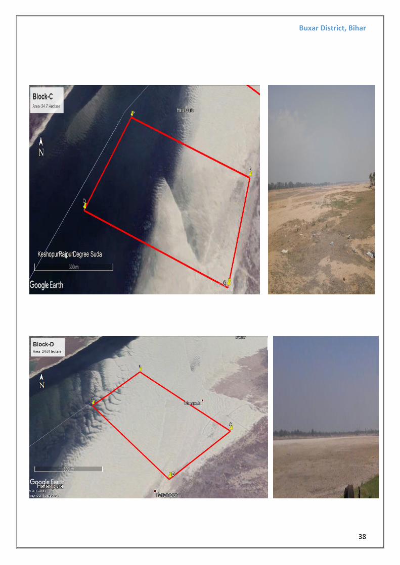
4 SIMRI TARANPUR BLOCK-D 24.6 GANGA
A 25°42'29.50"N 84° 5'52.03"E
B
25°42'21.49"N 84° 5'40.63"E
C
25°42'34.99"N 84° 5'25.79"E
D
25°42'44.48"N 84° 5'34.70"E
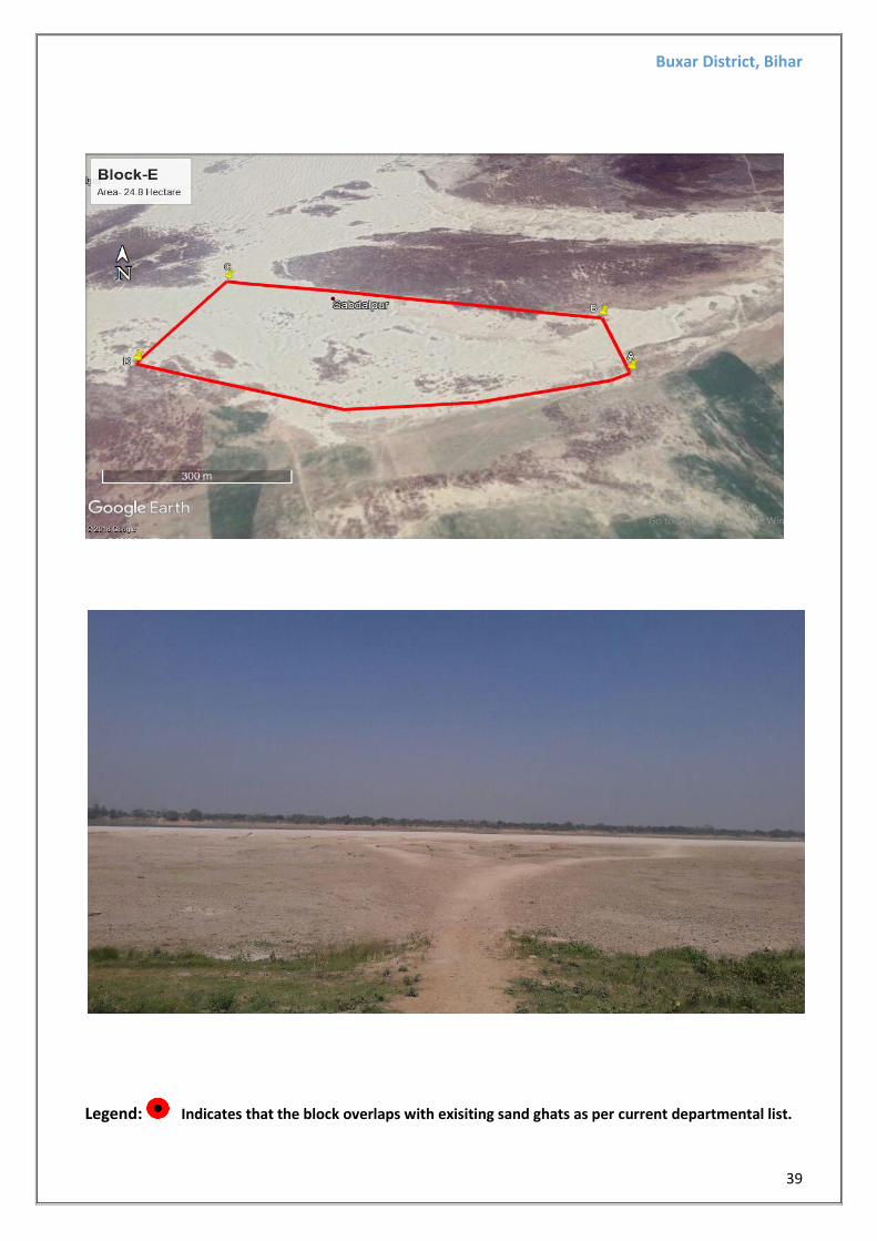
5 SIMRI SABDALPUR BLOCK-E 24.8 GANGA
A
25°42'33.11"N 84° 6'49.10"E
B
25°42'38.56"N 84° 6'48.10"E
C
25°42'42.75"N 84° 6'19.78"E
D
25°42'33.99"N 84° 6'16.16"E
Note: (i) These sand blocks were identified on the basis of geological studies carried out through
field observation, and also includes sand ghats already auctioned by department. Thus, it is
recommended to get those blocks verified with concerned authorities before opting for any
statutory clearances.
(ii) Availability of sand in the aforementioned sand blocks may vary based on the
replenishment.
Buxar District, Bihar
37
GOOGLE KML IMAGES AND SITE PHOTOGRAPHS FOR PROPOSED SAND GHATS:
Buxar District, Bihar
38
Buxar District, Bihar
39
Legend: Indicates that the block overlaps with exisiting sand ghats as per current departmental list.
Buxar District, Bihar
40
4. Detail of Royalty or Revenue Received in last three years
Year wise Total Revenue Collection (in Rupees Lakhs)
S.N0 District 2014-15 2015-16 2016-17 2017-18 till Dec.17
1 Baxar 426.65 426.55 499.55 463.95
5. Details of Production of Sand Or Bajri or Minor Mineral In Last
Three Years
Sl. No. Year Production
1 2015-16 NA
2 2016-17 NA
3 2017-18 NA
Buxar District, Bihar
41
6. Process of Deposition of Sediments In The Rivers of The District
Replenishment of Sand :-
The deposition in a river bed is more pronounced during rainy season although the quantum of deposition varies from stream to stream depending upon numbers of factors such as catchment, lithology, discharge, river profile and geomorphology of the river course where annual deposition is one meters, but it is noticed that during flood season whole of the pit so excavated is completely filled up and as such the excavated area is replenished with new harvest of minerals.
In order to calculate the mineral deposits in the stream beds, the mineral constituents have been categorized as clay, silt, sand, bajri and boulder. However, during present calculation, the waste material i.e silt which vary from 10 to 20% in different streams has also been included in the total production. Further the Survey of India Topo-Sheets are used as base map to know the extent of river course. The mineral reserves have been calculated only upto 1.00 meter depth although there are some portions in the river beds such as channel bars, point bars and central islands where the annual deposition is raising the level of river bed thus causing shifting of the rivers towards banks resulting in to cutting of banks and at such locations, removal of this material upto the bed level is essential to control the river flow in its central part to check the bank cutting. While calculating the mineral potentials, the mineral deposits lying in the sub- tributaries of that particular stream/river has not been taken into consideration. Since these mineral deposits are adding annually.
Surface runoff
Also known as overland flow is the flow of water that occurs when excess storm water, melt water, or other sources flows over the Earth's surface. This might occur because soil is saturated to full capacity, because rain arrives more quickly than soil can absorb it, or because impervious areas (roofs and pavement) send their runoff to surrounding soil that cannot absorb all of it. Surface runoff is a major component of the water cycle. It is the primary agent in soil erosion by water.
Runoff that occurs on the ground surface before reaching a channel is also called a nonpoint source. If a nonpoint source contains man-made contaminants, or natural forms of pollution (such as rotting leaves) the runoff is called nonpoint source pollution. A land area which produces runoff that drains to a common point is called a drainage basin. When runoff flows along the ground, it can pick up soil contaminants including petroleum, pesticides, or fertilizers that become discharge or nonpoint source pollution.
In addition to causing water erosion and pollution, surface runoff in urban areas is a primary cause of urban flooding which can result in property damage, damp and mold in basements, and street flooding.
Surface runoff can cause erosion of the Earth's surface; eroded material may be deposited a considerable distance away.
There are four main types of soil erosion by water:
• splash erosion,
• sheet erosion,
• rill erosion,
• gully erosion.
Splash erosion is the result of mechanical collision of raindrops with the soil surface: soil particles which are dislodged by the impact then move with the surface runoff.
Sheet erosion is the overland transport of sediment by runoff without a well-defined channel.
Soil surface roughness causes may cause runoff to become concentrated into narrower flow paths: as these incise, the small but well-defined channels which are formed are known as rills. These channels can be as small as one centimeter wide or as large as several meters.
If runoff continue to incise and enlarge rills, they may eventually grow to become gullies.
Gully erosion can transport large amounts of eroded material in a small time period.
Soil erosion by water on intensively-tilled farmland.
Reduced crop productivity usually results from erosion, and these effects are studied in the field of soil conservation. The soil particles carried in runoff vary in size from about .001 millimeter to 1.0 millimeter in diameter. Larger particles settle over short transport distances, whereas small particles can be carried over long distances suspended in the water column.
There are many sediment transport equations which are suitable for use in the prediction of the replenishment rate of rivers/ watershed. Some of the Famous sediment transport equations are: ‐
DANDY ‐ BOLTON EQUATION Dandy Bolton formula is often used to calculate the sedimentation yield. But use of these equations to predict sediment yield for a specific location would be unwise because of the wide variability caused by local factors not considered in the equations development. However, they may provide a quick, rough approximation of mean sediment yields on a regional basis for preliminary watershed planning. Computed sediment yields normally would be low for highly erosive areas and high for well stabilized drainage basins with high plant density because the equations are derived from average values. The equations express the general relationships between sediment yield, runoff, and drainage area. Many variables influence sediment yield from a drainage basin. They include climate, drainage area, soils, geology, topography, vegetation and land use. The effect of any of these variables may vary greatly from one geographic location to another, and the relative importance of controlling factors often varies within a given land resource area. Studies revealed that sediment yield per unit area generally decreases as drainage area increases. As drainage area increases, average land slopes usually decrease; and there is less probability of an intense rainstorm over the entire basin. Both phenomena tend to decrease sediment yield per unit area. In arid regions, sparse precipitation and low run‐off are the limiting factors. As precipitation increases, density of vegetation also increases, resulting in less erosion. In areas with adequate and evenly distributed precipitation, vegetation thus becomes the limiting factor. The accuracy of the sedimentation surveys varied, ranging from reconnaissance type measurements of sediment deposits to detailed surveys consisting of closely spaced cross‐sections or contours. Runoff data are translated to inches per year per unit area and sediment deposition data to tons per year per square mile of net drainage area. Net drainage area is defined as the sediment‐contributing area and normally excluded areas above upstream reservoirs or other structures that were effective sediment traps. Actual sediment yields undoubtedly were slightly higher because most reservoirs do not trap inflowing sediment. Sediment Yield vs. Drainage Area: ‐ On the average, sediment yield is inversely proportional to the 0.16 power of drainage area between 1 and 30,000 square miles. Sediment Yield vs. Runoff: ‐ Sediment yield increased sharply to about 1,860 tons per square mile per year as run‐off increased from 0 to about 2 inches. As runoff increased from 2 to about 50 inches, sediment yield decreased exponentially. Because sediment yield must approach zero as runoff approaches zero, a curve through the plotted points must begin at the origin. The abrupt change in slope of a
curve through the data points at Q equals 2 inches
Precluded the development of a continuous function that would adequately define this relationship. Thus, there are two equations derived for when Q was less than 2 inches and when Q was greater than 2 inches.
Combined Effect of Drainage area and Surface Run off on Sediment Yield
Dandy‐ Bolton determined the combined influence of runoff and drainage area on sediment yield to compute the sediment yield. They developed two equations i.e. for run off less than 2 inch and for run off more than 2 inch, which are given below:‐ Where: S = Sediment yield (tons/sq miles/yr) Q = Mean Annual runoff (inch) A = Net drainage are in sq mile
For run off less than 2 inch. (Q<2in) S=1289*(Q) 0.46*[1.43-0.26 Log (A)] F
For run off more than 2 inches. (Q > 2 in): S= 1958*(e ‐0.055*Q)*[1.43‐0.26 Log (A)]
s.NO Factors Probable Replenishment
1 River Parwati
2 Catchment Area 5001 km2
3 Average Annual Runoff 800 mm
4 *sediment yield formula
For Q < 2 in: S=1280*(Q) 0.46 *[1.43‐0.26 Log(A)] For Q > 2 in:
here: Q = Mean Annual runoff (inch)=
800 mm A = Catchment Area= 2892 km2 Sediment yield S= (tonnes/yr)
S= 1958*(e ‐0.055*Q )*[1.43‐0.26 Log (A)] *Source:‐ Calculation of sediment yield by the
Dandy‐ Bolton formula.
70.11 M. tons/km2 /yr Or 350631.57 M. tons/year
The area 5001 Km2 is representing the catchment area of the Parwati,. Thus, about
350631.57 M tons/year sediment will be regenerated every year in the catchment area as
replenishment against the mined out quantities. The maximum annual production is
Buxar District, Bihar
45
p
1.656120 million TPA. The amount of sediment regenerated every year derived
hypothetically by Dandy‐Bolton’s equation will be around
350631.57 M. tons/year for the proposed lease area. Therefore, the percentage of
replenishment is around 21 % every year .The hypothetical derivation of replenishment
data is not supported by any ground evidence as the same can be derived only after
annual study due to inconsistent rains in Rajasthan. The derived replenishment data is
based on macro‐watershed data taken from satellite imagery with sample ground truth
and annual average rainfall. The data derived is based on SRTM 30m resolution
processed using ARCGIS software with linear and resolution factors affecting the
derivation.
UNIVERSAL SOIL LOSS EQUATION
Sediment loss from water erosion Modeling sediment loss
MUSLE is a modification of the Universal Soil Loss Equation (USLE). USLE is an estimate of sheet and rill soil movement down a uniform slope using rain- fall energy as the erosive force acting on the soil (Wischmeier and Smith 1978). Depending on soil characteristics (texture, structure, organic matter, and permeability), some soils erode easily while others are inherently more resistant to the erosive action of rain- fall. MUSLE is similar to USLE except for the energy component. USLE depends strictly upon rainfall as the source of erosive energy. MUSLE uses storm-based runoff volumes and runoff peak flows to simulate erosion and sediment yield (Williams 1995). The use of runoff variables rather than rainfall erosivity as the driving force enables MUSLE to estimate sediment yields for individual storm events. The water erosion model uses an equation of the form:
Y = X EK CVF PE SL ROKF
where: Y = sediment yield in tons per hectare EK = soil erodibility factor CVF = crop management factor that captures the relative effectiveness of soil and crop
management systems in preventing soil loss PE = erosion control practice factor (including management practices such as
terraces, contour farming, and strip cropping) SL = slope length and steepness factor ROKF = coarse fragment factor For estimating MUSLE, the energy factor, X, is represented by
X = 1.586 (Q q )0.56
WSA0.12
where: Q = runoff volume in millimeters qp = peak runoff rate in millimeters per hour WSA = watershed area in hectares
Runoff volume is estimated using the SCS curve number method. Peak flow was estimated using a
Buxar District, Bihar
46
modification of the rational method which relates rainfall to peak flow on a proportional basis. The rational equation is:
q = C i A
where: q = peak flow rate C = runoff coefficient representing watershed characteristics i = rainfall intensity for the watershed’s time of concentration A = watershed area
Buxar District, Bihar
47
7. GENERAL PROFILE OF THE DISTRICT
7.1 River System This district is part of the Lower Ganga sub-basin of the Upper Ganga basin. The Ganga touches the
district near Chausa. The river Ganga flows towards east parallel to the district boundary. The other
rivers flowing from south to north, through the district, are the Noni and the Thora. Most of these are
ephemeral. The river Karmanasa delimits the district in the west and southwest. It debouches in the
river Ganga near Chausa. The river Karmanasa is an important for irrigation in the western part of the
district. There are many lift irrigation schemes and side channels to carry overflowing river water to the
field.
Buxar District, Bihar
48
7.2 Climate
The climate of the district is moderate. The hot weather begins from the middle of March when hot
westerly winds begin to blow during the day. The months of April and May are extremely hot, normally the
monsoon sets in by the third week of June and continues with intermission till the end of September. The
cold weather begins from the months of November and lasts till the beginning of March, January is the
coldest month when the temperature comes down as low as 10˚ C. From the month of April, till the break
of monsoon, the district experiences occasional thunder storms also.
The westerly wind accompanied by dust storms around middle March marks the beginning of the
summer season. During May-June the ambient temperature raises upto 450C. The winter starts towards
the middle of October and during January-February ambient temperature dips down to 40C. The average annual rainfall is 1021 mm. Nearly 85% of annual rainfall is due to Southwest monsoon (active between June to September). Rain sets sometimes in June accompanied by fall in temperature and increase in humidity. The district
experiences maximum rain during the months of July and August. There is slight rainfall in October but
November and December are quite dry.
7.3 Geomorphology
Buxar district is a part of the southern Ganga Plain. Physiography of the district is a alluvial plain having
gentle slope towards north. The plain land is marked by presence of several minor depressions. The
elevation of the land surface in the district varies between 55 m amsl and 85 m amsl. Broadly the district
can be divided into two micro physiographic units: -
1. The low-lying northern plain - extends from the Ganga. The river Ganga, has built a long natural levee
along its course. Every year this unit gets fresh deposit of silt. As a result of siltation the region is rich in
fertile soil. The low-lying areas are important for the cultivation
of wheat, Maize and gram. The entire geographical area of Simri and Chakki blocks and a part of Buxar and
Brahampur blocks fall under this category.
2. The flat region of the south – It extends southwards of the railway line, which passes through the district
in east-west direction. This geomorphic unit is densely populated, covered by network of canal of Sone Canal
System. Its western limit follows the course of river Ganga followed by Karmnasa. This unit covers major part
of the district occupying entire geographica area of Chausa, Rajpur, Kesath, Nawanagar, Itarhi, Dumraon
blocks and parts of Buxar & Barhampur blocks. The unit is considered to be suitable for wheat and paddy
cultivation.
Buxar District, Bihar
49
Buxar District, Bihar
50
7.4 Soil
There are mainly three types of soil found in the district-
a. Recent Alluvium Soil (Levee Soil) - It is found along the banks of the river Ganga. It is a new alluvium
calcareous soil and white to light grey in colour. It is light in texture and has medium to high fertility.
The pH varies between 6.6 and 7.5. Main crops are Maize, sugarcane, Wheat, Gram and other Rabi
crops.
b. Tal Soil (Kewal soil) - It is found in south of the levee soil. It is light to dark grey in colour and very
fertile. Its water retention capacity is high. Its texture ranges from medium to heavy and pH varies
between 7 and 8. This soil is suitable for Rabi crops, Wheat, Gram, Peas and Barley etc.
Buxar District, Bihar
51
c. Old Alluvium Soil - It is a combination of Kewal soil and clayey soil. According to textural analysis clay is
the dominant particle of this soil. It covers the central part of the district, which is free from floods. pH
value ranges from 7 to 8.5. Its colour is reddish yellow to grey. The fertility of this soil is low to medium in
upper layer, and medium to high in the lower layers. The content of Zinc is very poor in this soil and
hence, it requires Zinc Sulphate to maintain its fertility. The main crops grown in this soil are paddy,
wheat, gram and linseeds.
This soil type is developed in the central part of the district and locally known as Bhangar. It is highly
calcareous in nature.
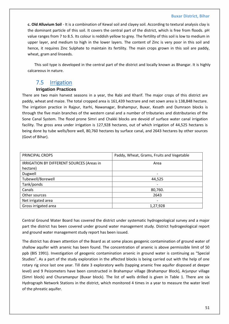
7.5 Irrigation Irrigation Practices
There are two main harvest seasons in a year, the Rabi and Kharif. The major crops of this district are
paddy, wheat and maize. The total cropped area is 161,439 hectrare and net sown area is 138,848 hectare.
The irrigation practice in Rajpur, Itarhi, Nawanagar, Brahampur, Buxar, Kesath and Dumraon blocks is
through the five main branches of the western canal and a number of tributaries and distributaries of the
Sone Canal System. The flood prone Simri and Chakki blocks are devoid of surface water canal irrigation
facility. The gross area under irrigation is 127,928 hectares, out of which irrigation of 44,525 hectares is
being done by tube wells/bore well, 80,760 hectares by surface canal, and 2643 hectares by other sources
(Govt of Bihar).
PRINCIPAL CROPS Paddy, Wheat, Grams, Fruits and Vegetable
IRRIGATION BY DIFFERENT SOURCES (Areas in hectare)
Area
Dugwell -
Tubewell/Borewell 44,525
Tank/ponds -
Canals 80,760.
Other sources 2643
Net irrigated area -
Gross irrigated area 1,27,928
Central Ground Water Board has covered the district under systematic hydrogeological survey and a major
part the district has been covered under ground water management study. District hydrogeological report
and ground water management study report has been issued.
The district has drawn attention of the Board as at some places geogenic contamination of ground water of
shallow aquifer with arsenic has been found. The concentration of arsenic is above permissible limit of 50
ppb (BIS 1991). Investigation of geogenic contamination arsenic in ground water is continuing as “Special
Studies”. As a part of the study exploration in the affected blocks is being carried out with the help of one
rotary rig since last one year. Till date 3 exploratory wells (tapping arsenic free aquifer disposed at deeper
level) and 9 Peizometers have been constructed in Brahampur village (Brahampur Block), Arjunpur village
(Simri block) and Churamanpur (Buxar block). The list of wells drilled is given in Table 1. There are six
Hydrograph Network Stations in the district, which monitored 4 times in a year to measure the water level
of the phreatic aquifer.
Buxar District, Bihar
52
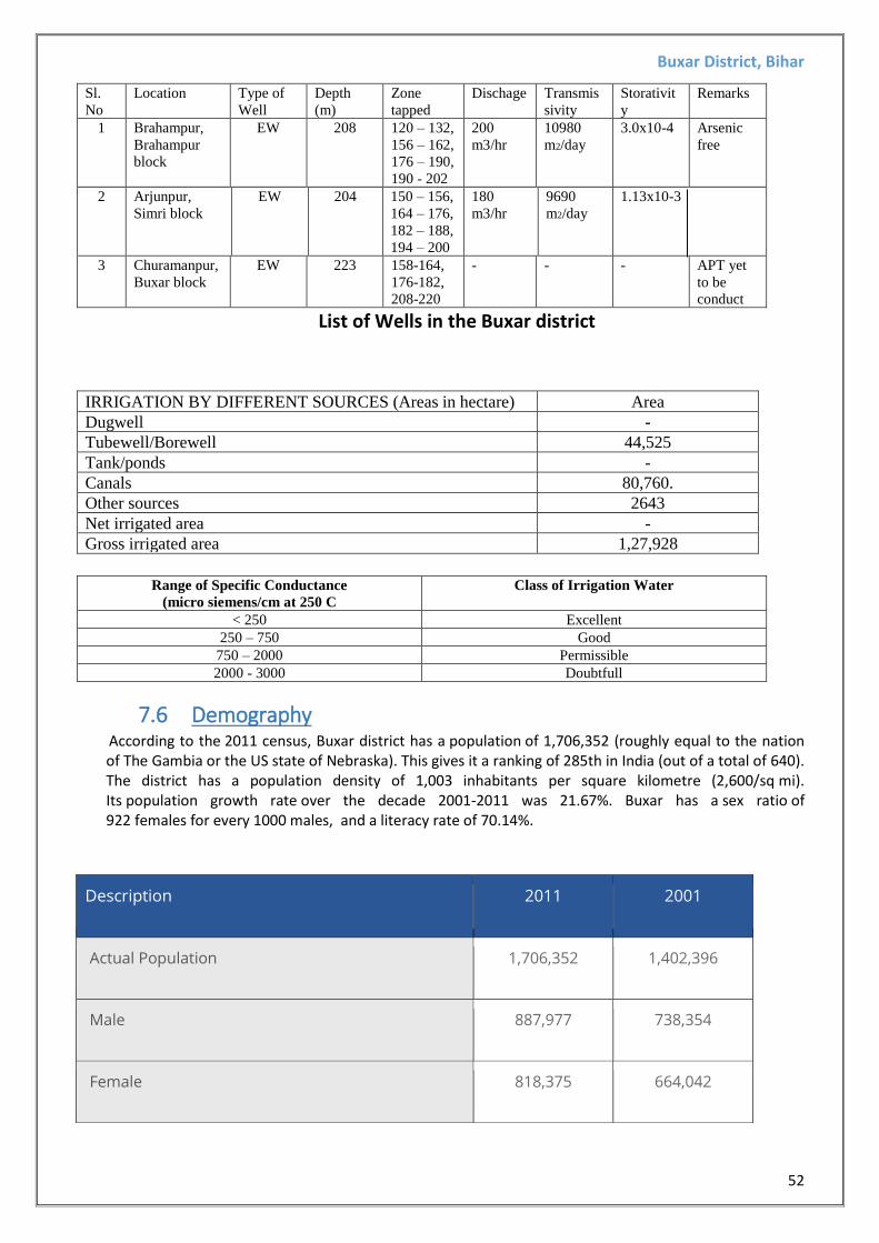
Sl.
No
Location Type of
Well
Depth
(m)
Zone
tapped
Dischage Transmis
sivity
Storativit
y
Remarks
1 Brahampur,
Brahampur
block
EW 208 120 – 132,
156 – 162,
176 – 190,
190 - 202
200
m3/hr
10980
m2/day
3.0x10⁻⁴ Arsenic
free
2 Arjunpur,
Simri block
EW 204 150 – 156,
164 – 176,
182 – 188,
194 – 200
180
m3/hr
9690
m2/day
1.13x10⁻³
3 Churamanpur,
Buxar block
EW 223 158-164,
176-182,
208-220
- - - APT yet
to be
conduct
List of Wells in the Buxar district
IRRIGATION BY DIFFERENT SOURCES (Areas in hectare) Area
Dugwell -
Tubewell/Borewell 44,525
Tank/ponds -
Canals 80,760.
Other sources 2643
Net irrigated area -
Gross irrigated area 1,27,928
Range of Specific Conductance
(micro siemens/cm at 250 C
Class of Irrigation Water
< 250 Excellent
250 – 750 Good
750 – 2000 Permissible
2000 - 3000 Doubtfull
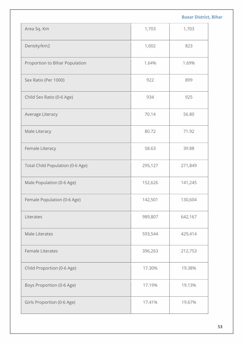
7.6 Demography According to the 2011 census, Buxar district has a population of 1,706,352 (roughly equal to the nation
of The Gambia or the US state of Nebraska). This gives it a ranking of 285th in India (out of a total of 640). The district has a population density of 1,003 inhabitants per square kilometre (2,600/sq mi). Its population growth rate over the decade 2001-2011 was 21.67%. Buxar has a sex ratio of 922 females for every 1000 males, and a literacy rate of 70.14%.
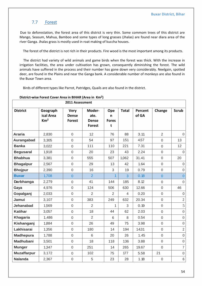
Due to deforestation, the forest area of this district is very thin. Some commom trees of this district are Mango, Seasum, Mahua, Bamboo and some types of long grasses (Jhalas) are found near diara area of the river Ganga. Jhalas grass is mostly used in roat making of kuccha houses.
The forest of the district is not rich in their products. Fire wood is the most important among its products.
The district had variety of wild animals and game birds when the forest was thick. With the increase in irrigation facilities, the area under cultivation has grown, consequently diminishing the forest. The wild animals have suffered in the process and their number has gone down very considerably. Neelgain, spotted deer, are found in the Plains and near the Ganga bank. A considerable number of monkeys are also found in the Buxar Town area.
Birds of different types like Parrot, Patridges, Quails are also found in the district.
District-wise Forest Cover Area in BIHAR (Area in Km2) 2011 Assessment
District Geograph ical Area Km2
Very Dense Forest
Moder-ate.
Dense Forest
Open
Forest
Total Percent of GA
Change Scrub
Araria 2,830 0 12 76 88 3.11 2 0
Aurangabad 3,305 0 54 97 151 4.57 0 13
Banka 3,022 0 111 110 221 7.31 0 12
Begusaral 1,918 0 20 23 43 2.24 0 0
Bhabhua 3,381 0 555 507 1,062 31.41 0 20
Bhagalpur 2,567 0 29 13 42 1.64 0 0
Bhojpur 2,390 0 16 3 19 0.79 0 0
Buxar 1,708 0 2 1 3 0.18 0 0
Darbhanga 2,279 0 41 144 185 8.12 0 0
Gaya 4,976 0 124 506 630 12.66 0 46
Gopalganj 2,033 0 2 2 4 0.20 0 0
Jamui 3,107 0 383 249 632 20.34 0 2
Jehanabad 1,569 0 2 1 3 0.19 0 5
Katihar 3,057 0 18 44 62 2.03 0 0
Khagaria 1,486 0 2 6 8 0.54 0 0
Kishanganj 1,884 0 26 49 75 3.98 0 0
Lakhisarai 1,356 0 180 14 194 14.31 0 2
Madhepura 1,788 0 6 20 26 1.45 0 0
Madhubani 3,501 0 18 118 136 3.88 0 0
Munger 1,347 0 251 14 265 19.67 0 7
Muzaffarpur 3,172 0 102 75 177 5.58 21 0
Nalanda 2,367 0 5 23 28 1.18 0 6
Buxar District, Bihar
55
Nawada 2,494 0 187 323 510 20.45 0 10
Pashchimi Champ1uan
5,228 231 524 166 921 17.62 8 0
(Source: India state of forest report 2011-Bihar)
Flora of the area:-
Due to deforestation, the forest area of this district is very thin. Some commom trees of this district are Mango, Seasum, Mahua, Bamboo and some types of long grasses (Jhalas) are found near diara area of the river Ganga. Jhalas grass is mostly used in roat making of kuccha houses.
Fauna of the area:-
The wild animals have suffered in the process and their number has gone down very considerably. Neelgain, spotted deer, are found in the Plains and near the Ganga bank. A considerable number of monkeys are also found in the Buxar Town area. Birds of different types like Parrot, Patridges, Quails are also found in the district.
7.8 Hydrogeology :- Buxar forms a part of the axial belt of the Indo-Gangetic plain and consists of Newer and Older alluvium of Quaternary age. The lithology of the region is as under.
System Series Formation Lithology
Quaternary
Recent to
Upper Pleistocene
Newer Alluvium Sand, silt and clay Coarse textured
facies,,
Upper to middle
pleistocene
Older Alluvium
Unconformity-
Clay, with Kankar, fine medium coarse
grained sand. Coarse textured facies.
Pre Cambrian Vindhyan formations
Buxar District, Bihar
56
Buxar District, Bihar
57
Buxar District, Bihar
58
Pre-monsoon (May 2011) water level map of Buxar district
Post-monsoon (November 2011) water level map of Buxar district
Buxar District, Bihar
59
8. Land Utilization Pattern of the District
Agriculture is the main occupation of the people of the district and also the main source of livelihood of the people. Rainfall still controls the agricultural economy of Buxar district. Conditions have, however, improved to some extent to meet the situation caused by the failure of monsoon. Rice, Wheat, Grams and pulses are grown here. In this district both the irrigated and un-irrigated areas excepting the hills and forests are being exploited for cultivation. Horticulture is also spreading. Rice, wheat, barely, grams and pulses are the main crops o the district. The winter rice forms the greater part of this crop. Gram is by far the most important among the pulses grown in the district. The other pulses grown are arhar, khesari and masur. The important among the crops of the district other than rice and wheat are oil seed and sugar cane. The straw is used as fodder and for roofing the house.
As per Village Directory data of 2011-Census, landuse pattern figures are as follows:-
Total Forest
Area(inHectares) Total Irrigated
Lan Area (in
Hectares)
Total Unirrigated
Land Area (in
Hecta
Culturable
Waste Land
Area (in
Hectares)
Barren Un-
cultivable
Land Area (in
Hectares)
Area under
Non-
Agricultur al
Uses (in
Hectares
62.5 113747 19995.9 234.6 318.6 20874.3
Buxar District, Bihar
60
9. Physiography of The District
Buxar district is a part of the southern Ganga Plain. Physiography of the district is a alluvial plain having gentle slope towards north. The plain land is marked by presence of several minor depressions. The elevation of the land surface in the district varies between 55 m amsl and 85 m amsl. Broadly the district can be divided into two micro physiographic units: -
1. The low-lying northern plain - extends from the Ganga. The river Ganga has built a long natural levee along its course. Every year this unit gets fresh deposit of silt. As a result of siltation the region is rich in fertile soil. The low-lying areas are important for the cultivation of wheat, Maize and gram. The entire geographical area of Simri and Chakki blocks and a part of Buxar and Brahampur blocks fall under this category.
2. The flat region of the south – It extends southwards of the railway line, which passes through the district in east-west direction. This geomorphic unit is densely populated, covered by network of canal of Sone Canal System. Its western limit follows the course of river Ganga followed by Karmnasa. This unit covers major part of the district occupying entire geographica area of Chausa, Rajpur, Kesath, Nawanagar, Itarhi, Dumraon blocks and parts of Buxar & Barhampur blocks. The unit is considered to be suitable for wheat and paddy cultivation.
Buxar District, Bihar
61
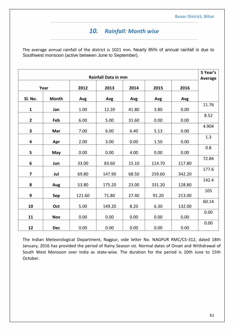
10. Rainfall: Month wise
The average annual rainfall of the district is 1021 mm. Nearly 85% of annual rainfall is due to
Southwest monsoon (active between June to September).
Rainfall Data in mm 5 Year’s Average
Year 2012 2013 2014 2015 2016
Sl. No. Month Avg Avg Avg Avg Avg
1 Jan 1.00 12.20 41.80 3.80 0.00 11.76
2 Feb 6.00 5.00 31.60 0.00 0.00 8.52
3 Mar 7.00 6.00 6.40 5.13 0.00 4.904
4 Apr 2.00 3.00 0.00 1.50 0.00 1.3
5 May 0.00 0.00 4.00 0.00 0.00 0.8
6 Jun 33.00 83.60 15.10 114.70 117.80 72.84
7 Jul 69.80 147.90 68.50 259.60 342.20 177.6
8 Aug 53.80 175.20 23.00 331.20 128.80 142.4
9 Sep 121.60 71.80 27.40 91.20 213.00 105
10 Oct 5.00 149.20 8.20 6.30 132.00 60.14
11 Nov 0.00 0.00 0.00 0.00 0.00 0.00
12 Dec 0.00 0.00 0.00 0.00 0.00 0.00
The Indian Meteorological Department, Nagpur, vide letter No. NAGPUR RMC/CS-312, dated 18th
January, 2016 has provided the period of Rainy Season viz. Normal dates of Onset and Withdrawal of
South West Monsoon over India as state-wise. The duration for the period is 10th June to 15th
October.
Buxar District, Bihar
62
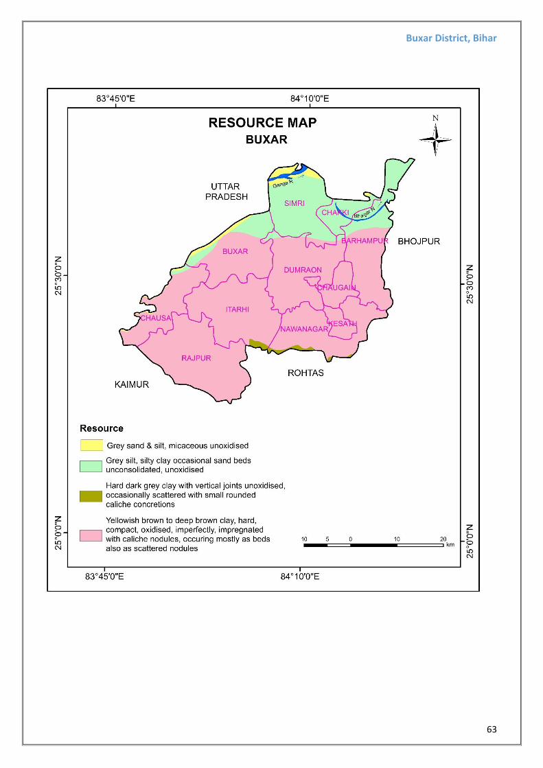
11. GEOLOGY AND THE MINERAL WEALTH OF THE AREA
Geologically the area forms a part of the SON_GANGA inter flue belt in Buxar district, lying in the
south of the river Ganga. The SON_GANGA inter flue belt in turn constitutes a part of INDO-
GANGETIC PLAIN of Bihar. The sediment contribution in this belt is from both the southern
peninsular and northern extra-peninsular high. The Ganga river system has brought sediments from
extra-peninsular mountainous areas. Where as the Son, Kao, Karamnasa and Phalgu etc flowing
through the regions of Vindhyans and Chhotanagpur gneissic terrain brought sediment materials
from peninsular high and build a vast gently undulating alluvial tract to the south of the river
Ganga. The sediments are mainly consolidated to semi-consolidated Sand, Silt and Clay of different
colors in various proportion.
The Litho- stratigraphic super-position of the area may be described as follows:-
Holocene Diara formation/ Surface,
Fatwa formation/ Surface,
Meso to new Nawada formation..
Pleistocene
Nawada formation comprises light yellow to light brown occasionally reddish brown, sticky, hard
compact and mature soil, containing Calcareous and fenugenious Concretion. The composition
varies from silty- clay to sand. The Fatwa formation comprises grey to dark grey silty clayey
sediments. The alluvial fill deposits of this formations are comparatively less compact and less
oxidized with alternate sequence of sand and silk showing primary sedimentary structures. The
Diara formation comprises white to grayish white, dominantly loose to partly semi-consolidated,
micaceous, silty sand to extremely fine grained clayey sediments. The lithology exhibits a wide
range of sedimentary structure indicating fluctuating hydrodynamic condition. Fatwa formation
provides materials for making bricks of buildings.
Buxar District, Bihar
63
Buxar District, Bihar
64
Buxar District, Bihar
65
12. ADDITIONAL INFORMATION
12.1 Drainage system with description of main rivers
Drainage system with description of main river
Sl.no Name of the River
Cross Section area of catchment (square km) (Cosidering 500 m Both Side from bank of the
river)
District of Buxar area in (square km)
% Area Drained in the District
1 Ganga 126 1,624 7.76
12.2 Salient features of Important Rivers and Streams
Salient Features of Important River and Streams
S.no Name of the River
Stream Total Length in the
District (in km) place of Origin Altitude at Origin
1 Ganga 41.52 Kanda 3655 12.3 Mineral Potential and Annual Deposition
Name of the River
Portion of the River
Strem Recommended for Mineral
Concession ( in km )
Length of are
recommended for mineral
concession (in km)
Length of are
recommended for mineral
concession (in
meter)
Average width of
are recommended for mineral
concesion (in
meters)
Depth in meter (as
per statue)
Volume recommended for mineral
concesion (in square
meters)
Area recommended for mineral
concesion (in cum)
Mineable Mineral
Potential (in metric tonne)60% of tatal mineral
potential
Ganga 27 2.6 2600 506 0.5 1315600 657800 745945.2
Current Mineral Potential (2018 pre monsoon period)
Name of the River Boulder (MT) Bajari (MT) Total resuorcess in mt
recommended for minral consesion
Total Mineable Mineral Potential
at 60% (MT)
Ganga Nil Nil 1243242 745945.2
Average annual deposition observed (2018 post monsoon period)
Ganga Nil Nil 1243242 745945.2
Buxar District, Bihar
66
13. DISASTER RISK MANAGEMENT
The Basis
The fundamentals of existence lie in the struggle one has fought, the instruments one has used and the lessons one has learnt to survive. In this respect, Bihar‘s struggle for existence is far more grim than most of the states. It has undergone mitosis for as many as four times and has suffered through disasters of the worst kind many a time.
The Vision :
Right from the days following the battle of Buxar in 1764 after which Bihar was passed on to
East India Company as a part of the Bengal Presidency, to 1912 when Bihar and Orissa were
separated as one State, to 1936 when both Bihar and Orissa were made independent States,
to 1956 when some key areas of Bihar was included in West Bengal, to 2000 when Bihar was
divided to form the state of Jharkhand, the State has went on losing its natural resource base
and got pushed to confine within an area prone to all sort of hazard: earthquake, flood,
cyclonic storm/Gale /Hail Storm, drought, fire, extreme cold and heat waves etc.
For such a state of hazards which Bihar is, the VISION of Disaster Management is :
“To attain a position where people are ready to help themselves, local bodies to
extend mutual help, the administration to organize public help and the government
to facilitate the helping of helpers.”
The Objectives:
In order to achieve the Mission, the objectives of the plan have been set as :
i. Treating community as the primary stakeholder and first respondent in the Disaster Management Plan, focusing on disaster risk reduction, prevention, mitigation and preparedness measures.
ii. Emphasizing preparedness at the community level and readiness at the local bodies level
iii. Facilitating the role play by the administration and government departments and other stakeholders through institutional mechanism.
iv. Creation of specialized institutions to make disaster management an inclusive exercise and to wed it to development initiatives.
v. To create a dependable early warning system to warn the people and activate other stakeholders.
vi. Ensuring quick response and providing relief with care and attention to those belonging to the marginalized section.
vii. To undertake rehabilitation with "Build Back Better" motif.
Buxar District, Bihar
67
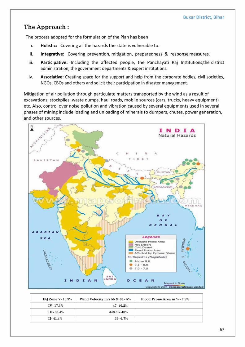
The Approach :
The process adopted for the formulation of the Plan has been
i. Holistic: Covering all the hazards the state is vulnerable to.
ii. Integrative: Covering prevention, mitigation, preparedness & response measures.
iii. Participative: Including the affected people, the Panchayati Raj Institutions,the district administration, the government departments & expert institutions.
iv. Associative: Creating space for the support and help from the corporate bodies, civil societies, NGOs, CBOs and others and solicit their participation in disaster management.
Mitigation of air pollution through particulate matters transported by the wind as a result of excavations, stockpiles, waste dumps, haul roads, mobile sources (cars, trucks, heavy equipment) etc. Also, control over noise pollution and vibration caused by several equipments used in several phases of mining include loading and unloading of minerals to dumpers, chutes, power generation, and other sources.
EQ Zone V- 10.9%
Wind Velocity m/s 55 & 50 - 5%
Flood Prone Area in % - 7.9%
IV- 17.3% 47- 40.2%
III- 30.4% 44&39- 48%
II- 41.4% 33- 6.7%
Buxar District, Bihar
68
FLOOD PRONE AREA IN BIHAR:
Source: Developed on Inputs from DMD, GoB
2. Flood— Most Vulnerable : East Champaran, Sheohar, Sitamarhi, Katihar,
Madhubani, Vaishali, Muzaffarpur, Darbhanga,
Samastipur, Madhepra, Supaul, Saharsa,
Khagaria, Begusarai, Bhagalpur.
Vulnerable : West Champaran, Gopalganj, Siwan, Saran,