Granite (Building Stone) Quarry owned by Mubasheer. V. K at Pulikkal Village, Kondotty Taluk & Malappuram District, Kerala. PRE-FEASIBILTY REPORT 1.0 INTRODUCTION OF THE MINING ACTIVITY Mubasheer. V. K for Mubasheer Quarry is proposing an existing (Building Stone) Quarry with Permit at Survey No. 180/3-2 of Pulikkal Village, Kondotty Taluk, Malappuram District, Kerala for an area of 0.4951 hectares. The proposed quarry area is hillock. In most parts of the quarry permit area, the rocks are exposed and also the granite (building stone) exposures are present / bordering to the permit boundary proving the occurrence of the granite (building stone). The proposed quarry area is located at pulikkal, 12 km from Ramanattukara and 28 km from Malappuram. The highest elevation of the permit area is 130m MSL and lowest is 70m MSL . As the proposed area is hillock, the drainage of the permit area is towards north east direction. No habitants are located in the permit area. The geological resources of granite (building stone) in mining permit area are estimated to be 3,35,930MT. The Blocked Reserves and Mineable Reserve of granite( building stone) in mining permit area are estimated to be 1,90,610MT and 1,45,320MT respectively. In the first five years of plan period, total 1,45,000 Tons of granite (building stone) shall be quarried/mined. The balance mineral reserves and part of blocked resources shall be quarried after modifying the bench design in next five year period. Kerala experiences rainfall on duration of 3 to 4 months in a year and the quarry operations will be affected because of the rainy days. The anticipated life of the quarry is 5 years expected.
Transcript
Granite (Building Stone) Quarry owned by Mubasheer. V. K at PulikkalVillage, Kondotty Taluk & Malappuram District, Kerala.
PRE-FEASIBILTY REPORT
1.0 INTRODUCTION OF THE MINING ACTIVITY
Mubasheer. V. K for Mubasheer Quarry is proposing an existing (Building
Stone) Quarry with Permit at Survey No. 180/3-2 of Pulikkal Village,
Kondotty Taluk, Malappuram District, Kerala for an area of 0.4951
hectares. The proposed quarry area is hillock. In most parts of the quarry
permit area, the rocks are exposed and also the granite (building stone)
exposures are present / bordering to the permit boundary proving the
occurrence of the granite (building stone).
The proposed quarry area is located at pulikkal, 12 km from
Ramanattukara and 28 km from Malappuram. The highest elevation of the
permit area is 130m MSL and lowest is 70m MSL . As the proposed area is
hillock, the drainage of the permit area is towards north east direction. No
habitants are located in the permit area.
The geological resources of granite (building stone) in mining
permit area are estimated to be 3,35,930MT. The Blocked Reserves and
Mineable Reserve of granite( building stone) in mining permit area are
estimated to be 1,90,610MT and 1,45,320MT respectively. In the first five
years of plan period, total 1,45,000Tons of granite (building stone) shall
be quarried/mined. The balance mineral reserves and part of blocked
resources shall be quarried after modifying the bench design in next five
year period.
Kerala experiences rainfall on duration of 3 to 4 months in a year
and the quarry operations will be affected because of the rainy days. The
anticipated life of the quarry is 5 years expected.
Granite (Building Stone) Quarry owned by Mubasheer. V. K at PulikkalVillage, Kondotty Taluk & Malappuram District, Kerala.
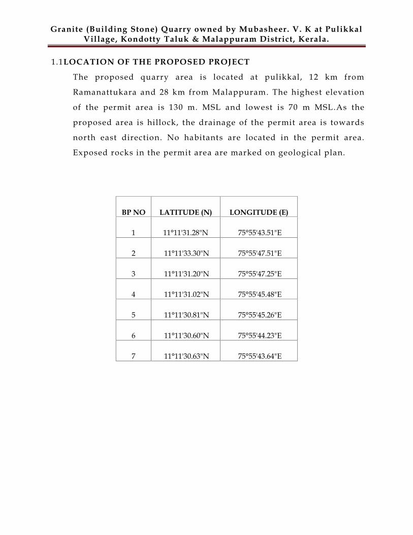
1.1LOCATION OF THE PROPOSED PROJECT
The proposed quarry area is located at pulikkal, 12 km from
Ramanattukara and 28 km from Malappuram. The highest elevation
of the permit area is 130 m. MSL and lowest is 70 m MSL.As the
proposed area is hillock, the drainage of the permit area is towards
north east direction. No habitants are located in the permit area.
Exposed rocks in the permit area are marked on geological plan.
BP NO LATITUDE (N) LONGITUDE (E)
1 11°11'31.28"N 75°55'43.51"E
2 11°11'33.30"N 75°55'47.51"E
3 11°11'31.20"N 75°55'47.25"E
4 11°11'31.02"N 75°55'45.48"E
5 11°11'30.81"N 75°55'45.26"E
6 11°11'30.60"N 75°55'44.23"E
7 11°11'30.63"N 75°55'43.64"E
Granite (Building Stone) Quarry owned by Mubasheer. V. K at PulikkalVillage, Kondotty Taluk & Malappuram District, Kerala.
Figure 1.0 Key Plan
Granite (Building Stone) Quarry owned by Mubasheer. V. K at PulikkalVillage, Kondotty Taluk & Malappuram District, Kerala.
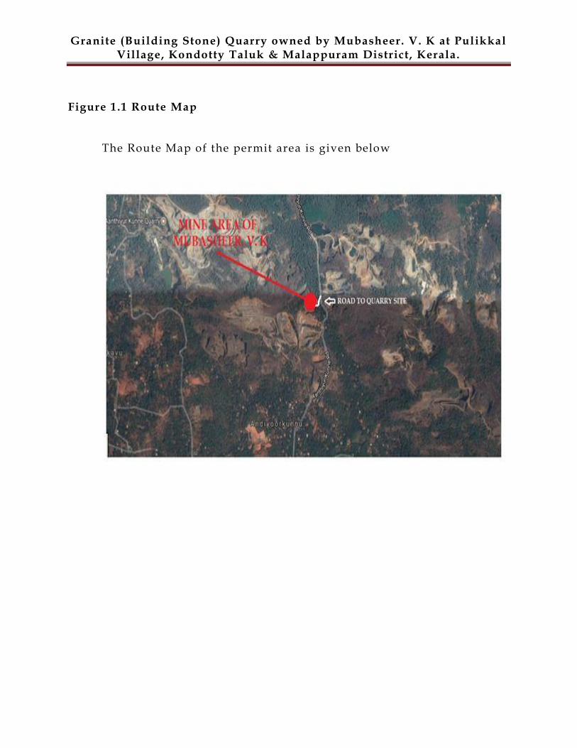
Figure 1.1 Route Map
The Route Map of the permit area is given below
Granite (Building Stone) Quarry owned by Mubasheer. V. K at PulikkalVillage, Kondotty Taluk & Malappuram District, Kerala.
Figure 1.2 Google Map with site superimposing
The Google Map with site superimposing of the permit area is given
below
Granite (Building Stone) Quarry owned by Mubasheer. V. K at PulikkalVillage, Kondotty Taluk & Malappuram District, Kerala.
1.2PROJECT PROPONENT INFORMATION
Name and
address of the
Applicant
:Mubasheer. V. K
Vythalakuzhiyil House,
Cheruppa P.O,Kozhikode District, Kerala .
1.3 NEED FOR THE PROJECT AND ITS IMPORTANCE TO THE COUNTRY OR
REGION
The major essentiality of building stone is based on its extraordinary compressive
strength and durability (among the hardest, dimensional & structural stones) and it is
having high tolerance towards the vagaries of nature. In construction activities, these are
being used because of its hardness & density, durability and strength craft. The proposed
mining project will accomplish its requirement for the construction of buildings, bridges,
paving, monuments and many other exterior projects. Polished slabs and tiles are usually
used in countertops, flooring, retaining walls and landscaping around a center fountain/
pond, staircase and many other design elements (residential and commercial
applications). It is also known as the maintenance-free stone.
The employment opportunities are being created in connection with the quarrying
activities and the local people are being employed for the non -technical activities under
the direction of mining engineers and supervisors. For the quarry operations, 12 employees
are being deployed which generates ample opportunities for those peoples indirectly.
Applicant will pay royalty for the mineral produced from the mine, direct and
indirect taxes will be paid thereby contributing to the regional revenue. The public revenue
will further be put for infrastructural development and other sectors like health, education
and social welfare.
1.4 END USE (DOMESTIC/ EXPORT MARKET)
Granite (Building Stone) Quarry owned by Mubasheer. V. K at PulikkalVillage, Kondotty Taluk & Malappuram District, Kerala.
The rock produced from the quarry is transported to the Crusher unit.
The aggregate produced is sold to the contractors and to the consumers
which is finally consumed locally for road (State Highway & National
Highway) & building construction works. Fine Mater ial is also sold for the
utilization of the hollow block/ solid block manufactures.
2.0 PROJECT DESCRIPTION
2.1 SALIENT FEATURES & ENVIRONMENTAL SETTING OF THE
PROJECT
Particulars Details
Total Mine Permit area 0.4951 hectares
Total area owned by the
proponent
Private owned land by the Project Proponent
Current status of the
quarry
Existing Quarry
Local name of the project
area (Name of the hill)
Anthiyoorkunnu
Production The geological resources of granite (building
stone) in mining permit area are estimate to
3,35,930MT and production / mineable
reserves are 1,45,320MT . In the first five years
of plan period 1,45,000Tons granite (building
stone) shall be quarried/mined. The balance
mineral reserves and part of blocked
resources shall be quarried after modifying
the bench design in next five year period.
Granite (Building Stone) Quarry owned by Mubasheer. V. K at PulikkalVillage, Kondotty Taluk & Malappuram District, Kerala.
Life of Mine 5Years
Estimated project cost Rs. 10 Lakhs
Man Power 12 (on permanent / contract basis)
Highest and lowest
elevation130 MSL & 70 MSL
Land use Private own Land
Nearest habitation No houses within 100 m. radius from the
proposed quarry
Nearest town Pulikkal- 3km
Stone Crusher & M Sand Chengotu Stone Crusher unit,6km away from
the quarry
Width of access road to
the quarry site7 m, Pulikkal-Mayakkara Road
Nearest Airport Calicut International Airport,12km
Nearest Highway Malappuram – Kozhikode,4km
Nearest Railway Station Kozhikode Railway Station,25km
Details of nearby quarry
/ crusherQuarry Owned by Abdulla Koya(Beeta
Granites),(Kondotty Taluk ,Pullikal
Village)Survey No:266/2pt,Area :9.007Ha
Quarry Owned by Abbasali.K.P,(Kondotty
Taluk, Pullikal Village)Survey No:180/1-
2,320/pt,Area :80Ares
Granite (Building Stone) Quarry owned by Mubasheer. V. K at PulikkalVillage, Kondotty Taluk & Malappuram District, Kerala.
Quarry Owned by Abdul Nazar, ,(Kondotty
Taluk, Pullikal Village)Survey
No:180/1/2,29/3,4,Area :40Ares
Quarry Owned by V.P.Abdulla,Elite Granite
& Hollow Bricks(Kondotty Taluk, Pullikal
Village),Survey No:180/6,Area :1.4410Ha
Quarry Owned by K.M.Alikutty,(Kondotty
Taluk ,Pullikal Village),Survey
No:181/1,Area :40.40Ares
Quarry Owned by Moosa,(Kondotty Taluk,
Pullikal Village),
Survey No:177/6,177/7,180/1/1,
Area :1.0567Ha,9.71Ares
Quarry Owned by Kuttiyamu Haji ,(Kondotty
Taluk, Pullikal Village),Survey
No:177/8,Area :20Ares
Granite (Building Stone) Quarry owned by Mubasheer. V. K at PulikkalVillage, Kondotty Taluk & Malappuram District, Kerala.
Power supply Nil
Water and its Source The total water requirement is about 2KLD in which 0.5 KLD is for domestic uses, 1KLD for dust suppression and 0.5 KLD forplantation purposes and will be sourced fromopen well.Domestic consumption : 0.5 KLDDust suppression : 1 KLDPlantation : 0.5KLDTOTAL : 2 KLD
Nearest Govt. Hospital /
dispensaryBM Hospital, Pulikkal,4km
Education facility AMMHS, Pulikkal,4km
Fire Station Meenchandha,18Km
Ambulance Pulikkal,2.5km
Police Station Kondotty Police Station,10km
Church / temple /mosque
None within 500 m radius
Electrical installation
like transformer /HT
line or LT line
Nil
Mobile Towers None within 500 m radius
Defense installations None within 500 m radius
Archeological Features None within 500 m radius
Ecological sensitivezones
None within 500 m radius
Granite (Building Stone) Quarry owned by Mubasheer. V. K at PulikkalVillage, Kondotty Taluk & Malappuram District, Kerala.
Nearest Forests Nil
Nearest streams/ rivers/
water bodies (from mine
boundary)
Nil
Seismic zone Zone-III , Moderate damage risk zone as par
BMTPC, Vulnerability atlas Seismic zone of
India IS: 1893-2002.
Categorization as per
WGEEP ReportAs per WGEEP classification, the project site
is located not in the vicinity of protected area
PHYSIOGRAPHY / TOPOGRAPHY / DRAINAGE PATTERN
The physiography of the quarry area is a part of elevated terrain.
The topography of the permit area is hilly terrain with granite (building
stone) deposit . . The highest elevation of the permit area is 130 m. MSL
and lowest is 70m MSL. The topographic / surface plan on 1:1000 scale
which incorporates all the existing details like topography, surface
exposures, structures etc. and enclosed in the Mining plan.
2.3 PERMITHOLD AREA
The quarry site covers the mining area of 0.4951 Ha is a Private own land and in
most part of the quarry permit area, rocks are exposed and remaining
part with very small amount of top soil and local vegetation .
The permit area does not comprise of any protected or reserved forest lands. Ecologically
sensitive features like national parks, biospheres, sanctuaries, elephant corridors, Tiger
reserves, flight paths of migrating fauna, etc., are also not visible in this vicinity of core zone.
1.4 GEOLOGY
Granite (Building Stone) Quarry owned by Mubasheer. V. K at PulikkalVillage, Kondotty Taluk & Malappuram District, Kerala.
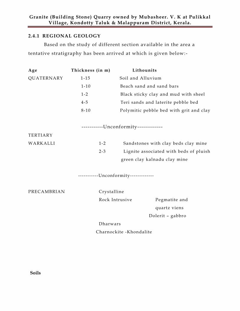
2.4.1 REGIONAL GEOLOGY
Based on the study of different section available in the area a
tentative stratigraphy has been arrived at which is given below: -
Age Thickness (in m) Lithounits
QUATERNARY 1-15 Soil and Alluvium
1-10 Beach sand and sand bars
1-2 Black sticky clay and mud with sheel
4-5 Teri sands and laterite pebble bed
8-10 Polymitic pebble bed with grit and clay
-----------Unconformity-------------
TERTIARY
WARKALLI 1-2 Sandstones with clay beds clay mine
2-3 Lignite associated with beds of pluish
green clay kalnadu clay mine
-----------Unconformity-------------
PRECAMBRIAN Crystalline
Rock Intrusive Pegmatite and
quartz viens
Dolerit – gabbro
Dharwars
Charnockite -Khondalite
Soils
Granite (Building Stone) Quarry owned by Mubasheer. V. K at PulikkalVillage, Kondotty Taluk & Malappuram District, Kerala.
The soil types occurring in Malappuram district can be broadly grouped into four
types on the basis of their physio-chemical properties and morphological features.
They are (a) Lateritic soil. (b) Riverine lluvium, (c) Brown hydromorphic, and (d)
Forest loams.
2.4.2 LOCAL GEOLOGY
The local geology belongs to the regional geology. Main rock type in the
study area is charnockite. At places where they are exposed, the
charnockite is medium to coarse grained with dark grey quartz. The top
soil & over burden thickness varies from avg 1 m. to 0.8 m.
topographically, the area is undulating.
A geological plan showing the granites and soil cover and the geological
sections showing subsurface geology is prepared on 1:1000 scale.
Local Geology
Top soil (thickness in m.) 1
Over Burden (thickness in m.) 0.8
The local geology belongs to the regional geology and topographically the
area is hilly. In the permit area, the granite occurs as massive
consolidated formation. The geological plan of the area is prepared and
attached. Geological cross sections have been drawn at fixed intervals
across the permit area in Plate No. 3. The section line along which the
geological sections have been prepared has been shown in Plate No. 3.
The Sections has been drawn across the strike of the host rock.
The soil thickness varies from avg. 1 m to 0.8m whereas granite (
building stone) are very well exposed in most part of the si te and the
evidence of the granite( building stone) is seen in the old worked pits in
Granite (Building Stone) Quarry owned by Mubasheer. V. K at PulikkalVillage, Kondotty Taluk & Malappuram District, Kerala.
the nearby areas.
A geological plan showing the granites and soil cover and the geological
sections showing subsurface geology are prepared on 1:1000 scale.
2.5 MINEABLE RESERVES
In this area, the (building stone) exposures are bordering to the permit
boundary. The mineable reserves are arrived after deducting the reserves
locked in mines safety slope along with boundary in compliance with
mineral concession rules. The quantity of such kind of reserves is arrived as
following:
SECTION BLOCKEDRESERVE (MT)
MINEABLERESERVE (MT)
GEOLOGICALRESERVE (MT)
A-A1 190610 145320 335930
TOTAL 190610 145320 335930
2.6 DETAILS OF MINING
In this area the (building stone) is exposed to surface completely and it
is having good market demand, therefore the applicant have proposed to
produce building stone from this area. It is also proposed to undertake semi -
mechanized opencast mining method by forming suitable benches.
2.6.1 YEAR WISE PRODUCTION DETAILS
The proposed method of mining will be Semi mechanized open
cast mining. The basic mining techniques adopted will be uses of machines. For the
systematic working of open cast mines, the main development work will be the forming
of systematic benching. The height of bench will not be kept more than 5.0m at a
Granite (Building Stone) Quarry owned by Mubasheer. V. K at PulikkalVillage, Kondotty Taluk & Malappuram District, Kerala.
time and the width of the benches will be always kept safe according to
provisions. The mining will be done with the help of tools such as
drills, jack-hammer, compressors, excavators, rock breaker etc. The
targeted annual production of Granite (Building Stone) is about 29,000 MT.
Table: Year wise production of Granite (Building Stone) for 5 years of
mine is given as:-
Year Benches Minerals (MT)
I 105-110,110-115,115-
120,120-125,125-130
29,000
II 85-90,90-95,95-100,100-
105
29,000
III 70-75,75-80,80-85 29,000
IV 65-70,70-75 29,000
V 55-60,60-65,65-70 29,000
TOTAL 1,45,000
2.6.2 PROPOSED METHOD OF MINING
It is proposed to undertake Open Cast Semi-Mechanized Mining
Method.
2.6.2.1 Open Cast mining
The mining will be done by open cast semi-mechanized method of mining.
The working will be done by forming benches of 5.0m (Average) height.
The Granite (Building Stone) production will be started from the first
year. The systematic working of open cast mines, the main development
Granite (Building Stone) Quarry owned by Mubasheer. V. K at PulikkalVillage, Kondotty Taluk & Malappuram District, Kerala.
work will be the forming of systematic benching. The height of bench will not
be kept more than 5.0m at a time and the width of the benches will be always
kept safe according to provisions. The Mining will be done with the help
of tools such as drills, jack-hammer, compressors, hand shovel, picks,
excavators etc. Loading of material will be done with the help of shove l
and excavators at face and at stock yard. The truck / tipper will be used
for transportation of material from mine to the destination. The cost of
the material is directly dependent on the size of the material mined. First ,
Rock bench will be opened by removal of Soil / Over Burden and then
Stone will be mined out either by labor or with the help of
Excavators/Rock Breaker.
2.6.2.2 Salient features of mining method
The mining will be done by open cast semi-mechanized method of mining.
The working will be done by forming benches of 5.0m (Average) height. The
Granite (Building Stone) production will be started from the first year. The
systematic working of open cast mines, the main development work will be the
forming of systematic benching. The height of bench will not be kept more than
5.0m at a time and the width of the benches will be always kept safe according to
provisions. The Mining will be done with the help of tools such as drills, jack-
hammer, compressors, hand shovel, picks, excavators etc. Loading of material
will be done with the help of shovel and excavators at face and at stock yard. The
truck / tipper will be used for transportation of material from mine to the
destination. The cost of the material is directly dependent on the size of the
material mined. First ,Rock bench will be opened by removal of Soil / Over
Burden and then Stone will be mined out either by labor or with the help of
Excavators/Rock Breaker.
Granite (Building Stone) Quarry owned by Mubasheer. V. K at PulikkalVillage, Kondotty Taluk & Malappuram District, Kerala.
The cost of the Stone is directly dependent on the size of the material
mined. First Stone bench will be opened by removal of Soil / OB then
Stone will be mined out either by labor or with the help of JCB /
Hitachi.
130m to 70m MSL in conceptual phase.
Considering the stability of rocks the final slope or say ultimate pit
slope is proposed 45° from vertical.
Haul road will be developed up to point of loading.
Transportation of the mineral from pit -mouth to destination will be
by tippers/trucks (10T capacity).
2.6.3 EXTENT OF MECHANIZATION
The details of equipments proposed to be used in mining operation
are listed below:-
Sr.
No.
Machine Type Required No. of
M/c
Size/Capacity
1. Excavator 1 0.9 m3
2. Rock Breaker 1 --
3. Compressor 1 CFM/100
4. Tippers/Trucks 4 10T
5. Jack hammer 1 32 mm
6. DG set Nil --`
2.6.4 CONCEPTUAL MINING PLAN
Granite (Building Stone) Quarry owned by Mubasheer. V. K at PulikkalVillage, Kondotty Taluk & Malappuram District, Kerala.
The highest elevation of the permit area is 170 m. MSL and lowest is 126
m MSL. As the proposed area is hillock, the drainage of the permit area
is towards south direction. No habitants are located in the permit area.
The geological resources of granite (building stone) in mining permit
area are estimated to be 3,35,930MT and production / mineable reserves
are 1,45,320MT. In the first years of plan period total 29,000MT granite
(building stone) shall be quarried/mined. The balance mineral reserves
and part of blocked resources shall be quarried after modifying the bench
design in next five year period.
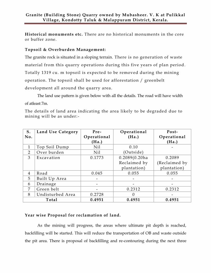
2.6.4.1 Land Use Pattern
The land use for mining and allied purposes is given below:-
S.No.
Land Use Category Pre-Operational
(Ha.)
Operational(Ha.)
Post-Operational
(Ha.)1 Top Soil Dump Nil 0.10
(Outside)-
2 Over burden Nil3 Excavation 0.1773 0.2089(0.20ha
Reclaimed byplantation)
0.2089(Reclaimed by
plantation)4 Road 0.045 0.055 0.0555 Built Up Area - - -6 Drainage - - -7 Green belt - 0.2312 0.23128 Undisturbed Area 0.2728 0 -
Total 0.4951 0.4951 0.4951
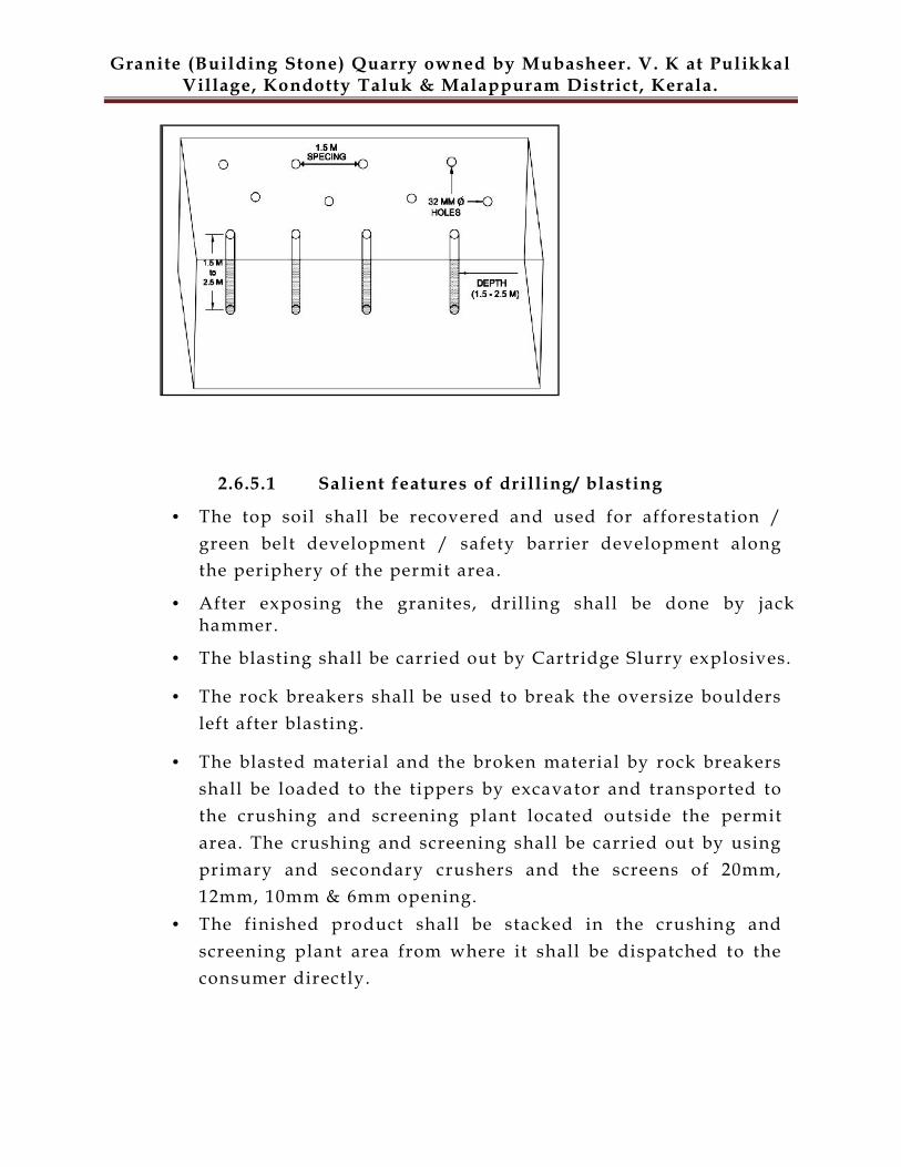
2.6.5 DRILLING
The excavation of mineral is proposed by excavators. The mineral is
fractured and easily exploitable by rock breakers and excavators. The
hard strata are proposed to excavate after drilling and blasting. The cross -
sectional view of drilling operations is shown below: -
Granite (Building Stone) Quarry owned by Mubasheer. V. K at PulikkalVillage, Kondotty Taluk & Malappuram District, Kerala.
2.6.5.1 Salient features of drilling/ blasting
The top soil shall be recovered and used for afforestation /green belt development / safety barrier development alongthe periphery of the permit area.
After exposing the granites, drilling shall be done by jackhammer.
The blasting shall be carried out by Cartridge Slurry explosives.
The rock breakers shall be used to break the oversize bouldersleft after blasting.
The blasted material and the broken material by rock breakersshall be loaded to the tippers by excavator and transported tothe crushing and screening plant located outside the permitarea. The crushing and screening shall be carried out by usingprimary and secondary crushers and the screens of 20mm,12mm, 10mm & 6mm opening.
The finished product shall be stacked in the crushing andscreening plant area from where it shall be dispatched to theconsumer directly.
Granite (Building Stone) Quarry owned by Mubasheer. V. K at PulikkalVillage, Kondotty Taluk & Malappuram District, Kerala.
2.6.6 BLASTING
The blasting design system is properly planned with ideal spacing and burden
patterns, ensuring appropriate stemming column and reduced optimized explosive
charge, so that ground vibratory effects are less, fly rocks, etc are properly regulated
and controlled. The blasting pattern depends on the strata conditions of the rocks.
Since the material in the site is Charnokite which is medium hard to full hard in nature,
it requires drilling and blasting to exploit the same. Since conventional semi
mechanized open cast method of quarrying/mining is done using drilling and
blasting, the same is adopted in this mine/quarry. The drilling and blasting
parameters are as given below.
Depth of each hole : 1.0m to 1.5 m
Diameter of the hole : 32 mm
App. Spacing between hole : 1m to 1.5m
App. Burden : 0 .6 m to 1m
Hole pattern : Multi row staggered pattern
Explosives to be used : Cartridged Slurry / electric delay detonators
2.6.6.1 Blasting Safeguard
Blasting in the open cast pit will be done only during day time atdesignated hours.
Maintaining safety distance all around the magazine as per statutory requirement Only competent blasters will be appointed to handle explosives. Proper, safe and careful handling and use of explosives by competent blastershaving Blaster's Certificate of Competency issued by DGMS
Proper security system to prevent theft/ pilferage, unauthorized entry intoMagazine area.
Granite (Building Stone) Quarry owned by Mubasheer. V. K at PulikkalVillage, Kondotty Taluk & Malappuram District, Kerala.
Controlled blasting technique will be adopted by varying burden, spacing &charge per hole depending upon the field condition.
Holes will be located beyond the weak zone after proper inspectionof the site.
No loose pieces will be kept on the bench slopes during blasting.
Stemming materials and stemming length will be chosen suitably.
Proper compaction of the stemming material will be undertaken before blasting.
Carrying out blasting during designated time only that too day time only anddisplaying a board in the mine entrance specifying the blasting time.
Posting guards at boundaries of the permit area and giving warning signal by wayof whistle or siren blowing before blasting, to prevent unauthorized entry and toprevent mishaps.
Avoiding blasting during lightening and high wind period.
The holes which have been charged with explosives will not be left unattendedtill blasting is completed
2.6.6.2 Types of Explosive Used
Only class 2 and class 6 explosive is proposed for use as given below: -
SL.NO NAME AND DESCRIPTIONCLASS &
DIVISION
SUB-
DIVISION
(IF ANY)
1 Nitrate Mixture 2,0 0
2 Safety Fuse 6,1 0
3 Electric Detonators 6,3 0
Granite (Building Stone) Quarry owned by Mubasheer. V. K at PulikkalVillage, Kondotty Taluk & Malappuram District, Kerala.
4 Ordinary Detonator 6,3 0
2.6.6.3 Storage of Explosive
The magazine will be constructing outside the mine boundary. The
controlled blasting is proposed by adopting all the safety measures as per
“MMR 1961” and with the permission of DGMS. Blasting will be performed as per
requirement on the face. The explosives are supplied by authorized dealers and the
blasting will be carried out under personal supervision of DGMS approved Blaster.
PRECAUTIONS:
a. Proper and safe storage of explosives in approved and Licensed
Magazine.
b. Proper, safe and careful handling and use of explosives by competent
Blasters having Blaster’s Certificate of Competency issued by DGMS.
c. Proper security system to prevent theft/ pilferage, unauthorized entry
into Magazine area and checking authorized persons to prevent
carrying of match box, lights, mobile phones, cigarette etc.
d. The explosives of class 2 will be used in their original cartridge packing
and such cartridge shall not be cut to remove explosive for making
cartridge of different size.
e. Detonators will be conveyed in special containers. These will not be
carried with other explosives.
f. The holes which have been charged with explosives will not be left
unattended till blasting is completed.
g. Before starting charging, clear audible warning signals by Sirens will
be given so that people nearby can take shelter.
h. Blasting operations will be carried out in day times only atdesignated hours as in this project the mining operations are proposed to becarried out in the day time only.
Granite (Building Stone) Quarry owned by Mubasheer. V. K at PulikkalVillage, Kondotty Taluk & Malappuram District, Kerala.
2.7 MINERAL TRANSPORTATION
Loading of mineral will be done by excavator and will be sent to
the crusher located outside the permit area for sizing. Trucks /
Tippers of 10T will be used for transportation of mineral from mine
site. It is expected that 10-12 trips will be required to transport on
daily basis. For this, movement of truck per hour will be 1-2 only.
Thus, the impact due to movement of trucks from the mine will be
marginal.
2.8 EMPLOYMENT POTENTIAL
An office is available in the mine area.
The total number of employees including skil led and un-skilled workers
is 12 which include workers for mine and ancillary unit . The details of the
staff and workmen employed in the mine are given below:-
TOTAL TEAM OF QUARRY OPERATIONSr.No. NAME OF THE POST NOS.