01 JULY 2019 GTI TO ACQUIRE URANIUM & VANADIUM PROPERTIES IN UTAH, USA • GTI has the exclusive right to acquire a number of highly prospective uranium and vanadium properties located in the Henry Mountains, Utah, USA. • Region has produced 92 mlbs U3O8 and 482 mlbs V2O5 at average grades of 2,400ppm and 1.25% respectively 1 from the Morrison Formation sandstones. • Properties located within trucking distance of White Mesa Mill, the only operating conventional uranium mill in the US, with ~90% licenced annual capacity still available 2 . • The Tony M mine (owned by Energy Fuels Inc, TSE:EFR) is located adjacent to the Properties and contains a remaining NI 43-101 compliant 10.9 million pound combined measured, indicated and inferred resource @ 2,183ppm U3O8 2 . • Recent XRF sampling provides evidence of potential high-grade uranium and vanadium mineralisation within Morrison Formation sandstones. • USA currently imports 98% of its annual domestic uranium demand, which poses a national security concern. • Exploration Program to commence following completion of the Acquisition. • GTI will undertake two placements and a non-renounceable rights entitlement issue to raise approximately $2m with CPS Capital Group Pty Ltd (CPS) fully underwriting the entitlement issue and acting as lead manager to the placement. GTI Resources Ltd (GTI or the Company) is pleased to advise that it has entered into a binding agreement to acquire 100% of Voyager Energy Pty Ltd (Voyager), which has the exclusive right to acquire eight highly prospective uranium/vanadium exploration projects located in the Henry Mountains mining district of south eastern Utah, USA (Agreement). The eight strategically located projects: Jake, Jeffrey, Moki, Point, Pinto, Woodruff, Rats Nest and Susannas present a portfolio of highly prospective assets containing known high-grade uranium and vanadium mineralisation (together the Properties). The property acquisition has targeted only claim areas with known historical mineralisation thus avoiding high land holding costs. 1 Geology and recognition criteria of sandstone uranium deposits of the salt wash types, Colorado Plateau Province, Union Carbine Corp, 1981, page 33 2 Annual Corporate Presentation, Energy Fuels (TSE:EFR), May 2019, page 7 Figure 1 Left: Adit located on the Jeffrey claim. Figure 2 Right: High-grade mineralised sample from adit, grab sample, pictured, assayed at ALS Global Perth 13,932ppm U3O8 2.46% V2O5 Figure 2 Figure 1 For personal use only
Transcript
01 JULY 2019 GTI TO ACQUIRE URANIUM & VANADIUM PROPERTIES IN UTAH, USA
• GTI has the exclusive right to acquire a number of highly prospective uranium and vanadium properties located in the Henry Mountains, Utah, USA.
• Region has produced 92 mlbs U3O8 and 482 mlbs V2O5 at average grades of 2,400ppm and 1.25% respectively1 from the Morrison Formation sandstones.
• Properties located within trucking distance of White Mesa Mill, the only operating conventional uranium mill in the US, with ~90% licenced annual capacity still available2.
• The Tony M mine (owned by Energy Fuels Inc, TSE:EFR) is located adjacent to the Properties and contains a remaining NI 43-101 compliant 10.9 million pound combined measured, indicated and inferred resource @ 2,183ppm U3O82.
• Recent XRF sampling provides evidence of potential high-grade uranium and vanadium mineralisation within Morrison Formation sandstones.
• USA currently imports 98% of its annual domestic uranium demand, which poses a national security concern.
• Exploration Program to commence following completion of the Acquisition. • GTI will undertake two placements and a non-renounceable rights entitlement issue to
raise approximately $2m with CPS Capital Group Pty Ltd (CPS) fully underwriting the entitlement issue and acting as lead manager to the placement.
GTI Resources Ltd (GTI or the Company) is pleased to advise that it has entered into a binding agreement to acquire 100% of Voyager Energy Pty Ltd (Voyager), which has the exclusive right to acquire eight highly prospective uranium/vanadium exploration projects located in the Henry Mountains mining district of south eastern Utah, USA (Agreement).
The eight strategically located projects: Jake, Jeffrey, Moki, Point, Pinto, Woodruff, Rats Nest and Susannas present a portfolio of highly prospective assets containing known high-grade uranium and vanadium mineralisation (together the Properties). The property acquisition has targeted only claim areas with known historical mineralisation thus avoiding high land holding costs.
1Geology and recognition criteria of sandstone uranium deposits of the salt wash types, Colorado Plateau Province, Union Carbine Corp, 1981, page 33 2 Annual Corporate Presentation, Energy Fuels (TSE:EFR), May 2019, page 7
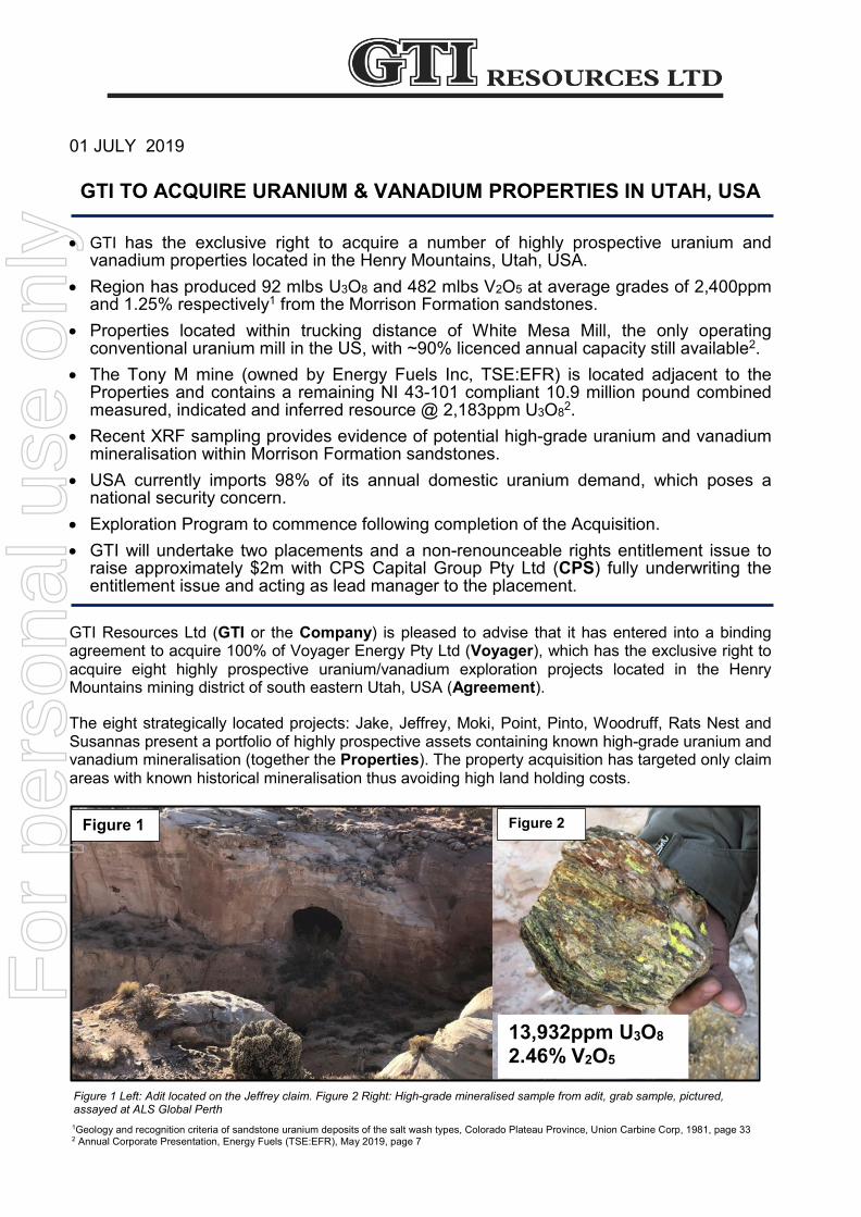
Figure 1 Left: Adit located on the Jeffrey claim. Figure 2 Right: High-grade mineralised sample from adit, grab sample, pictured, assayed at ALS Global Perth
13,932ppm U3O8 2.46% V2O5
Figure 2 Figure 1
For
per
sona
l use
onl
y
Page 2 of 15
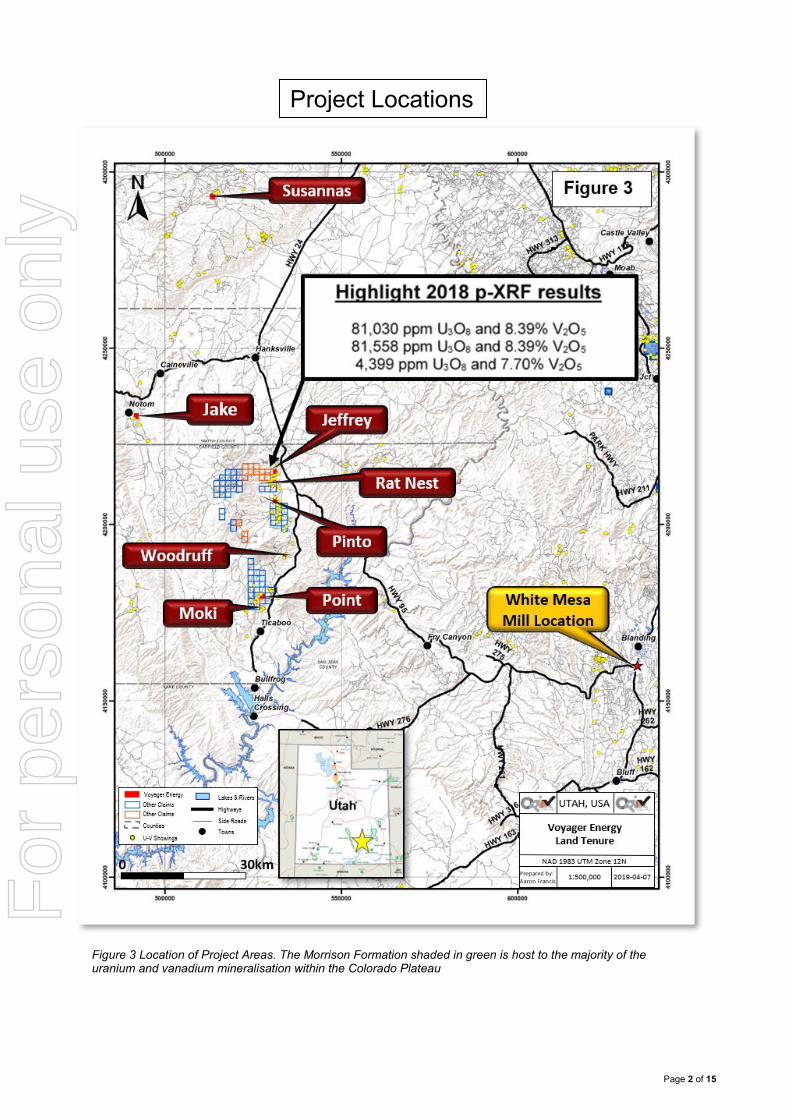
Figure 3 Location of Project Areas. The Morrison Formation shaded in green is host to the majority of the uranium and vanadium mineralisation within the Colorado Plateau
Project Locations
For
per
sona
l use
onl
y
Page 3 of 15
The Properties cover 179 claims (~3,700 acres) of the Henry Mountains region. The adjacent mining region has historically produced in excess of 17.5Mt @ 2,400ppm U3O8 (92 mlbs U3O8) and 12,500 ppm V2O5 (482 mlbs V2O5)1. Mineralisation in the region is contained to the Upper Jurassic Morrison (JM) Formation sandstones and is mainly constrained to the 10-20m thick Salt Wash Member of the JM.
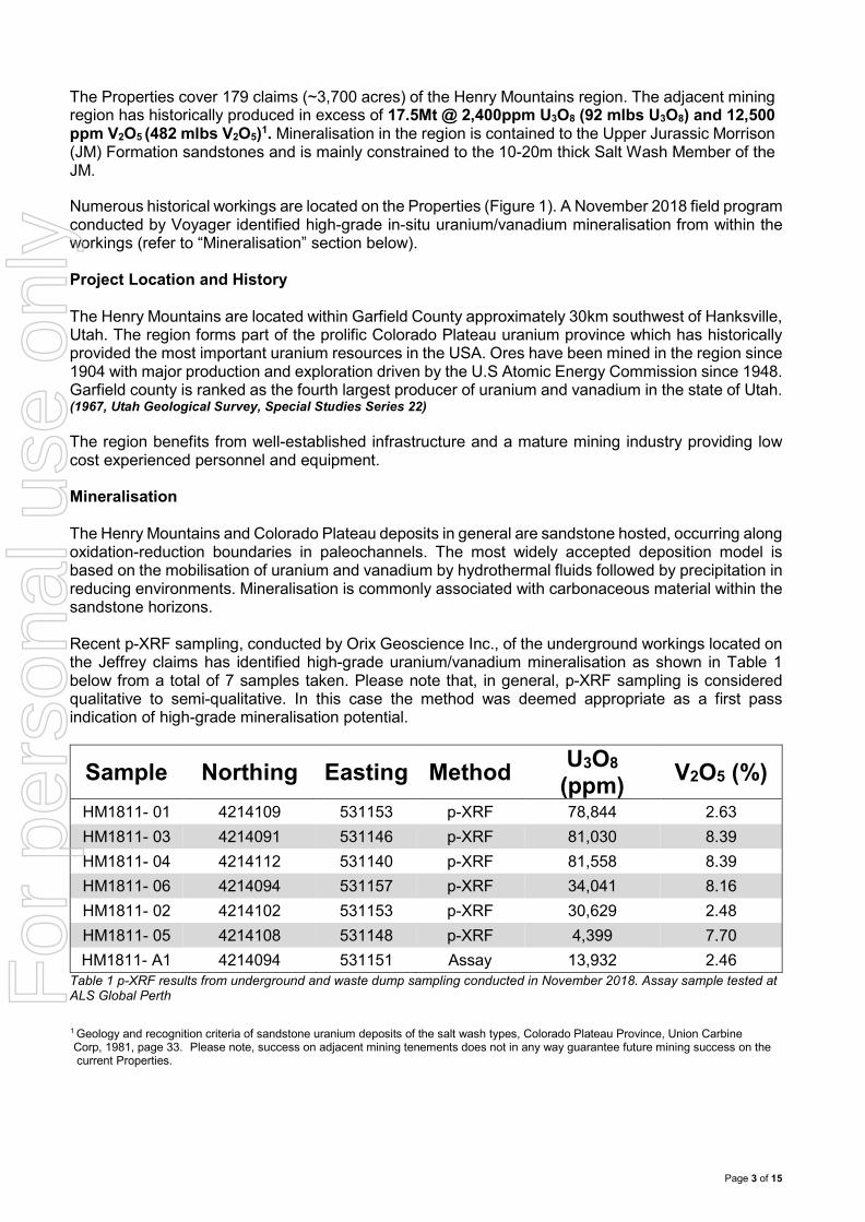
Numerous historical workings are located on the Properties (Figure 1). A November 2018 field program conducted by Voyager identified high-grade in-situ uranium/vanadium mineralisation from within the workings (refer to “Mineralisation” section below). Project Location and History The Henry Mountains are located within Garfield County approximately 30km southwest of Hanksville, Utah. The region forms part of the prolific Colorado Plateau uranium province which has historically provided the most important uranium resources in the USA. Ores have been mined in the region since 1904 with major production and exploration driven by the U.S Atomic Energy Commission since 1948. Garfield county is ranked as the fourth largest producer of uranium and vanadium in the state of Utah. (1967, Utah Geological Survey, Special Studies Series 22) The region benefits from well-established infrastructure and a mature mining industry providing low cost experienced personnel and equipment. Mineralisation The Henry Mountains and Colorado Plateau deposits in general are sandstone hosted, occurring along oxidation-reduction boundaries in paleochannels. The most widely accepted deposition model is based on the mobilisation of uranium and vanadium by hydrothermal fluids followed by precipitation in reducing environments. Mineralisation is commonly associated with carbonaceous material within the sandstone horizons. Recent p-XRF sampling, conducted by Orix Geoscience Inc., of the underground workings located on the Jeffrey claims has identified high-grade uranium/vanadium mineralisation as shown in Table 1 below from a total of 7 samples taken. Please note that, in general, p-XRF sampling is considered qualitative to semi-qualitative. In this case the method was deemed appropriate as a first pass indication of high-grade mineralisation potential.
Table 1 p-XRF results from underground and waste dump sampling conducted in November 2018. Assay sample tested at ALS Global Perth
1 Geology and recognition criteria of sandstone uranium deposits of the salt wash types, Colorado Plateau Province, Union Carbine Corp, 1981, page 33. Please note, success on adjacent mining tenements does not in any way guarantee future mining success on the current Properties.
For
per
sona
l use
onl
y
Page 4 of 15
White Mesa Mill The White Mesa mill is the only conventional fully licensed and operational uranium/vanadium mill in the United States. The mill is owned and operated by Energy Fuels Inc (TSE: EFR) (Energy Fuels) and is located within trucking distance southeast of the Properties. The mill is currently operating at approximately 10% capacity1 and has recently resumed production of V2O5 from its tailings dams to complement its existing uranium processing operations2. Energy Fuels has historically accepted toll milling agreements as well as purchase programs for processing ores from third party mines. This may represent a low-cost opportunity for producers in the region to utilise existing infrastructure, eliminating the significant capital requirement of developing a mill. The mill operates a conventional acid leach process followed by solvent extraction to produce yellow cake and vanadium pentoxide. There is currently no relationship or arrangement in place between Energy Fuels and either the Company or Voyager. Uranium Industry Outlook Nuclear reactors generate approximately 10% of the world’s power, with the US generating 21% of its domestic power from nuclear sources1. Nuclear power provides a stable base load power supply to underpin the variability of renewable sources. To meet the increased requirement of stable base load power supply, a total of 57 new nuclear reactors are under construction worldwide with an additional 134 ordered and 383 proposed2. Uranium demand is forecast to increase by 44% in the next 15 years, however due to the depressed uranium market over the past decade, very few projects have entered the development pipeline leading analysts to predict a major supply shortage in the coming years3 (see Figure 4 below).
Figure 4 Projected uranium supply vs demand 1 World Nuclear Association, World Nuclear Performance report, page 10 2 IAEA power Reactor Information Service 3 World Nuclear Association, World Nuclear Performance report, page 17
Figure 4
For
per
sona
l use
onl
y
Page 5 of 15
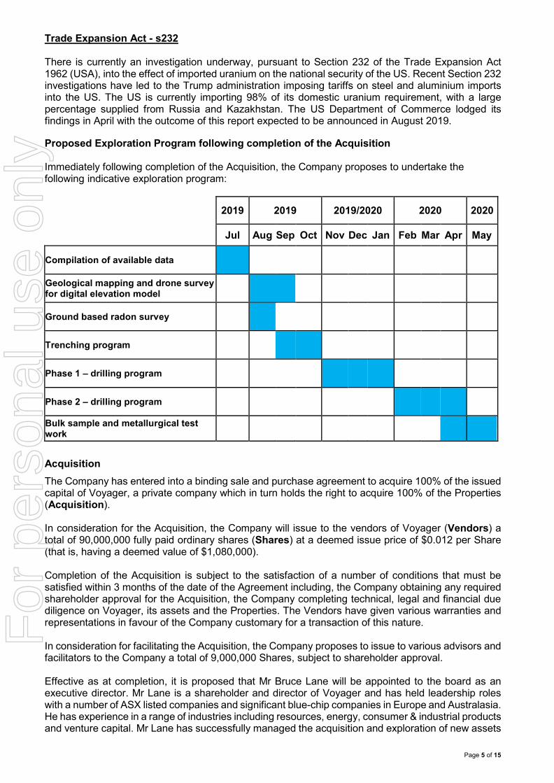
Trade Expansion Act - s232 There is currently an investigation underway, pursuant to Section 232 of the Trade Expansion Act 1962 (USA), into the effect of imported uranium on the national security of the US. Recent Section 232 investigations have led to the Trump administration imposing tariffs on steel and aluminium imports into the US. The US is currently importing 98% of its domestic uranium requirement, with a large percentage supplied from Russia and Kazakhstan. The US Department of Commerce lodged its findings in April with the outcome of this report expected to be announced in August 2019. Proposed Exploration Program following completion of the Acquisition Immediately following completion of the Acquisition, the Company proposes to undertake the following indicative exploration program:
2019 2019 2019/2020 2020 2020
Jul Aug Sep Oct Nov Dec Jan Feb Mar Apr May
Compilation of available data
Geological mapping and drone survey for digital elevation model
Ground based radon survey
Trenching program
Phase 1 – drilling program
Phase 2 – drilling program
Bulk sample and metallurgical test work
Acquisition The Company has entered into a binding sale and purchase agreement to acquire 100% of the issued capital of Voyager, a private company which in turn holds the right to acquire 100% of the Properties (Acquisition). In consideration for the Acquisition, the Company will issue to the vendors of Voyager (Vendors) a total of 90,000,000 fully paid ordinary shares (Shares) at a deemed issue price of $0.012 per Share (that is, having a deemed value of $1,080,000). Completion of the Acquisition is subject to the satisfaction of a number of conditions that must be satisfied within 3 months of the date of the Agreement including, the Company obtaining any required shareholder approval for the Acquisition, the Company completing technical, legal and financial due diligence on Voyager, its assets and the Properties. The Vendors have given various warranties and representations in favour of the Company customary for a transaction of this nature. In consideration for facilitating the Acquisition, the Company proposes to issue to various advisors and facilitators to the Company a total of 9,000,000 Shares, subject to shareholder approval. Effective as at completion, it is proposed that Mr Bruce Lane will be appointed to the board as an executive director. Mr Lane is a shareholder and director of Voyager and has held leadership roles with a number of ASX listed companies and significant blue-chip companies in Europe and Australasia. He has experience in a range of industries including resources, energy, consumer & industrial products and venture capital. Mr Lane has successfully managed the acquisition and exploration of new assets
For
per
sona
l use
onl
y
Page 6 of 15
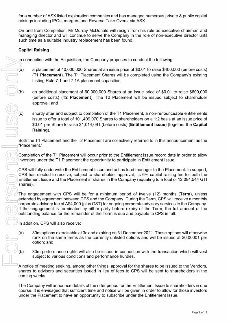
for a number of ASX listed exploration companies and has managed numerous private & public capital raisings including IPOs, mergers and Reverse Take Overs, via ASX. On and from Completion, Mr Murray McDonald will resign from his role as executive chairman and managing director and will continue to serve the Company in the role of non-executive director until such time as a suitable industry replacement has been found. Capital Raising In connection with the Acquisition, the Company proposes to conduct the following: (a) a placement of 40,000,000 Shares at an issue price of $0.01 to raise $400,000 (before costs)
(T1 Placement). The T1 Placement Shares will be completed using the Company’s existing Listing Rule 7.1 and 7.1A placement capacities;
(b) an additional placement of 60,000,000 Shares at an issue price of $0.01 to raise $600,000 (before costs) (T2 Placement). The T2 Placement will be issued subject to shareholder approval; and
(c) shortly after and subject to completion of the T1 Placement, a non-renounceable entitlements
issue to offer a total of 101,409,070 Shares to shareholders on a 1:2 basis at an issue price of $0.01 per Share to raise $1,014,091 (before costs) (Entitlement Issue) (together the Capital Raising).
Both the T1 Placement and the T2 Placement are collectively referred to in this announcement as the “Placement.” Completion of the T1 Placement will occur prior to the Entitlement Issue record date in order to allow investors under the T1 Placement the opportunity to participate in Entitlement Issue. CPS will fully underwrite the Entitlement Issue and act as lead manager to the Placement. In support, CPS has elected to receive, subject to shareholder approval, its 6% capital raising fee for both the Entitlement Issue and the Placement in shares in the Company (equating to a total of 12,084,544 GTI shares). The engagement with CPS will be for a minimum period of twelve (12) months (Term), unless extended by agreement between CPS and the Company. During the Term, CPS will receive a monthly corporate advisory fee of A$4,000 (plus GST) for ongoing corporate advisory services to the Company. If the engagement is terminated by either party before expiry of the Term, the full amount of the outstanding balance for the remainder of the Term is due and payable to CPS in full. In addition, CPS will also receive: (a) 30m options exercisable at 3c and expiring on 31 December 2021. These options will otherwise
rank on the same terms as the currently unlisted options and will be issued at $0.00001 per option; and
(b) 30m performance rights will also be issued in connection with the transaction which will vest
subject to various conditions and performance hurdles. A notice of meeting seeking, among other things, approval for the shares to be issued to the Vendors, shares to advisors and securities issued in lieu of fees to CPS will be sent to shareholders in the coming weeks. The Company will announce details of the offer period for the Entitlement Issue to shareholders in due course. It is envisaged that sufficient time and notice will be given in order to allow for those investors under the Placement to have an opportunity to subscribe under the Entitlement Issue.
For
per
sona
l use
onl
y
Page 7 of 15
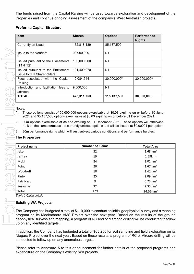
The funds raised from the Capital Raising will be used towards exploration and development of the Properties and continue ongoing assessment of the company’s West Australian projects. Proforma Capital Structure Item Shares Options Performance
Rights Currently on issue 162,818,139
85,137,5001
Issue to the Vendors 90,000,000
Nil
Issued pursuant to the Placements (T1 & T2)
100,000,000
Nil
Issued pursuant to the Entitlement Issue to GTI Shareholders
101,409,070 Nil
Fees associated with the Capital Raising
12,084,544
30,000,0002 30,000,0003
Introduction and facilitation fees to advisors
9,000,000
Nil
TOTAL 475,311,753
115,137,500
30,000,000
Notes: 1. These options consist of 50,000,000 options exercisable at $0.08 expiring on or before 30 June
2021 and 35,137,500 options exercisable at $0.03 expiring on or before 31 December 2021. 2. 30m options exercisable at 3c and expiring on 31 December 2021. These options will otherwise
rank on the same terms as the currently unlisted options and will be issued at $0.00001 per option.
3. 30m performance rights which will vest subject various conditions and performance hurdles.
The Properties
Project name Number of Claims Total Area Jake 32 2.68 km2 Jeffrey 19 1.59km2 Moki 24 2.01 km2 Point 20 1.67 km2 Woodruff 18 1.42 km2 Pinto 25 2.09 km2 Rats Nest 9 0.75 km2 Susannas 32 2.35 km2 Total 179 14.56 km2
Table 2 Claim details
Existing WA Projects The Company has budgeted a total of $119,000 to conduct an initial geophysical survey and a mapping program on its Meekatharra VMS Project over the next year. Based on the results of the ground geophysical surveys and mapping, a program of RC and or diamond drilling will be conducted to follow up on any identified targets. In addition, the Company has budgeted a total of $63,250 for soil sampling and field exploration on its Niagara Project over the next year. Based on these results, a program of RC or Aircore drilling will be conducted to follow up on any anomalous targets. Please refer to Annexure A to this announcement for further details of the proposed programs and expenditure on the Company’s existing WA projects.
For
per
sona
l use
onl
y
Page 8 of 15
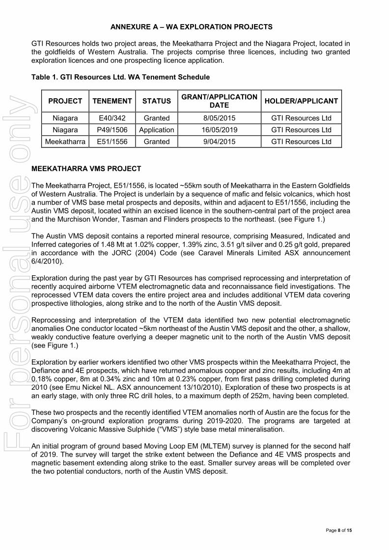
ANNEXURE A – WA EXPLORATION PROJECTS GTI Resources holds two project areas, the Meekatharra Project and the Niagara Project, located in the goldfields of Western Australia. The projects comprise three licences, including two granted exploration licences and one prospecting licence application. Table 1. GTI Resources Ltd. WA Tenement Schedule
PROJECT TENEMENT STATUS GRANT/APPLICATION DATE HOLDER/APPLICANT
Meekatharra E51/1556 Granted 9/04/2015 GTI Resources Ltd MEEKATHARRA VMS PROJECT The Meekatharra Project, E51/1556, is located ~55km south of Meekatharra in the Eastern Goldfields of Western Australia. The Project is underlain by a sequence of mafic and felsic volcanics, which host a number of VMS base metal prospects and deposits, within and adjacent to E51/1556, including the Austin VMS deposit, located within an excised licence in the southern-central part of the project area and the Murchison Wonder, Tasman and Flinders prospects to the northeast. (see Figure 1.) The Austin VMS deposit contains a reported mineral resource, comprising Measured, Indicated and Inferred categories of 1.48 Mt at 1.02% copper, 1.39% zinc, 3.51 g/t silver and 0.25 g/t gold, prepared in accordance with the JORC (2004) Code (see Caravel Minerals Limited ASX announcement 6/4/2010). Exploration during the past year by GTI Resources has comprised reprocessing and interpretation of recently acquired airborne VTEM electromagnetic data and reconnaissance field investigations. The reprocessed VTEM data covers the entire project area and includes additional VTEM data covering prospective lithologies, along strike and to the north of the Austin VMS deposit. Reprocessing and interpretation of the VTEM data identified two new potential electromagnetic anomalies One conductor located ~5km northeast of the Austin VMS deposit and the other, a shallow, weakly conductive feature overlying a deeper magnetic unit to the north of the Austin VMS deposit (see Figure 1.) Exploration by earlier workers identified two other VMS prospects within the Meekatharra Project, the Defiance and 4E prospects, which have returned anomalous copper and zinc results, including 4m at 0.18% copper, 8m at 0.34% zinc and 10m at 0.23% copper, from first pass drilling completed during 2010 (see Emu Nickel NL. ASX announcement 13/10/2010). Exploration of these two prospects is at an early stage, with only three RC drill holes, to a maximum depth of 252m, having been completed. These two prospects and the recently identified VTEM anomalies north of Austin are the focus for the Company’s on-ground exploration programs during 2019-2020. The programs are targeted at discovering Volcanic Massive Sulphide (“VMS”) style base metal mineralisation. An initial program of ground based Moving Loop EM (MLTEM) survey is planned for the second half of 2019. The survey will target the strike extent between the Defiance and 4E VMS prospects and magnetic basement extending along strike to the east. Smaller survey areas will be completed over the two potential conductors, north of the Austin VMS deposit.
For
per
sona
l use
onl
y
Page 9 of 15
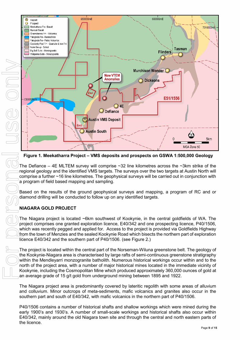
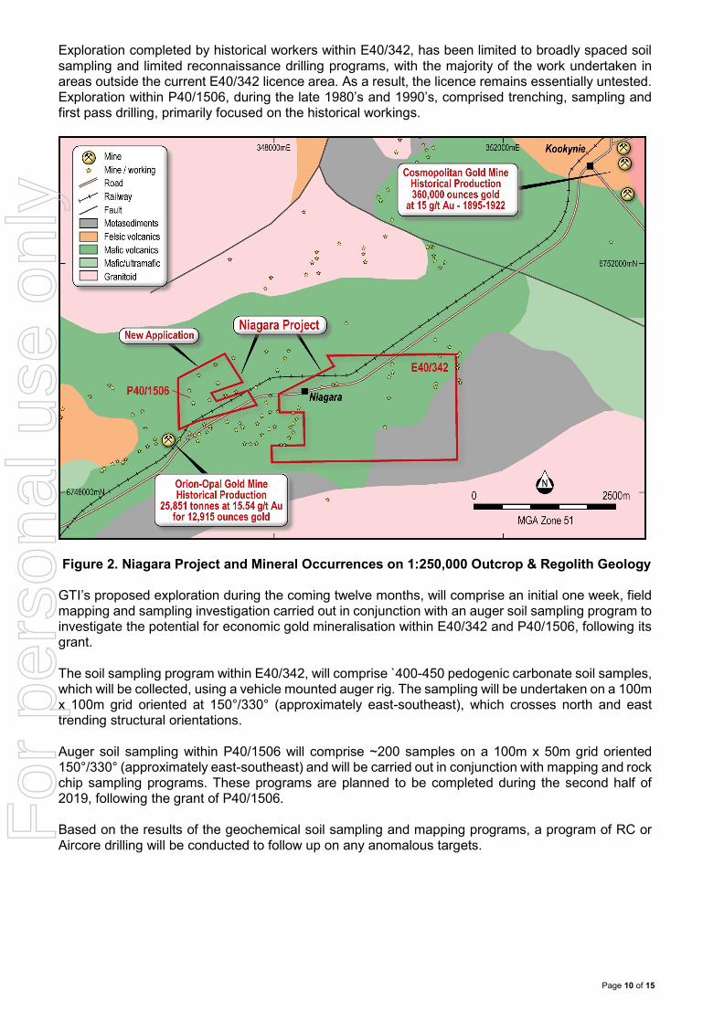
Figure 1. Meekatharra Project – VMS deposits and prospects on GSWA 1:500,000 Geology The Defiance – 4E MLTEM survey will comprise ~32 line kilometres across the ~3km strike of the regional geology and the identified VMS targets. The surveys over the two targets at Austin North will comprise a further ~16 line kilometres. The geophysical surveys will be carried out in conjunction with a program of field based mapping and sampling. Based on the results of the ground geophysical surveys and mapping, a program of RC and or diamond drilling will be conducted to follow up on any identified targets. NIAGARA GOLD PROJECT The Niagara project is located ~6km southwest of Kookynie, in the central goldfields of WA. The project comprises one granted exploration licence, E40/342 and one prospecting licence, P40/1506, which was recently pegged and applied for. Access to the project is provided via Goldfields Highway from the town of Menzies and the sealed Kookynie Road which bisects the northern part of exploration licence E40/342 and the southern part of P40/1506. (see Figure 2.) The project is located within the central part of the Norseman-Wiluna greenstone belt. The geology of the Kookynie-Niagara area is characterised by large rafts of semi-continuous greenstone stratigraphy within the Mendleyarri monzogranite batholith. Numerous historical workings occur within and to the north of the project area, with a number of major historical mines located in the immediate vicinity of Kookynie, including the Cosmopolitan Mine which produced approximately 360,000 ounces of gold at an average grade of 15 g/t gold from underground mining between 1895 and 1922. The Niagara project area is predominantly covered by lateritic regolith with some areas of alluvium and colluvium. Minor outcrops of meta-sediments, mafic volcanics and granites also occur in the southern part and south of E40/342, with mafic volcanics in the northern part of P40/1506. P40/1506 contains a number of historical shafts and shallow workings which were mined during the early 1900’s and 1930’s. A number of small-scale workings and historical shafts also occur within E40/342, mainly around the old Niagara town site and through the central and north eastern parts of the licence.
For
per
sona
l use
onl
y
Page 10 of 15
Exploration completed by historical workers within E40/342, has been limited to broadly spaced soil sampling and limited reconnaissance drilling programs, with the majority of the work undertaken in areas outside the current E40/342 licence area. As a result, the licence remains essentially untested. Exploration within P40/1506, during the late 1980’s and 1990’s, comprised trenching, sampling and first pass drilling, primarily focused on the historical workings.
Figure 2. Niagara Project and Mineral Occurrences on 1:250,000 Outcrop & Regolith Geology
GTI’s proposed exploration during the coming twelve months, will comprise an initial one week, field mapping and sampling investigation carried out in conjunction with an auger soil sampling program to investigate the potential for economic gold mineralisation within E40/342 and P40/1506, following its grant. The soil sampling program within E40/342, will comprise ̀ 400-450 pedogenic carbonate soil samples, which will be collected, using a vehicle mounted auger rig. The sampling will be undertaken on a 100m x 100m grid oriented at 150°/330° (approximately east-southeast), which crosses north and east trending structural orientations. Auger soil sampling within P40/1506 will comprise ~200 samples on a 100m x 50m grid oriented 150°/330° (approximately east-southeast) and will be carried out in conjunction with mapping and rock chip sampling programs. These programs are planned to be completed during the second half of 2019, following the grant of P40/1506. Based on the results of the geochemical soil sampling and mapping programs, a program of RC or Aircore drilling will be conducted to follow up on any anomalous targets.
For
per
sona
l use
onl
y
Page 11 of 15
Murray McDonald Executive Chairman Competent Persons Statement The information in this announcement that relates to the historical Exploration Results on the Properties is based on information compiled and fairly represented by Mr Craig Fitchett who is a member of the Association of Professional Geoscientists of Ontario. Mr Fitchett is a senior project geologist for Orix Geoscience Inc. with over 10 years’ experience. Mr Fitchett has sufficient experience relevant to the style of mineralisation and type of deposit under consideration, and to the activity which has been undertaken in 2018, to qualify as a Competent Person as defined in the 2012 Edition of the Joint Ore Reserves Committee (JORC) Australasian Code for Reporting of exploration results, Mineral Resources and Ore Reserves. Mr Fitchett provides his consent to the inclusion in this report of the matter based on this information in the form and context in which it appears.
For
per
sona
l use
onl
y
Page 12 of 15
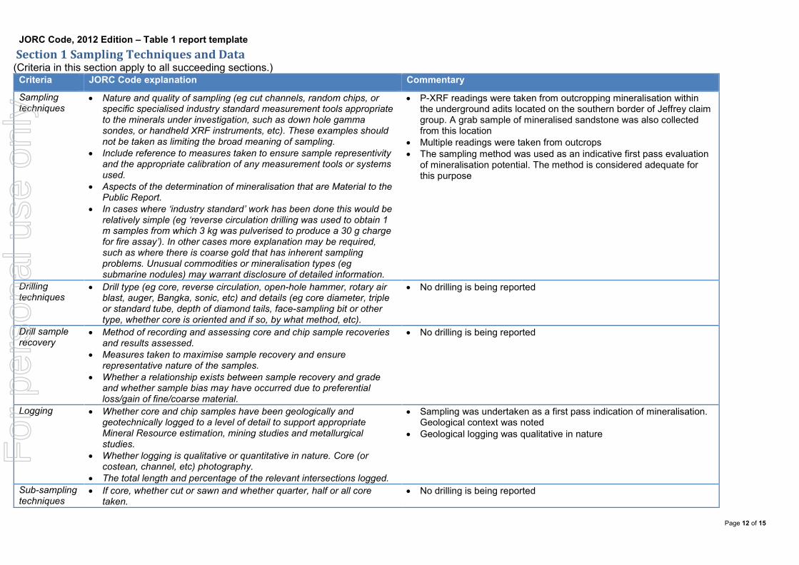
JORC Code, 2012 Edition – Table 1 report template Section 1 Sampling Techniques and Data (Criteria in this section apply to all succeeding sections.)
Criteria JORC Code explanation Commentary
Sampling techniques
• Nature and quality of sampling (eg cut channels, random chips, or specific specialised industry standard measurement tools appropriate to the minerals under investigation, such as down hole gamma sondes, or handheld XRF instruments, etc). These examples should not be taken as limiting the broad meaning of sampling.
• Include reference to measures taken to ensure sample representivity and the appropriate calibration of any measurement tools or systems used.
• Aspects of the determination of mineralisation that are Material to the Public Report.
• In cases where ‘industry standard’ work has been done this would be relatively simple (eg ‘reverse circulation drilling was used to obtain 1 m samples from which 3 kg was pulverised to produce a 30 g charge for fire assay’). In other cases more explanation may be required, such as where there is coarse gold that has inherent sampling problems. Unusual commodities or mineralisation types (eg submarine nodules) may warrant disclosure of detailed information.
• P-XRF readings were taken from outcropping mineralisation within the underground adits located on the southern border of Jeffrey claim group. A grab sample of mineralised sandstone was also collected from this location
• Multiple readings were taken from outcrops • The sampling method was used as an indicative first pass evaluation
of mineralisation potential. The method is considered adequate for this purpose
Drilling techniques
• Drill type (eg core, reverse circulation, open-hole hammer, rotary air blast, auger, Bangka, sonic, etc) and details (eg core diameter, triple or standard tube, depth of diamond tails, face-sampling bit or other type, whether core is oriented and if so, by what method, etc).
• No drilling is being reported
Drill sample recovery
• Method of recording and assessing core and chip sample recoveries and results assessed.
• Measures taken to maximise sample recovery and ensure representative nature of the samples.
• Whether a relationship exists between sample recovery and grade and whether sample bias may have occurred due to preferential loss/gain of fine/coarse material.
• No drilling is being reported
Logging • Whether core and chip samples have been geologically and geotechnically logged to a level of detail to support appropriate Mineral Resource estimation, mining studies and metallurgical studies.
• Whether logging is qualitative or quantitative in nature. Core (or costean, channel, etc) photography.
• The total length and percentage of the relevant intersections logged.
• Sampling was undertaken as a first pass indication of mineralisation. Geological context was noted
• Geological logging was qualitative in nature
Sub-sampling techniques
• If core, whether cut or sawn and whether quarter, half or all core taken.
• No drilling is being reported
For
per
sona
l use
onl
y
Page 13 of 15
Criteria JORC Code explanation Commentary
and sample preparation
• If non-core, whether riffled, tube sampled, rotary split, etc and whether sampled wet or dry.
• For all sample types, the nature, quality and appropriateness of the sample preparation technique.
• Quality control procedures adopted for all sub-sampling stages to maximise representivity of samples.
• Measures taken to ensure that the sampling is representative of the in situ material collected, including for instance results for field duplicate/second-half sampling.
• Whether sample sizes are appropriate to the grain size of the material being sampled.
• The sampling techniques are appropriate as a first pass estimation of mineralisation potential
• Multiple readings taken from outcropping mineralisation within the underground workings
• The material and sample sizes are considered appropriate given the style of mineralisation being targeted
Quality of assay data and laboratory tests
• The nature, quality and appropriateness of the assaying and laboratory procedures used and whether the technique is considered partial or total.
• For geophysical tools, spectrometers, handheld XRF instruments, etc, the parameters used in determining the analysis including instrument make and model, reading times, calibrations factors applied and their derivation, etc.
• Nature of quality control procedures adopted (eg standards, blanks, duplicates, external laboratory checks) and whether acceptable levels of accuracy (ie lack of bias) and precision have been established.
• The sampling procedure is indicative of mineralisation potential only • The instrument used was a Bruker S1 portable x-ray fluorescence
spectrometer, using reading times of 30s, 10s for each angle. No calibration factors were applied
• Sampling is indicative of mineralisation potential only, accuracy of determination is limited by spectrometer accuracy
• The grab sample was assayed at ALS Global Perth
Verification of sampling and assaying
• The verification of significant intersections by either independent or alternative company personnel.
• The use of twinned holes. • Documentation of primary data, data entry procedures, data
verification, data storage (physical and electronic) protocols. • Discuss any adjustment to assay data.
• No Drilling reported • Primary data collected in the field and entered into database • No adjustments made to assay data
Location of data points
• Accuracy and quality of surveys used to locate drill holes (collar and down-hole surveys), trenches, mine workings and other locations used in Mineral Resource estimation.
• Specification of the grid system used. • Quality and adequacy of topographic control.
• N/A
Data spacing and distribution
• Data spacing for reporting of Exploration Results. • Whether the data spacing and distribution is sufficient to establish the
degree of geological and grade continuity appropriate for the Mineral Resource and Ore Reserve estimation procedure(s) and classifications applied.
• Whether sample compositing has been applied.
• Sampling was conducted on an ad hoc basis • No compositing has been applied
For
per
sona
l use
onl
y
Page 14 of 15
Criteria JORC Code explanation Commentary
Orientation of data in relation to geological structure
• Whether the orientation of sampling achieves unbiased sampling of possible structures and the extent to which this is known, considering the deposit type.
• If the relationship between the drilling orientation and the orientation of key mineralised structures is considered to have introduced a sampling bias, this should be assessed and reported if material.
• No drilling reported
Sample security
• The measures taken to ensure sample security. • Not Applicable
Audits or reviews
• The results of any audits or reviews of sampling techniques and data. • No audits or reviews reported
Section 2 Reporting of Exploration Results (Criteria listed in the preceding section also apply to this section.)
Criteria JORC Code explanation Commentary
Mineral tenement and land tenure status
• Type, reference name/number, location and ownership including agreements or material issues with third parties such as joint ventures, partnerships, overriding royalties, native title interests, historical sites, wilderness or national park and environmental settings.
• The security of the tenure held at the time of reporting along with any known impediments to obtaining a licence to operate in the area.
• The projects combined cover 14.58 km2 over 179 claims located in Utah, USA
• All claims are in good standing
Exploration done by other parties
• Acknowledgment and appraisal of exploration by other parties. • Pas exploration in the region was for uranium and vanadium mineralisation.
Geology • Deposit type, geological setting and style of mineralisation. • Uranium and Vanadium mineralisation occurs in 5 sandstone units of the Morrison formation. With the majority of historical production generated from the Salt Wash member of the Morrison Formation
Drill hole Information
• A summary of all information material to the understanding of the exploration results including a tabulation of the following information for all Material drill holes: o easting and northing of the drill hole collar o elevation or RL (Reduced Level – elevation above sea level in
metres) of the drill hole collar o dip and azimuth of the hole o down hole length and interception depth o hole length.
• If the exclusion of this information is justified on the basis that the information is not Material and this exclusion does not detract from
• No drilling reported
For
per
sona
l use
onl
y
Page 15 of 15
Criteria JORC Code explanation Commentary
the understanding of the report, the Competent Person should clearly explain why this is the case.
Data aggregation methods
• In reporting Exploration Results, weighting averaging techniques, maximum and/or minimum grade truncations (eg cutting of high grades) and cut-off grades are usually Material and should be stated.
• Where aggregate intercepts incorporate short lengths of high grade results and longer lengths of low grade results, the procedure used for such aggregation should be stated and some typical examples of such aggregations should be shown in detail.
• The assumptions used for any reporting of metal equivalent values should be clearly stated.
• Not Applicable, information has been included
Relationship between mineralisation widths and intercept lengths
• These relationships are particularly important in the reporting of Exploration Results.
• If the geometry of the mineralisation with respect to the drill hole angle is known, its nature should be reported.
• If it is not known and only the down hole lengths are reported, there should be a clear statement to this effect (eg ‘down hole length, true width not known’).
• No Drilling reported
Diagrams • Appropriate maps and sections (with scales) and tabulations of intercepts should be included for any significant discovery being reported These should include, but not be limited to a plan view of drill hole collar locations and appropriate sectional views.
• Appropriate diagrams shown
Balanced reporting
• Where comprehensive reporting of all Exploration Results is not practicable, representative reporting of both low and high grades and/or widths should be practiced to avoid misleading reporting of Exploration Results.
• All available results have been reported
Other substantive exploration data
• Other exploration data, if meaningful and material, should be reported including (but not limited to): geological observations; geophysical survey results; geochemical survey results; bulk samples – size and method of treatment; metallurgical test results; bulk density, groundwater, geotechnical and rock characteristics; potential deleterious or contaminating substances.
• All available results have been reported
Further work • The nature and scale of planned further work (eg tests for lateral extensions or depth extensions or large-scale step-out drilling).
• Diagrams clearly highlighting the areas of possible extensions, including the main geological interpretations and future drilling areas, provided this information is not commercially sensitive.
• Further work suggested included, radiological surveys, underground and surface mapping, further sampling and trenching followed by drilling programs and bulk sampling for metallurgical testing