(L) Less than 500 acres USFS-USDA Forest Service Sources: Teal Data Center Ownership (Govtown 1999)
Totals may not add due to rounding BLM—Bureau of Land Management FRAP Multi source landcover data v. 02_1 (Fveg 02_1g. 2002) Water not broken down by ownership NPS—National Park Service
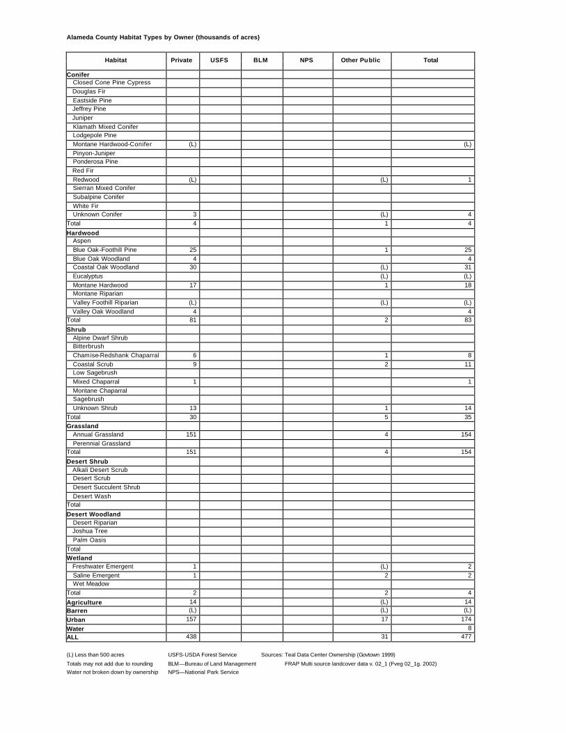
Alameda County Habitat Types by Owner (thousands of acres)
Habitat Private USFS BLM NPS Other Public Total
Conifer Closed Cone Pine Cypress Douglas Fir Eastside Pine Jeffrey Pine Juniper Klamath Mixed Conifer Lodgepole Pine Montane Hardwood-Conifer (L) (L) Pinyon-Juniper Ponderosa Pine Red Fir Redwood (L) (L) 1 Sierran Mixed Conifer Subalpine Conifer White Fir Unknown Conifer 3 (L) 4 Total 4 1 4
Hardwood Aspen Blue Oak-Foothill Pine 25 1 25 Blue Oak Woodland 4 4 Coastal Oak Woodland 30 (L) 31 Eucalyptus (L) (L) Montane Hardwood 17 1 18 Montane Riparian Valley Foothill Riparian (L) (L) (L) Valley Oak Woodland 4 4 Total 81 2 83
Desert Woodland Desert Riparian Joshua Tree Palm Oasis Total Wetland Freshwater Emergent 1 (L) 2 Saline Emergent 1 2 2 Wet Meadow Total 2 2 4
Agriculture 14 (L) 14 Barren (L) (L) (L)
Urban 157 17 174
Water 8 ALL 438 31 477
(L) Less than 500 acres USFS-USDA Forest Service Sources: Teal Data Center Ownership (Govtown 1999)
Totals may not add due to rounding BLM—Bureau of Land Management FRAP Multi source landcover data v. 02_1 (Fveg 02_1g. 2002) Water not broken down by ownership NPS—National Park Service
Alpine County Habitat Types by Owner (thousands of acres)
Habitat Private USFS BLM NPS Other Public Total
Conifer Closed Cone Pine Cypress Douglas Fir Eastside Pine Jeffrey Pine 2 26 (L) 1 29 Juniper Klamath Mixed Conifer
Lodgepole Pine 1 42 (L) 43 Montane Hardwood-Conifer (L) (L) Pinyon-Juniper 2 14 2 (L) 17 Ponderosa Pine (L) (L) Red Fir 3 58 1 62 Redwood Sierran Mixed Conifer 10 59 7 2 77 Subalpine Conifer 2 20 4 1 26 White Fir (L) 1 (L) 1 Unknown Conifer Total 19 219 13 4 255
Hardwood Aspen (L) 2 (L) (L) 3 Blue Oak-Foothill Pine Blue Oak Woodland Coastal Oak Woodland Eucalyptus Montane Hardwood 1 1 Montane Riparian (L) (L) (L) (L) (L) Valley Foothill Riparian Valley Oak Woodland Total 1 3 (L) (L) 4 Shrub Alpine Dwarf Shrub 3 3 Bitterbrush 2 1 1 (L) 3 Chamise-Redshank Chaparral Coastal Scrub Low Sagebrush (L) (L) Mixed Chaparral (L) (L) Montane Chaparral 3 29 (L) 1 34 Sagebrush 3 70 1 1 76 Unknown Shrub Total 9 104 2 2 116
Grassland Annual Grassland 2 5 3 1 11 Perennial Grassland Total 2 5 3 1 11 Desert Shrub Alkali Desert Scrub Desert Scrub Desert Succulent Shrub Desert Wash Total Desert Woodland Desert Riparian Joshua Tree Palm Oasis Total
(L) Less than 500 acres USFS-USDA Forest Service Sources: Teal Data Center Ownership (Govtown 1999)
Totals may not add due to rounding BLM—Bureau of Land Management FRAP Multi source landcover data v. 02_1 (Fveg 02_1g. 2002) Water not broken down by ownership NPS—National Park Service
Amador County Habitat Types by Owner (thousands of acres)
Habitat Private USFS BLM NPS Other Public Total
Conifer Closed Cone Pine Cypress (L) (L) Douglas Fir 3 1 (L) 4 Eastside Pine Jeffrey Pine (L) 1 1 Juniper Klamath Mixed Conifer Lodgepole Pine (L) (L) (L) Montane Hardwood-Conifer 17 2 2 (L) 21 Pinyon-Juniper Ponderosa Pine 18 2 1 (L) 20 Red Fir 2 28 31 Redwood Sierran Mixed Conifer 22 19 (L) (L) 41 Subalpine Conifer 1 1 White Fir (L) 3 3 Unknown Conifer Total 62 57 2 (L) 121
Hardwood Aspen Blue Oak-Foothill Pine 4 (L) (L) 4 Blue Oak Woodland 45 (L) (L) 45 Coastal Oak Woodland Eucalyptus Montane Hardwood 62 4 4 1 70 Montane Riparian (L) (L) (L) 1 Valley Foothill Riparian (L) (L) Valley Oak Woodland 1 (L) 1 Total 112 4 4 1 121
Desert Woodland Desert Riparian Joshua Tree Palm Oasis Total Wetland Freshwater Emergent (L) (L) Saline Emergent Wet Meadow (L) 1 1 Total (L) 1 1
Agriculture 11 (L) (L) 11 Barren 2 9 (L) (L) 11
Urban 8 (L) (L) 1 10
Water 8 ALL 291 77 9 3 387
(L) Less than 500 acres USFS-USDA Forest Service Sources: Teal Data Center Ownership (Govtown 1999) Totals may not add due to rounding BLM—Bureau of Land Management FRAP Multi source landcover data v. 02_1 (Fveg 02_1g. 2002)
Water not broken down by ownership NPS—National Park Service
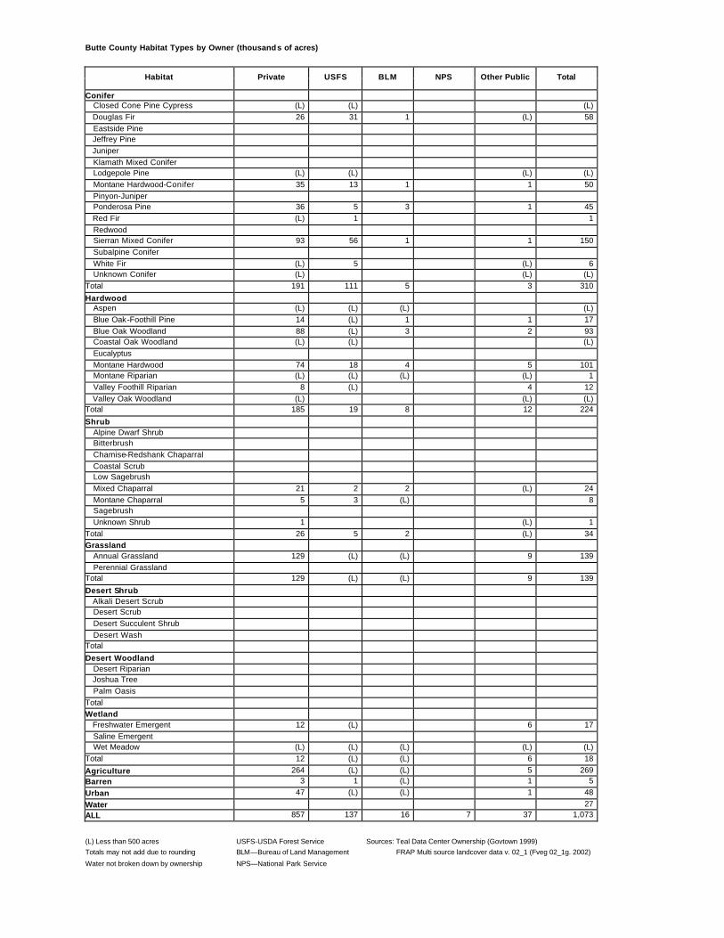
Butte County Habitat Types by Owner (thousands of acres)
Habitat Private USFS BLM NPS Other Public Total
Conifer Closed Cone Pine Cypress (L) (L) (L) Douglas Fir 26 31 1 (L) 58 Eastside Pine Jeffrey Pine Juniper Klamath Mixed Conifer Lodgepole Pine (L) (L) (L) (L) Montane Hardwood-Conifer 35 13 1 1 50 Pinyon-Juniper Ponderosa Pine 36 5 3 1 45 Red Fir (L) 1 1 Redwood Sierran Mixed Conifer 93 56 1 1 150 Subalpine Conifer White Fir (L) 5 (L) 6 Unknown Conifer (L) (L) (L) Total 191 111 5 3 310
Hardwood Aspen (L) (L) (L) (L) Blue Oak-Foothill Pine 14 (L) 1 1 17 Blue Oak Woodland 88 (L) 3 2 93 Coastal Oak Woodland (L) (L) (L) Eucalyptus Montane Hardwood 74 18 4 5 101 Montane Riparian (L) (L) (L) (L) 1 Valley Foothill Riparian 8 (L) 4 12 Valley Oak Woodland (L) (L) (L) Total 185 19 8 12 224
(L) Less than 500 acres USFS-USDA Forest Service Sources: Teal Data Center Ownership (Govtown 1999) Totals may not add due to rounding BLM—Bureau of Land Management FRAP Multi source landcover data v. 02_1 (Fveg 02_1g. 2002)
Water not broken down by ownership NPS—National Park Service
Calaveras County Habitat Types by Owner (thousands of acres)
Habitat Private USFS BLM NPS Other Public Total
Conifer Closed Cone Pine Cypress Douglas Fir 6 2 3 (L) 11 Eastside Pine Jeffrey Pine (L) 2 2 Juniper Klamath Mixed Conifer Lodgepole Pine 1 3 4 Montane Hardwood-Conifer 77 3 7 2 91 Pinyon-Juniper Ponderosa Pine 39 8 5 1 53 Red Fir (L) 5 6 Redwood Sierran Mixed Conifer 53 39 (L) 2 94 Subalpine Conifer White Fir Unknown Conifer (L) (L) (L) Total 177 63 15 5 261
Hardwood Aspen Blue Oak-Foothill Pine 2 (L) (L) (L) 2 Blue Oak Woodland 52 1 2 55 Coastal Oak Woodland Eucalyptus Montane Hardwood 87 6 6 3 102 Montane Riparian (L) (L) (L) Valley Foothill Riparian Valley Oak Woodland Total 141 6 8 5 159
Desert Woodland Desert Riparian Joshua Tree Palm Oasis Total Wetland Freshwater Emergent Saline Emergent Wet Meadow (L) (L) (L) (L) Total (L) (L) (L) (L)
Agriculture 1 (L) (L) 1 Barren 2 1 (L) (L) 3
Urban 5 (L) (L) (L) 5
Water 17 ALL 516 80 35 15 663
(L) Less than 500 acres USFS-USDA Forest Service Sources: Teal Data Center Ownership (Govtown 1999) Totals may not add due to rounding BLM—Bureau of Land Management FRAP Multi source landcover data v. 02_1 (Fveg 02_1g. 2002)
Water not broken down by ownership NPS—National Park Service
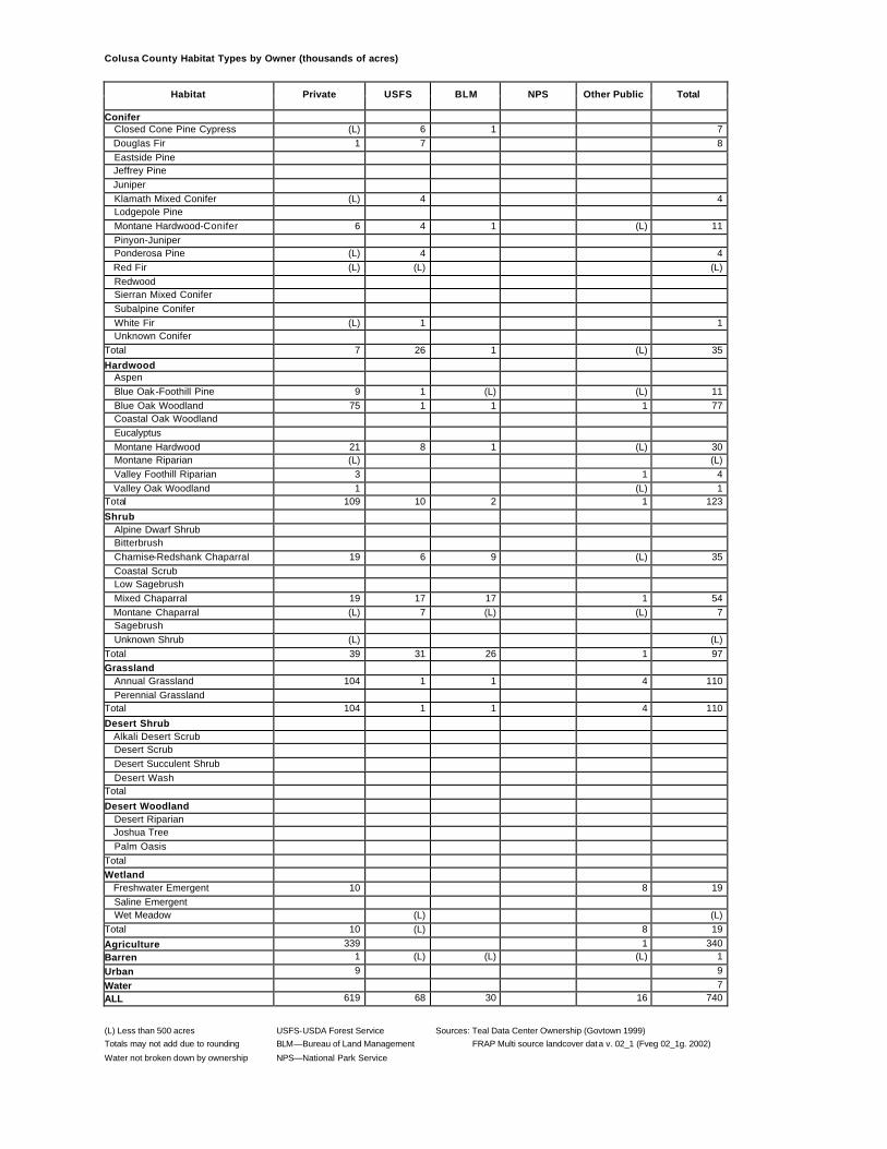
Colusa County Habitat Types by Owner (thousands of acres)
Habitat Private USFS BLM NPS Other Public Total
Conifer Closed Cone Pine Cypress (L) 6 1 7 Douglas Fir 1 7 8 Eastside Pine Jeffrey Pine Juniper Klamath Mixed Conifer (L) 4 4 Lodgepole Pine Montane Hardwood-Conifer 6 4 1 (L) 11 Pinyon-Juniper Ponderosa Pine (L) 4 4 Red Fir (L) (L) (L) Redwood Sierran Mixed Conifer Subalpine Conifer White Fir (L) 1 1 Unknown Conifer Total 7 26 1 (L) 35
Hardwood Aspen Blue Oak-Foothill Pine 9 1 (L) (L) 11 Blue Oak Woodland 75 1 1 1 77 Coastal Oak Woodland Eucalyptus Montane Hardwood 21 8 1 (L) 30 Montane Riparian (L) (L) Valley Foothill Riparian 3 1 4 Valley Oak Woodland 1 (L) 1 Total 109 10 2 1 123
Desert Woodland Desert Riparian Joshua Tree Palm Oasis Total Wetland Freshwater Emergent 10 8 19 Saline Emergent Wet Meadow (L) (L) Total 10 (L) 8 19
Agriculture 339 1 340 Barren 1 (L) (L) (L) 1
Urban 9 9
Water 7 ALL 619 68 30 16 740
(L) Less than 500 acres USFS-USDA Forest Service Sources: Teal Data Center Ownership (Govtown 1999) Totals may not add due to rounding BLM—Bureau of Land Management FRAP Multi source landcover data v. 02_1 (Fveg 02_1g. 2002)
Water not broken down by ownership NPS—National Park Service
Contra Costa County Habitat Types by Owner (thousands of acres)
Habitat Private USFS BLM NPS Other Public Total
Conifer Closed Cone Pine Cypress (L) (L) Douglas Fir Eastside Pine Jeffrey Pine Juniper Klamath Mixed Conifer Lodgepole Pine Montane Hardwood-Conifer Pinyon-Juniper Ponderosa Pine Red Fir Redwood (L) (L) 1 Sierran Mixed Conifer Subalpine Conifer White Fir Unknown Conifer 1 (L) 1 Total 1 1 2
Hardwood Aspen Blue Oak-Foothill Pine (L) (L) 1 Blue Oak Woodland 10 2 12 Coastal Oak Woodland 19 3 22 Eucalyptus (L) (L) Montane Hardwood 2 (L) 2 Montane Riparian Valley Foothill Riparian 1 (L) 1 Valley Oak Woodland 1 (L) 1 Total 33 6 39
Desert Woodland Desert Riparian Joshua Tree Palm Oasis Total Wetland Freshwater Emergent 3 1 5 Saline Emergent 3 (L) 3 Wet Meadow Total 6 2 7
Agriculture 65 (L) 65 Barren (L) (L) (L)
Urban 152 4 156
Water 13 ALL 419 (L) 43 475
(L) Less than 500 acres USFS-USDA Forest Service Sources: Teal Data Center Ownership (Govtown 1999) Totals may not add due to rounding BLM—Bureau of Land Management FRAP Multi source landcover data v. 02_1 (Fveg 02_1g. 2002)
Water not broken down by ownership NPS—National Park Service
Del Norte County Habitat Types by Owner (thousands of acres)
Habitat Private USFS BLM NPS Other Public Total
Conifer Closed Cone Pine Cypress (L) (L) Douglas Fir 26 142 1 2 171 Eastside Pine Jeffrey Pine (L) 3 (L) 3 Juniper Klamath Mixed Conifer 6 101 (L) (L) 107 Lodgepole Pine Montane Hardwood-Conifer 24 68 (L) 1 94 Pinyon-Juniper Ponderosa Pine (L) (L) Red Fir 3 3 Redwood 22 1 4 17 42 Sierran Mixed Conifer Subalpine Conifer 1 1 White Fir 18 18 Unknown Conifer Total 78 336 5 20 439
Hardwood Aspen Blue Oak-Foothill Pine Blue Oak Woodland Coastal Oak Woodland (L) (L) Eucalyptus Montane Hardwood 45 33 1 4 83 Montane Riparian 16 4 1 5 26 Valley Foothill Riparian Valley Oak Woodland Total 61 37 2 9 110
Desert Woodland Desert Riparian Joshua Tree Palm Oasis Total Wetland Freshwater Emergent Saline Emergent (L) (L) 1 Wet Meadow (L) (L) Total (L) (L) (L) 1
Agriculture 11 (L) (L) 11 Barren 2 3 (L) 1 6
Urban 8 (L) (L) 1 9
Water 5 ALL 176 425 (L) 8 34 649
(L) Less than 500 acres USFS-USDA Forest Service Sources: Teal Data Center Ownership (Govtown 1999) Totals may not add due to rounding BLM—Bureau of Land Management FRAP Multi source landcover data v. 02_1 (Fveg 02_1g. 2002)
Water not broken down by ownership NPS—National Park Service
El Dorado County Habitat Types by Owner (thousands of acres)
Habitat Private USFS BLM NPS Other Public Total
Conifer Closed Cone Pine Cypress (L) (L) Douglas Fir 30 35 2 1 67 Eastside Pine Jeffrey Pine 5 9 1 15 Juniper Klamath Mixed Conifer Lodgepole Pine 2 22 (L) 25 Montane Hardwood-Conifer 35 9 2 1 47 Pinyon-Juniper Ponderosa Pine 38 30 2 (L) 70 Red Fir 8 81 (L) 89 Redwood Sierran Mixed Conifer 103 184 (L) 4 291 Subalpine Conifer (L) 5 5 White Fir 5 19 (L) 25 Unknown Conifer Total 226 395 6 8 634
Hardwood Aspen (L) (L) (L) (L) Blue Oak-Foothill Pine 3 (L) (L) (L) 4 Blue Oak Woodland 38 (L) 1 2 41 Coastal Oak Woodland Eucalyptus (L) (L) Montane Hardwood 127 10 10 3 150 Montane Riparian 1 (L) (L) 1 Valley Foothill Riparian Valley Oak Woodland 3 (L) (L) 3 Total 172 11 11 5 198
(L) Less than 500 acres USFS-USDA Forest Service Sources: Teal Data Center Ownership (Govtown 1999) Totals may not add due to rounding BLM—Bureau of Land Management FRAP Multi source landcover data v. 02_1 (Fveg 02_1g. 2002)
Water not broken down by ownership NPS—National Park Service
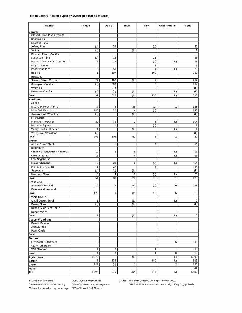
Fresno County Habitat Types by Owner (thousands of acres)
Habitat Private USFS BLM NPS Other Public Total
Conifer Closed Cone Pine Cypress Douglas Fir Eastside Pine Jeffrey Pine (L) 35 (L) 36 Juniper (L) (L) 1 Klamath Mixed Conifer Lodgepole Pine (L) 15 21 36 Montane Hardwood-Conifer 3 13 (L) (L) 16 Pinyon-Juniper 2 2 Ponderosa Pine 10 59 4 (L) 73 Red Fir 1 107 108 216 Redwood Sierran Mixed Conifer 22 190 (L) 7 219 Subalpine Conifer (L) 206 8 214 White Fir (L) (L) Unknown Conifer (L) (L) (L) (L) (L) Total 37 625 (L) 150 (L) 813
Hardwood Aspen Blue Oak-Foothill Pine 87 3 36 (L) 1 128 Blue Oak Woodland 152 30 4 (L) 1 187 Coastal Oak Woodland (L) (L) (L) Eucalyptus Montane Hardwood 29 72 1 1 (L) 104 Montane Riparian 1 (L) 1 Valley Foothill Riparian 1 (L) (L) 1 Valley Oak Woodland (L) (L) Total 269 106 41 2 2 420
(L) Less than 500 acres USFS-USDA Forest Service Sources: Teal Data Center Ownership (Govtown 1999) Totals may not add due to rounding BLM—Bureau of Land Management FRAP Multi source landcover data v. 02_1 (Fveg 02_1g. 2002)
Water not broken down by ownership NPS—National Park Service
Glenn County Habitat Types by Owner (thousands of acres)
Habitat Private USFS BLM NPS Other Public Total
Conifer Closed Cone Pine Cypress (L) 5 5 Douglas Fir 3 24 27 Eastside Pine Jeffrey Pine Juniper Klamath Mixed Conifer 4 17 21 Lodgepole Pine Montane Hardwood-Conifer 3 6 (L) 8 Pinyon-Juniper Ponderosa Pine 3 17 19 Red Fir (L) 1 1 Redwood Sierran Mixed Conifer Subalpine Conifer White Fir 2 7 9 Unknown Conifer Total 14 75 (L) 89
Hardwood Aspen Blue Oak-Foothill Pine 6 1 (L) (L) 7 Blue Oak Woodland 60 2 (L) 1 63 Coastal Oak Woodland Eucalyptus Montane Hardwood 11 34 1 (L) 45 Montane Riparian (L) (L) Valley Foothill Riparian 3 1 4 Valley Oak Woodland 2 (L) 2 Total 82 37 1 2 122
Desert Woodland Desert Riparian Joshua Tree Palm Oasis Total Wetland Freshwater Emergent 4 6 11 Saline Emergent Wet Meadow (L) (L) (L) Total 4 (L) 6 11
Agriculture 273 (L) 4 277 Barren 4 (L) (L) 5
Urban 9 (L) (L) 9
Water 9 ALL 625 194 4 17 849
(L) Less than 500 acres USFS-USDA Forest Service Sources: Teal Data Center Ownership (Govtown 1999) Totals may not add due to rounding BLM—Bureau of Land Management FRAP Multi source landcover data v. 02_1 (Fveg 02_1g. 2002)
Water not broken down by ownership NPS—National Park Service
Humboldt County Habitat Types by Owner (thousands of acres)
Habitat Private USFS BLM NPS Other Public Total
Conifer Closed Cone Pine Cypress (L) (L) (L) (L) 1 Douglas Fir 418 148 55 1 70 692 Eastside Pine Jeffrey Pine (L) 2 (L) (L) 2 Juniper Klamath Mixed Conifer 4 14 (L) (L) 1 19 Lodgepole Pine Montane Hardwood-Conifer 90 61 1 4 10 166 Pinyon-Juniper Ponderosa Pine (L) (L) (L) Red Fir (L) 7 7 Redwood 342 (L) (L) 40 43 424 Sierran Mixed Conifer Subalpine Conifer (L) (L) White Fir 2 30 1 32 Unknown Conifer (L) (L) Total 857 261 56 45 125 1,343
Hardwood Aspen Blue Oak-Foothill Pine (L) (L) Blue Oak Woodland Coastal Oak Woodland 25 (L) 1 6 33 Eucalyptus (L) (L) Montane Hardwood 353 38 9 15 53 469 Montane Riparian 34 4 (L) 7 4 49 Valley Foothill Riparian Valley Oak Woodland Total 413 42 10 23 64 551
Desert Woodland Desert Riparian Joshua Tree Palm Oasis Total Wetland Freshwater Emergent 1 (L) 1 Saline Emergent 6 2 8 Wet Meadow (L) (L) (L) Total 7 (L) 2 9
Agriculture 41 1 41 Barren 21 2 2 (L) 3 28
Urban 28 (L) (L) (L) 4 32
Water 10 ALL 1,599 334 75 70 204 2,293
(L) Less than 500 acres USFS-USDA Forest Service Sources: Teal Data Center Ownership (Govtown 1999) Totals may not add due to rounding BLM—Bureau of Land Management FRAP Multi source landcover data v. 02_1 (Fveg 02_1g. 2002)
Water not broken down by ownership NPS—National Park Service
Imperial County Habitat Types by Owner (thousands of acres)
Habitat Private USFS BLM NPS Other Public Total
Conifer Closed Cone Pine Cypress Douglas Fir Eastside Pine Jeffrey Pine Juniper 3 5 (L) 8 Klamath Mixed Conifer Lodgepole Pine Montane Hardwood-Conifer Pinyon-Juniper Ponderosa Pine Red Fir Redwood Sierran Mixed Conifer Subalpine Conifer White Fir Unknown Conifer Total 3 5 (L) 8
Hardwood Aspen Blue Oak-Foothill Pine Blue Oak Woodland Coastal Oak Woodland Eucalyptus Montane Hardwood Montane Riparian Valley Foothill Riparian Valley Oak Woodland Total
Desert Woodland Desert Riparian (L) (L) 3 4 Joshua Tree Palm Oasis Total (L) (L) 3 4 Wetland Freshwater Emergent Saline Emergent Wet Meadow Total
Agriculture 562 16 19 597 Barren 1 17 1 19
Urban 44 3 3 50
Water 195 ALL 982 1,185 506 2,868
(L) Less than 500 acres USFS-USDA Forest Service Sources: Teal Data Center Ownership (Govtown 1999) Totals may not add due to rounding BLM—Bureau of Land Management FRAP Multi source landcover data v. 02_1 (Fveg 02_1g. 2002)
Water not broken down by ownership NPS—National Park Service
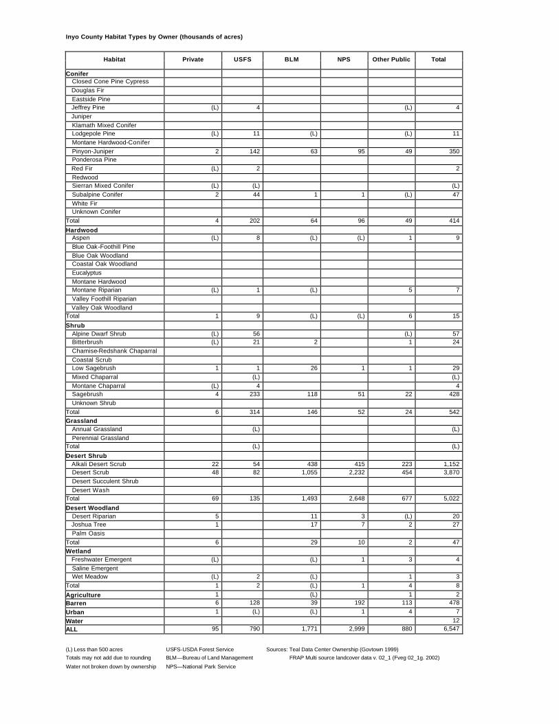
Inyo County Habitat Types by Owner (thousands of acres)
Habitat Private USFS BLM NPS Other Public Total
Conifer Closed Cone Pine Cypress Douglas Fir Eastside Pine Jeffrey Pine (L) 4 (L) 4 Juniper Klamath Mixed Conifer Lodgepole Pine (L) 11 (L) (L) 11 Montane Hardwood-Conifer Pinyon-Juniper 2 142 63 95 49 350 Ponderosa Pine Red Fir (L) 2 2 Redwood Sierran Mixed Conifer (L) (L) (L) Subalpine Conifer 2 44 1 1 (L) 47 White Fir Unknown Conifer Total 4 202 64 96 49 414
Hardwood Aspen (L) 8 (L) (L) 1 9 Blue Oak-Foothill Pine Blue Oak Woodland Coastal Oak Woodland Eucalyptus Montane Hardwood Montane Riparian (L) 1 (L) 5 7 Valley Foothill Riparian Valley Oak Woodland Total 1 9 (L) (L) 6 15
(L) Less than 500 acres USFS-USDA Forest Service Sources: Teal Data Center Ownership (Govtown 1999) Totals may not add due to rounding BLM—Bureau of Land Management FRAP Multi source landcover data v. 02_1 (Fveg 02_1g. 2002)
Water not broken down by ownership NPS—National Park Service
Kern County Habitat Types by Owner (thousands of acres)
Habitat Private USFS BLM NPS Other Public Total
Conifer Closed Cone Pine Cypress Douglas Fir Eastside Pine Jeffrey Pine 18 53 6 77 Juniper 9 (L) 2 (L) 11 Klamath Mixed Conifer Lodgepole Pine (L) (L) Montane Hardwood-Conifer 1 5 6 Pinyon-Juniper 45 86 28 1 161 Ponderosa Pine 2 11 5 18 Red Fir 1 1 Redwood Sierran Mixed Conifer 3 42 (L) 45 Subalpine Conifer (L) (L) White Fir 1 (L) 1 Unknown Conifer 6 (L) (L) 6 Total 86 197 41 2 325
Hardwood Aspen Blue Oak-Foothill Pine 38 7 9 (L) 53 Blue Oak Woodland 196 27 24 2 248 Coastal Oak Woodland 5 (L) (L) (L) 5 Eucalyptus Montane Hardwood 26 30 5 (L) 61 Montane Riparian 1 (L) (L) (L) 2 Valley Foothill Riparian 1 (L) (L) (L) 1 Valley Oak Woodland 32 1 33 Total 298 64 38 2 403
(L) Less than 500 acres USFS-USDA Forest Service Sources: Teal Data Center Ownership (Govtown 1999) Totals may not add due to rounding BLM—Bureau of Land Management FRAP Multi source landcover data v. 02_1 (Fveg 02_1g. 2002)
Water not broken down by ownership NPS—National Park Service
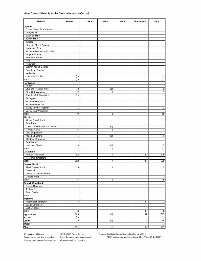
Kings County Habitat Types by Owner (thousands of acres)
Habitat Private USFS BLM NPS Other Public Total
Conifer Closed Cone Pine Cypress Douglas Fir Eastside Pine Jeffrey Pine Juniper Klamath Mixed Conifer Lodgepole Pine Montane Hardwood-Conifer Pinyon-Juniper Ponderosa Pine Red Fir Redwood Sierran Mixed Conifer Subalpine Conifer White Fir Unknown Conifer (L) (L) Total (L) (L)
Hardwood Aspen Blue Oak-Foothill Pine 2 (L) 2 Blue Oak Woodland 7 1 7 Coastal Oak Woodland (L) (L) Eucalyptus Montane Hardwood Montane Riparian Valley Foothill Riparian 1 1 Valley Oak Woodland Total 9 1 10
Desert Woodland Desert Riparian Joshua Tree Palm Oasis Total Wetland Freshwater Emergent 3 (L) 3 Saline Emergent Wet Meadow Total 3 (L) 3
Agriculture 603 (L) 12 615 Barren (L) (L)
Urban 29 (L) 4 34
Water 2 ALL 861 10 17 890
(L) Less than 500 acres USFS-USDA Forest Service Sources: Teal Data Center Ownership (Govtown 1999) Totals may not add due to rounding BLM—Bureau of Land Management FRAP Multi source landcover data v. 02_1 (Fveg 02_1g. 2002)
Water not broken down by ownership NPS—National Park Service
Lake County Habitat Types by Owner (thousands of acres)
Habitat Private USFS BLM NPS Other Public Total
Conifer Closed Cone Pine Cypress 10 19 6 (L) 35 Douglas Fir 22 61 2 1 86 Eastside Pine Jeffrey Pine (L) (L) Juniper Klamath Mixed Conifer 3 12 (L) 1 16 Lodgepole Pine Montane Hardwood-Conifer 21 16 2 1 40 Pinyon-Juniper Ponderosa Pine 4 14 (L) 1 19 Red Fir (L) 1 1 Redwood Sierran Mixed Conifer Subalpine Conifer White Fir (L) 3 3 Unknown Conifer Total 60 126 10 4 200
Hardwood Aspen Blue Oak-Foothill Pine 12 3 4 1 19 Blue Oak Woodland 47 1 6 1 55 Coastal Oak Woodland 1 1 (L) 1 Eucalyptus Montane Hardwood 62 46 7 1 116 Montane Riparian (L) (L) (L) (L) Valley Foothill Riparian Valley Oak Woodland 2 (L) 2 Total 123 50 17 3 193
Desert Woodland Desert Riparian Joshua Tree Palm Oasis Total Wetland Freshwater Emergent 1 (L) 1 Saline Emergent Wet Meadow (L) (L) (L) Total 1 (L) (L) 1
Agriculture 42 (L) (L) 42 Barren 1 (L) (L) (L) 2
Urban 19 (L) (L) 1 20
Water 49 ALL 412 254 123 13 852
(L) Less than 500 acres USFS-USDA Forest Service Sources: Teal Data Center Ownership (Govtown 1999) Totals may not add due to rounding BLM—Bureau of Land Management FRAP Multi source landcover data v. 02_1 (Fveg 02_1g. 2002)
Water not broken down by ownership NPS—National Park Service
Lassen County Habitat Types by Owner (thousands of acres)
Habitat Private USFS BLM NPS Other Public Total
Conifer Closed Cone Pine Cypress Douglas Fir Eastside Pine 169 217 29 1 417 Jeffrey Pine (L) 2 2 Juniper 50 16 132 2 199 Klamath Mixed Conifer Lodgepole Pine 4 24 (L) 1 (L) 29 Montane Hardwood-Conifer (L) 2 (L) 2 Pinyon-Juniper Ponderosa Pine 1 1 2 Red Fir 2 27 (L) 9 (L) 39 Redwood Sierran Mixed Conifer 166 158 13 6 (L) 343 Subalpine Conifer (L) (L) (L) White Fir 4 10 1 1 (L) 15 Unknown Conifer Total 396 457 175 17 4 1,049
Hardwood Aspen (L) 1 1 (L) 3 Blue Oak-Foothill Pine Blue Oak Woodland Coastal Oak Woodland Eucalyptus Montane Hardwood 3 3 1 7 Montane Riparian 4 (L) (L) 2 6 Valley Foothill Riparian Valley Oak Woodland Total 8 5 2 (L) 2 16
Desert Woodland Desert Riparian Joshua Tree Palm Oasis Total Wetland Freshwater Emergent Saline Emergent Wet Meadow 49 9 8 (L) 4 70 Total 49 9 8 (L) 4 70
Agriculture 121 (L) 1 6 128 Barren 4 2 7 2 1 17
Urban 4 (L) 6 10
Water 113 ALL 1,121 621 1,026 20 109 3,010
(L) Less than 500 acres USFS-USDA Forest Service Sources: Teal Data Center Ownership (Govtown 1999) Totals may not add due to rounding BLM—Bureau of Land Management FRAP Multi source landcover data v. 02_1 (Fveg 02_1g. 2002)
Water not broken down by ownership NPS—National Park Service
Los Angeles County Habitat Types by Owner (thousands of acres)
Habitat Private USFS BLM NPS Other Public Total
Conifer Closed Cone Pine Cypress (L) (L) Douglas Fir Eastside Pine (L) 6 6 Jeffrey Pine (L) 14 14 Juniper 32 4 1 (L) 37 Klamath Mixed Conifer Lodgepole Pine Montane Hardwood-Conifer 2 45 (L) (L) 47 Pinyon-Juniper 5 13 (L) (L) 19 Ponderosa Pine (L) (L) Red Fir Redwood Sierran Mixed Conifer 1 24 (L) 25 Subalpine Conifer (L) (L) White Fir (L) (L) Unknown Conifer Total 40 106 1 (L) 148
Hardwood Aspen Blue Oak-Foothill Pine (L) (L) (L) (L) Blue Oak Woodland 2 (L) 2 Coastal Oak Woodland 24 7 (L) 1 2 34 Eucalyptus 1 (L) 1 Montane Hardwood 8 55 (L) (L) 63 Montane Riparian 4 3 (L) (L) 1 8 Valley Foothill Riparian 2 (L) (L) 2 Valley Oak Woodland 2 (L) (L) (L) 2 Total 42 66 (L) 1 3 112
(L) Less than 500 acres USFS-USDA Forest Service Sources: Teal Data Center Ownership (Govtown 1999) Totals may not add due to rounding BLM—Bureau of Land Management FRAP Multi source landcover data v. 02_1 (Fveg 02_1g. 2002)
Water not broken down by ownership NPS—National Park Service
Madera County Habitat Types by Owner (thousands of acres)
Habitat Private USFS BLM NPS Other Public Total
Conifer Clos ed Cone Pine Cypress Douglas Fir Eastside Pine Jeffrey Pine (L) 2 2 Juniper 1 1 Klamath Mixed Conifer Lodgepole Pine (L) 3 27 30 Montane Hardwood-Conifer 6 26 (L) (L) (L) 33 Pinyon-Juniper Ponderosa Pine 4 34 (L) (L) (L) 38 Red Fir 1 81 7 89 Redwood Sierran Mixed Conifer 4 109 3 116 Subalpine Conifer (L) 29 9 38 White Fir (L) (L) Unknown Conifer 2 (L) (L) (L) (L) 2 Total 18 283 (L) 48 (L) 348
Hardwood Aspen (L) (L) Blue Oak-Foothill Pine 60 1 3 (L) 1 64 Blue Oak Woodland 64 7 (L) 1 (L) 72 Coastal Oak Woodland Eucalyptus Montane Hardwood 49 35 1 (L) (L) 86 Montane Riparian 1 (L) 1 Valley Foothill Riparian (L) (L) Valley Oak Woodland Total 174 43 4 2 1 224
(L) Less than 500 acres USFS-USDA Forest Service Sources: Teal Data Center Ownership (Govtown 1999)
Totals may not add due to rounding BLM—Bureau of Land Management FRAP Multi source landcover data v. 02_1 (Fveg 02_1g. 2002) Water not broken down by ownership NPS—National Park Service
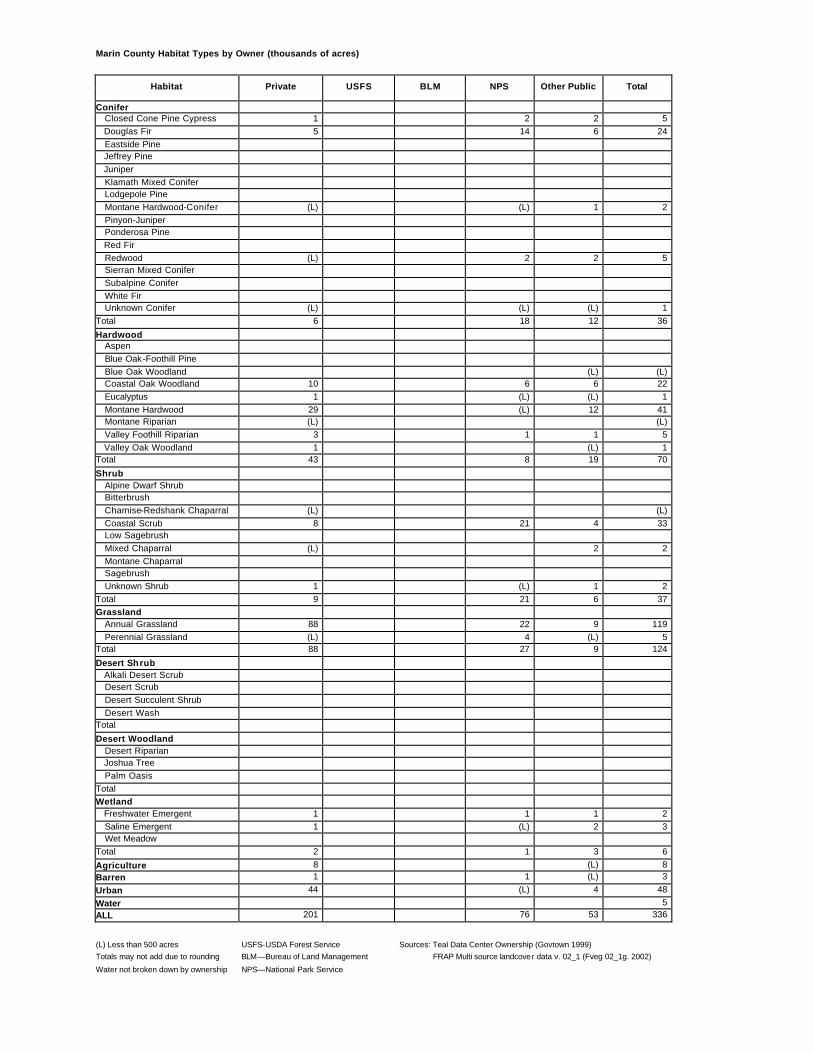
Marin County Habitat Types by Owner (thousands of acres)
Habitat Private USFS BLM NPS Other Public Total
Conifer Closed Cone Pine Cypress 1 2 2 5 Douglas Fir 5 14 6 24 Eastside Pine Jeffrey Pine Juniper Klamath Mixed Conifer Lodgepole Pine Montane Hardwood-Conifer (L) (L) 1 2 Pinyon-Juniper Ponderosa Pine Red Fir Redwood (L) 2 2 5 Sierran Mixed Conifer Subalpine Conifer White Fir Unknown Conifer (L) (L) (L) 1 Total 6 18 12 36
Hardwood Aspen Blue Oak-Foothill Pine Blue Oak Woodland (L) (L) Coastal Oak Woodland 10 6 6 22 Eucalyptus 1 (L) (L) 1 Montane Hardwood 29 (L) 12 41 Montane Riparian (L) (L) Valley Foothill Riparian 3 1 1 5 Valley Oak Woodland 1 (L) 1 Total 43 8 19 70
Desert Woodland Desert Riparian Joshua Tree Palm Oasis Total Wetland Freshwater Emergent 1 1 1 2 Saline Emergent 1 (L) 2 3 Wet Meadow Total 2 1 3 6
Agriculture 8 (L) 8 Barren 1 1 (L) 3
Urban 44 (L) 4 48
Water 5 ALL 201 76 53 336
(L) Less than 500 acres USFS-USDA Forest Service Sources: Teal Data Center Ownership (Govtown 1999) Totals may not add due to rounding BLM—Bureau of Land Management FRAP Multi source landcover data v. 02_1 (Fveg 02_1g. 2002)
Water not broken down by ownership NPS—National Park Service
Mariposa County Habitat Types by Owner (thousands of acres)
Habitat Private USFS BLM NPS Other Public Total
Conifer Closed Cone Pine Cypress (L) (L) (L) 1 Douglas Fir (L) 1 (L) (L) 1 Eastside Pine Jeffrey Pine 35 35 Juniper 1 1 Klamath Mixed Conifer Lodgepole Pine 44 44 Montane Hardwood-Conifer 16 13 1 4 34 Pinyon-Juniper Ponderosa Pine 15 33 2 21 (L) 71 Red Fir 47 47 Redwood Sierran Mixed Conifer 5 26 (L) 20 50 Subalpine Conifer 15 15 White Fir 15 15 Unknown Conifer 5 (L) 3 (L) 8 Total 40 73 6 201 (L) 321
Hardwood Aspen 1 1 Blue Oak-Foothill Pine 32 (L) 7 (L) (L) 40 Blue Oak Woodland 84 2 8 (L) (L) 94 Coastal Oak Woodland Eucalyptus Montane Hardwood 78 40 10 6 (L) 133 Montane Riparian 3 3 Valley Foothill Riparian Valley Oak Woodland (L) (L) Total 194 42 25 10 (L) 270
Desert Woodland Desert Riparian Joshua Tree Palm Oasis Total Wetland Freshwater Emergent Saline Emergent Wet Meadow 1 (L) 2 3 Total 1 (L) 2 3 Agriculture (L) (L) (L)
Barren (L) (L) (L) 20 20 Urban 3 (L) (L) 1 (L) 4
Water 7 ALL 444 171 70 242 (L) 935
(L) Less than 500 acres USFS-USDA Forest Service Sources: Teal Data Center Ownership (Govtown 1999)
Totals may not add due to rounding BLM—Bureau of Land Management FRAP Multi source landcover data v. 02_1 (Fveg 02_1g. 2002) Water not broken down by ownership NPS—National Park Service
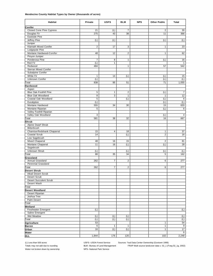
Mendocino County Habitat Types by Owner (thousands of acres)
Habitat Private USFS BLM NPS Other Public Total
Conifer Closed Cone Pine Cypress 21 (L) 7 2 30 Douglas Fir 275 43 38 11 366 Eastside Pine Jeffrey Pine (L) (L) (L) (L) Juniper Klamath Mixed Conifer 2 17 3 1 23 Lodgepole Pine Montane Hardwood-Conifer 48 12 2 1 62 Pinyon-Juniper Ponderosa Pine 7 8 1 (L) 16 Red Fir (L) 1 1 Redwood 484 1 57 542 Sierran Mixed Conifer Subalpine Conifer White Fir 1 14 (L) (L) 15 Unknown Conifer (L) (L) (L) Total 838 95 51 71 1,055 Hardwood Aspen Blue Oak-Foothill Pine 5 1 2 (L) 7 Blue Oak Woodland 8 3 1 1 12 Coastal Oak Woodland 5 (L) (L) 6 Eucalyptus (L) (L) (L) Montane Hardwood 555 34 30 15 633 Montane Riparian 5 (L) 6 Valley Foothill Riparian Valley Oak Woodland 3 (L) 4 Total 581 38 32 16 667 Shrub Alpine Dwarf Shrub Bitterbrush Chamise-Redshank Chaparral 15 4 18 1 37 Coastal Scrub 14 (L) 2 16 Low Sagebrush Mixed Chaparral 48 16 15 2 81 Montane Chaparral 11 16 (L) (L) 28 Sagebrush Unknown Shrub (L) (L) (L) (L) Total 88 35 34 5 162
Grassland Annual Grassland 262 7 2 6 277 Perennial Grassland Total 262 7 2 6 277 Desert Shrub Alkali Desert Scrub Desert Scrub Desert Succulent Scrub Desert Wash Total Desert Woodland Desert Riparian Joshua Tree Palm Desert Total
(L) Less than 500 acres USFS--USDA Forest Service Sources: Teal Data Center Ownership (Govtown 1999) Totals may not add due to rounding BLM--Bureau of Land Management FRAP Multi source landcover data v. 02_1 (Fveg 02_1g, 2002)
Water not broken down by ownership NPS--National Park Service
Merced County Habitat Types by Owner (thousands of acres)
Habitat Private USFS BLM NPS Other Public Total
Conifer Closed Cone Pine Cypress Douglas Fir Eastside Pine Jeffrey Pine Juniper Klamath Mixed Conifer Lodgepole Pine Montane Hardwood-Conifer Pinyon-Juniper Ponderosa Pine Red Fir Redwood Sierran Mixed Conifer Subalpine Conifer White Fir Unknown Conifer 1 (L) 1 Total 1 (L) 1 Hardwood Aspen Blue Oak-Foothill Pine 16 (L) (L) 17 Blue Oak Woodland 42 (L) 2 44 Coastal Oak Woodland 3 (L) 4 Eucalyptus Montane Hardwood 2 (L) 2 Montane Riparian Valley Foothill Riparian 4 1 5 Valley Oak Woodland (L) (L) Total 67 1 3 71 Shrub Alpine Dwarf Shrub Bitterbrush Chamise-Redshank Chaparral (L) (L) Coastal Scrub 1 (L) (L) 1 Low Sagebrush Mixed Chaparral 1 (L) 1 Montane Chaparral Sagebrush Unknown Shrub 6 (L) (L) 6 Total 8 (L) (L) 8
(L) Less than 500 acres USFS-USDA Forest Service Sources: Teal Data Center Ownership (Govtown 1999) Totals may not add due to rounding BLM—Bureau of Land Management FRAP Multi source landcover data v. 02_1 (Fveg 02_1g. 2002)
Water not broken down by ownership NPS—National Park Service
Modoc County Habitat Types by Owner (thousands of acres)
Habitat Private USFS BLM NPS Other Public Total
Conifer Closed Cone Pine Cypress Douglas Fir Eastside Pine 132 281 3 1 417 Jeffrey Pine Juniper 86 264 42 8 400 Klamath Mixed Conifer Lodgepole Pine (L) 9 10 Montane Hardwood-Conifer Pinyon-Juniper Ponderosa Pine Red Fir Redwood Sierran Mixed Conifer 52 84 1 1 138 Subalpine Conifer 5 5 White Fir 3 39 (L) 43 Unknown Conifer Total 274 682 46 11 1,011
Hardwood Aspen (L) 4 (L) (L) 5 Blue Oak-Foothill Pine Blue Oak Woodland Coastal Oak Woodland Eucalyptus Montane Hardwood (L) 1 (L) 1 Montane Riparian 1 (L) (L) 1 2 Valley Foothill Riparian Valley Oak Woodland Total 2 5 (L) 1 8
(L) Less than 500 acres USFS-USDA Forest Service Sources: Teal Data Center Ownership (Govtown 1999)
Totals may not add due to rounding BLM—Bureau of Land Management FRAP Multi source landcover data v. 02_1 (Fveg 02_1g. 2002) Water not broken down by ownership NPS—National Park Service
Mono County Habitat Types by Owner (thousands of acres)
Habitat Private USFS BLM NPS Other Public Total
Conifer Closed Cone Pine Cypress Douglas Fir Eastside Pine Jeffrey Pine 2 100 1 2 105 Juniper 1 (L) 3 4 Klamath Mixed Conifer Lodgepole Pine 1 49 (L) (L) 50 Montane Hardwood-Conifer Pinyon-Juniper 12 150 60 5 227 Ponderosa Pine Red Fir (L) 10 (L) 11 Redwood Sierran Mixed Conifer 5 32 4 4 45 Subalpine Conifer 4 42 1 1 47 White Fir (L) (L) (L) Unknown Conifer Total 25 383 69 11 489
Hardwood Aspen 2 15 (L) 1 18 Blue Oak-Foothill Pine Blue Oak Woodland Coastal Oak Woodland Eucalyptus Montane Hardwood Montane Riparian 2 (L) (L) 3 5 Valley Foothill Riparian Valley Oak Woodland Total 4 15 (L) 4 23
(L) Less than 500 acres USFS-USDA Forest Service Sources: Teal Data Center Ownership (Govtown 1999)
Totals may not add due to rounding BLM—Bureau of Land Management FRAP Multi source landcover data v. 02_1 (Fveg 02_1g. 2002) Water not broken down by ownership NPS—National Park Service
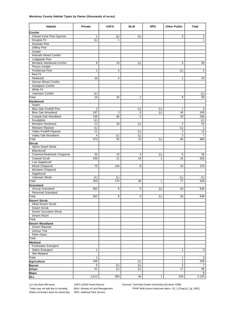
Monterey County Habitat Types by Owner (thousands of acres)
Habitat Private USFS BLM NPS Other Public Total
Conifer Closed Cone Pine Cypress 1 (L) (L) 2 4 Douglas Fir (L) 1 1 Eastside Pine Jeffrey Pine Juniper Klamath Mixed Conifer Lodgepole Pine Montane Hardwood-Conifer 8 23 (L) 5 35 Pinyon-Juniper Ponderosa Pine 1 3 (L) 4 Red Fir Redwood 10 4 1 15 Sierran Mixed Conifer Subalpine Conifer White Fir Unknown Conifer (L) (L) Total 19 32 1 8 59
Hardwood Aspen Blue Oak-Foothill Pine 2 (L) (L) 1 3 Blue Oak Woodland 197 3 5 (L) 45 249 Coastal Oak Woodland 149 60 5 33 246 Eucalyptus (L) (L) Montane Hardwood 11 29 (L) 2 42 Montane Riparian (L) (L) 1 Valley Foothill Riparian 11 (L) 2 13 Valley Oak Woodland 4 (L) (L) 2 7 Total 373 92 10 (L) 84 560
(L) Less than 500 acres USFS-USDA Forest Service Sources: Teal Data Center Ownership (Govtown 1999)
Totals may not add due to rounding BLM—Bureau of Land Management FRAP Multi source landcover data v. 02_1 (Fveg 02_1g. 2002) Water not broken down by ownership NPS—National Park Service
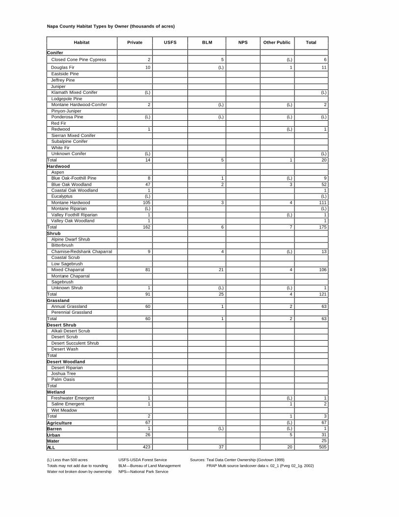
Napa County Habitat Types by Owner (thousands of acres)
Habitat Private USFS BLM NPS Other Public Total
Conifer
Closed Cone Pine Cypress 2 5 (L) 6
Douglas Fir 10 (L) 1 11 Eastside Pine Jeffrey Pine Juniper Klamath Mixed Conifer (L) (L) Lodgepole Pine Montane Hardwood-Conifer 2 (L) (L) 2 Pinyon-Juniper Ponderosa Pine (L) (L) (L) (L) Red Fir Redwood 1 (L) 1 Sierran Mixed Conifer Subalpine Conifer White Fir Unknown Conifer (L) (L) Total 14 5 1 20 Hardwood Aspen Blue Oak-Foothill Pine 8 1 (L) 9 Blue Oak Woodland 47 2 3 52 Coastal Oak Woodland 1 1 Eucalyptus (L) (L) Montane Hardwood 105 3 4 111 Montane Riparian (L) (L) Valley Foothill Riparian 1 (L) 1 Valley Oak Woodland 1 1 Total 162 6 7 175 Shrub Alpine Dwarf Shrub Bitterbrush Chamise-Redshank Chaparral 9 4 (L) 13 Coastal Scrub Low Sagebrush Mixed Chaparral 81 21 4 106 Montane Chaparral Sagebrush Unknown Shrub 1 (L) (L) 1 Total 91 25 4 121 Grassland Annual Grassland 60 1 2 63 Perennial Grassland Total 60 1 2 63 Desert Shrub Alkali Desert Scrub Desert Scrub Desert Succulent Shrub Desert Wash Total Desert Woodland Desert Riparian Joshua Tree Palm Oasis Total Wetland Freshwater Emergent 1 (L) 1 Saline Emergent 1 1 2 Wet Meadow Total 2 1 3
Agriculture 67 (L) 67 Barren 1 (L) (L) 1
Urban 26 5 31 Water 25
ALL 423 37 20 505
(L) Less than 500 acres USFS-USDA Forest Service Sources: Teal Data Center Ownership (Govtown 1999) Totals may not add due to rounding BLM—Bureau of Land Management FRAP Multi source landcover data v. 02_1 (Fveg 02_1g. 2002) Water not broken down by ownership NPS—National Park Service
Nevada County Habitat Types by Owner (thousands of acres)
Habitat Private USFS BLM NPS Other Public Total
Conifer Closed Cone Pine Cypress (L) (L) (L) Douglas Fir 28 12 4 1 45 Eastside Pine 11 16 (L) 28 Jeffrey Pine 1 1 1 Juniper (L) (L) Klamath Mixed Conifer Lodgepole Pine 3 1 (L) 5 Montane Hardwood-Conifer 25 3 1 (L) 29 Pinyon-Juniper Ponderosa Pine 35 2 5 1 42 Red Fir 20 18 (L) 38 Redwood Sierran Mixed Conifer 73 70 1 1 145 Subalpine Conifer 1 2 3 White Fir 5 5 11 Unknown Conifer (L) (L) Total 202 130 11 3 347 Hardwood Aspen (L) (L) Blue Oak-Foothill Pine 4 (L) (L) (L) 4 Blue Oak Woodland 28 (L) 2 30 Coastal Oak Woodland (L) (L) (L) Eucalyptus Montane Hardwood 78 5 4 1 89 Montane Riparian 1 1 (L) (L) 2 Valley Foothill Riparian Valley Oak Woodland 2 (L) (L) 2 Total 112 6 5 4 127 Shrub Alpine Dwarf Shrub Bitterbrush 1 (L) (L) 1 Chamise-Redshank Chaparral Coastal Scrub Low Sagebrush Mixed Chaparral 7 (L) 1 (L) 9 Montane Chaparral 14 14 (L) (L) 29 Sagebrush 5 6 (L) 11 Unknown Shrub Total 28 20 1 1 50
Grassland Annual Grassland 28 1 (L) 1 31 Perennial Grassland Total 28 1 (L) 1 31 Desert Shrub Alkali Desert Scrub Desert Scrub Desert Succulent Shrub Desert Wash Total Desert Woodland Desert Riparian Joshua Tree Palm Oasis Total
(L) Less than 500 acres USFS-USDA Forest Service Sources: Teal Data Center Ownership (Govtown 1999) Totals may not add due to rounding BLM—Bureau of Land Management FRAP Multi source landcover data v. 02_1 (Fveg 02_1g. 2002)
Water not broken down by ownership NPS—National Park Service
Orange County Habitat Types by Owner (thousands of acres)
Habitat Private USFS BLM NPS Other Public Total
Conifer Closed Cone Pine Cypress (L) (L) (L) (L) Douglas Fir Eastside Pine Jeffrey Pine Juniper Klamath Mixed Conifer Lodgepole Pine Montane Hardwood-Conifer (L) 1 1 Pinyon-Juniper Ponderosa Pine Red Fir Redwood Sierran Mixed Conifer Subalpine Conifer White Fir Unknown Conifer Total (L) 1 (L) 1
Hardwood Aspen Blue Oak-Foothill Pine Blue Oak Woodland Coastal Oak Woodland 7 2 1 10 Eucalyptus (L) (L) Montane Hardwood (L) 2 2 Montane Riparian (L) (L) Valley Foothill Riparian 2 (L) 1 3 Valley Oak Woodland Total 9 5 2 16
(L) Less than 500 acres USFS-USDA Forest Service Sources: Teal Data Center Ownership (Govtown 1999)
Totals may not add due to rounding BLM—Bureau of Land Management FRAP Multi source landcover data v. 02_1 (Fveg 02_1g. 2002) Water not broken down by ownership NPS—National Park Service
Placer County Habitat Types by Owner (thousands of acres)
Habitat Private USFS BLM NPS Other Public Total
Conifer Closed Cone Pine Cypress (L) 1 (L) (L) 1 Douglas Fir 24 18 5 1 48 Eastside Pine 3 1 4 Jeffrey Pine 2 3 (L) 5 Juniper (L) (L) Klamath Mixed Conifer Lodgepole Pine 3 4 (L) 7 Montane Hardwood-Conifer 29 22 4 5 60 Pinyon-Juniper Ponderosa Pine 16 13 4 1 34 Red Fir 19 30 (L) 48 Redwood Sierran Mixed Conifer 68 133 (L) 2 202 Subalpine Conifer 1 (L) 1 White Fir 16 19 (L) 35 Unknown Conifer (L) (L) Total 181 241 13 9 445 Hardwood Aspen (L) (L) (L) Blue Oak-Foothill Pine 2 (L) (L) (L) 3 Blue Oak Woodland 62 (L) (L) 62 Coastal Oak Woodland Eucalyptus Montane Hardwood 47 27 8 9 91 Montane Riparian 1 2 (L) 3 Valley Foothill Riparian 1 1 Valley Oak Woodland (L) (L) Total 112 29 9 10 160 Shrub Alpine Dwarf Shrub (L) 1 1 Bitterbrush (L) (L) Chamise-Redshank Chaparral Coastal Scrub Low Sagebrush Mixed Chaparral 5 3 1 3 12 Montane Chaparral 20 33 (L) 53 Sagebrush 1 (L) 1 Unknown Shrub (L) (L) (L) Total 27 37 1 3 68
Grassland Annual Grassland 100 (L) (L) 1 102 Perennial Grassland Total 100 (L) (L) 1 102 Desert Shrub Alkali Desert Scrub Desert Scrub Desert Succulent Shrub Desert Wash Total Desert Woodland Desert Riparian Joshua Tree Palm Oasis Total
(L) Less than 500 acres USFS-USDA Forest Service Sources: Teal Data Center Ownership (Govtown 1999) Totals may not add due to rounding BLM—Bureau of Land Management FRAP Multi source landcover data v. 02_1 (Fveg 02_1g. 2002)
Water not broken down by ownership NPS—National Park Service
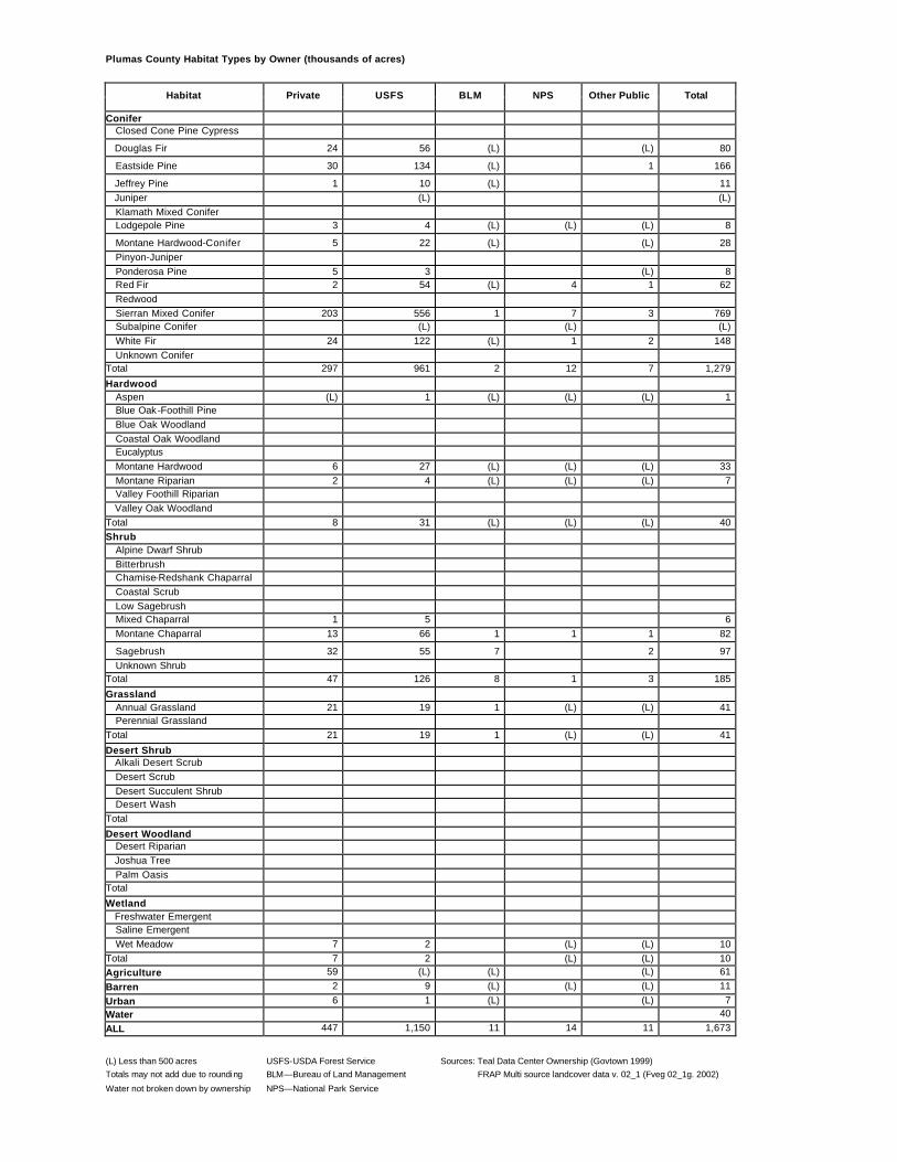
Plumas County Habitat Types by Owner (thousands of acres)
Habitat Private USFS BLM NPS Other Public Total
Conifer Closed Cone Pine Cypress
Douglas Fir 24 56 (L) (L) 80
Eastside Pine 30 134 (L) 1 166
Jeffrey Pine 1 10 (L) 11 Juniper (L) (L) Klamath Mixed Conifer Lodgepole Pine 3 4 (L) (L) (L) 8
Montane Hardwood-Conifer 5 22 (L) (L) 28 Pinyon-Juniper Ponderosa Pine 5 3 (L) 8 Red Fir 2 54 (L) 4 1 62 Redwood Sierran Mixed Conifer 203 556 1 7 3 769 Subalpine Conifer (L) (L) (L) White Fir 24 122 (L) 1 2 148 Unknown Conifer Total 297 961 2 12 7 1,279
Hardwood Aspen (L) 1 (L) (L) (L) 1 Blue Oak-Foothill Pine Blue Oak Woodland Coastal Oak Woodland Eucalyptus Montane Hardwood 6 27 (L) (L) (L) 33 Montane Riparian 2 4 (L) (L) (L) 7 Valley Foothill Riparian Valley Oak Woodland Total 8 31 (L) (L) (L) 40 Shrub Alpine Dwarf Shrub Bitterbrush Chamise-Redshank Chaparral Coastal Scrub Low Sagebrush Mixed Chaparral 1 5 6 Montane Chaparral 13 66 1 1 1 82
(L) Less than 500 acres USFS-USDA Forest Service Sources: Teal Data Center Ownership (Govtown 1999) Totals may not add due to rounding BLM—Bureau of Land Management FRAP Multi source landcover data v. 02_1 (Fveg 02_1g. 2002)
Water not broken down by ownership NPS—National Park Service
Riverside County Habitat Types by Owner (thousands of acres)
Habitat Private USFS BLM NPS Other Public Total
Conifer Closed Cone Pine Cypress (L) (L) Douglas Fir Eastside Pine (L) (L) Jeffrey Pine 1 2 (L) (L) 3 Juniper 3 (L) 1 21 8 34 Klamath Mixed Conif er Lodgepole Pine (L) (L) Montane Hardwood-Conifer 4 15 (L) 2 21 Pinyon-Juniper 3 10 9 10 5 37 Ponderosa Pine (L) (L) Red Fir Redwood Sierran Mixed Conifer 4 17 (L) 7 28 Subalpine Conifer (L) 2 2 White Fir (L) (L) (L) Unknown Conifer Total 16 43 11 31 25 125 Hardwood Aspen Blue Oak-Foothill Pine Blue Oak Woodland Coastal Oak Woodland 10 3 (L) 1 14 Eucalyptus (L) (L) (L) Montane Hardwood 2 15 (L) 2 19 Montane Riparian 1 (L) (L) 1 1 Valley Foothill Riparian 8 1 (L) 3 11 Valley Oak Woodland Total 19 19 1 (L) 7 46 Shrub Alpine Dwarf Shrub Bitterbrush Chamise-Redshank Chaparral 92 77 19 29 218 Coastal Scrub 146 8 8 17 179 Low Sagebrush Mixed Chaparral 144 129 32 1 29 334 Montane Chaparral 1 3 (L) 1 4 Sagebrush 6 1 1 4 12 Unknown Shrub Total 388 218 60 1 80 747
(L) Less than 500 acres USFS-USDA Forest Service Sources: Teal Data Center Ownership (Govtown 1999) Totals may not add due to rounding BLM—Bureau of Land Management FRAP Multi source landcover data v. 02_1 (Fveg 02_1g. 2002)
Water not broken down by ownership NPS—National Park Service
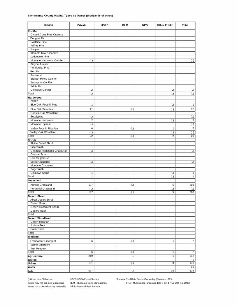
Sacramento County Habitat Types by Owner (thousands of acres)
Habitat Private USFS BLM NPS Other Public Total
Conifer Closed Cone Pine Cypress Douglas Fir Eastside Pine Jeffrey Pine Juniper Klamath Mixed Conifer Lodgepole Pine Montane Hardwood-Conifer (L) (L) Pinyon-Juniper Ponderosa Pine Red Fir Redwood Sierran Mixed Conifer Subalpine Conifer White Fir Unknown Conifer (L) (L) (L) Total (L) (L) (L)
Hardwood Aspen Blue Oak-Foothill Pine 1 (L) 1
Blue Oak Woodland 11 (L) (L) 12 Coastal Oak Woodland Eucalyptus (L) (L) Montane Hardwood 2 (L) 3 Montane Riparian (L) (L)
Valley Foothill Riparian 6 (L) 1 7 Valley Oak Woodland (L) (L) (L) Total 22 (L) 2 23
(L) Less than 500 acres USFS-USDA Forest Ser vice Sources: Teal Data Center Ownership (Govtown 1999)
Totals may not add due to rounding BLM—Bureau of Land Management FRAP Multi source landcover data v. 02_1 (Fveg 02_1g. 2002) Water not broken down by ownership NPS—National Park Service
San Benito County Habitat Types by Owner (thousands of acres)
Habitat Private USFS BLM NPS Other Public Total
Conifer Closed Cone Pine Cypress Douglas Fir Eastside Pine
Jeffrey Pine (L) (L) (L)
Juniper 1 (L) 1 Klamath Mixed Conifer Lodgepole Pine Montane Hardwood-Conifer (L) (L) Pinyon-Juniper Ponderosa Pine Red Fir Redwood
Sierran Mixed Conifer (L) (L) (L) Subalpine Conifer White Fir Unknown Conifer 3 (L) (L) (L) 3 Total 4 (L) (L) (L) 4
Hardwood Aspen Blue Oak-Foothill Pine 88 30 1 (L) 119 Blue Oak Woodland 83 4 3 (L) 89 Coastal Oak Woodland 33 (L) (L) 1 34 Eucalyptus 1 1 Montane Hardwood 1 (L) (L) (L) 2 Montane Riparian Valley Foothill Riparian (L) (L) Valley Oak Woodland 5 (L) 5 Total 211 34 4 1 250
Desert Woodland Desert Riparian Joshua Tree Palm Oasis Total Wetland Freshwater Emergent Saline Emergent Wet Meadow Total
Agriculture 53 53 Barren (L) (L) (L) 1
Urban 9 (L) (L) (L) 10
Water 1 ALL 779 91 14 4 889
(L) Less than 500 acres USFS-USDA Forest Service Sources: Teal Data Center Ownership (Govtown 1999) Totals may not add due to rounding BLM—Bureau of Land Management FRAP Multi source landcover data v. 02_1 (Fveg 02_1g. 2002)
Water not broken down by ownership NPS—National Park Service
San Bernadino County Habitat Types by Owner (thousands of acres)
Habitat Private USFS BLM NPS Other Public Total
Conifer Closed Cone Pine Cypress (L) 1 1 Douglas Fir Eastside Pine 7 29 1 (L) 36 Jeffrey Pine 1 12 13 Juniper 26 (L) 11 30 2 69 Klamath Mixed Conifer Lodgepole Pine (L) (L) (L) Montane Hardwood-Conifer 7 34 (L) (L) 42 Pinyon-Juniper 31 62 30 48 23 193 Ponderosa Pine (L) 1 (L) 1 Red Fir Redwood Sierran Mixed Conifer 12 68 (L) 80 Subalpine Conifer (L) 10 10 White Fir (L) (L) (L) Unknown Conifer Total 84 217 42 78 25 446 Hardwood Aspen Blue Oak-Foothill Pine Blue Oak Woodland Coastal Oak Woodland 2 (L) (L) 1 2 Eucalyptus (L) (L) (L) (L) Montane Hardwood 9 36 (L) (L) 46 Montane Riparian 1 1 (L) (L) (L) 1 Valley Foothill Riparian 2 1 (L) 1 4 Valley Oak Woodland Total 14 38 (L) (L) 2 53 Shrub Alpine Dwarf Shrub (L) (L) Bitterbrush Chamise-Redshank Chaparral 14 11 2 (L) 27 Coastal Scrub 33 6 1 1 41 Low Sagebrush Mixed Chaparral 65 152 24 (L) 3 244 Montane Chaparral 1 16 (L) 17 Sagebrush 21 5 28 100 8 162 Unknown Shrub Total 134 190 55 100 12 490
(L) Less than 500 acres USFS-USDA Forest Service Sources: Teal Data Center Ownership (Govtown 1999) Totals may not add due to rounding BLM—Bureau of Land Management FRAP Multi source landcover data v. 02_1 (Fveg 02_1g. 2002)
Water not broken down by ownership NPS—National Park Service
San Diego County Habitat Types by Owner (thousands of acres)
Habitat Private USFS BLM NPS Other Public Total
Conifer Closed Cone Pine Cypress (L) (L) 5 (L) 5 Douglas Fir Eastside Pine Jeffrey Pine 1 5 2 7 Juniper 2 1 34 37 Klamath Mixed Conifer Lodgepole Pine Montane Hardwood-Conifer 18 8 (L) 13 40 Pinyon-Juniper (L) (L) 8 8 Ponderosa Pine Red Fir Redwood Sierran Mixed Conifer (L) (L) 1 1 Subalpine Conifer White Fir 1 (L) (L) 1 Unknown Conifer Total 22 13 6 58 100 Hardwood Aspen Blue Oak-Foothill Pine Blue Oak Woodland Coastal Oak Woodland 61 13 1 15 90 Eucalyptus 2 (L) 2 Montane Hardwood 14 6 (L) 9 29 Montane Riparian (L) (L) Valley Foothill Riparian 12 1 (L) 8 20 Valley Oak Woodland Total 89 19 2 32 142 Shrub Alpine Dwarf Shrub Bitterbrush Chamise-Redshank Chaparral 75 79 25 40 219 Coastal Scrub 152 13 14 (L) 83 263 Low Sagebrush Mixed Chaparral 268 149 93 146 656 Montane Chaparral 3 7 1 4 15 Sagebrush 2 (L) (L) (L) 3 Unknown Shrub Total 500 248 134 (L) 274 1,155
(L) Less than 500 acres USFS-USDA Forest Service Sources: Teal Data Center Ownership (Govtown 1999) Totals may not add due to rounding BLM—Bureau of Land Management FRAP Multi source landcover data v. 02_1 (Fveg 02_1g. 2002)
Water not broken down by ownership NPS—National Park Service
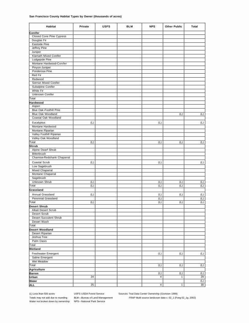
San Francisco County Habitat Types by Owner (thousands of acres)
Habitat Private USFS BLM NPS Other Public Total
Conifer Closed Cone Pine Cypress Douglas Fir Eastside Pine Jeffrey Pine Juniper Klamath Mixed Conifer Lodgepole Pine Montane Hardwood-Conifer Pinyon-Juniper Ponderosa Pine Red Fir Redwood Sierran Mixed Conifer Subalpine Conifer White Fir Unknown Conifer Total
Hardwood Aspen Blue Oak-Foothill Pine Blue Oak Woodland (L) (L) Coastal Oak Woodland
Eucalyptus (L) (L) (L) Montane Hardwood Montane Riparian Valley Foothill Riparian Valley Oak Woodland Total (L) (L) (L) (L) Shrub Alpine Dwarf Shrub Bitterbrush Chamise-Redshank Chaparral
(L) Less than 500 acres USFS-USDA Forest Service Sources: Teal Data Center Ownership (Govtown 1999)
Totals may not add due to rounding BLM—Bureau of Land Management FRAP Multi source landcover data v. 02_1 (Fveg 02_1g. 2002) Water not broken down by ownership NPS—National Park Service
San Joaquin County Habitat Types by Owner (thousands of acres)
Habitat Private USFS BLM NPS Other Public Total
Conifer Closed Cone Pine Cypress Douglas Fir Eastside Pine Jeffrey Pine Juniper Klamath Mixed Conifer Lodgepole Pine Montane Hardwood-Conifer (L) (L) Pinyon-Juniper Ponderosa Pine Red Fir Redwood Sierran Mixed Conifer Subalpine Conifer White Fir Unknown Conifer (L) (L) Total (L) (L)
Hardwood Aspen Blue Oak-Foothill Pine 12 12 Blue Oak Woodland 9 9 Coastal Oak Woodland Eucalyptus (L) (L) Montane Hardwood 2 2 Montane Riparian Valley Foothill Riparian 5 (L) 5 Valley Oak Woodland Total 28 (L) 29
(L) Less than 500 acres USFS-USDA Forest Service Sources: Teal Data Center Ownership (Govtown 1999) Totals may not add due to rounding BLM—Bureau of Land Management FRAP Multi source landcover data v. 02_1 (Fveg 02_1g. 2002)
Water not broken down by ownership NPS—National Park Service
San Luis Obispo County Habitat Types by Owner (thousands of acres)
Habitat Private USFS BLM NPS Other Public Total
Conifer Closed Cone Pine Cypress 1 2 (L) (L) 3 Douglas Fir Eastside Pine Jeffrey Pine Juniper 2 4 (L) 6 Klamath Mixed Conifer Lodgepole Pine Montane Hardwood-Conifer 12 1 (L) (L) 13 Pinyon-Juniper (L) (L) Ponderosa Pine 1 (L) (L) 1 Red Fir Redwood Sierran Mixed Conifer Subalpine Conifer White Fir Unknown Conifer 1 (L) (L) 1 Total 16 3 4 (L) 23
Hardwood Aspen Blue Oak-Foothill Pine 35 (L) (L) 1 36 Blue Oak Woodland 141 19 17 10 187 Coastal Oak Woodland 163 19 3 3 188 Eucalyptus (L) (L) Montane Hardwood 28 (L) 1 (L) 28 Montane Riparian (L) (L) Valley Foothill Riparian 3 (L) 3 Valley Oak Woodland 11 (L) (L) 11 Total 380 39 21 15 454
(L) Less than 500 acres USFS-USDA Forest Service Sources: Teal Data Center Ownership (Govtown 1999)
Totals may not add due to rounding BLM—Bureau of Land Management FRAP Multi source landcover data v. 02_1 (Fveg 02_1g. 2002) Water not broken down by ownership NPS—National Park Service
San Mateo County Habitat Types by Owner (thousands of acres)
Habitat Private USFS BLM NPS Other Public Total
Conifer Closed Cone Pine Cypress 1 (L) (L) 1 Douglas Fir 5 (L) 1 6 Eastside Pine Jeffrey Pine Juniper Klamath Mixed Conifer Lodgepole Pine Montane Hardwood-Conifer 1 (L) (L) 1 Pinyon-Juniper Ponderosa Pine (L) (L) Red Fir Redwood 36 (L) (L) 12 49 Sierran Mixed Conifer Subalpine Conifer White Fir Unknown Conifer 8 (L) (L) 1 9 Total 52 (L) 1 14 66
Hardwood Aspen Blue Oak-Foothill Pine Blue Oak Woodland Coastal Oak Woodland 7 1 (L) 8
Desert Woodland Desert Riparian Joshua Tree Palm Oasis Total Wetland Freshwater Emergent 1 (L) (L) 1 Saline Emergent 1 1 2 Wet Meadow Total 1 (L) 1 2
Agriculture 6 1 7 Barren 1 (L) (L) 1
Urban 89 (L) 2 91
Water 4 (L) (L) 4 ALL 254 (L) 3 30 291
(L) Less than 500 acres USFS-USDA Forest Service Sources: Teal Data Center Ownership (Govtown 1999) Totals may not add due to rounding BLM—Bureau of Land Management FRAP Multi source landcover data v. 02_1 (Fveg 02_1g. 2002)
Water not broken down by ownership NPS—National Park Service
Santa Barbara County Habitat Types by Owner (thousands of acres)
Habitat Private USFS BLM NPS Other Public Total
Conifer Closed Cone Pine Cypress (L) 1 1 Douglas Fir Eastside Pine Jeffrey Pine (L) (L) Juniper 5 2 1 8 Klamath Mixed Conifer Lodgepole Pine Montane Hardwood-Conifer 1 21 (L) 22 Pinyon-Juniper 1 29 (L) 30 Ponderosa Pine Red Fir Redwood Sierran Mixed Conifer 2 2 Subalpine Conifer White Fir Unknown Conifer (L) (L) Total 7 55 1 1 64
Hardwood Aspen Blue Oak-Foothill Pine 1 1 2 Blue Oak Woodland 19 11 (L) 30 Coastal Oak Woodland 131 27 1 12 170 Eucalyptus 1 1 1 Montane Hardwood 1 26 (L) 28 Montane Riparian 7 3 3 12 Valley Foothill Riparian 1 1 (L) 2 Valley Oak Woodland 3 (L) (L) 3 Total 163 68 1 16 248
(L) Less than 500 acres USFS-USDA Forest Service Sources: Teal Data Center Ownership (Govtown 1999)
Totals may not add due to rounding BLM—Bureau of Land Management FRAP Multi source landcover data v. 02_1 (Fveg 02_1g. 2002) Water not broken down by ownership NPS—National Park Service
Santa Clara County Habitat Types by Owner (thousands of acres)
Habitat Private USFS BLM NPS Other Public Total
Conifer Closed Cone Pine Cypress Douglas Fir (L) (L) (L) Eastside Pine Jeffrey Pine Juniper Klamath Mixed Conifer Lodgepole Pine Montane Hardwood-Conifer 1 (L) 1 Pinyon-Juniper Ponderosa Pine (L) (L) (L) Red Fir Redwood 10 (L) 2 11 Sierran Mixed Conifer Subalpine Conifer White Fir Unknown Conifer 33 (L) 5 38 Total 44 (L) 7 51 Hardwood Aspen Blue Oak-Foothill Pine 40 (L) 7 47 Blue Oak Woodland 8 1 9 Coastal Oak Woodland 90 (L) 16 107 Eucalyptus Montane Hardwood 5 (L) 5 Montane Riparian Valley Foothill Riparian (L) (L) (L) Valley Oak Woodland 24 (L) 5 29 Total 168 (L) 29 197 Shrub Alpine Dwarf Shrub Bitterbrush Chamise-Redshank Chaparral 84 (L) 15 99 Coastal Scrub 9 (L) (L) 9 Low Sagebrush Mixed Chaparral 18 1 2 22 Montane Chaparral Sagebrush Unknown Shrub 37 (L) 7 44 Total 149 1 24 174
Grassland Annual Grassland 145 (L) 7 152 Perennial Grassland Total 145 (L) 7 152 Desert Shrub Alkali Desert Scrub Desert Scrub Desert Succulent Shrub Desert Wash Total Desert Woodland Desert Riparian Joshua Tree Palm Oasis Total
(L) Less than 500 acres USFS-USDA Forest Service Sources: Teal Data Center Ownership (Govtown 1999) Totals may not add due to rounding BLM—Bureau of Land Management FRAP Multi source landcover data v. 02_1 (Fveg 02_1g. 2002)
Water not broken down by ownership NPS—National Park Service
Santa Cruz County Habitat Types by Owner (thousands of acres)
Habitat Private USFS BLM NPS Other Public Total
Conifer Closed Cone Pine Cypress 1 1 2 Douglas Fir 1 (L) 2 Eastside Pine Jeffrey Pine Juniper Klamath Mixed Conifer Lodgepole Pine Montane Hardwood-Conifer Pinyon-Juniper Ponderosa Pine Red Fir Redwood 86 28 114 Sierran Mixed Conifer Subalpine Conifer White Fir Unknown Conifer 19 1 20 Total 107 31 138
Hardwood Aspen Blue Oak-Foothill Pine Blue Oak Woodland Coastal Oak Woodland 10 1 10 Eucalyptus Montane Hardwood 1 (L) 1 Montane Riparian Valley Foothill Riparian (L) (L) (L) Valley Oak Woodland Total 10 1 11
Desert Woodland Desert Riparian Joshua Tree Palm Oasis Total Wetland Freshwater Emergent Saline Emergent Wet Meadow Total
Agriculture 29 1 30 Barren (L) (L) (L)
Urban 35 1 36
Water 1 ALL 243 42 285
(L) Less than 500 acres USFS-USDA Forest Service Sources: Teal Data Center Ownership (Govtown 1999) Totals may not add due to rounding BLM—Bureau of Land Management FRAP Multi source landcover data v. 02_1 (Fveg 02_1g. 2002)
Water not broken down by ownership NPS—National Park Service
Shasta County Habitat Types by Owner (thousands of acres)
(L) Less than 500 acres USFS-USDA Forest Service Sources: Teal Data Center Ownership (Govtown 1999) Totals may not add due to rounding BLM—Bureau of Land Management FRAP Multi source landcover data v. 02_1 (Fveg 02_1g. 2002)
Water not broken down by ownership NPS—National Park Service
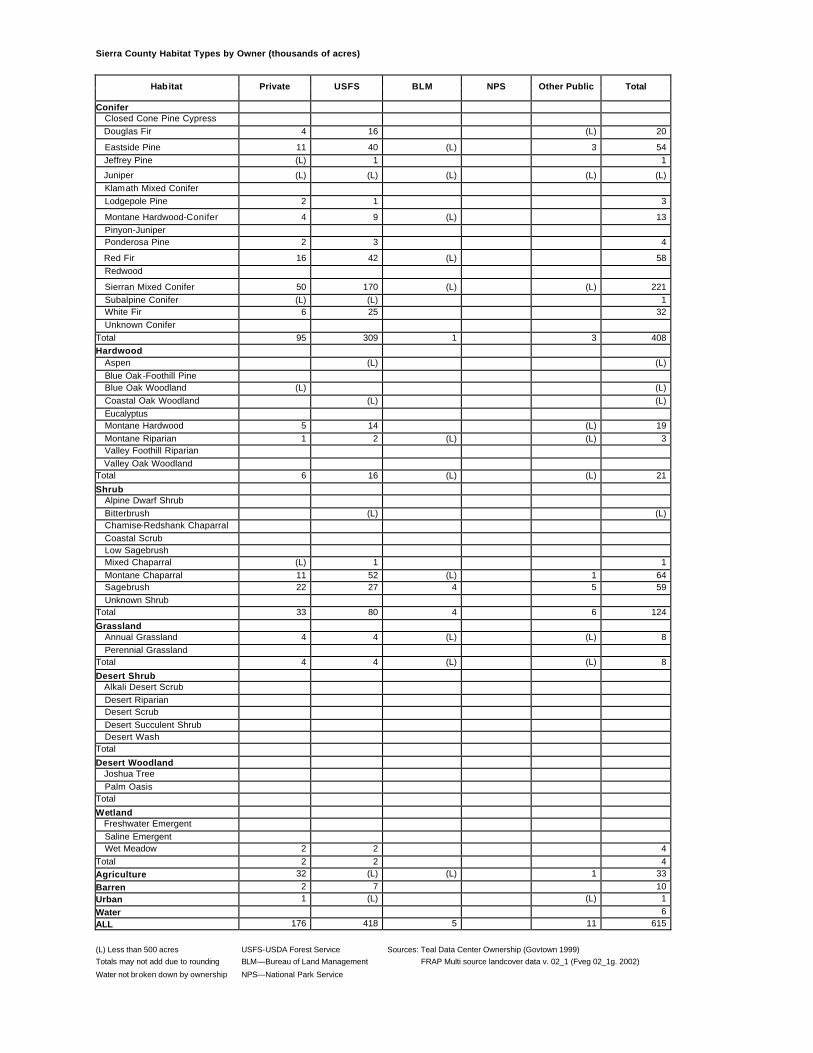
Sierra County Habitat Types by Owner (thousands of acres)
Habitat Private USFS BLM NPS Other Public Total
Conifer Closed Cone Pine Cypress Douglas Fir 4 16 (L) 20
(L) Less than 500 acres USFS-USDA Forest Service Sources: Teal Data Center Ownership (Govtown 1999) Totals may not add due to rounding BLM—Bureau of Land Management FRAP Multi source landcover data v. 02_1 (Fveg 02_1g. 2002)
Water not broken down by ownership NPS—National Park Service
Siskiyou County Habitat Types by Owner (thousands of acres)
Habitat Private USFS BLM NPS Other Public Total
Conifer Closed Cone Pine Cypress 1 12 13 Douglas Fir 77 416 3 1 496 Eastside Pine 70 171 2 (L) (L) 244 Jeffrey Pine 2 15 (L) 17 Juniper 117 25 27 2 3 174 Klamath Mixed Conifer 141 398 2 (L) 541 Lodgepole Pine 7 28 (L) 35 Montane Hardwood-Conifer 41 117 2 (L) 160 Pinyon-Juniper Ponderosa Pine 50 14 3 (L) 67 Red Fir 35 198 (L) (L) 233 Redwood Sierran Mixed Conifer 150 231 2 (L) (L) 383 Subalpine Conifer 5 33 38 White Fir 44 157 (L) 202 Unknown Conifer Total 739 1,815 40 3 5 2,601
Hardwood Aspen Blue Oak-Foothill Pine (L) 1 1 Blue Oak Woodland Coastal Oak Woodland Eucalyptus Montane Hardwood 140 123 10 2 274 Montane Riparian 3 2 (L) (L) 5 Valley Foothill Riparian Valley Oak Woodland Total 143 125 10 2 279
(L) Less than 500 acres USFS-USDA Forest Service Sources: Teal Data Center Ownership (Govtown 1999)
Totals may not add due to rounding BLM—Bureau of Land Management FRAP Multi source landcover data v. 02_1 (Fveg 02_1g. 2002) Water not broken down by ownership NPS—National Park Service
Solano County Habitat Types by Owner (thousands of acres)
Habitat Private USFS BLM NPS Other Public Total
Conifer Closed Cone Pine Cypress Douglas Fir Eastside Pine Jeffrey Pine Juniper Klamath Mixed Conifer Lodgepole Pine Montane Hardwood-Conifer (L) (L) (L) (L) Pinyon-Juniper Ponderosa Pine Red Fir Redwood Sierran Mixed Conifer Subalpine Conifer White Fir Unknown Conifer (L) (L) Total (L) (L) (L) (L) Hardwood Aspen Blue Oak-Foothill Pine 2 (L) (L) 2 Blue Oak Woodland 20 (L) (L) 20 Coastal Oak Woodland Eucalyptus (L) (L) (L) Montane Hardwood 5 (L) (L) 5 Montane Riparian Valley Foothill Riparian 1 (L) 1 Valley Oak Woodland 1 1 Total 28 (L) 1 29 Shrub Alpine Dwarf Shrub Bitterbrush Chamise-Redshank Chaparral 1 (L) (L) 2 Coastal Scrub (L) (L) (L) Low Sagebrush Mixed Chaparral 10 2 (L) 12 Montane Chaparral Sagebrush Unknown Shrub 1 (L) 1 Total 13 2 1 15
(L) Less than 500 acres USFS-USDA Forest Service Sources: Teal Data Center Ownership (Govtown 1999) Totals may not add due to rounding BLM—Bureau of Land Management FRAP Multi source landcover data v. 02_1 (Fveg 02_1g. 2002)
Water not broken down by ownership NPS—National Park Service
Sonoma County Habitat Types by Owner (thousands of acres)
Habitat Private USFS BLM NPS Other Public Total
Conifer Closed Cone Pine Cypress 12 2 1 15 Douglas Fir 67 (L) 3 70 Eastside Pine Jeffrey Pine Juniper Klamath Mixed Conifer (L) (L) Lodgepole Pine Montane Hardwood-Conifer 10 (L) (L) 11 Pinyon-Juniper Ponderosa Pine Red Fir Redwood 89 (L) 5 93 Sierran Mixed Conifer Subalpine Conifer White Fir Unknown Conifer (L) (L) Total 178 2 10 190 Hardwood Aspen Blue Oak-Foothill Pine 2 (L) (L) 3 Blue Oak Woodland (L) (L) (L) Coastal Oak Woodland 5 (L) (L) 5 Eucaly ptus 1 (L) 2 Montane Hardwood 259 1 15 275 Montane Riparian 3 (L) 3 Valley Foothill Riparian 2 (L) 2 Valley Oak Woodland (L) (L) Total 274 1 16 291 Shrub Alpine Dwarf Shrub Bitterbrush Chamise-Redshank Chaparral 3 (L) 1 4 Coastal Scrub 3 (L) 3 Low Sagebrush Mixed Chaparral 35 3 3 40 Montane Chaparral (L) (L) (L) Sagebrush Unknown Shrub 1 (L) 1 Total 42 3 4 49
(L) Less than 500 acres USFS-USDA Forest Service Sources: Teal Data Center Ownership (Govtown 1999) Totals may not add due to rounding BLM—Bureau of Land Management FRAP Multi source landcover data v. 02_1 (Fveg 02_1g. 2002)
Water not broken down by ownership NPS—National Park Service
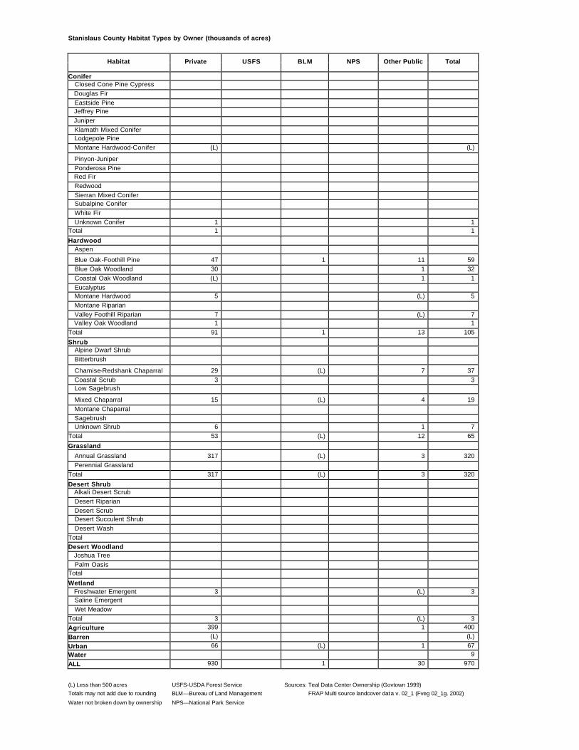
Stanislaus County Habitat Types by Owner (thousands of acres)
Habitat Private USFS BLM NPS Other Public Total
Conifer Closed Cone Pine Cypress Douglas Fir Eastside Pine Jeffrey Pine Juniper Klamath Mixed Conifer Lodgepole Pine Montane Hardwood-Conifer (L) (L)
Pinyon-Juniper Ponderosa Pine Red Fir Redwood Sierran Mixed Conifer Subalpine Conifer White Fir Unknown Conifer 1 1 Total 1 1
Hardwood Aspen
Blue Oak-Foothill Pine 47 1 11 59 Blue Oak Woodland 30 1 32 Coastal Oak Woodland (L) 1 1 Eucalyptus Montane Hardwood 5 (L) 5 Montane Riparian Valley Foothill Riparian 7 (L) 7 Valley Oak Woodland 1 1 Total 91 1 13 105
(L) Less than 500 acres USFS-USDA Forest Service Sources: Teal Data Center Ownership (Govtown 1999) Totals may not add due to rounding BLM—Bureau of Land Management FRAP Multi source landcover data v. 02_1 (Fveg 02_1g. 2002)
Water not broken down by ownership NPS—National Park Service
Sutter County Habitat Types by Owner (thousands of acres)
Habitat Private USFS BLM NPS Other Public Total
Conifer Closed Cone Pine Cypress Douglas Fir Eastside Pine Jeffrey Pine Juniper Klamath Mixed Conifer Lodgepole Pine Montane Hardwood-Conifer Pinyon-Juniper Ponderosa Pine Red Fir Redwood Sierran Mixed Conifer Subalpine Conifer White Fir Unknown Conifer Total
Hardwood Aspen Blue Oak-Foothill Pine (L) (L) Blue Oak Woodland (L) (L) Coastal Oak Woodland Eucalyptus Montane Hardwood (L) (L) Montane Riparian Valley Foothill Riparian 4 2 6 Valley Oak Woodland 8 8 Total 13 2 15
Desert Woodland Joshua Tree Palm Oasis Total Wetland Freshwater Emergent 8 3 11 Saline Emergent Wet Meadow Total 8 3 11
Agriculture 305 1 306 Barren (L) (L) (L)
Urban 12 12
Water 7 ALL 376 7 389
(L) Less than 500 acres USFS-USDA Forest Service Sources: Teal Data Center Ownership (Govtown 1999) Totals may not add due to rounding BLM—Bureau of Land Management FRAP Multi source landcover data v. 02_1 (Fveg 02_1g. 2002)
Water not broken down by ownership NPS—National Park Service
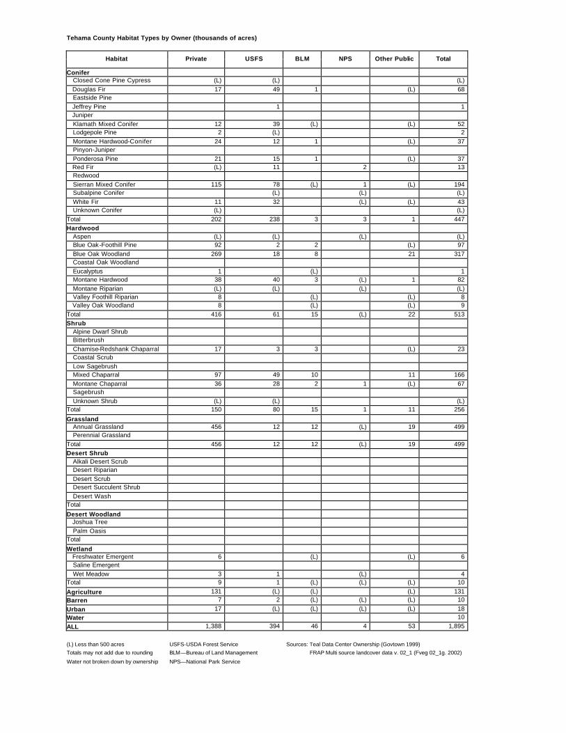
Tehama County Habitat Types by Owner (thousands of acres)
Habitat Private USFS BLM NPS Other Public Total
Conifer Closed Cone Pine Cypress (L) (L) (L) Douglas Fir 17 49 1 (L) 68 Eastside Pine Jeffrey Pine 1 1 Juniper Klamath Mixed Conifer 12 39 (L) (L) 52 Lodgepole Pine 2 (L) 2 Montane Hardwood-Conifer 24 12 1 (L) 37 Pinyon-Juniper Ponderosa Pine 21 15 1 (L) 37 Red Fir (L) 11 2 13 Redwood Sierran Mixed Conifer 115 78 (L) 1 (L) 194 Subalpine Conifer (L) (L) (L) White Fir 11 32 (L) (L) 43 Unknown Conifer (L) (L) Total 202 238 3 3 1 447 Hardwood Aspen (L) (L) (L) (L) Blue Oak-Foothill Pine 92 2 2 (L) 97 Blue Oak Woodland 269 18 8 21 317 Coastal Oak Woodland Eucalyptus 1 (L) 1 Montane Hardwood 38 40 3 (L) 1 82 Montane Riparian (L) (L) (L) (L) Valley Foothill Riparian 8 (L) (L) 8 Valley Oak Woodland 8 (L) (L) 9 Total 416 61 15 (L) 22 513 Shrub Alpine Dwarf Shrub Bitterbrush Chamise-Redshank Chaparral 17 3 3 (L) 23 Coastal Scrub Low Sagebrush Mixed Chaparral 97 49 10 11 166 Montane Chaparral 36 28 2 1 (L) 67 Sagebrush Unknown Shrub (L) (L) (L) Total 150 80 15 1 11 256
(L) Less than 500 acres USFS-USDA Forest Service Sources: Teal Data Center Ownership (Govtown 1999) Totals may not add due to rounding BLM—Bureau of Land Management FRAP Multi source landcover data v. 02_1 (Fveg 02_1g. 2002)
Water not broken down by ownership NPS—National Park Service
Trinity County Habitat Types by Owner (thousands of acres)
Habitat Private USFS BLM NPS Other Public Total
Conifer Closed Cone Pine Cypress (L) 2 2 Douglas Fir 168 574 37 1 780 Eastside Pine Jeffrey Pine (L) 4 4 Juniper (L) (L) Klamath Mixed Conifer 79 304 6 (L) 390 Lodgepole Pine (L) (L) Montane Hardwood-Conifer 36 114 4 (L) 153 Pinyon-Juniper Ponderosa Pine 7 12 2 (L) 21 Red Fir 5 49 (L) (L) 54 Redwood Sierran Mixed Conifer Subalpine Conifer 2 27 29 White Fir 11 91 1 103 Unknown Conifer Total 308 1,177 50 1 1,536 Hardwood Aspen Blue Oak-Foothill Pine 3 2 2 (L) 7 Blue Oak Woodland (L) (L) (L) Coastal Oak Woodland Eucalyptus Montane Hardwood 96 135 16 1 247 Montane Riparian 1 3 4 Valley Foothill Riparian Valley Oak Woodland Total 100 140 18 1 258 Shrub Alpine Dwarf Shrub Bitterbrush Chamise-Redshank Chaparral 2 3 (L) 5 Coastal Scrub Low Sagebrush Mixed Chaparral 19 33 5 (L) 57 Montane Chaparral 18 91 2 (L) 111 Sagebrush (L) (L) (L) Unknown Shrub (L) (L) Total 40 127 7 (L) 173
(L) Less than 500 acres USFS-USDA Forest Service Sources: Teal Data Center Ownership (Govtown 1999) Totals may not add due to rounding BLM—Bureau of Land Management FRAP Multi source landcover data v. 02_1 (Fveg 02_1g. 2002)
Water not broken down by ownership NPS—National Par k Service
Tulare County Habitat Types by Owner (thousands of acres)
Habitat Private USFS BLM NPS Other Public Total
Conifer Closed Cone Pine Cypress Douglas Fir Eastside Pine Jeffrey Pine 1 56 19 (L) 75 Juniper 4 4 Klamath Mixed Conifer
(L) Less than 500 acres USFS-USDA Forest Service Sources: Teal Data Center Ownership (Govtown 1999) Totals may not add due to rounding BLM—Bureau of Land Management FRAP Multi source landcover data v. 02_1 (Fveg 02_1g. 2002)
Water not broken down by ownership NPS—National Park Service
Tuolumne County Habitat Types by Owner (thousands of acres)
Habitat Private USFS BLM NPS Other Public Total
Conifer Closed Cone Pine Cypress Douglas Fir 2 8 1 (L) 11 Eastside Pine Jeffrey Pine (L) 14 53 (L) 67 Juniper 7 7 Klamath Mixed Conifer Lodgepole Pine 1 32 85 (L) 117 Montane Hardwood-Conifer 46 32 5 2 2 87 Pinyon-Juniper Ponderosa Pine 21 32 2 22 1 77 Red Fir 1 45 31 (L) 77 Redwood Sierran Mixed Conifer 58 199 (L) 19 3 279 Subalpine Conifer 12 36 48 White Fir (L) (L) 18 18 Unknown Conifer (L) (L) Total 128 374 8 272 6 789 Hardwood Aspen (L) 1 1 Blue Oak-Foothill Pine (L) (L) (L) 1 (L) 2 Blue Oak Woodland 24 (L) 3 1 28 Coastal Oak Woodland Eucalyptus Montane Hardwood 59 49 9 13 2 132 Montane Riparian (L) (L) 28 28 Valley Foothill Riparian Valley Oak Woodland Total 83 50 12 43 3 191 Shrub Alpine Dwarf Shrub 9 9 Bitterbrush Chamise-Redshank Chaparral 7 6 1 14 Coastal Scrub Low Sagebrush Mixed Chaparral 28 40 10 (L) 1 80 Montane Chaparral 6 38 12 (L) 57 Sagebrush 1 1 2 Unknown Shrub (L) (L) Total 41 80 17 22 2 162
(L) Less than 500 acres USFS-USDA Forest Service Sources: Teal Data Center Ownership (Govtown 1999) Totals may not add due to rounding BLM—Bureau of Land Management FRAP Multi source landcover data v. 02_1 (Fveg 02_1g. 2002)
Water not broken down by ownership NPS—National Park Service
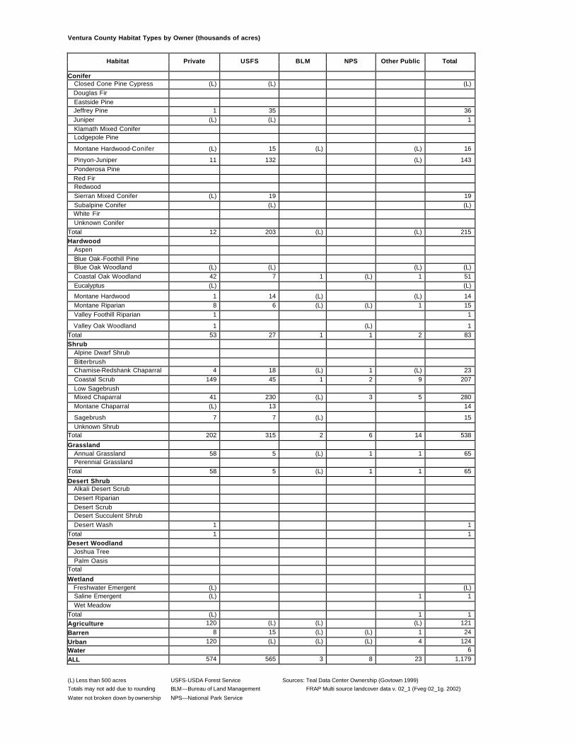
Ventura County Habitat Types by Owner (thousands of acres)
Habitat Private USFS BLM NPS Other Public Total
Conifer Closed Cone Pine Cypress (L) (L) (L) Douglas Fir Eastside Pine Jeffrey Pine 1 35 36 Juniper (L) (L) 1 Klamath Mixed Conifer Lodgepole Pine
Montane Hardwood-Conifer (L) 15 (L) (L) 16
Pinyon-Juniper 11 132 (L) 143 Ponderosa Pine Red Fir Redwood Sierran Mixed Conifer (L) 19 19 Subalpine Conifer (L) (L) White Fir Unknown Conifer Total 12 203 (L) (L) 215 Hardwood Aspen Blue Oak-Foothill Pine Blue Oak Woodland (L) (L) (L) (L) Coastal Oak Woodland 42 7 1 (L) 1 51 Eucalyptus (L) (L)
(L) Less than 500 acres USFS-USDA Forest Service Sources: Teal Data Center Ownership (Govtown 1999) Totals may not add due to rounding BLM—Bureau of Land Management FRAP Multi source landcover data v. 02_1 (Fveg 02_1g. 2002)
Water not broken down by ownership NPS—National Park Service
Yolo County Habitat Types by Owner (thousands of acres)
Habitat Private USFS BLM NPS Other Public Total
Conifer Closed Cone Pine Cypress Douglas Fir Eastside Pine Jeffrey Pine Juniper Klamath Mixed Conifer Lodgepole Pine Montane Hardwood-Conifer 1 (L) (L) 1 Pinyon-Juniper Ponderosa Pine Red Fir Redwood Sierran Mixed Conifer Subalpine Conifer White Fir Unknown Conifer Total 1 (L) (L) 1 Hardwood Aspen Blue Oak-Foothill Pine 4 1 (L) 5 Blue Oak Woodland 71 2 (L) 73 Coastal Oak Woodland Eucalyptus (L) (L) Montane Hardwood 1 (L) (L) 1 Montane Riparian Valley Foothill Riparian 3 (L) 3 Valley Oak Woodland 1 (L) 1 Total 80 3 (L) 83 Shrub Alpine Dwarf Shrub Bitterbrush Chamise-Redshank Chaparral 8 6 (L) 14 Coastal Scrub Low Sagebrush Mixed Chaparral 15 19 (L) 34 Montane Chaparral Sagebrush Unknown Shrub (L) (L) Total 24 24 (L) 48
(L) Less than 500 acres USFS-USDA Forest Service Sources: Teal Data Center Ownership (Govtown 1999) Totals may not add due to rounding BLM—Bureau of Land Management FRAP Multi source landcover data v. 02_1 (Fveg 02_1g. 2002)
Water not broken down by ownership NPS—National Park Service
Yuba County Habitat Types by Owner (thousands of acres)
Habitat Private USFS BLM NPS Other Public Total
Conifer Closed Cone Pine Cypress (L) (L) Douglas Fir 17 18 (L) (L) 36 Eastside Pine Jeffrey Pine Juniper Klamath Mixed Conifer Lodgepole Pine Montane Hardwood-Conifer 12 4 (L) (L) 16 Pinyon-Juniper Ponderosa Pine 13 1 (L) 14 Red Fir Redwood Sierran Mixed Conifer 13 16 (L) (L) 29 Subalpine Conifer White Fir Unknown Conifer (L) (L) (L) Total 55 39 1 (L) 95 Hardwood Aspen Blue Oak-Foothill Pine 2 (L) 1 3 Blue Oak Woodland 37 (L) 8 45 Coastal Oak Woodland (L) (L) Eucalyptus Montane Hardwood 39 3 (L) 3 46 Montane Riparian (L) (L) (L) (L) Valley Foothill Riparian 5 (L) 1 6 Valley Oak Woodland 1 (L) 1 Total 85 3 1 12 102 Shrub Alpine Dwarf Shrub Bitterbrush Chamise-Redshank Chaparral Coastal Scrub Low Sagebrush Mixed Chaparral 1 (L) (L) (L) 2 Montane Chaparral (L) (L) (L) Sagebrush Unknown Shrub 1 (L) (L) 1 Total 2 (L) (L) (L) 3
(L) Less than 500 acres USFS-USDA Forest Service Sources: Teal Data Center Ownership (Govtown 1999) Totals may not add due to rounding BLM—Bureau of Land Management FRAP Multi source landcover data v. 02_1 (Fveg 02_1g. 2002)
Water not broken down by ownership NPS—National Park Service