43
report HB2 Application Guide prepared for Commonwealth Transportation Board date August 1, 2015

report
HB2 Application Guide
prepared for
Commonwealth Transportation Board
date
August 1, 2015

HB2 Application Guide
i
Table of Contents 1.0 Introduction ............................................................................................................ 4
1.1 Purpose of this Document ............................................................................ 4
1.2 Overview of the HB2 Prioritization Process .............................................. 4
1.3 Application ..................................................................................................... 5
1.4 Schedule/Deadlines ...................................................................................... 6
1.5 Application Assistance .................................................................................. 7
2.0 General Project Information ................................................................................ 9 2.1 Applicant Information .................................................................................. 9
2.2 Type of Improvement ................................................................................... 9
2.3 Project Description ...................................................................................... 10
2.4 VTrans2040 Need ......................................................................................... 11
2.5 Project Location ............................................................................................ 12
3.0 Evaluation Factor Inputs..................................................................................... 13 3.1 Safety and Congestion ................................................................................ 13
3.2 Accessibility .................................................................................................. 13
3.3 Environment ................................................................................................. 14
3.4 Economic Development .............................................................................. 14
3.5 Land Use and Transportation Coordination ........................................... 18
4.0 Project Delivery and Funding ........................................................................... 23 4.1 Planning Status ............................................................................................ 23
4.2 Project Administration ................................................................................ 23
4.3 Phase and Schedule ..................................................................................... 23
4.4 Cost Estimate ................................................................................................ 26
4.5 Funding Sources .......................................................................................... 26
5.0 Attachment: Pre-Application Form ................................................................. 29


HB2 Application Guide
Cambridge Systematics, Inc. iii
List of Tables Table 1.1 VDOT Representatives: Highway Projects ............................................. 8
Table 1.2 DRPT Representatives Transit/Rail Projects ............................................. 8
Table 2.1 Examples of Project Scope Description .................................................. 10
Table 3.1 A.3 – Access to Multimodal Choices Applicant Information ................. 13
Table 3.2 E.1 – Air Quality and Energy Environmental Effect Applicant Information .................................................................................................. 14
Table 3.3 ED.1 – Project Support for Economic Development Applicant Information .................................................................................................. 15
Table 3.4 ED.1 – Project Support for Economic Development, Summary of Project Inputs ........................................................................................ 18
Table 3.5 L1 – Land Use Policy Consistency/Transportation-Efficient Land Use Support Applicant Information ................................................ 19
List of Figures Figure 2.1 Example of Project Sketch ........................................................................ 11

HB2 Application Guide
4
1.0 Introduction
1.1 PURPOSE OF THIS DOCUMENT The purpose of the Application Guide is to provide detailed information on the HB2 application process and inputs needed for project screening and scoring. A copy of the pre-application coordination form is attached to this guide and is available for download. Applicants can use this worksheet to compile all data and information necessary to complete the online application. This pre-application form may also be used to discuss project-related application questions and share compiled data to be used for the application. The Application Guide gives an overview of key inputs needed to complete the application to assist in this process.
1.2 OVERVIEW OF THE HB2 PRIORITIZATION PROCESS HB2 requires the Commonwealth Transportation Board (CTB) to develop and implement a quantifiable and transparent prioritization process for making funding decisions for capacity and safety-enhancing projects within the Six-Year Improvement Program (SYIP). The HB2 Policy Guide provides the background and details of the methodology for implementing the prioritization process.
Candidate projects will be solicited from eligible entities beginning in August of each year, with project applications due September 30th. From there, the Office of Intermodal Planning and Investment (OIPI), Virginia Department of Transportation (VDOT), and Department of Rail and Public Transportation (DRPT) staffs will screen, review, and evaluate the projects per the HB2 process from October through early January. By mid-January, the list of projects and scores will be released to the public and the CTB, allowing the CTB to consider the evaluated project lists for inclusion in the SYIP. In April, the draft SYIP will be released by the CTB, followed by public hearings to gather input. In June, the revised final SYIP will be released and considered for adoption by the CTB. The following July, the next year’s process begins again.
The HB2 application, screening, and project evaluation and scoring methods will be reviewed and potentially updated on an annual basis. This review will consider the availability of new analysis tools or data and general feedback from project applicants, the HB2 review team, and the CTB on the overall strengths and weaknesses of the entire process.
More information can be found at the following website: http://virginiahb2.org.

HB2 Application Guide
5
1.3 APPLICATION A pre-application coordination form is available for potential applicants to download and print prior to submitting application information online. The purpose of this form is to provide the potential applicants with a clear understanding of the information and data that will be required for submission in the online application.
Once the applicant is ready to submit, the online application can be completed and submitted via the following website:
http://www.virginiahb2.org/
Eligible entities must identify a staff person to serve as the Administrator for the online HB2 application system.
Designated Administrators will be provided login credentials via email. If the Administrator experiences any problems they should submit an email to [email protected].
For the online application, visit the link provided at http://www.virginiahb2.org/. Those that have completed the pre-application coordination form may transfer the information and data from the document in to the on-line application..
Note: The organization Administrator and Submitter will receive and email confirmation that the application submission has been received.
Applicants will be required to provide the following information when submitting a project:
Point of contact – Metropolitan Planning Organization (MPO), Planning District Commission (PDC), or locality (county, city, or town) project specific contact. This person will be contacted by OIPI, VDOT, or DRPT with any questions on the content of the application during the screening and scoring process.
Who will administer project? – The project applicant should confirm with VDOT or DRPT prior to submission if the project is to be locally administered. This impacts the role of the applicant and VDOT or DRPT in developing project cost estimates.
Project priority (if submitting more than one) – If the applicant is submitting more than one project, they must rank each project in priority order. During the evaluation process, VDOT and DRPT will evaluate the highest ranked priority projects first.
Detailed project description/scope – The scope should define the limits of the project, its physical and operational characteristics, and physical and/or operational footprint (see details in Section 2).

HB2 Application Guide
6
Project sketch (see Section 2.3 for an example), or operational transit routes or rail-line maps.
Project status, cost estimate and duration by phase – Cost estimate should be as realistic as possible – considering known information and should account for possible risk and contingencies. Anticipated schedule should be realistic and reflect complexity of project and identify phase durations (PE, RW, CN or other entered milestones). Please refer to the details presented in Section 4.
Measure information related to Accessibility, Economic Development, Environment, and Land Use factors
Amount of HB2 funding requested – The cost estimate reflects to total implementation cost for the project. This input details the total project cost share to be covered by HB2 funding.
Description of any non-HB2 funding committed to project– – For the remainder of project funding, the applicant should describe the funding sources involved.
Any applicable supporting documents (local resolutions, plans, studies, etc.) beyond the documents required in the information above can also be uploaded. The more relevant information provided for a project, the more robust and efficient the scoring process. Note, however, providing the succinctly relevant portions of reports rather than the entire document is preferred.
Additional information on the specific information required to complete an application is contained in this Application Guide.
Ultimately the final application for each project must be submitted prior to the September 30th deadline. A key guiding theme in developing the application was that it should not require applicants to invest significant time and resources for submission of project information, or require the use of consultants to develop an eligible application. VDOT and DRPT staff will be available to provide support and tools for applicants in compiling data and information needed for application. For more information on who can submit an application, please see Table 2.1 of the HB2 Policy Guide.
1.4 SCHEDULE/DEADLINES The application and evaluation process timeline for the first HB2 implementation cycle includes:
July – Early coordination with DRPT and VDOT prior to application submissions.
August 1 – Call for applications and notification of estimated amount and types of funding available.
August through September – Applicants coordinate with DRPT staff and VDOT District staff on candidate projects and submit applications.

HB2 Application Guide
7
September 30 – Applications due. All applications will be made public after the deadline to submit has passed. Applications may be edited after they are submitted up until the end of the application period, September 30, 2015. No additional information may be submitted after September 30, 2015 for consideration in this HB2 Cycle, except that resolutions of support from relevant entities may be submitted to [email protected] up until December 1, 2015.
If the project is submitted to promote a locally designated growth area with a code reference to the Code of Virginia (§15.2-2223.1), the project applicant submitter must confirm with OIPI prior to October 1st the validity of the code reference or the status of the designated Urban Development Area in the jurisdiction’s current comprehensive plan.
October through January – Submitted projects are screened and evaluated by OIPI, VDOT and DRPT.
Mid-January – Results of HB2 screening/scoring presented to CTB and public.
February through June – HB2-funded projects will follow existing public comment period and SYIP approval process.
1.5 APPLICATION ASSISTANCE For highway projects, localities should work initially with the VDOT RA/RE, and regional entities (MPOs/PDCs) should work with the PIM/DPM to address questions and compile information. Depending on the project, district resources will be made available to assist with refining project scopes, schedules, and estimates. These resources may include the District Project Development Engineer (PE Manager), District Bridge Engineer, District Construction Engineer, Regional ROW Manager, District Traffic Engineer/ Operations, and District Planning Manager (DPM).
A list of VDOT and DRPT contacts is shown in Table 1.1 below and will also be available through the on-line application.

HB2 Application Guide
8
Table 1.1 VDOT Representatives: Highway Projects
VDOT District Representative Phone Email Address
Bristol Donny Necessary 276-669-9956 ex. 256
Culpeper Dan Painter 540-829-7687 [email protected]
Fredericksburg Allison Richter 540-899-4103 [email protected]
Hampton Roads Dawn Odom 757-925-1581 [email protected]
Lynchburg Rick Youngblood 434-856-8331 [email protected]
Northern Virginia Andy Beacher 703-259-2239 [email protected]
Richmond Mark Riblett 804-524-6151 [email protected]
Salem Michael Gray 540-375-3565 [email protected]
Staunton Terry Short 540-332-9057 [email protected]
For transit and rail projects applicants should work with the applicable DRPT Project Manager, listed in Table 1.2 below:
Table 1.2 DRPT Representatives Transit/Rail Projects
DRPT Project Manager Representative Phone Email Address
Rail Jeremy Latimer 804-225-4016 [email protected]
Transit (Central) Patrice Strachan 804-786-7940 [email protected]
Transit (Hampton Roads) Steven Hennessee 804-225-4157 [email protected]
Transit (Southwest) Neil Sherman 804-786-1154 [email protected]
Transit (NoVa) Todd Horsley 703-259-2117 [email protected]
HB2 Application Guide
9
2.0 General Project Information Projects submitted as candidates for HB2 funding will be held to a basic standard of development to assure that they can be evaluated reliably. VDOT and DRPT intend to provide support to project submitters prior to entering applications to help applicants understand and meet expectations. Project applicants are encouraged to initiate coordination with VDOT and DRPT staff prior to the application period to ensure that candidate projects are adequately developed.
Certain projects that are based on conceptual planning-level recommendations and have not been formally scoped or defined, may require additional planning/pre-scoping level work before their benefits can be adequately assessed according to the HB2 factors and measures. Planning and pre-scoping resources exist within VDOT, DRPT, localities, regional planning bodies, and some other entities (e.g., SPR, PL, Pre-scoping, FTA 5303, FTA 5304, etc.). However, resources are unlikely to be sufficient to fund every potential request for assistance for project development related to the HB2 process. In these cases, VDOT/DRPT may recommend to applicant the need for additional study prior to HB2 submittal.
2.1 APPLICANT INFORMATION Non-profit public transportation agencies, and regional entities (Metropolitan Planning Organizations (MPO), the Northern Virginia Transportation Authority, and Planning District Commissions (PDCs)) are eligible to submit projects, along with counties, cities, and those towns that maintain their own infrastructure. A summary of the entities eligibly to submit projects for HB2 is presented in Table 2.1 of the HB2 Policy Guide.
In addition to the applicant name, the application will request a Project Point of Contact. This person should be able to provide general project information, particularly during the pre-application phase when questions about the project’s completed level of planning are being addressed.
2.2 TYPE OF IMPROVEMENT Highway, bus and rail transit, freight rail, road, operational improvements and transportation demand management projects and strategies will be considered. In the Pre-Application Coordination Form, the applicant will be asked to main or primary intent of the project. In addition, the Project Improvements section of the application provides a list of types of improvements that are associated with the project application.

HB2 Application Guide
10
For more information on project eligibility, please see the HB2 Policy Guide: Section 2, Project Eligibility and Application Process; Section 4, Project Evaluation and Rating; and, Section 5, CTB Prioritization and Programming.
2.3 PROJECT DESCRIPTION Projects submitted must have a clear scope, schedule, and budget. The Project Description should provide specific details of the proposed project and associated improvements, and describe the specific improvements and their location. The Project Description field in the on-line application has a 2,000 character limit.
More information will need to be provided regarding the phasing, schedule, and cost estimate in the section of the application titled Project Delivery/Funding.
At a minimum, the scope should define the limits of the project, its physical and operational characteristics, and physical and/or operational footprint.
Examples of adequate and inadequate scope descriptions are shown in Table 2.1.
Table 2.1 Examples of Project Scope Description
Adequate Scope/Description Inadequate Scope/Description
Improve I-64/95 interchange by extending the NB to EB ramp by 1000ft and widen NB right shoulder by 4ft
Improve I-64/95 interchange
Add one additional GS-1 through lane in each direction from Rt 602 to Rt 1 and construct dual left turn lanes WB at the Rt 1 intersection.
Widen Route 58
Install signal system at the intersection of Route 49 and 610. Construct 200ft right turn lane and 200ft taper and provide crosswalk and pedestrian heads at new signal.
Improve intersection to address congestion
A further example of an adequate scope description is provided below:

HB2 Application Guide
11
A project sketch, plan, or drawing of infrastructure improvements or maps of routes or rail-lines with transit, freight and operational improvements should be uploaded to document the project location and features, as illustrated in Figure 2.1.
Figure 2.1 Example of Project Sketch
2.4 VTRANS2040 NEED OIPI is leading the effort to develop and implement the Statewide Transportation Needs Assessment process as part of the VTrans Multimodal Transportation Plan (VMTP). The VMTP, along with the VTrans Vision Plan make up the overall Statewide Transportation Plan, VTrans2040. One of the key purposes of the Needs Assessment is to serve as a screen for projects applying for consideration through HB2.
All projects submitted for the HB2 process must pass through an initial screening process. This initial screening process is a critical step because it links the planning and programming processes to ensure the overarching transportation goals of the CTB are advanced. If a project does not meet a capacity and operations need or a safety need under the Transportation Needs Assessment of VTrans2040, it will not move forward in the HB2 process. The Transportation Needs Assessment will assess the State’s transportation needs at three scales, listed below, and will include a statewide assessment of safety needs:
Corridor of Statewide Significance (CoSS)– – Interregional or interstate travel market
Regional Networks – Intraregional travel market
HB2 Application Guide
12
Urban Development Areas (UDAs) – Local activity center market
For projects to advance under the District Grant Program (as defined in § 33.2-371), they must meet a need on:
A Corridor of Statewide Significance
A Regional Network
An Urban Development Area
A Statewide Safety Need
For projects to advance under the high priority projects program (as defined in § 33.2-370), they must meet a need on:
A Corridor of Statewide Significance
A Regional Network
In the on-line application, the applicant will be required to select the appropriate scale (or scales) in which the project meets a VTrans need. The applicant will also be able to describe how the proposed project meets a VTrans need on any of the scales selected (Corridors of Statewide Significance, Regional Network, Urban Development Area, and/or Saftey).
Details on HB1887 funding sources and project eligibility are provided in Section 2.1 of the Policy Guide. Details on the screening process are provided in Section 2.2 of the Policy Guide.
2.5 PROJECT LOCATION As part of the application, the applicant is requested to use the MapIt tool (embedded in the on-line application) to identify the project area (footprint or service limits). VDOT and DRPT will use the mapped project location for multiple aspects of the project analysis, including the safety, congestion, and accessibility measures. The project sketch, plan, or drawing of infrastructure improvements should match the limits of the area(s) drawn. For transit, TDM, rail and operational projects drawn to cover larger geographical areas, maps of coverage, routes or rail-lines with operational improvements should be uploaded to document the project affected location(s) and features details.
HB2 Application Guide
13
3.0 Evaluation Factor Inputs Detailed descriptions of the methodology that will be used to evaluate projects is contained in Appendices A through F of the HB2 Policy Guide. The following is an overview of the specific inputs that will need to be provided to complete the application.
3.1 SAFETY AND CONGESTION The safety and congestion factor areas contain measures that will be calculated by VDOT and DRPT staff using information provided on the project description and location.
Measures S.2, C.1, and C.2– – If the project is located on a non-VDOT roadway facility, the project applicant must provide existing (most recent year available) AADT by roadway segment within the project limits.
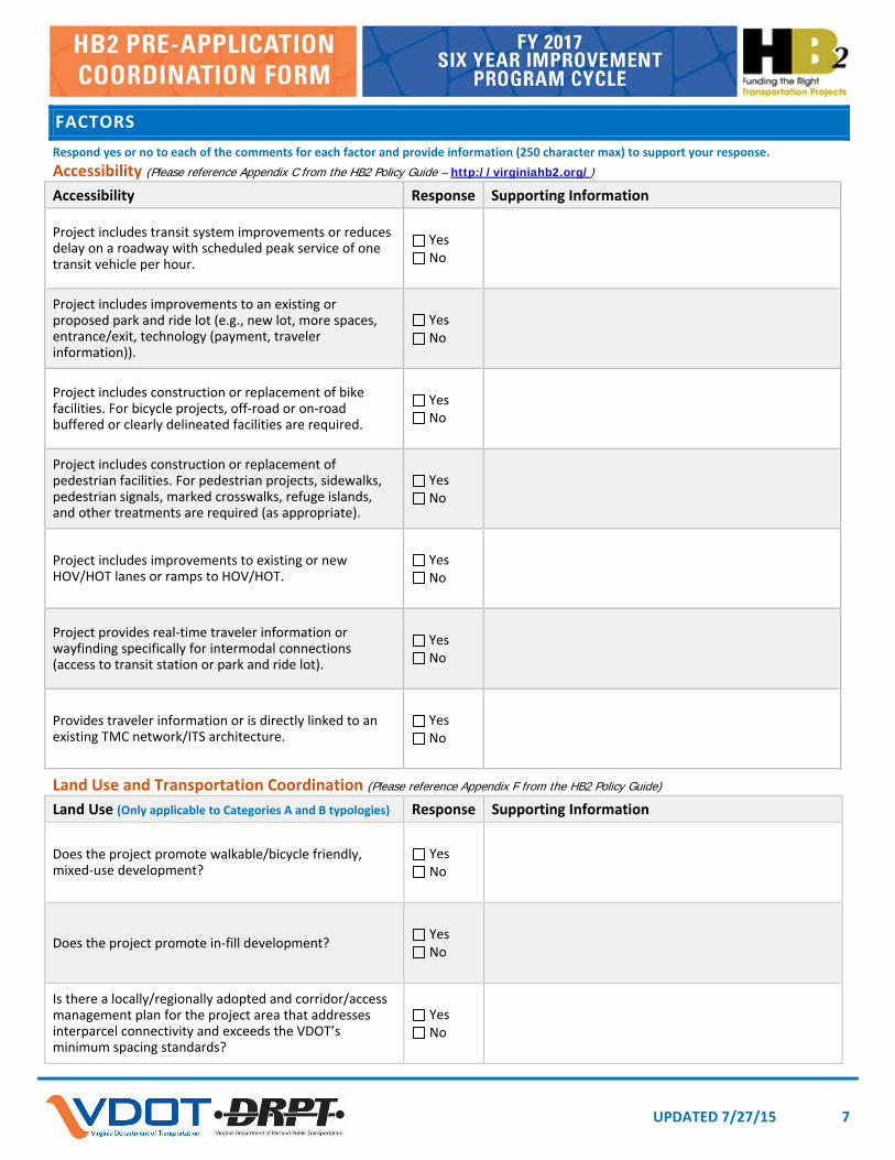
3.2 ACCESSIBILITY Measure A.3– – The applicant needs to respond Yes or No to each of the questions noted in Table 3.1. (additional space is provided in the application to explain the response if not clear in project scope)
Table 3.1 A.3 – Access to Multimodal Choices Applicant Information
Project Type (Mode) and Characteristics Applicant Response
Project includes transit system improvements or reduces delay on a roadway with scheduled peak service of 1 transit vehicle per hour.
Yes/No
Project includes improvements to an existing or proposed park-and-ride lot. Examples include: new lot, more spaces, new or improved entrance/exit, technology (payment, traveler information).
Yes/No
Project includes construction or replacement of bike facilities. For bicycle projects, off-road or on-road buffered or clearly delineated facilities are required.
Yes/No
Project includes construction or replacement of pedestrian facilities. For pedestrian projects, sidewalks, pedestrian signals, marked crosswalks, refuge islands, and other treatments are required (as appropriate).
Yes/No
Project includes improvements to existing or new HOV/HOT lanes or ramps to HOV/HOT.
Yes/No
Project provides real-time traveler information or wayfinding specifically for intermodal connections (access to transit station or park and ride lot).
Yes/No

HB2 Application Guide
14
Project Type (Mode) and Characteristics Applicant Response
Project provides traveler information or is directly linked to an existing traffic management center (TMC) network or ITS architecture.
Yes/No
3.3 ENVIRONMENT Measure E.1 – The applicant needs to respond Yes or No to each of the questions noted in Table 3.2. (additional space is provided in the application to explain the response if not clear in project scope)
Table 3.2 E.1 – Air Quality and Energy Environmental Effect Applicant Information
Project Type (Mode) and Characteristics Applicant Response
Project includes construction or replacement of bike facilities. For bicycle projects, off-road or on-road buffered or clearly delineated facilities are required.
Yes/No
Project includes construction or replacement of pedestrian facilities. For pedestrian projects, sidewalks, pedestrian signals, marked crosswalks, refuge islands, and other treatments are required (as appropriate).
Yes/No
Project includes improvements to rail transit or passenger rail facilities. Yes/No
Project includes improvements to an existing or proposed park-and-ride lot. Examples include: new lot, more spaces, new or improved entrance/exit, technology (payment, traveler information).
Yes/No
Project includes bus facility improvements or reduces delay on a roadway with scheduled peak service of 1 transit vehicle per hour.
Yes/No
Project reduces traffic delay at a congested intersection, interchange, or other bottleneck with a high percentage of truck traffic (greater than 8 percent of AADT).
Yes/No
Project includes improvements to freight rail network or intermodal (truck to rail) facilities/ports/terminals.
Yes/No
Project include special accommodations for hybrid or electric vehicles, or space or infrastructure for electric vehicle parking/charging).
Yes/No
Project includes energy efficient infrastructure or fleets, including: hybrid or electric buses, LED lights and signals, electronic/open road tolling, alternative energy infrastructure (e.g., roadside solar panels).
Yes/No
3.4 ECONOMIC DEVELOPMENT Measure ED.1– – The focus of this measure is on project consistency/support of local/county/PDC/regional economic development plans and support of real, planned non-residential development (residential-only developments are not considered) within the project corridor (what is included in the project corridor is clarified in steps below). Project assessment is based on the use of a checklist,
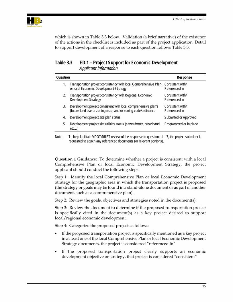
HB2 Application Guide
15
which is shown in Table 3.3 below. Validation (a brief narrative) of the existence of the actions in the checklist is included as part of the project application. Detail to support development of a response to each question follows Table 3.3.
Table 3.3 ED.1 – Project Support for Economic Development Applicant Information
Question Response
1. Transportation project consistency with local Comprehensive Plan or local Economic Development Strategy
Consistent with/ Referenced in
2. Transportation project consistency with Regional Economic Development Strategy
Consistent with/ Referenced in
3. Development project consistent with local comprehensive plan’s (future land use or zoning map, and or zoning code/ordinance
Consistent with/ Referenced in
4. Development project site plan status Submitted or Approved
5. Development project site utilities status (sewer/water, broadband, etc…)
Programmed or In place
Note: To help facilitate VDOT/DRPT review of the response to questions 1 – 3, the project submitter is requested to attach any referenced documents (or relevant portions).
Question 1 Guidance: To determine whether a project is consistent with a local Comprehensive Plan or local Economic Development Strategy, the project applicant should conduct the following steps:
Step 1: Identify the local Comprehensive Plan or local Economic Development Strategy for the geographic area in which the transportation project is proposed (the strategy or goals may be found in a stand-alone document or as part of another document, such as a comprehensive plan).
Step 2: Review the goals, objectives and strategies noted in the document(s).
Step 3: Review the document to determine if the proposed transportation project is specifically cited in the document(s) as a key project desired to support local/regional economic development.
Step 4: Categorize the proposed project as follows:
If the proposed transportation project is specifically mentioned as a key project in at least one of the local Comprehensive Plan or local Economic Development Strategy documents, the project is considered “referenced in”
If the proposed transportation project clearly supports an economic development objective or strategy, that project is considered “consistent”

HB2 Application Guide
16
Question 2 Guidance: To determine whether a project is consistent with the Regional Economic Development Strategy, the project applicant should conduct the following steps:
Step 1: Identify the Regional Economic Development Strategy for the geographic area in which the transportation project is proposed (the strategy or goals may be found in a stand-alone document or as part of another document).
Step 2: Review the goals, objectives and strategies noted in the document(s).
Step 3: Review the document to determine if the proposed transportation project is specifically cited in the document(s) as a key project desired to support local/regional economic development.
Step 4: Categorize the proposed project as follows:
If the proposed transportation project is specifically mentioned as a key project in the Regional Economic Development Strategy, the project is considered “referenced in”
If the proposed transportation project clearly supports an economic development objective or strategy, that project is considered “consistent”
Question 3 Guidance: To determine whether each development site (do not include residential only developments) within the project corridor (1 mile buffer) is consistent with the local Comprehensive Plan future land use or zoning map, and or zoning code/ordinance, the project sponsor should conduct the following steps:
Step 1: Identify the local Comprehensive Plan future land use or zoning map, and the zoning code/ordinance for the geographic area in which the transportation project is proposed.
Step 2: Review future land use or zoning map and or zoning code/ordinance for the project area.
Step 3: List each development site within 1 mile of the project corridor (do not include residential only developments) and for each, provide the projected square footage and distance from the project corridor.
Step 4: Categorize each development site as follows:
Is the development project specifically mentioned as a key project in the local comprehensive plan?
Is the development project considered “consistent” with the local comprehensive plan (future land use or zoning map) and or zoning code/ordinance?
Question 4 Guidance:
To assess development project site plan status, the applicant must provide information regarding the status of development review and approval of development projects adjacent to the project corridor (for the same set of

HB2 Application Guide
17
development projects identified in Question 3). The information required in the application includes:
Has the development site plan been “approved”? (or the equivalent, dependent upon local terminology)
Has the site plan been “submitted”?
Question 5 Guidance:
To assess each development project site’s (for the same set of development projects identified in Question 3) utility provision status, the applicant must provide information regarding utility systems and provision, including current and planned utilities for each individual development site.
Does the development project site have utilities (sewer/water, broadband, etc…) that have been programmed?, or
Does the development project site have utilities (sewer/water, broadband, etc…) that are in place?
A summary of all information required for the transportation project and each associated development project within the project corridor, and the corresponding points awarded, is provided in Table 3.4 below.

HB2 Application Guide
18
Table 3.4 ED.1 – Project Support for Economic Development, Summary of Project Inputs
Economic Development (ED.1) Tools – Use Google Earth or tool such as – http://www.freemaptools.com/area-calculator.htm
Question 1
Transportation Project consistency with Local Comprehensive Plan/Economic Development Strategy
Question 2
Transportation Project consistency with Regional Economic Development Strategy
Question 3
Development consistent with Comprehensive Plan/Zoning
Question 4
Development site plan status
Question 5
Development site utilities status
Development proposed (or projected) building square footage
Distance from Project
Transportation Project
Consistent With / Referenced In
Consistent With / Referenced In
[Site 1 Name] Consistent With /
Referenced In Submitted / Approved
Programmed / In place
Total sf mi.
[Site 2 Name] Consistent With / Referenced In
Submitted / Approved
Programmed / In place Total sf mi.
[Site 3 Name] Consistent With /
Referenced In Submitted / Approved
Programmed / In place
Total sf mi.
[Site 4 Name] Consistent With / Referenced In
Submitted / Approved
Programmed / In place Total sf mi.
[Site 5 Name] Consistent With /
Referenced In Submitted / Approved
Programmed / In place
Total sf mi.
3.5 LAND USE AND TRANSPORTATION COORDINATION Measure L.1 – Projects applications should indicate the project’s ability to address the policy and planning criteria listed in Table 3-4. A project is assessed for how well the project (or the jurisdiction or region that the project is located in) addresses the land use evaluation questions. With the exception of the question regarding in-fill development, points are assessed based on yes/no responses. VDOT/DRPT staff will review the project application against these criteria to confirm consistency. See the guidance provided for specific steps and resources to support response to the evaluations questions in Table 3.5.

HB2 Application Guide
19
Table 3.5 L1 – Land Use Policy Consistency/Transportation-Efficient Land Use Support Applicant Information
Policy and Planning Criteria Applicant Response
1. Does the project promote walkable/bicycle friendly, mixed-use development? Yes/No
2. Does the project promote in-fill development? Yes/No
3. Is there a locally/regionally adopted corridor/access management plan for the project area that addresses interparcel connectivity and exceeds VDOT’s minimum spacing standards?
Yes/No
For all questions, applicants should provide associated documentation and rationalization for “Yes” answers. HB2 staff will review the application details and clarify information with submitters as necessary.
1. Does the project promote walkable/bicycle friendly, mixed-use development?
To answer “Yes,” you should be able to answer “Yes” to both A and B questions below:
a. Is the project buffer area (¼ mile) zoned for, or indicated on future land use maps, as “mixed use,” or the equivalent.
b. Does the project add or improve pedestrian or bicycle facilities and/or operations? Or does the project add or improve transit facilities and/or operations?
To support the applicant response, more information about the types of projects that would be appropriate for “Yes” responses is provided below, please use this information to assess the project and the land use at/adjacent to the project.
Assessment of a Project or Project Component
Question 1A. To confirm that the proposed project is within or directly adjacent to a place zoned for mixed use development, please follow the steps below:
Step 1: Draw a ¼ mile buffer around the project boundaries.
Step 2: Review the existing zoning and planned land use: Is any of the land within the buffer drawn in Step 1 above currently zoned as mixed use or does the future land use plan for the jurisdiction identify any of the land within the buffer as planned mixed-use development?
Question 1B. To assess if the project “enhances a walkable/bicycle friendly environment” the guide provides the following examples of project types below:
Bicycle and pedestrian facilities. Does the project incorporate facilities to improve bicycle and pedestrian mobility and safety? For example, bicycle projects could include off-road or on-road buffered or clearly delineated
HB2 Application Guide
20
facilities. Pedestrian projects examples might include pedestrian signals, marked crosswalks, refuge islands, and other treatments are required (as appropriate). For more information, you may also refer to DRPT Multimodal System Design Guidelines, Chapter 6 “Key Intersection Elements for Transit, Pedestrians and Bicyclists”1
Multimodal street improvements. Projects that improve the grid of streets by adding a new street to shorten blocks, or alter a major roadway to a boulevard design. For more information, you may also refer to DRPT Multimodal System Design Guidelines and the associated VDOT Appendix B(2) “Multimodal Design Standards for Mixed-Use Centers”2
Transit center or facility improvements at or adjacent to mixed-use development.
2. Does the project promote in-fill development?
Does the project support local/regional redevelopment or in-fill development?
“In-fill development” includes development or redevelopment that occurs on an underutilized or vacant tract of land encompassed by a larger area that is mostly developed. For example, in-fill development might include the construction of a new building in a small town center on a parcel that was previously vacant. Another example might be construction a development on a parcel that was previously a surface parking lot in an urban center. Examples of development that should not be included as in-fill include development projects on “greenfields” (large tracts of undeveloped land), projects that require expansion of the service utility area, and projects that are to be built in areas that are largely undeveloped.
To respond to this question, please assess the planned or proposed projects identified and used for calculation in the Economic Development measure 1 (ED.1) to determine if these projects are in-fill projects. In addition, please consider planned or active residential in-fill development projects (these are excluded from ED.1). If any of these projects meet the definition of in-fill, the answer should be “Yes.” The applicant is requested to note within the explanation which specific projects meet the in-fill definition.
3. Is there a locally/regionally adopted corridor/access management plan for the project area that addresses interparcel connectivity and exceeds VDOT’s minimum spacing standards?
For more information on VDOT’s minimum entrance spacing standards, see Appendix F of the Virginia Road Design Manual.
1 http://www.drpt.virginia.gov/media/1055/drpt_mmsdg_final_full.pdf.
2 http://www.extranet.vdot.state.va.us/locdes/Electronic_Pubs/2005%20RDM/AppendB(2).pdf.

HB2 Application Guide
21
Corridor access management plans offer flexibility in the application of the access management regulations and standards to meet the special needs of different areas of the state. In addition to entrance spacing, corridor/access management plans should include recommendations for cross-parcel access, shared entrances. These plans may also establish a network of parallel roadways to the main corridor that would serve to divert traffic. The plans may include recommendations regarding turn lanes, limiting entrance movements, signal synchronization, closing median crossovers and locations for new median crossovers.

HB2 Application Guide
23
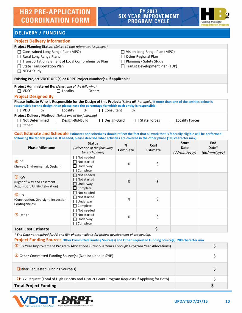
4.0 Project Delivery and Funding
4.1 PLANNING STATUS The applicant will be asked to provide information on the types of planning studies or plans that have identified the need, scope, design, etc. for the proposed improvement. Specifically, the application will ask whether the project was included in any of the following:
Constrained Long Range Plan (MPO)
Vision Long-Range Plan (MPO)
Rural Long Range Plans
Other Regional Plan
Transportation Element of Local Comprehensive Plan
Planning / Safety Study
State Transportation Plan
Transit Development Plan (TDP)
National Environmental Policy Act (NEPA) Study
4.2 PROJECT ADMINISTRATION Localities can indicate their desire to administer the project as part of the HB2 application process. Per the HB2 Implementation Policy Guide, estimates to be used for scoring purposes on proposed locally administered projects should still be validated by VDOT and/or DRPT staff. Any projects selected for funding that fall under DRPT oversight should follow the DRPT Project Partnership process. Any projects selected for funding that fall under VDOT oversight should follow the guidelines as outlined in the Locally Administered Projects Manual.
4.3 PHASE AND SCHEDULE At a minimum, the schedule should clearly define the expected process for further project development including key milestones, work activities, related activities, and approvals/approval timelines. The schedule should be realistic and reflect the complexity of the project and identify the ad date, and the duration for each project phase (PE, RW, CN or other entered milestones).
HB2 Application Guide
24
Preliminary Engineering (PE) Phase
For existing underway phases, % complete indicates level of completion to date for all required tasks or milestones identified as a part of the phase; this will be used to provide qualitative feedback to the CTB regarding project efforts to date (e.g., NEPA complete, Preliminary Field Inspection level plans, RW level plans, etc).
For future planned phases, % complete should be “0.”
Phase estimate should account for the total cost of the phase to include future planned costs and costs of any previous work or accomplishments to date on existing phases. To the extent possible, PE phase costs should attempt to exclude planning level activities unless directly assigned to the project’s budget. If planning level activities are included as a part of the phase’s cost estimate, the funding sources utilized to accomplish those activities should be included under the Project Funding Sources described below.
For existing underway phases, phase start date should reflect the date in which the state or applicant received Federal authorization or state equivalent to begin the PE phase (or planning efforts if those efforts are being included in the estimate/funding) or applicant began substantial preliminary engineering activities such as survey, environmental, or design related activities such as initiating in-house or consultant procured design.
For a future planned PE phase, all applicants should assume a start date of August 1, 2016. Actual dates will depend on actions required to obtain Federal and/or state authorization to begin the phase.
Phase end date is not required for the PE phase as it is understood that the PE phase may run concurrently with future planned phases of work.
RW Phase (Right-of-way and Easement Acquisition, Utility Relocation)
For existing underway phases, % complete indicates level of completion to date for all required tasks or milestones identified as a part of the phase.
For future planned phases, % compete should be “0.”
Phase estimate should account for the total cost of the phase to include future planned costs and costs of any previous work or accomplishments to date on existing phases. To the extent possible, RW phase costs should attempt to exclude the value of donated land or easements or other RW phase related in-kind contributions. If such aspects are included as a part of the phase’s cost estimate, the applicant should denote that the value of such items are reflected as “Local Funds” in the Project Funding Sources described below under Previous or Future Commitments depending on the current status of project development.

HB2 Application Guide
25
For existing underway phases, phase start date should reflect the date in which the state or applicant received Federal authorization or state equivalent to begin RW phase or the date in which the applicant issued notice to proceed to in house or consultant staff to proceed with the RW acquisitions or Utility Relocations.
Phase end date is not required for the RW phase as it is understood that the RW phase may run concurrently with future planned phases of work.
CN Phase (Construction)
It is assumed that the CN phase status should be “not started”– – this program is to fund projects for construction and while a PE and RW phase may or may not be required or has already been completed, the CN phase is required.
% complete should be “0” for most projects. If it is greater than “0%” complete, an explanation must be provided.
Phase estimate should account for the total planned cost of the Construction phase to include the expected cost of construction, appropriate construction engineering and inspection costs, appropriate contingencies, and any appropriate non-contract specific costs (such as state or local police costs, etc.). To the extent possible, CN phase costs should attempt to exclude the estimated costs of in-plan utility betterment that is expected to be at the locality or other regional entity’s cost unless the project has progressed sufficiently through design that a more accurate estimate for such costs has been established. If such aspects are included as a part of the phase’s cost estimate, the applicant should denote that the value of such items are reflected as “Local Funds” in the Project Funding Sources table below under Previous or Future Commitments depending on the current status of project development.
For CN phases, the applicant should provide a planned start date that reflects the anticipated date that the state and/or applicant is expecting to advertise the construction phase to industry. For multi-segment or multi-phase construction phases, the planned start date should reflect the expected date the next segment of construction could begin if appropriate funding was programmed to the project. The construction phase estimate should be inflated to the planned construction start date.
The applicant should provide a planned end date that reflects the anticipated date of fixed completion for the construction project. This date is important in order for the state to adequately program project funding in accordance with the project’s projected schedule and cash flow requirements.

HB2 Application Guide
26
4.4 COST ESTIMATE Accurate cost estimates are critical because cost impacts the project score and cost estimate increases could force the project to be rescored in subsequent HB2 cycles. VDOT and DRPT will assist applicants with the development of cost estimates. Prior to submitting project applications, applicants should work in conjunction with VDOT and DRPT staff to develop reliable cost estimates as part of the application process.
For projects in which the applicant requests VDOT to administer the project, VDOT will be responsible for providing the applicant with a cost estimate for each project application. If the applicant has provided an estimate, VDOT will be required to validate the estimate for use on each project application.
For projects in which the applicant requests to locally administer the project (and for all DRPT oversight projects), the applicant may provide a cost estimate for each project application, however VDOT and/or DRPT staff must validate the estimate for use on each project application
If there is disagreement concerning the estimate that cannot be resolved between the applicant and the VDOT/DRPT local contact, the applicant may request resolution from the VDOT District Engineer/Administrator or the DRPT Director.
At a minimum, the cost estimate should be as realistic as possible and should account for applicable risk and contingencies based on the size and complexity of the project. Projects incurring one-time and ongoing operations and non-construction costs (i.e., purchase of transit vehicles) should clearly identify those costs.
VDOT’s Project Cost Estimating System (PCES) workbook is the preferred tool for developing cost estimates for roadway projects. If quantities are known, TRANSPORT can be used for cost estimates. It is important that the applicant works directly with VDOT staff through project specific scope and costing issues.
For the HB2 application, the cost estimate for each phase should be based on the schedule shown in the application. To the extent possible, document all assumptions and contingencies used.
4.5 FUNDING SOURCES
Six Year Improvement Program Allocations
Provide the total amount of allocations listed in the most recently adopted Six Year Improvement Program (SYIP) for all fiscal years, regardless of the type of funding. A VDOT UPC or DRPT project number must be provided.

HB2 Application Guide
27
Other Committed Funding Sources (not shown in SYIP)
Provide the total amount of funding committed to the project that is not already shown in the most recently adopted SYIP. This may include local funding, proffers, in-kind contributions, etc.
Other Requested Funding Sources
Provide the total amount of funding requested for the project that is not already shown in the most recently adopted SYIP. This may include applications for VDOT or DRPT funding programs (Revenue Sharing, TAP, FTA Programs), regional funding (CMAQ/RSTP), or local funds requested from the Board of Supervisors (BOS) or City/Town Council. An explanation of the source of the requested funding must be provided.
HB2 Request (Total of High Priority and District Grant Program Requests, if Applying for Both)
Provide the total amount of funding requested through the HB2 Grant programs. If funds are being requested from both grant programs, the total request should be entered. This should reflect the difference between the total project cost estimate (to include all phases) and the sum of SYIP, committed, and requested fund sources. Projects selected for funding under HB2 that are Federally eligible, will be developed as Federal projects.

HB2 Application Guide
29
5.0 Attachment: Pre-Application Form

UPDATED 7/27/15 1
This form was developed to provide preliminary guidance to assist HB2 applicants with the development and refinement of potential projects to be considered through the HB2 process. This form is not the official application, so all applicants will be required to enter project requests into the HB2 Web Application portal that will be available starting in August. When navigating between fields in this form, only use the Tab key. For specific help information on the data entry fields, refer to either the Status Bar on the bottom left of the window or the associated Pre‐Application Cordination Form Help Information. Fields with additional help information are denoted with numbers.
GENERAL DATE (MM/DD/YYYY):
Applicant Information (Select one of the following) MPO PDC NVTA Public Transit Agency Local Government (City, Town, County)
Applicant Name:
Project Point of Contact Information The primary person that the State can contact for information during the screening process. Point of Contact Name:
Point of Contact Phone Number:
Point of Contact Email Address:
Project Information Project Title: 60 character max, Project Description: 2,000 character max, VTRANS Need: 1,300 character max
Project Title:
Principal Improvement: (Select one of the following) The main or primary intent of the proposed improvement. Highway Bike/Pedestrian Bus Transit Rail Transit Freight Rail TDM
Does This Project Include Improvements to Non‐VDOT Maintained Roadways? Yes No If yes, please enter available traffic volume data on those roadways in Attachment A.
Project Description:
HB2 Need Categories: (Select all that apply) The sponsoring applicant must meet the eligibility requirements for submittal based on the selected project type as outlined in Table 2.1 of the HB2 Policy Guide (http://virginiahb2.org/).
Corridor of Statewide Significance Regional Network Urban Development Area Safety Application Program: (Select all that apply) HB 1887 funding eligibility is based on the selected HB 2 need category as outlined in Table 1.1 of the HB2 Policy Guide (http://virginiahb2.org/).
High Priority District Grant
How Does This Project Address a VTrans 2040 Need?

UPDATED 7/27/15 2
LOCATION
Please include a project sketch, design plan and/or map that details the location, elements, and limits of the proposed improvements. For the HB2 Web Application, applicants will be required to locate the proposed project on a map. The space provide below can be used to import a sketch of the project.
VDOT District(s) (Select all that apply)
Bristol Culpeper Fredericsburg Hampton Roads
Lynchburg Northern Virginia Richmond Salem Staunton
In What Jurisdiction(s) is this Project Located?
Project Sketch

UPDATED 7/27/15 3
FEATURES
Project Improvements There can be multiple project improvements associated with one project application. Please use the lists provided below, broken down by principal improvement, to identify all of the improvements that are associated with your project application. In the description (350 character max), please provide specific information regarding the improvements. Highway (Select all that apply)
Description (Type, Quantity, and Location)
Add New Through Lanes(s)
Roadway on New Alignment
Roadway Reconstruction / Realignment
Widen Existing Lane(s) (No New Lanes)
Shoulder Improvement(s)
Access Management
Road Diet
Improve Rail Crossing
Managed Lane(s) (HOV/HOT/Shoulder)
New Interchange
Improve Grade‐Separated Interchange
Ramp Improvement(s)
New Intersection
Intersection Improvement(s)

UPDATED 7/27/15 4
FEATURES
Project Improvements (continued)
Highway (continued) (Select all that apply)
Description (Type, Quantity, and Location)
Turn Lane Improvement(s)
New Traffic Signal / Signal Optimization
ITS Improvement(s)
New Bridge
Improve / Replace Existing Bridge
Highway Other
Bike / Pedestrian (Select all that apply)
Description (Type, Quantity, and Location)
Add / Construct Bike Lane
Paved Shoulder (Minimum 4‐ft Ridable Surface)
Construct Shared‐Use Path
Construct Sidewalk
Improve Bike / Pedestrian Crossing (At Grade)
Improve Bike / Pedestrian Crossing (Grade Separated)
Bike / Pedestrian Other

UPDATED 7/27/15 5
FEATURES
Project Improvements (continued)
Bus Transit (Select all that apply)
Description (Type, Quantity, and Location)
Provide New Service Routes
Increase Existing Service – Additional Vehicles or Increased Frequency
Convert Existing Lane to Dedicated Bus Service Lane
Construct Bus Stop / Shelter
Improve Bus Stop / Shelter
Bus Transit Other
Rail Transit (Select all that apply)
Description (Type, Quantity, and Location)
Additional Track
Increase Existing Rail Service – Additional Cars or Routes
New Terminal
New Station
Station or Terminal Improvements
Rail Transit Other

UPDATED 7/27/15 6
FEATURES
Project Improvements (continued)
Freight Rail (Select all that apply)
Description (Type, Quantity, and Location)
Additional Track
Freight Haul Increase
New Rail Yard
Rail Yard Improvements
Heavy Rail Other
Travel Demand Management (TDM) (Select all that apply)
Description (Type, Quantity, and Location)
New Park and Ride Lot
Improve Park and Ride Lot
New / Expanded Vanpool or On‐Demand Transit Service
TDM Other
Right of Way Description (Type, Quantity, and Location)
Right of Way / Easements Acquisition Required
UPDATED 7/27/15 7
FACTORS
Respond yes or no to each of the comments for each factor and provide information (250 character max) to support your response. Accessibility (Please reference Appendix C from the HB2 Policy Guide – http://virginiahb2.org/)
Accessibility Response Supporting Information
Project includes transit system improvements or reduces delay on a roadway with scheduled peak service of one transit vehicle per hour.
Yes No
Project includes improvements to an existing or proposed park and ride lot (e.g., new lot, more spaces, entrance/exit, technology (payment, traveler information)).
Yes No
Project includes construction or replacement of bike facilities. For bicycle projects, off‐road or on‐road buffered or clearly delineated facilities are required.
Yes No
Project includes construction or replacement of pedestrian facilities. For pedestrian projects, sidewalks, pedestrian signals, marked crosswalks, refuge islands, and other treatments are required (as appropriate).
Yes No
Project includes improvements to existing or new HOV/HOT lanes or ramps to HOV/HOT.
Yes No
Project provides real‐time traveler information or wayfinding specifically for intermodal connections (access to transit station or park and ride lot).
Yes No
Provides traveler information or is directly linked to an existing TMC network/ITS architecture.
Yes No
Land Use and Transportation Coordination (Please reference Appendix F from the HB2 Policy Guide)
Land Use (Only applicable to Categories A and B typologies) Response Supporting Information
Does the project promote walkable/bicycle friendly, mixed‐use development?
Yes No
Does the project promote in‐fill development? Yes No
Is there a locally/regionally adopted and corridor/access management plan for the project area that addresses interparcel connectivity and exceeds the VDOT’s minimum spacing standards?
Yes No

UPDATED 7/27/15 8
FACTORS
Environment (Please reference Appendix D from the HB2 Policy Guide)
Environment Response Supporting Information
Project includes construction or replacement of bike facilities. For bicycle projects, off‐road or on‐road buffered or clearly delineated facilities are required.
Yes No
Project includes construction or replacement of pedestrian facilities. For pedestrian projects, sidewalks, pedestrian signals, marked crosswalks, refuge islands, and other treatments are required (as appropriate).
Yes No
Project includes improvements to rail transit or passenger rail facilities.
Yes No
Project includes improvements to an existing or proposed park‐and‐ride lot (e.g., new lot, more spaces, entrance/exit, technology (payment, traveler information)).
Yes No
Project includes bus facility improvements or reduces delay on a roadway with scheduled peak service of one transit vehicle per hour.*
Yes No
Project includes improvements to freight rail network or intermodal (truck to rail) facilities/ports/terminals.
Yes No
Project include special accommodations for hybrid or electric vehicles, or space or infrastructure for electric vehicle parking/charging).
Yes No
Project includes energy efficient infrastructure or fleets, including: hybrid or electric buses, LED lights and signals, electronic/open road tolling, alternative energy infrastructure (e.g., roadside solar panels).
Yes No

UPDATED 7/27/15 9
FACTORS
Economic Development (Please reference Appendix E from the HB2 Policy Guide) Commercial, industrial or mixed‐used developments only. Transportation Project – Consistency with Local Comprehensive Plan or Local Economic Development Strategy:(Select one of the following)
Consistent with Referenced in (documentation will be required)
Transportation Project – Consistency with Regional Economic Development Strategy: (Select one of the following) Consistent with Referenced in (documentation will be required)
Site Name:
Development Project (Consistent With Locality Comprehensive Plan / Zoning) (Select one of the following)
Consistent with Comprehensive Plan Future Land UseSpecific Reference (documentation will be required)
Development Project (Site Planning Status) (Select one of the following)
Submitted Site Plan (documentation will be required)Approved Site Plan (documentation will be required)
Development Project (Site Utilities Status) (Select one of the following)
Programmed (documentation will be required) In Place
Development Project (Proposed / Projected Building Square Footage)
square feet
Does Transportation Project Provide Direct or Indirect Access to the Development Site?
Provides Primary Access to the Site or is Adjacent to the Site Enhances Access Near the Site But is Not Adjacent to the Site
Driving Distance to Development Project From Transportation Project
miles
Additional Economic Development Sites
Site Name:
Development Project (Consistent With Locality Comprehensive Plan / Zoning) (Select one of the following)
Consistent with Comprehensive Plan Future Land Use Specific Reference (documentation will be required)
Development Project (Site Plan Status) (Select one of the following)
Submitted Site Plan (documentation will be required)
Approved Site Plans (documentation will be required)
Development Project (Site Utilities Status) (Select one of the following)
Programmed (documentation will be required) In Place
Development Project (Proposed / Projected Building SquareFootage)
square feet
Does Transportation Project Provide Direct or Indirect Access to the Development Site?
Provides Primary Access to the Site or is Adjacent to the Site Enhances Access Near the Site But is Not Adjacent to the Site
Driving Distance to Development Project From Transportation Project
miles
Site Name:
Development Project (Consistent With Locality Comprehensive Plan / Zoning) (Select one of the following)
Consistent with Comprehensive Plan Future Land UseSpecific Reference (documentation will be required)
Development Project (Site Plan Status) (Select one of the following)
Submitted Site Plan (documentation will be required)Approved Site Plans (documentation will be required)
Development Project (Site Utilities Status) (Select one of the following)
Programmed (documentation will be required) In Place
Development Project (Proposed / Projected Building SquareFootage)
square feet
Does Transportation Project Provide Direct or Indirect Access to the Development Site?
Provides Primary Access to the Site or is Adjacent to the Site Enhances Access Near the Site But is Not Adjacent to the Site
Driving Distance to Development Project From Transportation Project
miles
To identify information for additional development sites, make copies of this sheet.
UPDATED 7/27/15 10
11
DELIVERY / FUNDING
Project Delivery Information Project Planning Status: (Select all that reference this project)
Constrained Long Range Plan (MPO) Vision Long‐Range Plan (MPO) Rural Long Range Plans Other Regional Plan Transportation Element of Local Comprehensive Plan Planning / Safety Study State Transportation Plan Transit Development Plan (TDP) NEPA Study
Existing Project VDOT UPC(s) or DRPT Project Number(s), if applicable:
Project Administered By: (Select one of the following) VDOT Locality Other:
Project Designed By Please Indicate Who is Responsible for the Design of this Project: (Select all that apply) If more than one of the entities below is responsible for the design, then please note the percentage for which each entity is responsible.
VDOT % Locality % Consultant %
Project Delivery Method: (Select one of the following) Not Determined Design‐Bid‐Build Design‐Build State Forces Locality Forces Other:
Cost Estimate and Schedule Estimates and schedules should reflect the fact that all work that is federally eligible will be performed following the federal process. If needed, please describe what activities are covered in the other phase (100 character max).
Phase Milestone Status
(Select one of the following for each phase)
% Complete
Cost Estimate
Start Date
(dd/mm/yyyy)
EndDate*
(dd/mm/yyyy)
PE (Survey, Environmental, Design)
Not needed Not started Underway Complete
% $
RW (Right of Way and Easement Acquisition, Utility Relocation)
Not needed Not started Underway Complete
% $
CN (Construction, Oversight, Inspection, Contingencies)
Not needed Not started Underway Complete
% $
Other
Not needed Not started Underway Complete
% $
Total Cost Estimate $ * End Date not required for PE and RW phases – allows for project development phase overlap.
Project Funding Sources Other Committed Funding Source(s) and Other Requested Funding Source(s): 200 character max
Six Year Improvement Program Allocations (Previous Years Through Program Year Allocations) $
Other Committed Funding Source(s) (Not Included in SYIP) $
Other Requested Funding Source(s) $
HB 2 Request (Total of High Priority and District Grant Program Requests If Applying for Both) $
Total Project Funding $
10

UPDATED 7/27/15 11
SUPPORTING DOCUMENTS
The following checklist will help you prepare and compile supporting documentation that can be uploaded into the web-based application.
Required
Project Improvement Sketch
Resolution of Support from Responsible Regional Entity (MPO, PDC, NVTA) {by public transit agencies and localities on CoSS}
Resolution of Support from Relevant Entity (MPO, PDC, NVTA, Locality) {by public transit agencies on regional network}
Detailed Project Cost Estimate
Local Comprehensive Plan, if applicable
Local/Regional Economic Development Strategy, if applicable
Site Development References per Economic Development Responses, if applicable
Optional – Strongly Recommended
Previous Study(ies)

UPDATED 7/27/15 12
ATTACHMENT A – TRAFFIC VOLUME INFORMATION
Please provide the following traffic volume information if the proposed project is not on a VDOT‐maintained facility.
Non‐VDOT Maintained Roadway Segment Traffic Volume Information
Segment Number
Route Number
Route Name From To AADT %
TrucksYear
1
2
3
4
5
6
![CTB - 2016 January - HB2 update - ND.pptx [Read-Only] · HB2 system according to the HB2 legislative requirements and according to supporting policy documents that have been developed](https://static.documents.pub/doc/80x56/5b7a77537f8b9abf2d8c25cc/ctb-2016-january-hb2-update-ndpptx-read-only-hb2-system-according-to.jpg)


