HEALTH CONSULTATION CABOT CARBON/KOPPERS SUPERFUND SITE GAINESVILLE, ALACHUA COUNTY, FLORIDA CERCLIS NO. FLD980709356 November 15, 1995 Prepared by The Florida Department of Health and Rehabilitative Services under Cooperative Agreement with the Agency for Toxic Substances and Disease Registry
Transcript
HEALTH CONSULTATION
CABOT CARBON/KOPPERS SUPERFUND SITE
GAINESVILLE, ALACHUA COUNTY, FLORIDA
CERCLIS NO. FLD980709356
November 15, 1995
Prepared by
The Florida Department of Health and Rehabilitative Services under Cooperative Agreement with the
Agency for Toxic Substances and Disease Registry
The Florida Department of Health and Rehabilitative Services (HRS), under a cooperative agreement with the Agency for Toxic Substances and Disease Registry (A TSDR) is reexamining the public health threat of the Cabot Carbon/Koppers Superfund site. In our 1993 Site Review and Update report, we determined a reevaluation was necessary.
Statement of Issues In this health consult, we attempt to answer the following questions: 1) Is there a health threat to residents from present or future exposures to vapors or dust
from the site? 2) Is there a health threat to residents from past, present, or future exposures to sediments in
site drainage areas? 3) Is there a health threat to residents from present or future exposures to ground water from
surficial potable wells? From the Floridan Aquifer?
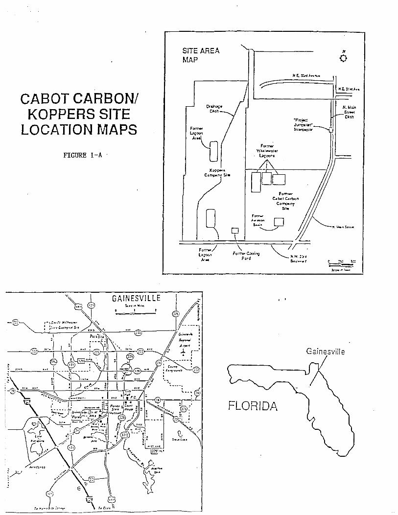
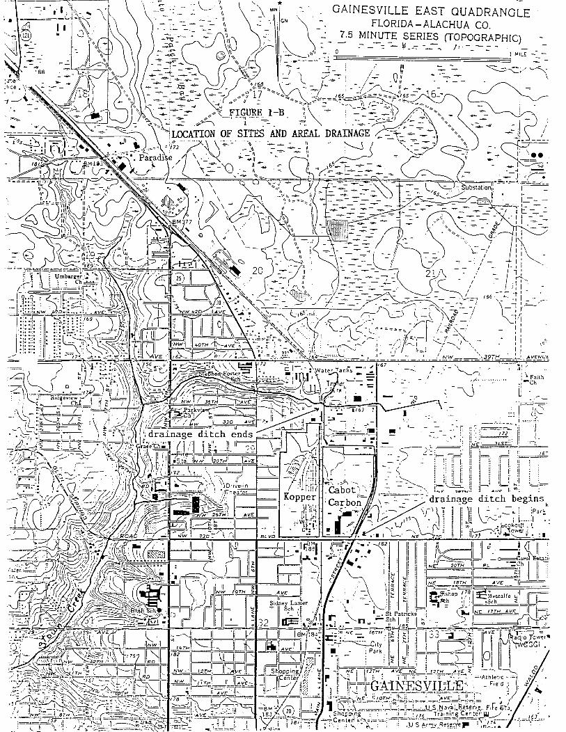
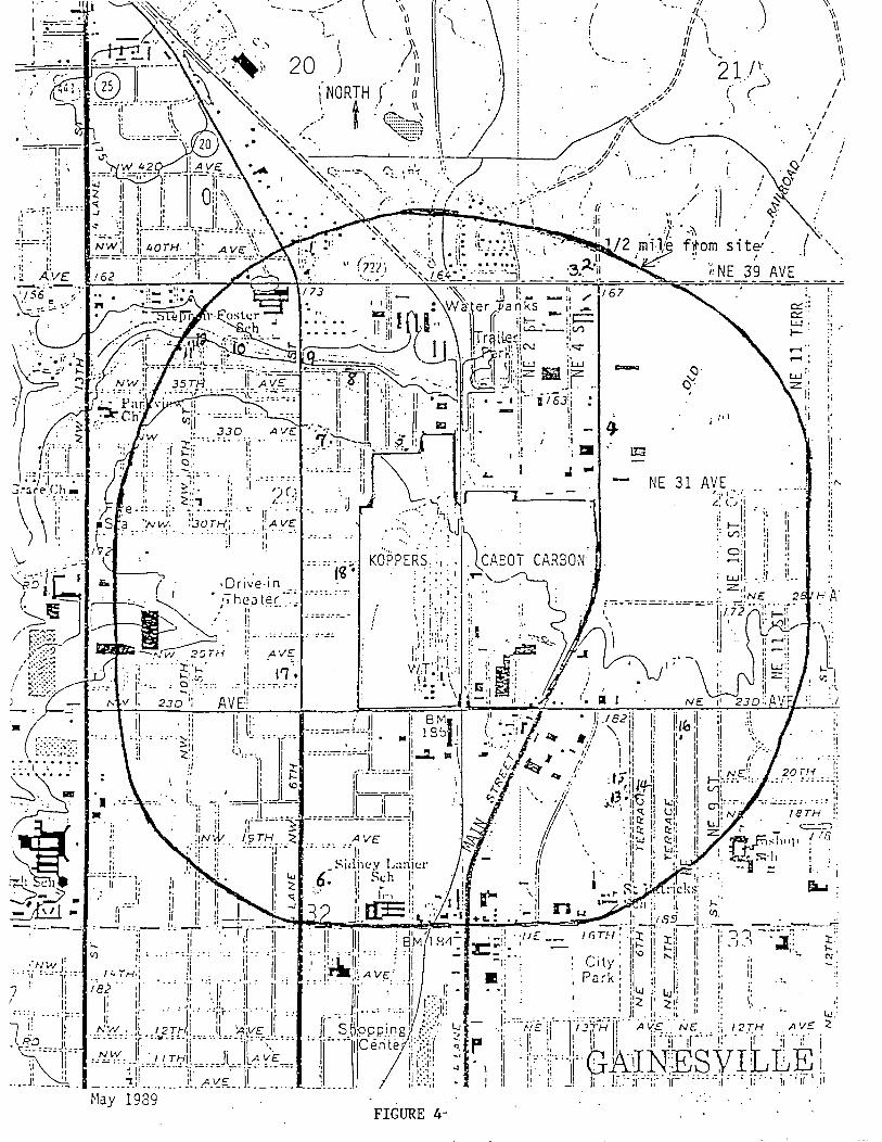
Background The Cabot Carbon/Koppers Superfund site is located near the intersection of Northwest 23rd Avenue and North Main Street in Gainesville, Alachua County, Florida (Figures I-A, I-B). This site consists of three separate entities: the Cabot Carbon land (49 acres in the eastern portion), the Koppers Corporation land (82 acres in the western portion), and a 50-acre undeveloped marsh area in the northeastern portion. The Cabot Carbon land is zoned for commercial use and the Koppers Corporation land is zoned for industrial use. The Cabot site was formerly a pine-stump processing plant. It currently houses retail facilities, including a car dealership and a shopping complex. The Koppers portion of the site is an active wood treatment facility. Residential communities are west and south of the site. The North Main Street drainage ditch forms the eastern boundary. This ditch, along with Springstead Creek, empties into Hogtown Creek. Hogtown Creek flows through the city of Gainesville and terminates at Haile Sink, approximately 14 miles away. There are no Superfund National Priorities List (NPL) sites or Resource Conservation and Recovery Act (RCRA) sites within one-half mile of the site.
Since the early 1960s, periodic environmental monitoring has taken place in the surface water and soils on and surrounding the site. The Florida Department of Environmental Protection (DEP; formerly Department of Environmental RegulationjDER), the U.S. Environmental Protection Agency (EPA), the University of Florida, and private engineering fIrms have found high concentrations of pine tars, naphthalene, PCP, phenols and other aromatics, arsenic, copper, chromium, and oil in soil. They also found phenolic contaminated ground water moving east in the surficial aquifer. In late 1992, DEP found polyaromatic hydrocarbons (PAHs) and tar-like substances called "dense non-aqueous phase liquids" (DNAPLs) five to seven feet thick in a Cabot Carbon property monitoring well. EP A listed this site on the Superfund National Priorities List in 1983. In 1994, a citizen notified DEP that Springstead Creek, two miles downstream from the site, was "oozing" dark-brown to black material, viscous and adhesive, with a very aromatic coal-tar-like odor.
1
We compiled health concerns from documented complaints to the Alachua County Public Health Unit, citizen concern studies perfonned by the Alachua County Department of Growth Management, public meeting notes, newspaper articles, and interviews with local health officials. Nearby residents have complained of strong creosote smells, eye and skin irritation, and respiratory health hazards/effects. One individual alleges his multiple sclerosis is due to toluene exposure while working at an automobile dealership on the Cabot Carbon portion of the site.
The Florida Department of Health and Rehabilitative Services (HRS) Office of Environmental Toxicology wrote a public health assessment report in 1989. The report concluded that the site was a potential health concern through contact with contaminated ground water and surface soil. Florida HRS also wrote a Site Review and Update report in 1993. That report concluded that inhalation of contaminated dust and gases was a likely route of exposure in the past for nearby residents, but that no air quality measurements were taken prior to 1988. This made any reliable estimate of health effects from past inhalation exposures impossible. Private and public drinking water wells were not contaminated, so past exposures from consumption of contaminated ground water did not appear to be a route of exposure. The report recommended reassessment of soil and air data to determine if future health effects from these exposures are likely.
On February 10, 1995, Randy Merchant and Julia Winter, of Florida HRS Office of Environmental Toxicology visited the site. They conducted a windshield survey of the Cabot Carbon portion of the site. They observed the area is mostly paved and contains a shopping complex and automobile dealerships. No signs were posted and no areas were fenced off from public access. North Main Street road construction was still taking place at that time.
On July 28, 1995, Mr. Merchant and Ms. Winter again visited the site and observed the widening of North Main Street was completed and the surficial aquifer ground water interceptor system was in place. Mr. Merchant and Ms. Winter also toured the Koppers portion of the site. They observed a strip of trees and underbrush directly south and west of the site. This green area consists of trees up to 50 feet tall, dense underbrush, and varies from 20 to 50 feet wide. Mr. Merchant and Ms. Winter observed that fencing was not continuous around the site; it appeared that onI y the south portion (facing NE 23rd A venue) and a part of the west portion (up to the residential section) of the Koppers area were fenced. Areas of creosote-contaminated soil have been excavated and/or have grown over with foliage. Few hazardous waste warning signs were posted. Dust control measures for the Koppers site included spraying with water from an on-site storage tank. They observed a series of 13 on-site monitoring wells.
An abandoned treatment building on the site has standing water up to 15 feet deep. Its metal roof and walls are in a high state of disrepair. Although the building is roped off with nylon webbing, it would not prevent entry. We did not notice any evidence of site trespass, but
2
consider this building is a drowning hazard, a fall hazard (should the standing water be extracted), and a general injury hazard from collapse.
Current Status Ground water cleanup has begun on the Cabot portion of the site. Beazer, Inc. is reviewing their remediation plans for the Koppers portion of the site, based on the DNAPLs found in their monitoring wells. The Main Street widening project has been completed and a surficial aquifer groundwater interceptor system is operational.
Environmental Sampling Data Based on past site use, previous data analysis, and health assessments, we consider arsenic, chromium, benzene, and phenol representative contaminants of concern for this consult.
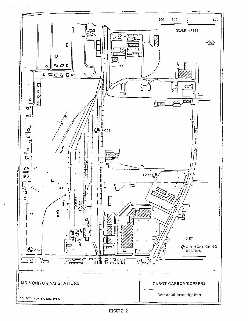
Air Sampling Data In 1988, Hunter/ESE collected respirable-sized airborne particulate matter and vapor at three stations (Figure 2). Each station was equipped with two high-volume samplers to obtain analytical samples for metals and sernivolatiles analysis. Twenty-four hour integrated samples were collected for seven consecutive days (November 30, 1988 to December 7, 1988). Due to mechanical problems, the samplers at Station 2 were not functioning on the first and fourth day and analytical results are not available for those two days (Hunter/ESE 1989).
Data showed measurable levels of arsenic and chromium at all three stations. Hunter/ESE did not test for phenol or benzene.
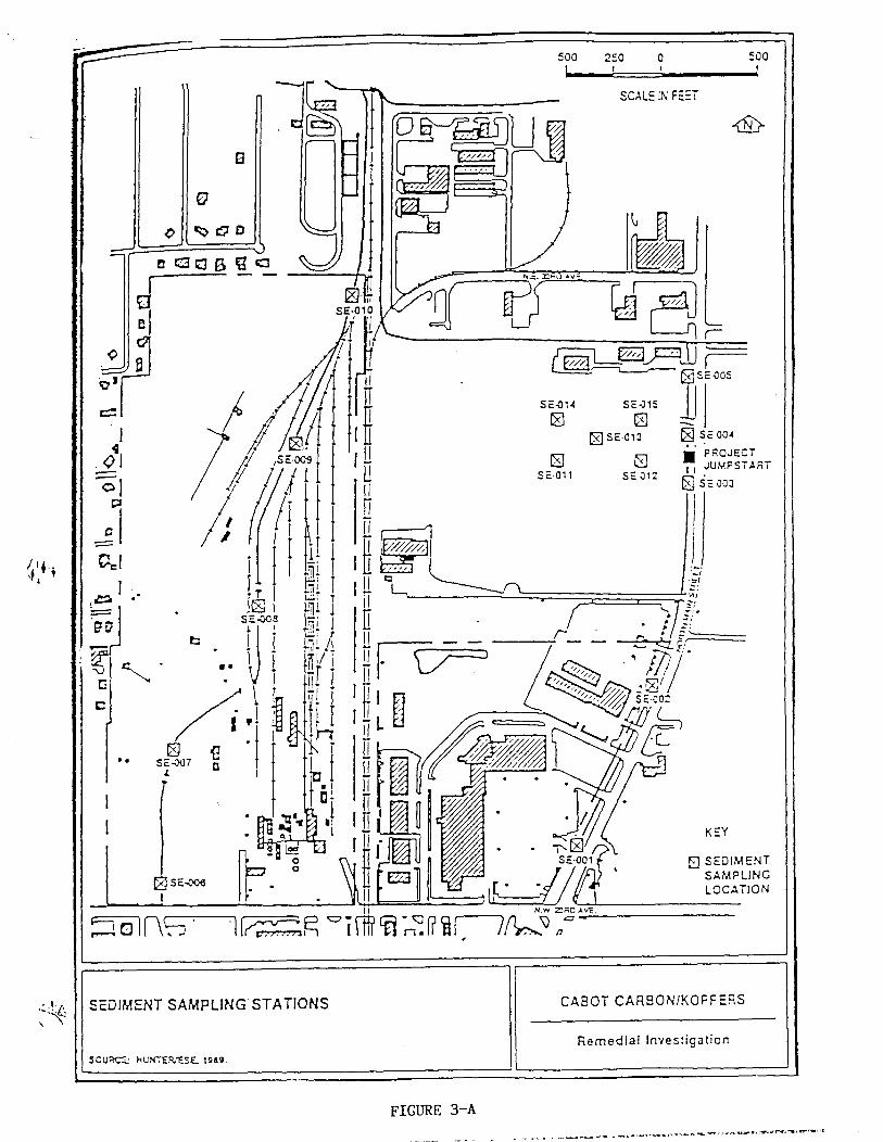
Sediment Sampling Data We compiled and analyzed data from the following studies (Figures 3-A, 3-B): 1) five off-site sediment samples from a 1980 EPA study (EPA 1980 Hazardous Waste Site
Investigation, Phase I), 2) four sediment samples from the Main Street drainage ditch, Hogtown Creek, and the
Koppers site drainage ditch from a 1984 EPA study (EPA 1984 Hazardous Waste Site Investigation, Cabot Carbon/Koppers Companies),
3) seven North Main Street drainage ditch, Hogtown creek, and tributary creek samples from a 1987 IT study (IT Remedial Investigation Report, Volume 2, March 1987),
4) fourteen sediment samples from the North Main Street drainage ditch, the Koppers site ditch, and Hogtown Creek from a 1989 Hunter/ESE study (Remedial Investigation/Risk Assessment at the Cabot Carbon/Koppers Site, Volume 1, September 1989).
5) five sediment samples from Springstead creek, taken in 1994 and 1995 (Quality Analytical Laboratories, Inc lab sheet results, June, 1994 and August, 1995).
6) ten sediment samples from Springstead and Hogtown creek, taken in 1995 (PPB Environmental Laboratories, Inc.; metals results, September, 1995)
3
7) four sediment samples from Springstead and Hogtown creek, taken in 1995 (PPB Environmental Laboratories, Inc; VOC results, September, 1995))
We analyzed spatial clustering and temporal changes in concentrations of arsenic, benzene, chromium, and phenol in the North Main Street ditch and Hogtown Creek sediments. In the NW comer of the Cabot Carbon site and the northeastern comer of the Koppers site, elevated levels of arsenic and chromium were found. We did not consider data from the Koppers site ditch (Kn in Figure 3) because that drainage ditch runs through the center of the site and public access is limited.
Phenol and benzene levels in Springstead Creek sediment were below recommended screening levels. Arsenic and chromium were detected in Springstead Creek samples, but were below levels of health concern.
Ground Water Sampling Data We compared ground water sampling data with EPA and DEP drinking water standards. We used lifetime cancer risk exposure guidelines (CREG) values to evaluate the cancer risk of arsenic and benzene. For chromium and phenol, we evaluated the health risk to children.
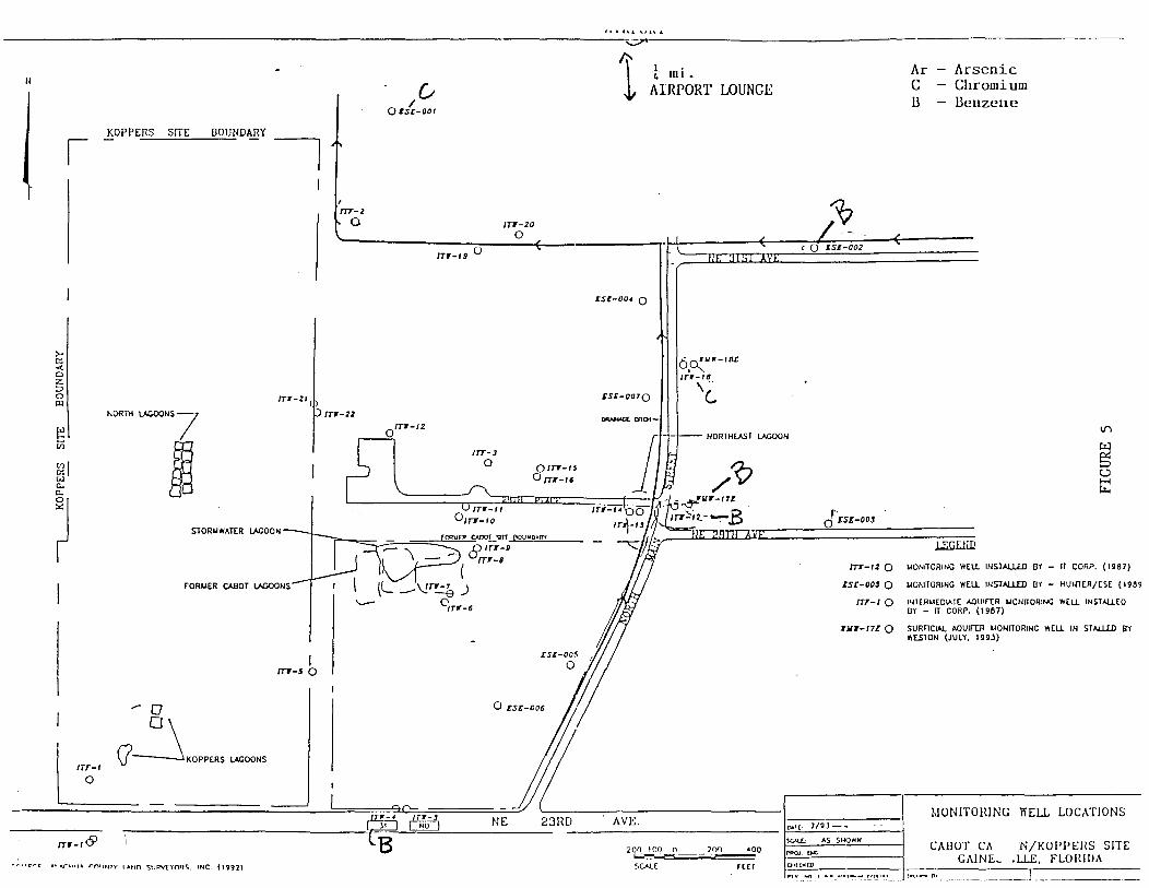
Surficial Aquifer (wells less than 150-200 feet deep): We analyzed data from 22 surficial aquifer wells near the site (Figures 4, 5). Sampling dates range from 1987 through 1995 and many of the wells have multiple-year data. Thirteen are nearby private (homeowner) wells and the remaining nine are nearby off-site monitoring wells. Of the private wells, six are potable (drinking water) wells, five are non-potable (irrigation) wells, and two are of unknown use. (HRS, 1987 - 1994; IT, 1987; ESE, 1989; Weston, June 1992, October, 1992, Jan 1993, April 1993, July 1993, January 1994, January 1995).
Potable wells: Since 1987, the concentrations of arsenic, benzene, chromium, and phenols in nearby drinking water wells have been less than the EPA drinking water standards and DEP ground water guidance concentrations (EPA Office of Water, 1993; Florida DEP, 1994).
Irrigation! Monitoring wells: We compiled data from 17 off-site irrigation and monitoring wells. Most of the wells have been sampled regularly since 1987, allowing for a temporal evaluation of contaminant levels. None of the wells had arsenic levels above the EPA drinking water standards and DEP ground water guidance concentrations. Since 1992, four wells had benzene levels above the EPA drinking water standards and DEP ground water guidance concentrations. Two wells exceeded EPA and D EP standards for chromium.
4
Floridan Aquifer: In the Gainesville area, the Floridan aquifer is approximately 150 to 200 feet below land surface (bls) and is approximately 250 feet thick (EPA, Nov, 1980).
Water quality data for the Floridan Aquifer are limited. Three wells identified as "Floridan Aquifer" wells in a 1987 International Technology (IT) study are only 80 feet deep (into the surficial aquifer) and are not Floridan Aquifer wells. One private irrigation well (heat pump/air conditioner use only) is greater than 150 feet, and could possibly be into the Floridan aquifer. Since 1990, annual sample results for this well show only trace amounts of arsenic, well below the EPA drinking water standard of .05 mg/L (range from 0.0035 mg/L to 0.038 mg/L) (HRS laboratory result data, 1990-1994).
In 1980, EPA evaluated the water quality of the Floridan aquifer at Gainesville's North Well Field two miles northeast (down gradient) of the site. The only organic compound identified during the analysis was acetone. Acetone is a field cleaning agent, and is not site related. Four other Floridan aquifer samples were taken by EPA in the 1980 study. These were the Koppers Company fire protection well, the Modell and Clayton residence private water supply wells and the Kanapaha Sewage Treatment plant near Hailes Sink. All organics tested for were below the detectable limit (EPA Hazardous Waste Site Investigation, Phase I, 1980).
Discussion Since children are generally more susceptible to effects from exposure to environmental contaminants, we used exposure scenarios for children. We assumed exposures were chronic (more than 365 days) and continuous (24-hours a day) when calculating potential health effects from soil and water ingestion. We calculated increased cancer risks from inhalation by assuming daily exposure for 70 years.
Air Koppers has performed breathing zone sampling for worker protection since the late 1970's. Levels of chromium or arsenic have not exceeded Occupational Health and Safety Administration (OSHA) permissible exposure limits. These data were for on-site worker safety, rather than residential exposures, and did not include measurements of the contaminants of concern. We used them in our consideration of off-site exposure only as a sentinel of air quality.
Based on the air quality data from the site periphery for one week in 1988, there was no apparent increased risk of cancer or other illness to residents surrounding the site in 1988. Since there is no air monitoring data from the site periphery on the contaminants of concern before 1988, we cannot evaluate the health risk to nearby residents from breathing the air before 1988. There have been no off-site air quality measurements on the contaminants of concern since 1988.
5
Sediment Arsenic: We used the highest sediment concentration of arsenic (1981 data) to determine possible health effects to a 10 kg child incidentally ingesting 200 mg/day of sediment for more than 365 days (chronic exposure). The highest dose of arsenic was estimated based on a sediment sample collected from the intersection of Hogtown Creek/Koppers drainage ditch in the far northeastern comer of the Koppers portion of the site. Cebrian, et al (1983) showed chronic ingestion of soil containing arsenic at similar levels would result in gastrointestinal irritation, pigmentation changes, and hyperkeratosis. Based on the Cebrian study, we predict that prior to 1982, long term (more than one year) incidental ingestion of sediments on and near the Hogtown Creek/Koppers drainage ditch intersection could have caused stomach irritation and skin color changes in children.
Data from the same area from subsequent years showed a decrease in arsenic levels in the sediment. All other sampling locations, past and present, had levels which would pose no health threat. Based on the decrease in arsenic levels in the sediment, we conclude that there is currently little risk of illness from incidental ingestion of sediments in the Hogtown creek/Koppers ditch intersection. Based on the decreasing trend in arsenic levels, we predict no future health effects from exposure to sediments from the North Main Street drainage ditch and Hogtown Creek.
Arsenic data from Springstead creek indicates sediment is unlikely to cause any illness from incidental ingestion by children or adults, presently or in the future. We cannot determine past health effects from exposure to arsenic in these sediments, since no past data is available.
Chromium: The levels of chromium found in the North Main Street drainage ditch, Springstead Creek, and Hogtown Creek sediment are unlikely to cause any illness from incidental ingestion by children or adults. Based on a decreasing trend in chromium levels, we assume no future health effects from exposure to the sediments in North Main Street and Hogtown Creek. Based on current levels of chromium in Springstead creek, we assume no apparent future health effects from exposure to these sediments.
Other Contaminants of Concern: Since phenol and benzene levels in Hogtown Creek and the North Main Street ditch were below detection limits between 1981 and 1989, we assume there was no health threat to children from these contaminants. The data are inadequate to define any health threats prior to that time.
Based on phenol and benzene levels in Springstead Creek sediment in 1994 and 1995, there is no current or future health threat from incidental ingestion of these sediments. There are inadequate data to determine past exposures/health threats from exposure to phenol or benzene in Springstead Creek sediment before 1994.
Springstead Creek sediment sampling results showed elevated levels of chemicals other than
6
the contaminants of concern in this health consultation. There is umestricted access to Springstead Creek and a tar-like substance is currently visible in the creek. There is currently inadequate data to determine the nature and extent of these other contaminants Springstead Creek.
Ground Water Surficial Aquifer/potable wells: Nearby private drinking water wells, which have been tracked by HRS since 1987, have shown no elevated contaminant of concern levels. These wells are northwest of the site. Groundwater flow in the surficial aquifer is in a northeasterly direction (Clark, et aI, 1964). It does not appear that any contaminants have migrated towards these wells. Because there are no potable wells within 1/2 mile northeast of the site, we do not anticipate future contamination. Arsenic, chromium, benzene, and phenol do not pose any current or future health threat to existing private potable water supplies in the surficial aquifer.
Surficial Aquifer/irrigation and monitoring wells: Arsenic, chromium, and benzene have been found in monitoring and irrigation wells during quarterly monitoring contracted to Weston, Inc (1992 - present quarterly reports). We calculated a maximum exposure dose using the highest levels found. No health effects are likely from lifetime ingestion of chromium at the maximum dose calculated (0.004 mg/kg/day) (USPHS Toxicological Profile for Chromium, 1992). We estimate lifetime ingestion of the maximum calculated dose of benzene (0.0015 mg/kg/day) would result in a low increased risk of cancer (USPHS Toxicological Profile for Benzene, 1992). We estimate lifetime ingestion of the maximum calculated dose of arsenic could affect the skin, liver, kidneys, blood-forming organs, eyes, and cause gastrointestinal disorders, hyperkeratosis and hyperpigmentation (skin color changes), abdominal pain, and hepatomegaly (enlarged liver). We also estimate lifetime exposure to this dose would result in a moderate increased risk of skin cancer (USPHS Toxicological Profile for Arsenic, 1992).
Presently, these irrigation and monitoring wells are not used for human consumption. If those wells are converted to potable wells, the health effects listed above are possible. We strongly advise that these wells remain nonpotable, and that installation/permitting of new potable wells near the northeastern section of the site be restricted. At a minimum, any new potable wells in the northeastern quadrant should be regularly monitored for contaminants of concern.
Floridan Aquifer: Based on the data reviewed, there is no evidence of a public health threat from ingestion of Floridan aquifer water near the site.
Pu blic Access/N otification In 1980, the Alachua County Pollution Control District posted thirteen warning signs along drainage ditches and creeks in the vicinity of the Cabot/Koppers site (memo, July 11, 1980). We observed only one warning sign near the entrance to the Koppers portion of the site during our 1995 site visits. This site is still listed as a Superfund NPL site and falls under
7
state law requiring warning signs.
Creeks off-site and downstream from the site have umestricted access from the public.
Public access is not limited on the Cabot portion of the site because of the commercial development and the presence of a physical barrier (parking lot) to soils. It is impractical and unnecessary, from a public health standpoint, to limit access to that portion of the site. Public access to the Koppers portion of the site is somewhat limited. The site is fenced along the southern border, and along part of the western border. Dense vegetation exists along the western and northern borders of the Koppers site, which will discourage trespassing, but not prevent it. Because this is still an active wood treatment facility, Koppers/Beazer East, Inc should further restrict site access.
Conclusions Is there a health threat to residents from present or future exposures to vapors or dust from the site? 1. Since there is no off-site/periphery air monitoring data before 1988, we cannot evaluate
the past health risks (prior to 1988) to nearby residents. There does not appear to be a health threat from inhalation exposure to arsenic or chromium in 1988. Off-site monitoring has not been performed since then. However, based on current on-site OSHA testing, we do not believe a current health threat exists from exposure to vapors or dust from the site. In addition, on-site dust suppression seems adequate to prevent dust exposures to residents. Therefore, we do not recommend any air monitoring at this time.
Is there a health threat to residents from past, present, or future exposures to sediments in site drainage areas? 2. Children playing in the Hogtown Creek/Koppers drainage ditch area before 1981 may
have experienced gastrointestinal irritation, hyperkeratosis (orange skin), and pigmentation changes from incidental ingestion of arsenic-contaminated sediments.
3. There is no apparent current or future health threat to children from exposure to chemicals of concern in drainage ditches along North Main Street, Hogtown Creek, and the Koppers ditch/Hogtown Creek confluence.
4. There is no apparent current or future threat to children from exposure to chemicals of concern from Springstead Creek sediment. The data are inadequate to determine past health threats from exposure to Springstead Creek sediment.
5. There is inadequate data to determine the nature and extent of contamination from chemicals other than the chemicals of concern addressed in this health consult. There is inadequate data to assess the past, present, or future off-site health threat from exposure to other site-related chemicals in Springstead Creek sediment.
Is there a health threat to residents from present or future exposures to surficial potable wells? From the Floridan Aquifer?
8
6. Consumption of water from nearby existing potable wells is not an apparent past or current health threat. Contaminants of concern do not pose an apparent future health threat to existing potable water supplies in the surficial aquifer.
7. It is unlikely that ingestion of the ground water from the on-site Floridan aquifer monitor well would cause illness. However, more recent data are necessary to fully ascertain any current or future effects on the deep aquifer from this site. Koppers should continue to monitor the on-site Floridan Aquifer well, however, to detect any future contamination of the Floridan Aquifer.
Other Conclusions 8. The standing water in the abandoned creosote treatment building is a drowning hazard for
children who may trespass on the site. 9. The open basement of the abandoned creosote treatment building, if the water was
pumped out, would be a falling hazard to any trespassers on the site. 10. The abandoned creosote treatment building itself poses an injury hazard to any
trespassers, through collapse of the roof or walls. 11. Public access is not adequately limited on the Koppers portion of the site.
HARP The ATSDR Health Activities Recommendations Panel (HARP) usually reviews documents at sites where a health threat exists, where a high level of citizen concern exists, or where the potential for future site activities to affect public health exists. Based on the available data and the current status of the site, this health consult does not warrant a review by the HARP.
Health Hazard Classification Based on the data reviewed, we classify the site as a "Public Health Hazard" due to the physical hazards present on the site. However, the evaluation of chemical hazards at the site result in a "No Apparent Public Health Hazard" classification. Human exposure to contaminated media has occurred in the past, but the exposure was not a levels which are likely to result in health effects.
9
Recommendations
1. Restrict access to the Koppers portion of the site. Post warning signs as required by Florida Statutes 403.704 and 403.7255.
2. Improve and maintain a more effective barrier to trespassing at the abandoned creosote treatment building or eliminate the hazard by pumping out the accumulated water, filling in that area, and removing the remaining structure. These steps should be taken as soon as possible. The urban location of this site greatly increases the likelihood of an accident occurring. The building currently poses an urgent hazard to potential trespassers.
3. Continue to monitor off-site monitoring and irrigation wells northeast of the site. 4. New private potable water supply wells should not be permitted directly
north/northeast of the site if contaminated ground water continues to move in that direction. If any new private wells are permitted in that area, they should be monitored annually for contaminants of concern.
5. If breathing zone sampling for worker safety indicates air quality problems, off-site air quality should be measured for contaminants of concern.
6. Due to unrestricted access, proximity to residences, and the presence of contaminants (other than contaminants of concern) in Springstead Creek, further sampling of Springstead Creek sediment (i.e., the "black goop") should be conducted to assess the nature and extent of contaminants.
Author of the Health Consult Julia M. Winter, M.S. Environmental Toxicology Florida Department of Health and Rehabilitative Services
10
CERTIFICA TI ON
This Cabot/Koppers Health Consultation was prepared by the Florida Department of Health and Rehabilitative Services under a cooperative agreement with the Agency for Toxic Substances and Disease Registry (ATSDR). It is in accordance with approved methodology and procedures existing at the time the health consultation was begun.
finan, M.S. Technical oject Officer
Superfund Site Assessment Branch (SSAB) Division of Health Assessment and Consultation (DHAC)
ATSDR
The Division of Health Assessment and Consultation, ATSDR, has reviewed this health consultation, and concurs with its [mdings.
11
References
Alachua County Pollution Control District. 1980. Memo to DEP dated July 11.
ATSDR. 1989. Health Assessment for Cabot CarbOn/Koppers site, Alachua County, FL. U.S. Public Health Service, Agency for Toxic Substances and Disease Registry, Atlanta, GA.
ATSDR 1992. Public Health Assessment Guidance Manual. U.S. Public Health Service, Agency for Toxic Substances and Disease Registry, Atlanta, GA.
ATSDR 1995. Comparison Value Tables for Drinking Water (Expiring 9/30/95). Atlanta, GA: U.S. Public Health Service, Agency for Toxic Substances and Disease Registry.
Clark, W.E., Musgrove, RH., Menke, e.G, and Cagle, l.R lr. 1964. Water Resources of Alachua, Bradford, Clay and Union Counties, Florida. Florida Geological Survey Report of Investigations, No. 35.
Environmental Protection Agency. 1980. Hazardous Waste Site Investigation, Phase I. Cabot Carbon Site, Gainesville, Florida. November, 1980. U.S. EPA Region IV Surveillance and Analysis Division.
Environmental Protection Agency. 1990. Region IV, Record of Decision.
Environmental Protection Agency. 1984. Hazardous Waste Site Investigation, Cabot Carbon/Koppers Companies, Gainesville, Florida. US EPA Region IV Environmental Services Division. EPA Project # 84-004.
Environmental Protection Agency. 1990. Region IV Report for Waste Sampling Investigation, Soils, May 30, 1990. Memo dated October 5.
Environmental Protection Agency Office of Water. 1993. Drinking Water Regulations and Health Advisories, May.
FHRS. 1987. Water Systems Environmental Chemistry Analysis Report, Jacksonville, FL.
FHRS. 1988. Water System Hydrocarbon Sample Report, Jacksonville, FL.
FHRS. 1989. Water Systems Environmental Chemistry Analysis Report, Jacksonville, FL.
FHRS. 1990. Water Systems Environmental Chemistry Analysis Report, Jacksonville, FL.
FHRS. 1991. Water Systems Environmental Chemistry Analysis Report, Jacksonville, FL.
FHRS. 1992. Water Systems Environmental Chemistry Analysis Report, Jacksonville, FL.
FHRS. 1993. Water Systems Environmental Chemistry Analysis Report, Jacksonville, FL.
12
FHRS. 1993. Site Review and Update, Cabot Carbon/Koppers site, Alachua County, FL Florida Department of Health and Rehabilitative Services, Tallahassee, FL, under cooperative agreement with the Agency for Toxic Substances and Disease Registry, Atlanta, GA.
FHRS. 1994. Water Systems Environmental Chemistry Analysis Report, Jacksonville, FL.
FHRS. 1995. Site Visit Notes (July 28). Florida Department of Health and Rehabilitative Services, Tallahassee, FL.
Florida Department of Environmental Protection. 1994. Ground Water Guidance Concentrations, June.
Florida Department of Environmental Regulation. 1986. Bureau of Operations. Assessment of Management Alternatives for North Main Street Muck, Gainesville, Florida.
Hunter/ESE, Inc. 1989. Remedial Investigation/Risk Assessment at the Cabot Carbon/Koppers Site, Gainesville, Florida. Volume 1: Remedial Investigation.
IT Corporation. 1987. Remedial Investigation Report Volume 1. Florida Department of Environmental Regulation.
IT Corporation. 1987. Remedial Investigation Report Volume 2. Florida Department of Environmental Regulation.
PPB Environmental Laboratories, Inc. 1995. Analytical data for Alachua County DEP: Springstead Creek, metals. September 19.
PPB Environmental Laboratories, Inc. 1995. Analytical data for Alachua County DEP: Springstead Creek, VOCs. September 19.
Phone conversation with Pegeen Hamahan, Alachua County DEP. November 14, 1995.
Phone conversation with Mike Juba, Koppers, Inc. September 26, 1995.
Quality Analytical Laboratories, Inc. 1994. Analytical Data for Alachua County DEP: Springstead Creek. June 16.
Quality Analytical Laboratories, Inc. 1995. Analytical data for Alachua County DEP: Springstead Creek. August 29.
U.S. Department of Health & Human Services. 1992. Toxicological Profile for Chromium Update. U.S. Public Health Service, Agency for Toxic Substances and Disease Registry.
13
U.S. Department of Health & Human Services. 1992. Toxicological Profile for Arsenic Update. U.S. Public Health Service, Agency for Toxic Substances and Disease Registry.
U.S. Department of Health & Human Services. 1992. Toxicological Profile for Benzene Update. U.S. Public Health Service, Agency for Toxic Substances and Disease Registry.
Weston, RF., Inc. 1992. Remedial Design Work Plan.
Weston, RF., Inc. 1993. Results of Quarterly Groundwater Sampling, January.
Weston, RF., Inc. 1993. Results of Quarterly Groundwater Sampling, April.
Weston, RF., Inc. 1993. Results of Quarterly Groundwater Sampling, July.
Weston, RF., Inc. 1993. 90% Remedial Design Report, 90% Design Specifications Report/Appendix A; Summary of Shallow Aquifer Analytical Data 1987-1993.
Weston, RF., Inc. 1994. Results of Quarterly Groundwater Sampling, January.
Weston, RF., Inc. 1994. Results of Quarterly Groundwater Sampling, April.