19
Heritage Precincts Report 2004 Prepared for The City of Whitehorse By Samantha Westbrooke Jenny Dalrymple
Heritage Precincts Report 2004 Prepared for The City of Whitehorse By Samantha Westbrooke Jenny Dalrymple
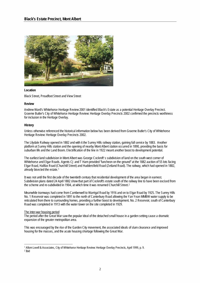
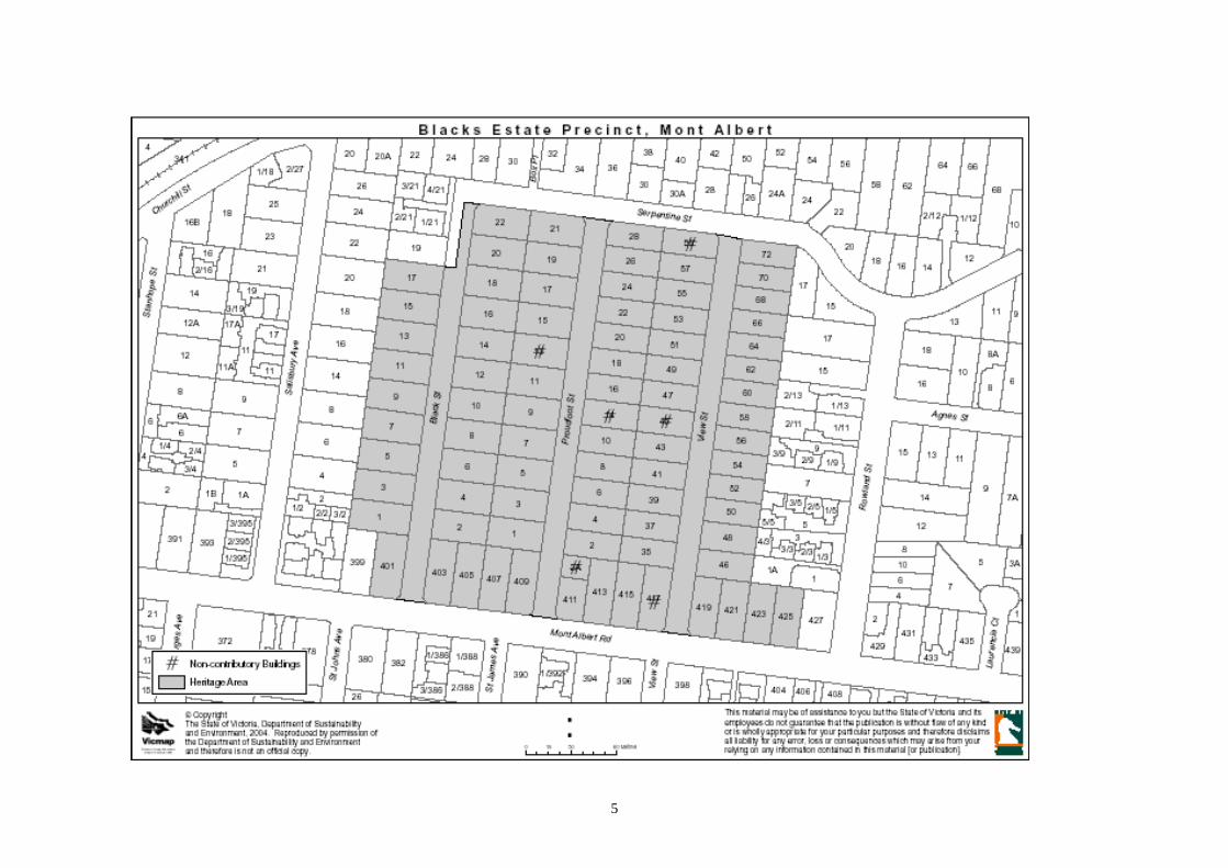
Black’s Estate Precinct, Mont Albert
Location Black Street, Proudfoot Street and View Street Review Andrew Ward’s Whitehorse Heritage Review 2001 identified Black’s Estate as a potential Heritage Overlay Precinct. Graeme Butler’s City of Whitehorse Heritage Review: Heritage Overlay Precincts 2002 confirmed the precincts worthiness for inclusion in the Heritage Overlay. History Unless otherwise referenced the historical information below has been derived from Graeme Butler’s City of Whitehorse Heritage Review: Heritage Overlay Precincts 2002. The Lilydale Railway opened in 1882 and with it the Surrey Hills railway station, gaining full service by 1883. Another platform at Surrey Hills station and the opening of nearby Mont Albert station occurred in 1890, providing the basis for suburban life and the Land Boom. Electrification of the line in 1922 meant another boost to development potential. The earliest land subdivision in Mont Albert was George Cockroft' s subdivision of land on the south west corner of Whitehorse and Elgar Roads. Agents CJ and T Ham provided "luncheon on the ground" at the 1882 auction of 55 lots facing Elgar Road, Halifax Road (Churchill Street) and Huddersfield Road (Zetland Road). The railway, which had opened in 1882, already bisected the estate.1 It was not until the first decade of the twentieth century that residential development of the area began in earnest. Subdivision plans dated 24 April 1882 show that part of Cockroft's estate south of the railway line to have been excised from the scheme and re-subdivided in 1904, at which time it was renamed Churchill Street.2 Meanwhile tramways had come from Camberwell to Warrigal Road by 1916 and on to Elgar Road by 1925. The Surrey Hills No. 1 Reservoir was completed in 1891 to the north of Canterbury Road allowing the Yan Yean MMBW water supply to be reticulated from there to surrounding homes, providing a further boost to development. No. 2 Reservoir, south of Canterbury Road was completed in 1913 with the water tower on the site completed in 1929. The inter-war housing period The period after the Great War saw the popular ideal of the detached small house in a garden setting cause a dramatic expansion of the greater metropolitan area. This was encouraged by the rise of the Garden City movement, the associated ideals of slum clearance and improved housing for the masses, and the acute housing shortage following the Great War.
1 Allom Lovell & Associates, City of Whitehorse Heritaqe Review: Heritage Overlay Precincts, April 1999, p. 9. 2 Ibid
2
Black’s Estate Precinct, Mont Albert
The extension of train services and electrification and expansion of tramlines enabled travel over greater distances to and from work. Ownership of a car also became increasingly common amongst the middle class. While the affluent continued to build larger, often architect designed examples of the favoured styles in areas such as Toorak, South Yarra, Malvern, Kew and Balwyn, public transport and lower land prices encouraged the working classes to move to the developing outer suburbs such as Surrey Hills, Mont Albert and Box Hill.3
The subdivision In the 1890s Robert Black established a dairy farm on property north of Mont Albert Road and at the rear of houses facing Elgar Road and Salisbury Street. He subdivided in 1923 forming Black Street, View Street and Proudfoot Street.4 It appears from the era and style of housing in this area that many of the blocks were purchased at this time and developed within a short period of time. Origin of street names in the precinct Black Street was named after Robert Black who subdivided the land, View Street was the continuation of an existing street and it is believed that Proudfoot Street was named after the Black family solicitor. Proudfoot was a Councillor from 1911 – 31, serving as Shire President from 1916 – 1917 and 1924 – 1926 and was the first Mayor when the western part of the Shire became the Borough of Box Hill in 1926.5
Description Black’s Estate containing View Street, Black Street and Proudfoot Streets consists of a large collection of inter war houses dating from the 1920s and 30s. The precinct demonstrates the range of styles from this era including the Bungalow, Tudor (or English Cottage) Revival, Spanish Mission, Georgian Revival and Streamline Moderne. Some of the houses are a combination of one or more of the styles. The residences are substantially constructed of masonry or have masonry featured in the front facade. There are a few 1940s masonry dwellings amongst the 1920s and 30s houses but these are also similar in form, materials and setback, contributing to the consistent nature of the precinct. Below is a list of the common characteristics of houses in the precinct:
• 1920s, 1930s and 40s buildings • Substantially single storey • Similar setbacks from the street • Driveways to one side of the house leading to a garage near or at the rear boundary, with single crossover • Commonly masonry construction • Render over the masonry is common • Hipped roofs with terracotta or other ceramic tiles • Defined entry porches • Different colour brick used for decorative detailing • Similar scale (height) and double fronted, detached • Dominant front porches usually in masonry • Timber framed windows, typically making up less than 50% of any associated wall surface • Dominant chimneys, suited to the particular style of house, and used as a decorative element • Early, low pier and panel masonry (face brick and/or rendered finish), some reconstructed timber framed wire
fabric fences for the Californian Bungalow style houses, and originally some simple low picket fences
3 Raworth, Bryce, Our Inter-War Houses, How to Recognise, Restore and Extend Houses of the 1920s and 1930s, The National Trust of Australia (Victoria), 1991, p9. 4 Williams. Charles F. The Origins of Box Hill Street Names, City of Box Hill, April 1985, p. 14. 5 Ibid
3
Black’s Estate Precinct, Mont Albert
Statement of Significance What is significant? The Black’s Estate heritage precinct, comprising interwar and 1940s properties with a frontage to Black, Proudfoot and View Streets, Mont Albert and including the houses, other buildings, elements, fences and fabric remaining from those periods. How is it significant? The Black’s Estate heritage precinct is of local historic and aesthetic significance to the City of Whitehorse. Why is it significant? The Black’s Estate heritage precinct is of aesthetic and historical significance to the City of Whitehorse as it contains the best and most intact collection of inter-war and 1940s substantially masonry buildings covering a number of styles, but retaining a consistency in materials, scale, setback and detailing (Criterion A4 & Criterion E). The Black’s Estate heritage precinct is rare in the Whitehorse area as an estate that was subdivided and substantially developed in the 1920s and 30s. While there are many examples of these housing types throughout the municipality, they are generally scattered. Often these types of buildings are infill in earlier subdivisions or were constructed in a 1920s subdivision that only developed partially in the 1920s and 30s and then developed after the war (Criterion A4). The Black’s Estate heritage precinct has aesthetic significance as it contains some excellent examples of 1920s and 30s housing in the range of styles prevalent at the time including Bungalow, Tudor (or English Cottage) Revival, Spanish Mission, Georgian Revival and Streamline Moderne. Of particular note are elements such as masonry porches, distinctive chimneys, curved walls and decorative brickwork (Criterion E).
4
5
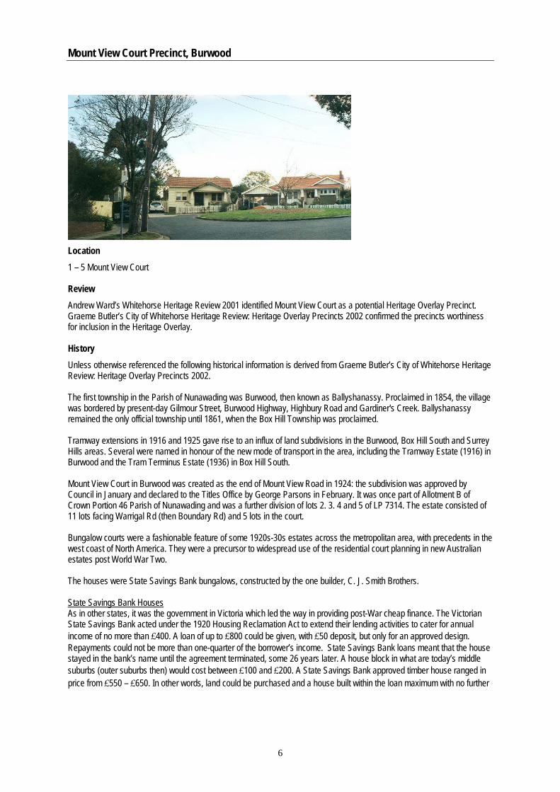
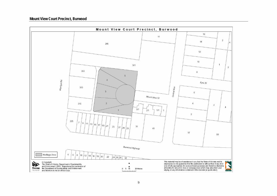
Mount View Court Precinct, Burwood
Location 1 – 5 Mount View Court Review Andrew Ward’s Whitehorse Heritage Review 2001 identified Mount View Court as a potential Heritage Overlay Precinct. Graeme Butler’s City of Whitehorse Heritage Review: Heritage Overlay Precincts 2002 confirmed the precincts worthiness for inclusion in the Heritage Overlay. History Unless otherwise referenced the following historical information is derived from Graeme Butler’s City of Whitehorse Heritage Review: Heritage Overlay Precincts 2002. The first township in the Parish of Nunawading was Burwood, then known as Ballyshanassy. Proclaimed in 1854, the village was bordered by present-day Gilmour Street, Burwood Highway, Highbury Road and Gardiner's Creek. Ballyshanassy remained the only official township until 1861, when the Box Hill Township was proclaimed. Tramway extensions in 1916 and 1925 gave rise to an influx of land subdivisions in the Burwood, Box Hill South and Surrey Hills areas. Several were named in honour of the new mode of transport in the area, including the Tramway Estate (1916) in Burwood and the Tram Terminus Estate (1936) in Box Hill South. Mount View Court in Burwood was created as the end of Mount View Road in 1924: the subdivision was approved by Council in January and declared to the Titles Office by George Parsons in February. It was once part of Allotment B of Crown Portion 46 Parish of Nunawading and was a further division of lots 2. 3. 4 and 5 of LP 7314. The estate consisted of 11 lots facing Warrigal Rd (then Boundary Rd) and 5 lots in the court. Bungalow courts were a fashionable feature of some 1920s-30s estates across the metropolitan area, with precedents in the west coast of North America. They were a precursor to widespread use of the residential court planning in new Australian estates post World War Two. The houses were State Savings Bank bungalows, constructed by the one builder, C. J. Smith Brothers. State Savings Bank Houses As in other states, it was the government in Victoria which led the way in providing post-War cheap finance. The Victorian State Savings Bank acted under the 1920 Housing Reclamation Act to extend their lending activities to cater for annual income of no more than £400. A loan of up to £800 could be given, with £50 deposit, but only for an approved design. Repayments could not be more than one-quarter of the borrower’s income. State Savings Bank loans meant that the house stayed in the bank’s name until the agreement terminated, some 26 years later. A house block in what are today’s middle suburbs (outer suburbs then) would cost between £100 and £200. A State Savings Bank approved timber house ranged in price from £550 – £650. In other words, land could be purchased and a house built within the loan maximum with no further
6
Mount View Court Precinct, Burwood
capital needed, except as an income. Architect A. Burridge Leith created around fifty State Savings Bank designs in Victoria, initially mostly of timber and generally of five main rooms. A sleep-out porch or third bedroom was optional.6
A catalogue of houses containing the range of designs was provided by the State Bank, from which the owner could select the design of their house. As a result there are many California Bungalows across Victoria, which have similar forms, materials and detailing. The summary of specifications from the 1927 State Savings Bank Catalogue gives further description of the material, fittings and fixtures used in the houses. Floor plans and elevations for House types No. 9 and 13 are also attached to this report. Type No. 9 is very similar to No. 4 in Mount View Court and Type No. 13 is very similar No. 2 in Mount View Court. The houses constructed in Mount View Court Original owners of the five properties in Mount View Court and the years they moved into the property are listed below7: 1 Mount View Court, Weber, 1928 2 Mount View Court, Malloch, 1927/28 3 Mount View Court, Waters, 1927 4 Mount View Court, Waters, 1927 5 Mount View Court, Lee, 1926 Description The five residences in Mount View Court are located around a central circular green. The residences are all of weatherboard construction and designed in the California Bungalow style. They are all double fronted with central front doors and front porches. The posts to the porches have brick bases, with 1, 2, 3 & 5 having tapered rendered upper sections while No. 4 has twin posts above the brick base. The roofs consist of a main gable and a smaller gable for a protruding front room or porch. Four of the houses have the main roof form parallel to the frontage and No. 1 Mount View Court has the main gable perpendicular to the front of the house. The roofs are clad in terracotta tiles. Windows are timber framed and double hung and three of the houses have bay windows to their front rooms. The houses at 2, 3 and 4 have side driveways and the houses at 1 and 5 have driveways in the front set back. No 1 has a tall picket fence, 2 and 3 have low picket fences (most likely original), No. 4 does not have a fence and No. 5 has a hairpin wire fence. Similar forms, materials and detailing, unify the houses but each house is subtly different. All houses are substantially intact in the front elevation and forms. Varying extents of rear additions and alterations have occurred to all of the houses. Below is a description of the house (interior) given by a former resident of 5 Mount View Court:
• The house had double front doors with leadlight highlights. • Originally there were two bedrooms, Kitchen, Lounge, Dining Room and Laundry. A sleep-out was built on later. • The toilet was at the back gate until the sewer was connected and then it was moved to near the laundry. • The laundry had a wood copper and later it had gas hot water. • Corner wood fireplaces in lounge and dining room with blue tiles and surround with metal trim and timber
mantelpieces. • Exterior paint colours: Walls cream, windows and doors dark green. Paint brand: Rickshaw Paint. • Picture rails and doors inside dark stained wood. • There were double doors from dining room to lounge room and from hallway to lounge room. • Linoleum floor coverings • Wood stove in kitchen and also a small gas cooker.
6 Butler, Graeme, The Californian Bungalow in Australia, Thomas C. Lothian Pty Ltd, Melbourne, 1992. 7 Pers. Comm. former resident of 5 Mount View Court.
7
Mount View Court Precinct, Burwood
Statement of Significance What is significant? The Mount View Court heritage precinct, comprising the court and central green and the properties with a frontage to Mount View Court and including the California Bungalow style houses and other buildings, fences, elements and fabric relating to this style and period. How is it significant? The Mount View Court heritage precinct is of local historic and aesthetic significance to the City of Whitehorse. Why is it significant? The Mount View Court Residential Precinct is of historical significance to the City of Whitehorse as a good expression of the major growth in housing in Burwood during the immediate post World War One era, as expressed by the Californian Bungalow style housing which was common in that period (Criterion A4 & Criterion E). The precinct is of aesthetic importance for its unity and intactness. All the houses in the court are similar in form, style, detailing and materials and are State Savings Bank design homes, constructed by the one builder, C. J. Smith Brothers (Criterion E). The Court is an excellent example of the movement by banks across the nation to support homebuyers in providing affordable new house options during Australia’s depression years (Criterion B2). Mount View Court heritage precinct is also of aesthetic and historical significance for its distinctive Bungalow Court form around a central circular green which was a precursor to the cul-de-sac planning widely used in Australia after World War Two (Criterion A4 & E).
8
Mount View Court Precinct, Burwood
9
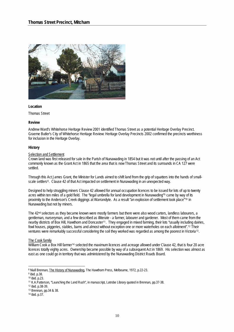
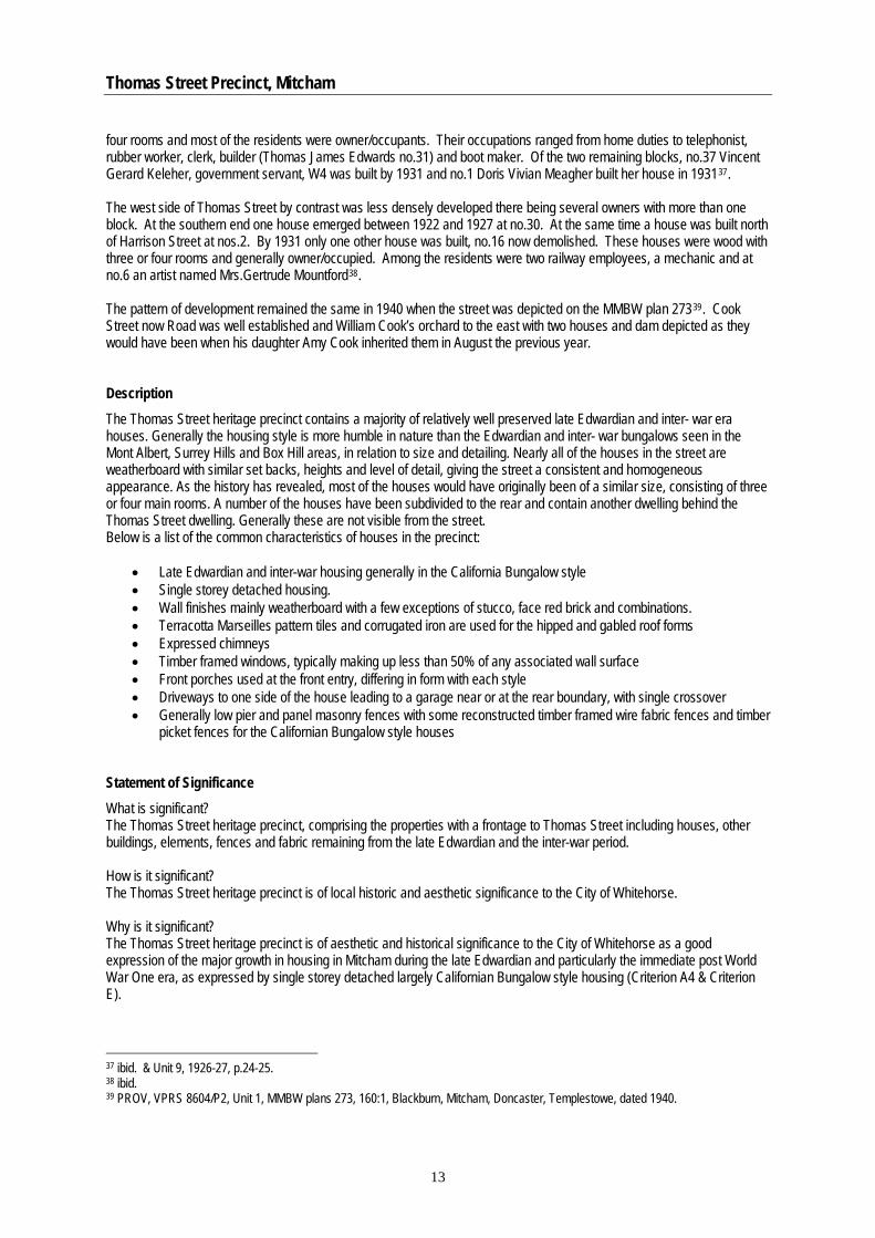
Thomas Street Precinct, Mitcham
Location Thomas Street Review Andrew Ward’s Whitehorse Heritage Review 2001 identified Thomas Street as a potential Heritage Overlay Precinct. Graeme Butler’s City of Whitehorse Heritage Review: Heritage Overlay Precincts 2002 confirmed the precincts worthiness for inclusion in the Heritage Overlay. History Selection and Settlement Crown land was first released for sale in the Parish of Nunawading in 1854 but it was not until after the passing of an Act commonly known as the Grant Act in 1865 that the area that is now Thomas Street and its surrounds in CA 127 were settled. Through this Act James Grant, the Minister for Lands aimed to shift land from the grip of squatters into the hands of small-scale settlers8. Clause 42 of that Act impacted on settlement in Nunawading in an unexpected way. Designed to help struggling miners Clause 42 allowed for annual occupation licences to be issued for lots of up to twenty acres within ten miles of a gold field. The “legal umbrella for land development in Nunawading”9 came by way of its proximity to the Anderson’s Creek diggings at Warrandyte. As a result “an explosion of settlement took place”10 in Nunawading but not by miners. The 42nd selectors as they became known were mostly farmers but there were also wood carters, landless labourers, a gentleman, nurseryman, and a few described as illiterate - a farmer, labourer and gardener. Most of them came from the nearby districts of Box Hill, Hawthorn and Doncaster11. They engaged in mixed farming, their lots “usually including dairies, fowl houses, piggeries, stables, barns and almost without exception one or more waterholes on each allotment”.12 Their ventures were remarkably successful considering the soil they worked was regarded as among the poorest in Victoria13. The Cook family William Cook a Box Hill farmer14 selected the maximum licences and acreage allowed under Clause 42, that is four 20 acre licences totally eighty acres. Ownership became possible by way of a subsequent Act in 1869. His selection was almost as east as one could go in territory that was administered by the Nunawading District Roads Board.
8 Niall Brennan, The History of Nunawading, The Hawthorn Press, Melbourne, 1972, p.22-23. 9 ibid. p.38. 10 ibid. p.23. 11 K.A.Patterson, “Launching the Land Rush”, in manuscript, Latrobe Library quoted in Brennan, pp.37-38. 12 ibid. p.38-39. 13 Brennan, pp.34 & 38. 14 ibid. p.37.
10
Thomas Street Precinct, Mitcham
As CA 127A his land had frontage to the north side of Whitehorse Road and sloped down towards Deep Creek. His immediate neighbours included August Schwerkolt and fellow 42 selectors Frank Ainger and Philip Cummins. His licence to this land was first recorded in the District Roads Board Book of April 1868 as owner/occupant at “Deep Creek, 80 acres of land, NAV 11 pounds”15. At the time he retained a house and 70 acres of land in Whitehorse Road which he had owned since 1863 and possibly earlier. Described generally as a farmer there are references to Cook and family which indicate quarrying activities16. Roads Board assessments tracked ownership from William to Thomas Cook in 1870 and from Thomas to Mrs.Cook in 187117 when payments were completed and Crown grants issued, in this case transferred18. A.Cook appears on Parish plans as grantee 23 May 187119 this being Amee Cook, farmer with house and 70 acres on Whitehorse Road and 80 acres of land, Deep Creek20. Amee Cook’s name was replaced in the Rate Books by Thomas, William and John Joseph Cook by 1885. Thomas owned a “House & 68¾ acres land Blackburne” NAV 75 pounds which was probably the original family farm. This farm at Mitcham passed to William and John each having 40 acres of land with a house21. They were all farmers. By 1888 Thomas Cook no longer occupied the family property however the Mitcham farms remained in the hands of William and John Cook who by then were described as gardeners22. The 1880s brought new activity to Mitcham with the building of the railway line to Ringwood in 1882 and the emergence of brickworks. William Cook seemed to diversify during this period building two houses on Whitehorse Road which he let to William Batty, brick worker and John McLeod, labourer. This was the height of the land boom and opportunists subdivided where they could so that even in this “outlying suburb”23 the auctioneer’s hammer could be heard. Close by on the north side of Whitehorse Road the Mitcham Township Estate and the Mitcham Estate wooed would be settlers and the Blackburn and Tunstall Property Company spread its claws north and south of the railway line24. By 1892 the property CA 127 of the 42 selector Frank Ainger was in the hands of the Imperial Banking Company25. There continued however a rural aspect to the township with many small holdings like Cooks’ surviving. Rate Books indicate that at this time William Cook was absent from his property and that John Cook was engaged in carting26. William Cook returned by 1900 and “settled on his orchard …where he specialized in cherries to such an extent that he became known as the ‘Cherry King’”. He continued with this occupation until his death in 1939 Cherry Court recalling the work a “bluff, hearty man of extreme good nature…”27 with links to Mitcham’s early days. John Cook was not recorded as being in the district in 190028 so activity associated with his farm at that time is unknown. His western portion of the original selection where Thomas Street runs was in the hands of his executors around the out break of war in 191429. Thomas Cook now a Box Hill resident was his beneficiary but the property soon transferred to
15 BHHS, Assessment of the District Roads Board, 1868, assessment no.25. 16 Julia Morant & O.S.Green, Box Hill Sketchbook, Rigby Ltd, Adelaide, 1978, p.12 ‘…Thomas Cook, a member of the family which owned a Mitcham quarry…’ and Brennan, p.95 ‘Cook’s quarry at Mitcham…belong to an early period’. Brennan’s reference is embedded in discussion on clay quarries and small one-man establishments. 17 BHHS, Assessment of the District Roads Board, 1870, assessment no.30 & 1871, assessment no.30. 18 Patterson in Brennan, p.38. 19 Box Hill Historical Society Inc. (BHHS), plan Parish of Nunawading, County of Bourke, nd. 20 BHHS, Shire of Nunawading Rate Book, 1875, North Riding, assessment nos.29 & 30. 21 ibid. 1885, assessment nos.33, 34, 36. Also recorded - John Cook, house & 23 acres Mitcham CA 127C which was subdivided by 1892 as the Mitcham Township Estate ( between Mitcham/Doncaster East Roads) 22 ibid. 1888, assessment no.90-93. 23 Brennan, p.94. 24 Copy of map, “Parish of Nunawading” dated 26 November 1892 in Brennan, pp.62-63. 25 ibid. 26 Rate Book 1890, North Riding, p.47. 27 ibid. 28 BHHS, Sands and McDougall Directory 1900, p.381. 29 Rate Book 1914, Mitcham Riding, p.30.
11
Thomas Street Precinct, Mitcham
Thomas’ wife Rachael Ann Cook. At the time there was a house on 35 acres leased to Richard Callahan a blacksmith and a house on 5 acres leased to William Charles Draper a green grocer30. Mitcham in 1914 At the time of Cook’s subdivision the 1914 Rate Book for Mitcham Riding31 revealed the main concentration of population in Mitcham was spread along Whitehorse and Mitcham Roads, where they intersected and clustered towards the train station. It was not a densely populated town. Housing estates created in the previous century such as Mitcham Estate Part B and the Mitcham Township Estate still had oodles of undeveloped lots. Section A of the former which created 87 lots in the Edward and Albert Streets area had given rise to 17 houses and the latter centred round McDowall Street with 163 lots had realised 16 houses. In an area renown for its clay based industry almost without exception houses were timber although a handful of wattle and daub places survived, a couple of huts and a cement house. A few brick places existed including public buildings such as the State School in Mitcham Road and a hall in Britannia Street. There was also a blacksmithy of iron. New places were built in 1914 including 2 wood shops in Railway Reserve and a brick office owned by Patrick Joseph Markham. The Municipal Directory described Mitcham as a “Growing township…Residential and fruit growing…Population 1093” in 1915. This was about one third the population of Box Hill which was described as a “Flourishing suburban township”. Nevertheless it was lit by electricity and had much sought after essential services – “a post, telegraph, telephone and money-order office, State school, three churches, public hall, police station, two hotels, tile works, cool stores for fruit32. Thomas Street The southern section of John Cook’s farm was subdivided in August 1914 creating Thomas Street and Cook Road33. Amendments made to the plan included the termination of the Harrison Street extension at Thomas Street instead of Cook Road. The subdivision of 78 lots appeared in the main body of the Rate Books in January 191634 with most blocks measuring 50 by about 190 feet. At the time the entire Estate was owned by Rachael Cook with just two houses these being the old farm houses on lots 1 to 3 in Whitehorse Road now nos.583-587 since removed and on lot 51 in Cook Road. These places were let to Mrs.Featherstone and John Draper respectively. The Estate sold slowly at first however the elevated site would have presented a pretty picture especially in spring with William Cook’s cherry orchard in blossom and the Dandenongs in the background. The first two houses emerged in Thomas Street in 1918 on the west side overlooking this vista. On lots 5 and 6 now no.32 William White of Ivanhoe built a wood house with 3 rooms which he sold to one Phillips in 1920. By 1930 it was owned and occupied by John McCallum “gentleman” and was extended to 5 rooms of “W/FC” possibly wood and fibro cement. On lot 9 Norman Valentine Hill, joiner also built a wood house with 3 rooms which in 1922 he sold to Clement Victor Rogers, a dental mechanic. Rogers subsequently bought the adjoining lots 7-11 giving him the blocks between no.32 and Harrison Street. This house at no.26 has since been removed35. Land sales improved dramatically after the War and with the new decade came further development. By 1922 on the west side there were houses at no.6 Frederick Witt, mechanic, W3 and no.10 Leslie Cooper, builder, W4. On the east there were houses at no.5 Russell Prescott, no.7 Albert Grundy, driver/builder, W4 unfinished, no.21 William Charles Briggs, carpenter, W5 and no.33 Thomas James Edwards, tile worker, W4 giving a total of 8 houses in the street36. From that time on development along east side was steady with all lots being built on by the early 1930s. Between 1922 and 1927 houses were built at nos.3, 9, 11, 13, 15, 17, 23, 25, 27, 29, 31, 35. All of these houses were wood with three or 30 ibid. 31 Rate Book 1914, Mitcham Riding, passim. 32 BHHS, Victorian Municipal Directory, 50th Edition, 1915. 33 WHS, ND 834 (part), Lodge Plan no.6626 declared 8 August 1914. 34 Rate Book 1916, Mitcham Riding, pp.30-34. 35 BHHS Rate Books, Mitcham Riding, 1918, pp.40-41 & 1920, pp.41-41. Also PROV, VPRS 8113/P1, Rate Books Shire of Nunawading Mitcham Riding, Unit 3, 1921-22, p.15ff & Shire of Blackburn & Mitcham, Unit 20, 1930-31, pp.102-103. 36 PROV, VPRS 8113/P1, Rate Books Shire of Nunawading Mitcham Riding, Unit 3, 1921-22, p.15ff.
12
Thomas Street Precinct, Mitcham
four rooms and most of the residents were owner/occupants. Their occupations ranged from home duties to telephonist, rubber worker, clerk, builder (Thomas James Edwards no.31) and boot maker. Of the two remaining blocks, no.37 Vincent Gerard Keleher, government servant, W4 was built by 1931 and no.1 Doris Vivian Meagher built her house in 193137. The west side of Thomas Street by contrast was less densely developed there being several owners with more than one block. At the southern end one house emerged between 1922 and 1927 at no.30. At the same time a house was built north of Harrison Street at nos.2. By 1931 only one other house was built, no.16 now demolished. These houses were wood with three or four rooms and generally owner/occupied. Among the residents were two railway employees, a mechanic and at no.6 an artist named Mrs.Gertrude Mountford38. The pattern of development remained the same in 1940 when the street was depicted on the MMBW plan 27339. Cook Street now Road was well established and William Cook’s orchard to the east with two houses and dam depicted as they would have been when his daughter Amy Cook inherited them in August the previous year. Description The Thomas Street heritage precinct contains a majority of relatively well preserved late Edwardian and inter- war era houses. Generally the housing style is more humble in nature than the Edwardian and inter- war bungalows seen in the Mont Albert, Surrey Hills and Box Hill areas, in relation to size and detailing. Nearly all of the houses in the street are weatherboard with similar set backs, heights and level of detail, giving the street a consistent and homogeneous appearance. As the history has revealed, most of the houses would have originally been of a similar size, consisting of three or four main rooms. A number of the houses have been subdivided to the rear and contain another dwelling behind the Thomas Street dwelling. Generally these are not visible from the street. Below is a list of the common characteristics of houses in the precinct:
• Late Edwardian and inter-war housing generally in the California Bungalow style • Single storey detached housing. • Wall finishes mainly weatherboard with a few exceptions of stucco, face red brick and combinations. • Terracotta Marseilles pattern tiles and corrugated iron are used for the hipped and gabled roof forms • Expressed chimneys • Timber framed windows, typically making up less than 50% of any associated wall surface • Front porches used at the front entry, differing in form with each style • Driveways to one side of the house leading to a garage near or at the rear boundary, with single crossover • Generally low pier and panel masonry fences with some reconstructed timber framed wire fabric fences and timber
picket fences for the Californian Bungalow style houses Statement of Significance What is significant? The Thomas Street heritage precinct, comprising the properties with a frontage to Thomas Street including houses, other buildings, elements, fences and fabric remaining from the late Edwardian and the inter-war period. How is it significant? The Thomas Street heritage precinct is of local historic and aesthetic significance to the City of Whitehorse. Why is it significant? The Thomas Street heritage precinct is of aesthetic and historical significance to the City of Whitehorse as a good expression of the major growth in housing in Mitcham during the late Edwardian and particularly the immediate post World War One era, as expressed by single storey detached largely Californian Bungalow style housing (Criterion A4 & Criterion E).
37 ibid. & Unit 9, 1926-27, p.24-25. 38 ibid. 39 PROV, VPRS 8604/P2, Unit 1, MMBW plans 273, 160:1, Blackburn, Mitcham, Doncaster, Templestowe, dated 1940.
13
Thomas Street Precinct, Mitcham
The Thomas Street heritage precinct is of historical importance for its associations with the Cook family who were prominent landowners and settlers in the Mitcham area. (Criterion H) The Thomas Street heritage precinct is of historical significance as it represents the transition period in which the Mitcham area developed from a rural township to a more suburban township after electrification of the railway line and the expansion of the civic centre. The street is typical of the type of housing found in Blackburn, Nunawading and Mitcham constructed during the major development years of those suburbs. This boom development was later than the suburbs of Mont Albert, Surrey Hills and Box Hill which are all closer to the city. (Criterion A4, C2) The Thomas Street heritage precinct has aesthetic and historical significance as an intact streetscape of late Edwardian and inter-war housing. It is rare to find such an intact precinct in the outer suburbs of the City of Whitehorse. The houses in the street are good representative examples of the more humble and working class houses of the late Edwardian and inter-war housing styles reflecting the lives of the working class residents who settled in the Mitcham area. (Criterion A4, E) The street is of aesthetic significance as it contains houses with similar set backs, materials, forms and levels of detailing giving the streetscape a consistent and unified appearance. (Criterion E)
14
Thomas Street Precinct, Mitcham
15
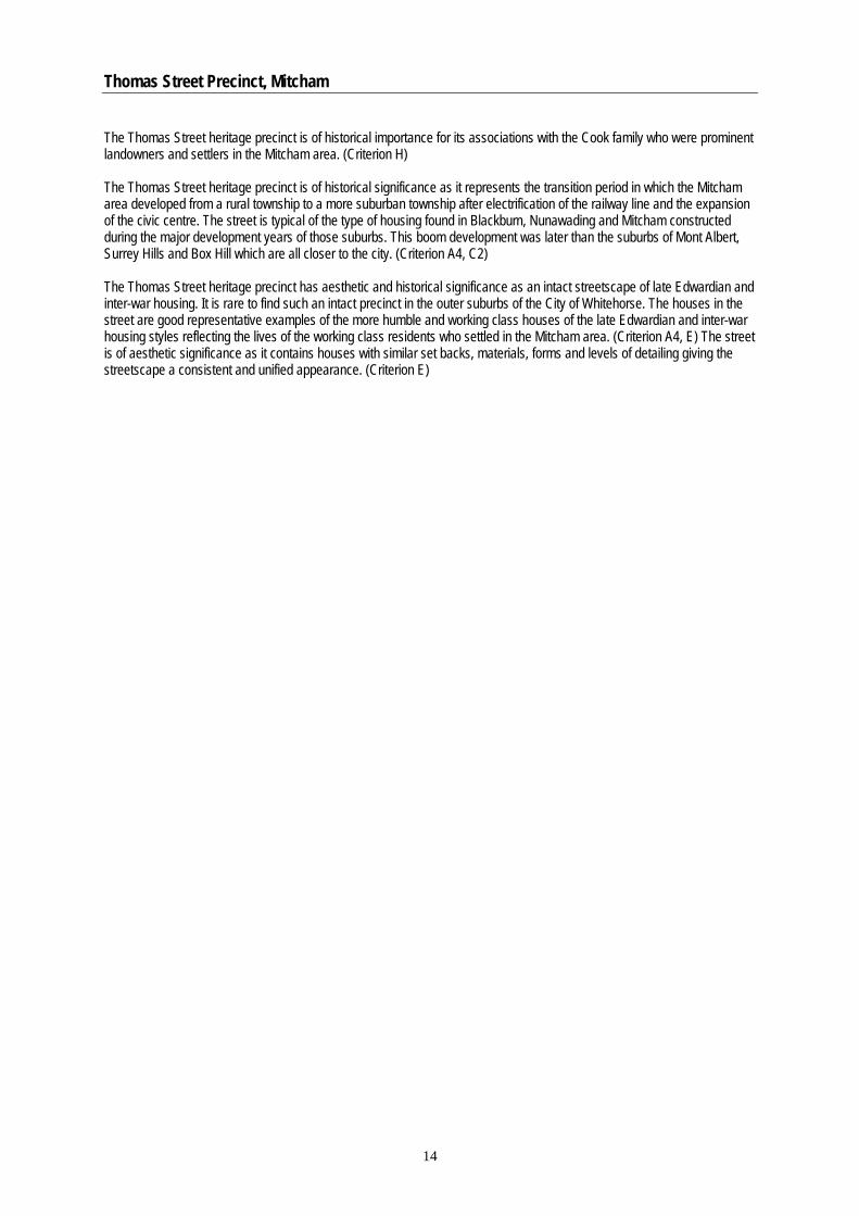
Windsor Park Estate Precinct, Surrey Hills
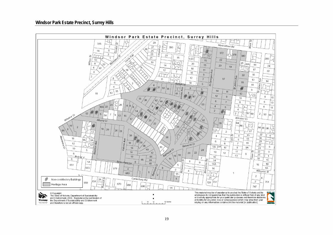
Location Canterbury Road (part), Beatrice Avenue (part), Albany Crescent, Balmoral Crescent, Albert Crescent, Windsor Crescent (part), St Georges Avenue, Louise Avenue (part), Lorne Parade (part), Leopold Crescent (part), St Johns Avenue (part). Review Andrew Ward’s Whitehorse Heritage Review 2001 identified Windsor Park Estate as a potential Heritage Overlay Precinct. Graeme Butler’s City of Whitehorse Heritage Review: Heritage Overlay Precincts 2002 confirmed the precincts worthiness for inclusion in the Heritage Overlay. History The Lilydale Railway opened in 1882 and with it the Surrey Hills railway station, gaining full service by 1883. Another platform at Surrey Hills station and the opening of nearby Mont Albert station occurred in 1890, providing the basis for suburban life and the Land Boom. Electrification of the line in 1922 meant another boost to development potential. Meanwhile tramways came from Camberwell to Warrigal Road by 1916 and on to Elgar Road by 1925. The Surrey Hills No. 1 Reservoir was completed in 1891 to the north of Canterbury Road allowing the Yan Yean MMBW water supply to be reticulated from there to surrounding homes, providing a further boost to development.40
The land to the north of Canterbury Road forms part of the Freehold Investment and Banking Co. Ltd’s Windsor Park Estate of 1883. Formed in 1882 by Sir Matthew Davies, a politician and land developer, the company undertook this subdivision as its largest venture prior to failure in the 1890s depression.41 Windsor Park was not just to be a sale of building blocks; it was to be a development. The promoters had to provide a reason for potential buyers to purchase a block in an almost uninhabited area, and consequently they presented the idea of what Surrey Hills could be; they gave it a character, and passed it off as the idyllic suburb of the future. Trees, which might one day grow into leafy avenues, were planted everywhere, and half a dozen houses were built to give the place an air of going ahead. Three were cottages; the other three were spacious villas of six or seven rooms. Surrey Hills was being designed to appeal to the prosperous citizen. In the advertising brochure it was claimed that the land had been subdivided with the utmost attention in regard to appearance and drainage and commanded the most magnificent views within 8 miles of Melbourne.42
When the first stage of Windsor Park was released on 1st December, 1883, all lots were sold. Inducements to buy included discounts to those building within twelve months, railway passes, and the reality of scenic views with avenues planted with English Oaks and elms.43
40 Butler, Graeme & Associates, Whitehorse Heritage Review 2001, Part 2, Assessment of Precincts, 2002, p. 156 41 Andrew C Ward & Associates, Heritage and Conservation Study, Volume 1, City of Box Hill, 1990, p. 100 42 Surrey Hills Walkabouts 43 Andrew C Ward & Associates, Op. Cit. 1990, p. 100
16
Windsor Park Estate Precinct, Surrey Hills
About 1500 people were reported to have attended the sale. Bidding was brisk yielding a total of £4754.13.10d for the 61 lots an average of £78 per lot.44
The Windsor Park area came from an 1883 subdivision of Elgar's Special Survey, Boroondara Parish (LP 532). This part of the estate was bound by Windsor on the west, Albany on the north, Canterbury Rd on the south and Valonia Ave on the east: it contained 61 lots typically 70'x 165'. Street name changes included Victoria Ave to Valonia c1931 and Alexandra Ave to Alexandra Crescent c1895. The survey drawing showed trees dotted along each street at about 110' centres. In 1884 the distinctive succession of crescents was created, including Albany, Windsor and Balmoral. The plan was declared by Thomas Bingham Muntz, surveyor (LP570-1).45 An earlier 1883 segment of this plan included Alexandra Crescent and Valonia Avenue, with sites in Windsor Crescent (LP570-2). Another part of the estate was between Leopold and Windsor Crescents, Mont Albert Rd and St Georges Avenue (LP661). Thomas Bingham Muntz, surveyor, also declared this in 1884. The 49-acre section east of Balmoral Crescent and St Georges Avenue extended to View and Tower Streets on the east. This was in 1885 (LP831).46 By the 1890s 46 timber and 17 brick houses occupied the Windsor Park Estate. The Railway Station at Surrey Hills had been opened in August, 1883, and the school had followed in 1890.47
A view of Windsor Crescent in c1907-11 shows advanced street trees along one side of the road and newly planted trees in picket guards on the other. Villas are apparent among the vacant lots. Bluestone pitchers take the storm water across the end of the road and along one of its sides while the road itself is gravelled. Picket and paling boundary fences extend as far as the eye can see.48
By 1927 (MMBW litho no. 73) over half the available blocks had been built on and development was to continue until the present time although houses erected during the post war years have replaced earlier timber houses.49
Earlier in the 1900s the senior schoolboys used this corner paddock of Valonia Avenue as a hockey field. At the eastern end of Windsor Crescent were early houses built principally for workers at the Box Hill Quarry and brickworks. The area was known as Irish Town. Lorne Parade Park was a swing park early in the 1900s. This land was bought from J. A. Dyer in the 1880s as a possible site for the State School but objections were received because of the proximity to the Railway line, which caused the Education Department to abandon the plan. Description The Windsor Park Estate heritage precinct consists largely of inter-war detached single storey houses, built around and in between a core of some large Edwardian and Victorian-era villas. Wall finishes are generally weatherboard but also include a number of stucco, face brick and combinations. Terracotta Marseilles pattern tiles are used for roofs, with some slate and corrugated iron. The mature street trees and the curvilinear street pattern distinguish the area from any others in the locality. There is significant bluestone kerb and channel (mainly 3 pitcher channel) throughout most of the precinct including: Windsor Crescent; Beatrice Avenue; Albany Crescent; Balmoral Crescent; Albert Crescent; St Georges Avenue; Louise Avenue; and St Johns Avenue. Below is a list of the common characteristics of houses in the precinct:
• Victorian, Edwardian and inter-war style buildings • Single storey detached housing
44 Surrey Hills Walkabouts 45 Butler, Graeme & Associates, Op. Cit. 2002, p. 156 46 Ibid 47 Andrew C Ward & Associates, Op. Cit. 1990, p. 100 48 Ibid 49 Ibid
17

Windsor Park Estate Precinct, Surrey Hills
• Wall finishes mainly weatherboard with a few exceptions of stucco, face red brick and combinations. • Terracotta Marseilles pattern tiles and corrugated iron are used for the hipped and gabled roof forms • Timber framed windows • Either a front verandah or porch entry • Generally timber picket fences
Statement of Significance What is significant? The Windsor Park Estate heritage precinct, comprising the properties with a frontage to Canterbury Road (part), Beatrice Avenue (part), Albany Crescent, Balmoral Crescent, Albert Crescent, Windsor Crescent (part), St Georges Avenue, Louise Avenue (part), Lorne Parade (part), Leopold Crescent (part), St Johns Avenue (part) and including the curvilinear road layout, mature street trees, bluestone kerb and channeling and houses, other buildings, elements, fences and fabric remaining from the Victorian, Edwardian and inter-war periods. How is it significant? The Windsor Park Estate heritage precinct is of local historic and aesthetic significance to the City of Whitehorse. Why is it significant? The Windsor Park Estate heritage precinct is of historical significance for its associations with and representation of the land development activities of Sir Matthew Davies, which contributed to the land boom associated with the image of Marvellous Melbourne. (Criterion A4 & H) The Windsor Park Estate heritage precinct is of historical and aesthetic significance for the distinctive curvilinear road pattern set out in the Victorian era by Thomas Bingham Muntz, surveyor. It is also significant for the mature street trees that enhance the expression of the Victorian era and Edwardian era development in the estate. (Criterion A4, B2) The Windsor Park Estate heritage precinct is of historical and aesthetic significance to the extent that it represents one of the municipality’s best collections of Victorian and Edwardian Houses. In particular, such a large collection of Victorian era residences, as seen in this precinct is rare within the municipality and represents the early development of the Surrey Hills area. (Criterion A4, B2 & E) The Windsor Park Estate heritage precinct is of aesthetic significance for its collection of well preserved and visually related single storey detached residences from the Victorian, Edwardian and inter-war periods. Although spanning three main style periods, the properties demonstrate similar attributes relating to form, set backs, materials, window openings and roof forms. (Criterion E)
18
Windsor Park Estate Precinct, Surrey Hills
19


