Page 1
ENVIRONMENTAL RESOURCES MANAGEMENT ABLE UK
18-1
18 HISTORIC ENVIRONMENT
18.1 INTRODUCTION
18.1.1 This chapter provides a summary of information relating to the historic
environment of that part of the Humber Estuary and its hinterland that
will be affected by the development of the Marine Energy Park. The
term “historic environment” has been defined in Planning Policy
Statement 5 as
‘All aspects of the environment resulting from the interaction between
people and places through time, including all surviving physical remains of
past human activity, whether visible, buried or submerged, and landscaped
and planted or managed flora. Those elements of the historic environment
that hold significance are called heritage assets’.
18.1.2 In practice, the scope of the historic environment (heritage assets)
includes archaeological sites, wrecks, buildings, battlefields, parks and
gardens, hedgerows and palaeo-environmental deposits. Many of these
sites (or groups of them) that are recognised as being of national (or
international) importance are “designated”; such as World Heritage
Sites, protected wrecks, military remains, scheduled monuments, listed
buildings, conservation areas, registered parks and gardens and
registered battlefields. Other heritage assets may have significance at a
national level, but are not designated. Important hedgerows, as defined
under the Hedgerow Regulations, are not considered to be designated
heritage assets.
18.1.3 Designated assets, and other assets of high significance, are generally
protected from development that would materially affect their physical
survival or setting. Where there are overriding reasons why
development may remove or affect heritage assets of significance then
appropriate means of mitigating the adverse effects are required.
18.1.4 This chapter addresses the issue of terrestrial and marine archaeology
and details the approach to assessing the impacts of the proposed
development on terrestrial and marine archaeological resources.
18.2 LEGISLATION, POLICY AND GUIDANCE
18.2.1 National cultural heritage policies (described below as “Terrestrial
Archaeology”) apply only above Mean Low Water (MLW). Below this
it is referred to as “Marine Archaeology” and their place is taken by the
Page 2
ENVIRONMENTAL RESOURCES MANAGEMENT ABLE UK
18-2
following relevant pieces of legislation and two significant voluntary
codes of practice.
Terrestrial Archaeology
Ancient Monuments and Archaeological Areas Act 1979
18.2.2 The Ancient Monuments and Archaeological Areas Act 1979 (as
amended) requires the Secretary of state to maintain a schedule of sites
of national importance which receive statutory protection. Where
scheduled sites are affected by development proposals there is a
presumption in favour of their physical preservation. There is also a
presumption against developments which have a significant impact on
the integrity of the setting of scheduled monuments. Any works, other
than activities receiving class consent under The Ancient Monuments
(Class Consents) Order 1981 (as amended) which would have the effect
of demolishing, destroying, damaging, removing, repairing, altering,
adding to, flooding or covering up a Scheduled Ancient Monument
require consent from English Heritage, on behalf of the Secretary of
State, Department for Culture, Media and Sport.
Planning (Listed Buildings and Conservation Areas 1990
18.2.3 Planning (Listed buildings and Conservation Areas) Act 1990 protects
buildings of national, regional, or local historical and architectural
importance. Buildings designated as “Listed” are afforded protection
from physical alteration or effects on their historical setting.
The Hedgerow Regulations 1997
18.2.4 The Hedgerow Regulations 1997 affords protection to hedgerows of
historic importance. The scheme came into effect on 1 June 1997 and
any hedgerow, which is defined, at that date, as being of historical or
ecological importance may require consent from the local planning
authority prior to removal. Although afforded protection by statute,
historically important hedgerows are not considered to be “designated”
assets within the definition contained in PPS5.
National Policy Statements
National Policy Statement for Ports (NPS) 2011
18.2.5 The NPS for ports (2011) requires the applicant to consult relevant
Historic Environment Record held by regulatory authorities. Where a
development site includes heritage assets with an archaeological
interest the NPS requires a desk based assessment of the assets to be
Page 3
ENVIRONMENTAL RESOURCES MANAGEMENT ABLE UK
18-3
undertaken and, potentially, field based surveys. The decision maker is
advised
‘not (to) accept applications for consent where the extent of the impact of the
proposed development on the significance of any heritage assets affected
cannot be understood from the application and supporting documents’.
Planning Policy Guidance/Statements
Planning Policy Statement (PPS) 5: Planning for The Historic Environment
2010
18.2.6 PPS5 is the replacement for Planning Policy Guidance (PPG) Notes 15
(Planning and the Historic Environment, 1994) and 16 (Archaeology
and Planning, 1990). A separate Guidance Note has also been
published.
18.2.7 The principal objectives of the PPS5 are:
• to deliver sustainable development in the historic environment by
recognising that heritage assets are a non-renewable resource.
• to conserve assets in a manner appropriate to their significance by
ensuring that decisions are based on that significance as investigated
to a proportionate degree.
• to put the assets, where possible, to an appropriate and viable use
consistent with their conservation.
• to recognise the assets contribution to local character and sense of
place and integrate the historic environment into planning policies.
• to contribute to an understanding of the past by ensuring that
evidence is captured and made publicly available.
Local Plan Policies
North Lincolnshire Council Local Plan 2003
18.2.8 Local Plan Policy HE8 refers to Ancient Monuments, some of which are
located within the village of East Halton. The policy states that,
‘development proposals which would result in an adverse effect on
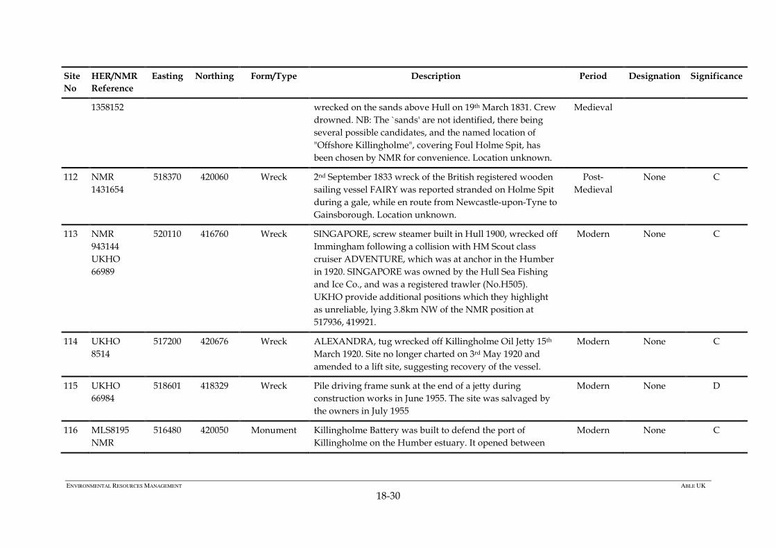
Scheduled Ancient Monuments and other nationally important
monuments, or their settings, will not be permitted’.
Page 4
ENVIRONMENTAL RESOURCES MANAGEMENT ABLE UK
18-4
18.2.9 Local Plan Policy HE9 refers to archaeological evaluation. The policy
states that,
‘sites of known archaeological importance will be protected. When
development affecting such sites is acceptable in principle, mitigation of
damage must be ensured and the preservation of the remains in situ is a
preferred solution. When in situ preservation is not justified, the developer
will be required to make adequate provision for excavation and recording
before and during development.’
North Lincolnshire Core Strategy 2011
18.2.10 Policy CS6 HISTORIC ENVIRONMENT states that, the council will
promote the effective management of North Lincolnshire’s historic
assets through:
• Safeguarding the nationally significant medieval landscapes of the
Isle of Axholme (notably the open strip fields and turbaries) and
supporting initiatives which seek to realise the potential of these
areas as a tourist, educational and environmental resource.
• Preserving and enhancing the rich archaeological heritage of North
Lincolnshire.
• Ensuring that development within Epworth (including schemes
needed to exploit the economic potential of the Wesleys or manage
visitors) safeguards and, where possible, improves the setting of
buildings associated with its Methodist heritage.
• Ensuring that development within North Lincolnshire’s Market
Towns safeguards their distinctive character and landscape setting,
especially Barton upon Humber, Crowle and Epworth.
• The council will seek to protect, conserve and enhance North
Lincolnshire’s historic environment, as well as the character and
setting of areas of acknowledged importance including historic
buildings, conservation areas, listed buildings (both statutory and
locally listed), registered parks and gardens, scheduled ancient
monuments and archaeological remains.
• All new development must respect and enhance the local character
and distinctiveness of the area in which it would be situated,
particularly in areas with high heritage value.
• Development proposals should provide archaeological assessments
where appropriate.
Page 5
ENVIRONMENTAL RESOURCES MANAGEMENT ABLE UK
18-5
Marine Archaeology
The Protection of Wrecks Act 1973
18.2.11 The Protection of Wrecks Act, 1973, enables the Secretary of State to
make orders to protect certain wreck sites in United Kingdom waters
from unauthorised interference on account of either their historic,
archaeological or artistic importance or their potentially dangerous
condition.
The Protection of Military Remains Act 1986
18.2.12 This Act makes it an offence to interfere with the wreckage of any
crashed, sunken or stranded military aircraft or designated vessel
without a licence. All crashed military aircraft receive automatic
protection, but the Ministry of Defence (MOD) must individually
designate vessels.
The Merchant Shipping Act 1995
18.2.13 This Act states that any material brought to the surface must be
declared to the Receiver of the Wreck. The Receiver aims to place all
‘historical’ finds (those over 100 years old) in museums or similar
institutions.
UK High Level Marine Objectives (DEFRA 2009)
18.2.14 The UK government high level marine objectives (Our Seas – A Shared
Resource) outline the government wide objectives to achieve sustainable
development in the marine environment. The objectives state that the
marine historic environment includes ‘Individual sites and assets of
historic, archaeological, architectural or artistic interest, whether or not they
are afforded statutory protection by heritage protection legislation’. The
objectives also promote the use of spatial planning which ‘recognises the
protection and management needs of marine cultural heritage according to its
significance.’
Marine and Coastal Access Act 2009
18.2.15 This Act introduced a new system of marine planning across the UK,
supported by a Marine Policy Statement adopted in March 2011 and
Marine Plans, which are currently in development. The new system for
marine planning dovetails with terrestrial Planning Policy Statements.
The Marine Policy Statement requires the consideration of seascapes
and the historic environment based on the following principles:
Page 6
ENVIRONMENTAL RESOURCES MANAGEMENT ABLE UK
18-6
• The historic environment should be conserved in a manner
appropriate and proportionate to its significance.
• Opportunities should be taken to contribute to our knowledge and
understanding of our past from the historic environment and making
this publicly available, particularly if a heritage asset is to be lost.
• The absence of designation for heritage assets does not necessarily
indicate lower significance and non-designated assets should be
considered subject to the same policy principles as designated
heritage assets.
• Developments proposals should avoid or minimise conflict with the
conservation of an asset’s significance.
• Developments should adopt a general presumption in favour of the
conservation of designated heritage assets within an appropriate
setting proportionate to its significance.
• Substantial loss or harm to designated assets should be exceptional.
• Where the loss of the whole or a material part of a heritage asset’s
significance is justified, suitable mitigating actions should be
required to record and advance understanding of the significance of
the heritage asset before it is lost.
Other Guidance
18.2.16 In addition to the policy framework set out above, the preparation of
the assessment also considers guidance set out in the following;
• (English Heritage 2006) Ports: the impact of development on the
maritime historic environment. London.
• (English Heritage 2007) Wind Energy and the Historic Environment
– Guidance for developers of wind energy projects. London.
• (English Heritage 2008) Conservation Principles, Policies and
Guidance for the sustainable management of the historic
environment. London.
• (English Heritage 2010) Planning Policy Statement (PPS) 5: Historic
Environment Planning Practice Guide.
Page 7
ENVIRONMENTAL RESOURCES MANAGEMENT ABLE UK
18-7
• (English Heritage 2011a) Seeing the History in the View: A method
for assessing heritage significance within views.
• (English Heritage 2011b) The Setting of Heritage Assets: English
Heritage Guidance.
• (BMAPA (British Marine Aggregates Producers Association) /
English Heritage 2005) Protocol for Reporting Finds of
Archaeological Interest.
http://www.wessexarch.co.uk/files/projects/BMAPA-
Protocol/protocol_text.pdf.
• (COWRIE (Collaborative Offshore Wind Research into the
Environment) 2007) Historic Environment Guidance for the Offshore
Renewable Energy
Sector.;http://www.offshorewind.co.uk/Assets/archaeo_guidance.
pdf.
• (COWRIE 2011) Offshore Geotechnical Investigations and Historic
Environment Analysis: Guidance for the Renewable Energy Sector.
http://www.offshorewind.co.uk/Assets/final%20GEORARCH-
09%20Offshore%20Geotech%20Guidance%20web.pdf.
• (The Crown Estate 2010) Model Clauses for Archaeological Written
Schemes of Investigation.
http://www.thecrownestate.co.uk/wsi_renewables.pdf.;
• (The Crown Estate 2010) Protocol for Archaeological Discoveries:
Offshore Renewables Projects.
http://www.thecrownestate.co.uk/pad_offshore_renewables.pdf ;
18.3 ASSESSMENT METHODOLOGY AND CRITERIA
Overview
Marine Historic Environment
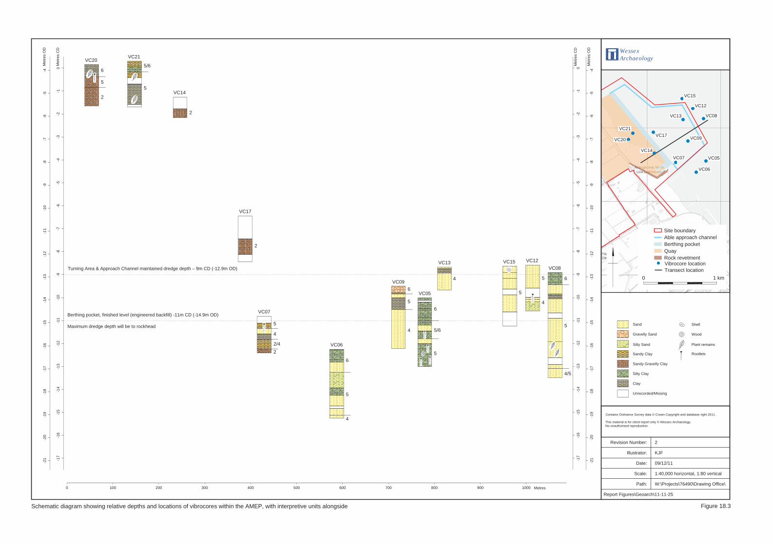
18.3.1 The current data acquired for the assessment of marine heritage assets
has comprised a desk-based assessment and is set out in the desk study
undertaken by Humber Field Archaeology in 2010. This report is
included as Annex 18.1. The study incorporates an assessment of
existing literature and databases searches; results from a geophysical
survey (Ferris 2010) undertaken in June 2010, which incorporated
boomer survey, bathymetry and magnetometer survey; and results of a
Page 8
ENVIRONMENTAL RESOURCES MANAGEMENT ABLE UK
18-8
vibrocore survey undertaken in July 2010. Further work incorporated
into this chapter has included a re-assessment of existing literature and
database searches, an assessment of historic charts held by the UKHO
and the results of a walkover survey of the foreshore. It is anticipated
that further work will be carried out to refine the details of mitigation
following consent.
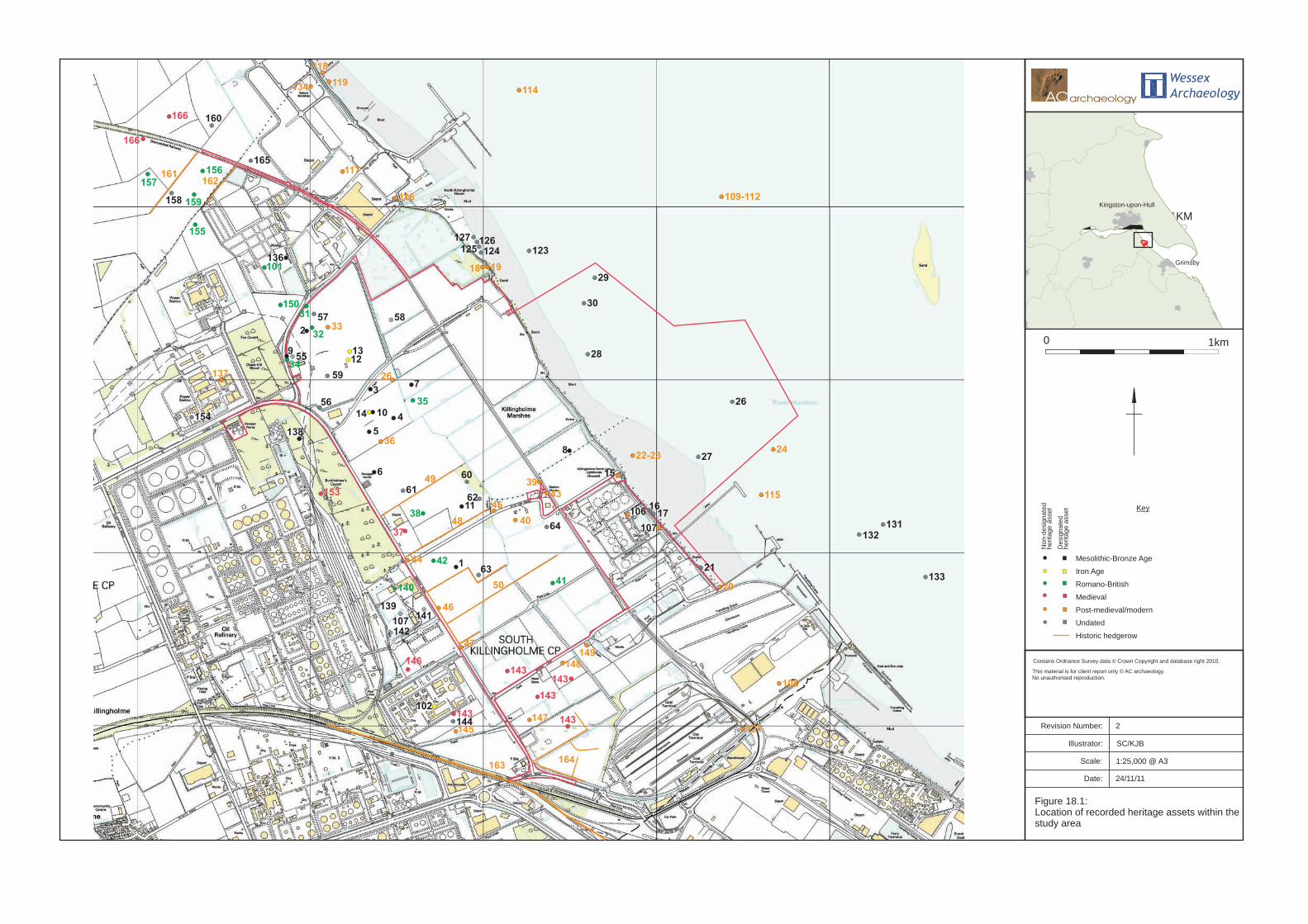
18.3.2 The extent of data searches undertaken for the marine historic
environment has included all assets within the AMEP plus the closest
relevant assets, up to 5km from the AMEP (Figure 18.1).
Terrestrial Historic Environment
18.3.3 The current data acquired for the assessment of terrestrial heritage
assets has comprised a desk-based assessment of the proposed
development on the south shore of the Humber Estuary (Cottam & Cox
2011a), followed by extensive geophysical survey of sample transects
across 100 hectares of the AMEP site (GSB Prospection 2011), and an
assessment of the setting, using public access, of designated assets
within the broad study area (Cottam & Cox 2011b).
18.3.4 The desk study incorporates an assessment of existing literature and
database searches and is included here as Annex 18.2. It includes a
significant amount of information acquired from geophysical surveys,
fieldwalking, trial trenching and archaeological excavation undertaken
in previously–developed land in the north sector of the application
area. The extent of the data searches undertaken for the terrestrial
historic environment has generally included all assets within the
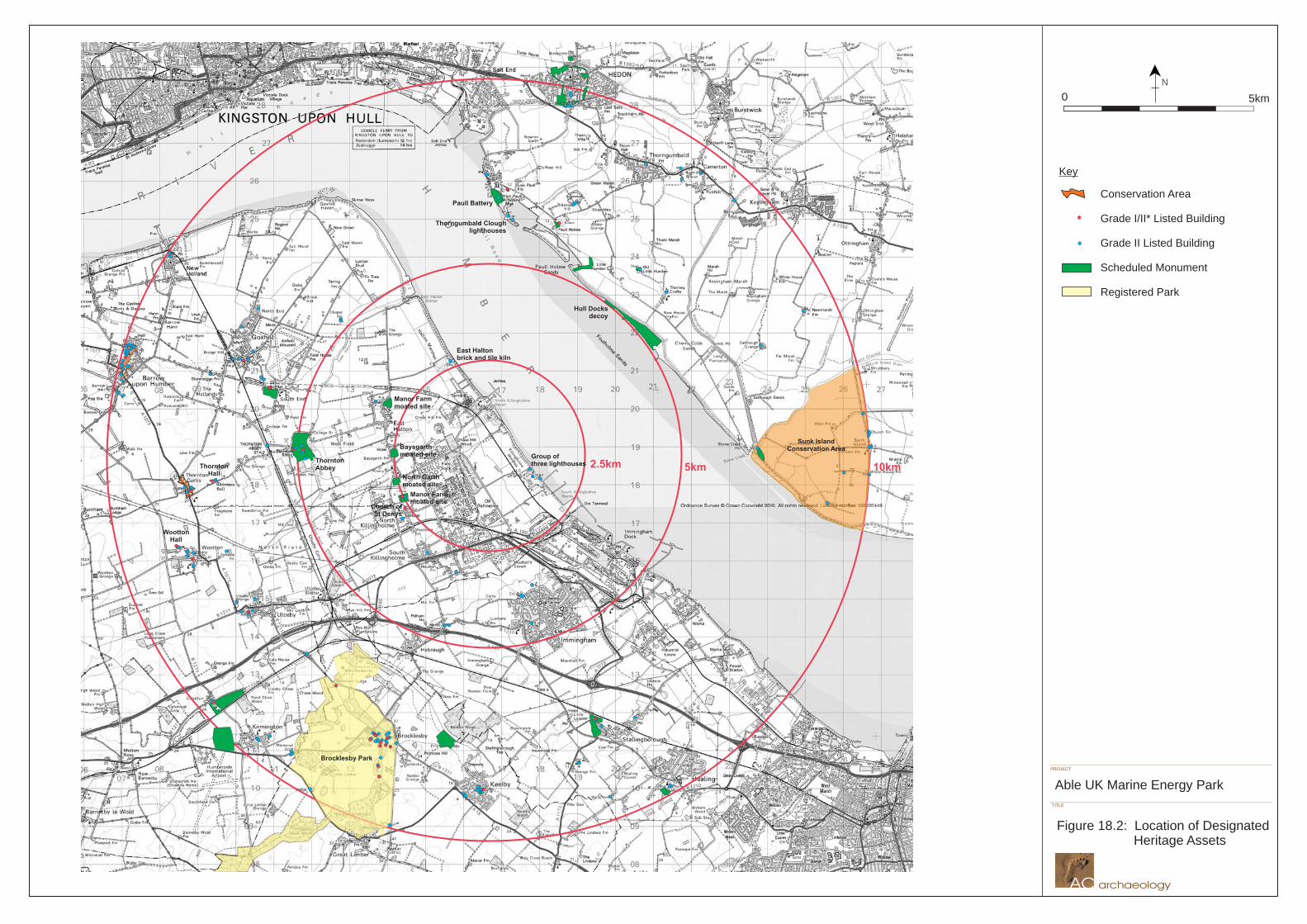
application area plus up to 500 m around the site (Figure 18.2).
18.3.5 The more recent geophysical survey, by gradiometer, included
approximately 100 hectares of previously undeveloped land, in the
central and southern zones of the AMEP site, using an alternate, 10m-
wide strip, recording approach. The report is included here as Annex
18.3.
18.3.6 To assess the setting of heritage assets, potentially sensitive receptors
have been identified from an area up to 10 km from the AMEP site (the
broad study area) as shown on Figure. 18.2. Those assets considered to
lie within the Zone of Theoretical Visibility (ZTV) of the turbines,
defined in Chapter 20 of this Environment Statement (Figure 20.3a), have
been visited, where access has allowed, and the contribution of the
setting to the significance of the asset considered. The results of this
assessment are set out in Annex 18.4. Marine assets below low water
are not considered to have a setting for the purpose of this assessment.
Page 9
ENVIRONMENTAL RESOURCES MANAGEMENT ABLE UK
18-9
Significance Criteria
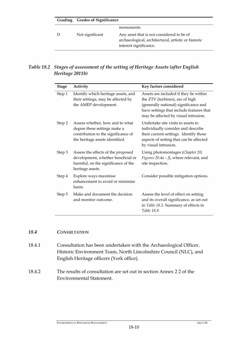
18.3.7 PPS5 provides no terminology for ranking the relative significance of
non-designated heritage assets. It is therefore necessary to define a
method for the assessment of individual heritage features. In the
absence of a nationally accepted means of ranking the importance of
archaeological and cultural heritage assets (other than the Secretary of
State’s non-statutory criteria for the assessment of national importance
– principally condition, period, rarity, group value and survival), a set
of terms has been applied in order to provide a comparison of the
relative importance of any cultural heritage features present on the site.
The gradings are set out in Table 18.1 and defined for each asset in
Annexes 18.1 – 18.3. Most non-designated archaeological assets in the
study areas are considered to be of local or county significance, based
largely on their evidential or historical value.
18.3.8 In addition, where assets have been identified that are of high
(generally national) significance then further assessment of the asset’s
setting has been undertaken using the guidance for the assessment of
the value of heritage assets set out in PPS5, along with Conservation
Principles (English Heritage, 2008) and the guidance on heritage
significance within views (English Heritage 2011a) and the setting of
heritage assets (English Heritage 2011b). The assessment concentrates
on those nationally important heritage assets where it is considered that
the visual setting contributes to the significance of the asset, and where
intrusion into those views, either into or from of the asset, may have an
effect on that aspect of the setting. The stages of assessment are shown
in Table 18.2.
Table 18.1 Ranking of Significance of Heritage Assets
Grading Grades of Significance
A National significance Any designated or other asset considered to be of
national significance due to its archaeological,
architectural, artistic or historic interest. The asset
would score high using the non-statutory criteria
for assessing scheduled monuments.
B Regional/County
significance
Any asset considered to be of regional or county
significance due to its archaeological, architectural,
artistic or historic interest. The asset would score
moderate using the non-statutory criteria for
assessing scheduled monuments.
C Local significance Any asset considered to be of local significance due
to its archaeological, architectural, artistic or
historic interest. The asset would score low using
the non-statutory criteria for assessing scheduled
Page 10
ENVIRONMENTAL RESOURCES MANAGEMENT ABLE UK
18-10
Grading Grades of Significance
monuments.
D Not significant Any asset that is not considered to be of
archaeological, architectural, artistic or historic
interest significance.
Table 18.2 Stages of assessment of the setting of Heritage Assets (after English
Heritage 2011b)
Stage Activity Key factors considered
Step 1 Identify which heritage assets, and
their settings, may be affected by
the AMEP development.
Assets are included if they lie within
the ZTV (turbines), are of high
(generally national) significance and
have settings that include features that
may be affected by visual intrusion.
Step 2 Assess whether, how and to what
degree these settings make a
contribution to the significance of
the heritage assets identified.
Undertake site visits to assets to
individually consider and describe
their current settings. Identify those
aspects of setting that can be affected
by visual intrusion.
Step 3 Assess the effects of the proposed
development, whether beneficial or
harmful, on the significance of the
heritage assets.
Using photomontages (Chapter 20;
Figures 20.4a – f), where relevant, and
site inspection.
Step 4 Explore ways maximise
enhancement to avoid or minimise
harm.
Consider possible mitigation options.
Step 5 Make and document the decision
and monitor outcome.
Assess the level of effect on setting
and its overall significance, as set out
in Table 18.5. Summary of effects in
Table 18.9.
18.4 CONSULTATION
18.4.1 Consultation has been undertaken with the Archaeological Officer,
Historic Environment Team, North Lincolnshire Council (NLC), and
English Heritage officers (York office).
18.4.2 The results of consultation are set out in section Annex 2 2 of the
Environmental Statement.
Page 11
ENVIRONMENTAL RESOURCES MANAGEMENT ABLE UK
18-11
18.5 BASELINE ENVIRONMENT
Designated Heritage Assets within Broad Study Area
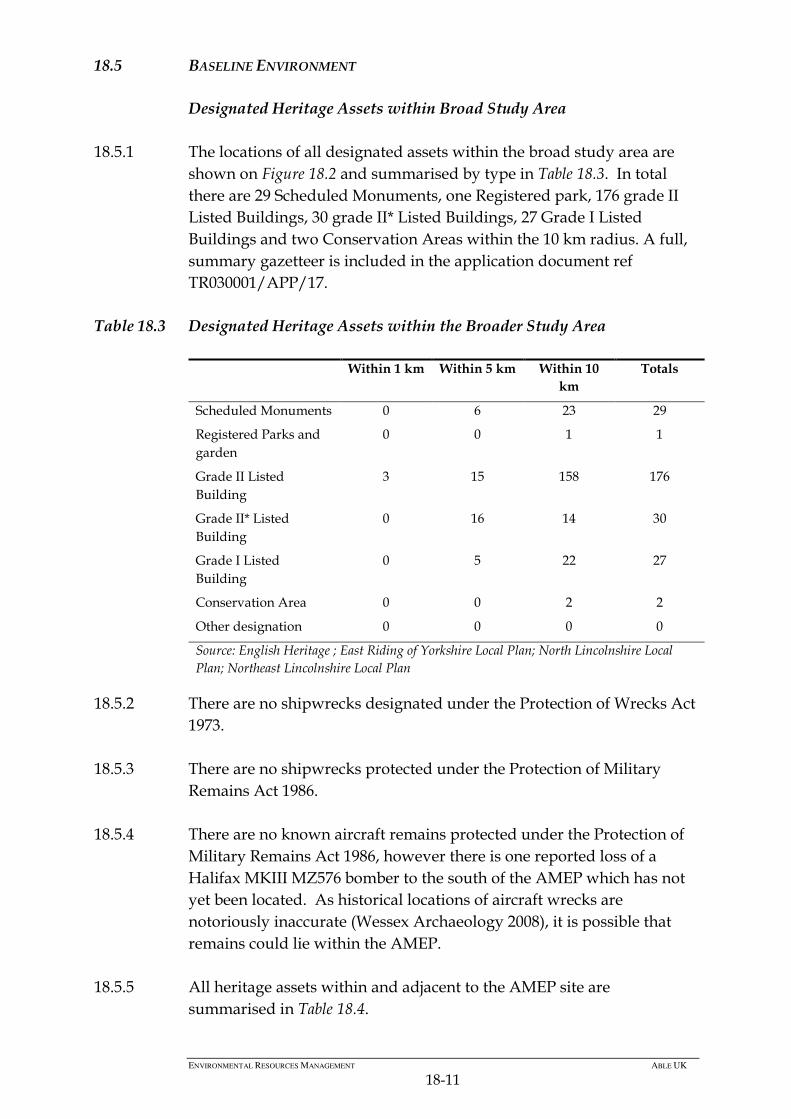
18.5.1 The locations of all designated assets within the broad study area are
shown on Figure 18.2 and summarised by type in Table 18.3. In total
there are 29 Scheduled Monuments, one Registered park, 176 grade II
Listed Buildings, 30 grade II* Listed Buildings, 27 Grade I Listed
Buildings and two Conservation Areas within the 10 km radius. A full,
summary gazetteer is included in the application document ref
TR030001/APP/17.
Table 18.3 Designated Heritage Assets within the Broader Study Area
Within 1 km Within 5 km Within 10
km
Totals
Scheduled Monuments 0 6 23 29
Registered Parks and
garden
0 0 1 1
Grade II Listed
Building
3 15 158 176
Grade II* Listed
Building
0 16 14 30
Grade I Listed
Building
0 5 22 27
Conservation Area 0 0 2 2
Other designation 0 0 0 0
Source: English Heritage ; East Riding of Yorkshire Local Plan; North Lincolnshire Local
Plan; Northeast Lincolnshire Local Plan
18.5.2 There are no shipwrecks designated under the Protection of Wrecks Act
1973.
18.5.3 There are no shipwrecks protected under the Protection of Military
Remains Act 1986.
18.5.4 There are no known aircraft remains protected under the Protection of
Military Remains Act 1986, however there is one reported loss of a
Halifax MKIII MZ576 bomber to the south of the AMEP which has not
yet been located. As historical locations of aircraft wrecks are
notoriously inaccurate (Wessex Archaeology 2008), it is possible that
remains could lie within the AMEP.
18.5.5 All heritage assets within and adjacent to the AMEP site are
summarised in Table 18.4.
Page 12
ENVIRONMENTAL RESOURCES MANAGEMENT ABLE UK
18-12
Table 18.4 Heritage Assets within the Study Area
Site
No
HER/NMR
Reference
Easting Northing Form/Type Description Period Designation Significance
1 MLS19726 516840 417910 Findspot A core and three flakes found near Killingholme Marshes
during HWP fieldwalking. Two pieces are of till A flint and
two of till B flint. The core is a late Mesolithic blade core
with two plain striking platforms; one large platform has at
least 18 blade-like removals and the second has at least
seven flakes removed. The core retains a small patch of
cortex at the distal end. One flake is blade-like and may be
of a similar date to the core. One flake has a plain striking
platform and one has a shattered platform. One has a
pronounced bulb of percussion and one has a flat bulb. One
flake is utilised. All three are secondary flakes. Two of the
flakes are likely to be of a later date than the core and the
blade-like flake, possibly dating to the Bronze Age.
Late
Mesolithic –
Bronze Age
None C
2 MLS19797 515990 419280 Findspot Part of a core of till A flint with at least eight blade-like
flakes removed from a single plain striking platform. The
worked edge also appears to have been used as a scraper.
Late
Mesolithic
to Late
Neolithic
None C
3 MLS19800 516360 418950 Findspot Four flakes and a chunk of till A flint. Two are recorticated
and patinated, one is complete and two have some post-
depositional damage. One flake has a plain striking
platform and a diffuse bulb of percussion. Three are
secondary flakes and one is a tertiary removal.
Late
Mesolithic
to Late
Neolithic
None C
4 MLS19801 516490 418780 Findspot Three secondary flakes of till A flint, two having some post-
depositional damage.
Late
Mesolithic
None C
Page 13
ENVIRONMENTAL RESOURCES MANAGEMENT ABLE UK
18-13
Site
No
HER/NMR
Reference
Easting Northing Form/Type Description Period Designation Significance
to Late
Neolithic
5 MLS19802 516350 418700 Findspot Five secondary flakes of recorticated till A flint. Three are
patinated and three have some post-depositional damage.
Most have been utilised and are worn along the edges.
Late
Mesolithic
to Late
Neolithic
None C
6 MLS19803 516380 418470 Findspot A complete secondary flake of till B flint, with a plain
striking platform, a pronounced bulb of percussion and
some post-depositional damage. This site was listed in a
desk-based assessment produced by AC Archaeology in
2006. No additional information.
Late
Mesolithic
to Late
Neolithic
None C
7 MLS 19805 516590 418970 Findspot A tertiary flake of till A flint with a hinge termination. Late
Mesolithic
to Late
Neolithic
None C
8 MLS 19808 517500 418590 Findspot A tertiary flake of recorticated till A flint, with a large fault
within the centre of the flint. It has been utilised along one
edge.
Late
Mesolithic
to Late
Neolithic
None C
9 MLS 20198 515870 419130 Findspot A rod microlith was found in Trench 6 context 106 (the fill
of a Roman ditch) during an evaluation in advance of the
Clough Road Realignment, 2004. Measuring 27.2 x 7 x
1.8mm, it is blunted down the left margin with fine sub-
parallel retouch. Made on a blade blank, the base is hollow
and the distal end forms a crescent. Residual chalk cortex
Late
Mesolithic
None C
Page 14
ENVIRONMENTAL RESOURCES MANAGEMENT ABLE UK
18-14
Site
No
HER/NMR
Reference
Easting Northing Form/Type Description Period Designation Significance
suggests an east coast origin for the flint.
Two other undiagnostic pieces of worked flint were found
in the same context. One is a proximal primary flake made
on speckled grey flint and is partially patinated. The other
is also a proximal primary flake, made on olive grey flint,
the distal end has evidence of platform preparation from an
earlier removal. This site was listed in a desk-based
assessment produced by AC Archaeology in 2006. No
additional information.
10 MLS 20440 516370 418810 Findspot A small assemblage of 27 pieces of worked flint, found in 8
trial trenches during an evaluation carried out by Lindsey
Archaeological Services for Able UK. The majority of the
flint was found in Trenches 3 and 7, located on the slightly
higher ground in the north-western corner of the
application area.
The assemblage comprised 2 scrapers, 1 scraper/knife, 11
flakes, 1 notched piece, 1 retouched piece, 2 retouched
flakes, 1 blade, 2 blade-like flakes, 1 core and 5 pieces of
debitage.
The limited quantity of artefacts, and the absence of burnt
flint, suggests that there was no sustained occupation in
this area prior to the Iron Age, rather a series of transient
visits for specific activities. It is possible that the gathering
of flint from the boulder clay was one of these activities, as
there are several reworked natural flakes from that source
within this assemblage. The higher densities of lithic
artefacts in the trenches on the higher ground imply that
this was a favoured location, overlooking the landscape to
Early
Mesolithic
to Early
Bronze Age
None C
Page 15
ENVIRONMENTAL RESOURCES MANAGEMENT ABLE UK
18-15
Site
No
HER/NMR
Reference
Easting Northing Form/Type Description Period Designation Significance
the north, east and south-east.
11 MLS19727 516900 418200 Artefact
Scatter
A scraper, two cores, nine flakes and a chunk were found to
the west of Killingholme Marshes. Eight pieces are of till A
flint and five of till B flint. Two are recorticated. Three
pieces are complete and two have some post-depositional
damage. The scraper is on an incomplete secondary flake
that retains about 30% cortex. It has abrupt retouch along
the distal section of the left edge. Both cores are incomplete,
but still show evidence for rejuvenation. They both have
one striking platform from which flakes have been
removed. One has at least 13 flakes removed and the other
at least 16. One of the flakes is a core rejuvenation piece,
which has removed a large plain striking platform from a
core. It has a cortical striking platform and a pronounced
bulb of percussion. Two flakes have plain striking
platforms and diffuse bulbs of percussion, and two have
hinge terminations. Seven flakes are secondary removals
and one is a tertiary flake. The only piece within this
assemblage that is likely to be datable is a blade-like flake
that could date from the Neolithic period. However, this
piece is out of character amongst the rest of the assemblage,
which is more likely to be of a later date.
Neolithic/
Bronze Age
None C
12 - 517571 419443 Magnetometer
anomaly
Apparently multiple objects, relative target size 11.41. Unknown None C
13 MLS20140 516240 419160 Monument A geophysical survey carried out in 2003 identified a
cluster of ditch type anomalies, revealed one side of a
rectangular enclosure, with a width of 27 metres.
Iron Age None B
Page 16
ENVIRONMENTAL RESOURCES MANAGEMENT ABLE UK
18-16
Site
No
HER/NMR
Reference
Easting Northing Form/Type Description Period Designation Significance
Fragmentary anomalies were also detected inside the
enclosure, which may have been sited on a low rise above
wetter ground. An archaeological evaluation was carried in
June 2004. Trenches targeted the enclosure and revealed
archaeological deposits sealed beneath a thick layer of
estuarine alluvium.
The northern enclosure ditch was 2.42m wide, aligned east-
west. 10.2 metres to the south was a larger, parallel ditch,
measuring 3.55m wide. Six fill deposits were identified; the
secondary fill contained frequent animal bone with
occasional pottery and stone fragments. The upper fill
contained heat affected stones, animal bone and frequent
pottery, evidence for nearby domestic activity. A further
parallel ditch was observed 26.5m to the south of the
second, and was about the same width (4m). It was 1m
deep. The primary fill of silty clay with stone fragments
seemed to have been tipped into the ditch from the north,
i.e. from within the enclosure. The secondary fill contained
pottery; the upper fill contained stone fragments, animal
bone and pottery.
Within the area bounded by the enclosure ditches, a
curvilinear feature was exposed which was interpreted as
the drip gully of a roundhouse. It was between 0.65m and
2.25m wide, and may have been re-cut. The fill contained
occasional bone and frequent pottery. Two post holes were
located at the east of the circumference of the gully,
suggesting an entrance. Other post or stake holes in the
vicinity appeared to define two sides of a possible porch.
Page 17
ENVIRONMENTAL RESOURCES MANAGEMENT ABLE UK
18-17
Site
No
HER/NMR
Reference
Easting Northing Form/Type Description Period Designation Significance
The eastern edge of the gully was truncated by a north-
south ditch, 1.25m wide and up to 0.75m deep. It may
represent an internal division within the enclosure, created
after the roundhouse had fallen out of use.
The western arm of the main enclosure ditch contained five
fills that contained animal bone, charcoal, fired clay and a
small pottery group. Further east inside the enclosure, were
pits and postholes. The eastern enclosure ditch had not
been detected by geophysical survey due to the thick
deposit of alluvium overlying it.
Of the 277 sherds of hand-made Iron Age pottery, the
majority were stone-tempered pottery, hard fired and
reduced, with some exterior oxidation, the dominant form
being the jar. Some examples paralleling those from Phase 2
at Weelsby Avenue, which have been dated to the Middle
Iron Age.
Bone fragments collected during the investigation included
cattle, sheep/goat and horse. Butchery marks were
recorded on only two bones, but it is thought that the
assemblage represented butchery waste and/or domestic
refuse.
Some plant seeds were identified including a large number
of cereal grains, the majority being bread/spelt wheat.
Weed seeds indicative of arable fields were within the same
samples, suggesting that the material was probably crop
processing waste.
14 MLS20441 516355 418823 Monument A geophysical survey carried out in 2005 identified a
probable Iron Age/Romano-British enclosure complex. It
Iron Age/
Romano-
None B
Page 18
ENVIRONMENTAL RESOURCES MANAGEMENT ABLE UK
18-18
Site
No
HER/NMR
Reference
Easting Northing Form/Type Description Period Designation Significance
was ovoid in shape measuring 65m by 45m with an internal
ditch dividing the enclosure into two discrete areas. Other
short linear ditches were detected both inside and outside
the enclosure, and pits and/or areas of burnt material were
also detected within the enclosure.
Subsequently 46 evaluation trenches were excavated by
LAS. In the north-western quarter of the enclosure, the
main ditch was found to be 5m wide and in excess of 1.5m
deep, having been re-cut on at least five occasions, moving
progressively west. To the east of the main ditch was a sub-
rectangular aligned ditch, cut by a wider and shallower
ditch on a different alignment. A curvilinear ditch was also
recorded, which may have been the drip gully of a circular
building (roundhouse).
The main ditch in the south-eastern part of the enclosure
had be re-cut four times. The earliest ditch cut contained
middle Iron Age pottery, while the first and third re-cuts
both contained late Iron Age and Roman pottery. The
single fill of the final re-cut contained middle Iron Age
pottery. East of the main ditch, within the enclosure, was a
length of curvilinear gully with part of a rectangular
enclosure within the main enclosure.
A trench located within the south eastern quarter of the
enclosure recorded a series of intercutting ditches, whilst
another positioned to investigate the terminal of a ditch on
the east side of the enclosure also recorded curving ditch
containing Romano-British pottery of 2nd Century AD.
Further 2nd Century AD pottery was recovered from a ditch
British
Page 19
ENVIRONMENTAL RESOURCES MANAGEMENT ABLE UK
18-19
Site
No
HER/NMR
Reference
Easting Northing Form/Type Description Period Designation Significance
lying outside the enclosure and to the east of it.
Subsequent open area excavation established that the
archaeological remains consisted of two enclosures and
three roundhouses but the full extent of the settlement was
not established within the excavation area with activity
extending both to the east and west beyond the limit of the
excavation. All activity here has been dated to sometime
within the late Iron Age (3rd to 1st century BC) representing
settlement development of unknown duration within this
period. Three sub-phases were identified of small scale
changes within an essentially static farmstead.
The Iron Age pottery ranges from the middle to late Iron
Age, with erratic-tempered ware and slag-tempered ware
the predominant types. Shell gritted wares, normally more
abundant on Lincolnshire sites, take second place, and are
mostly later in date. At least one type is known to occur in
the 1st and 2nd centuries AD. The Roman pottery included a
rusticated jar fragment of the late 1st to early/mid 2nd
century, a curved rim jar of the early-mid 2nd century and a
lid-seated jar of the same date. A single sherd of Samian
ware was found from a mid 2nd century cup. There were no
Roman sherds later than this date.
15 MLS8618 517778 418443 Extant
Structure
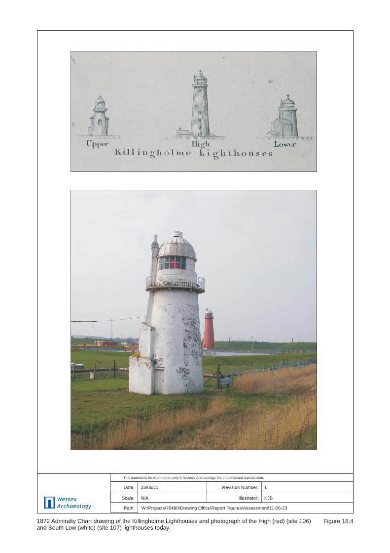
Killingholme North Low lighthouse. Lighthouse and
adjacent lighthouse keepers house, now house. Built 1851
by William Foale for Trinity House, with later alterations
and additions to rear. The lighthouse was used as a signal
station for trawlers until 1920. Grade II listed.
Post-
Medieval
Grade II
Listed
Building
A
Page 20
ENVIRONMENTAL RESOURCES MANAGEMENT ABLE UK
18-20
Site
No
HER/NMR
Reference
Easting Northing Form/Type Description Period Designation Significance
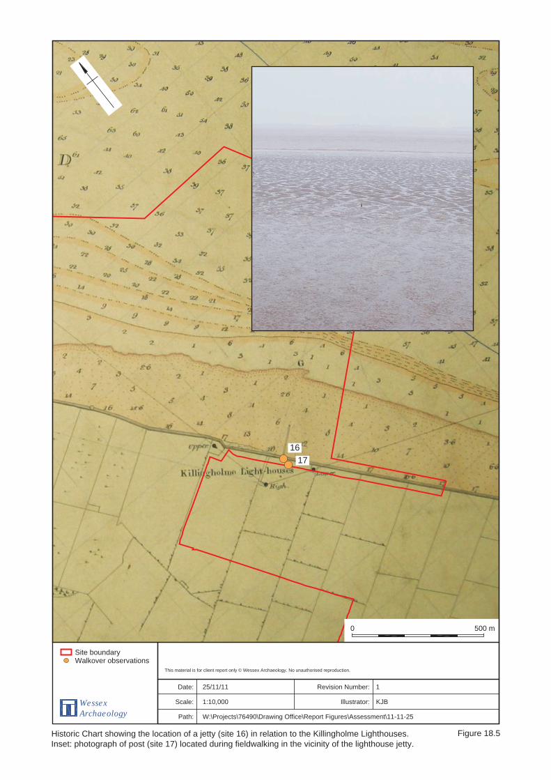
16 - 517959 418268 Cartographic
Evidence
1855 Ordnance Survey map shows a jetty north of
‘Killingholme Lt Ho No 2’. The 1887 OS map shows the jetty
to be immediately east of the Killingholme High
lighthouse. The jetty continues to be marked on the OS
maps until 1956 where no jetty is marked, but a number of
piles are marked on the map in the foreshore where the
jetty used to be.
Post-
Medieval to
Modern
None B
17 - 517959 418238 Monument One post was seen on the foreshore east of the Killingholme
High lighthouse, thought to be possible remains of site 16.
Unknown None C
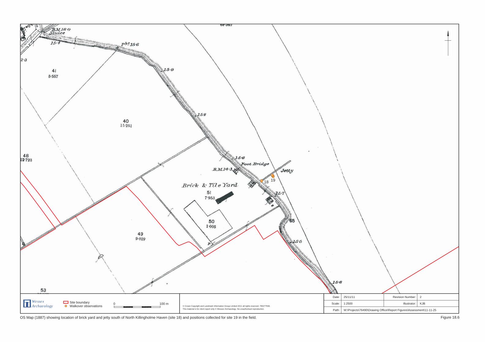
18 MLS20136 517000 419690 Cartographic
evidence
Brick and tile yard to the south of North Killingholme
Haven first appears on the OS maps in 1887. The brick and
tile yard is served by a jetty on the foreshore and a
footbridge. The brick and tile yard, and associated jetty, are
recorded on OS maps through to 1910 but do not appear on
the 1932 map.
Post-
Medieval to
Modern
None C
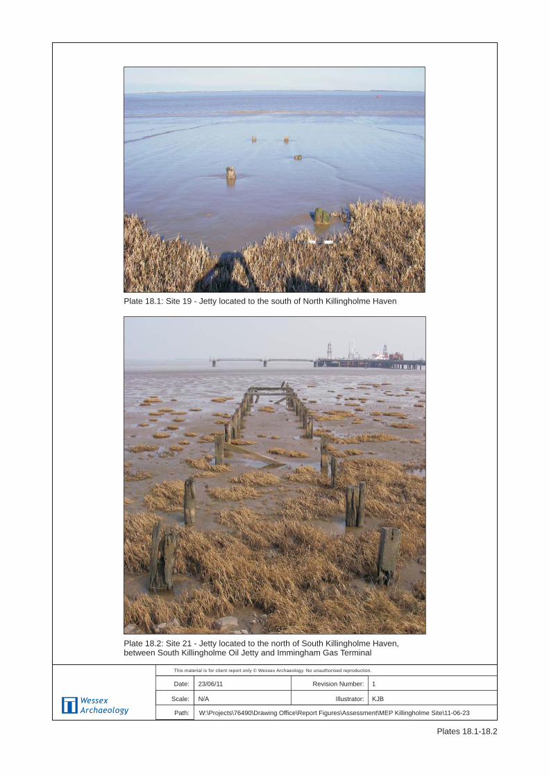
19 -
517024 419701
Monument Jetty remains located next to the reed bed extending
towards the river at on a bearing of 60° for an estimated
length of 7m. The spacing between the two closest timbers
is 1.75m and the jetty seems to narrow slightly along its
length. A total of 6 posts were visible above the mud
upstanding to a height of around 0.25m. Possibly the
remains of site 18.
Unknown None C
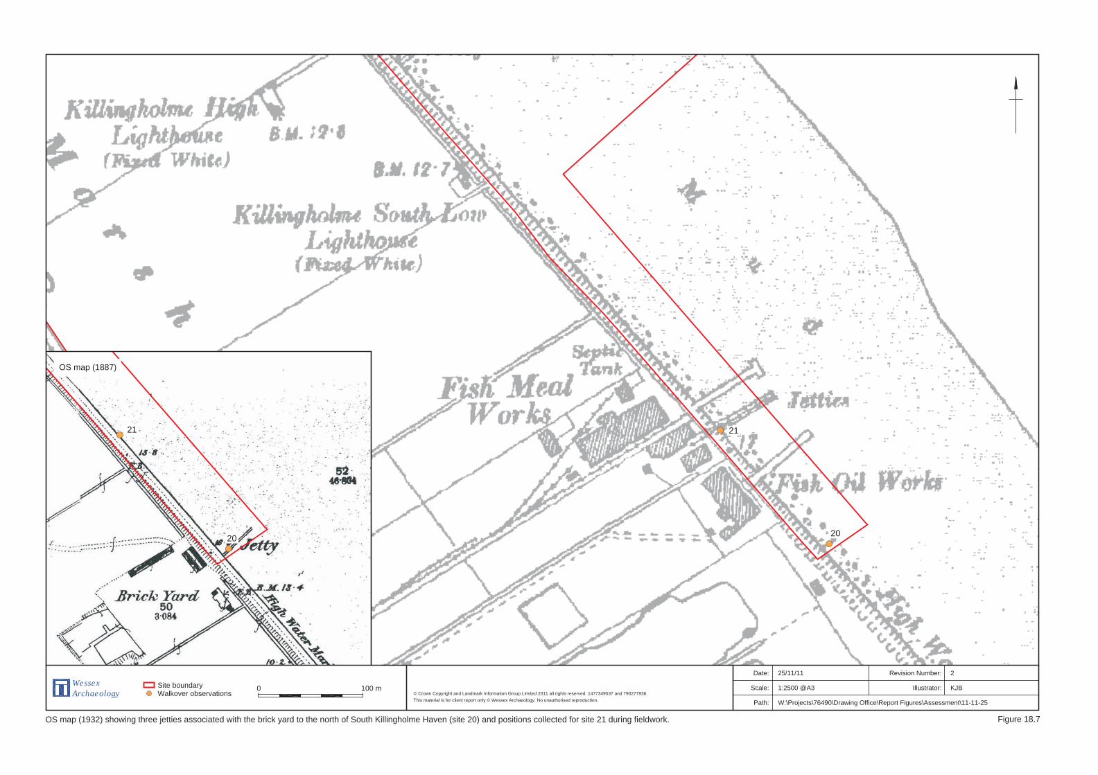
20 - 518357 417802 Cartographic
evidence
Brick yard and jetty marked on the 1887 OS map to the
north of South Killingholme Haven. A second jetty is added
at the brick works by 1908 and by 1932 the site has been
converted to a fish meal and fish oil works. The fish
Post-
medieval to
Modern
None C
Page 21
ENVIRONMENTAL RESOURCES MANAGEMENT ABLE UK
18-21
Site
No
HER/NMR
Reference
Easting Northing Form/Type Description Period Designation Significance
processing site has three jetties in 1932 but only one by
1951. The OS map for 1956 records no jetties at the site.
21 -
518253 417911
Monument Jetty remains extend approximately 40m from the sea wall
on a bearing of 54°. A total of 12 pairs of piles remain
upstanding, two pairs have their cross beams still intact,
and a further six individual piles have lost their pair. The
jetty timbers measure approximately 30cm by 30cm and
stand around 1.2m high. The jetty is approximately 3.6m
wide, with pile spacings of around 2.6m. Possibly remains
of Site 20.
Unknown None C
22 MLS 20123
NMR
943015
517860 418560
Wreck IVY, English Ketch, built 1874, recorded wrecked 1897
whilst on a fishing trip. Owner: J Munby, Master: E J Barth,
Crew: 5. Vessel foundered and was lost following a
collision with the Goole registered SS Corea. Location
unknown.
Post-
Medieval
None C
23 NMR
943096
517860 418560
Wreck WILLIAM, English Sloop Built 1883 recorded wrecked
1899. Owner: W Marshall & Sons, Grimsby, Master: J Ball,
Crew: 2. Vessel foundered and was lost following collision
with the Hull registered steam trawler ORINOCO. Location
unknown.
Post-
Medieval
None C
24 NMR
907861
UKHO
8510
517858 418559 Wreck SERGEI, Hull built screw steamer built 1899 wrecked after
a collision, whilst en route from Malmo to Hull with pit
props in 1923. The ship was raised and broken up 1923,
however dispersal operations still on-going through to
October 1924. UKHO provides alternative position 518697,
418548, which lies 40m outside of the MEP.
Modern None C
Page 22
ENVIRONMENTAL RESOURCES MANAGEMENT ABLE UK
18-22
Site
No
HER/NMR
Reference
Easting Northing Form/Type Description Period Designation Significance
25 NMR
907862
UKHO
8511
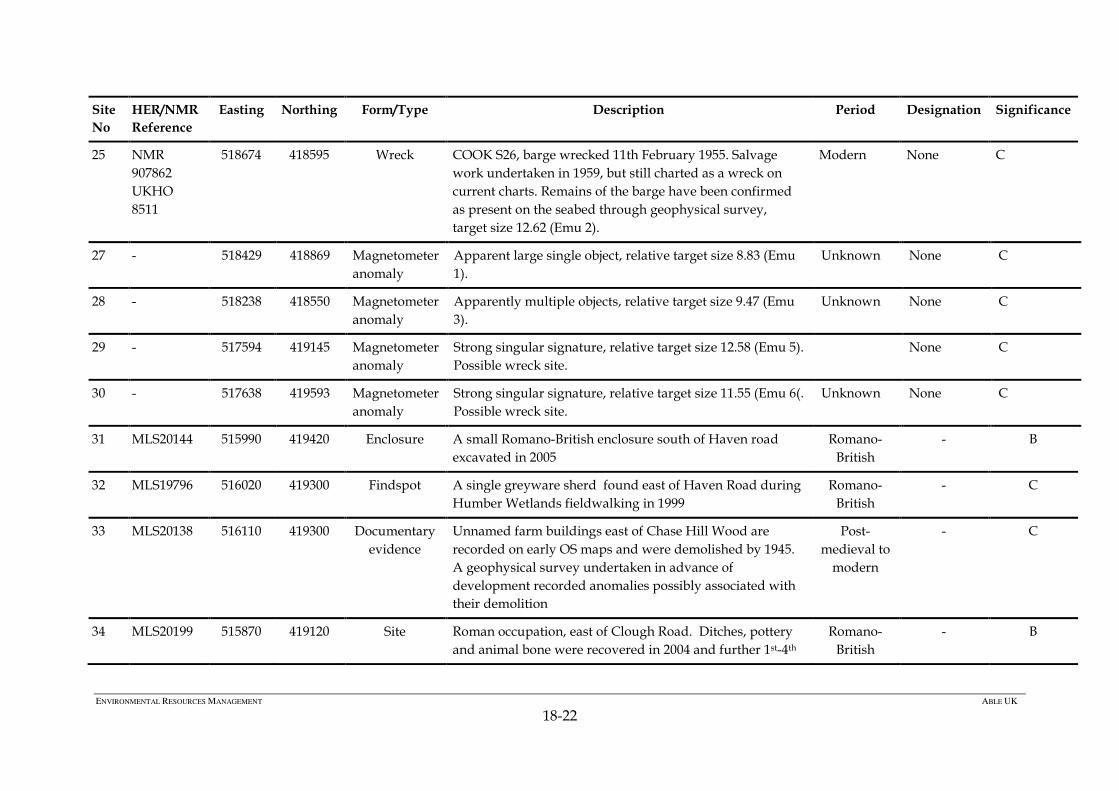
518674 418595 Wreck COOK S26, barge wrecked 11th February 1955. Salvage
work undertaken in 1959, but still charted as a wreck on
current charts. Remains of the barge have been confirmed
as present on the seabed through geophysical survey,
target size 12.62 (Emu 2).
Modern None C
27 - 518429 418869 Magnetometer
anomaly
Apparent large single object, relative target size 8.83 (Emu
1).
Unknown None C
28 - 518238 418550 Magnetometer
anomaly
Apparently multiple objects, relative target size 9.47 (Emu
3).
Unknown None C
29 - 517594 419145 Magnetometer
anomaly
Strong singular signature, relative target size 12.58 (Emu 5).
Possible wreck site.
None C
30 - 517638 419593 Magnetometer
anomaly
Strong singular signature, relative target size 11.55 (Emu 6(.
Possible wreck site.
Unknown None C
31 MLS20144 515990 419420 Enclosure A small Romano-British enclosure south of Haven road
excavated in 2005
Romano-
British
- B
32 MLS19796 516020 419300 Findspot A single greyware sherd found east of Haven Road during
Humber Wetlands fieldwalking in 1999
Romano-
British
- C
33 MLS20138 516110 419300 Documentary
evidence
Unnamed farm buildings east of Chase Hill Wood are
recorded on early OS maps and were demolished by 1945.
A geophysical survey undertaken in advance of
development recorded anomalies possibly associated with
their demolition
Post-
medieval to
modern
- C
34 MLS20199 515870 419120 Site Roman occupation, east of Clough Road. Ditches, pottery
and animal bone were recovered in 2004 and further 1st-4th
Romano-
British
- B
Page 23
ENVIRONMENTAL RESOURCES MANAGEMENT ABLE UK
18-23
Site
No
HER/NMR
Reference
Easting Northing Form/Type Description Period Designation Significance
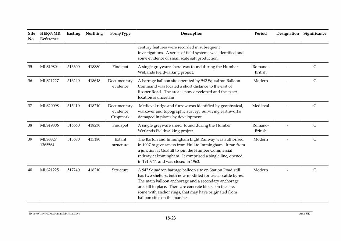
century features were recorded in subsequent
investigations. A series of field systems was identified and
some evidence of small scale salt production.
35 MLS19804 516600 418880 Findspot A single greyware sherd was found during the Humber
Wetlands Fieldwalking project.
Romano-
British
- C
36 MLS21227 516240 418648 Documentary
evidence
A barrage balloon site operated by 942 Squadron Balloon
Command was located a short distance to the east of
Rosper Road. The area is now developed and the exact
location is uncertain
Modern - C
37 MLS20098 515410 418210 Documentary
evidence
Cropmark
Medieval ridge and furrow was identified by geophysical,
walkover and topographic survey. Surviving earthworks
damaged in places by development
Medieval - C
38 MLS19806 516660 418230 Findspot A single greyware sherd found during the Humber
Wetlands Fieldwalking project
Romano-
British
- C
39 MLS8827
1365564
513680 415180 Extant
structure
The Barton and Immingham Light Railway was authorised
in 1907 to give access from Hull to Immingham. It ran from
a junction at Goxhill to join the Humber Commercial
railway at Immingham. It comprised a single line, opened
in 1910/11 and was closed in 1963.
Modern - C
40 MLS21225 517240 418210 Structure A 942 Squadron barrage balloon site on Station Road still
has two shelters, both now modified for use as cattle byres.
The main balloon anchorage and a secondary anchorage
are still in place. There are concrete blocks on the site,
some with anchor rings, that may have originated from
balloon sites on the marshes
Modern - C
Page 24
ENVIRONMENTAL RESOURCES MANAGEMENT ABLE UK
18-24
Site
No
HER/NMR
Reference
Easting Northing Form/Type Description Period Designation Significance
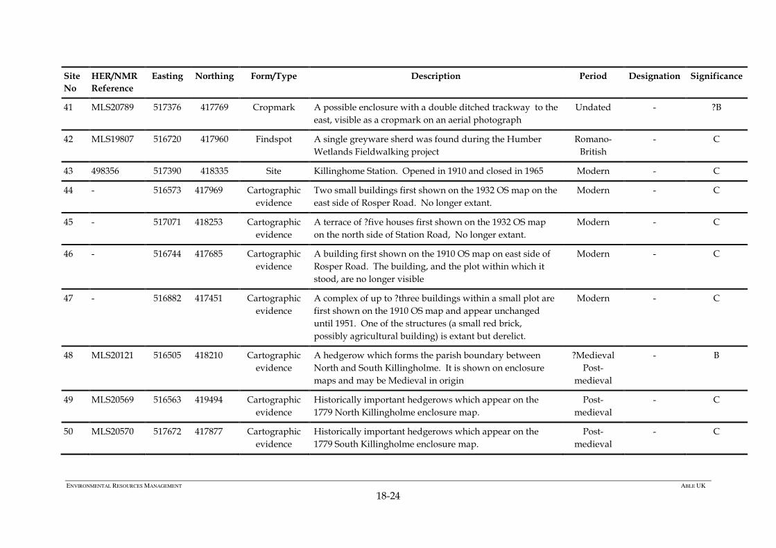
41 MLS20789 517376 417769 Cropmark A possible enclosure with a double ditched trackway to the
east, visible as a cropmark on an aerial photograph
Undated - ?B
42 MLS19807 516720 417960 Findspot A single greyware sherd was found during the Humber
Wetlands Fieldwalking project
Romano-
British
- C
43 498356 517390 418335 Site Killinghome Station. Opened in 1910 and closed in 1965 Modern - C
44 - 516573 417969 Cartographic
evidence
Two small buildings first shown on the 1932 OS map on the
east side of Rosper Road. No longer extant.
Modern - C
45 - 517071 418253 Cartographic
evidence
A terrace of ?five houses first shown on the 1932 OS map
on the north side of Station Road, No longer extant.
Modern - C
46 - 516744 417685 Cartographic
evidence
A building first shown on the 1910 OS map on east side of
Rosper Road. The building, and the plot within which it
stood, are no longer visible
Modern - C
47 - 516882 417451 Cartographic
evidence
A complex of up to ?three buildings within a small plot are
first shown on the 1910 OS map and appear unchanged
until 1951. One of the structures (a small red brick,
possibly agricultural building) is extant but derelict.
Modern - C
48 MLS20121 516505 418210 Cartographic
evidence
A hedgerow which forms the parish boundary between
North and South Killingholme. It is shown on enclosure
maps and may be Medieval in origin
?Medieval
Post-
medieval
- B
49 MLS20569 516563 419494 Cartographic
evidence
Historically important hedgerows which appear on the
1779 North Killingholme enclosure map.
Post-
medieval
- C
50 MLS20570 517672 417877 Cartographic
evidence
Historically important hedgerows which appear on the
1779 South Killingholme enclosure map.
Post-
medieval
- C
Page 25
ENVIRONMENTAL RESOURCES MANAGEMENT ABLE UK
18-25
Site
No
HER/NMR
Reference
Easting Northing Form/Type Description Period Designation Significance
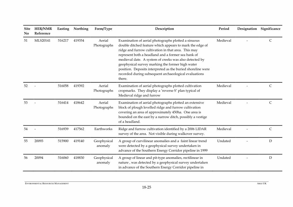
51 MLS20141 516217 419354 Aerial
Photographs
Examination of aerial photographs plotted a sinuous
double ditched feature which appears to mark the edge of
ridge and furrow cultivation in that area. This may
represent both a headland and a former sea bank of
medieval date. A system of creeks was also detected by
geophysical survey marking the former high water
position. Deposits interpreted as the buried shoreline were
recorded during subsequent archaeological evaluations
there.
Medieval - C
52 - 516058 419392 Aerial
Photographs
Examination of aerial photographs plotted cultivation
cropmarks. They display a ‘reverse S’ plan typical of
Medieval ridge and furrow
Medieval - C
53 - 516414 418642 Aerial
Photographs
Examination of aerial photographs plotted an extensive
block of plough levelled ridge and furrow cultivation
covering an area of approximately 450ha. One area is
bounded on the east by a narrow ditch, possibly a vestige
of a headland.
Medieval - C
54 - 516939 417562 Earthworks Ridge and furrow cultivation identified by a 2006 LIDAR
survey of the area. Not visible during walkover survey.
Medieval - C
55 20093 515900 419140 Geophysical
anomaly
A group of curvilinear anomalies and a faint linear trend
were detected by a geophysical survey undertaken in
advance of the Southern Energy Corridor pipeline in 1999
Undated - D
56 20094 516060 418830 Geophysical
anomaly
A group of linear and pit-type anomalies, rectilinear in
nature , was detected by a geophysical survey undertaken
in advance of the Southern Energy Corridor pipeline in
Undated - D
Page 26
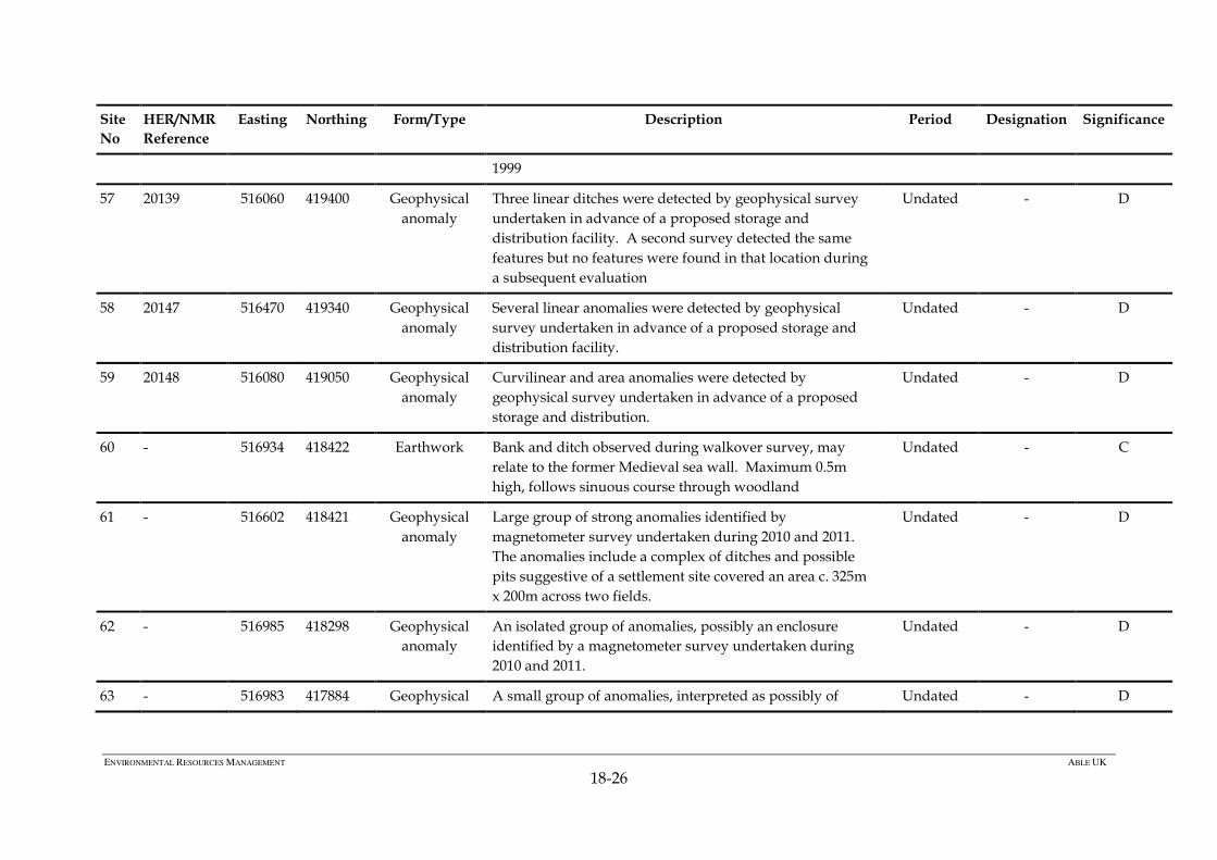
ENVIRONMENTAL RESOURCES MANAGEMENT ABLE UK
18-26
Site
No
HER/NMR
Reference
Easting Northing Form/Type Description Period Designation Significance
1999
57 20139 516060 419400 Geophysical
anomaly
Three linear ditches were detected by geophysical survey
undertaken in advance of a proposed storage and
distribution facility. A second survey detected the same
features but no features were found in that location during
a subsequent evaluation
Undated - D
58 20147 516470 419340 Geophysical
anomaly
Several linear anomalies were detected by geophysical
survey undertaken in advance of a proposed storage and
distribution facility.
Undated - D
59 20148 516080 419050 Geophysical
anomaly
Curvilinear and area anomalies were detected by
geophysical survey undertaken in advance of a proposed
storage and distribution.
Undated - D
60 - 516934 418422 Earthwork Bank and ditch observed during walkover survey, may
relate to the former Medieval sea wall. Maximum 0.5m
high, follows sinuous course through woodland
Undated - C
61 - 516602 418421 Geophysical
anomaly
Large group of strong anomalies identified by
magnetometer survey undertaken during 2010 and 2011.
The anomalies include a complex of ditches and possible
pits suggestive of a settlement site covered an area c. 325m
x 200m across two fields.
Undated - D
62 - 516985 418298 Geophysical
anomaly
An isolated group of anomalies, possibly an enclosure
identified by a magnetometer survey undertaken during
2010 and 2011.
Undated - D
63 - 516983 417884 Geophysical A small group of anomalies, interpreted as possibly of Undated - D
Page 27
ENVIRONMENTAL RESOURCES MANAGEMENT ABLE UK
18-27
Site
No
HER/NMR
Reference
Easting Northing Form/Type Description Period Designation Significance
anomaly archaeological origin, identified by a magnetometer survey
undertaken during 2010 and 2011.
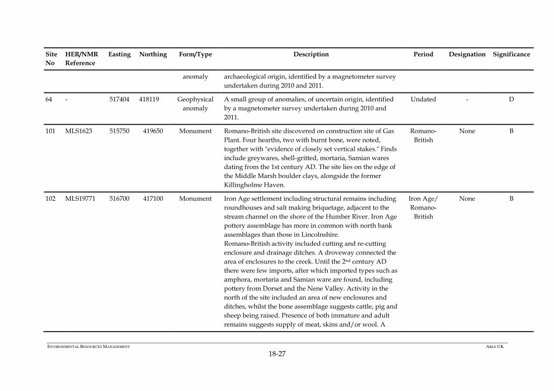
64 - 517404 418119 Geophysical
anomaly
A small group of anomalies, of uncertain origin, identified
by a magnetometer survey undertaken during 2010 and
2011.
Undated - D
101 MLS1623 515750 419650 Monument Romano-British site discovered on construction site of Gas
Plant. Four hearths, two with burnt bone, were noted,
together with "evidence of closely set vertical stakes." Finds
include greywares, shell-gritted, mortaria, Samian wares
dating from the 1st century AD. The site lies on the edge of
the Middle Marsh boulder clays, alongside the former
Killingholme Haven.
Romano-
British
None B
102 MLS19771 516700 417100 Monument Iron Age settlement including structural remains including
roundhouses and salt making briquetage, adjacent to the
stream channel on the shore of the Humber River. Iron Age
pottery assemblage has more in common with north bank
assemblages than those in Lincolnshire.
Romano-British activity included cutting and re-cutting
enclosure and drainage ditches. A droveway connected the
area of enclosures to the creek. Until the 2nd century AD
there were few imports, after which imported types such as
amphora, mortaria and Samian ware are found, including
pottery from Dorset and the Nene Valley. Activity in the
north of the site included an area of new enclosures and
ditches, whilst the bone assemblage suggests cattle, pig and
sheep being raised. Presence of both immature and adult
remains suggests supply of meat, skins and/or wool. A
Iron Age/
Romano-
British
None B
Page 28
ENVIRONMENTAL RESOURCES MANAGEMENT ABLE UK
18-28
Site
No
HER/NMR
Reference
Easting Northing Form/Type Description Period Designation Significance
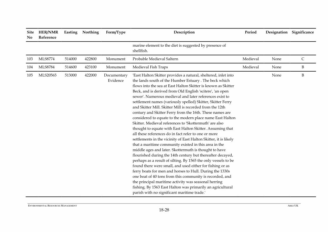
marine element to the diet is suggested by presence of
shellfish.
103 MLS8774 514000 422800 Monument Probable Medieval Saltern Medieval None C
104 MLS8784 514600 423100 Monument Medieval Fish Traps Medieval None B
105 MLS20565 513000 422000 Documentary
Evidence
'East Halton Skitter provides a natural, sheltered, inlet into
the lands south of the Humber Estuary . The beck which
flows into the sea at East Halton Skitter is known as Skitter
Beck, and is derived from Old English 'scitere', 'an open
sewer'. Numerous medieval and later references exist to
settlement names (variously spelled) Skitter, Skitter Ferry
and Skitter Mill. Skitter Mill is recorded from the 12th
century and Skitter Ferry from the 16th. These names are
considered to equate to the modern place name East Halton
Skitter. Medieval references to 'Skottermuth' are also
thought to equate with East Halton Skitter. Assuming that
all these references do in fact refer to one or more
settlements in the vicinity of East Halton Skitter, it is likely
that a maritime community existed in this area in the
middle ages and later. Skottermuth is thought to have
flourished during the 14th century but thereafter decayed,
perhaps as a result of silting. By 1565 the only vessels to be
found there were small, and used either for fishing or as
ferry boats for men and horses to Hull. During the 1330s
one boat of 40 tons from this community is recorded, and
the principal maritime activity was seasonal herring
fishing. By 1563 East Halton was primarily an agricultural
parish with no significant maritime trade.'
None B
Page 29
ENVIRONMENTAL RESOURCES MANAGEMENT ABLE UK
18-29
Site
No
HER/NMR
Reference
Easting Northing Form/Type Description Period Designation Significance
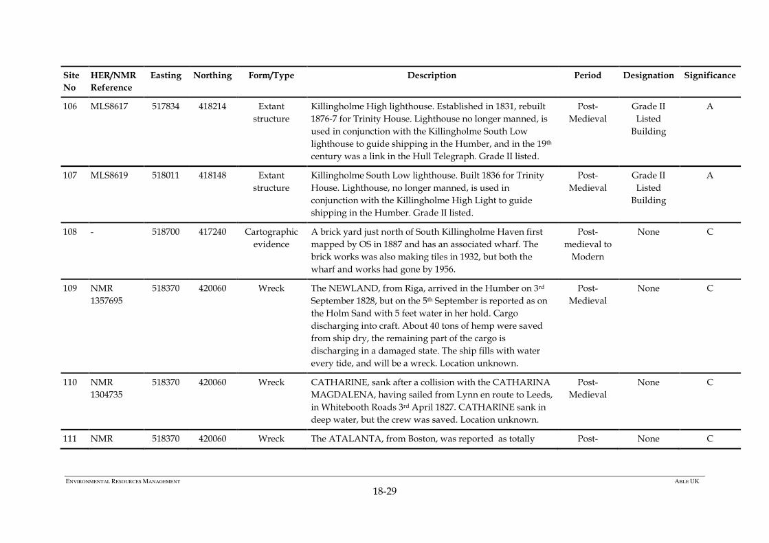
106 MLS8617 517834 418214 Extant
structure
Killingholme High lighthouse. Established in 1831, rebuilt
1876-7 for Trinity House. Lighthouse no longer manned, is
used in conjunction with the Killingholme South Low
lighthouse to guide shipping in the Humber, and in the 19th
century was a link in the Hull Telegraph. Grade II listed.
Post-
Medieval
Grade II
Listed
Building
A
107 MLS8619 518011 418148 Extant
structure
Killingholme South Low lighthouse. Built 1836 for Trinity
House. Lighthouse, no longer manned, is used in
conjunction with the Killingholme High Light to guide
shipping in the Humber. Grade II listed.
Post-
Medieval
Grade II
Listed
Building
A
108 - 518700 417240 Cartographic
evidence
A brick yard just north of South Killingholme Haven first
mapped by OS in 1887 and has an associated wharf. The
brick works was also making tiles in 1932, but both the
wharf and works had gone by 1956.
Post-
medieval to
Modern
None C
109
NMR
1357695
518370 420060 Wreck The NEWLAND, from Riga, arrived in the Humber on 3rd
September 1828, but on the 5th September is reported as on
the Holm Sand with 5 feet water in her hold. Cargo
discharging into craft. About 40 tons of hemp were saved
from ship dry, the remaining part of the cargo is
discharging in a damaged state. The ship fills with water
every tide, and will be a wreck. Location unknown.
Post-
Medieval
None C
110 NMR
1304735
518370 420060 Wreck CATHARINE, sank after a collision with the CATHARINA
MAGDALENA, having sailed from Lynn en route to Leeds,
in Whitebooth Roads 3rd April 1827. CATHARINE sank in
deep water, but the crew was saved. Location unknown.
Post-
Medieval
None C
111 NMR 518370 420060 Wreck The ATALANTA, from Boston, was reported as totally Post- None C
Page 30
ENVIRONMENTAL RESOURCES MANAGEMENT ABLE UK
18-30
Site
No
HER/NMR
Reference
Easting Northing Form/Type Description Period Designation Significance
1358152 wrecked on the sands above Hull on 19th March 1831. Crew
drowned. NB: The `sands' are not identified, there being
several possible candidates, and the named location of
"Offshore Killingholme", covering Foul Holme Spit, has
been chosen by NMR for convenience. Location unknown.
Medieval
112 NMR
1431654
518370 420060 Wreck 2nd September 1833 wreck of the British registered wooden
sailing vessel FAIRY was reported stranded on Holme Spit
during a gale, while en route from Newcastle-upon-Tyne to
Gainsborough. Location unknown.
Post-
Medieval
None C
113 NMR
943144
UKHO
66989
520110 416760 Wreck SINGAPORE, screw steamer built in Hull 1900, wrecked off
Immingham following a collision with HM Scout class
cruiser ADVENTURE, which was at anchor in the Humber
in 1920. SINGAPORE was owned by the Hull Sea Fishing
and Ice Co., and was a registered trawler (No.H505).
UKHO provide additional positions which they highlight
as unreliable, lying 3.8km NW of the NMR position at
517936, 419921.
Modern None C
114 UKHO
8514
517200 420676 Wreck ALEXANDRA, tug wrecked off Killingholme Oil Jetty 15th
March 1920. Site no longer charted on 3rd May 1920 and
amended to a lift site, suggesting recovery of the vessel.
Modern None C
115 UKHO
66984
518601 418329 Wreck Pile driving frame sunk at the end of a jetty during
construction works in June 1955. The site was salvaged by
the owners in July 1955
Modern None D
116 MLS8195
NMR
516480 420050 Monument Killingholme Battery was built to defend the port of
Killingholme on the Humber estuary. It opened between
Modern None C
Page 31
ENVIRONMENTAL RESOURCES MANAGEMENT ABLE UK
18-31
Site
No
HER/NMR
Reference
Easting Northing Form/Type Description Period Designation Significance
1321225
(NMR
1473796)
1915-1916 and by February 1916 was armed with two
quick-firing 12 pounder guns emplaced on two octagonal
concrete towers. The guns were removed in 1919 and the
site was disused in 1926. Two 6-pounder Hotchkiss guns,
one 1-pounder gun on a Naval carriage, and one 1-pounder
gun on a travelling carriage are recorded as in place in
1916, with a 12-pounder 12-hundredweight gun listed in
1917.
The battery was demolished in 1998 and surveyed before
and during demolition.
117 MLS15395 516200 420200 Monument The North Killingholme Royal Naval oil depot may have
been established just before the outbreak of the First World
War. It consisted of 35 steel tanks, each about 24m diameter
and clad in a protective outer skin of brick, with steel mesh
and concrete within the cavity. All tanks now demolished.
Modern None C
118 MLS21205 516063 420776 Monument NAS Killingholme opened in 1914 and was operated
initially by the Royal Naval Air Service and later the US
Navy, closing in 1919. Large numbers of aircraft were
based at the station, intercepting Zeppelins, carrying out
marine patrols and training. At the height of the war 46
seaplanes operated from NAS Killingholme. A converted
paddle steamer seaplane carrier, pressed into service as
HMS Killingholme, was also based here.
Modern None B
119 - 516099 420727 Monument Composite (wood and metal) slipway possibly associated
with NAS Killingholme (site 118).
None B
120 MLS21233 515262 421309 Monument WW2 barrage balloon anchorage site, Winters Lane. Modern None C
Page 32
ENVIRONMENTAL RESOURCES MANAGEMENT ABLE UK
18-32
Site
No
HER/NMR
Reference
Easting Northing Form/Type Description Period Designation Significance
121 MLS21226 518496 416977 Monument WW2 barrage balloon anchorage site, north of Humber
Road.
Modern None C
122 NMR
1341163
520110 416760 Documentary
evidence
Handley Page Halifax Mk. III heavy bomber; one of a batch
of 360 delivered between March and August 1944,
Squadron 10. Two engines feathered; ditched off
Immingham 28th October 1944. Location unknown
Modern None A
123 - 517260 419740 Monument Possible Jetty located at the low water line extending into
the river. The site was not accessible during the walkover
survey due to extremely soft muds, and the position has
been estimated. Photographic recording shows at least 14
piles remaining, upstanding to around 0.3m. The piles are
aligned roughly 45° to the river at low water and at least six
pairs of piles remain, with additional individual timbers.
No further interpretation/significance assessment is
possible without closer examination.
Unknown None B/C
124 - 516978 419746 Monument Linear alignment of 5 unworked wooden posts roughly
0.04m diameter, surviving to an average height of 0.30m.
Orientated east-west eroding out of the reed bank towards
the river. Total length approximately 0.7m.
Unknown None B/C
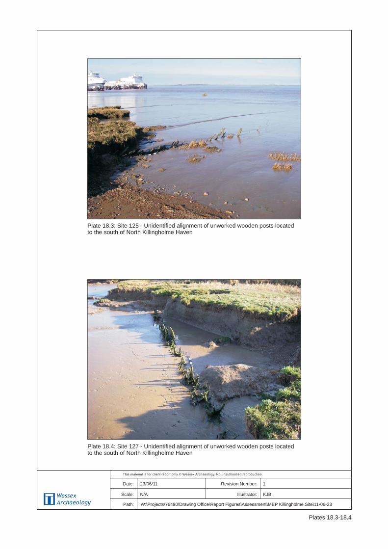
125 - 516970 419782 Monument Linear alignment of 24 unworked wooden posts roughly
0.04m diameter, surviving to an average height of 0.30m.
Total length approximately >8m. Orientated east-west
eroding out of the reed bank towards the river.
Unknown None B/C
126 - 516950 419808 Monument Linear alignment of unworked wooden posts roughly
0.04m diameter, surviving to an average height of 0.30m. T
Unknown None B/C
Page 33
ENVIRONMENTAL RESOURCES MANAGEMENT ABLE UK
18-33
Site
No
HER/NMR
Reference
Easting Northing Form/Type Description Period Designation Significance
shaped with 2.1m orientated 80º and 2m orientated 320 º.
Eroding out of the reed bank parallel to the river.
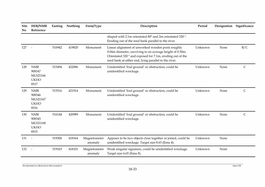
127 - 516942 419820 Monument Linear alignment of unworked wooden posts roughly
0.04m diameter, surviving to an average height of 0.30m.
Orientated 320 º and exposed for 7.1m, eroding out of the
reed bank at either end, lying parallel to the river.
Unknown None B/C
128 NMR
908347
MLS21166
UKHO
8517
515494 422086 Monument Unidentified ‘foul ground’ or obstruction, could be
unidentified wreckage.
Unknown None C
129 NMR
908346
MLS21167
UKHO
8516
515516 421914 Monument Unidentified ‘foul ground’ or obstruction, could be
unidentified wreckage.
Unknown None C
130 NMR
908345
MLS21168
UKHO
8515
516144 420989 Monument Unidentified ‘foul ground’ or obstruction, could be
unidentified wreckage.
Unknown None C
131 - 519306 418164 Magnetometer
anomaly
Appears to be two objects close together or joined, could be
unidentified wreckage. Target size 8.63 (Emu 4).
Unknown None
132 - 519165 418101 Magnetometer
anomaly
Weak singular signature, could be unidentified wreckage.
Target size 6.65 (Emu 8).
Unknown None
Page 34
ENVIRONMENTAL RESOURCES MANAGEMENT ABLE UK
18-34
Site
No
HER/NMR
Reference
Easting Northing Form/Type Description Period Designation Significance
133 - 519556 417856 Magnetometer
anomaly
Strong singular signature, could be unidentified wreckage.
Target size 10.4 (Emu 9).
Unknown None
134 MLS18476 516000 420700 Cartographic
evidence
Site of Killingholme gun battery, dismantled 1824. Post-
Medieval
None C
135 MLS20085 514090 422529 Artefact
Scatter
During excavations at East Halton Skitter by Northern
Archaeology Associates in 2000, a total of 84 stuck pieces of
flint were recovered from 11 trenches. Nearly all were
manufactured from local till flint. The assemblage
comprised 5 cores, 8 chunks and chippings, 45 flakes, 5
blades and bladelets, 4 edge utilised flakes, 1 edge utilised
blade, 5 miscellaneous retouched flakes, 2 miscellaneous
retouched chunks, 4 edge retouched flakes, 1 edge
retouched blade, 1 notched flake, and 3 scrapers.
One scraper is an extended end scraper of the 'Beaker'
period, one core is a seven platformed blade core of
early/middle Neolithic character, and some of the flakes
are similar to those used in the manufacture of late
Neolithic arrowheads. A middle Neolithic to early Bronze
Age date is likely for the bulk of the material, with a
slightly greater emphasis on the Bronze Age. The
assemblage is clearly residual, originating mainly from the
primary fills of the Romano-British ditches. Any potential
flint scatters are likely to be the products of isolated
occupation, or small knapping events. This site was listed
in a desk-based assessment carried out by AC Archaeology
in 2006. No additional information.
Early
Neolithic to
Early
Bronze Age
None B/C
136 MLS19798 515880 419700 Findspot Four flint flakes were recovered during the Humber Prehistoric - C
Page 35
ENVIRONMENTAL RESOURCES MANAGEMENT ABLE UK
18-35
Site
No
HER/NMR
Reference
Easting Northing Form/Type Description Period Designation Significance
Wetlands Fieldwalking project.
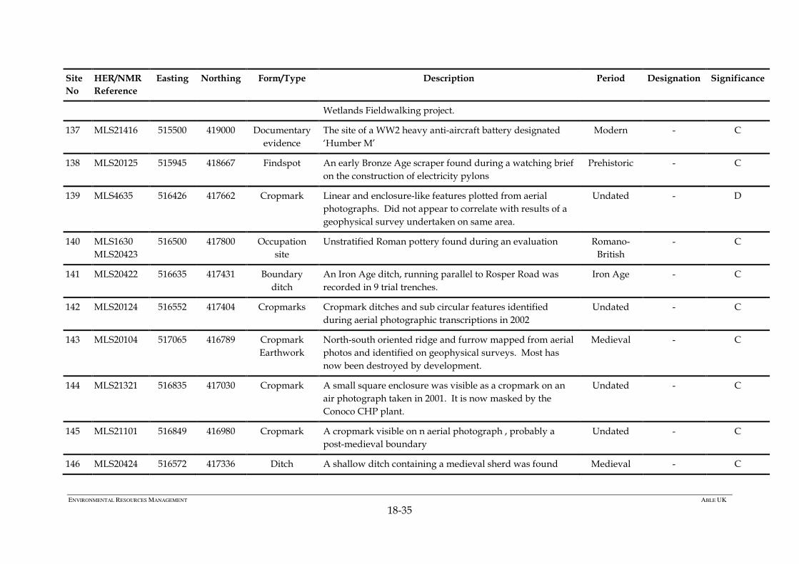
137 MLS21416 515500 419000 Documentary
evidence
The site of a WW2 heavy anti-aircraft battery designated
‘Humber M’
Modern - C
138 MLS20125 515945 418667 Findspot An early Bronze Age scraper found during a watching brief
on the construction of electricity pylons
Prehistoric - C
139 MLS4635 516426 417662 Cropmark Linear and enclosure-like features plotted from aerial
photographs. Did not appear to correlate with results of a
geophysical survey undertaken on same area.
Undated - D
140 MLS1630
MLS20423
516500 417800 Occupation
site
Unstratified Roman pottery found during an evaluation Romano-
British
- C
141 MLS20422 516635 417431 Boundary
ditch
An Iron Age ditch, running parallel to Rosper Road was
recorded in 9 trial trenches.
Iron Age
- C
142 MLS20124 516552 417404 Cropmarks Cropmark ditches and sub circular features identified
during aerial photographic transcriptions in 2002
Undated - C
143 MLS20104 517065 416789 Cropmark
Earthwork
North-south oriented ridge and furrow mapped from aerial
photos and identified on geophysical surveys. Most has
now been destroyed by development.
Medieval - C
144 MLS21321 516835 417030 Cropmark A small square enclosure was visible as a cropmark on an
air photograph taken in 2001. It is now masked by the
Conoco CHP plant.
Undated - C
145 MLS21101 516849 416980 Cropmark A cropmark visible on n aerial photograph , probably a
post-medieval boundary
Undated - C
146 MLS20424 516572 417336 Ditch A shallow ditch containing a medieval sherd was found Medieval - C
Page 36
ENVIRONMENTAL RESOURCES MANAGEMENT ABLE UK
18-36
Site
No
HER/NMR
Reference
Easting Northing Form/Type Description Period Designation Significance
during an evaluation in 2006
147 MLS21322 517300 417000 Cropmark A T-shaped arrangement of ditches is visible on wartime
aerial photographs. They were dug as aircraft landing
obstructions and were mostly levelled sometime after the
war.
Modern - C
148 MLS21323 517440 417370 Documentary
evidence
Earthwork
Aerial photographs taken in 1941 showed a row of about 16
terraced houses to the south of Marsh Lane. OS maps
suggest they were built between 1902 and 1932 and had
been demolished by 1975. Low earthworks were still
visible on the site in 2008
Modern - C
149 MLS21324 517630 417500 Documentary
evidence
Marsh Farm is shown on the first edition OS map of 1887.
It was demolished at some time after 1945
Post-
medieval
- C
150 MLS21335 515900 419450 Ditch An archaeological evaluation carried out in 2009 identified
ditches dating from the late 2nd and early 3rd centuries AD
Romano-
British
- C
151 Earthwork Ridge and furrow cultivation earthworks recorded within
Chase Hill Wood and Fox Covert during a LIDAR survey
undertaken in 2006
Medieval - C
152 ELS2729 Earthwork Ridge and furrow cultivation earthworks identified within
Burkinshaw’s covert and in woodland to the south during
LIDAR survey undertaken in 2006. This extensive area was
partially recorded subsequently by a topographic survey
and watching brief within the covert (E23)
Medieval - C
153 MLS20098 515410 418210 Documentary Medieval ridge and furrow was identified by geophysical, Medieval - C
Page 37
ENVIRONMENTAL RESOURCES MANAGEMENT ABLE UK
18-37
Site
No
HER/NMR
Reference
Easting Northing Form/Type Description Period Designation Significance
evidence
Cropmark
walkover and topographic survey. Surviving earthworks
damaged in places by development
154 MLS11775 515460 418810 Cropmark Faint rectangular feature noted on air photographs. Not
confirmed by geophysical survey
Undated - D
155 MLS1496 515300 419900 Settlement Romano-British settlement site, north of the former site of
Chase Hill Farm, excavated in 1990 and 2008
Romano-
British
- B
156 MLS17461 515350 420150 Enclosure Rectangular enclosure recognised as a cropmark on aerial
photographs, subsequently excavated and dated as Late
Iron Age to 2nd - 3rd century
Iron Age-
Romano-
British
- C
157 MLS21458 515080 420180 Monument A linear and a curvilinear feature were excavated and
found to be of Middle Iron Age to Romano-British date
Iron Age-
Romano-
British
- C
158 MLS20090 515270 420080 Geophysical
anomaly
Geophysical anomalies, including a possible ring ditch,
recorded in 1999. Subsequent excavations found no
archaeological features.
Undated - D
159 MLS21459 515370 420030 Ditch A ditch and curvilinear gully were recorded during a trial
trench evaluation
Iron Age-
Romano-
British
- C
160 MLS17472 514900 420700 Cropmark Cropmarks of a ploughed out linear earthwork. Appears to
be a ridge and furrow headland that may also have had a
sea defence function.
Undated - C
161 MLS20567 514000 421000 Hedge Group of historically important hedgerows Post-
medieval
- C
Page 38
ENVIRONMENTAL RESOURCES MANAGEMENT ABLE UK
18-38
Site
No
HER/NMR
Reference
Easting Northing Form/Type Description Period Designation Significance
162 MLS20135 514990 419510 Hedge The boundary between East Halton and North
Killingholme parishes, formerly known as Meergate hedge,
dates from before 1850
Post-
medieval
- B
163 MLS21326 514800 416900 Railway The Humber Commercial Railway was constructed in 1912
to link the eastern jetty at Immingham Dock with the main
Grimsby - New Holland line at Ulceby
Modern - C
164 MLS20570 517000 417000 Hedge Group of historically important hedgerows Post-
medieval
- C
165 ELS2650 515678 420334 Field
evaluation
Two undated linear features were identified during trial
trenching in advance of development of land.
Undated - C
166 MLS10746 514500 420900 Earthwork Areas of ridge and furrow cultivation, appearing as both
earthworks and cropmarks in East Halton parish
Medieval - C
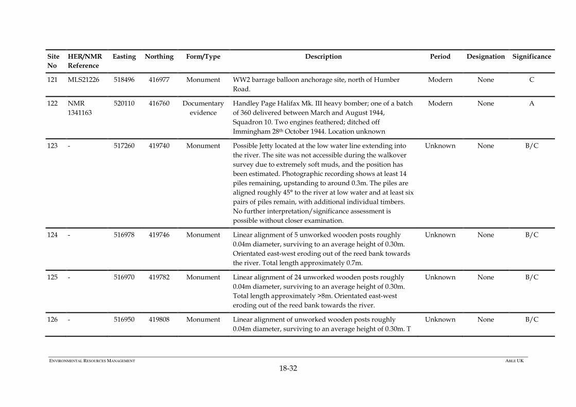
167 - 517571
419443 Magnetometer
anomaly
Apparently multiple objects, could be unidentified
wreckage. Target size 11.41 (Emu 7).
Unknown None C
Page 39
ENVIRONMENTAL RESOURCES MANAGEMENT ABLE UK
18-39
The Development of the Humber Estuary Following the Last Ice Age
18.5.6 Following the last ice age, around 8 000 bp (before present), the low
lying areas of North Lincolnshire and East Yorkshire were flooded by
rising sea water, to as much as perhaps 5m above current Ordnance
Datum. After c. 2 000 years sea-level had regressed and the Humber
Estuary was left as a recognisable topographic entity fringed by low
lying marshland giving rise to heavy, largely stone-free soils prone to
water logging. A forest of alder, oak and birch developed over the
glacial till.
18.5.7 The forest was fully established by around 6 500 bp and a lower peat
developed on the forest floor during the later Mesolithic due to a
change to a slightly wetter climate. Vibrocores collected from within
and seaward of the AMEP contained organic remains and possible
former land surfaces. VC05 recovered dark grey organic clay layers and
a piece of wood. The depth of organic remains in this core, at around
12.45m below CD (16.35m below OD) indicates possible fragments of a
preserved palaeo-land surface dating to the Mesolithic (Wessex
Archaeology, 2011).
18.5.8 A significant marine transgression during the Bronze Age laid down a
thick layer of marine clay over the peat, associated with the formation
of saltmarsh. A subsequent reduction in the rate of sea level rise, or a
marine regression, facilitated the development of freshwater marsh
identified from the deposition of a layer of Phragmites clays. The area
therefore has some potential for the presence of littoral occupation, at
intervals throughout the early prehistoric period. This may be
concentrated in areas where relatively raised land, within or adjacent
to, former marshland once offered the potential for temporary or more
permanent settlement to exploit both terrestrial and marine
environments. Elsewhere along the estuary there is proven potential
for sites of prehistoric date, beneath alluvium and where the conditions
are such that archaeological deposits (including organic remains such
as wooden track ways dating from the Bronze Age to Romano-British
period) remain preserved in situ. Vibrocores VC20 and VC21 within the
AMEP recovered organic remains and possible former land surfaces at
0.15m above and 1.22m below CD (3.75m and 5.12m below OD)
respectively, indicating the survival of land surfaces from later
prehistory.
Page 40
ENVIRONMENTAL RESOURCES MANAGEMENT ABLE UK
18-40
The Marine Energy Park
Maritime Background
18.5.9 The River Humber has a large catchment opening on to the North Sea
and has been a focus of navigation throughout history. The
archaeological potential of the AMEP in respect of maritime activity is
considerable.
18.5.10 The deepwater channel of the River Humber is close to the Lincolnshire
shore, in the vicinity of the AMEP from Immingham to North
Killingholme. As such large amounts of shipping will have passed by
the AMEP site. It can be expected that passing vessels will have been
lost in this area, whilst others may deposited shipping debris onto the
river bed either through deliberate discard or accidental loss during
passage or whilst anchored in Whitebooth Road.
18.5.11 Some maritime activity will have focussed on the local area itself,
destined for or departing from havens within the Killingholme reach
for transport, fishing and so on. These activities may have resulted in
wrecks and lost or discarded material, but could also include the
deliberate abandonment of vessels. Local maritime activity will have
resulted in various forms of infrastructure: wharves, quays, hards, boat
building and repair facilities, navigational markers and other aids, for
example.
18.5.12 Both the passing traffic and local maritime activity have a very long
history, for which there is direct evidence in the surrounding area, but
only of a later period (nineteenth century) actually within the AMEP.
From a navigational point of view, the narrow deepwater channel off
Killingholme is a pinch-point between the vast extent of navigable
rivers (and later canals) serving the Midlands and Yorkshire, and the
North Sea with its connections to the East Coast, Thames, English
Channel, Low Countries, Baltic, Scandinavia and beyond.
Documentary and archaeological evidence records the passing of
Roman pilots, Viking warriors, Medieval settlers, post-Medieval
traders, army, navy and air force personnel during both World Wars
along the Humber adjacent to the AMEP.
The Early Prehistoric Period
18.5.13 The intertidal coastline at North Killingholme consists of a broad
terrace around 6.9m to 7.9m below CD (-3m to -4m OD), dropping
steeply to a second terrace at 12.9 below CD ( -9m OD). Vibrocores have
recovered multiple instances of the presence of organic material,
Page 41
ENVIRONMENTAL RESOURCES MANAGEMENT ABLE UK
18-41
representing palaeo-land surfaces, buried by alluvial sand and clay
deposits (Figure 18.3). The distribution of the cores and organic
material do not allow for clear identification of the full extent of palaeo-
land surfaces, however the two furthest cores containing organic
material were over 1 km apart, suggesting that potentially extensive
areas of potential palaeo-land surfaces may be preserved.
18.5.14 The buried palaeo-land surfaces indicate the presence of potentially
habitable areas during periods of lower sea-level.
18.5.15 Although the earliest inhabitation of Britain stretches back at least
970,000 years (Parfitt et al 2010), the glacial tills found across the
landward part of the study area, were formed during the last
(Devensian) glaciation, which reached its maximum extent about 18,000
years ago. At this time the ice sheet probably covered the AMEP and
sea level was approximately 130m lower than today. No Devensian or
pre-Devensian archaeological material has been reported in the area, so
the potential for archaeological deposits from the Lower and Middle
Palaeolithic is not considered further.
18.5.16 The first evidence for re-occupation of northern Britain after the last Ice
Age dates to around 13,000 years ago. At this time the AMEP foreshore
would have overlooked the valley of the Humber River, but would
have been hundreds of miles distant from the sea. There are no reports
of archaeological material from the Late Upper Palaeolithic / Late
Glacial periods from the area, but its possible presence cannot be
discounted. Given that sea level was still much lower than the current
profile described above, archaeological material of this date could be
present within the sub-tidal channel of the Humber, and within the
inter-tidal area.
18.5.17 The first evidence for human occupation in the AMEP comes from a
number of flint flakes dating to the Mesolithic period (sites 1 to 10). At
this time, c. 8500 to 4000 BC, the Humber River would have been
flowing roughly within the current river valley, and the river banks,
and higher ground would have been covered with a forest of oak, alder
and birch. The Mesolithic period saw sea levels rise from around 40 m
below current to roughly similar to today. The open coast, however,
would still have been over 5km east of the present coastline and the
Humber River may not have been tidal. Some of the organic material
identified in vibrocores from the AMEP are likely to date from the later
Mesolithic period, when the sea level was at least 7 m lower than today,
and could contain well preserved archaeological evidence of land-based
activities from this period.
Page 42
ENVIRONMENTAL RESOURCES MANAGEMENT ABLE UK
18-42
18.5.18 In the ensuing periods a number of marine transgressions and
regressions have been identified, resulting in the foreshore and
immediately adjacent low lying areas becoming sequentially flooded
then re-exposed . The salt and freshwater marshes that formed in the
area would have provided a variety of food sources. Artefacts
recovered from the AMEP (sites 1 and 11) and to the north (sites 135,
136 and 138) dating to the Neolithic through to the Bronze Age c. 2400
to 700 BC, illustrate the presence of people in the area at this time.
18.5.19 In addition to land based activities, a number of well preserved boat
finds from the Humber Basin at Ferriby, Kilnsea and Brigg (McGrail,
2004: 184) illustrate that the local population was using the River
possibly for fishing, fowling and transport of goods and people. These
boats, both sewn planked and logboats were all flat bottomed and
would not have required significant infrastructure. It is likely that
boats could have been launched and beached on shallow shelving
shorelines, with easy access to the hinterland settlements. The
sediments of the Humber foreshore have demonstrated their suitability
for the preservation of prehistoric wooden boat remains, and the
possibility exists that the buried foreshore deposits in the AMEP could
preserve such evidence.
Iron Age and Romano-British Period
18.5.20 Evidence for Iron Age (c. 700 BC to AD 43) settlement has been found
within the AMEP (sites 12 and 13) along with evidence nearby for salt
production, boat use and riverine travel. A large Spilsby Sandstone
object was found during excavations of the Iron Age settlement within
the AMEP (site 13) and has been tentatively identified as an anchor for
a small boat, based on a similar, smaller object of the same stone found
at the Roman Fort at Caister on Sea. Boats from this period continued
the earlier Bronze Age construction traditions, with both a logboat and
a flat bottomed sewn plank boat, or raft dating to the Iron Age, found in
the Humber river basin at Brigg (McGrail 2004: 184).
18.5.21 The Iron Age settlement sites within the AMEP (sites 12 and 13) were
located either side of a narrow coastal inlet, providing the inhabitants
with easy, sheltered access to the River. There is a high likelihood that
the Iron Age inhabitants would have had access to boats and regularly
used the River to access other communities or fishing grounds, for
example. Whilst no boat remains were identified during previous
excavations at the sites, the waterlogged alluvial deposits would be
suitable for preserving such wooden remains.
18.5.22 Iron Age settlement outside the AMEP (site 102) was located on the
edge of the inlet and occupied in several distinct phases from the early
Page 43
ENVIRONMENTAL RESOURCES MANAGEMENT ABLE UK
18-43
Iron Age when small scale salt production or storage was being
undertaken. Following a brief hiatus, which may coincide with a period
of inundation, the site was reoccupied during the late Iron Age on
slightly higher ground to the north. A large boundary ditch (site 141)
and drainage features may be associated with this.
18.5.23 Geophysical surveys recently undertaken within the AMEP have
identified an extensive area of anomalies including a complex of ditches
and pits (site 61) a possible enclosure (site 62) and further anomalies
(sites 63 and 64). These lie to the southeast of site 13, close to the former
shore, and are of probable later prehistoric date.
18.5.24 The Roman army is recorded to have arrived on the South Bank of the
Humber in AD 43, where they halted, consolidated control in the south
before crossing the River in AD 71 to complete the conquest of Britain
(Humberside Archaeology Unit 1992: 3).
18.5.25 Continuation of settlement from the Iron Age through to the Roman
occupation (AD 43 to 410) is evident at the settlement site excavated
within the AMEP (site 13). Imported Roman pottery recovered from
within, and close to the AMEP (sites 13, 101 and 102) provides a
glimpse of the national and international trading networks established
at this time between northern Britain and the Continent. Other
imported luxury ‘Roman’ items such as glassware, wine and olive oil
amphora have all been found in the Humberside area, highlighting the
maritime links with the Roman empire (Humberside Archaeology Unit
1992: 9).
18.5.26 The hazardous task of navigating the Humber by boat is shown by the
employment of pilots, one of whom records his service with the 6th
legion when he set up an altar in York (Humberside Archaeology Unit
1992: 9). It is thought that the process of transferring goods and people
from seagoing ships to smaller ships and boats suitable for navigating
the Humber and its estuaries would have required the use of many
small harbours and ports along the estuary. A number of potential
harbour locations have been suggested, but none have yet been
identified in the archaeological record.
18.5.27 Activity at an occupation site to the south west of the AMEP (site 102),
adjacent to the stream channel, included the creation of a droveway
between the settlement and creek, indicating the potential use of the
creek, with its natural inlet off the Humber River, as source of
transportation and communication with nearby settlements. The River
would also have provided a rich source of food through fishing,
fowling and collection of shellfish. Very few remains of Romano-
Page 44
ENVIRONMENTAL RESOURCES MANAGEMENT ABLE UK
18-44
British period boats have been found in Britain, the best examples
coming from the Thames in central London, but none have been
recovered from the Humber Basin.
18.5.28 No evidence of activity from this period has yet been found along the
Humber foreshore, however, excavations to the south at
Stallingborough recovered evidence of crop-processing and enclosures
and ditches dating to the late 3rd and 4th century AD, possibly
associated with salt making or pottery production. There was no
evidence of flooding events in this area, suggesting that by the late
Romano-British period the sea level had stabilised at current levels and
the coastal fringes were suitable for permanent settlement and farming.
18.5.29 Evidence of agricultural settlement from the Iron Age through the
Romano-British period has been identified within the AMEP (sites 31
and 34) and immediately outside it (sites 101, 150, 155, 156, 157 and
159). The settlement activity may have been associated with small scale
salt production but equally it may represent an outlying part of the
Chase Hill complex, an extensive Romano-British ladder settlement to
the north-west. Isolated sherds of Roman pottery (sites 32, 35, 38 and
42) have been recovered from higher ground within the AMEP. Despite
the obvious difficulties of living on the edge of marginal land, the level
of Romano-British settlement in this area is probably fairly intensive.
The Saxon Period
18.5.30 There is no archaeological evidence for continued occupation or use of
the immediate coastal area around Killingholme in the Anglo-Saxon
Period (AD 410 to 1066), although the name Killingholme is believed to
date to this period, and a number of important Anglo-Saxon cemeteries
have been excavated from the broader area.
18.5.31 Documentary evidence describes the arrival of the Angles and Frisian
settlers in the area, followed by Scandinavians. Imported Frankish
pottery has been found to the north of the AMEP dating to the middle-
Saxon period (Bryant, 1994: 49), a small insight to the developing links
with the Low Countries and northern Germany. The maritime links
with the Baltic and Scandinavia increased during this period, with
Scandinavian war parties arriving by ship in the Humber followed by
Viking raiders and settlers. The strong cultural and trading links
developed during this period between the Humber region, Scandinavia
and the Baltic formed the basis of trading patterns for ports such as
York and Hull through to the nineteenth century.
Page 45
ENVIRONMENTAL RESOURCES MANAGEMENT ABLE UK
18-45
18.5.32 Although ship building technology was continuing to develop, ships
were still built with flat bottoms allowing them to be drawn up on
beaches. This approach has left little evidence of harbours and ports.
Whilst it seems that settlements were concentrated on higher ground
during this period, it is possible that the creek identified with the
AMEP was still navigable, and that the inlet could have continued to
provide a sheltered landing area for boats. Cultural links across the
North Sea are demonstrated by the boat burials at Sutton Hoo and
Snape in Suffolk, which not only mirrored the Scandinavian burial
tradition, but also demonstrated similar boat building traditions
(McGrail 2004: 210). A tenth century ship from a tidal creek of the
Thames demonstrates a continuation of Romano-British construction
techniques (McGrail 2004: 218) , however no ships dating to the Anglo-
Saxon period have been found in the Humber basin.
18.5.33 There is no evidence for settlement within or outside the AMEP for this
period but a quantity of fifth century pottery recovered during
excavations at Chase Hill Farm may be significant.
The Medieval Period
18.5.34 The majority of evidence for occupation and exploitation of the AMEP
in the Medieval period (AD 1066 to 1540) comes from earthworks and
cropmarks representing extensive agricultural activity, including
enclosures and field systems typical of Medieval ridge and furrow
cultivation. Riverside activity in the broader area is demonstrated by
salt works and a possible fish trap to the north of the AMEP (sites 103
and 104). The salt workings expanded the marshes eastward, and left
accumulated debris landward of the marshes. Through the Medieval
period, the salt working debris became covered with estuarine alluvium
and eventually became suitable for pasture.
18.5.35 Despite documentary evidence attesting to the importance of the
Humber for access to inland regions in the Medieval period (Childs,
1990), very little archaeological evidence has been found locally to
illustrate the types of boats and ships in use on the river.
18.5.36 One example of the importance of the Humber as a navigation route
includes the arrival of Harold Hadrada, King of Norway with a fleet of
300 ships in the Humber estuary in 1066, from where he fought and
defeated the Earls of Northumbria and Mercia with the aid of Tostig
(brother of King Harold II of England) and Scottish allies (Humberside
Archaeology Unit 1991). A second fleet was sent up the Humber by the
King of Denmark in 1069 to assist a rebellion in Yorkshire against
Page 46
ENVIRONMENTAL RESOURCES MANAGEMENT ABLE UK
18-46
William, Duke of Normandy’s claim to the English throne (Humberside
Archaeology Unit 1991).
18.5.37 Maritime trade flourished in the Humber through the twelfth and
thirteenth centuries with major ports at Beverley and Hedon exporting
wool and cloth to London, the Low Countries and the Baltic (Childs,
1990). By 1400 Hull was the third busiest port in England, with imports
of wood, iron, wool, olive oil, spices, silk, fruit and wine from
Scandinavia, the Baltic, Spain, Portugal, Italy and France (Humberside
Archaeology Unit, 1991: 22). In addition to this international trade, the
Humber and its tributaries would have been a major route for transport
and communication between settlements within the Humber basin. It is
likely that in addition to the major ports, there would have been smaller
local beach markets and that river side settlements would have had
access to a sheltered ‘haven’. The suspected Medieval port at East
Halton Skitter (site 105) to the north of the AMEP is one example of a
smaller harbour site, thought to also have been a ferry crossing point. It
is possible that the havens at North and South Killingholme may have
served a similar function.
18.5.38 Whilst no direct evidence for early infrastructure has been found
archaeologically at these havens, those still in use, such as Stone Creek
on the north bank of the Humber, illustrates the shelter they can
provide for small ships and boats. By comparison, remains of Hull’s
medieval waterfront, dated to c.1325, have been located surviving to a
height of over 3m (Humberside Archaeology Unit, 1991: 22). No
archaeological examples of boats and ships have been located in the
Humber from this date, but it is likely that there would have been a
variety of vessels on the river during this period, including logboats,
Baltic ‘cogs’, Nordic and Mediterranean style cargo ships and local
vernacular Humber Keels (McGrail, 2004). Whilst the size of cargo
ships is recorded as increasing throughout the medieval period, there
would still have been a need for small boats for transhipment and local
travel (Childs, 1990: 23).
18.5.39 The villages of North and South Killingholme are classic ‘row’ villages,
extending along a north-south spine road. They developed on the
slightly higher ground of Middle Marsh and the place-name evidence
suggests that they were established by the eleventh century. Although
the detailed topography of the pre-enclosure landscape cannot be
recovered, its general principles are clear, not only from later maps, but
also from documents, particularly a 1585 survey of East Halton and
Killingholme with eighteenth century transcription and a late
eighteenth century farm sale brochure. The village cultivated large
tracts of arable in a two open field system, East and West fields, which
Page 47
ENVIRONMENTAL RESOURCES MANAGEMENT ABLE UK
18-47
were separated by the spine road along which the farmsteads and other
dwellings lay. No medieval settlement has been found within the
AMEP. An isolated sherd of pottery has been recorded to the west (site
146) but no features were associated with it.
18.5.40 Three principal areas of cultivation have been identified within the
AMEP (sites 37, 52, 53 and 54), all of which display a ‘reverse S’ plan
typical of Medieval ridge and furrow cultivation. Site 143 is a
continuation of this cultivation. Site 51, a sinuous double ditched
feature also identified from aerial photographs, appears to mark the
eastern extent of ridge and furrow cultivation and may represent both a
headland and a former sea bank of medieval date. Further ridge and
furrow earthworks have been identified to the north and west of the
AMEP (sites 151, 152, 153 and 166). There are no well-preserved ridge
and furrow earthworks in the application area.
18.5.41 All the medieval cultivation remains are located just around (or above)
the 4m contour and rarely extend into the edge of the alluvium. This
corresponds with the pre-enclosure map depicting the use of higher
ground for cultivation and the lower lying saltmarsh appearing to be
unusable or more suited to summer pasture. The hedgerow forming the
parish boundary between North and South Killingholme (site 48) is
shown on enclosure map of 1776-79 and may be Medieval in origin.
The Post-Medieval Period
18.5.42 Historic charts dating to 1821 (UKHO E135) and 1841 (Admiralty Chart
109 Edition A) support suggestions that shipping along the Humber
continued in a similar approach to that during the Medieval period,
with the use of small havens and hillside churches as navigation aids.
Sailing directions dating to 1780 (Collins 1780) describe the safe sailing
passage up the Humber in the vicinity of the AMEP, using buoys and
transits off churches. He describes the locations and depths of the
channels and the location of the sandbanks and flats. The anchorage of
Whitebooth Roads, off Killingholme, is named by Collins in 1780 and
described as a mile above Foul Holme Sands and ‘the best Road in the
Humber’. This description supports the suggestion that there may have
been only limited availability of formal harbours and anchorages at this
time. It also suggests that as the best anchorage in the Humber, it
would have been heavily used and a focus for shipping in this stretch of
the river. As with all historic anchorages, the potential exists for
archaeological remains on the seabed within this area. The seabed at
historic anchorages often contains ship-borne debris thrown overboard
from ships at anchor, including ceramics, glass or ship related fixtures
and fittings. In addition, it is not uncommon to find abandoned
mooring anchors within historic anchorages, whilst remains of ships
Page 48
ENVIRONMENTAL RESOURCES MANAGEMENT ABLE UK
18-48
that wrecked at anchor, usually during storms are also known.
Whitebooth Road was formally marked as an anchorage on the 1912
Admiralty Chart (AC109 Edition D). The unidentified magnetic
anomalies identified during geophysical survey of the AMEP (EMU
2010) could represent wreck or debris associated with the historic use of
Whitebooth Roads (sites 26-30, 131-133).
18.5.43 Levels of shipping on the Humber increased steadily as politics at home
and overseas enabled the expansion of trading links, and the
accumulation of wealth and maritime skills in the area. Hull had
developed into one of England’s major ports by the 1700s and became
one of the two major ports serving the needs of the Industrial
Revolution, its rate of growth exceeded only by Liverpool. It was only
with the development of steam engines and the telegraph in the mid
nineteenth century, however, that shipping and the Humber riverside
took on a more industrial than medieval look, with the construction of
docks, wharves and warehouses in the late eighteenth century (Davis,
1978). In addition to the construction of docks in Hull, navigation aids
and havens were established all along the Humber to ensure continued
safe passage of ships and cargoes. The construction of the Killingholme
High lighthouse (site 106) in 1831 marks the beginning of formalised
navigation aids in the stretch of river adjacent to the AMEP.
18.5.44 The Killingholme High lighthouse (site 106) was the first of three
lighthouses built in the area. The Killingholme South Low lighthouse
(site 107) was built in 1836 and lined up with the High lighthouse to
mark the safe channel past Grimsby towards Killingholme (Figure 18.4).
A third lighthouse, Killingholme North Low (site 15), was constructed
in 1851 and aligned with the High lighthouse to mark the channel past
Foul Holme Sand to Paull. All three lighthouses were important to safe
navigation on the Humber and are protected as Grade II listed
buildings. Records of seven wreck incidents to the south of the AMEP
between 1810 and 1915 attest to the difficulty of navigating this stretch
of river, with two ships sunk as a result of collision, and the importance
of the lighthouses to safe navigation at this time.
18.5.45 An 1851/52 chart (UKHO L9005) and the 1855 Ordnance Survey (OS)
map show a jetty (site 16) between the Killingholme High and
Killingholme South Low lighthouses (Figure 18.5). The jetty continues to
be marked on charts and maps until the 1956 OS map, when only a
number of piles are marked in the foreshore where the jetty used to be.
No obvious remains of this jetty were located during the walkover
survey, however one solitary post (site 17) was seen on the foreshore
close to the High lighthouse, which may be the remnants of the jetty.
There is the potential for further timbers to be present within the thick
mud in this area
Page 49
ENVIRONMENTAL RESOURCES MANAGEMENT ABLE UK
18-49
18.5.46 Three brick yards are marked on the historic OS maps between North
Killingholme Haven and South Killingholme Haven. The brick and tile
yard to the south of North Killingholme Haven (site 18) first appears on
the OS maps in 1887 (Figure 18.6), served by a jetty on the foreshore and
a footbridge. The brick and tile yard, and associated jetty, are recorded
on OS maps through to 1910 but do not appear on the 1932 map. The
brick yard and jetty are marked on the 1912 published chart for the area
(AC 109 edition D) but not on earlier charts. The jetty identified during
the walkover survey in this vicinity (site 19) is likely to be the remains
of this brick and tile yard jetty. Site 19 is located next to the reed bed
extending towards the river at on a bearing of 60° for an estimated
length of 7 m (Plate 18.1). The spacing between the two closest timbers
is 1.75 m and the jetty seems to narrow slightly along its length. A total
of 6 posts were visible above the mud upstanding to a height of around
0.25 m.
18.5.47 A second brick yard and jetty is marked on the 1887 OS map to the
north of South Killingholme Haven (site 20). A second jetty was added
at the brick works by 1908 and by 1932 the site has been converted to a
fish meal and fish oil works. The fish processing site had three jetties in
1932 but only one in 1951. By 1956 there no jetties are mapped at the
site although the fish meal works are. It is likely that site 21, which was
identified during the walkover survey (Figure 18.7), is the remains of a
jetty associated with the brick yard or fish meal works. Site 21 is located
between South Killingholme Oil Jetty and Immingham Gas Terminal.
(plate 18.2) and extends approximately 40m from the sea wall on a
bearing of 54°. A total of 12 pairs of piles remain upstanding, two pairs
have their cross beams still intact, and a further six individual piles
have lost their pair. The jetty timbers measure approximately 30cm by
30cm and stand around 1.2 m high. The jetty is approximately 3.6m
wide, with pile spacings of around 2.6m along the jetty. A number of
large jetty timbers of similar dimensions were observed washed up on
the foreshore of the river, and may have come from this jetty.
18.5.48 A third brick yard is mapped just north of South Killingholme Haven
(site 108), to the south of the AMEP boundary. This site is first mapped
by OS in 1887 and has an associated wharf. The brick works was also
making tiles in 1932, but both the wharf and works had gone by 1956.
The wharf area and foreshore at South Killingholme Haven has been
infilled and is now occupied by storage yards.
18.5.49 Work elsewhere on the Humber has noted that Humberside brickworks
were built close to construction and development sites, particularly
around Hull (J. Tibbles pers comm). There are few buildings in the
Killingholme marsh area in the late nineteenth century so this
Page 50
ENVIRONMENTAL RESOURCES MANAGEMENT ABLE UK
18-50
observation is not supported here. It is possible, however that the bricks
were used for seawall defences in the absence of local stone, or in later
years the construction of the Immingham light railway. The presence of
small jetties next to the brick works could suggest, alternatively, that
the bricks were destined for the major construction works elsewhere on
the River, such as the construction of the Hull Docks in the 1880s.
18.5.50 The two brickwork jetties and one lighthouse jetty identified on historic
maps as within the AMEP suggest that there would have been a
reasonable amount of local boat traffic in the area. The relatively small
size of the jetties indicate that small ships or boats were in use rather
than larger cargo vessels more usually associated with late nineteenth
century shipping.
18.5.51 The difficulties of navigating the stretch of river close to the AMEP is
highlighted by two ships recorded as wrecking within the AMEP area
in the late 1890s, Ivy (1897) and William (1899) (sites 21 and 22)
although neither has been located. Information suggests both these
ships were sailing vessels, possibly wooden hulled, which sank after
collisions with steamships. The records do not indicate any salvage
work taking place, and it is possible that the damage to the ships was
extensive and resulted in complete wrecking and sinking of the ships.
If this were the case, it is entirely possible that remains of the wooden
hulls and potentially also cargo, fixtures and fittings could survive
within the anaerobic muds of the Humber seabed. A further four ships
are recorded as wrecking within 1km of the AMEP between 1826 and
1833 (sites 109, 110, 111 and 112). Two are reported to have wrecked on
the Foul Home Sands within the Humber and the fourth (site 110) sank
in Whitebooth Roads after a collision. None of these wrecks have been
located, however it is possible, as with those above (sites 21 and 22) that
remains could exist within the soft anaerobic sediments of the Humber.
18.5.52 Although no wrecks from this period are charted by the UKHO within
the AMEP or study area, this need not mean that no wrecks are present.
The UKHO records and Admiralty charts focus on the identification of
wrecks that may cause a hazard to navigation, which are
predominantly upstanding features. The wrecks reported on Holme
Sands and Holme Spit (sites 109, 112) may not have been marked on the
navigation charts as wooden vessels can often become quickly buried in
soft mud, and therefore pose no additional navigation hazard than the
sands themselves. In many cases salvaging of both cargo and upper
sections of the hull structure takes place, leaving only lower timbers,
and as is illustrated below salvaged vessels are usually removed from
charts when they are no longer a navigational hazard. This does not,
however, mean that nothing of the vessel remains on the seabed, and it
Page 51
ENVIRONMENTAL RESOURCES MANAGEMENT ABLE UK
18-51
has been found that the remains of salvaged shipwrecks can be
preserved. Soft muds and sand shoals are excellent preservation
environments for wooden shipwrecks, and there have been instances in
recent years of substantial wooden wrecks of archaeological importance
being discovered as a result of development work, despite being in
areas subject to regular hydrographic survey. The Gresham Ship (Auer
& Firth 2007) and Swash Channel wreck (Wessex Archaeology 2005)
were both located on the edge of major shipping channels, in the
Thames Estuary and outside of Poole harbour respectively. Both these
sites were located after channel dredging took place nearby, which
affected the sedimentation regimes in the area causing the sites to erode
from the edge of the channel. Both sites comprised large sections of hull
structure in good condition and a numerous and varied artefact
assemblage.
18.5.53 The Ordnance survey map for 1824 and Admiralty Chart for the area
dated 1841 record a dismantled ‘2 Gun Battery’ (site 134) to the north of
Killingholme Haven. Paull battery on the north side of the Humber
was re-built in 1808 as part of the Humber Napoleonic defences and
dismantled in 1822, and it is possible that the Killingholme battery was
also part of the Humber defences constructed during the Napoleonic
Wars, although no further information about the site has been found.
18.5.54 The current Palmerston fort at Paull was constructed in 1861-4 and used
up until the start of the First World War. A note on the 1912 Admiralty
Chart indicates that Paull Fort was still undertaking artillery practice at
this time, and that live rounds would be fired within an area reaching
south beyond North Killingholme Haven. This same chart also notes
the potential for explosives within the anchorage at North Killingholme
Haven. It is possible that some of the magnetometer anomalies
identified within the AMEP (sites 26-30) could be related to unexploded
ordnance associated with either Killingholme or Paull Battery. Shells
found in the course of dredging activities in the Thames dating to the
nineteenth and early twentieth centuries have proved to be of
archaeological and historical interest.
18.5.55 The agricultural landscape of North and South Killingholme was
radically altered by Parliamentary enclosure, which was imposed
between 1776 and 1779. The open fields and common grazing land of
the Medieval villages was enclosed and allocated to private
landholders. This was often accompanied by large scale drainage
works allowing areas of former marshland to be drained and used for
arable cultivation. The straightening of the drains running through the
application area was probably undertaken during this period. The
planting of field hedges also occurred at this time and a number of
Page 52
ENVIRONMENTAL RESOURCES MANAGEMENT ABLE UK
18-52
hedgerows survive within the AMEP that appear to have been
established at the time of enclosure (sites 49 and 50). Further historic
hedgerows from this time survive outside the AMEP (sites 161 and
164), including that forming the parish boundary between East Halton
and North Killingholme (site 162).
18.5.56 An unnamed farm complex (site 33) and Marsh Farm (site 149) are
shown on early Ordnance Survey maps but no longer survive.
The Modern Period
18.5.57 OS mapping for the early twentieth century shows that whilst the
construction of Immingham Docks in 1912 and the light railway
dramatically changed the landscape inland of the docks (PEIR
Paragraph 18.5.27) the foreshore to the north of South Killingholme
Haven remained relatively unchanged.
18.5.58 The continued presence, and presumably use of the jetties at the
brickyards (sites 18 and 20) and serving the lighthouses (site 15)
suggests some local shipping activity within the AMEP through to the
early 1950s. The continued difficulty of navigating the stretch of water
off Killingholme is provided by a relatively small number of wrecks
located within and around the AMEP by the UKHO. These wrecks
provide an insight into the range of shipping in the Humber in the early
twentieth century with an example of a cargo ship continuing the
timber trade from the Baltic (site 24), fishing vessels (site 113) and
harbour work vessels (sites 114 and 25). The wrecks close to the AMEP
include two Hull built ships, the cargo steamship Sergei (site 24) built in
1899 and lost in 1923 and the steam trawler Singapore (site 113) built in
1900 and lost in 1920. There is little recorded information about the two
work vessels the tug Alexandra (site 114) lost 1920 and the barge Cook
S26 (site 25) lost in 1955. In addition to these shipwrecks, the UKHO
record the loss of a pile driving frame (site 115) highlighting that
shipwrecks are not the only archaeological sites to be found
underwater, particularly along coastlines and rivers which have been
developed and industrialised. The surviving remains of Cook 26,
identified during magnetometer surveys (EMU 2010) highlight that
although documentary records may suggest a wreck has been salvaged,
parts of the wreck or structure often remain in or on the seabed.
18.5.59 The Humber region was subject to air raids in both WW1 and WW2,
which resulted in losses to aircraft on both sides. During WW1 the
main threat was from Zeppelins, which focused raids on Hull and
Goole, as well as pressing further inland. The Humber region has a
large number of anti-aircraft defences, ranging from bombing decoys to
Page 53
ENVIRONMENTAL RESOURCES MANAGEMENT ABLE UK
18-53
armed batteries and pillboxes. A First World War heavy anti aircraft
battery is recorded at Killingholme Marshes, lying just to the north of
the AMEP (site 116). In addition to defensive structures, strategic
military installations, including the North Killingholme Royal Naval oil
storage depot (site 117) and a major seaplane base Naval Air Station
(NAS) Killingholme (site 118) were constructed within the study area.
NAS Killingholme opened in 1914 and was operated by the Royal
Naval Air Service and later the US Navy, closing in 1919. Large
numbers of aircraft were based at the station, intercepting Zeppelins
and carrying out marine patrols. The station was situated in East
Halton marsh in an area now occupied by the vehicle distribution site.
The remains of a slipway likely to be associated with NAS Killingholme
are still visible in the intertidal area to the north of the AMEP (site 119).
Records of aircraft losses in WW1 are generally very poor, and any
remains from losses associated with NAS Killingholme are likely to be
slight, buried and may not have yet been identified in geophysical
surveys. Any remains would be subject to automatic protection under
the Protection of Military Remains Act.
18.5.60 The Humber region, and Hull particularly, suffered significant damage
during WW2 air raids. Hull was hit by 82 air raids which damaged or
destroyed around 95 percent of housing. Despite the bombs and
damage, the Hull dockyards continued to operate throughout the war.
A number of anti-aircraft sites were constructed in the vicinity of the
AMEP, including five barrage balloon anchorage sites (sites 25, 36, 40,
120 and 121 ) three of which lie within the AMEP (sites 25, 36 and 40).
A series of ‘T’ shaped ditches (site 147), dug as aircraft landing
obstacles, have been recorded and a heavy anti aircraft battery (site
137), designated ‘Humber M’ is recorded at Chase Hill Wood.
18.5.61 As a result of the numerous bombing raids throughout WW2, there is
the potential for unexploded ordnance to lie within the Humber muds
in the foreshore and underwater. The magnetometer anomalies
identified within and close to the AMEP (sites 26-30 and 131-133) could
represent unexploded ordnance.
18.5.62 Many British and German aircraft were reported lost in the Humber
area during the Second World War, however, none have been located in
the vicinity of the AMEP. The closest reported loss is a Halifax MKIII
MZ576 bomber reported lost in 1944 at a position approximately 2 km
south of the AMEP (site 122), however it should be noted that
descriptions of lost aircraft locations are notoriously inaccurate (Wessex
Archaeology 2008) and it is possible that remains could lie within the
AMEP.
Page 54
ENVIRONMENTAL RESOURCES MANAGEMENT ABLE UK
18-54
18.5.63 The construction of Immingham Docks in 1912 (following the passing
of the Humber Commercial Railway and Dock Act in 1904) led to a
period of great industrial growth in that area in the early part of the
twentieth century, transforming the former marshland. A network of
railways was opened to more readily transport goods and workers to
and from the docks at Immingham and Grimsby. The Barton and
Immingham Light Railway (site 39), which runs through the application
area, was opened in around 1910 and closed in 1963. Part of
Killingholme Station (site 43) still stands and is now a private house.
Another branch of the railway (site 163) was constructed in 1912 to link
the eastern jetty at Immingham to the main line.
18.5.64 Examination of aerial photographs and historic maps has identified a
number of former buildings within the AMEP (sites 44, 45, 46 and 47).
Of those only a single building survives, at site 47, a small red brick
building originally part of a larger complex. A row of about sixteen
houses has been identified south of Marsh Lane (site 148) but no trace
now survives
Undated Features
18.5.65 Several undated timber features were identified in the area immediately
north of the AMEP during the walkover survey. Site 123 is located at
the low water line and extends into the river. The site was not
accessible during the walkover survey due to extremely soft muds, and
the position has been estimated. Photographic recording shows at least
14 piles remaining, upstanding to around 0.3 m. The piles are aligned
roughly 45° to the river at low water and at least six pairs of piles
remain, with additional individual timbers. No further interpretation is
possible without closer examination.
18.5.66 Sites 124, 125, 126 and 127 are linear alignments of unworked wooden
posts all lying to the immediate north of the AMEP boundary. Two of
the post alignments run perpendicular to the river (sites 124 and 125)
(plate 18.3) one is parallel to the river (sites 127) (plate 18.4) and a smaller
site is T shaped with one section heading east-west and another
heading north-south. The posts are all unworked pieces of wood
roughly 0.04 m diameter, surviving to an average height of 0.30 m.
Each of the features seems to continue into the eroding reed bank and
there is potential for further remains to be preserved within the bank.
A number of potentially similar sites have been identified elsewhere in
the area at Sutton on Sea (NMR 1484850), Easington (Humber HER
MHU20513), Saltfleet (NMR 1490108, 1490107 and 1506739) and
Cleethorpes (NMR 1144478). The site at Sutton-on-Sea was described as
a wooden hurdle and dated to the late Saxon period whilst the
Page 55
ENVIRONMENTAL RESOURCES MANAGEMENT ABLE UK
18-55
Easington site is described as vertical wattles and are thought to be
prehistoric. The Saltfleet sites are regular wooden stakes thought to be
post-medieval or modern whilst the Cleethorpes site is comprised of
lines of timber stakes and interpreted as fish traps dating sometime
from the Saxon to post-Medieval period.
18.5.67 There are three UKHO records of ‘foul ground’ close to the low water
mark to the north of the AMEP (sites 128, 129 and 130). The sites could
represent wreckage either from a ship or aircraft, possibly related to the
former naval seaplane base at North Killingholme.
18.5.68 Geophysical investigations identified nine magnetometer anomalies,
one of which was identified as the remains of Cook 26 (site 25) and five
additional ones lie within the AMEP (sites 27, 28, 29, 30 and 167). Two
of the anomalies within the AMEP have magnetic signatures similar to
that of site 25, and could be previously unidentified wreck remains.
The smaller magnetic anomalies could be smaller metal wrecks, the
metal fixtures and fittings of wooden hulled, composite built ships or
other shipping debris. It is equally possible that the smaller magnetic
anomalies could be ordnance associated with the Paull Battery firing
range or from First or Second World War air raids.
18.5.69 A number of cropmark features have been identified both inside (site
41) and outside the AMEP (sites 139, 142, 144, 145, 154 and 160). No
investigation has been undertaken on these features. A further six sites
have been identified from field evaluation by geophysical survey (sites
55, 56, 57, 58, 59, 60, 158 and 165). Where subsequent investigation has
been undertaken (sites 57, 158 and 165) no dateable features were
identified.
Further Surveys
18.5.70 The baseline data presented here provides a comprehensive basis on
which to assess the effects of the AMEP development on heritage assets.
Further surveys, comprising geoarchaeological assessment, field
walking, geophysical survey and trial trenching, are proposed to allow
for a detailed programme of mitigation to be established. The
arrangements for the surveys will be set out in two Written Schemes of
Investigation, each to be agreed with EH and NLC; one for works
relating to marine interests below high water (encompassing the inter-
tidal zone), and a parallel document for terrestrial heritage interests
above high water.
Page 56
ENVIRONMENTAL RESOURCES MANAGEMENT ABLE UK
18-56
18.6 IMPACTS
Introduction
18.6.1 The degree of change to each receptor/heritage assets is considered in
text below. The assessment of overall magnitude of effect is derived
using the criteria set out in Table 18.5.
Table 18.5 Assessment of overall magnitude of impact
Magnitude
of Change
Sensitivity of Receptor
National
Significance
County/Regional
Significance
Local
Significance
Not
significant
High Major
Significance
Moderate
Significance
Moderate to
Minor
Significance
Minor
Significance
Medium Moderate
Significance
Minor to
Moderate
Significance
Minor
Significance/
Minor / No
Significance
Low Minor
Significance
Minor
Significance
Minor to No
Significance
No
Significance
None No
Significance
No Significance No
Significance
No
Significance
Construction Phase
The Supply Chain Site and Heavy Component Manufacturing Plant
18.6.2 In the case of terrestrial archaeological assets adverse direct physical
impacts may arise wherever construction- or landscaping-related
ground disturbance takes place. Both activities have the ability to
partially or totally remove buried sites or upstanding features. Topsoil
stripping alone, even where no further construction is proposed, can
allow significant damage to fragile archaeological deposits hitherto
protected by a soil cover, through compaction or rutting, if traversed by
vehicles or if covered with significant weight of infill. Even where these
effects are short term, the residual impact, after mitigation may result in
long term adverse changes to the archaeological resource. It is likely
that further archaeological deposits of local or county interest will be
recorded in future investigations and may be negatively affected by
construction activities to prepare the site for operational use. These
effects may be considered to be of Moderate to Major Significance.
Page 57
ENVIRONMENTAL RESOURCES MANAGEMENT ABLE UK
18-57
18.6.3 There will be in excess of 1m of infill following topsoil stripping, on
buried archaeological remains within the site. This weight of
overburden, and the use of heavy plant on the newly-formed surface
over a prolonged period, is considered by consultees to be too great to
allow for preservation in situ of archaeological deposits without special
engineering.
18.6.4 Adverse impacts on heritage assets may also arise through the intrusion
into the setting or appreciation of the assets; effects which may be given
equal weight in terms of current planning guidance. During the
construction phase these effects might be considered short term and
reversible, for example the use of high cranes, heavy lifting equipment
may cause vibration and noise. These are likely to be considered of
Minor or No Significance.
18.6.5 Indirect impacts which would have permanent effects on the
archaeological resource may occur, for example, on or adjacent to sites
containing waterlogged archaeological (or palaeo-environmental)
remains. In these areas any interruptions to the existing movement of
groundwater or its chemistry may cause desiccation, oxidation or
erosion of hitherto preserved organic deposits. Although the effect
could be short term, the impact could result in permanent, often
unseen, negative effects to the archaeological asset. Subject to the results
of further investigations these may be considered of Minor or No
Significance.
Table 18.6 Summary of impacts on terrestrial archaeology associated with
Construction site
IMPACT
FROM
/EFFECTS
ON
Surface
archaeological
deposits
Buried
archaeological
deposits
Buried peat or
land surfaces
Other
Heritage
assets on or
off site
Topsoil
stripping,
earthmoving
and infilling
Earthwork Site
60 or traces of
medieval ridge
and furrow
cultivation will
be removed
and lose
evidential
significance.
Minor effects
on assets of
local
significance.
Sites 61 - 64,
and other
buried remains
that may exist
within the site,
may be buried
by less than
300mm of soil
cover. Rutting
and
compaction can
occur during
soil removal.
Total removal
None identified None
identified
Page 58
ENVIRONMENTAL RESOURCES MANAGEMENT ABLE UK
18-58
IMPACT
FROM
/EFFECTS
ON
Surface
archaeological
deposits
Buried
archaeological
deposits
Buried peat or
land surfaces
Other
Heritage
assets on or
off site
Removal of
historic
hedgerows
(Sites 48 – 50).
One of which is
of county
significance
(Site 48)
may occur
during ditch
widening or
other re-
profiling. Loss
of evidential
significance to
sites of at least
local or county
significance,
possibly
national.
Infilling site
to new levels
None
identified
Once
protective soil
cover is
removed from
sites 61 - 64,
and any other
areas of
archaeological
interest, the
archaeological
deposits may
be susceptible
to further
rutting and
from
compaction
from infilling,
resulting in
loss of
evidential
significance to
sites of at least
local or county
significance,
possibly
national.
Near surface
deposits may be
compacted and
lose evidential
significance of at
least
county/regional
significance.
None
identified
Use of large
construction
plant, cranes
etc
None
identified
Will contribute
to compaction
and loss of
evidential
significance to
sites of at least
local or county
significance,
possibly
national.
None identified May result in
effects of
setting of
several local
designated
assets.
Reversible
and relatively
short-term.
Possible
Page 59
ENVIRONMENTAL RESOURCES MANAGEMENT ABLE UK
18-59
IMPACT
FROM
/EFFECTS
ON
Surface
archaeological
deposits
Buried
archaeological
deposits
Buried peat or
land surfaces
Other
Heritage
assets on or
off site
damage to
Listed
Lighthouse,
Site 15,
through
vibration
during piling
or other
works
Lowering of
water levels
None
identified
Wet organic
deposits or
artefacts in, eg
ditch deposits,
may become
desiccated and
lose evidential
significance.
Sites are of
regional
significance.
Buried peat
deposits and
organic artefacts
may become
desiccated and
lose evidential
value. Such
deposits may be
of at least
regional
significance
None
identified
Overall
predicted
effects
Minor
significance
Minor to
Moderate
significance
Minor to
Moderate
significance
Minor
significance
The New Quay
18.6.6 Direct impacts from construction of the new quay on archaeological
sites will arise from the following activities:
• Dredging of alluvium from the reclamation area;
• Excavation of flap anchor trench;
• Installation of tubular and sheet piles for new quay;
• Rainbowing of fill over flap anchors;
• Hydraulic fill of reclamation area;
• Installation of piles to support relieving slab, including jetty;
• Installation of rock revetment;
• Relocation of existing outfall to north;
Page 60
ENVIRONMENTAL RESOURCES MANAGEMENT ABLE UK
18-60
• Works associated with existing seawall to north west and south east
of new quay.
18.6.7 Where horizons with potential to contain archaeological material are to
be entirely removed, subsequent activities (e.g. piling; rainbowing of
fill; hydraulic fill) in these areas will have no additional direct impact.
18.6.8 Adverse direct impacts on heritage assets may arise from intrusive
works associated with the activities above, including dredging, piling
and excavation. Such works can damage and remove material of
archaeological interest and expose it to subsequent processes that will
cause decay. Adverse direct impacts may also arise where the import of
new materials such as fill or rock for revetment cause compaction to
underlying features of archaeological interest and the deposits which
currently protect them.
18.6.9 Adverse secondary impacts may arise from construction equipment
that affects the seabed, notably the spuds/feet of jack-up vessels such as
backhoe dredgers and piling rigs.
18.6.10 Construction of the new quay is not expected to have any adverse
indirect impacts on marine heritage assets through changes in
hydrology and sedimentation/ erosion regimes. It is possible that an
increase in erosion may occur on the flanks of the approach channel,
affecting soft deposits of recent marine origin. Accretion may occur
inshore of the power station intake / outfall lines, which may warrant
additional dredging back to the current bed level. Both possibilities are
indicative, based on modelling. In the event that monitoring shows
either erosion or accretion is taking place, and that such changes may
have direct or indirect consequences for archaeological material, then
specific mitigation will be provided through the Written Scheme of
Investigation (WSI; see below).
18.6.11 Where fill is to be imported, it will be obtained from existing marine
aggregate licence areas. Other than these existing licensed areas, no
additional extraction is proposed outside the footprint of the Project.
18.6.12 Vibrocores VC20 and VC21 within the area of the new quay contain
organic material indicative of the presence of prehistoric land surfaces
and deposits.
18.6.13 There are two unidentified magnetometer anomalies (sites 28 and 29)
and records of three named but, as yet, unlocated shipwrecks (sites 22,
Page 61
ENVIRONMENTAL RESOURCES MANAGEMENT ABLE UK
18-61
23 and 24) within the quay area, though as the named shipwrecks are
documentary references only, their remains may lie elsewhere.
18.6.14 In the intertidal area adjacent to the existing seawall to the north west of
the new quay are four undated alignments of wooden posts (sites 124-
127), a brick and tile yard with a jetty first shown on the OS map of 1887
(site 18) and the remains of a jetty (site 19) which may be the remains of
the jetty of site 18.
18.6.15 In the intertidal area adjacent to the existing seawall to the south east of
the new quay are the jetty (site 16) shown near Killingholme High
Lighthouse on C19th OS maps and a post (site 17) which may be the
remains of site 16, plus jetties associated with a brick and tile yard / fish
processing site shown on earlier OS maps (site 20) and the extant
remains of a jetty which may be associated (site 19).
18.6.16 There are no known aviation wrecks within the area of the new quay.
18.6.17 In addition to the features that are known from coring, desk-based
study and intertidal walkover, there is potential for as yet unknown
features and sites to be present in the area of the new quay, ranging
from prehistoric land surfaces and associated sites, to hitherto unknown
wrecks of boats and ships from the prehistoric to modern periods, to
aviation remains. These sites, if present, could range from low to high
sensitivity and, in the case of aviation remains, be subject to automatic
legal protection.
18.6.18 The following table summarises impacts on buried landscapes,
maritime archaeological sites and aviation archaeology.
Table 18.7 Summary of Impacts
IMPACT FROM
/EFFECTS ON
Palaeo-land
surfaces
Maritime
Archaeology
Aviation
Archaeology
Dredging of
alluvium from
intertidal area and
excavation of flap
anchor trench
Removal and/or
exposure of former
land surfaces
indicated by
vibrocores; removal
of associated
archaeological
material.
Secondary impacts
from dredging
equipment, such as
Removal and/or
exposure of boat
and shipwrecks
possibly indicated
by magnetic
anomalies.
Removal and/or
exposure of as yet
unknown boat and
shipwrecks,
wreckage, small
Removal and/or
exposure of aircraft
wrecks possibly
indicated by
magnetic
anomalies.
Removal and/or
exposure of as yet
unknown aircraft
wrecks, wreckage,
small features and
Page 62
ENVIRONMENTAL RESOURCES MANAGEMENT ABLE UK
18-62
IMPACT FROM
/EFFECTS ON
Palaeo-land
surfaces
Maritime
Archaeology
Aviation
Archaeology
jack-up legs of
backhoe dredgers.
features and
artefacts, including
remains of
documented
shipping
casualties.
Secondary impacts
from dredging
equipment.
artefacts.
Secondary impacts
from dredging
equipment..
Installation of
tubular piles and
sheet piles for new
quay and piling to
support relieving
slab and jetty
NB: No further
impact from piling
if all deposits of
archaeological
interest removed
by dredging /
excavation.
Direct damage to
former land
surfaces and
associated
archaeological
material.
Secondary impacts
from installation
equipment, such as
jack-up spuds for
piling rigs.
Direct damage to
as yet unknown
boat and
shipwrecks and
wreckage.
Secondary impacts
from installation
equipment.
Direct damage to
as yet unknown
aircraft remains.
Secondary impacts
from installation
equipment.
Rainbowing and
hydraulic fill of
reclamation area;
installation of rock
revetment
NB: No further
impact from fill if
all deposits of
archaeological
interest removed
by dredging /
excavation.
Compaction of
underlying former
land surfaces and
associated
archaeological
material.
Compaction of as
yet unknown boat
and shipwrecks.
Compaction of as
yet unknown
aircraft remains.
Relocation of
outfall and works
associated with
existing seawall
Removal and/or
exposure of former
land surfaces
indicated by
vibrocores; removal
of associated
archaeological
material.
Removal and/or
exposure of
features indicated
by post alignments
and former jetties.
Removal and/or
exposure of as yet
unknown boat and
shipwrecks,
wreckage, small
features and
artefacts, including
Removal and/or
exposure of as yet
unknown aircraft
wrecks, wreckage,
small features and
artefacts.
Page 63
ENVIRONMENTAL RESOURCES MANAGEMENT ABLE UK
18-63
IMPACT FROM
/EFFECTS ON
Palaeo-land
surfaces
Maritime
Archaeology
Aviation
Archaeology
remains of
documented
shipping
casualties.
Overall
significance
Minor to Moderate
Significance
Minor to
Moderate
Significance
Minor to
Moderate
Significance
The Berthing Pocket, Approach Channel and Turning Area
18.6.19 Dredging activities will comprise:
• Capital dredging to -11m CD in the berthing pocket. Removal of up
to 9m of sediment including side slopes of a gradient appropriate to
the bed material.
• Capital dredging to -9m CD in the approach channel. Removal of a
maximum of 5.5 m at the northern end of the quay and around 2.5m
at southern end.
• Capital dredging to -9m CD in the turning area. Removal of a
maximum of 1.5 m. Possible over dredge to -11m OD if arisings can
be used for quay backfill.
18.6.20 The base of the berth pocket will be reinforced to enable the use of jack-
up equipment to load turbine components during the operational
phase. The reinforcement will comprise installation of a series of sheet-
piled cells filled with granular material. The excavation and piling of
the reinforcement will be within glacial till and chalk and is therefore
considered to have no archaeological effect.
18.6.21 Adverse direct impacts on the archaeological heritage may arise from
dredging, which can damage and remove material of archaeological
interest and expose it to subsequent processes that cause decay.
18.6.22 Adverse secondary impacts may arise from construction equipment
that affects the seabed, notably the spuds/feet of jack-up vessels such as
backhoe dredgers.
18.6.23 Dredging is not expected to have any adverse indirect impacts on
marine heritage assets through changes in hydrology and
sedimentation/ erosion regimes. It is possible that an increase in
erosion may occur on the flanks of the approach channel, affecting soft
deposits of recent marine origin. Accretion may occur inshore of the
Page 64
ENVIRONMENTAL RESOURCES MANAGEMENT ABLE UK
18-64
power station intake / outfall lines, which may warrant additional
dredging back to the current bed level. Both possibilities are indicative,
based on modelling. In the event that monitoring shows either erosion
or accretion is taking place, and that such changes may have direct or
indirect consequences for archaeological material, then specific
mitigation will be provided through the Written Scheme of
Investigation (WSI; see below).
18.6.24 The arisings from dredging will either be used in the Project or
disposed of at existing licensed disposal areas. Other than these existing
licensed areas, no additional disposal is proposed outside the footprint
of the Project.
18.6.25 Vibrocores VC07, VC09 and VC13 within the dredging area, and VC05,
VC06, and VC08 adjacent, all contain organic material indicative of the
presence of prehistoric land surfaces and deposits.
18.6.26 There are three unidentified magnetometer anomalies (sites 27, 30 and
167) in the dredging area.
18.6.27 There are no known aviation sites within the dredging area.
18.6.28 In addition to the features that are known from coring and desk-based
study, there is potential for as yet unknown features and sites to be
present in the area of the new quay, ranging from prehistoric land
surfaces and associated sites, to hitherto unknown wrecks of boats and
ships from the prehistoric to modern periods, to aviation remains.
These sites, if present, could range from low to high sensitivity and, in
the case of aviation remains, be subject to automatic legal protection.
18.6.29 The following table summarises impacts on buried landscapes,
maritime archaeological sites and aviation archaeology.
Table 18.8 Summary of Impacts
IMPACT FROM
/EFFECTS ON
Palaeo-land
surfaces
Maritime
Archaeology
Aviation
Archaeology
Dredging
operations
Removal and/or
exposure of former
land surfaces
indicated by
vibrocores; removal
of associated
archaeological
material.
Secondary impacts
Removal and/or
exposure of boat
and shipwrecks
possibly indicated
by magnetic
anomalies.
Removal and/or
exposure of as yet
unknown boat and
Removal and/or
exposure of
aircraft wrecks
possibly indicated
by magnetic
anomalies.
Removal and/or
exposure of as yet
unknown aircraft
Page 65
ENVIRONMENTAL RESOURCES MANAGEMENT ABLE UK
18-65
IMPACT FROM
/EFFECTS ON
Palaeo-land
surfaces
Maritime
Archaeology
Aviation
Archaeology
from dredging
equipment, such as
jack-up legs of
backhoe dredgers.
shipwrecks,
wreckage, small
features and
artefacts, including
remains of
documented
shipping
casualties.
Secondary impacts
from dredging
equipment.
wrecks, wreckage,
small features and
artefacts.
Secondary impacts
from dredging
equipment
Construction of
Reinforcement of
berthing pocket
None identified None identified None identified
Overall predicted
effects
Minor to Moderate
Significance
Minor to Moderate
Significance
Minor to Moderate
Significance
AMEP Operational Phase
The Supply Chain Site and Heavy Component Manufacturing Plant
18.6.30 The principal effects on the terrestrial historic environment of the
AMEP during the Operational Phase will be on the settings of
significant heritage assets. An assessment of the effects on settings has
been undertaken and is included here as Annex 18.4.
18.6.31 The location of large structures within the site and up to six complete
wind turbines and a number of towers awaiting despatch, often in the
most elevated part of the site adjacent to the new quay, may be visible
from, or affect the setting of, more distant heritage assets. The turbines
and towers, each only temporarily, will be the most visible component
of the site over the greatest distance, while the permanent structures
will be visible in a more restricted zone (cf Figures 20.3b and 20.3c)
18.6.32 These new sources of potential effects on setting will be introduced into
an area already dominated by a distinctive, modern, late twentieth
century industrial landscape that includes port, oil terminal and power
production facilities. The most prominent existing industrial features
comprise derricks, flare stacks and cooling towers, up to c. 30 m in
height, that have been constructed over the past c. 25 years. The visual
backdrop to many heritage assets in the study area is, therefore,
dynamic and able to accommodate change.
Page 66
ENVIRONMENTAL RESOURCES MANAGEMENT ABLE UK
18-66
18.6.33 The setting assessment has considered significant heritage assets within
a c.10km radius of the site. This has been undertaken in order to
identify those assets where both the visual setting of the heritage asset
contributes to its significance, and where the North and South
Killingholme Industrial conurbation is visible from that asset. Due to
the low lying nature of the area, it will be possible to view the towers
from many heritage assets, including beyond the 10km survey area (see
Zone of Theoretical Visibility [ZTV] in Figure 20.3a and 20.3b), but as
part of a skyline that already includes significant modern industrial
activity. These assets are considered to have modern settings that are
less sensitive to distant visual change, where change may be
imperceptible, and where their significance will remain unaffected. This
is consistent with advice contained in Wind Energy and the Historic
Environment (English Heritage 2007, 8);
...historically dynamic landscapes, particularly those where the prevailing
character is industrial or agriculturally intensive, may be more suited to
accommodating large-scale wind energy developments than less dynamic
area.
Table 18.9 Summary assessment of impacts on setting of significant heritage
assets (See Figure 18.3)
SITE Designation Summary
description of
setting
characteristics
Assessment of
effects
Assessment
of overall
magnitude
of impact on
the
significance
of the asset
Group of
three
lighthouses
(Figure 18.1;
Sites 15, 106,
107)
Listed
Buildings
grade II.
National
significance.
The group were
designed, at
various times, to
have open views
across the
Humber estuary
to enable safe
passage of
shipping.
Current footpath
allows close
public viewing
but no direct
access.
The construction
of the new quay
will disrupt the
direct SE
alignment of the
lighthouses, and
will obscure their
visual
appreciation from
the river. The
diversion of the
footpath will
result in loss of
communal value.
Major adverse
effect on setting.
Effect on
setting of
Site 15 is of
major
significance;
Effect on the
setting of the
group of
three listed
lighthouses
is of Major
Significance
East Halton
brick and tile
Listed
Building
Prominent
chimney adjacent
See
photomontage
Effect is of
Minor
Page 67
ENVIRONMENTAL RESOURCES MANAGEMENT ABLE UK
18-67
SITE Designation Summary
description of
setting
characteristics
Assessment of
effects
Assessment
of overall
magnitude
of impact on
the
significance
of the asset
kiln chimney
(Figure 18.2)
grade II.
National
significance.
to sea wall NE of
East Halton,
marks early
industrial use of
the former
marshland.
Figure 20.4a.
Some loss of
prominence in
industrial skyline
from the north.
Minor adverse
effect on setting.
Significance
Church of St
Denys,
North
Killingholme
(Figure 18.2)
Listed
Building
Grade I.
Church in
prominent
position on
approach to
village from the
west. Locally tree
screened, but
existing backdrop
of modern
industrial
structures.
Incremental
increase in
modern
industrial views
will add to
intensity of
industrial skyline.
Effect is of
Minor
Significance
Thornton
Abbey
(Figure 18.2)
Scheduled
monument
/grade 1
Listed
Building and
associated
Listed
Buildings.
National
significance.
Site constructed
in remote, low
lying location.
Immediate setting
comprises a
group of
associated
medieval
structures and
remains to the
west of East
Halton Beck.
Distant views
from the site to
the N and S
Killingholme
industrial skyline
are only partly
screened by trees
and appear
intrusive,
particularly
entering the site
through the main
gateway.
Incremental
increase in
modern
industrial views
will add to
intensity of
industrial skyline.
Photomontage
Figure 20.4d
shows view, but
from a much
closer position
Minor adverse
effect on setting.
Effect is of
Minor
Significance
Manor Farm,
moated site,
Scheduled
Monument.
The site lies
adjacent to the
Incremental
increase in
Effect is of
Minor
Page 68
ENVIRONMENTAL RESOURCES MANAGEMENT ABLE UK
18-68
SITE Designation Summary
description of
setting
characteristics
Assessment of
effects
Assessment
of overall
magnitude
of impact on
the
significance
of the asset
East Halton
(Figure 18.2)
National
significance.
village and
extensive
earthwork
remains of ridge
and furrow in
post medieval
field boundaries.
One of four
moated manor
sites in the
locality, but are
not visible. Has
open views from
the site to the S
and SE are
dominated by
thick hedges and
modern industrial
skyline.
modern
industrial views
will add to
intensity of
industrial skyline.
See
Photomontage
Figure 20.4d.
Minor adverse
effect on setting.
Significance
Baysgarth
moated sites
and
earthworks,
East Halton;
North Garth
and Manor
Farm, North
Killingholme
(Figure 18.2)
Scheduled
Monuments,
grade II* and
grade II
Listed
buildings.
National
significance.
These three
scheduled sites,
along with Manor
Farm, East
Halton, comprise
a significant
group of
medieval moated
sites. Some traces
of ridge and
furrow survive in
the vicinity
within post
medieval fields.
Although largely
screened by
hedges, views to
the east are
already
dominated by the
adjacent oil
refineries.
Incremental
increase in
modern
industrial views
will add to
intensity of
industrial skyline.
Minor adverse
effect on setting.
Effect is of
Minor
Significance
Paull Battery
(Figure 18.2)
Scheduled
Monument.
National
significance.
The site located in
prominent
position on
harbour edge was
See
photomontage
Figure 19.4b
(night view only).
Effect is of
Minor
Significance
Page 69
ENVIRONMENTAL RESOURCES MANAGEMENT ABLE UK
18-69
SITE Designation Summary
description of
setting
characteristics
Assessment of
effects
Assessment
of overall
magnitude
of impact on
the
significance
of the asset
designed to afford
open views down
the estuary to
control hostile
shipping
movements and
defend Hull.
South side of
estuary already
dominated by N
and S
Killingholme
industrial
backdrop.
Small incremental
increase in
modern
industrial views.
Minor adverse
effect.
Hull Docks
decoy
(Figure 18.2)
Scheduled
Monument.
National
significance.
Site designed to
be seen from air
and during night
time blackout.
Land-based views
across estuary
dominated by
industrial skyline
See
photomontage
Figures 20.4c and
19.4a for nearby
view. Moderate
incremental
increase in
modern
industrial skyline.
Effect is of
Minor
Significance
Thorngumba
ld Clough
Light houses
(Figure 18.2)
Listed
Buildings
grade II.
National
significance.
Open views
across Humber.
Intervisibility
with Killingholme
lighthouses
already
diminished by
modern industrial
backdrop.
Minor
incremental
increase in
modern
industrial skyline.
Effect is of
Minor
Significance
Brocklesby
Park (Figure
18.2)
Registered
Park (grade
1) and
complex of
grade I, II*
and II Listed
Buildings.
The park
comprises some
600 hectares.
Views from the
main house are to
the south. Views
to the north are
restricted from
within the Park
by tree belts to the
north of the
The principal
views within the
park and
functional
relationship
between the
numerous
heritage assets
within it are
unaffected. Minor
adverse effect on
Effect is of
Minor
Significance
Page 70
ENVIRONMENTAL RESOURCES MANAGEMENT ABLE UK
18-70
SITE Designation Summary
description of
setting
characteristics
Assessment of
effects
Assessment
of overall
magnitude
of impact on
the
significance
of the asset
house. Some
views from the
northernmost
park of the park,
along the B121
include distant
views of the
existing industrial
complexes at N
and S
Killingholme.
setting.
Thornton
Hall and
farm
buildings
Thornton
Curtis
(Figure 18.2)
Listed
Building
grade II* and
grade II.
National
significance.
The house lies on
the east side of
Thornton Curtis
on a slightly
elevated position,
facing south, with
adjacent farm
buildings. The
house has a
restricted
curtilage, but
formerly had
more extensive
designed garden
and parkland
landscape to the
north. House is
largely tree-
screened.
Views from the
house may
include AMEP
turbines. Effect
likely to be Minor
adverse to
imperceptible.
Effect is of
Minor
Significance
Wootton
Hall,
Wootton
(Figure 18.2)
Listed
Building
grade II*.
National
significance
Country house in
parkland and
formal gardens
(not registered).
Lies immediately
north of the
modern village.
Not visible from
public access, so
assessed
remotely. House
is largely tree-
screened.
Views from the
house may
include AMEP
turbines. Effect
likely to be Minor
adverse to
imperceptible.
Effect is of
Minor
Significance
Sunk Island
Conservatio
Conservation
Area.
One of UK’s
largest
Views to the SE
will include
Effect is of
Minor
Page 71
ENVIRONMENTAL RESOURCES MANAGEMENT ABLE UK
18-71
SITE Designation Summary
description of
setting
characteristics
Assessment of
effects
Assessment
of overall
magnitude
of impact on
the
significance
of the asset
n Area
(Figure 18.2)
National
Significance
Conservation
Areas. Flat,
remote farmed
landscape with
isolated farm
buildings.
Reclaimed from
the sea post 18th
century. Open
views into and
out of the area.
Views to south
include south
Humber estuary
industrial and
port skyline from
North
Killingholme to
Grimsby.
AMEP turbines .
See
photomontage
Figures 20.4c and
19.4a for nearby
view. Effect likely
to be Minor
adverse.
Significance
The New Quay
The Berthing Pocket, Approach Channel and Turning Area
18.6.34 There are no identified potential impacts to archaeology during the
operational phase beyond activities associated with normal navigation
in the Humber Estuary.
18.7 MITIGATION MEASURES
AMEP Construction Phase
The Supply Chain Site and Heavy Component Manufacturing Plant
18.7.1 A programme of site investigations will be undertaken in accordance
with the Written Scheme of Investigation to be agreed with the North
Lincolnshire Council Archaeological Officer and English Heritage. This
will involve surface artefact recovery by fieldwalking, earthwork
survey, geoarchaeology assessment, trial trench excavation, open area
excavation and monitoring of construction activities. This will be
Page 72
ENVIRONMENTAL RESOURCES MANAGEMENT ABLE UK
18-72
followed by a programme of assessment, analysis and publication of
results.
18.7.2 The archaeological mitigation works will include those commitments
already made by Able UK Ltd in achieving planning consents for the
northern portion of the site that is already developed (Planning refs
04/1520; 05/0562; and 06/0039).
18.7.3 The Listed lighthouses, Site 15, will lie within the site boundaries. The
building should be protected from heavy plant passing or working in
the vicinity to reduce risks of damage. Some renovation or re-use of the
building is desirable to ensure its continued survival. A management
plan will be agreed with the local authority.
The New Quay
18.7.4 Detailed mitigation measures to accompany construction of the new
quay are being set out in a Written Scheme of Investigation (WSI) for
marine and intertidal archaeology that has been drafted to accompany
this Environmental Statement. The WSI provides for a further phase of
investigations to enable detailed design of mitigation measures, as well
as an outline of the mitigation measures that will be provided. The
mitigation measures set out in the WSI will include monitoring by
NLC/English Heritage and make provision for post-investigation
assessment, material conservation, archaeological analysis,
interpretation and publication of significant results, and preparation
and deposition of a publicly-accessible archive. The WSI is subject to
the agreement of NLC and English Heritage. It is anticipated that
implementation of the WSI will be secured through a condition.
The Berthing Pocket, Approach Channel and Turning Area
18.7.5 Detailed mitigation measures to accompany dredging of the berthing
pocket, approach channel and turning area are being set out in the
Written Scheme of Investigation (WSI) for marine and intertidal
archaeology referred to above.
AMEP Operational Phase
The Supply Chain Site and Heavy Component Manufacturing Plant
18.7.6 The Listed lighthouse will be maintained in a good state of repair. A
management plan will be agreed with North Lincolnshire Council. No
other mitigation is proposed to reduce adverse effects on the setting of
heritage assets.
Page 73
ENVIRONMENTAL RESOURCES MANAGEMENT ABLE UK
18-73
The Quay
18.7.7 None identified.
18.8 RESIDUAL IMPACTS
18.8.1 There are no identified residual impacts.
18.9 CUMULATIVE IMPACTS
AMEP Construction Phase
18.9.1 The projects identified for cumulative impact assessment are
predominantly land-based, consequently no cumulative impact on
marine and intertidal archaeology is anticipated as a result of AMEP,
over and above the impacts assessed above.
18.9.2 There is a potential for cumulative loss of evidential value from buried
archaeological sites affected by development sites around the Humber
Estuary. Modern development control policies and guidance provide
adequate mitigation and safeguards for the preservation of significant
remains in situ, where practicable, and for the recording, analysis and
dissemination of information about sites where preservation is not
achievable. It is assumed that each of the projects considered to have
potential cumulative effects will be assessed in accordance with current
best practice.
AMEP Operational Phase
18.9.3 There may be some cumulative intrusion into distant views from
significant scheduled sites or listed buildings around the Humber
Estuary. The principal schemes that will act in combination will be the
Able UK Northern Area, the Heron Renewable Energy Plant and the
IGCC Power Station.
Page 74
0 1KM
Scale: 1:25,000 @ A3
Revision Number: 2
Illustrator: SC/KJB
This material is for client report only © AC archaeology.No unauthorised reproduction.
Contains Ordnance Survey data © Crown Copyright and database right 2010.
Kingston-upon-Hull
Grimsby
WessexArchaeology
Figure 18.1: Location of recorded heritage assets within the study area
Date: 24/11/11
31
2 3233
34
9 13
3
267
35
41014
536
6
37
3811
39
8
41
142
153
106
136101
137
138
139
140
107141
102
145
143
143
143
143
18
146
40
147
148149
150
43
44
45
46
47142
143
60 15
48
49
50
55
56
57 58
59
6162
63
64 107
144
166
157
160
161
158
156
159
155
162
165
154
163164
117
12
archaeologyAC
Mesolithic-Bronze Age
Iron Age
Romano-British
Medieval
Post-medieval/modern
Undated
Historic hedgerow
Non-d
esi
gnate
d
herita
ge a
sset
Desi
gnate
dherita
ge a
sset Key
0 1km
166
134
118
119114
125 124 123126127
29
30
28
26
27
131132
13321
16
116 109-112
22-2324
115
20
108
121
17
19
Page 75
5km 10km2.5km
TITLE
PROJECT
archaeologyAC
Conservation Area
Grade I/II* Listed Building
Grade II Listed Building
Scheduled Monument
Registered Park
Key
0 5km
N
Group of three lighthouses
East Halton brick and tile kiln
Thornton Abbey
Manor Farm moated site
Baysgarth moated site
North Garth moated site
Manor Farm moated site
Paull Battery
Hull Docks decoy
Thorngumbald Cloughlighthouses
Brocklesby Park
ThorntonHall
WoottonHall
Sunk Island Conservation Area
Able UK Marine Energy Park
Figure 18.2: Location of Designated Heritage Assets
Church of St Denys
Page 76
VC21
VC20
VC15
VC14
VC13
VC12
VC09
VC08
VC07
VC06
VC05
VC17
VC05
VC06
VC07
VC08
VC09
VC12VC13
VC14
VC15
VC17
VC20VC21
0 100 200 300 400 500 600 700 800 900 1000
5
6
2
5
5/6
2
2
5
4
2/4
2
5
4
6
5
4
6
5
6
5/6
4
5
5
4
5
6
4/5
-10
-8-1
2-9
-11
-13
-14
-15
-16
-17
-7-6
-5-4
-3-2
-10
-10
-8-1
2-9
-11
-13
-14
-15
-16
-17
-7-6
-5-4
-18
-19
-20
-21
-10
-8-1
2-9
-11
-13
-14
-15
-16
-17
-7-6
-5-4
-3-2
-10
-10
-8-1
2-9
-11
-13
-14
-15
-16
-17
-7-6
-5-4
-18
-19
-20
-21
Clay
Gravelly Sand
Unrecorded/Missing
Sand
Sandy Clay
Sandy Gravelly Clay
Silty Clay
Silty Sand
Shell
Wood
Plant remains
Rootlets
Wessex
Archaeology
Turning Area & Approach Channel maintained dredge depth – 9m CD (-12.9m OD)
1 km0
Site boundary
Vibrocore location
Metr
es C
D
Metres
Transect location
Schematic diagram showing relative depths and locations of vibrocores within the AMEP, with interpretive units alongside Figure 18.3
Path: W:\Projects\76490\Drawing Office\
Scale: 1:40,000 horizontal, 1:80 vertical
Date: 09/12/11
Revision Number: 2
Illustrator: KJF
This material is for client report only © Wessex Archaeology.No unauthorised reproduction.
Metr
es O
D
Metr
es C
D
Metr
es O
D
Berthing pocket, finished level (engineered backfill) -11m CD (-14.9m OD)
Report Figures\Geoarch\11-11-25
Contains Ordnance Survey data © Crown Copyright and database right 2011.
Able approach channel
Berthing pocket
Quay
Rock revetment
Maximum dredge depth will be to rockhead
Page 77
Illustrator:
Date: Revision Number:23/06/11 1
N/A KJBScale:
Path:
Figure 18.4
WessexArchaeology
This material is for client report only © Wessex Archaeology. No unauthorised reproduction.
W:\Projects\76490\Drawing Office\Report Figures\Assessment\11-06-23
1872 Admiralty Chart drawing of the Killingholme Lighthouses and photograph of the High (red) (site 106)and South Low (white) (site 107) lighthouses today.
Page 78
This material is for client report only © Wessex Archaeology. No unauthorised reproduction.
Figure 18.5
Path:
Scale:
Date: Revision Number:
Illustrator:
Historic Chart showing the location of a jetty (site 16) in relation to the Killingholme Lighthouses.Inset: photograph of post (site 17) located during fieldwalking in the vicinity of the lighthouse jetty.
W:\Projects\76490\Drawing Office\Report Figures\Assessment\11-11-25
1:10,000
25/11/11 1
KJB
500 m0
Site boundaryWalkover observations
16
17
Wessex
Archaeology
Page 79
This material is for client report only © Wessex Archaeology. No unauthorised reproduction.
OS Map (1887) showing location of brick yard and jetty south of North Killingholme Haven (site 18) and positions collected for site 19 in the field. Figure 18.6
Path: W:\Projects\76490\Drawing Office\Report Figures\Assessment\11-11-25
Scale: 1:2500
Date: 25/11/11 Revision Number: 2
Illustrator: KJB100 m0Site boundaryWalkover observations
19
© Crown Copyright and Landmark Information Group Limited 2011 all rights reserved. 790277936.
18
Wessex
Archaeology
Page 80
This material is for client report only © Wessex Archaeology. No unauthorised reproduction.
OS map (1932) showing three jetties associated with the brick yard to the north of South Killingholme Haven (site 20) and positions collected for site 21 during fieldwork. Figure 18.7
Path: W:\Projects\76490\Drawing Office\Report Figures\Assessment\11-11-25
Scale: 1:2500 @A3
Date: 25/11/11 Revision Number: 2
Illustrator: KJB100 m0Site boundaryWalkover observations © Crown Copyright and Landmark Information Group Limited 2011 all rights reserved. 1477349537 and 790277936.
21
OS map (1887)
21
2020
Wessex
Archaeology
Page 81
Plate 18.1: Site 19 - Jetty located to the south of North Killingholme Haven
Plate 18.2: Site 21 - Jetty located to the north of South Killingholme Haven,between South Killingholme Oil Jetty and Immingham Gas Terminal
Plates 18.1-18.2
Illustrator:
Date: Revision Number:23/06/11 1
N/A KJBScale:
Path:
WessexArchaeology
This material is for client report only © Wessex Archaeology. No unauthorised reproduction.
W:\Projects\76490\Drawing Office\Report Figures\Assessment\MEP Killingholme Site\11-06-23
Page 82
Plate 18.3: Site 125 - Unidentified alignment of unworked wooden posts locatedto the south of North Killingholme Haven
Plate 18.4: Site 127 - Unidentified alignment of unworked wooden posts locatedto the south of North Killingholme Haven
Plates 18.3-18.4
Illustrator:
Date: Revision Number:23/06/11 1
N/A KJBScale:
Path:
WessexArchaeology
This material is for client report only © Wessex Archaeology. No unauthorised reproduction.
W:\Projects\76490\Drawing Office\Report Figures\Assessment\MEP Killingholme Site\11-06-23